Embed Size (px)
DESCRIPTION
Issues and Opportunities Report (Community Profiles)
Citation preview

This page is intentionally left blank.
San Joaquin County General Plan Update November 8, 2009
Introduction .......................................................... 1
Rural Communities .............................................. 4
Urban Communities .......................................... 18
Cities and their Fringe Areas ......................... 26
TABLE OF CONTENTS Board of Supervisors
Leroy Ornellas, Chair District 5
Carlos Villapudua, Vice Chair District 1
Larry Ruhstaller District 2
Steve Bestolarides District 3
Ken Vogel District 4
Planning Commission
Michael Devencenzi, Chair Miguel Villapudua Richard Nickerson, M.D. Peter Johnson Stan Morri
Focus Groups
Agriculture Land Use, Economic Development, Housing Transportation Natural Resources, The Delta Utilities, Services, Safety
Workshop #1 Participants
Stakeholders
Technical Advisory Committee
General Plan Update Consultants
Mintier Harnish In association with:
Planning Partners Dowling Associates Morton Pitalo Mead & Hunt EDAW/AECOM
ACKNOWLEDGEMENTS
November 8, 2009 San Joaquin County General Plan Update
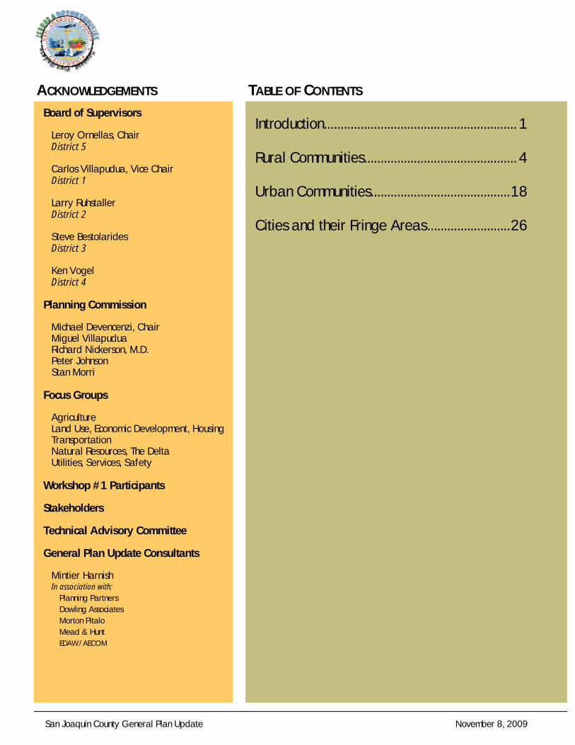
LOCKEFORD WATER TOWER
DOWNTOWN WOODBRIDGE
MORADA
LOCKEFORD CHRUCH DOWNTOWN LOCKEFORD
MOUNTAIN HOUSE
CCCOMMUNITYOMMUNITYOMMUNITY OOOVERVIEWSVERVIEWSVERVIEWS
San Joaquin County General Plan Update November 8, 2009 1
CCCOMMUNITYOMMUNITYOMMUNITY OOOVERVIEWSVERVIEWSVERVIEWS
The updated San Joaquin County General Plan will in-clude goals and policies that address the specific needs of unincorporated communities and areas adjacent to incorpo-rated cities (i.e., city fringe areas). Many of the issues in un-incorporated communities are related to infrastructure inade-quacies or safety concerns (e.g., flooding or water quality). This section is intended to provide an overview of each of the unincorporated communities and city fringe areas defined in the existing 2010 General Plan.
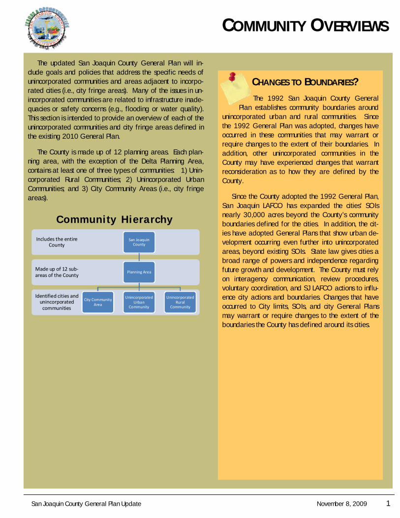
The County is made up of 12 planning areas. Each plan-ning area, with the exception of the Delta Planning Area, contains at least one of three types of communities: 1) Unin-corporated Rural Communities; 2) Unincorporated Urban Communities; and 3) City Community Areas (i.e., city fringe areas).
Identified cities and unincorporated communities
Made up of 12 sub‐areas of the County
Includes the entire County
San Joaquin County
Planning Area
City Community Area
Unincorporated Urban
Community
Unincorporated Rural
Community
Communi ty Hie rarchy
CHANGES TO BOUNDARIES?
The 1992 San Joaquin County General Plan establishes community boundaries around
unincorporated urban and rural communities. Since the 1992 General Plan was adopted, changes have occurred in these communities that may warrant or require changes to the extent of their boundaries. In addition, other unincorporated communities in the County may have experienced changes that warrant reconsideration as to how they are defined by the County.
Since the County adopted the 1992 General Plan, San Joaquin LAFCO has expanded the cities’ SOIs nearly 30,000 acres beyond the County’s community boundaries defined for the cities. In addition, the cit-ies have adopted General Plans that show urban de-velopment occurring even further into unincorporated areas, beyond existing SOIs. State law gives cities a broad range of powers and independence regarding future growth and development. The County must rely on interagency communication, review procedures, voluntary coordination, and SJ LAFCO actions to influ-ence city actions and boundaries. Changes that have occurred to City limits, SOIs, and city General Plans may warrant or require changes to the extent of the boundaries the County has defined around its cities.
2 November 8, 2009 San Joaquin County General Plan Update
CO
MM
UN
ITIE
S CITY COMMUNITY AREAS
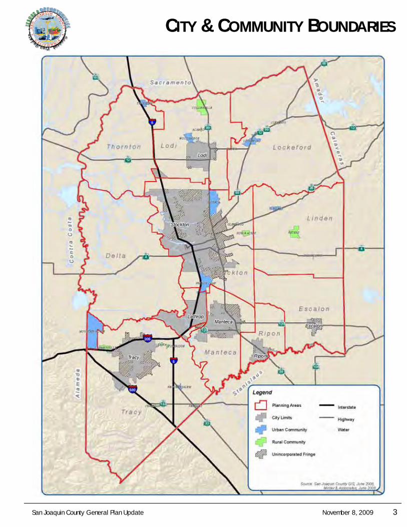
City community areas include incorporated city limits and unincorporated fringe areas around cities. There are seven cities in the county. The cities have jurisdiction over land within their city limits; the County maintains jurisdiction over areas outside the city limits. The city fringe areas include lands adjacent to the incorporated cities that are of interest to the County due to existing or potential future development.
URBAN COMMUNITY AREAS
Unincorporated urban community areas reflect population sizes, residential densities, public service levels, and an historic role as region-serving, commer-cial centers that distinguish them from the smaller rural communities. Unincorporated urban communities are under the jurisdiction of the County. Urban communities are typically serviced by community water and waste-water systems.
RURAL COMMUNITY AREAS
Unincorporated rural community areas are generally more than 50 acres in size, and have populations be-tween 100 and 1,000. Their character varies from his-toric towns originally established as stagecoach or rail stops, to isolated clusters of ranch-style residences on large lots. Many of these communities have small local-serving commercial areas at their major crossroads, an elementary school, a cemetery, and agricultural-support uses. Unlike urban communities, rural communities may have small community water systems but lack community sewer systems.
CCCOMMUNITYOMMUNITYOMMUNITY OOOVERVIEWSVERVIEWSVERVIEWS
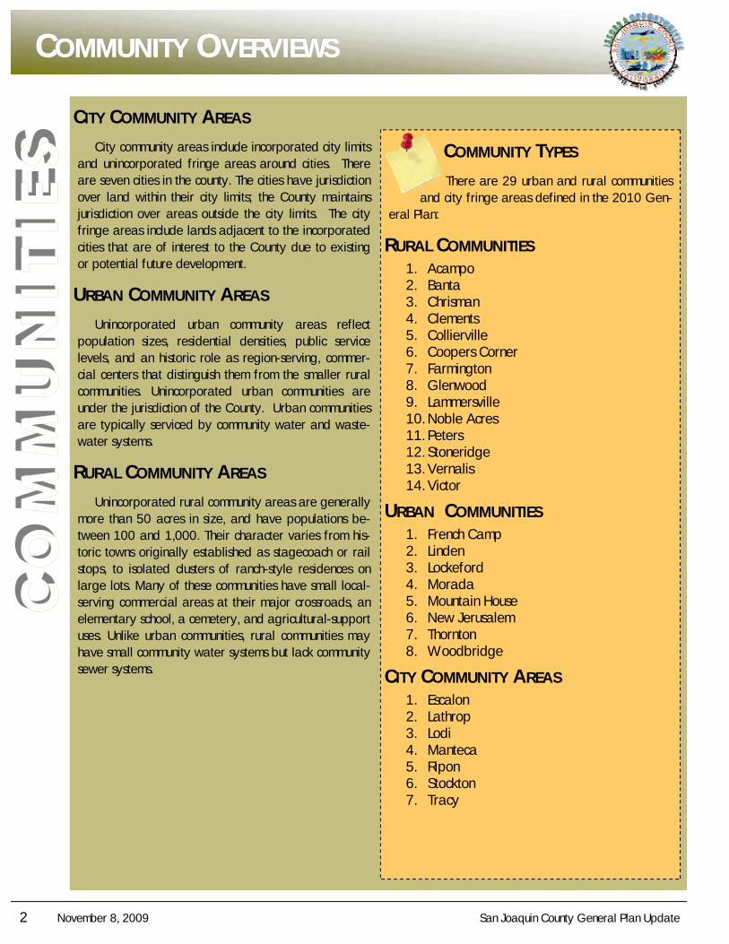
COMMUNITY TYPES
There are 29 urban and rural communities and city fringe areas defined in the 2010 Gen-
eral Plan:
RURAL COMMUNITIES 1. Acampo 2. Banta 3. Chrisman 4. Clements 5. Collierville 6. Coopers Corner 7. Farmington 8. Glenwood 9. Lammersville 10. Noble Acres 11. Peters 12. Stoneridge 13. Vernalis 14. Victor
URBAN COMMUNITIES 1. French Camp 2. Linden 3. Lockeford 4. Morada 5. Mountain House 6. New Jerusalem 7. Thornton 8. Woodbridge
CITY COMMUNITY AREAS 1. Escalon 2. Lathrop 3. Lodi 4. Manteca 5. Ripon 6. Stockton 7. Tracy
San Joaquin County General Plan Update November 8, 2009 3
CCCITYITYITY & C& C& COMMUNITYOMMUNITYOMMUNITY BBBOUNDARIESOUNDARIESOUNDARIES
4 November 8, 2009 San Joaquin County General Plan Update
CO
MM
UN
ITIE
S COMMUNITY PROFILE
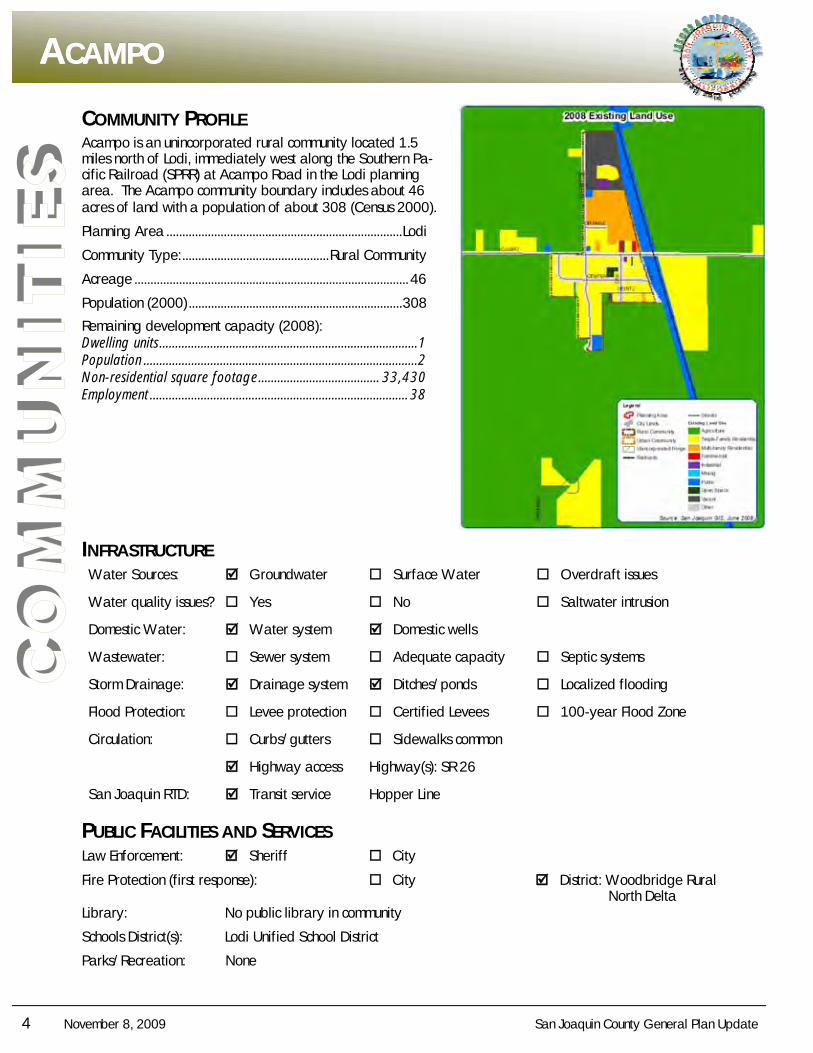
Acampo is an unincorporated rural community located 1.5 miles north of Lodi, immediately west along the Southern Pa-cific Railroad (SPRR) at Acampo Road in the Lodi planning area. The Acampo community boundary includes about 46 acres of land with a population of about 308 (Census 2000).
Planning Area .......................................................................... Lodi
Community Type: .............................................. Rural Community
Acreage ...................................................................................... 46
Population (2000) ................................................................... 308
Remaining development capacity (2008): Dwelling units ................................................................................. 1 Population ...................................................................................... 2 Non-residential square footage ...................................... 33,430 Employment ................................................................................. 38
INFRASTRUCTURE Water Sources: Groundwater Surface Water Overdraft issues
Water quality issues? Yes No Saltwater intrusion
Domestic Water: Water system Domestic wells
Wastewater: Sewer system Adequate capacity Septic systems
Storm Drainage: Drainage system Ditches/ponds Localized flooding
Flood Protection: Levee protection Certified Levees 100-year Flood Zone
Circulation: Curbs/gutters Sidewalks common
Highway access Highway(s): SR 26
San Joaquin RTD: Transit service Hopper Line
PUBLIC FACILITIES AND SERVICES Law Enforcement: Sheriff City
Fire Protection (first response): City District: Woodbridge Rural North Delta Library: No public library in community
Schools District(s): Lodi Unified School District
Parks/Recreation: None
AAACAMPOCAMPOCAMPO
San Joaquin County General Plan Update November 8, 2009 5
CO
MM
UN
ITIE
S
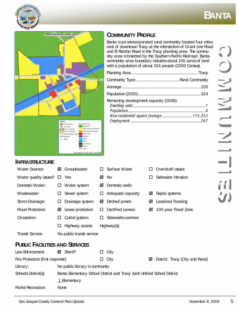
BBBANTAANTAANTA
COMMUNITY PROFILE Banta is an unincorporated rural community located four miles east of downtown Tracy at the intersection of Grant Line Road and El Rancho Road in the Tracy planning area. The commu-nity area is bisected by the Southern Pacific Railroad. Banta community area boundary includes about 105 acres of land with a population of about 324 people (2000 Census).
Planning Area ....................................................................... Tracy
Community Type: .............................................. Rural Community
Acreage .................................................................................... 105
Population (2000) ................................................................... 324
Remaining development capacity (2008): Dwelling units ............................................................................. 1 Population................................................................................... 4 Non-residential square footage ................................ 115,353 Employment ........................................................................... 267
INFRASTRUCTURE Water Sources: Groundwater Surface Water Overdraft issues
Water quality issues? Yes No Saltwater intrusion
Domestic Water: Water system Domestic wells
Wastewater: Sewer system Adequate capacity Septic systems
Storm Drainage: Drainage system Ditches/ponds Localized flooding
Flood Protection: Levee protection Certified Levees 100-year Flood Zone
Circulation: Curbs/gutters Sidewalks common
Highway access Highway(s):
Transit Service: No public transit service
PUBLIC FACILITIES AND SERVICES Law Enforcement: Sheriff City
Fire Protection (first response): City District: Tracy (City and Rural)
Library: No public library in community
Schools District(s): Banta Elementary School District and Tracy Joint Unified School District
1 Elementary
Parks/Recreation: None
6 November 8, 2009 San Joaquin County General Plan Update
CO
MM
UN
ITIE
S COMMUNITY PROFILE
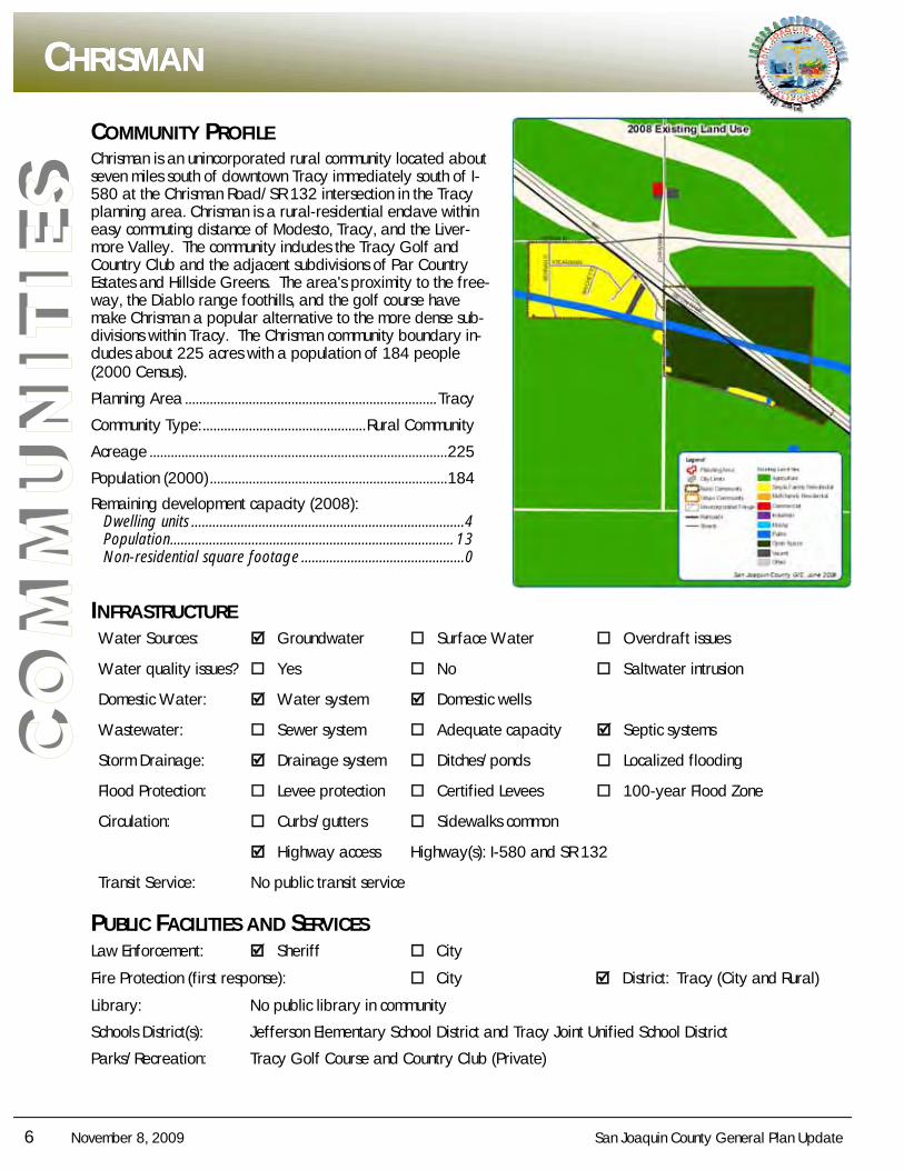
Chrisman is an unincorporated rural community located about seven miles south of downtown Tracy immediately south of I- 580 at the Chrisman Road/SR 132 intersection in the Tracy planning area. Chrisman is a rural-residential enclave within easy commuting distance of Modesto, Tracy, and the Liver-more Valley. The community includes the Tracy Golf and Country Club and the adjacent subdivisions of Par Country Estates and Hillside Greens. The area's proximity to the free-way, the Diablo range foothills, and the golf course have make Chrisman a popular alternative to the more dense sub-divisions within Tracy. The Chrisman community boundary in-cludes about 225 acres with a population of 184 people (2000 Census).
Planning Area ....................................................................... Tracy
Community Type: .............................................. Rural Community
Acreage .................................................................................... 225
Population (2000) ................................................................... 184
Remaining development capacity (2008): Dwelling units ............................................................................. 4 Population ................................................................................ 13 Non-residential square footage .............................................. 0
INFRASTRUCTURE Water Sources: Groundwater Surface Water Overdraft issues
Water quality issues? Yes No Saltwater intrusion
Domestic Water: Water system Domestic wells
Wastewater: Sewer system Adequate capacity Septic systems
Storm Drainage: Drainage system Ditches/ponds Localized flooding
Flood Protection: Levee protection Certified Levees 100-year Flood Zone
Circulation: Curbs/gutters Sidewalks common
Highway access Highway(s): I-580 and SR 132
Transit Service: No public transit service
PUBLIC FACILITIES AND SERVICES Law Enforcement: Sheriff City
Fire Protection (first response): City District: Tracy (City and Rural)
Library: No public library in community
Schools District(s): Jefferson Elementary School District and Tracy Joint Unified School District
Parks/Recreation: Tracy Golf Course and Country Club (Private)
CCCHRISMANHRISMANHRISMAN
San Joaquin County General Plan Update November 8, 2009 7
CO
MM
UN
ITIE
S
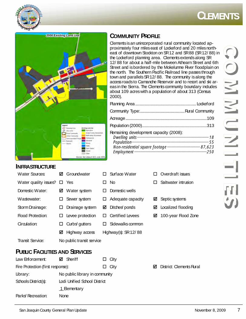
CCCLEMENTSLEMENTSLEMENTS
COMMUNITY PROFILE Clements is an unincorporated rural community located ap-proximately four miles east of Lockeford and 20 miles north-east of downtown Stockton on SR 12 and SR 88 (SR 12/88) in the Lockeford planning area. Clements extends along SR 12/88 for about a half-mile between Athearn Street and 6th Street and is bordered by the Mokelumne River floodplain on the north. The Southern Pacific Railroad line passes through town and parallels SR 12/88. The community is along the access roads to Camanche Reservoir and to resort and ski ar-eas in the Sierra. The Clements community boundary includes about 109 acres with a population of about 313 (Census 2000).
Planning Area ............................................................... Lockeford
Community Type: .............................................. Rural Community
Acreage .................................................................................... 109
Population (2000) ................................................................... 313
Remaining development capacity (2008): Dwelling units ·········································································· 18 Population················································································ 55 Non-residential square footage ·································· 87,623 Employment ··········································································· 250
INFRASTRUCTURE Water Sources: Groundwater Surface Water Overdraft issues
Water quality issues? Yes No Saltwater intrusion
Domestic Water: Water system Domestic wells
Wastewater: Sewer system Adequate capacity Septic systems
Storm Drainage: Drainage system Ditches/ponds Localized flooding
Flood Protection: Levee protection Certified Levees 100-year Flood Zone
Circulation: Curbs/gutters Sidewalks common
Highway access Highway(s): SR 12/88
Transit Service: No public transit service
PUBLIC FACILITIES AND SERVICES Law Enforcement: Sheriff City
Fire Protection (first response): City District: Clements Rural
Library: No public library in community
Schools District(s): Lodi Unified School District
1 Elementary
Parks/Recreation: None
8 November 8, 2009 San Joaquin County General Plan Update
CO
MM
UN
ITIE
S COMMUNITY PROFILE
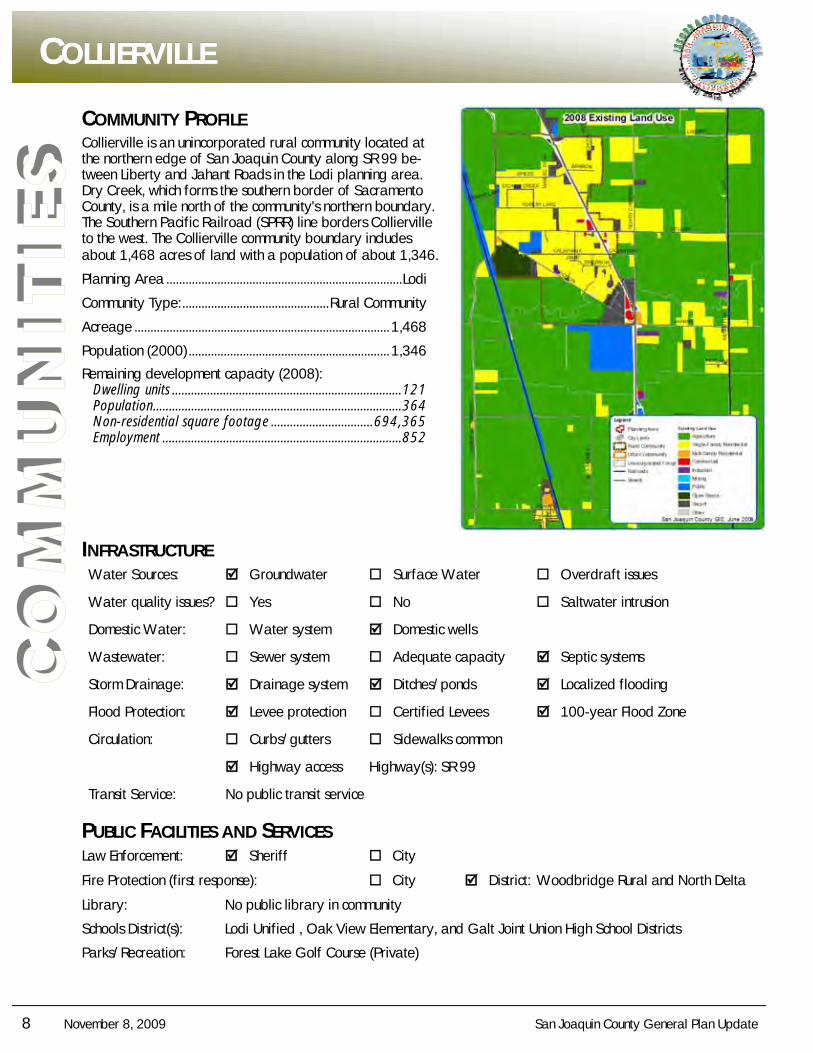
Collierville is an unincorporated rural community located at the northern edge of San Joaquin County along SR 99 be-tween Liberty and Jahant Roads in the Lodi planning area. Dry Creek, which forms the southern border of Sacramento County, is a mile north of the community's northern boundary. The Southern Pacific Railroad (SPRR) line borders Collierville to the west. The Collierville community boundary includes about 1,468 acres of land with a population of about 1,346.
Planning Area .......................................................................... Lodi
Community Type: .............................................. Rural Community
Acreage ................................................................................ 1,468
Population (2000) ............................................................... 1,346
Remaining development capacity (2008): Dwelling units ........................................................................ 121 Population .............................................................................. 364 Non-residential square footage ................................ 694,365 Employment ........................................................................... 852
INFRASTRUCTURE Water Sources: Groundwater Surface Water Overdraft issues
Water quality issues? Yes No Saltwater intrusion
Domestic Water: Water system Domestic wells
Wastewater: Sewer system Adequate capacity Septic systems
Storm Drainage: Drainage system Ditches/ponds Localized flooding
Flood Protection: Levee protection Certified Levees 100-year Flood Zone
Circulation: Curbs/gutters Sidewalks common
Highway access Highway(s): SR 99
Transit Service: No public transit service
PUBLIC FACILITIES AND SERVICES Law Enforcement: Sheriff City
Fire Protection (first response): City District: Woodbridge Rural and North Delta
Library: No public library in community
Schools District(s): Lodi Unified , Oak View Elementary, and Galt Joint Union High School Districts
Parks/Recreation: Forest Lake Golf Course (Private)
CCCOLLIERVILLEOLLIERVILLEOLLIERVILLE
San Joaquin County General Plan Update November 8, 2009 9
CO
MM
UN
ITIE
S
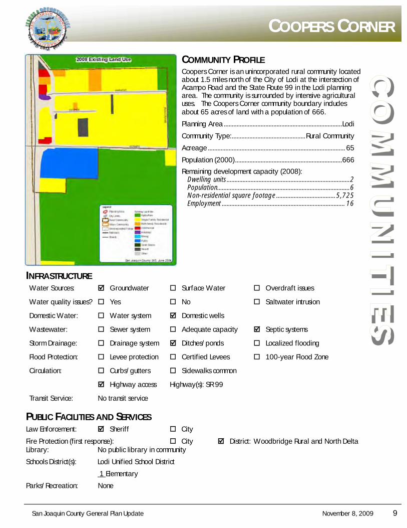
CCCOOPERSOOPERSOOPERS CCCORNERORNERORNER
COMMUNITY PROFILE Coopers Corner is an unincorporated rural community located about 1.5 miles north of the City of Lodi at the intersection of Acampo Road and the State Route 99 in the Lodi planning area. The community is surrounded by intensive agricultural uses. The Coopers Corner community boundary includes about 65 acres of land with a population of 666.
Planning Area .......................................................................... Lodi
Community Type: .............................................. Rural Community
Acreage ...................................................................................... 65
Population (2000) ................................................................... 666
Remaining development capacity (2008): Dwelling units ............................................................................. 2 Population................................................................................... 6 Non-residential square footage ..................................... 5,725 Employment ............................................................................. 16
INFRASTRUCTURE Water Sources: Groundwater Surface Water Overdraft issues
Water quality issues? Yes No Saltwater intrusion
Domestic Water: Water system Domestic wells
Wastewater: Sewer system Adequate capacity Septic systems
Storm Drainage: Drainage system Ditches/ponds Localized flooding
Flood Protection: Levee protection Certified Levees 100-year Flood Zone
Circulation: Curbs/gutters Sidewalks common
Highway access Highway(s): SR 99
Transit Service: No transit service
PUBLIC FACILITIES AND SERVICES Law Enforcement: Sheriff City
Fire Protection (first response): City District: Woodbridge Rural and North Delta Library: No public library in community
Schools District(s): Lodi Unified School District
1 Elementary
Parks/Recreation: None
10 November 8, 2009 San Joaquin County General Plan Update
CO
MM
UN
ITIE
S COMMUNITY PROFILE
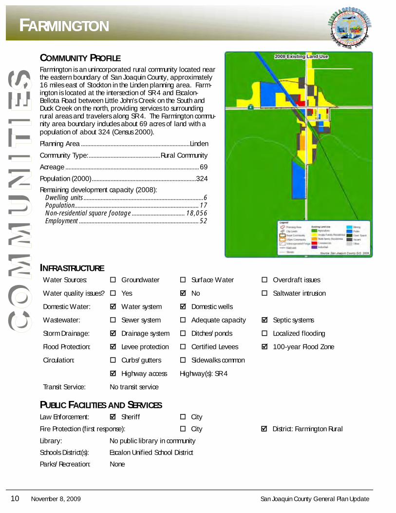
Farmington is an unincorporated rural community located near the eastern boundary of San Joaquin County, approximately 16 miles east of Stockton in the Linden planning area. Farm-ington is located at the intersection of SR 4 and Escalon-Bellota Road between Little John’s Creek on the South and Duck Creek on the north, providing services to surrounding rural areas and travelers along SR 4. The Farmington commu-nity area boundary includes about 69 acres of land with a population of about 324 (Census 2000).
Planning Area ...................................................................... Linden
Community Type: .............................................. Rural Community
Acreage ...................................................................................... 69
Population (2000) ................................................................... 324
Remaining development capacity (2008): Dwelling units ............................................................................. 6 Population ................................................................................ 17 Non-residential square footage .................................. 18,056 Employment ............................................................................. 52
INFRASTRUCTURE Water Sources: Groundwater Surface Water Overdraft issues
Water quality issues? Yes No Saltwater intrusion
Domestic Water: Water system Domestic wells
Wastewater: Sewer system Adequate capacity Septic systems
Storm Drainage: Drainage system Ditches/ponds Localized flooding
Flood Protection: Levee protection Certified Levees 100-year Flood Zone
Circulation: Curbs/gutters Sidewalks common
Highway access Highway(s): SR 4
Transit Service: No transit service
PUBLIC FACILITIES AND SERVICES Law Enforcement: Sheriff City
Fire Protection (first response): City District: Farmington Rural
Library: No public library in community
Schools District(s): Escalon Unified School District
Parks/Recreation: None
FFFARMINGTONARMINGTONARMINGTON
San Joaquin County General Plan Update November 8, 2009 11
CO
MM
UN
ITIE
S
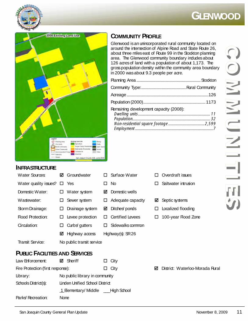
GGGLENWOODLENWOODLENWOOD
COMMUNITY PROFILE Glenwood is an unincorporated rural community located on around the intersection of Alpine Road and State Route 26, about three miles east of Route 99 in the Stockton planning area. The Glenwood community boundary includes about 126 acres of land with a population of about 1,173. The gross population density within the community area boundary in 2000 was about 9.3 people per acre.
Planning Area .................................................................. Stockton
Community Type: .............................................. Rural Community
Acreage .................................................................................... 126
Population (2000) ................................................................ 1173
Remaining development capacity (2008): Dwelling units .......................................................................... 11 Population................................................................................ 32 Non-residential square footage ..................................... 2,599 Employment ................................................................................ 7
INFRASTRUCTURE Water Sources: Groundwater Surface Water Overdraft issues
Water quality issues? Yes No Saltwater intrusion
Domestic Water: Water system Domestic wells
Wastewater: Sewer system Adequate capacity Septic systems
Storm Drainage: Drainage system Ditches/ponds Localized flooding
Flood Protection: Levee protection Certified Levees 100-year Flood Zone
Circulation: Curbs/gutters Sidewalks common
Highway access Highway(s): SR 26
Transit Service: No public transit service
PUBLIC FACILITIES AND SERVICES Law Enforcement: Sheriff City
Fire Protection (first response): City District: Waterloo-Morada Rural
Library: No public library in community
Schools District(s): Linden Unified School District
1 Elementary/Middle ___High School
Parks/Recreation: None
12 November 8, 2009 San Joaquin County General Plan Update
CO
MM
UN
ITIE
S COMMUNITY PROFILE
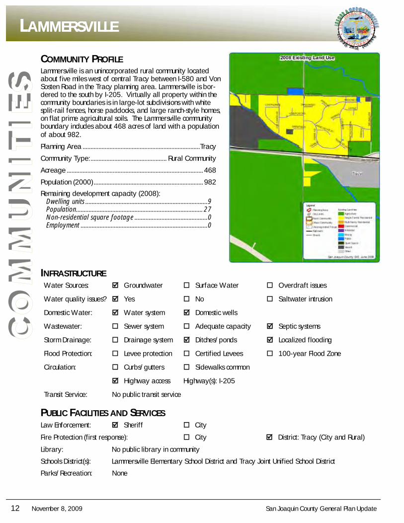
Lammersville is an unincorporated rural community located about five miles west of central Tracy between I-580 and Von Sosten Road in the Tracy planning area. Lammersville is bor-dered to the south by I-205. Virtually all property within the community boundaries is in large-lot subdivisions with white split-rail fences, horse paddocks, and large ranch-style homes, on flat prime agricultural soils. The Lammersville community boundary includes about 468 acres of land with a population of about 982.
Planning Area .......................................................................... Tracy
Community Type: ................................................ Rural Community
Acreage ...................................................................................... 468
Population (2000) ..................................................................... 982
Remaining development capacity (2008): Dwelling units ............................................................................. 9 Population ................................................................................ 27 Non-residential square footage .............................................. 0 Employment ................................................................................ 0
INFRASTRUCTURE Water Sources: Groundwater Surface Water Overdraft issues
Water quality issues? Yes No Saltwater intrusion
Domestic Water: Water system Domestic wells
Wastewater: Sewer system Adequate capacity Septic systems
Storm Drainage: Drainage system Ditches/ponds Localized flooding
Flood Protection: Levee protection Certified Levees 100-year Flood Zone
Circulation: Curbs/gutters Sidewalks common
Highway access Highway(s): I-205
Transit Service: No public transit service
PUBLIC FACILITIES AND SERVICES Law Enforcement: Sheriff City
Fire Protection (first response): City District: Tracy (City and Rural)
Library: No public library in community
Schools District(s): Lammersville Elementary School District and Tracy Joint Unified School District
Parks/Recreation: None
LLLAMMERSVILLEAMMERSVILLEAMMERSVILLE
San Joaquin County General Plan Update November 8, 2009 13
CO
MM
UN
ITIE
S
NNNOBLEOBLEOBLE AAACRESCRESCRES
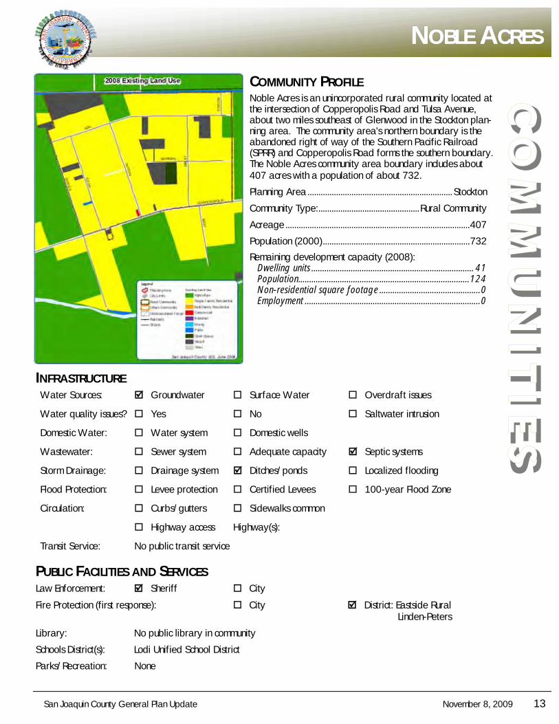
COMMUNITY PROFILE Noble Acres is an unincorporated rural community located at the intersection of Copperopolis Road and Tulsa Avenue, about two miles southeast of Glenwood in the Stockton plan-ning area. The community area's northern boundary is the abandoned right of way of the Southern Pacific Railroad (SPRR) and Copperopolis Road forms the southern boundary. The Noble Acres community area boundary includes about 407 acres with a population of about 732.
Planning Area .................................................................. Stockton
Community Type: .............................................. Rural Community
Acreage .................................................................................... 407
Population (2000) ................................................................... 732
Remaining development capacity (2008): Dwelling units .......................................................................... 41 Population.............................................................................. 124 Non-residential square footage .............................................. 0 Employment ................................................................................ 0
INFRASTRUCTURE Water Sources: Groundwater Surface Water Overdraft issues
Water quality issues? Yes No Saltwater intrusion
Domestic Water: Water system Domestic wells
Wastewater: Sewer system Adequate capacity Septic systems
Storm Drainage: Drainage system Ditches/ponds Localized flooding
Flood Protection: Levee protection Certified Levees 100-year Flood Zone
Circulation: Curbs/gutters Sidewalks common
Highway access Highway(s):
Transit Service: No public transit service
PUBLIC FACILITIES AND SERVICES Law Enforcement: Sheriff City
Fire Protection (first response): City District: Eastside Rural Linden-Peters
Library: No public library in community
Schools District(s): Lodi Unified School District
Parks/Recreation: None
14 November 8, 2009 San Joaquin County General Plan Update
CO
MM
UN
ITIE
S COMMUNITY PROFILE
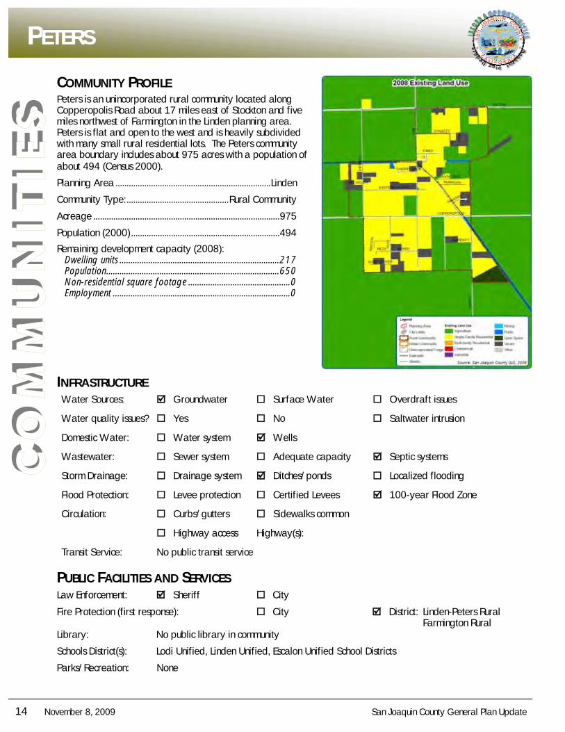
Peters is an unincorporated rural community located along Copperopolis Road about 17 miles east of Stockton and five miles northwest of Farmington in the Linden planning area. Peters is flat and open to the west and is heavily subdivided with many small rural residential lots. The Peters community area boundary includes about 975 acres with a population of about 494 (Census 2000).
Planning Area ...................................................................... Linden
Community Type: .............................................. Rural Community
Acreage .................................................................................... 975
Population (2000) ................................................................... 494
Remaining development capacity (2008): Dwelling units ........................................................................ 217 Population .............................................................................. 650 Non-residential square footage .............................................. 0 Employment ................................................................................ 0
INFRASTRUCTURE Water Sources: Groundwater Surface Water Overdraft issues
Water quality issues? Yes No Saltwater intrusion
Domestic Water: Water system Wells
Wastewater: Sewer system Adequate capacity Septic systems
Storm Drainage: Drainage system Ditches/ponds Localized flooding
Flood Protection: Levee protection Certified Levees 100-year Flood Zone
Circulation: Curbs/gutters Sidewalks common
Highway access Highway(s):
Transit Service: No public transit service
PUBLIC FACILITIES AND SERVICES Law Enforcement: Sheriff City
Fire Protection (first response): City District: Linden-Peters Rural Farmington Rural Library: No public library in community
Schools District(s): Lodi Unified, Linden Unified, Escalon Unified School Districts
Parks/Recreation: None
PPPETERSETERSETERS
San Joaquin County General Plan Update November 8, 2009 15
CO
MM
UN
ITIE
S
SSSTONERIDGETONERIDGETONERIDGE
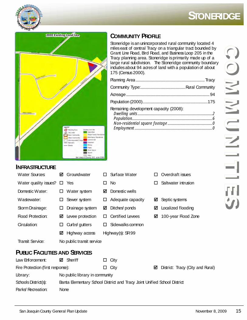
COMMUNITY PROFILE Stoneridge is an unincorporated rural community located 4 miles east of central Tracy on a triangular tract bounded by Grant Line Road, Bird Road, and Business Loop 205 in the Tracy planning area. Stoneridge is primarily made up of a large rural subdivision. The Stoneridge community boundary includes about 94 acres of land with a population of about 175 (Census 2000).
Planning Area ....................................................................... Tracy
Community Type: .............................................. Rural Community
Acreage ...................................................................................... 94
Population (2000) ................................................................... 175
Remaining development capacity (2008): Dwelling units ............................................................................. 2 Population................................................................................... 6 Non-residential square footage .............................................. 0 Employment ................................................................................ 0
INFRASTRUCTURE Water Sources: Groundwater Surface Water Overdraft issues
Water quality issues? Yes No Saltwater intrusion
Domestic Water: Water system Domestic wells
Wastewater: Sewer system Adequate capacity Septic systems
Storm Drainage: Drainage system Ditches/ponds Localized flooding
Flood Protection: Levee protection Certified Levees 100-year Flood Zone
Circulation: Curbs/gutters Sidewalks common
Highway access Highway(s): SR 99
Transit Service: No public transit service
PUBLIC FACILITIES AND SERVICES Law Enforcement: Sheriff City
Fire Protection (first response): City District: Tracy (City and Rural)
Library: No public library in community
Schools District(s): Banta Elementary School District and Tracy Joint Unified School District
Parks/Recreation: None
16 November 8, 2009 San Joaquin County General Plan Update
CO
MM
UN
ITIE
S COMMUNITY PROFILE
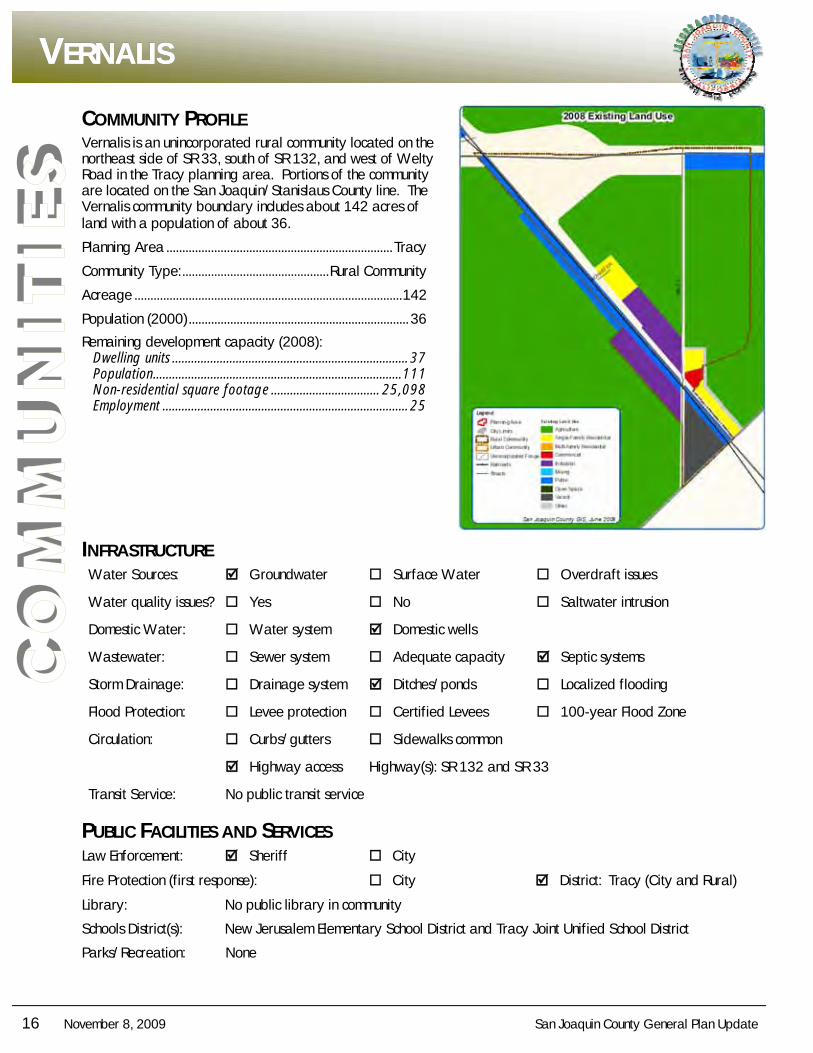
Vernalis is an unincorporated rural community located on the northeast side of SR 33, south of SR 132, and west of Welty Road in the Tracy planning area. Portions of the community are located on the San Joaquin/Stanislaus County line. The Vernalis community boundary includes about 142 acres of land with a population of about 36.
Planning Area ....................................................................... Tracy
Community Type: .............................................. Rural Community
Acreage .................................................................................... 142
Population (2000) ..................................................................... 36
Remaining development capacity (2008): Dwelling units .......................................................................... 37 Population .............................................................................. 111 Non-residential square footage .................................. 25,098 Employment ............................................................................. 25
INFRASTRUCTURE Water Sources: Groundwater Surface Water Overdraft issues
Water quality issues? Yes No Saltwater intrusion
Domestic Water: Water system Domestic wells
Wastewater: Sewer system Adequate capacity Septic systems
Storm Drainage: Drainage system Ditches/ponds Localized flooding
Flood Protection: Levee protection Certified Levees 100-year Flood Zone
Circulation: Curbs/gutters Sidewalks common
Highway access Highway(s): SR 132 and SR 33
Transit Service: No public transit service
PUBLIC FACILITIES AND SERVICES Law Enforcement: Sheriff City
Fire Protection (first response): City District: Tracy (City and Rural)
Library: No public library in community
Schools District(s): New Jerusalem Elementary School District and Tracy Joint Unified School District
Parks/Recreation: None
VVVERNALISERNALISERNALIS
San Joaquin County General Plan Update November 8, 2009 17
CO
MM
UN
ITIE
S
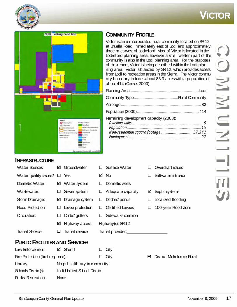
VVVICTORICTORICTOR
COMMUNITY PROFILE Victor is an unincorporated rural community located on SR 12 at Bruella Road, immediately east of Lodi and approximately three miles west of Lockeford. Most of Victor is located in the Lockeford planning area, however a small western part of the community is also in the Lodi planning area. For the purposes of this report, Victor is being described within the Lodi plan-ning area. Victor is bisected by SR 12, which provides access from Lodi to recreation areas in the Sierra. The Victor commu-nity boundary includes about 83.3 acres with a population of about 414 (Census 2000).
Planning Area .......................................................................... Lodi
Community Type: .............................................. Rural Community
Acreage ...................................................................................... 83
Population (2000) ................................................................... 414
Remaining development capacity (2008): Dwelling units ............................................................................. 5 Population................................................................................ 15 Non-residential square footage .................................. 57,342 Employment ............................................................................. 97
INFRASTRUCTURE Water Sources: Groundwater Surface Water Overdraft issues
Water quality issues? Yes No Saltwater intrusion
Domestic Water: Water system Domestic wells
Wastewater: Sewer system Adequate capacity Septic systems
Storm Drainage: Drainage system Ditches/ponds Localized flooding
Flood Protection: Levee protection Certified Levees 100-year Flood Zone
Circulation: Curbs/gutters Sidewalks common
Highway access Highway(s): SR 12
Transit Service: Transit service Transit provider:___________________
PUBLIC FACILITIES AND SERVICES Law Enforcement: Sheriff City
Fire Protection (first response): City District: Mokelumne Rural
Library: No public library in community
Schools District(s): Lodi Unified School District
Parks/Recreation: None
18 November 8, 2009 San Joaquin County General Plan Update
CO
MM
UN
ITIE
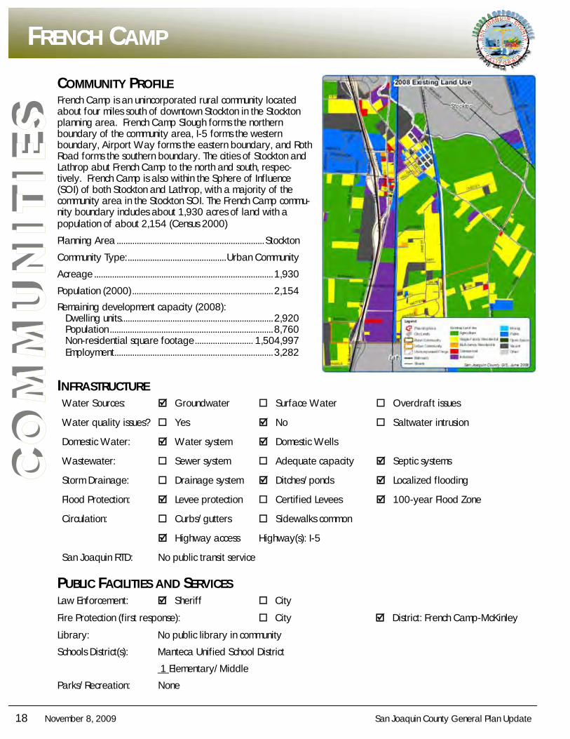
S COMMUNITY PROFILE
French Camp is an unincorporated rural community located about four miles south of downtown Stockton in the Stockton planning area. French Camp Slough forms the northern boundary of the community area, I-5 forms the western boundary, Airport Way forms the eastern boundary, and Roth Road forms the southern boundary. The cities of Stockton and Lathrop abut French Camp to the north and south, respec-tively. French Camp is also within the Sphere of Influence (SOI) of both Stockton and Lathrop, with a majority of the community area in the Stockton SOI. The French Camp commu-nity boundary includes about 1,930 acres of land with a population of about 2,154 (Census 2000)
Planning Area .................................................................. Stockton
Community Type: ............................................ Urban Community
Acreage ................................................................................ 1,930
Population (2000) ............................................................... 2,154
Remaining development capacity (2008): Dwelling units .................................................................... 2,920 Population ......................................................................... 8,760 Non-residential square footage .......................... 1,504,997 Employment ....................................................................... 3,282
INFRASTRUCTURE Water Sources: Groundwater Surface Water Overdraft issues
Water quality issues? Yes No Saltwater intrusion
Domestic Water: Water system Domestic Wells
Wastewater: Sewer system Adequate capacity Septic systems
Storm Drainage: Drainage system Ditches/ponds Localized flooding
Flood Protection: Levee protection Certified Levees 100-year Flood Zone
Circulation: Curbs/gutters Sidewalks common
Highway access Highway(s): I-5
San Joaquin RTD: No public transit service
PUBLIC FACILITIES AND SERVICES Law Enforcement: Sheriff City
Fire Protection (first response): City District: French Camp-McKinley
Library: No public library in community
Schools District(s): Manteca Unified School District
1 Elementary/Middle
Parks/Recreation: None
FFFRENCHRENCHRENCH CCCAMPAMPAMP
San Joaquin County General Plan Update November 8, 2009 19
CO
MM
UN
ITIE
S
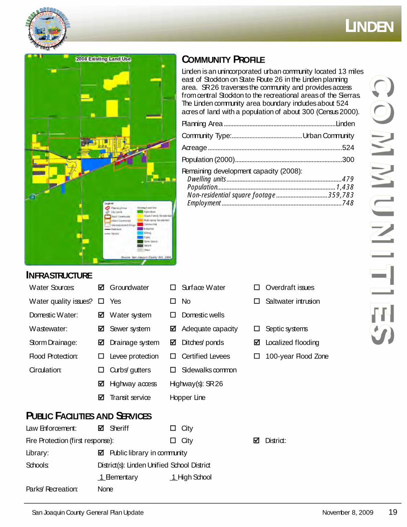
LLLINDENINDENINDEN
COMMUNITY PROFILE Linden is an unincorporated urban community located 13 miles east of Stockton on State Route 26 in the Linden planning area. SR 26 traverses the community and provides access from central Stockton to the recreational areas of the Sierras. The Linden community area boundary includes about 524 acres of land with a population of about 300 (Census 2000).
Planning Area ...................................................................... Linden
Community Type: ............................................ Urban Community
Acreage .................................................................................... 524
Population (2000) ................................................................... 300
Remaining development capacity (2008): Dwelling units ........................................................................ 479 Population.......................................................................... 1,438 Non-residential square footage ................................ 359,783 Employment ........................................................................... 748
INFRASTRUCTURE Water Sources: Groundwater Surface Water Overdraft issues
Water quality issues? Yes No Saltwater intrusion
Domestic Water: Water system Domestic wells
Wastewater: Sewer system Adequate capacity Septic systems
Storm Drainage: Drainage system Ditches/ponds Localized flooding
Flood Protection: Levee protection Certified Levees 100-year Flood Zone
Circulation: Curbs/gutters Sidewalks common
Highway access Highway(s): SR 26
Transit service Hopper Line
PUBLIC FACILITIES AND SERVICES Law Enforcement: Sheriff City
Fire Protection (first response): City District:
Library: Public library in community
Schools: District(s): Linden Unified School District
1 Elementary 1 High School
Parks/Recreation: None
20 November 8, 2009 San Joaquin County General Plan Update
CO
MM
UN
ITIE
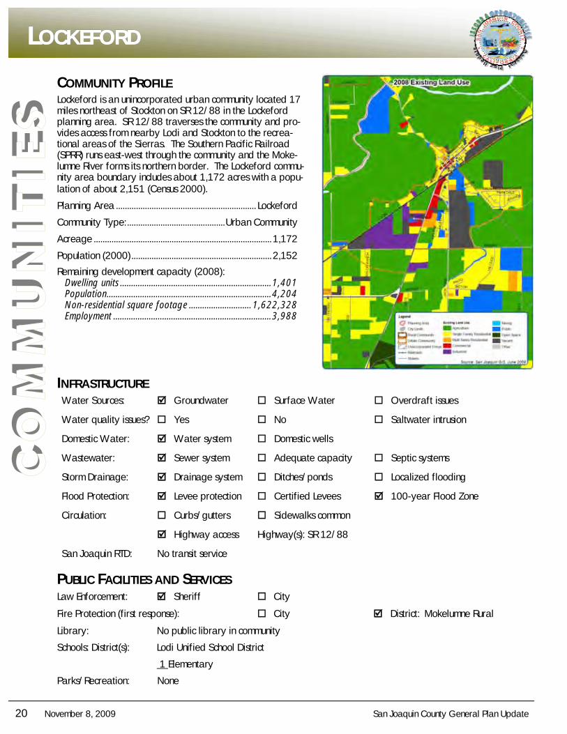
S COMMUNITY PROFILE
Lockeford is an unincorporated urban community located 17 miles northeast of Stockton on SR 12/88 in the Lockeford planning area. SR 12/88 traverses the community and pro-vides access from nearby Lodi and Stockton to the recrea-tional areas of the Sierras. The Southern Pacific Railroad (SPRR) runs east-west through the community and the Moke-lumne River forms its northern border. The Lockeford commu-nity area boundary includes about 1,172 acres with a popu-lation of about 2,151 (Census 2000).
Planning Area ............................................................... Lockeford
Community Type: ............................................ Urban Community
Acreage ................................................................................ 1,172
Population (2000) ............................................................... 2,152
Remaining development capacity (2008): Dwelling units .................................................................... 1,401 Population .......................................................................... 4,204 Non-residential square footage ............................ 1,622,328 Employment ....................................................................... 3,988
INFRASTRUCTURE Water Sources: Groundwater Surface Water Overdraft issues
Water quality issues? Yes No Saltwater intrusion
Domestic Water: Water system Domestic wells
Wastewater: Sewer system Adequate capacity Septic systems
Storm Drainage: Drainage system Ditches/ponds Localized flooding
Flood Protection: Levee protection Certified Levees 100-year Flood Zone
Circulation: Curbs/gutters Sidewalks common
Highway access Highway(s): SR 12/88
San Joaquin RTD: No transit service
PUBLIC FACILITIES AND SERVICES Law Enforcement: Sheriff City
Fire Protection (first response): City District: Mokelumne Rural
Library: No public library in community
Schools: District(s): Lodi Unified School District
1 Elementary
Parks/Recreation: None
LLLOCKEFORDOCKEFORDOCKEFORD
San Joaquin County General Plan Update November 8, 2009 21
CO
MM
UN
ITIE
S
MMMORADAORADAORADA
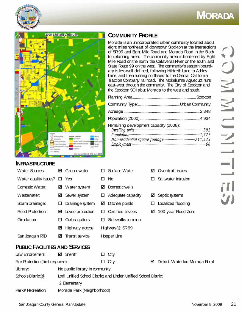
COMMUNITY PROFILE Morada is an unincorporated urban community located about eight miles northeast of downtown Stockton at the intersections of SR 99 and Eight Mile Road and Morada Road in the Stock-ton planning area. The community area is bordered by Eight Mile Road on the north, the Calaveras River on the south, and State Route 99 on the west. The community's eastern bound-ary is less well-defined, following Hildreth Lane to Ashley Lane, and then running northwest to the Central California Traction Company railroad. The Mokelumne Aqueduct runs east-west through the community. The City of Stockton and the Stockton SOI abut Morada to the west and south.
Planning Area .................................................................. Stockton
Community Type: ............................................ Urban Community
Acreage ................................................................................ 2,348
Population (2000) ............................................................... 4,934
Remaining development capacity (2008): Dwelling units ········································································ 592 Population·········································································· 1,777 Non-residential square footage ································ 211,525 Employment ············································································· 60
INFRASTRUCTURE Water Sources: Groundwater Surface Water Overdraft issues
Water quality issues? Yes No Saltwater intrusion
Domestic Water: Water system Domestic wells
Wastewater: Sewer system Adequate capacity Septic systems
Storm Drainage: Drainage system Ditches/ponds Localized flooding
Flood Protection: Levee protection Certified Levees 100-year Flood Zone
Circulation: Curbs/gutters Sidewalks common
Highway access Highway(s): SR 99
San Joaquin RTD: Transit service Hopper Line
PUBLIC FACILITIES AND SERVICES Law Enforcement: Sheriff City
Fire Protection (first response): City District: Waterloo-Morada Rural
Library: No public library in community
Schools District(s): Lodi Unified School District and Linden Unified School District
2 Elementary
Parks/Recreation: Morada Park (Neighborhood)
22 November 8, 2009 San Joaquin County General Plan Update
CO
MM
UN
ITIE
S COMMUNITY PROFILE
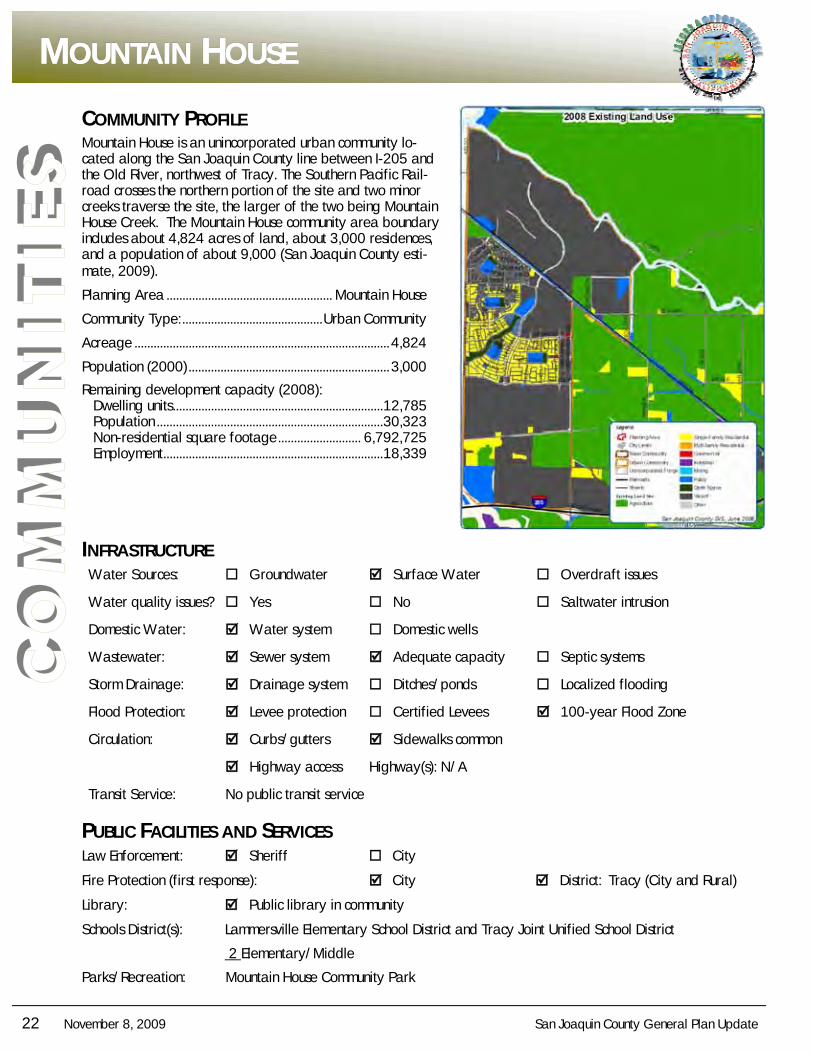
Mountain House is an unincorporated urban community lo-cated along the San Joaquin County line between I-205 and the Old River, northwest of Tracy. The Southern Pacific Rail-road crosses the northern portion of the site and two minor creeks traverse the site, the larger of the two being Mountain House Creek. The Mountain House community area boundary includes about 4,824 acres of land, about 3,000 residences, and a population of about 9,000 (San Joaquin County esti-mate, 2009).
Planning Area .................................................... Mountain House
Community Type: ............................................ Urban Community
Acreage ................................................................................ 4,824
Population (2000) ............................................................... 3,000
Remaining development capacity (2008): Dwelling units .................................................................. 12,785 Population ....................................................................... 30,323 Non-residential square footage .......................... 6,792,725 Employment ..................................................................... 18,339
INFRASTRUCTURE Water Sources: Groundwater Surface Water Overdraft issues
Water quality issues? Yes No Saltwater intrusion
Domestic Water: Water system Domestic wells
Wastewater: Sewer system Adequate capacity Septic systems
Storm Drainage: Drainage system Ditches/ponds Localized flooding
Flood Protection: Levee protection Certified Levees 100-year Flood Zone
Circulation: Curbs/gutters Sidewalks common
Highway access Highway(s): N/A
Transit Service: No public transit service
PUBLIC FACILITIES AND SERVICES Law Enforcement: Sheriff City
Fire Protection (first response): City District: Tracy (City and Rural)
Library: Public library in community
Schools District(s): Lammersville Elementary School District and Tracy Joint Unified School District
2 Elementary/Middle
Parks/Recreation: Mountain House Community Park
MMMOUNTAINOUNTAINOUNTAIN HHHOUSEOUSEOUSE
San Joaquin County General Plan Update November 8, 2009 23
CO
MM
UN
ITIE
S
NNNEWEWEW JJJERUSALEMERUSALEMERUSALEM
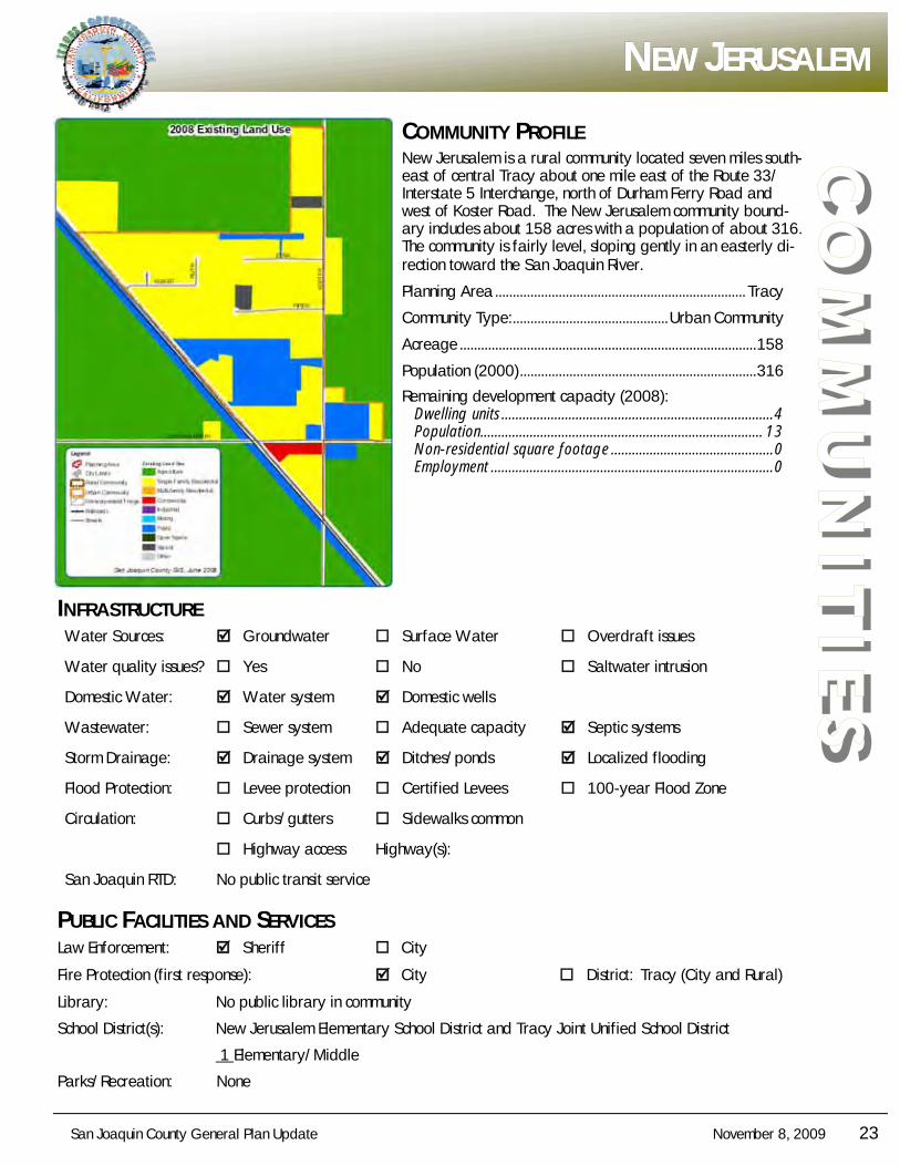
COMMUNITY PROFILE New Jerusalem is a rural community located seven miles south-east of central Tracy about one mile east of the Route 33/Interstate 5 Interchange, north of Durham Ferry Road and west of Koster Road. The New Jerusalem community bound-ary includes about 158 acres with a population of about 316. The community is fairly level, sloping gently in an easterly di-rection toward the San Joaquin River.
Planning Area ....................................................................... Tracy
Community Type: ............................................ Urban Community
Acreage .................................................................................... 158
Population (2000) ................................................................... 316
Remaining development capacity (2008): Dwelling units ............................................................................. 4 Population................................................................................ 13 Non-residential square footage .............................................. 0 Employment ................................................................................ 0
INFRASTRUCTURE Water Sources: Groundwater Surface Water Overdraft issues
Water quality issues? Yes No Saltwater intrusion
Domestic Water: Water system Domestic wells
Wastewater: Sewer system Adequate capacity Septic systems
Storm Drainage: Drainage system Ditches/ponds Localized flooding
Flood Protection: Levee protection Certified Levees 100-year Flood Zone
Circulation: Curbs/gutters Sidewalks common
Highway access Highway(s):
San Joaquin RTD: No public transit service
PUBLIC FACILITIES AND SERVICES Law Enforcement: Sheriff City
Fire Protection (first response): City District: Tracy (City and Rural)
Library: No public library in community
School District(s): New Jerusalem Elementary School District and Tracy Joint Unified School District
1 Elementary/Middle
Parks/Recreation: None
24 November 8, 2009 San Joaquin County General Plan Update
CO
MM
UN
ITIE
S COMMUNITY PROFILE
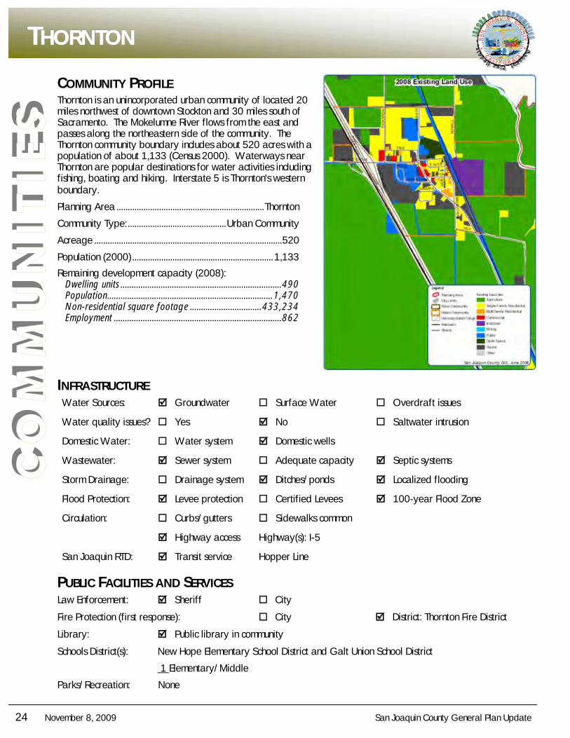
Thornton is an unincorporated urban community of located 20 miles northwest of downtown Stockton and 30 miles south of Sacramento. The Mokelumne River flows from the east and passes along the northeastern side of the community. The Thornton community boundary includes about 520 acres with a population of about 1,133 (Census 2000). Waterways near Thornton are popular destinations for water activities including fishing, boating and hiking. Interstate 5 is Thornton's western boundary.
Planning Area .................................................................. Thornton
Community Type: ............................................ Urban Community
Acreage .................................................................................... 520
Population (2000) ............................................................... 1,133
Remaining development capacity (2008): Dwelling units ........................................................................ 490 Population .......................................................................... 1,470 Non-residential square footage ................................ 433,234 Employment ........................................................................... 862
INFRASTRUCTURE Water Sources: Groundwater Surface Water Overdraft issues
Water quality issues? Yes No Saltwater intrusion
Domestic Water: Water system Domestic wells
Wastewater: Sewer system Adequate capacity Septic systems
Storm Drainage: Drainage system Ditches/ponds Localized flooding
Flood Protection: Levee protection Certified Levees 100-year Flood Zone
Circulation: Curbs/gutters Sidewalks common
Highway access Highway(s): I-5
San Joaquin RTD: Transit service Hopper Line
PUBLIC FACILITIES AND SERVICES Law Enforcement: Sheriff City
Fire Protection (first response): City District: Thornton Fire District
Library: Public library in community
Schools District(s): New Hope Elementary School District and Galt Union School District
1 Elementary/Middle
Parks/Recreation: None
TTTHORNTONHORNTONHORNTON
San Joaquin County General Plan Update November 8, 2009 25
CO
MM
UN
ITIE
S
WWWOODBRIDGEOODBRIDGEOODBRIDGE
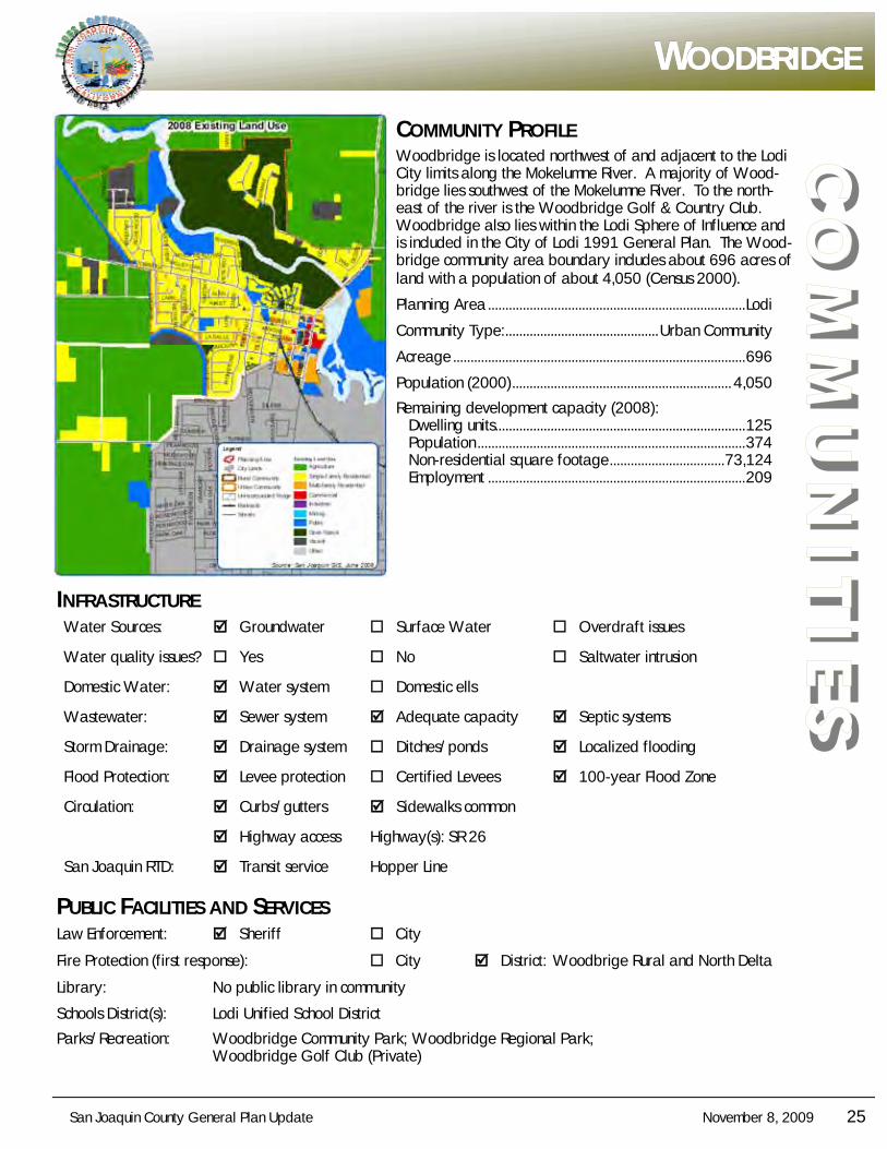
COMMUNITY PROFILE Woodbridge is located northwest of and adjacent to the Lodi City limits along the Mokelumne River. A majority of Wood-bridge lies southwest of the Mokelumne River. To the north-east of the river is the Woodbridge Golf & Country Club. Woodbridge also lies within the Lodi Sphere of Influence and is included in the City of Lodi 1991 General Plan. The Wood-bridge community area boundary includes about 696 acres of land with a population of about 4,050 (Census 2000).
Planning Area .......................................................................... Lodi
Community Type: ............................................ Urban Community
Acreage .................................................................................... 696
Population (2000) ............................................................... 4,050
Remaining development capacity (2008): Dwelling units........................................................................ 125 Population ............................................................................. 374 Non-residential square footage ................................. 73,124 Employment .......................................................................... 209
INFRASTRUCTURE Water Sources: Groundwater Surface Water Overdraft issues
Water quality issues? Yes No Saltwater intrusion
Domestic Water: Water system Domestic ells
Wastewater: Sewer system Adequate capacity Septic systems
Storm Drainage: Drainage system Ditches/ponds Localized flooding
Flood Protection: Levee protection Certified Levees 100-year Flood Zone
Circulation: Curbs/gutters Sidewalks common
Highway access Highway(s): SR 26
San Joaquin RTD: Transit service Hopper Line
PUBLIC FACILITIES AND SERVICES Law Enforcement: Sheriff City
Fire Protection (first response): City District: Woodbrige Rural and North Delta
Library: No public library in community
Schools District(s): Lodi Unified School District
Parks/Recreation: Woodbridge Community Park; Woodbridge Regional Park; Woodbridge Golf Club (Private)
26 November 8, 2009 San Joaquin County General Plan Update
CO
MM
UN
ITIE
S COMMUNITY PROFILE
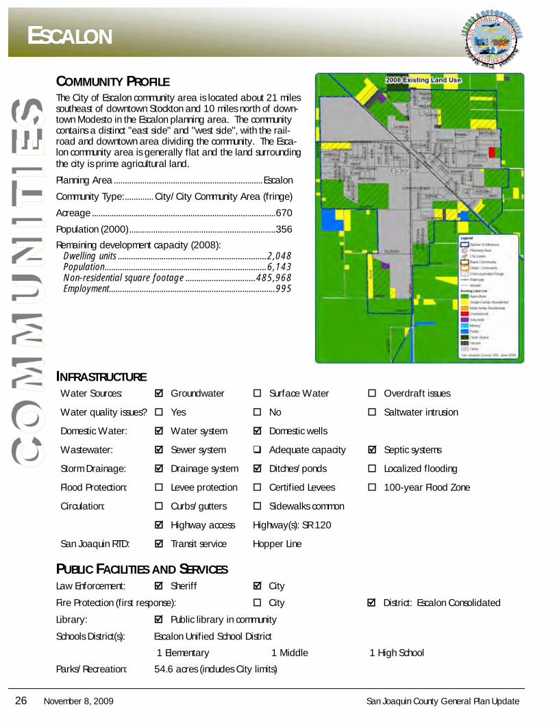
The City of Escalon community area is located about 21 miles southeast of downtown Stockton and 10 miles north of down-town Modesto in the Escalon planning area. The community contains a distinct "east side" and "west side", with the rail-road and downtown area dividing the community. The Esca-lon community area is generally flat and the land surrounding the city is prime agricultural land.
Planning Area .................................................................... Escalon
Community Type: ............. City/City Community Area (fringe)
Acreage .................................................................................... 670
Population (2000) ................................................................... 356
Remaining development capacity (2008): Dwelling units .................................................................... 2,048 Population .......................................................................... 6,143 Non-residential square footage ................................ 485,968 Employment ............................................................................ 995
INFRASTRUCTURE Water Sources: Groundwater Surface Water Overdraft issues
Water quality issues? Yes No Saltwater intrusion
Domestic Water: Water system Domestic wells
Wastewater: Sewer system Adequate capacity Septic systems
Storm Drainage: Drainage system Ditches/ponds Localized flooding
Flood Protection: Levee protection Certified Levees 100-year Flood Zone
Circulation: Curbs/gutters Sidewalks common
Highway access Highway(s): SR 120
San Joaquin RTD: Transit service Hopper Line
PUBLIC FACILITIES AND SERVICES Law Enforcement: Sheriff City
Fire Protection (first response): City District: Escalon Consolidated
Library: Public library in community
Schools District(s): Escalon Unified School District
1 Elementary 1 Middle 1 High School
Parks/Recreation: 54.6 acres (includes City limits)
EEESCALONSCALONSCALON
San Joaquin County General Plan Update November 8, 2009 27
CO
MM
UN
ITIE
S
LLLATHROPATHROPATHROP
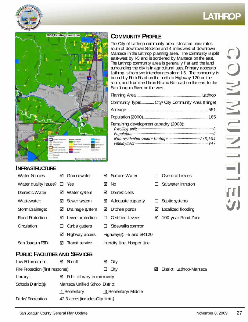
COMMUNITY PROFILE The City of Lathrop community area is located nine miles south of downtown Stockton and 4 miles west of downtown Manteca in the Lathrop planning area. The community is split east-west by I-5 and is bordered by Manteca on the east. The Lathrop community area is generally flat and the land surrounding the city is in agricultural uses. Primary access to Lathrop is from two interchanges along I-5. The community is bound by Roth Road on the north to Highway 120 on the south, and from the Union Pacific Railroad on the east to the San Joaquin River on the west.
Planning Area ................................................................... Lathrop
Community Type: ............. City/City Community Area (fringe)
Acreage .................................................................................... 551
Population (2000) ................................................................... 185
Remaining development capacity (2008): Dwelling units ············································································· 0 Population ··················································································· 0 Non-residential square footage ································ 778,684 Employment ··········································································· 947
INFRASTRUCTURE Water Sources: Groundwater Surface Water Overdraft issues
Water quality issues? Yes No Saltwater intrusion
Domestic Water: Water system Domestic ells
Wastewater: Sewer system Adequate capacity Septic systems
Storm Drainage: Drainage system Ditches/ponds Localized flooding
Flood Protection: Levee protection Certified Levees 100-year Flood Zone
Circulation: Curbs/gutters Sidewalks common
Highway access Highway(s): I-5 and SR 120
San Joaquin RTD: Transit service Intercity Line, Hopper Line
PUBLIC FACILITIES AND SERVICES Law Enforcement: Sheriff City
Fire Protection (first response): City District: Lathrop-Manteca
Library: Public library in community
Schools District(s): Manteca Unified School District
1 Elementary 3 Elementary/Middle
Parks/Recreation: 42.3 acres (includes City limits)
28 November 8, 2009 San Joaquin County General Plan Update
CO
MM
UN
ITIE
S COMMUNITY PROFILE
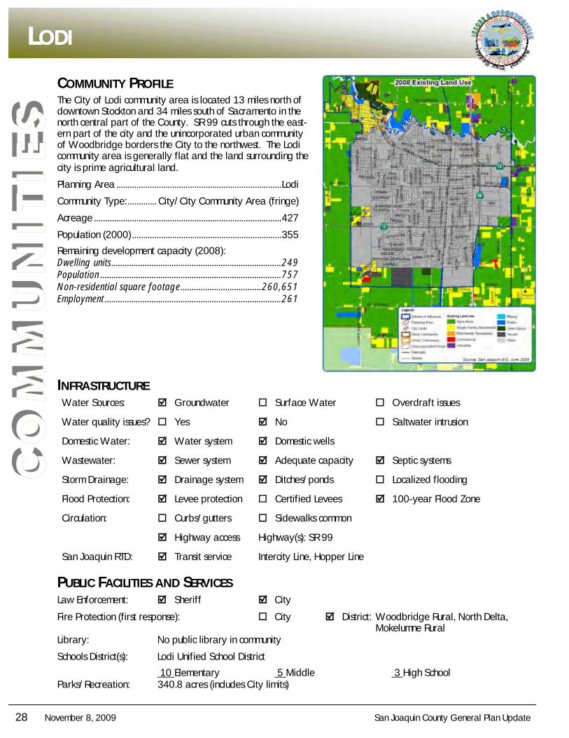
The City of Lodi community area is located 13 miles north of downtown Stockton and 34 miles south of Sacramento in the north central part of the County. SR 99 cuts through the east-ern part of the city and the unincorporated urban community of Woodbridge borders the City to the northwest. The Lodi community area is generally flat and the land surrounding the city is prime agricultural land.
Planning Area .......................................................................... Lodi
Community Type: ............. City/City Community Area (fringe)
Acreage .................................................................................... 427
Population (2000) ................................................................... 355
Remaining development capacity (2008): Dwelling units ............................................................................ 249 Population ................................................................................. 757 Non-residential square footage .................................... 260,651 Employment ............................................................................... 261
INFRASTRUCTURE Water Sources: Groundwater Surface Water Overdraft issues
Water quality issues? Yes No Saltwater intrusion
Domestic Water: Water system Domestic wells
Wastewater: Sewer system Adequate capacity Septic systems
Storm Drainage: Drainage system Ditches/ponds Localized flooding
Flood Protection: Levee protection Certified Levees 100-year Flood Zone
Circulation: Curbs/gutters Sidewalks common
Highway access Highway(s): SR 99
San Joaquin RTD: Transit service Intercity Line, Hopper Line
PUBLIC FACILITIES AND SERVICES Law Enforcement: Sheriff City
Fire Protection (first response): City District: Woodbridge Rural, North Delta, Mokelumne Rural Library: No public library in community
Schools District(s): Lodi Unified School District
10 Elementary 5 Middle 3 High School Parks/Recreation: 340.8 acres (includes City limits)
LLLODIODIODI
San Joaquin County General Plan Update November 8, 2009 29
CO
MM
UN
ITIE
S
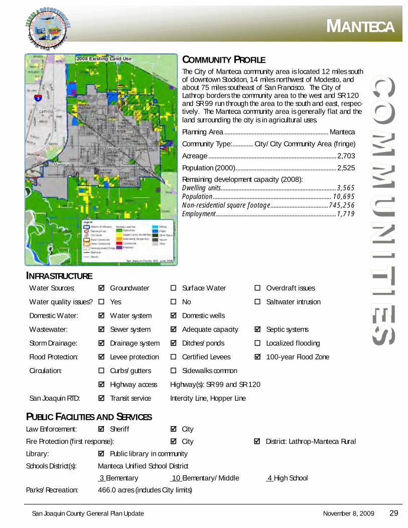
MMMANTECAANTECAANTECA
COMMUNITY PROFILE The City of Manteca community area is located 12 miles south of downtown Stockton, 14 miles northwest of Modesto, and about 75 miles southeast of San Francisco. The City of Lathrop borders the community area to the west and SR 120 and SR 99 run through the area to the south and east, respec-tively. The Manteca community area is generally flat and the land surrounding the city is in agricultural uses.
Planning Area ................................................................. Manteca
Community Type: ............. City/City Community Area (fringe)
Acreage ................................................................................ 2,703
Population (2000) ............................................................... 2,525
Remaining development capacity (2008): Dwelling units ........................................................................ 3,565 Population .......................................................................... 10,695 Non-residential square footage .................................... 745,256 Employment ........................................................................... 1,719
INFRASTRUCTURE Water Sources: Groundwater Surface Water Overdraft issues
Water quality issues? Yes No Saltwater intrusion
Domestic Water: Water system Domestic wells
Wastewater: Sewer system Adequate capacity Septic systems
Storm Drainage: Drainage system Ditches/ponds Localized flooding
Flood Protection: Levee protection Certified Levees 100-year Flood Zone
Circulation: Curbs/gutters Sidewalks common
Highway access Highway(s): SR 99 and SR 120
San Joaquin RTD: Transit service Intercity Line, Hopper Line
PUBLIC FACILITIES AND SERVICES Law Enforcement: Sheriff City
Fire Protection (first response): City District: Lathrop-Manteca Rural
Library: Public library in community
Schools District(s): Manteca Unified School District
3 Elementary 10 Elementary/Middle 4 High School
Parks/Recreation: 466.0 acres (includes City limits)
30 November 8, 2009 San Joaquin County General Plan Update
CO
MM
UN
ITIE
S COMMUNITY PROFILE
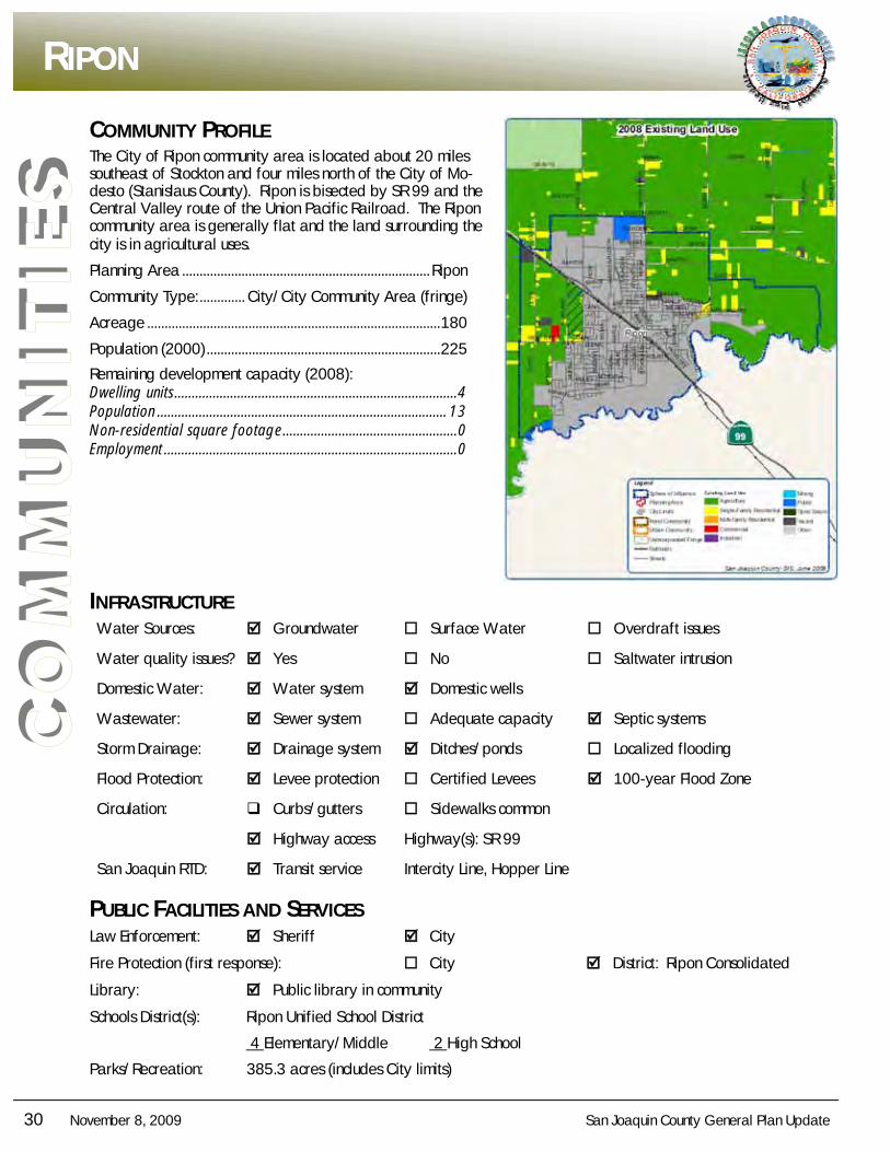
The City of Ripon community area is located about 20 miles southeast of Stockton and four miles north of the City of Mo-desto (Stanislaus County). Ripon is bisected by SR 99 and the Central Valley route of the Union Pacific Railroad. The Ripon community area is generally flat and the land surrounding the city is in agricultural uses.
Planning Area ....................................................................... Ripon
Community Type: ............. City/City Community Area (fringe)
Acreage .................................................................................... 180
Population (2000) ................................................................... 225
Remaining development capacity (2008): Dwelling units ................................................................................. 4 Population ................................................................................... 13 Non-residential square footage .................................................. 0 Employment .................................................................................... 0
INFRASTRUCTURE Water Sources: Groundwater Surface Water Overdraft issues
Water quality issues? Yes No Saltwater intrusion
Domestic Water: Water system Domestic wells
Wastewater: Sewer system Adequate capacity Septic systems
Storm Drainage: Drainage system Ditches/ponds Localized flooding
Flood Protection: Levee protection Certified Levees 100-year Flood Zone
Circulation: Curbs/gutters Sidewalks common
Highway access Highway(s): SR 99
San Joaquin RTD: Transit service Intercity Line, Hopper Line
PUBLIC FACILITIES AND SERVICES Law Enforcement: Sheriff City
Fire Protection (first response): City District: Ripon Consolidated
Library: Public library in community
Schools District(s): Ripon Unified School District
4 Elementary/Middle 2 High School
Parks/Recreation: 385.3 acres (includes City limits)
RRRIPONIPONIPON
San Joaquin County General Plan Update November 8, 2009 31
CO
MM
UN
ITIE
S
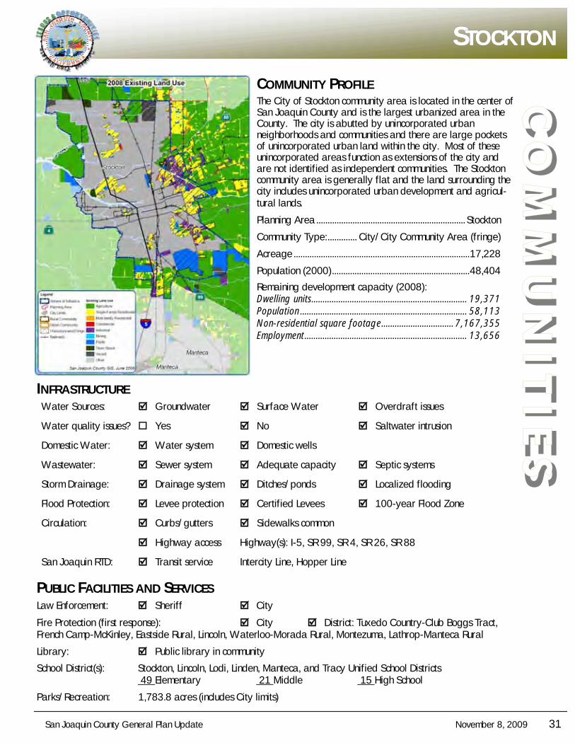
SSSTOCKTONTOCKTONTOCKTON
COMMUNITY PROFILE The City of Stockton community area is located in the center of San Joaquin County and is the largest urbanized area in the County. The city is abutted by unincorporated urban neighborhoods and communities and there are large pockets of unincorporated urban land within the city. Most of these unincorporated areas function as extensions of the city and are not identified as independent communities. The Stockton community area is generally flat and the land surrounding the city includes unincorporated urban development and agricul-tural lands.
Planning Area .................................................................. Stockton
Community Type: ............. City/City Community Area (fringe)
Acreage .............................................................................. 17,228
Population (2000) ............................................................. 48,404
Remaining development capacity (2008): Dwelling units ..................................................................... 19,371 Population .......................................................................... 58,113 Non-residential square footage ................................ 7,167,355 Employment ........................................................................ 13,656
INFRASTRUCTURE Water Sources: Groundwater Surface Water Overdraft issues
Water quality issues? Yes No Saltwater intrusion
Domestic Water: Water system Domestic wells
Wastewater: Sewer system Adequate capacity Septic systems
Storm Drainage: Drainage system Ditches/ponds Localized flooding
Flood Protection: Levee protection Certified Levees 100-year Flood Zone
Circulation: Curbs/gutters Sidewalks common
Highway access Highway(s): I-5, SR 99, SR 4, SR 26, SR 88
San Joaquin RTD: Transit service Intercity Line, Hopper Line
PUBLIC FACILITIES AND SERVICES Law Enforcement: Sheriff City
Fire Protection (first response): City District: Tuxedo Country-Club Boggs Tract, French Camp-McKinley, Eastside Rural, Lincoln, Waterloo-Morada Rural, Montezuma, Lathrop-Manteca Rural
Library: Public library in community
School District(s): Stockton, Lincoln, Lodi, Linden, Manteca, and Tracy Unified School Districts 49 Elementary 21 Middle 15 High School
Parks/Recreation: 1,783.8 acres (includes City limits)
32 November 8, 2009 San Joaquin County General Plan Update
CO
MM
UN
ITIE
S COMMUNITY PROFILE
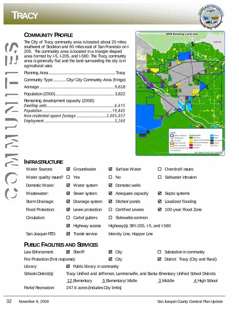
The City of Tracy community area is located about 20 miles southwest of Stockton and 60 miles east of San Francisco on I-205. The community area is located in a triangle shaped area formed by I-5, I-205, and I-580. The Tracy community area is generally flat and the land surrounding the city is in agricultural uses.
Planning Area ....................................................................... Tracy
Community Type: ............. City/City Community Area (fringe)
Acreage ................................................................................ 5,618
Population (2000) ............................................................... 3,822
Remaining development capacity (2008): Dwelling units ........................................................................ 6,615 Population .......................................................................... 19,845 Non-residential square footage ................................ 2,005,037 Employment ........................................................................... 3,260
INFRASTRUCTURE Water Sources: Groundwater Surface Water Overdraft issues
Water quality issues? Yes No Saltwater intrusion
Domestic Water: Water system Domestic wells
Wastewater: Sewer system Adequate capacity Septic systems
Storm Drainage: Drainage system Ditches/ponds Localized flooding
Flood Protection: Levee protection Certified Levees 100-year Flood Zone
Circulation: Curbs/gutters Sidewalks common
Highway access Highway(s): SR I-205, I-5, and I-580
San Joaquin RTD: Transit service Intercity Line, Hopper Line
PUBLIC FACILITIES AND SERVICES Law Enforcement: Sheriff City Substation in community
Fire Protection (first response): City District: Tracy (City and Rural)
Library: Public library in community
Schools District(s): Tracy Unified and Jefferson, Lammersville, and Banta Elmentary Unified School Districts
12 Elementary 5 Elementary/Midle 3 Middle 4 High School
Parks/Recreation: 247.6 acres (includes City limits)
TTTRACYRACYRACY