Embed Size (px)
Citation preview
BADIL
for Palestinian Residency and Refugee RightsResource Center
بـديـــــل
والـالجئيـن المواطنـة لمصـادر حقـوق
المركز الفلسطيني
July 2019
IsraelI annexatIon:The Case of
Etzion Colonial BloC
BADIL has consultative status with UN ECOSOC
BADIL
for Palestinian Residency and Refugee RightsResource Center
بـديـــــل
ملصـادر حقـــوق املواطنـة والـالجئيـن
املركز الفلسطيني
Etzion Colonial BloC
July 2019
IsraelI annexatIon:
In conclusion, the manageable realization of de jure annexation is inextricably tied to the establishment of an apartheid state that can dominate and isolate the Palestinian population. In other words, under the guise of occupation, Israel has clearly achieved de facto annexation of large areas, and is evolving its strategy into creeping de jure annexation, underpinned by apartheid. With Israel’s effective control over the occupied territory, the urgency for third party states to act and fulfil their obligations has never been more demanding. The question thus remains of how long and intensely Israel will continue its annexation attempts and apartheid rule of a steadfast and perseverant Palestinian people before duty bearers intervene to fulfill their obligations to uphold the rights of the Palestinian people in accordance with international law.
The Case of
BADIL has consultative status with UN ECOSOC
BADIL
Israeli Annexation: The Case of Etzion Colonial Bloc
Lead Researcher: Melissa Yvonne
Editor: Lubnah Shomali
Desk Researchers: Amaya al-Orzza, Alice Osbourne, Martina Ramacciotti, Shaina Rose Low, Elsa Koehler
and Layla Allen
Field researchers: Mohammad Abu Srour, Lana Ramadan, Myriam Abu Laban, and Walaa Shahin
Copy Edit: Layla Allen, Melissa Yvonne, Sarah el-Alam
Design and Layout: Atallah Salem
ISBN: 978-9950-339-41-5
All rights reserved
© BADIL Resource Center for Palestinian Residency and Refugee Rights
Israeli Annexation: The Case of Etzion Colonial Bloc
July 2019
Credit and Notations
This particular research has been created over the last three years, under a continuous learning process and through the efforts of multiple research teams. While BADIL did its best to acknowledge all who contributed to its long and sporadic development, some contributions may have been omitted during the editing process and therefore some contributors are not included in the credits. BADIL sincerely thanks all those who have supported this research project and in particular, the data collection team comprised of 19 persons, consisting of 17 female data collectors and all the interview partners who provided the critical evidential and testimonial components.
Any quotation of up to 500 words may be used without permission provided that full attribution is given. Longer quotations, entire chapters or sections of this study may not be reproduced or transmitted in any form or by any means, without the express written permission of BADIL Resource Center for Palestinian Residency and Refugee Rights.
BADIL Resource Center for Palestinian Residency and Refugee Rights
Karkafa St.
PO Box 728, Bethlehem, West Bank; Palestine
Tel.: +970-2-277-7086; Fax: +970-2-274-7346
Website: www.badil.org
BADIL Resource Center for Palestinian Residency and Refugee Rights is independent, human rights non-profit organization working to defend and promote the rights of Palestinian refugees and Internally Displaced Persons (IDPs). Our vision, mission, programs and relationships are defined by our Palestinian identity and the principles of international humanitarian and human rights law. We seek to advance the individual and collective rights of the Palestinian people on this basis.
Table of ContentsExecutive Summary
1. Introduction – Why the Etzion Colonial Bloc?1.1. DefiningtheEtzionColonialBloc1.2. ResearchMethodology
2. The Guise of Occupation2.1. LegalFramework:Occupation2.2. BelligerentOccupationofPalestinianTerritory
3. Colonialism: Maximum Amount of Land, with Maximum Israeli-Jews
3.1. LegalFramework:Colonialism3.2. EstablishmentandExpansionoftheEtzionColonialBloc3.3. EntrenchmentandConsolidationoftheEtzionColonialBloc
4. Forcible Population Transfer: Minimum Palestinians4.1. LegalFramework:ForcibleTransfer4.2. TheExperienceofForcibleTransferPoliciesattheEpicenterofEtzion4.3. TheExperienceofForcibleTransferPoliciesontheOutskirtsofEtzion
5. Annexation of the Etzion Colonial Bloc5.1. LegalFramework:Annexation5.2. TheIsraeliIntenttoAnnextheEtzionColonialBloc5.3. ExtensionofIsraeliSovereigntyintotheoPt5.4. Israeli-JewishFactsontheGroundIndicatingPermanence
6. Third State Obligations6.1. ObligationsunderLawofStateResponsibility6.2. ObligationsunderInternationalHumanitarianLaw6.3. ObligationsunderInternationalCriminalLaw
7. Findings: Creeping de jure Annexation and One Apartheid State
7.1. Creepingde jureAnnexation7.2. AStateofApartheid
8. RecommendationsAnnex 1 – List of the Colonies of the Etzion Colonial Bloc Annex 2 – Photo Exhibition
4
913
16
20 21
23
25
26
28
46
62 62
65
95
114 114
119
127
129
133 133
136
137
139
141
145
148
150 154
List of TablesTable1: PalestinianvillagessurveyedbyBADILTable2: LandstatusofinitialEtzioncoloniesTable3: StatusofunauthorizedoutpostsintheEtzionColonialBlocTable4: PercentageofPalestiniansthreatenedbyforcibletransferpoliciesinthe
Etzionepicenter(Top6)Table5: ComplaintsaboutIsraelipoliciesTable6: PercentageofPalestinianssurveyedinEtzionepicenterwhoexperiencea
lackofservicesTable7: ComplaintsaboutserviceprovisionTable8: Top6forcibletransferpoliciesthreateningPalestiniansintheareaofeastern
expansionTable9: Top6ForcibletransferpoliciesthreateningPalestiniansintheareaof
southernexpansionTable10:Populationcomparison
List of GraphsGraph1: TimelineofcolonizationintheEtzionColonialBlocGraph2: PercentageofpopulationchangesinEtzioncolonies,byyearGraph3: CorrelationbetweenemploymentinagricultureandIsraelilabormarketfor
villagesintheepicenterofEtzionColonialBlocGraph4: Byarea,percentageofpeopleexperiencingverysevereimpactoncapacity
toremaininvillageduetolackofservicesGraph5: AlWalaja-Numberofstructuresdemolished2009-2019Graph6: BeitSakarya-Homedemolitionordersissuedperyear(Jan.1988-Apr.2017)Graph7: AlKhader-Demolitionordersissuedperyear(Jan.1988-Apr.2017)Graph8: PercentageofsurveyedpeoplefeelingthreatofIsraeliPoliciesofforcible
transfer-inPalestinianvillagesintheareaofeasternexpansion.Graph9: Israelipoliciesofforcibletransferandthelevelofthreat-intherural
PalestiniantownsimmediatelysouthofEtzion.Graph10:UmmSalamuna-DemolitionordersIssuedPerYear(Jan.1988-Apr.2017)
List of MapsMap1: AreaoftheEtzionColonialBloc,2018Map2: MapoftheMasterPlanforMetropolitanJerusalem,showingplannedroad
network,1982Map3: SatelliteimageofAlWalaja.Map4: SatelliteimageofBeitSakaryaandsurroundingcolonies.Map5: JerusalemMasterPlan,1968Map6: MetropolitanandGreaterJerusalem,1997.
173245 65
66 68
69 95
98
99
3851 67
68
72 81 8596
100
108
15 54
71 78
121121
5
Executive Summary
After east Jerusalem, the Etzion Colonial Bloc is the most advanced example of the mechanisms Israel deploys throughout the West Bank, in order to acquire sovereignty over Palestinian land and confine the Palestinian population to discrete pockets of existence, a form of Palestinian Bantustan. For this reason, BADIL has chosen to focus its research on the Etzion Colonial Bloc as a case study to illustrate concretely the Israeli process of colonization, forcible population transfer leading to annexation of what remains of Palestinian land, and ultimately apartheid. This paper pulls together extensive research already undertaken by BADIL and others on individual aspects of Israeli policies, to show the way in which these policies are employed as a whole, to effect the ultimate Zionist objective of maximum amount of land with the minimum number of Palestinians in the whole of Mandatory Palestine.
From a Palestinian point-of-view, Etzion is an entirely artificial creation imposed on them. It is a product of Israeli policies to control and manipulate demography, land and resources that affects, disturbs and obliterates Palestinian life in it. It also contributes to the erasure of the Palestinian indigeneity and connection to the area in local and international consciousness, which is facilitating Israeli annexation and is also reflected across the West Bank.
This case study defines the Etzion Colonial Bloc as a group of approximately 45 colonies, including the so-called outposts, located primarily south of Jerusalem, containing more than 87,100 colonizers. This area being swallowed by the bloc is home to more than 50 Palestinian villages and towns, and some 200,000 Palestinians. The resulting case study and analysis was developed utilizing both primary research – in the form of a survey administered to 1,001 randomly selected Palestinian participants residing in the area over a ten day period during May 2018 – and legal and existing literature review and analysis. In addition to the survey, the paper contains: four case studies on the establishment of settler-colonies; case studies of seven Palestinian
6
villages within the bloc highlighting the experience of forcible transfer; 14 semi-structured interviews with multiple sectors of Palestinian civil society and victims of the Israeli forcible transfer policies.
In Chapter 2, this paper introduces the Israeli strategy, which operates under the guise of occupation, a state of affairs technically permissible under international law, before focusing on the two pillars of the strategy. First, to acquire the maximum amount of land with maximum Israeli-Jews, a chapter which details the Israeli deployment of colonial practices in the Etzion Colonial Bloc. Second, to do so with the minimum number of Palestinians, a chapter which outlines the lived impact of Israel’s policies of forcible transfer on the Palestinian population in the Etzion Colonial Bloc. The culmination of which is explored in the following chapter, namely the de facto annexation of territory, until the Palestinian population has diminished sufficiently to pave the way for de jure annexation.
Under the guise of occupation, Israel swiftly established and expanded the Etzion Colonial Bloc using a variety of mechanisms based on legislative misappropriation, which are explored in Chapter 3: confiscation based on supposed military necessity (nahals); designation and development of “state land”; tacit approval and support to unauthorized outposts; and ambiguous ‘survey’ land designations that facilitate the theft of private Palestinian land. As one mechanism reaches the limits of its utility, new mechanisms are crafted and deployed, each designed to create a façade of legality that circumvents both international and Israeli legal hurdles and administrative complications, in order to advance the project of colonial expansion.
Almost immediately, Israel beings an ongoing process of entrenching and solidifying its hold on these areas by: establishing bureaucratic structures such as the Gush Etzion Regional Council; increasing the Israel-Jewish settler-colonial population; reconfiguring the transportation infrastructure to facilitate the movement of the colonizers across the Green Line; engaging in economic domination and the exploitation of natural resources; and creating continuity between the key colonies and newly established outlier colonies and outposts.
While colonizing the land, Israel has also implemented a range of policies aimed at altering demographics and forcibly transferring Palestinians who live there, which are detailed in Chapter 4. Whilst forcible transfer is not a necessary pre-condition for annexation, it is a key mechanism utilized by Israel to both free up land for acquisition and assertion of sovereignty, and to
7
engineer the necessary and desired demographic majority. To this end, the implemented survey analyzes the extent to which Palestinians in the area are exposed to the nine Israeli policies that create a coercive environment and induce the forcible transfer of Palestinians out of the area.
Finally, in Chapters 5 to 7, the paper comprehensively examines and details the situation in the West Bank vis-a-vis annexation (territorial acquisition by force), which constitutes a violation of peremptory norm of international law, and the progression of Israeli annexation from de facto to de jure. Evidence of de facto annexation is proven by reference to the policies and actions of the Occupying Power (OP) towards the occupied territory so as to establish implicit intent to permanently acquire territory. The level of intent is measured by: official plans, policies and comments; the extension of sovereignty to the territory in the form of domestic laws; and the installation of facts on the ground which indicate a situation of permanence and sovereignty. In the epicenter of the Etzion Colonial Bloc, Israel has met and exceeded all three aforementioned criteria. This has been so effective that the intention and actions of Israel with respect to large expanses of the oPt are increasingly understood by international actors and scholars as constituting de facto annexation. In other areas of the bloc, the advance towards de facto annexation continues unabated by international intervention. Virtually uninhibited by the Palestinian facts on the ground, Israel merely deploys the particular policy mechanisms that allow it to segregate, suppress and control these populations, so as to achieve further annexation by underpinning it with a system of apartheid.
On the other hand, the recognition in law that the territory belongs to that state is the essence of the distinction between de facto annexation and de jure annexation. Although in the past this might ordinarily have come as a formal declaration, international law is not specific as to the nature of the declaratory act required to distinguish a state of de facto and de jure annexation. Given the international consensus against annexation, Israel is simply laying the legal (and demographic) foundations for de jure annexation, such that formal declaration will merely be the final step in the process of annexation.
As part of the process of annexation, Israel established a convoluted legal system in the oPt that applies one legal framework to Israeli colonizers and another to Palestinians, while ostensibly maintaining the appearance of an occupied territory governed by separate military laws. The two-tier system created by these laws imposes a clear discriminatory regime favoring Israeli
8
colonizers and whilst denying the right to self-determination for Palestinians. Until recently, the complex and opaque mechanism by which this apartheid situation was created, had maintained the legal distinction with regards to the status of this territory through extension of laws to the colonizers themselves as Israeli citizens or Israel’s insistence on military orders being utilized to enable the extension of jurisdiction.
However, Israel has been increasingly bypassing this charade and has taken formal actions to dismantle the legal distinctions between the occupied West Bank and Israel, which indicate a clear sense of permanence to the situation Israel has manufactured. It is doing this through a series of de jure acts that have the effect of amending the law so that increasingly under the Israeli legal system, this territory is considered territory indistinguishable from the Israeli state over which Israeli sovereignty exists. The passage of Knesset laws which apply directly to the territory of the West Bank, the conferral on the lower administrative courts of Israel jurisdiction to determine cases originating in and concerning Palestinians in the West Bank, as well as the shift in legal jurisprudence from an increasingly conservative High Court Bench, all signal a shift towards de jure annexation of the West Bank, which is superseding the process of de facto annexation.
In the absence of factual supremacy on the ground that would be evidenced by total de facto annexation, the manageable realization of de jure annexation is inextricably tied to the establishment of an apartheid state which can dominate and isolate the Palestinian population. In other words, under the guise of occupation, Israel has clearly achieved de facto annexation of large areas, and is evolving its strategy into creeping de jure annexation, underpinned by apartheid, in order to acquire the whole of Mandatory Palestine. With Israel’s effective control over the occupied territory, the urgency for third party states to act and fulfil their obligations has never been more demanding. The question thus remains of how long and intensely Israel will continue its annexation attempts and apartheid rule of a steadfast and perseverant Palestinian people, before duty bearers intervene to fulfill their obligations to uphold the rights of the Palestinian people in accordance with international law.
9
1. Introduction – Why the Etzion Colonial Bloc?
The area of this case study has no proper Palestinian name; the most exact description identifiable is the northern region of the Al Khalil (Hebron) Mountains. For Palestinians, the area is not a homogenous coherent region; rather it overlaps, merges and dissects pre-existing communities, economies and districts. For example, pre-1948, the area predominately fell within the Hebron Governorate, with a few of the northern villages, including Bethlehem, forming part of the Jerusalem Governorate.1 Moreover, it is not typical of Palestinian culture or administrative practice to apply labels to large areas of land, instead, areas are known by the names of the specific villages and towns or in relation to a landmark close by.
Many of the Palestinian villages in the northern Hebron Mountains region can trace their roots to the Canaanite and Byzantine eras, with their modern-day manifestations dating back to the 1700s and 1800s, and all predating Israeli colonization of the area. For example, Husan is a village dating to the 3rd century, while Beit Fajjar is a town dating back to the Canaanite era, the present day name of which was conferred in the 7th century, with the modern town dating back to 1784.2 Until the 1967 occupation, water from this region had serviced Jerusalem for more than 2000 years. Known as “Qanat el-Sabil”, a network of largely underground aqueducts in this area, including the Wadi al-Biyar aqueduct, which is now an Israeli tourist attraction in the Etzion Colonial Bloc, connected to Solomon Pools in Artas village before continuing to Jerusalem.3 Also significant was a listing in 2014 of the village of Battir as a
1 Salman Abu-Sitta, “MAP: Palestine 1948. 50 Years After Al Nakba. The Towns and VillagesDepopulated by the Zionist Invasion of 1948”, Palestine Return Center, (London, May 1998).
2 The Applied Research Institute Jerusalem (ARIJ), “Beit Fajjar Town Profile”, The Palestinian Community Profiles and Needs Assessment, (2010):5,availableathttp://vprofile.arij.org/bethlehem/pdfs/VP/Beit%20Fajjar_tp_en.pdf
3 DimaSrouji,“Solomon’sPools:APatientFrameworkAwaitingItsPotential”,Jerusalem Quarterly 69,(2017):98-105,availableathttps://www.palestine-studies.org/sites/default/files/jq-articles/Pages%20from%20JQ%2069%20-%20Srouji.pdf;HydriaProject,“Solomon’sPoolsandrelatingaqueducts,theheartofJerusalem’spastwatersupply”,2009,availableathttp://www.hydriaproject.info/en/palestine-solomons-pools/waterworks25/[bothaccessed20June2019].
10
UNESCO World Heritage site, due to the village’s 4000 year old terrace system for land cultivation.4
Following the Nakba of 1948, the population of the region changed dramatically due to forcible displacement. Many of the original Palestinian population there became refugees elsewhere, whether in Shufat camp in Jerusalem, Dheisheh camp in Bethlehem or in Lebanon or Jordan. Palestinians west of the Green Line were forcibly displaced from their original villages into villages in this region. In the case of villages such as Wadi Fukin, Al Walaja and Battir, more than 75 percent of their respective populations are registered refugees with the United Nations Relief and Works Agency for Palestine Refugees in the Near East (UNRWA), with much of their original villages lying on the western side of the Green Line.5
Today, following the signing of the Oslo Accords in 1995, most of this area is allocated to the Bethlehem Governorate, with the towns south of Beit Fajjar, falling in the Hebron Governorate. Regardless, this area is home to more than 50 Palestinian villages and towns, and some 200,000 Palestinians.6 These towns and villages are fundamental to the socio-economic ecosystems of Bethlehem and Hebron, two significant and sizable Palestinian cities. Approximately 26,000 Palestinians live in the area specifically located to the west of the Apartheid Wall (the Wall) as currently planned, an area we analyze throughout this paper as the “epicenter” of the Etzion Colonial Bloc. Whilst a further 52,000 Palestinians live in the towns, villages and hamlets that lie directly south of Bethlehem, being the area we analyze as being affected by the “eastern expansion” of the Etzion Colonial Bloc.7
4 United Nations Educational, Scientific and Cultural Organization (UNESCO),Palestine: Land of Olives and Vines. Cultural Landscape of Southern Jerusalem, Battir,WorldHeritageSiteNominationDocument, 2014, available at https://whc.unesco.org/document/167419 [accessed 20 June 2019].
5 UNWRA, “Western BethlehemVillages,West Bank: Refugee Communities in the ‘Gush Etzion’SettlementArea (Infographic)”,2015, availableat https://www.unrwa.org/sites/default/files/content/resources/gush_etzion_2015_final_approved_by_duo.pdf [hereinafter UNWRA, Gush EtzionInfographic].
6 This includesAlWalaja, Battir, Husan,Wadi Fukin, Nahhalin,Al Jaba’, Khallet al Balluta, BeitSakaryaandKhalletA’fana,butdoesnotincludetheareasandresidentsofBeitJalaandAlKhaderwhoselandand/orpropertiesmayalsoliewestoftheproposedorexistingApartheidWall(theWall).See:PalestinianCentralBureauofStatistics(PCBS),Preliminary Results of the Population, Housing and Establishments Census, 2017,February2018,76-78,availableathttp://www.pcbs.gov.ps/portals/_pcbs/PressRelease/Press_En_Preliminary_Results_Report-en-with-tables.pdf [hereinafter PCBS,Census 2017].
7 ThisincludesArtas,KhalletalLouza,AlFureidis,Jannatah,WadiRahhal,JubadhDhib,KhalletalHaddad,AlMa’sara,WadianNis,KhirbetadDeir,JuratashShama’a,MarahMa’alla,AlHalqum,UmmSalamuna,AlManshiya,Tuqu’,MarahRabah,Wadi Immhamid,KhirbetTuqu’,BeitFajjar,Kisan–SeePCBS,Census2017, supra note 6, 76-77.
11
This study demonstrates how the area and its Palestinian population are being slowly suffocated and isolated by Israel’s policies of colonialism, forcible population transfer and annexation. More specifically, Bethlehem is encircled to the north, west, south, south-east and north-east, by approximately 45 colonies, including so-called outposts,8 which together make up the Etzion Colonial Bloc. These colonies and their infrastructure are swallowing up the surrounding Palestinian villages that once formed the breadbasket of Bethlehem. Consequently, the Palestinian populations are forced into Bethlehem and Hebron, where space is scarce. Particularly, in the case of Bethlehem, its natural growth is already severely impeded by Israel’s colonial enterprise.
After east Jerusalem, the Etzion Colonial Bloc is the most advanced example of the mechanisms Israel deploys throughout the West Bank, in order to acquire sovereignty over Palestinian land and confine the Palestinian population to discrete pockets of existence, a form of Palestinian Bantustan.9 For this reason, BADIL has chosen to focus its research on the Etzion Colonial Bloc as a case study to illustrate concretely the Israeli process of colonization, forcible population transfer leading to annexation of what remains of Palestinian land, and ultimately apartheid. This paper pulls together extensive research already undertaken by BADIL and others on individual aspects of Israeli policies to show the way in which these policies are employed as a whole to effect the ultimate Zionist objective of a maximum amount of land with the minimum number of Palestinians in the whole of Mandatory Palestine.
The Etzion Colonial Bloc is a critical element of Israeli plans for Greater Jerusalem, and its objectives to create an Israeli-Jewish majority, in order to establish Israeli sovereignty to the unified city of Jerusalem. Prior to this, Gush Etzion was crafted into a foundational piece of Israeli nationhood. Indeed, a small section of the area that now makes up the Etzion Colonial Bloc was the subject of three short-lived Jewish colonization attempts prior to the creation
8 OutpostsarecoloniesbuiltwithoutofficialauthorizationoftheIsraeliGovernment,butnonethelesswith their tacit support -manyofwhichare in theprocessofbeing“legalized.”
9 BantustanswereestablishedbytheApartheidSouthAfricanGovernment,asareastowhichthemajorityoftheBlackpopulationwasmovedtopreventthemfromlivingintheurbanareasofSouthAfrica.TheBantustanswereamajoradministrativemechanismfortheremovalofBlacksfromtheSouthAfricanpoliticalsystemunderthelawsandpoliciescreatedbyApartheid.SeeSouthAfricanHistoryOnline,The Homelands,17April2011,availableathttps://www.sahistory.org.za/article/homelands[accessed20June2019].
12
of Israel in 1948.10 Yet, Etzion has come to form an integral part of the Israeli nationhood myth, and is seen as an indistinguishable part of the Israeli state.11 This mythology has been utilized repeatedly by Israeli leaders to both justify the colonial and annexation project in this particular area and to set the tone for the entire colonial enterprise in the West Bank.
From a Palestinian point-of-view, Etzion is an entirely artificial creation imposed on them. It is a product of Israeli policies to control and manipulate demography, land and resources that affects, disturbs and obliterates Palestinian life in it. It also contributes to the erasure of the Palestinian indigeneity and connection to the area in local and international consciousness, which is facilitating Israeli annexation and is also reflected across the West Bank.
To this end, what is happening to Bethlehem is by no means unique to the Palestinian situation. The pattern is repeated in the other ever-expanding Colonial Blocs. The precise number of these blocs is deliberately unclear, but generally refers to Ma’ale Adumim and its expansion to E1, Giv’at Ze’ev, Modi’in Illit, Shaked in the north, and the so-called Fingers bloc, which refers to the merging of Karnei Shomron, Ariel and Kedumim blocs.12 Misleadingly, a number of these blocs are referred to in Israeli circles as “consensus” blocs in which it is understood that these areas will be included in the permanent borders of the Israeli state.13 Though much of these blocs fall outside boundaries proposed during peace negotiations thus far, the significant investment and expansion evident in these Colonial Blocs since negotiations
10 JohnC.LehrandYossiKatz,“HeritageInterpretationandPoliticsinKfarEtzion,Israel”, International Journal of Heritage Studies9,no.3(2003):217[hereinafterLehrandKatz,PoliticsinKfarEtzion];Michal Oren-Nordheim and Ruth Kark, Jerusalem and Its Environs: Quarters, Neighborhoods, Villages, 1800-1948,(Jerusalem:TheHebrewUniversityMagnesPress,2001),338; YossiKatzandJohnC.Lehr,“SymbolismandLandscape:TheEtzionBlocinJudeanMountains”,Middle Eastern Studies31,no.4(1995):731.[hereinafterKatzandJohnSymbolismandLandscape].
11 LehrandKatz,PoliticsinKfarEtzion,supra note10,219-220;andDavidOhana,“KfarEtzion:TheCommunityofMemoryandtheMythofReturn”,Israel Studies 7,no.1(2002):145-174,availableat https://muse.jhu.edu/article/14502/summary [hereinafter Ohana, Kfar Etzion] [accessed 20 June2019].
12 BenWhite,“WhyIsraelinventedtheconceptof‘settlementblocs”,Middle East Eye,25January2016,available at https://www.middleeasteye.net/opinion/why-israel-invented-concept-settlement-blocs [accessed20June2019].
13 JewishVirtual Library, “The ’Consensus’ Settlements”,American- Israeli Cooperative Enterprise, 2019, available at https://www.jewishvirtuallibrary.org/the-ldquo-consensus-rdquo-settlements [accessed 20 June 2019]; Joshua Mitnick, “Why the Israeli ‘consensus’ on settlements is not sosimple”,Christian Science Monitor, 13 September 2010, available at https://www.csmonitor.com/World/Middle-East/2010/0913/Why-the-Israeli-consensus-on-settlements-is-not-so-simple [accessed20 June 2019].
13
broke down in 2008 is consistent with two objectives; a pragmatic objective to consolidate claims of Israeli sovereignty over these blocs to ensure their position in any two-state solution, and a longer-term objective to assert Israeli sovereignty over sufficient areas of the West Bank to bring an end to any prospect of a two-state solution.
This paper introduces the Israeli strategy, which operates under the guise of occupation, a state of affairs technically permissible under international law, before focusing on the two pillars of the strategy. First, to acquire the maximum amount of land with maximum Israeli-Jews, a chapter which details the Israeli deployment of colonial practices in the Etzion Colonial Bloc from 1967 to today. Second, to do so with the minimum number of Palestinians, a chapter which outlines the lived impact of Israel’s policies of forcible transfer on the Palestinian population in the Etzion Colonial Bloc. The culmination of which is explored in the following chapter, namely the de facto annexation of territory, until the Palestinian population has diminished sufficiently to pave the way for de jure annexation.
To understand what is happening throughout the bloc, the paper looks at the way in which these colonial and forcible transfer policies have been employed in the epicenter of the Etzion Colonial Bloc to effectuate de facto annexation, and are moving towards de jure annexation. It also considers the way these practices and policies are being deployed in the areas of expansion to the east and south, where the process of de facto annexation is underway. Finally, the paper will consider the responsibilities of Third States to hold Israel accountable for its illegal acts and to fulfill their obligations to uphold the rights of the Palestinian people.
1.1 Defining the Etzion Colonial Bloc
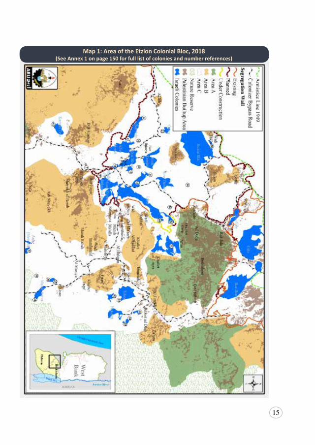
This case study defines the Etzion Colonial Bloc as a group of approximately 45 colonies, including the so-called outposts, located primarily south of Jerusalem, containing more than 87,100 colonizers (see Annexure 1).14 Each of the colonies are strategically located on hilltops, along major arterial roads and for the purpose of claiming land, as was consistent with some of the
14 DatacollatedfromthewebsiteoftheIsraeliGovernment’sCentralBureauofStatistics.Itisunclearwhether figures include the population living in outposts, as some have been formally recognizedas neighborhoods of nearby colonies, and others may just be considered extensions of nearbycolonies. See Population, Israeli Central Bureau of Statistics (ICBS), 2017, http://www.cbs.gov.il/reader/?MIval=cw_usr_view_SHTML&ID=807 [accessed 20 June 2019] [hereinafter ICBS,Population 2017].
14
early Zionist colonial plans for the West Bank:
“SettlementthroughouttheentireLandofIsraelisforsecurityandbyright[…]implemented according to a settlement policy of blocs of settlements inhomogenoussettlementareas.[…]Thedispositionofthesettlementsmustbecarriedoutnotonlyaroundthesettlementsoftheminorities,butalsoin between them[…].Overthecourseoftime,withorwithoutpeace,wewillhavetolearntolivewiththeminoritiesandamong them,[…]thereforetheproposedsettlementblocsaresituatedasastripsurroundingthe(Judea&Samaria)15ridge–startingfromitswesternslopesfromnorthtosouth,andalongitseasternslopesfromsouthtonorth:bothbetweentheminoritiespopulationandaroundit”.
Master Plan for the Development of Settlement in Judea and Samaria, 1979-1983 (emphasis in the original).
Consistent with this plan, just over half of the colonies are located in the area more habitually referred to as Gush Etzion, to the west and south west of Bethlehem, a location which separates Jerusalem from the southern West Bank and runs along the western slopes of the Hebron Mountains. Almost all of those colonies will be located on the western side of the Wall, which, in this area, will intrude substantially beyond the Green Line into occupied Palestinian territory (oPt). The other half of the colonies are scattered predominately along the hilltops to the east and south east of Bethlehem, in what is often called the Eastern Etzion Bloc. These are colonies that Israel is slowly connecting to the other colonies of Etzion and Jerusalem through additional land confiscations, colony construction, roads and other infrastructure, so that more recently, these colonies are also simply understood to be Gush Etzion, although they are a long way from the original area.
The largest colonies in the bloc – Beitar Illit, an ultra-orthodox colony with the second highest birth rate of any Israeli area,16 and Efrat – are governed as independent municipalities, while another 24 colonies, including unauthorized outposts, are administered by the Gush Etzion Regional Council as their own discrete communities. The remaining colonies are unauthorized outposts, but are largely governed under the existing structures of the Gush Etzion Regional Council, or Efrat Local Council in the case of Giv’at Hadagan, Giv’at Hatamar and Giv’at Eitam.
15 JudeaandSamariaaretheIsraelinamesfortheWestBank.16 “BirthrateinIsraelIncreases;ChareidimatHeadofthePack”,The Yeshiva World, 14March2018,
available at https://www.theyeshivaworld.com/news/israel-news/1488508/birthrate-in-israel-increases-charedim-at-head-of-the-pack.html [accessed 20 June 2019].
15
Map 1: Area of the Etzion Colonial Bloc, 2018(See Annex 1 on page 150 for full list of colonies and number references)
16
1.2 Research Methodology
The Palestinian communities located in and affected by the ever-expanding Etzion Colonial Bloc were identified early on as being at particular risk of forcible transfer. In 2015, BADIL carried out a Needs Assessment Survey of the Palestinian population in the Etzion Colonial Bloc seeking to more fully understand Israeli policies and practices in the area and to directly identify the best ways to assist these communities. BADIL sought to undertake desk research to understand the legal and policy frameworks within which the communities were living and surviving. The information available was alarmingly scarce and deliberately vague. As such, there was an urgent need to undertake primary research – in the form of a survey – in these communities to properly understand the dynamics playing out in these villages, the extent to which Israel’s policies of forcible transfer were being deployed and felt, and the capacity, if any, within communities to successfully resist these policies. This research paper is the culmination of that work and seeks to fill a gap in understanding as to how Israel utilizes Colonial Blocs to facilitate its creeping annexation of the West Bank, to understand the tipping point of de jure annexation, and to give a voice to the lived experiences of the Palestinian populations living there.
The survey, structured into seven sections, was administered to 1001 Palestinians (500 men and 501 women aged between 18 and 93) living in 24 villages directly affected by the bloc. The seven sections were delineated as follows: the first one focused on the personal information of the surveyed person; the second addressed the different policies of forcible transfer implemented by Israel in the area and the impact of such policies; the third included questions about the different actors operating in these localities; the fourth explored the availability of essential public services; the fifth asked those surveyed about their level of participation in public decision-making and projects; the sixth focused on policies of forcible transfer; and the last section addressed difficulties in the use of and access to land.
This survey engaged an experienced team of 13 data collectors and field researchers. The survey questionnaire was developed internally by BADIL, and piloted with a small group in Bethlehem to ensure language clarity, duration and the appropriateness of response options prior to its full implementation. The survey was then administered by the team to 1,001 randomly selected participants in the survey area over a ten day period during May 2018. The target group consisted of a representative sample based on Palestinian population size of localities there.
17
Confidentiality in undertaking this survey was of the upmost importance given the nature of the issues being discussed, and as such, no names were ever recorded and respondents were assured of the confidentiality of their answers. Female researchers were also employed to gather data from female respondents without interference of the male members of the household.
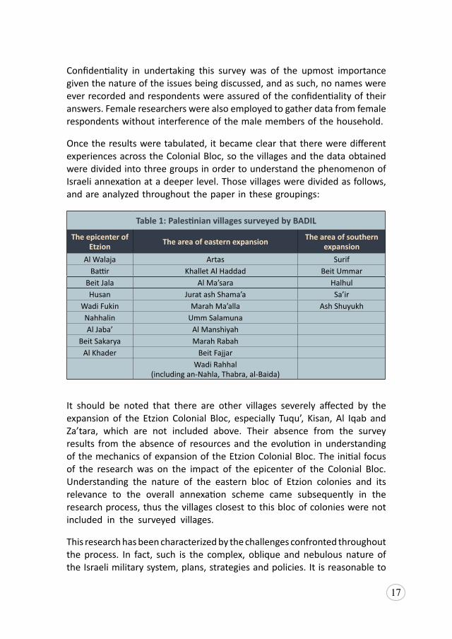
Once the results were tabulated, it became clear that there were different experiences across the Colonial Bloc, so the villages and the data obtained were divided into three groups in order to understand the phenomenon of Israeli annexation at a deeper level. Those villages were divided as follows, and are analyzed throughout the paper in these groupings:
Table 1: Palestinian villages surveyed by BADIL
The epicenter of Etzion The area of eastern expansion The area of southern
expansionAl Walaja Artas Surif
Battir Khallet Al Haddad Beit UmmarBeit Jala Al Ma’sara HalhulHusan Jurat ash Shama’a Sa’ir
Wadi Fukin Marah Ma’alla Ash ShuyukhNahhalin Umm SalamunaAl Jaba’ Al Manshiyah
Beit Sakarya Marah RabahAl Khader Beit Fajjar
Wadi Rahhal (including an-Nahla, Thabra, al-Baida)
It should be noted that there are other villages severely affected by the expansion of the Etzion Colonial Bloc, especially Tuqu’, Kisan, Al Iqab and Za’tara, which are not included above. Their absence from the survey results from the absence of resources and the evolution in understanding of the mechanics of expansion of the Etzion Colonial Bloc. The initial focus of the research was on the impact of the epicenter of the Colonial Bloc. Understanding the nature of the eastern bloc of Etzion colonies and its relevance to the overall annexation scheme came subsequently in the research process, thus the villages closest to this bloc of colonies were not included in the surveyed villages.
This research has been characterized by the challenges confronted throughout the process. In fact, such is the complex, oblique and nebulous nature of the Israeli military system, plans, strategies and policies. It is reasonable to
18
conclude this is itself a policy to deflect attention and quietly facilitate the expansion of the Israeli agenda throughout the oPt.
Importantly and most probably deliberately, the exact number of colonies in the Etzion Colonial Bloc have been difficult to ascertain. This is due in large part to the governance structures and quasi-legal system of establishment created by Israel. As such, the names, numbers and colonies identified differ dramatically from source to source. Moreover, the reasons for the inconsistencies differ: some illegal outposts have been “legalized” as neighborhoods of a parent colony (e.g. Kfar Eldad) and dropped off some outpost lists; others are so indivisible from their parent colony they are governed as one and the same entity (e.g. Bat Ayin East); some are so small and established that they appear to have dropped off the records (e.g. Hadar Betar, Kedar Darom); while others have yet to evolve into recognizable outposts or colonies (e.g. Beit Al Baraka or Shdema); and some are referred to by different names depending on the source (e.g. Bat Ayin West is also Merhavei David, or Neve Daniel North is also Sde Boaz). BADIL has included all colonies and outposts for which references exist, verified by multiple sources, satellite imagery, and/or the facts on the ground, in order to convey an accurate picture of the extent of Israeli colonization in the region and the way in which it is enacted.
An additional challenge has been trying to obtain information such as area size, military orders (particularly those involving land seizure), planning information, and court decisions to understand the nature of the colonial enterprise and the way it has been implemented and extended in this area. These orders and plans are rarely, if ever issued in Arabic, despite it being a national language of Israel (especially before the enactment of the Nation State Law), and are never issued in English, making them virtually inaccessible to Palestinians, Palestinian non-government organizations (NGOs) or those working with Palestinians to assert and protect basic rights. The sheer volume of issued military orders and the complexity of the planning system makes consistent translation a time-consuming and expensive task that is all but impossible to maintain, despite the best efforts of NGOs dedicated to this work. BADIL’s ability to examine and illustrate the mechanisms of expansion of the colonies, particularly the unseen and unlawful expansion, such as that carried out by the Blue Line Team of the Israeli Civil Administration (ICA) has been hampered by the lack of concise, accessible and comprehensive information.17
17 ReadfurtherabouttheBlue Line Team, seeDrorEtkes,Blue and White Make Black: the Work of Blue Line Team in the West Bank, KeremNavot,December2016,availableathttps://docs.wixstatic.com/ugd/cdb1a7_04c9fe5f2c954d17953d9c5114041962.pdf [hereinafter Etkes, Blue LineTeam].
19
In relation to the villages themselves, without extensive and time-consuming work that is beyond the resources of most Palestinian NGOs, it was difficult to ascertain accurate and up-to-date, village-level data. It is clear, anecdotally, that Israel escalates the issuing and enforcement of home demolition orders and/or eases access to the Israeli labor market in order to achieve land confiscation, population transfer and other annexation objectives. However, we are unable, for example, to access up-to-date and historical data on the number of Palestinians working in the Israeli labor market, or the issuing and denial of permits delineated by villages. Instead much of the data is pre-2010, covers only short periods of time and/or is published only by the Palestinian governorate. As a result, we have been restricted in the trends observed, the data collected and interviews obtained and the conclusions that can be drawn from them, which are substantial and significant.
This paper does illuminate the strategies used in the area studied, demonstrating their connection to long-held Zionist aims and plans, showing consistent Israeli commitment to accumulative annexation of the land and rewriting its narrative with nominal opposition from the international community.

20
2. The Guise of Occupation
The international community is in consensus that in 1967, Israel occupied the West Bank, including east Jerusalem, and the Gaza Strip, and that this territory has remained in a state of occupation ever since. However, the duration and complexity of the Israeli military and administrative apparatus applied to the oPt is unprecedented in modern international affairs. As such, the legal frameworks of international law are often ill-equipped to address the compounded layers of violations to which Palestinians are being subjected. In fact, many argue the structure of the regime is deliberately indeterminate so as to obfuscate the illegality of Israel’s actions.18
Yet, in such circumstances, the Israeli-Palestinian context is itself shaping international law with respect to understanding belligerent occupation, the present-day manifestations of colonial practices, and de facto annexation. Applying existing principles of international law, the International Court of Justice (ICJ), States and legal scholars are extending legal frameworks to identify and define accepted prohibitions of each of these acts, which were not previously contemplated by international law.
This paper will interrogate these legal frameworks, utilizing the case study of the Etzion Colonial Bloc, to demonstrate the ways in which Israel utilizes the guise of occupation, broadly speaking a permissible practice in international law, coupled with colonial practices and policies of forcible population transfer, to achieve the end goal of the annexation of maximum Palestinian territory, with minimum Palestinians. In turn, establishing dual legal frameworks in which Israeli-Jews are superior to all others, especially Palestinians, to underpin its control of the territory; a system more commonly understood in international law to be apartheid.
18 Orna Ben-Naftali, ed., “PathoLAWgical Occupation: Normalizing the Exceptional Case of theOccupied Palestinian Territory and Other Legal Pathologies,” in International Humanitarian Law and International Human Rights Law. O. Ben-Naftali, (Oxford University Press 2011), 132-133. [hereinafter B-Naftali, Occupation: Exceptional Case of the oPt].
21
2.1 Legal Framework: Occupation
Israel’s military occupation of the oPt is recognized by the international community and international legal scholars as a protracted situation of occupation, having begun more than 50 years ago. Strictly speaking, occupation is not in itself illegal, but rather is a conflict status codified and regulated by International Humanitarian Law (IHL), particularly the Hague Regulations of 1907, which have customary international law status.19 Historically, occupation refers to “a transitional period following invasion and preceding the cessation of hostilities” which “imposes more onerous duties on an Occupying Power than on a party to an international armed conflict.”20
Moreover, the Hague Regulations and the Fourth Geneva Convention set out strict practices of good governance of the OP over occupied territory. Grave breaches of obligations encoded in these instruments constitute war crimes and potentially crimes against humanity under the Rome Statute of the International Criminal Court.21 Additionally, in situations of occupation, the OP must maintain its obligations under International Human Rights Law (IHRL).22 Although violations of IHRL will not be covered extensively in this paper, the right to self-determination, a peremptory norm of international law, carries particular relevance and is detailed in the Common Article I of both the International Covenant on Civil and Political Rights (ICCPR) and the International Covenant on Economic, Social, and Cultural Rights (ICESCR), both of 1966, as well as in Article 1 of the UN Charter.
Under the Occupation Law, a subset of IHL, the OP is responsible for the temporary administration of the occupied territory and is prohibited from
19 InternationalConferences (TheHague),Hague Convention (IV) Respecting the Laws and Customs of War on Land and Its Annex: Regulations Concerning the Laws and Customs of War on Land,18 October1907,art.42,availableathttp://www.refworld.org/docid/4374cae64.html[hereinafterHagueRegulations].TheHagueRegulationsreflectcustomaryinternationallaw.SeealsoCommonArticle2oftheUnitedNations,Geneva Convention Relative to the Protection of Civilian Persons in Time of War,75UNTS287,12August1949,availableathttp://www.refworld.org/docid/3ae6b36d2.html [bothaccessed20June2019][hereinafterGCIV].
20 Prosecutorv.NaletilicandMartinovic,CaseNo.IT-98-34-T,TrialChamberI,(31Mar2003).Para.214.
21 UNGeneralAssembly,Rome Statute of the International Criminal Court,2187UNTS90,17July1998, available at http://www.refworld.org/docid/3ae6b3a84.html [hereinafter Rome Statute of theICC].
22 Forthefirsttimethatinternationalhumanrightslawwasapplicableinsituationsofinternationalarmedconflict,seeLegalityofthethreatoruseofnuclearweaponsadvisoryopinion,ICJRep,1996(1),226at240,para.25.
22
acquiring sovereignty over it.23 The OP must “take all the measures in his power to restore, and ensure, as far as possible, public order and safety, while respecting, unless absolutely prevented, the laws in force in the country.”24 The OP must ensure sufficient hygiene and public health, provision of food and medical care to the occupied population,25 and is prohibited from transferring its civilian population into the occupied territory as well as the forcible transfer of the occupied population.26 The OP is prohibited from taking hostages,27 using collective punishment,28 destroying and confiscating of the property of the population under occupation,29 and must provide persons under occupation accused of crimes with due process under international law.30 These obligations and many others are conferred upon the OP in order to preserve the rights of the population under occupation who are considered protected persons under international law.31
However, the length of the Israeli occupation of the oPt is a duration unparalleled in the modern era. The problem under international law is that “[…] occupation law was never intended to account for cumulative and compounded violations of IHL […].”32 Therefore, IHL (also known as jus in bello) cannot properly regulate a system of prolonged occupation in which
23 Theprohibitionontheacquisitionofsovereigntyisanecessarycorollaryoftheabsoluteprohibitionontheacquisitionofterritorybyforce,andthestructureofoccupationlawwhichsetsupasystemofadministrationwhichrecognizestheongoingsovereigntyofthepriorstate.Specifically,Article43oftheHagueRegulationslimitstheoccupant’sauthority,andArticle47ofGCIV,supra note19,saysthatannexationofanoccupiedterritoryduringwartime,beforeanypeacetreatyhasbeenconcluded,doesnotdeprivetheprotectedpersonsoftherightsguaranteedbytheConvention,ieannexationdoesnotalterthestatusofeithertheterritoryoritspopulation.WhileArticle4ofAdditionalProtocolIstatesthatneitheroccupationofaterritorynortheapplicationoftheProtocol’sprovisionsshallaffectthelegalstatusoftheterritoryunderdispute–seeB-Naftali,Occupation:ExceptionalCaseoftheoPt,supranote18, 136.
24 HagueRegulations,supra note19,art.4325 GCIV,supranote19,art.89-92.26 GCIV,supranote19,art. 4927 GCIV,supranote19,art.3428 GCIV,supranote19,art.3329 GCIV,supranote19,art.5330 GCIV,supranote19,art.117-126.31 AccordingtoArticle4oftheGCIV,supranote19,“PersonsprotectedbytheConventionarethose
who, at a givenmoment and in anymannerwhatsoever, find themselves, in case of a conflict oroccupation,inthehandsofaPartytotheconflictorOccupyingPowerofwhichtheyarenotnationals.”
32 ValentinaAzarova, Israel’s Unlawfully Prolonged Occupation: Consequences Under An Integrated Legal Framework, EuropeanCouncilonForeignRelations,2June2017,5,availableathttps://www.ecfr.eu/publications/summary/israels_unlawfully_prolonged_occupation_7294 [accessed 20 June2019] [hereinafterAzarova, Prolonged Occupation].
23
such multiple and ongoing violations exist.33 The extraordinary length of the occupation suggests a permanence that is inconsistent with a situation of occupation. Instead, analysis ought to turn to the question of whether the occupation has evolved into something different altogether: a situation of illegality. Particularly, given that Israel has failed to fulfil its obligations as an OP, it has systematically violated numerous conventions and treaties and, as this paper will show, used the guise of occupation to entrench colonization of and forcible transfer in the West Bank. This was in order to realize a situation more accurately referred to as annexation underpinned by a system of apartheid.
2.2 Belligerent Occupation of Palestinian Territory
Israel formally annexed east Jerusalem and parts of the West Bank immediately following occupation, albeit a status unrecognized by most of the international community.34 It has constructed the Wall and colonies, which the International Court of Justice (ICJ) has found to violate international law.35 More than 615,000 colonizers reside in the West Bank, including east Jerusalem, while Israel invests enormous sums of money into projects that improve the viability of the colonial enterprise. These investments provide little or no benefit to Palestinians, and in fact, substantially depreciate their social and economic situation.36
33 Thatsaid,jus in bello nevertheless remainsinforceandimportanttoconsiderinordertoregulatethehostilities,theoccupation,theconductofcombatantsandtheOP,andtoprotectthevictimsofarmedconflictandprotectedpersonsunderoccupation.
34 TheUNSecurityCouncil (UNSC)hasdeclaredthe inadmissibilityofIsraeliacquisitionofArab,includingPalestinian, territory inUNSCRes242 (1967), andhas reaffirmed thisprincipleon atleastsevensubsequentoccasions,seeUNSCRes.2234(2016);UNSCRes.497(1981);UNSCRes.478(1980);UNSCRes.476(1980);UNSCRes.298(1971);UNSCRes.267(1969);andUNSCRes.252(1968).TheUNGAhasalsorecognizedtheinvalidityoftheterritorialacquisitionofeastJerusalem,mostrecentlyaftertheUSdecisiontomovetheirembassytoJerusalem,inUNGAResES-10/L.22 (2017).
35 LegalConsequences of theConstruction of awall in theOccupiedPalestinianTerritory,AdvisoryOpinion,ICJ136,9July2004,para.121,availableathttp://www.icj-cij.org/files/case-related/131/131-20040709-ADV-01-00-EN.pdf [hereinafter ICJ,AdvisoryOpinionon theWall].
36 MichaelLynk,Report on Situation of human rights in the Palestinian territories occupied since 1967,A/72/43106, 23 October 2017, 17-19, available at https://www.ohchr.org/Documents/AboutUs/NY/GA73/A_73_45717.docx [accessed 20 June 2019] [hereinafter Lynk, Report on HumanRights];WorldBank,West Bank and Gaza: Area C and the Future of the Palestinian Economy,October 2013, available at http://documents.worldbank.org/curated/en/137111468329419171/pdf/AUS29220REPLAC0EVISION0January02014.pdf; Office for the Coordination of HumanitarianAffairs (OCHA), Occupied Palestinian Territory – Fragmented Lives: Humanitarian Overview 2016,May 2017, available at https://www.ochaopt.org/sites/default/files/fragmented_lives_2016_english.pdf
24
However, in the absence of any consideration as to whether the situation even remains one of occupation, Israel continues to enjoy impunity and tacit approval for its continued presence and control of the oPt in the eyes of the international community. In fact, following the signing of the Oslo Accords, the degree of Israeli control over Palestinian land and domination of Palestinian lives has only intensified, contrary to the apparent intention of the Accords. Under this system, the West Bank was divided into Areas A, B and C, with Israel given full military and civilian control over Area C, which comprises 60 percent of the land. The Accords had stipulated that Area C would initially be under Israeli control before being transferred gradually to the Palestinian Authority (PA) over the course of five years. This never materialized. Instead, it is a state of affairs that has provided a veneer of lawfulness for Israel and debilitated, if not obliterated, Palestinian rights. In other words, Oslo and the protracted and defunct ‘peace process’ have facilitated and perpetuated the growth of the colonization and annexation project throughout the West Bank.
This is observed acutely in Bethlehem, where the majority of the Etzion Colonial Bloc is located, and where just 13 percent of the land was designated as Areas A and B. The remaining 87 percent is either designated as Area C or a Nature Reserve,37 making it the third highest ranking West Bank governorate for the percentage of land under full Israeli military and civilian control. In such circumstances, it is unsurprising that the Etzion Colonial Bloc has expanded so dramatically and that, besides Jerusalem, Bethlehem is the Palestinian city facing the most advanced state of isolation and growth strangulation by Israel’s colonial enterprise in the West Bank.
This failure by the international community to hold Israel accountable for its obligations under IHL, or consider whether the situation has evolved beyond occupation, has allowed Israel both the opportunity and the pretext to perpetrate its long-term objectives of colonization, forcible population transfer and annexation in the whole of the area that was Mandatory Palestine. In fact, as this paper will argue, the situation in the West Bank has progressed well beyond occupation, into that of de facto annexation, with full de jure annexation being just a matter of time as the Palestinian population is diminished and transferred into the population centers.
37 ARIJ,Locality Profiles and Needs Assessment in the Bethlehem Governorate,2010,42,availableat http://www.arij.org/files/admin/1Locality_profiles_and_needs_assessment_in_Bethlehem_Governorate.pdf
25
3. Colonialism: Maximum Amount of Land, with Maximum Israeli-Jews
From its initial conception, the Zionist movement sought to establish a Jewish homeland in the land of Palestine, the area from the Jordan River to the Mediterranean Sea, entirely disregarding the existence of a thriving Palestinian population in the region. At this time, Zionism was openly understood to be a colonial enterprise. The founder of Zionism, Theodore Herzl, stated that he approached Britain in the wake of the first Zionist Congress in Basel, Switzerland in 1897, because it was “the first to recognize the need for colonial expansion,” and in his view, “the idea of Zionism, which is a colonial idea, should be easily and quickly understood in England.”38 So easily was the idea accepted, it led to the 1917 Balfour Declaration, which declared British support for the “establishment in Palestine of a national home for the Jewish people.” This letter from British Foreign Secretary, Lord Balfour, set up within a settler-colonial framework the notion of Jewish nationhood for the first time, while simultaneously laying the foundation for the consistent denial of the existence of the Palestinian people and their inalienable right to self-determination.
With the wave of decolonization in the 1960s and 1970s, colonization became prohibited under international law, and Israel’s colonial agenda no longer so unequivocally accepted. Nevertheless, colonial practices remain critical to the Israeli agenda with respect to annexation of the oPt. As will be explored, Israel has deployed an array of policies focused on strengthening the Israeli-Jewish presence and claim to the area of the Etzion Colonial Bloc in order to create facts on the ground that facilitate expansion of the Israeli state into the West Bank, at the expense of the indigenous Palestinian population there.
38 John Quigley, The Case for Palestine: An international law perspective (North Carolina, DukeUniversity Press, 2005), 7.
26
3.1 Legal Framework: Colonialism
Colonialism is a process concerning the acquisition of sovereignty over territory that is strictly prohibited under international law. The term has traditionally applied to the actions of Western powers between the sixteenth and twentieth centuries, and the domination by such powers of people in the Americas, Africa and Asia. This domination typically manifested in the form of land acquisition, the suppression of self-governance and the mass exploitation of natural resources. Despite its historical roots, however, the process and practices of colonialism remains of great contemporary relevance, particularly to the situation in the oPt.
‘Colonialism’ finds no treaty-based definition. Instead, understanding of the term is derived primarily from UN resolutions.39 The most prominent of these is the Declaration on the Granting of Independence to Colonial Countries and Peoples, adopted by General Assembly resolution 1514 (XV) on 14 December 1960. This text is not legally binding per se, but is considered to have achieved customary international law status.40 This text affirms that “[t]he subjection of peoples to alien subjugation, domination and exploitation constitutes a denial of fundamental human rights, is contrary to the Charter of the United Nations and is an impediment to the promotion of world peace and co-operation.”41 In addition, the Declaration provides that “[a]ll peoples have the right to self-determination; by virtue of that right they freely determine their political status and freely pursue their economic, social, and cultural development”42 and “any attempt aimed at the partial or total disruption of the national unity and the territorial integrity of a country is incompatible with the purposes and principles of the Charter of the United Nations.”43 As such, it is generally understood that the practice of colonization is made up of two constituent elements:
1. denial of the territorial integrity and sovereignty of a subjugated or
39 TheDeclaration onColonialCountries;TheDeclaration onNon-Intervention;TheDeclaration onFriendly Relations; The Definition ofAggression; and The Declaration on Non-Use of Force
40 VirginiaTilley(ed.),Occupation, Colonialism, Apartheid? A re-assessment of Israel’s practices in the occupied Palestinian territories under international law,HumanSciencesResearchCouncil(HSRC),2009, 42, available at http://www.alhaq.org/attachments/article/236/Occupation_Colonialism_Apartheid-FullStudy.pdf. [hereinafter Tilley, Occupation, Colonialism, Apartheid].
41 UN GeneralAssembly,Declaration on the Granting of Independence to Colonial Countries and Peoples, Resolution 1514 (XV), 14 December 1960, art. 1, available at https://www.un.org/en/decolonization/declaration.shtml [accessed 20 June 2019].
42 Id., art.2.43 Id.,art.6.
27
occupied people, usually seen in the form of territorial annexation; and
2. denial of the right to self-determination of a subjugated peoples, including the denial of economic, social and cultural rights, and the right to exploit the natural resources of their territory.
In the case of a military occupation preceding acts of colonization, by applying the provisions of the Declaration on Granting Independence to Colonial Countries and Peoples together with the provisions of the Hague Regulations and the Fourth Geneva Convention, it is possible to ascertain when a situation evolves from a scenario of occupation into colonialism. Specifically, this transition occurs at the point where the cumulative actions of the OP can no longer be said to represent the temporary administering of the occupied territory, but are instead consistent with the de facto and/or de jure assumption of sovereign powers. This would be evidenced by the manifestation of the two elements above – annexation of territory and/or governing in such a way as to deny the occupied people the right to self-determination.
There are a number of identifiable practices generally associated with a colonial enterprise. Although often overlapping in their objectives, those typically associated with the first aspect of colonization – denial of territorial integrity – include land confiscation and acquisition, and population transfer and establishment of colonies. Those practices associated with the second aspect of colonization – denial of self-determination – include, inter alia, extension of sovereignty to the colonized territory, integration of the economy, and denial of access to natural resources.
In the context of military occupation, each of these practices contravenes the fundamental duty imposed on an OP to ensure the good governance of an occupied territory, enshrined by Article 43 of the Hague Regulations and Article 64 of the Fourth Geneva Convention. Additionally, they violate specific responsibilities imposed on the OP, such as to categorically refrain from transferring its civilians into occupied territory,44 or from amending laws or imposing its own laws on the occupied population.
In regards to land, an OP may use public lands and even derive profit (usufruct), however, it is not permitted to behave as or to become the owner of such lands.45 The establishment of colonies and supporting infrastructure,
44 GCIV,supranote19,art.4945 HagueRegulations,supranote19,art.55.
28
which often subsequently become private colonizer-owned land, change the inherent character of the land and are in clear breach of these provisions. Additionally, the seizure, confiscation and/or destruction of land or personal property owned by occupied persons are prohibited, except if “rendered absolutely necessary by military operations”.46 Article 53 of the Fourth Geneva Convention explicitly includes land that is owned collectively, as was the case with much miri (agricultural) and mewat (public use land) in historic Palestine. This protection is reinforced by international human rights law, particularly the UN Universal Declaration of Human Rights, which has attained customary international law status, and that prohibits the arbitrary deprivation of a person’s property.47
Colonial practices are necessarily imposed against the will of the indigenous population. As such, these practices constitute an unlawful threat or use of force against the territorial integrity or political independence of any state, a violation of the peremptory norm enshrined in Article 2(4) of the UN Charter, and in specific reference to the Palestinian situation, as reiterated in UN Security Council Resolution 242 of 22 November 1967. Therefore, where such practices are being deployed in an occupied territory, it is indicative of a situation that has evolved beyond occupation into a situation of colonialism.
3.2 Establishment and Expansion of the Etzion Colonial Bloc
Immediately following the 1967 war and Israeli occupation of the West Bank, including east Jerusalem, and Gaza, the then Israeli Prime Minister, Levi Eskhol, held a clear intention to establish colonies in the Golan and Jordan Valley, in order to strengthen Israel’s borders following the Six Day War.48 Yet, on 18 September 1967, the then legal adviser to the Israeli Foreign Ministry, Theodor Meron, advised the Israeli government that: “the prohibition [on population transfer in Article 49(6) of GCIV]…is categorical and not conditional upon the motives for the transfer or its objectives. Its purpose is to prevent settlement in occupied territory of citizens of
46 HagueRegulations,supranote19,art.46;andGCIVsupranote19,art.53.47 UNGeneralAssembly,“UniversalDeclarationofHumanRights”,art.17,10December1948,available
athttp://www.refworld.org/docid/3ae6b3712c.html[accessed20June2019][hereinafterUDHR].48 DonaldMacintyre,“Israeliswerewarnedonillegalityofsettlementsin1967memo”,The Independent,
11 March 2006, available at https://www.independent.co.uk/news/world/middle-east/israelis-were-warned-on-illegality-of-settlements-in-1967-memo-6106920.html [accessed 20 June 2019].
29
the occupying state.”49 Disregarding this advice, Eshkol made a personal decision to re-establish the colony of Kfar Etzion,50 and on 27 September 1967, Kfar Etzion was rebuilt on its 1948 ruins under the guise of military necessity as a Nahal settlement, although it was civilians who immediately occupied the colony.51
Kfar Etzion became the first Israeli-Jewish colony established in the newly occupied Palestinian territory. Although not in the Jordan Valley or Golan, the area was chosen for its symbolism with the events of 1948, making it more palatable to a broader Israeli public, who viewed Kfar Etzion as a special case.52 This sense of Israeli-Jewish entitlement to the land in Etzion had been kept at the forefront of Israeli consciousness partially by the strength of social cohesion among the descendants of those Zionists killed in Etzion in 1948.53 Annual summer camps were held by the descendants that encouraged the formation of a collective identity centered on Etzion.54 Songs and books were written about Etzion, including a hymn written by David Ben-Gurion, the first Israeli Prime Minister.55 The anniversary of the fall of Etzion, 13 May, has come to be Memorial Day, an Israeli national day of remembrance.56 And, immediately upon occupation of the West Bank, the descendants of those killed began making frequent pilgrimages to the area, and quickly began demanding the symbolic but living reconstruction of the area.57 This included the demand for a comprehensive settlement plan based on urbanization of the area to attract sufficient colonizers and ensure sustained colonization of
49 Tilley,Occupation,Colonialism,Apartheid,supranote40.50 YaelAllweil, “West Bank Settlement and the Transformation of the Zionist Housing Ethos from
SheltertoActofViolence”,Footprint 19,(2017):13,availableathttps://bit.ly/2D4iDhu[accessed20June 2019].
51 DeniseDeGarmo,JadIsaac,The Israeli Settlement Enterprise: Grave Breaches of International Law, ARIJ,31July2018,availableathttps://www.arij.org/files/arijadmin/Final_Draft_ICC_Settlements_1_opt.pdf [hereinafter DeGarmo, Settlement Enterprise]; See GershomGorenberg, “Israel’s TragedyForetold”,New York Times, 10March2006,availableathttp://www.nytimes.com/2006/03/10/opinion/israels-tragedy-foretold.html [accessed 20 June 2019]; Gersham Gorenberg, “Opinion”, in The Accidental Empire: Israel and the Birth of the Settlements, 1967–1977,(HoltPaperbacks:2007),99.
52 HillelBardin,DrorEtkes,“ThefraudofGushEtzion,Israel’smythologicalsettlementbloc”,+972 Magazine, 1 February 2015, available at https://972mag.com/the-fraud-of-gush-etzion-israels-mythological-settlement-bloc/102133/ [accessed 20 June 2019].
53 Ohana,KfarEtzion,supra note11,145.54 Id.,151-152.55 Id.,148-149.56 KatzandJohnSymbolismandLandscape,supranote10,734.57 LehrandKatz,PoliticsinKfarEtzion,supranote10,220-221; SaraYaelHirschhorn,“TheOriginsof
theRedemptioninOccupiedSuburbia?TheJewish-AmericanMakingsoftheWestBankSettlementofEfrat,1973–87,”Middle Eastern Studies51,no.2(2015):271.
30
the area, as opposed to an agricultural kibbutz that had previously proven unsuccessful.58 This demand by the descendant colonizers for urbanization and the creation of a lifestyle in the Etzion colony also set the tone for the entire Israeli colonial enterprise.
Consistent with the demand for an urban lifestyle, it wasn’t long before the Israeli government expanded the Etzion Colonial Bloc further onto the land of surrounding Palestinian villages. In 1969, Israel established the colony of Rosh Tzurim, a religious kibbutz on the grounds of the former abandoned and demolished colony of Ein Tzurim.59 In 1977, Migdal Oz was established on the site of Migdal Eder the first Jewish colony in that area, from 1927.60
Israeli expansion in the Etzion Colonial Bloc is predicated largely on the legal fiction that the bloc sits on land that was lawfully purchased by Jews prior to 1948. However, in the Etzion area, just as it has done throughout the West Bank, Israel has deployed a number of legal misnomers to slowly confiscate Palestinian land. Prior to 1948, the Jewish National Fund (JNF) did purchase 10,500 dunums in the area west and southwest of Bethlehem, including 300 dunums where the Dheisheh Refugee Camp now sits.61 While international law may recognize the validity of that pre-existing Jewish ownership if it was obtained in good faith, this land was acquired by the JNF at a time when transfers of land in this area to Jewish owners were prohibited by the British Administration under the Land Transfers Regulations, except in exceptional cases.62 In the absence of a good faith transaction at the time of original purchase,63 there is no basis in law for Israel to make legal claim to this land. In any event, this land accounts for significantly less than the area that now constitutes the Etzion Colonial Bloc.64
58 KatzandJohnSymbolismandLandscape,supranote10,737-738;andLehrandKatz,PoliticsinKfarEtzion,supra note10,220-221.
59 “Rosh Tzurim”, Revolvy, N.d., available at https://www.revolvy.com/topic/Rosh percent20Tzurim&item_type=topic [accessed 20 June 2019].
60 “Kfar Etzion”,Revolvy, N.d., available at https://www.revolvy.com/page/Kfar-Etzion [accessed 20June 2019].
61 Etkes,BlueLineTeam,supranote17,73.62 PalestineGovernment(1940),“SupplementNo.2 to thePalestineGazetteExtraordinaryNo.988”,
LandTransferRegulationsbytheHighCommissionerunderArticle16D,28February,1940,availableathttps://ecf.org.il/media_items/1459[accessed20June2019].
63 Of the 10,500 dunums purchased by the JNF, approximately 8,400 were likely purchased frompreviousJewishowners–SeeKatzandJohnSymbolismandLandscape,supra note10, 731.WhiletheLandTransfersRegulation,1940didalsoprohibit transfersfromnon-PalestinianArabs tonon-PalestinianArabs,regulation3(d)makesprovisionforthepassingofageneralorspecialorderbytheHighCommissioner topermit the transaction. It isunclear if suchanorderwasevermade.
64 Etkes,BlueLineTeam,supranote17.
31
Following the 1967 occupation, Israel aggressively sought to appropriate land for the specific purpose of colonial establishment and expansion. A variety of mechanisms based on legislative misappropriation were utilized: confiscation based on supposed military necessity (nahals); designation and development of “state land”; tacit approval and support to unauthorized outposts; and ambiguous ‘survey’ land designations that facilitate the theft of private Palestinian land. As one mechanism reaches the limits of its utility, new mechanisms are crafted and deployed, each designed to create a façade of legality that circumvents both international and Israeli legal hurdles and administrative complications in order to advance the project of colonial expansion.
a) Military Nahals
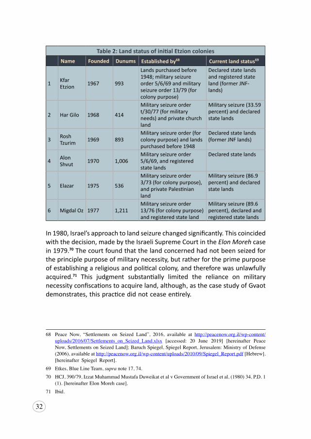
Initially and explicitly, Israel erroneously relied on the exception of “imperative military necessity” under Rule 51 of Customary IHL, as a pretext of land seizure for colony construction. It was a strategy initially upheld by a ruling of the Israeli Supreme Court, which found that the establishment of colonies themselves offered important military and defense functions.65 As a result, from 1968-1979, military orders were the principle method by which Israel acquired land,66 and seized approximately 47,000 dunums of private land in the West Bank for supposed military needs.67 In the Etzion Colonial Bloc, this mechanism was used to establish all of the early colonies; the majority for the overt purpose of implanting a settler-colonial population and not for military necessity (see Table 2).
65 HCJ,AyyubetalvMinisterofDefenseetal,33(2),PD,113(1979),(Isr.);BADILResourceCenterforPalestinianResidencyandRefugeeRights(BADIL), Israeli Land grab and Forced Population Transfer of Palestinians: A Handbook for Vulnerable Individuals and Communities, (Bethlehem,Palestine, 2013), available at http://www.badil.org/phocadownload/Badil_docs/publications/handbook2013eng.pdf [hereinafter BADIL, Land Grab].
66 NirShalev,Under the Guise of Legality: Israel’s declarations of state land in the West Bank, B’tselem,February 2012, 8, available at https://www.btselem.org/download/201203_under_the_guise_of_legality_eng.pdf [hereinafter Shalev, Guise of Legality].
67 BADIL,LandGrab,supranote65,34.
32
68,69
Table 2: Land status of initial Etzion colonies Name Founded Dunums Established by68 Current land status69
1 KfarEtzion 1967 993
Lands purchased before 1948; military seizure order 5/6/69 and military seizure order 13/79 (for colony purpose)
Declared state lands and registered state land (former JNF-lands)
2 Har Gilo 1968 414
Military seizure order t/30/77 (for military needs) and private churchland
Military seizure (33.59 percent) and declaredstate lands
3 RoshTzurim 1969 893
Military seizure order (for colony purpose) and landspurchased before 1948
Declared state lands(former JNF lands)
4 AlonShvut 1970 1,006
Military seizure order 5/6/69, and registeredstate lands
Declared state lands
5 Elazar 1975 536
Military seizure order 3/73 (for colony purpose), and private Palestinianland
Military seizure (86.9 percent) and declaredstate lands
6 Migdal Oz 1977 1,211 Military seizure order 13/76 (for colony purpose)and registered state land
Military seizure (89.6 percent), declared andregistered state lands
In 1980, Israel’s approach to land seizure changed significantly. This coincided with the decision, made by the Israeli Supreme Court in the Elon Moreh case in 1979.70 The court found that the land concerned had not been seized for the principle purpose of military necessity, but rather for the prime purpose of establishing a religious and political colony, and therefore was unlawfully acquired.71 This judgment substantially limited the reliance on military necessity confiscations to acquire land, although, as the case study of Gvaot demonstrates, this practice did not cease entirely.
68 Peace Now, “Settlements on Seized Land”, 2016, available at http://peacenow.org.il/wp-content/uploads/2016/07/Settlements_on_Seized_Land.xlsx [accessed: 20 June 2019] [hereinafter PeaceNow,SettlementsonSeizedLand];BaruchSpiegel,SpiegelReport,Jerusalem:MinistryofDefense(2006),availableathttp://peacenow.org.il/wp-content/uploads/2010/09/Spiegel_Report.pdf[Hebrew].[hereinafter Spiegel Report].
69 Etkes,BlueLineTeam,supranote17,74.70 HCJ,390/79,IzzatMuhammadMustafaDuweikatetalvGovernmentofIsraeletal,(1980)34,P.D.1
(1).[hereinafterElonMorehcase].71 Ibid.
33
Case Study: The Development of Gvaot Colony
In 1982, Israel declared a new military base, known as a Nahal Brigade settlement, in the Etzion Colonial Bloc located on agricultural land of the Palestinian villages of Nahhalin and Al-Jab’a. A nahal in these contexts is a plot of land, seized on the basis of military necessity, which is then used as an impermanent base by military officers for agricultural cultivation purposes and other non-military actions.72 Use for such non-military purposes clearly falls short of the threshold for establishing imperative military necessity, by which such a seizure might be deemed lawful under customary IHL.73 Moreover, military nahals have frequently been deployed by Israel as a pretext for the establishment of colonies and in this case, Gvaot was no exception. Evidence disclosed in the Spiegel Report showed that from the outset, this was the intention with Gvaot, noting that on 28 August 1982, the Israeli cabinet approved the establishment of the Gvaot colony as a “cooperative settlement.”74 This further debunks the claimed intention of military use and necessity.
Gvaot existed for several years under the guise of a military nahal, located on land subsequently re-zoned as “state land” in 1984. Then, in 1997, the Israeli military base was replaced by several caravans housing Israeli-Jewish- yeshiva,75 who are students and youth dedicated to studying the Torah, and their families. These colonizers later established a contract with the World Zionist Organization’s (WZO) settlement division to remain in Gvaot even after the Yeshiva moved to Efrat.76 With such a contract, Gvaot had to either be registered as a new colony or as an expansion of a previous colony, so in 1998, Gvaot was regularized as part of the official borders of the Alon Shvut colony. This is a common practice whereby Israel designates new colonies as neighborhoods of previously existing colonies in order to facilitate the further colonization of vast swaths of land throughout the oPt. Colonizers are
72 ZviSobel,BenjaminBeit-Hallahmi,eds.,JewishnessandJudaisminContemporaryIsrael(NewYork:StateUniversity ofNewYork Press, 1991), available at https://bit.ly/2YidDNV [accessed 20 June2019].
73 ICRC,CustomaryInternationalHumanitarianLaw,Rule51:PublicandPrivatePropertyinOccupiedTerritory, available at https://ihl-databases.icrc.org/customary-ihl/eng/docs/v1_rul_rule51 [accessed20June2019].
74 SpiegelReport,supranote68.75 YeshivaisaHebrewword,meaning areligiousschoolforstudyoftheTorahandTalmud.76 TovahLazaroff,“BarakApprovesNewSettlerHomesinGevaot”,The Jerusalem Post, 10February
2012,availableathttp://www.jpost.com/Diplomacy-and-Politics/Barak-approves-new-settler-homes-in-Gevaot [hereinafter Lazaroff,Gevaot].
34
able to simply obtain approval from the Minister of Defense to build housing units in an already approved colony, thereby avoiding the onerous process of obtaining permits designating a new colony.77 Israel thus acts on the fiction that the new units are part of an already existing colony and not part of establishing a new one.78
While several attempts and plans were made to approve permanent housing in Gvaot, they were not officially approved or implemented until 2012, when the 60 caravans that occupied the land were permitted to establish permanent housing units.79 Ehud Barak, the Israeli Defense Minister at the time, authorized the construction of both the permanent housing as well as educational facilities specified for colonizers with special needs.80 For all practical purposes, including local level management in the Gush Etzion Regional Council, the colony is designated and functions as its own colony separate from Alon Shvut and is promoted for its inclusion of special needs residents and amenities, as well as employment opportunities and facilities for such individuals.81
In 2014, the ICA, on instruction from the political echelons, made the largest designation of “state land” in the area since the 1980s, designating 4,000 dunums of Palestinian land in the surrounding area to the Gvaot colony.82
The intention, as expressed by the Gush Etzion Regional Council, is that this designation of land to Gvaot, “paves the way for the new city of Gvaot” which will provide continuity with the nearby Beitar Illit colony,83 and Israeli colonies on the other side of the Green Line.84 For the time being, expansion occurs in
77 PeaceNow,“NetanyahuEstablished20NewSettlements”,newsrelease,3December2015,availableat http://peacenow.org.il/en/netanyahu-established-20-new-settlements [accessed 20 June 2019] [hereinafter Peace Now, New Settlements].
78 Peace Now, “Gevaot - a New SettlementWest of Bethlehem”, news release, 2 September 2012,available at http://peacenow.org.il/en/gevaot-a-new-settlement-west-of-bethlehem [accessed20 June2019] [hereinafter Peace Now, Gevaot].
79 Lazaroff,Gevaot,supranote76.80 PeaceNow,Gevaot,supranote78.81 “Gevaot“,TheGushEtzionFoundation, 2019, available at https://gush-etzion.org.il/project/gevaot/
[accessed 20 June 2019].82 StuartWiner,“Stateseizes1,000acresinWestBank”,The Times of Israel, 31August2014,available
at https://www.timesofisrael.com/state-seizes-1000-acres-in-west-bank/ [accessed 20 June 2019].83 B’tselem,“Israeldeclaressome380hectaresinWestBankasstateland”,pressrelease,10September
2014, available at https://www.btselem.org/settlements/20140910_declaration_of_state_land_in_bethlehem_area [accessed 20 June 2019].
84 JoanneHill,“Bennett:‘WeWillContinuetoBuildOurLand’”,UnitedwithIsrael,3September2014,availableathttps://unitedwithisrael.org/bennett-we-will-continue-to-build-our-land/[accessed20June2019].
35
smaller increments, with further permits for permanent housing granted to the Gvaot colony on 26 December 2018.85 The Gvaot colony, in its evolution from a military nahal to a neighborhood and in all likelihood a future city, is a prime example of the multiple strategies and authorizations utilized by Israel in order to circumvent both national and international law regarding the establishment of colonies, and to advance their colonial enterprise.
b) State Land Declarations
Israel also justifies its land grab in this area on the basis that it is state land, and therefore Israeli land. Directly after the 1967 occupation, 4,100 dunums of land in the Etzion Colonial Bloc were categorized as registered state land.86 This registered state land overlaps with the JNF-‘purchased’ land, that was predominately a Jordanian military camp during Jordanian rule.87 Via the 1967 Military Order Concerning Government Property (59), Israel immediately claimed all land that had been under Jordianian rule as state land. Contrary to international law, Israel utilizes this land for the sole benefit of its civilian population, rather than to benefit the occupied Palestinian population as required by international law.88
Significantly, a 1950 United Nations survey concluded almost 88 percent of the West Bank was privately owned by Palestinians under the old Ottoman Land Code.89 So to appropriate private Palestinian land, extensive legal amendments and manipulation of existing laws was required, all designed to maintain Israel’s veneer of legality, though done in clear violation of international law. These actions have been written about at length, so what follows is a summary of the most salient points.90 In 1980, Israel had conducted a survey of the West Bank that located insufficient state land to
85 PeaceNow,“2,191SettlementHousingUnitsAdvancedonChristmas”,newsrelease,26December2018, available at http://peacenow.org.il/en/2191-settlement-housing-units-advanced-on-christmas [accessed 20 June 2019].
86 DirectinformationfromARIJ87 Shalev,GuiseofLegality,supranote66,10-11.88 State land Allocation in the West Bank- For Israelis Only, PeaceNow,July2018,availableathttp://
peacenow.org.il/wp-content/uploads/2018/07/Lands-Allocated-to-Palestinians-1.pdf89 See UN GA, Official Records Ad Hoc Committee on the Palestine Question, 2d Sess., app.
V, UN Presentation B (1950) referenced in George Bisharat, “Land, Law, and Legitimacyin Israel and the Occupied Territories”, American University Law Review, 43, (1994): 525,available at https://repository.uchastings.edu/cgi/viewcontent.cgi?referer=https://www.google.com/&httpsredir=1&article=1040&context=faculty_scholarship [accessed 20 June 2019].
90 BADIL,LandGrab,supranote65;Shalev,GuiseofLegality,supra note66.
36
enable the establishment of all planned colonies.91 Israel thus amended its definition of “state land” so that land could come into the ownership of the state subsequent to 1967.92 It also began beneficially manipulating its interpretation of the pre-existing Ottoman Land Code, and departed from previously settled doctrine concerning land ownership in Palestine. Previously, the law had restricted private land (mulk land) to the buildings and built up areas of towns and villages, all agricultural (miri) and open (matrouk) land was held communally and ultimate ownership rested with the state. However, individuals could acquire private ownership rights of agricultural land in perpetuity if they cultivated the land for a period of ten years or more, and paid a fee. That ownership did not necessarily need to be registered in order for the law to recognize it, and indeed much of the land was not registered because the process was complex, and tied to taxation and military service.93 By the end of Jordanian rule, just one third of the land in the West Bank had been registered with the Land Registry.94
In order to maximize its access to state land (though purportedly done to protect the rights of absentee Palestinian owners), Israel ceased virtually all registration of land immediately upon the 1967 occupation and in practice determined that it would only recognize private land if it was registered.95 It revived an old legislative provision, repealed in 1917, which had said that ownership rights would revert back to the state if the miri land ceased to be cultivated for three years or more.96 It also raised the threshold requirement to establish cultivation, particularly as it related to rocky areas.97 These changes violate the requirement under international law that the OP is to respect, unless absolutely prevented, the laws in force in the occupied territory.98 Moreover, the failure to respect Palestinian ownership of miri and matrouk land, whether collectively or individually owned, is in violation of Article 53 of the Fourth Geneva Convention. Notwithstanding, the overriding issue of the entire scheme is predicated on the erroneous position that “state
91 Shalev,GuiseofLegality,supranote66,14.92 OrderConcerningGovernmentProperty(Amendment7)(JudeaandSamaria)(1091)1984.93 NajehS.Tamim, “AHistoricalReviewof theLandTenure andRegistrationSystem inPalestine”,
An-Najah Res. 3,no.9(1995):87-99,availableathttps://journals.najah.edu/media/journals/full_texts/historical-review-land-tenure-and-registration-system-palestine.pdf
94 Shalev,GuiseofLegality,supranote66,32.95 MilitaryOrder291,seeBADIL,LandGrab,supranote65,33.96 BADIL,LandGrab,supranote65,35-37.97 Id.,37.98 HagueRegulations,supranote19,art.43.
37
land” means land owned by and to be used for the benefit of the occupying power, rather than the occupied people.
As such, instead of allowing the Elon Moreh decision to hamper the colonial enterprise, Israel simply changed course. The government issued a decision, “to expand the settlement in Judea, Samaria, the Jordan Valley, the Gaza Strip and the Golan Heights by adding population to the existing communities and by establishing new communities on state-owned land.”99 Adopting the abovementioned legal manipulations, Israel set about declaring great swathes of Palestinian land in the West Bank as state land, replacing the Palestinian population with Israeli-Jewish colonizers to build new colonies, and converting numerous military seizures to state land declarations (See Table 2). Across the West Bank, 750,000 dunums were declared state land in the 1980s.100 Importantly for Israel’s colonization strategy, almost all 655,000 dunums fell within Area C zoning following the categorization of land stipulated in the Oslo Accords.101 In the epicenter area of Etzion alone, more than 22,344 dunums of state land have been declared, primarily in the 1980s, but also including 5,000 dunums declared as recently as 2014.102 This allowed for the establishment of an additional four colonies in the area – Efrat, Neve Daniel, Beitar Illit and Bat Ayin – in the 1980s, and the hastened conversion of militarily seized land to state land in order to sure up the legal foundation of the pre-existing colonies.
Utilizing this strategy, Israel had confiscated almost 42 percent of the West Bank by the mid-1980s, and by 2008 this had increased to 70 percent of West Bank land.103 Israel continues to rely on these declarations to seize more and more Palestinian land. Israel has also applied a series of policies to both inhibit and thwart Palestinian access to and use of land in order to facilitate the claim that the land has been uncultivated and is thus converted to Israeli state land. This process is buttressed by the review and ratification process, undertaken by the Blue Line Team auspiced by the Israeli Civil Administration, whereby boundaries of state land declarations are being surreptitiously and incrementally extended when reviewed by this team.104
99 Government Decision No. 145 of 1 November 1979, 1979;citedinBADIL,LandGrab,supranote65,36. 100Etkes,BlueLineTeam,supranote17.101Ibid.102DirectinformationfromARIJ,andconsistentwiththedatainEtkes,BlueLineTeam,supranote17,74.103BADIL,LandGrab,supra note65,34.104Etkes,BlueLineTeam,supra note17.
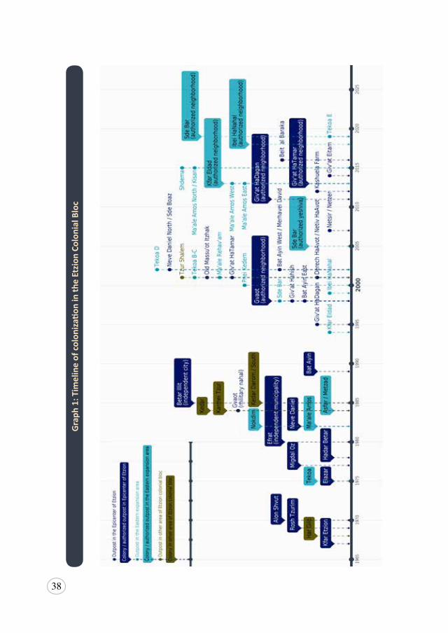
38
Gra
ph 1
: Tim
elin
e of
col
oniza
tion
in th
e Et
zion
Col
onia
l Blo
c
39
c) Establishment of Unauthorized Outposts
After Oslo, there was a significant decrease in the number of state land declarations issued by Israel. Following the signing of the Oslo Accords, Israel unofficially, but publicly decided to cease establishing new colonies. Colonies required formal decisions from the Israeli cabinet and were becoming politically unpopular, particularly internationally. Since Oslo, Israel has relied instead on a process of establishing so-called unauthorized outposts in order to continue its colonial enterprise. This has served two purposes. Initially, it served to conceal the nature of the ongoing expansion in the West Bank, allowing Israel to maintain a semblance of having adhered to international pressure.105 More recently, it has served to enable expansion of the colonial land grab onto private Palestinian land for which registration and ongoing cultivation are provable. In the Etzion Colonial Bloc alone, at least 23 new colonies have been established as unauthorized outposts since 1994 and remain standing at the beginning of 2019 (see Graph 1), while an unknown number have been established and either abandoned or evacuated in that same time period.
Outposts involve Israeli colonizers laying claim to a site by setting up caravans, allegedly without government approval. They are then quickly connected to power and water services, which is indicative of the government oversight involved, and eventually, plans for more permanent housing get approved. Alternatively, an agricultural farm is approved, which slowly begins to house colonizers full-time as caravans are moved to the site, before further plans are approved. The full extent of this strategy was revealed in the Israeli government’s own report, the Sasson Report, released in 2005,106 while the Spiegel Database, leaked in 2009, exposed the extent of Israeli official knowledge about the unlawful construction of colonies in the West Bank.107
Since 2011, Israel has adopted a systematic process of authorizing or so-called legalizing these previously unauthorized outposts. The term used by Israel is legalization of unauthorized outposts, however, this is a misleading
105YossiGurvitz,“ThelieIsraelsoldtheworld-settlement‘outposts’”,+972 Magazine, 3April2015,available at https://972mag.com/the-lie-israel-sold-the-world-settlement-outposts/105185/ [accessed20June2019].
106Israel,CommunicationsDepartment,PrimeMinister’sOffice,Summary of the Opinion Concerning Unauthorized Outposts, TalyaSason,Report(Israel:2005),availableathttps://www.un.org/unispal/document/settlement-outposts-sasson-report-summary-non-un-document-2/ [accessed20 June2019] [hereinafterSassonReport].
107UriBlau,“SecretIsraeliDatabaseRevealsFullExtentofIllegalSettlement”,Haaretz, 1January2009,availableathttps://www.haaretz.com/1.5055488[accessed20June2019].
40
term as all colonies, including outposts, remain unlawful under international law. Throughout this publication, the term authorization is used as a more accurate reflection of Israeli government approval of outposts.
In order to bypass lengthier and more controversial processes of obtaining Israeli Cabinet approval, these outposts are approved as “neighborhoods” of pre-existing colonies.108 For those outposts built on Palestinian land that have already been confiscated as state land, this authorization is a straight-forward process. In some cases, Israel has retroactively declared the outpost site as state land to facilitate this authorization. This manner of approval in connecting often isolated outposts with larger colonies by expanding the parent colony’s jurisdiction, a form of “joining the dots”, allows the gradual opening up of new contiguous areas of colonial control over land.109 So far, five of the outposts in Etzion have been authorized as neighborhoods of nearby colonies (see Table 3).
Case Study: Efrat – The Colony of Many Neighborhoods
Efrat, the second largest colony in the Etzion Colonial Bloc in terms of both population and area, was originally established in 1983 from plans approved in 1979.110 Efrat is a sprawling colony, which has slowly expanded by way of illegal outposts to seven neighborhoods starting in the south, and running almost six kilometers to the north along the eastern side of Route 60, a major Palestinian arterial road. Its location is a major impediment to the realization of the future Palestinian state, and allows for substantial expansion of the colonized area.
Plans for Efrat emerged in 1978, when it was conceived as an urban settlement according to the Master Plan for Judea and Samaria 1979-1983.111 Although
108PeaceNow,NewSettlements,supranote77.109OCHA,“ReportoftheSpecialCommitteetoInvestigateIsraeliPracticesAffectingtheHumanRights
ofthePalestinianPeopleandOtherArabsoftheOccupiedTerritories”,24August2016,A/71/355,4,available at https://www.ohchr.org/Documents/Countries/PS/SG_Report_on_Israeli_A.71.355.pdf
110PeaceNow,“AnewoutpostistoestablishedSouthoftheBethlehem”,newsrelease,30November2011, available at http://peacenow.org.il/en/givateitam?lang=en [accessed 20 June 2019].
111MatityahuDrobles,Master Plan for the Development of Settlement in Judea and Samaria: 1979-1983,WorldZionistOrganization,Department forRuralSettlement, (Jerusalem,October1978), annexedtoUNGeneralAssembly,“Letterdated18October1979 from theChairmanof theCommitteeontheExerciseoftheInalienableRightsofthePalestinianPeopleaddressedtotheSecretaryGeneral”,A/34/605, 22October 1979, available at https://digitallibrary.un.org/record/5195 [accessed20 June2019] [hereinafterDroblesPlan].
41
at the time it was recognized that the conditions were not yet compatible for a large urban colony and plans were initially downgraded to a community settlement,112 the plans for a large, sprawling colony persisted and in 1992 the major expansion plan, 5/410, was approved by Israel. The plan proposed expansion onto three hills north of the original Efrat colony, on privately owned Palestinian land of Al Khader and Artas. Ultimately, despite documents proving ownership back to the British Mandate, the Israeli High Court upheld a controversial state land declaration on the basis that the rocky outcrops were not sufficiently cultivated, and the regular grazing activities did not constitute any recognized form of ongoing use.113
With the signing of the Oslo Accords, colony construction was supposedly on hold but, as has often been the case with the initial establishment of outposts, colonizers defied Israeli public policy in protest of any perceived limitation on their apparent rights, and in this case, the peace agreement with the Palestinians.114 Although the outposts on Givat Hadagan and Givat Hatamar were evacuated several times, plans had already been approved for 500 housing units at Givat Hatamar. To avoid controversy, the Israeli cabinet offered the “compromise” of construction at Givat Hazayit,115 an area closer to the existing Efrat colony.
In 1997, in defiance of an Israeli High Court injunction in the still pending state land challenge, the Israeli government began construction of Givat Hazayit on the hill of Um Talea’, also a rocky patch of private Palestinian land that had belonged to the villages of Al Khader and Artas.116 This construction was followed by illegal outpost expansion once again to Givat Hadagan in the late 1990s and Givat Hatamar in 2001. Although unrecognized, this expansion was facilitated by the Israeli military, that in 2001, launched flares that scorched the land and trees near Givat Hatamar ahead of caravans being
112Ibid.113TheMonitoringIsraeliColonizingActivitiesproject(POICA),“ANewIsraeliColonyintheSouthern
VicinityofBethlehemGivatHazayit(UmTale’Hill)”,ARIJ,17March1997,availableathttp://poica.org/1997/03/a-new-israeli-colony-in-the-southern-vicinity-of-bethlehem-givat-hazayit-um-tale-hill/ [accessed20June2019][hereinafterPOICA,GivatHazayit].
114JewishTelegraphicAgency,“IsraeliForcesEvacuateSettlersAsEfratClaimsNearbyHilltops”,newsrelease, 31 July 1995, available at https://www.jta.org/1995/07/31/archive/israeli-forces-evacuate-settlers-as-efrat-claims-nearby-hilltops;JewishTelegraphicAgency,“NewAnalysis:ControversyoverEfratExpansionRaisesNewQuestionsAboutSelf-Rule”,newsrelease,3January1995,availableathttps://www.jta.org/1995/01/03/archive/news-analysis-controversy-over-efrat-expansion-raises-new-questions-about-self-rule[allaccessed20June2019].
115POICA,GivatHazayit,supranote113.116Ibid.
42
re-established onsite.117 Those outposts have subsequently been authorized as neighborhoods of Efrat, with formal plans approved. The construction of hundreds of housing units are well underway, including construction contracts offered by the Israeli Land Administration for 98 year leases with the option to extend for a further 98 years.118 The pattern was repeated with Givat Eitam, a caravan outpost established several times by colonizers from Efrat, including recently after the death of a colonizer from Efrat.119 Although formal approval has been withheld and delayed several times due to international pressure, with the right political conditions, Israel has recently moved towards the formal development of plans (see below).
In addition to the ‘outpost to neighborhood’ expansion pattern, Efrat’s existing communities often expand to private Palestinian land with full complicity from the Israeli authorities. The Spiegel Report revealed that in the neighborhood of Hate’ena, there are illegal caravans on private land without plan approval, as well as earth dumped and an industrial building built on private Palestinian land. Further, in the neighborhood of Hadekel there is documented Israeli government knowledge of a park and synagogue built on private land, as well as 12 caravans established in the area without plan approval.120
Today, Efrat’s current population has just exceeded 10,000 colonizers, with an additional 7,000 expected within the next two years according to the colony’s website. This is a reference to the long-planned expansion of the colony to Givat Eitam, where estimates of the proposed population vary between 2,500 and 7,000 depending on the Israeli source. The colony website also refers to future plans for an urban population that will top more than 30,000. For the moment, the colony includes 30 synagogues, a veteran center, a youth center, elderly care facility, community center, and a fitness center, and is considered the capital of Gush Etzion.
117POICA, “Resorting to Scorched Earth Policy to Expand Efrat settlement”, ARIJ, 8 June 2001,available at http://poica.org/2001/06/resorting-to-scorched-earth-policy-to-expand-efrat-settlement/ [accessed 20 June 2019].
118DeGarmo,SettlementEnterprise,supranote,51,316-320.119YotamBerger,“SettlersEstablishWestBankOutpost inResponse to Israeli-American’sMurder in
Terror Attack”, Haaretz, 21 September 2018, available at https://www.haaretz.com/israel-news/.premium-settlers-establish-west-bank-outpost-in-response-to-israeli-american-s-murder-in-terror-attack-1.6492598 [accessed 20 June 2019] [hereinafter Berger, Settlers Outpost].
120SpiegelReport,supranote68.
43
d) ‘Survey Land’ Designation and Acquisition of Private Palestinian Land
Most outposts are not built on “state land”. Many are wholly or partially on land that even Israeli law considers to be private Palestinian land121 and historically, Israel seized private Palestinian land on the basis of bogus military necessity.122 As Israel insists on functioning under a veil of legality in all their policies and actions, the policy shift towards acquisition of private Palestinian land has been more incremental. While Israel has consistently issued demolition orders for many of these colony structures built on private Palestinian land, in most cases it has refrained from implementation. It has also preferred to identify them as “survey lands” over which status remains to be determined rather than authorizing a number of these outposts. This prolongs the existence of these colonies on private Palestinian land. One such example is the outpost of Derech HaAvot (or Netiv HaAvot), which had been classified “survey land” despite extensive documentation showing private Palestinian ownership as well as clear evidence of land cultivation.123 Though there have been some rare successes in the Israeli High Court that have led to Palestinian landowners obtaining orders to evict colonizers from their land, as was the case for Derech HaAvot, the Court’s bias towards Israeli colonial activities in the oPt remains prevalent. These nominal court successes have led to an upsurge in pressure from within the Israeli government and colonizer interest groups, demanding that the Israeli courts ‘legalize’ all unauthorized outposts.
In 2012, the Netanyahu administration released the controversial Report on the Legal Status of Building in Judea and Samaria (the Levy Report). In rejecting long established principles of international law, the report called for the legalization of all outposts and a simplification of the process for establishing and expanding colonies in the West Bank, on the basis that the West Bank is not under occupation and Israel is entitled to all of the land of Mandatory Palestine, as per the Balfour Declaration. Although never formally adopted
121Chaim Levinson, “2,026 Settlement Homes Built on Private Palestinian Land, Right-wing StudyFinds”, Haaretz, 3 May 2015, available at https://www.haaretz.com/study-2-026-homes-built-on-private-palestinian-land-1.5357723 [accessed 20 June 2019].
122ThisfollowedthefindingsoftheElon Moreh case.ThecommentappearsinthejudgmentofJusticeBechor,seeTheElonMorehcase,supranote70.
123PeaceNow,“NativHa’AvotFile:HonoringtheSupremeCourtRuling:SayingNotoTheftofPrivateLand”, N.d., available at http://peacenow.org.il/wp-content/uploads/2017/12/NativHaavotFileENG.pdf[hereinafterPeaceNow,NativHa’AvotFile].
44
as governmental policy, it has nonetheless guided Israeli decision-making.124 Consistent with this report, in 2017, Israel passed the Settlement Regularization Law.125 On the Israeli government’s own admission, “the overriding goal of the law is to regulate the status of those [Israeli] settlements, neighborhoods or houses whose regulation has been prevented until now, primarily due to the fact that the right of ownership of those lands is not in the hands of the state or of those who hold it.”126 Essentially stating that despite Palestinian existence and land ownership, Israel will continue to pass legislation supporting and furthering their annexation and colonization of private Palestinian land.
In the Etzion Colonial Bloc, this new law paves the way for retroactive authorization of construction in at least 17 colonies, including eight outposts, 556 housing units and 20 other structures.127 It potentially involves the permanent appropriation of an additional 708 dunums of private Palestinian land, not including thousands of dunums of private land under the jurisdiction of colonies in the bloc, though not yet subject to construction.
124ChaimLevinson,“StatetoHinderRemovalofSettlersfromPrivateLand”,Haaretz,27May2014,available at https://www.haaretz.com/.premium-govt-carrying-out-pro-settler-report-1.5249771 [accessed 20 June 2019].
125LawfortheRegularizationofSettlementinJudeaandSamaria,5777,2017,SH2604,(Isr.).Englishtranslation available at https://www.adalah.org/uploads/uploads/Settlement_Regularization_Law_English_FINAL_05032017.pdf [hereinafter Settlement Regularization Law]; Note: the substantiveprovisionsofthisremainsuspendedbyinjunctionoftheIsraeliSupremeCourtpendingtheoutcomeofaconstitutionalchallengeinthematterofTheSilwadMunicipality,etal.v.TheKnesset,etal.(petitionpending),HCJ1308/17.
126 See para 93 of theGovernmentResponse filed inTheSilwadMunicipality, et al. v.TheKnesset,et al. (petition pending), HCJ 1308/17, available at https://www.adalah.org/uploads/uploads/Settlement_regulation_law_state_reply_23082017.pdf(hebrew),citedinAdalah,The Responses of the Government of Israel and the Attorney General in the Settlements Regularization Law Case,January2018, available at https://www.adalah.org/uploads/uploads/Adalah_Responses_of_the_Government_and_AG_to_Settlements_Law_Final_English_17.1.2018.pdf [hereinafter Government Responses toSettlement Regularization Law].
127 The Grand Land Robbery: Another Step toward Annexation, PeaceNow,November2016,availableathttp://peacenow.org.il/wp-content/uploads/2016/11/regulation-law-report.pdf
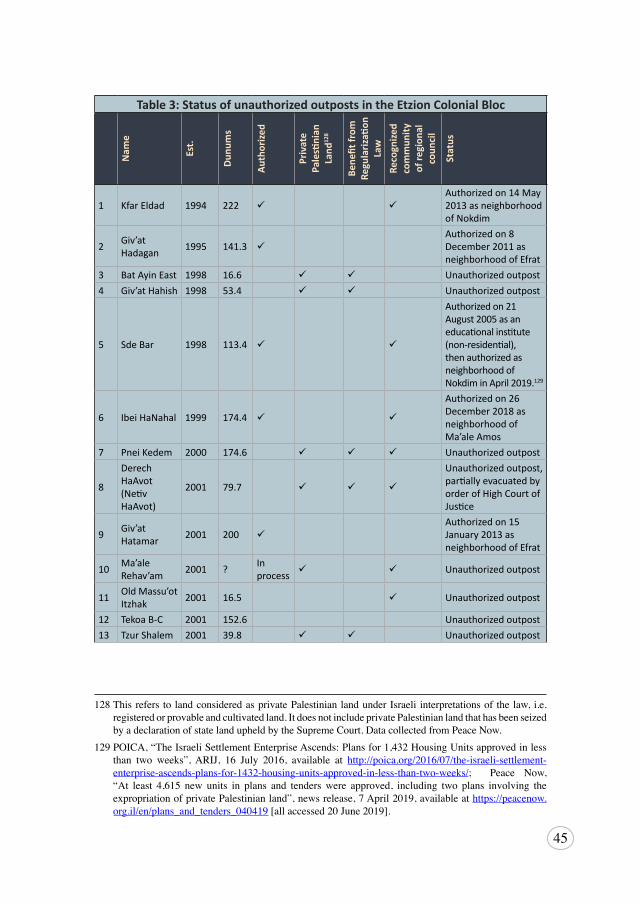
45
128 , 129,
Table 3: Status of unauthorized outposts in the Etzion Colonial Bloc
Nam
e
Est.
Dunu
ms
Auth
orize
d
Priv
ate
Pale
stini
an
Land
128
Bene
fit fr
om
Regu
lariz
ation
La
wRe
cogn
ized
com
mun
ity
of re
gion
al
coun
cil
Stat
us
1 Kfar Eldad 1994 222 ü üAuthorized on 14 May 2013 as neighborhood of Nokdim
2 Giv’at Hadagan 1995 141.3 ü
Authorized on 8 December 2011 as neighborhood of Efrat
3 Bat Ayin East 1998 16.6 ü ü Unauthorized outpost4 Giv’at Hahish 1998 53.4 ü ü Unauthorized outpost
5 Sde Bar 1998 113.4 ü ü
Authorized on 21 August 2005 as an educational institute (non-residential), then authorized as neighborhood of Nokdim in April 2019.129
6 Ibei HaNahal 1999 174.4 ü ü
Authorized on 26 December 2018 as neighborhood of Ma’ale Amos
7 Pnei Kedem 2000 174.6 ü ü ü Unauthorized outpost
8
Derech HaAvot (Netiv HaAvot)
2001 79.7 ü ü ü
Unauthorized outpost, partially evacuated by order of High Court of Justice
9 Giv’at Hatamar 2001 200 ü
Authorized on 15 January 2013 as neighborhood of Efrat
10 Ma’ale Rehav’am 2001 ? In
process ü ü Unauthorized outpost
11 Old Massu’ot Itzhak 2001 16.5 ü Unauthorized outpost
12 Tekoa B-C 2001 152.6 Unauthorized outpost13 Tzur Shalem 2001 39.8 ü ü Unauthorized outpost
128 Thisrefers to landconsideredasprivatePalestinianlandunderIsraeli interpretationsof thelaw, i.e.registeredorprovableandcultivatedland.ItdoesnotincludeprivatePalestinianlandthathasbeenseizedbyadeclarationofstatelandupheldbytheSupremeCourt.DatacollectedfromPeaceNow.
129 POICA,“TheIsraeliSettlementEnterpriseAscends:Plansfor1,432HousingUnitsapprovedinlessthan two weeks”,ARIJ, 16 July 2016, available at http://poica.org/2016/07/the-israeli-settlement-enterprise-ascends-plans-for-1432-housing-units-approved-in-less-than-two-weeks/; Peace Now,“At least 4,615 new units in plans and tenderswere approved, including two plans involving theexpropriationofprivatePalestinianland”,newsrelease,7April2019,availableathttps://peacenow.org.il/en/plans_and_tenders_040419[allaccessed20June2019].
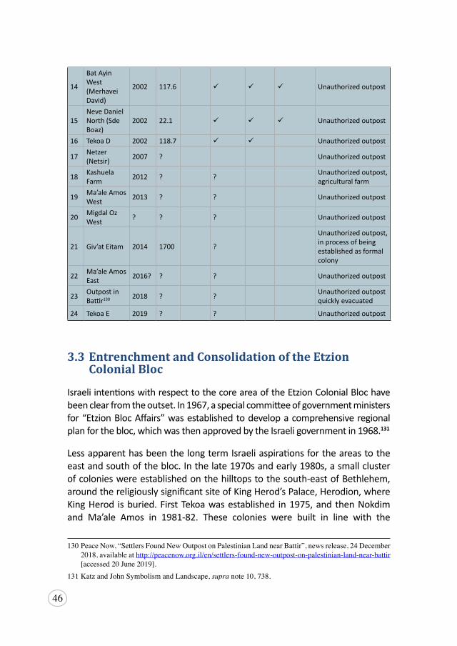
46
14
Bat Ayin West (Merhavei David)
2002 117.6 ü ü ü Unauthorized outpost
15Neve Daniel North (Sde Boaz)
2002 22.1 ü ü ü Unauthorized outpost
16 Tekoa D 2002 118.7 ü ü Unauthorized outpost
17 Netzer (Netsir) 2007 ? Unauthorized outpost
18 Kashuela Farm 2012 ? ? Unauthorized outpost,
agricultural farm
19 Ma’ale Amos West 2013 ? ? Unauthorized outpost
20 Migdal Oz West ? ? ? Unauthorized outpost
21 Giv’at Eitam 2014 1700 ?
Unauthorized outpost, in process of being established as formal colony
22 Ma’ale Amos East 2016? ? ? Unauthorized outpost
23 Outpost in Battir130 2018 ? ? Unauthorized outpost
quickly evacuated
24 Tekoa E 2019 ? ? Unauthorized outpost
130
3.3 Entrenchment and Consolidation of the Etzion Colonial Bloc
Israeli intentions with respect to the core area of the Etzion Colonial Bloc have been clear from the outset. In 1967, a special committee of government ministers for “Etzion Bloc Affairs” was established to develop a comprehensive regional plan for the bloc, which was then approved by the Israeli government in 1968.131
Less apparent has been the long term Israeli aspirations for the areas to the east and south of the bloc. In the late 1970s and early 1980s, a small cluster of colonies were established on the hilltops to the south-east of Bethlehem, around the religiously significant site of King Herod’s Palace, Herodion, where King Herod is buried. First Tekoa was established in 1975, and then Nokdim and Ma’ale Amos in 1981-82. These colonies were built in line with the
130 PeaceNow,“SettlersFoundNewOutpostonPalestinianLandnearBattir”,newsrelease,24December2018,availableathttp://peacenow.org.il/en/settlers-found-new-outpost-on-palestinian-land-near-battir [accessed20June2019].
131KatzandJohnSymbolismandLandscape,supranote10,738.
47
Drobles Plan, the Master Plan for the Development of Settlement in Judea and Samaria: 1979-1983, published by the WZO. The Drobles Plan set out explicitly to establish colonial continuity throughout the West Bank, with Israeli-Jewish colonies planned in and around Palestinian communities, and the plan was to be enacted irrespective of the political situation and any peace agreements.132
Slow development and growth in these colonies through the 1980s and 90s, has given way to extensive growth and consolidation, so much so that by early 2019, there were 15 colonies in this area, including an outpost established at the beginning of 2019, Tekoa E,133 and an industrial park under construction on recently declared state land at Kisan, near Ma’ale Amos.134 Several of these colonies – Kfar Eldad, Sde Bar and Ibei HaNahal – are outposts that have been authorized by Israel as neighborhoods of nearby colonies, while more than one million NIS had been invested in the development of Herodion as a tourist destination. In order to achieve this consolidation and expansion, Israel has deployed a number of additional mechanisms, including creating bureaucratic structures developing road infrastructure, increasing the settler-colonial population, economic domination, and controlling of natural resources.
Case Study: The Early Establishment of Tekoa and Ma’ale Amos
Tekoa and Ma’ale Amos were colonies that began as military nahals or state land declared by Israeli military order, similar to Gvaot, before quickly evolving into civilian colonies. They were established together as outlined in the Drobles Plan, with the explicit intent to provide continuity from the Dead Sea, to the Etzion bloc and through to the Adulam District on the other side of the Green Line, despite the existence of Palestinian villages and their cultivation and use of the land.135
Established in 1975, Tekoa became an urban colony two years later, in 1977. Virtually from its inception, Tekoa was intended to become a large urban settlement
132DroblesPlan,supranote111,4.133PeaceNow,“NewoutpostestablishedsouthofBethlehem:TekoaE”,newsrelease,7February2019,
available at http://peacenow.org.il/en/new-outpost-established-south-of-bethlehem-tekoa-e [accessed20June2019][hereinafterPeaceNow,TekoaE].
134JadIsaacetal.,The Segregation Wall impacts on Palestinian Environment, ARIJ,December2015,17,available at https://www.arij.org/files/arijadmin/Inflating_Israeli_Settlements_Enterprise_In_Pose_of_the_Peace_Process__opt.pdf[hereinafterIsaacetal.,SegregationWall].
135DroblesPlan,supra note111,8-9.
48
“because of its relative distance from the other Etzion Bloc settlements […], which would have another 200 families within one year and 800 families after five years.”136 Even today, at its present size, Tekoa occupies only 1070 dunums of the intended 1970 dunums intended for the colony, all of which consist of land originally belonging to the Palestinian village of Tuqu’ (pronounced Tekoa).137 By 2017, it had become one of the largest colonies, with 3750 colonizers,138 aided in its expansion by three illegal outposts Tekoa B-C (previously referred to as Tekoa C), Tekoa D, and Tekoa E.139 As with most outposts, though illegal under Israeli law, they have been established with the tacit approval from the Israeli government.140 The leaked Spiegel Report revealed outposts Tekoa B-C and Tekoa D were both established on a mixture of state land, survey land that was subsequently declared state land, and private Palestinian land.141 According to an ARIJ report published in 2015, two of these three outposts have been zoned and approved by Israel, while the remaining Tekoa D outpost, has been given unofficial approval and bureaucratic autonomy as it was established by the families of two colonizers killed in the area.142 Despite the technical illegality of these outposts, substantial amounts of the Tekoa annual budget have been invested in ensuring connectivity between the parent colony and the outposts, including the construction of a paved road.143
Similarly, Ma’ale Amos, also referred to as Nahal Amos, began as state land declared by military necessity, which was later approved for establishing the colony by resolutions 1038 and 356 in 1980 and 1981 respectively.144 The land was simultaneously directed towards the World Zionist Organization (WZO) for implementing the colonization process145 and was later colonized and renamed by a group of yeshiva students due to its alleged religious significance and connection to the prophet Amos.146 Yet, it too, from its inception, had
136Id.,8.137ARIJ,The Settlement of Tekoa, 2015, 11, available at http://poica.org/upload/Image/lrc_aug_2015/
report.pdf [hereinafterARIJ, Tekoa].138SassonReport,supra note106.139ARIJ,Tekoa,supranote137,10.140SassonReport,supra note106.141SpiegelReport,supranote68.142ARIJ,Tekoa,supranote137,10.143Id.,11.144POICA,“IsraelisettlersconstructnewbypassroadonlandsofKisanvillage”,ARIJ,8March2016,
available at http://poica.org/2016/03/israeli-settlers-construct-a-new-bypass-road-on-lands-of-kisan-village/[accessed20June2019][hereinafterPOICA,BypassRoad].
145Ibid.146“Ma’aleAmos”, TheGush Etzion Foundation, 2019, available at https://gush-etzion.org.il/project/
maale-amos-2/
49
been conceived by the WZO as a large civilian colony, as the Drobles Plan and Spiegel Report attest.147 The intention was that, along with other colonies planned in the surrounding area, it “could form a territorial continuity with the settlements planned for the Dead Sea shoreline…[and] the Amos Region settlements be linked with Tekoah and the Etzion Bloc settlements by means of a Judean transverse road to be paved from east to west…”148 As with Tekoa, this reality has been incrementally achieved through an additional three outposts, including one recently authorized, as well as an industrial site, built on the lands of the Palestinian village of Kisan.149
Today, these colonies are thriving. Tekoa is known in Israel for its diverse and mixed population both in terms of nationality and degree of religious observance, and as a colony founded primarily by Russian immigrants from the Soviet Union. In contrast, Ma’ale Amos is one of eight ultra-orthodox colonies in the oPt. Despite their demographic variety, a number of strategies have been deployed to build a sustainable lifestyle to overcome the relative isolation from other Israeli colonies. The Amana Settlement Movement, which began in 1978 with the goal of establishing and strengthening colonies throughout ‘Judea and Samaria’, has facilitated the colonization of both Tekoa and Ma’ale Amos. Other groups such as the Israeli building company responsible for much of the colony housing developments, Gush Herodian, created plans for Tekoa’s housing units. Other attractions such as a Tekoa Country Club and swimming pool have been opened and are accessible to all colonizers of the Etzion Colonial Bloc. Three of the founders of Gush Herodion currently live in Tekoa, a practice common among Israeli elites and businessmen involved in the colony movement.150 Another strategy has been incentivising investment. In Tekoa, for example, home buyers are given special mortgages that contain a clause for forgiveness grants valued at $14,000, whereby after 15 years residing in Tekoa, the amount will be written off as “forgiven.” Meanwhile, roads were built to improve the commute time to Jerusalem from 40 plus minutes to under 15 minutes, as well as community level initiatives to build engagement and communication between the colonizers of both colonies.151
147SpiegelReport,supranote68;DroblesPlan,supra note111,8.148DroblesPlan,supra note111,9.149POICA,BypassRoad,supra note144.150ARIJ,Tekoa,supranote137.151SuzanneWeinberg, “Bridging the gap between two communities: theMa’alehAmos-Tekoa kiruv
Kollel”, Toldot, 2 May 2005, available at https://toldot.ru/en/engarticles/eng-articles_6402.html [accessed 20 June 2019].
50
Both Tekoa and Ma’ale Amos are manifestations of colonies long since planned by Israel as urban and residential colonies. Both were originally established as having military necessity or purpose, in order to circumvent cumbersome and often time-consuming procedures in order to colonize Palestinian land. This process is clearly in accordance with the 40-year-old Master Plan’s settlement strategy to colonize in a way that “will enable us [Israel] to bring about the dispersion of the [Israeli] population from the densely populated urban strip of the coastal plain eastward to the presently empty areas of Judea and Samaria…sooner is better.”152
a) Establishment of Bureaucratic Sstructures - Gush Etzion Regional Council
In 1980, Israel established the Gush Etzion Regional Council pursuant to Military Order 783. This action was triggered by the signing of the Camp David Accords in 1978, which provided for the self-governance of all inhabitants in the oPt. This military order was ostensibly passed in order to avoid the situation of colonizers and colonies coming under Palestinian control.153 In fact, these regional councils unlawfully extend Israeli sovereignty into the occupied territory by establishing a legal structure that allowed these councils to be subject to Israeli public administrative law, rather than military law to which Palestinians are subjected.
These Israeli regional councils have also served to deny self-determination to Palestinian communities throughout the West Bank. They have been granted jurisdiction over large areas of Palestinian land, often where the Palestinian population grossly outnumber the colonizer population, and have been conferred with authority to plan and construct colonies, roads, and infrastructure and to control land use in general, all without going through the same planning procedures required of Palestinians.154 This easing of planning requirements on Israeli colonizers occurred alongside a commensurate tightening of Israeli control over Palestinian development and planning, which saw Palestinians stripped of any input and burdened
152DroblesPlan,supra note111,5.153RajaShehadeh,From Occupation to Interim Accords: Israel and the Palestinian Territories, 1997,
available at https://books.google.ps/books?id=k8HKbZQarRIC&dq=military+order+establish+etzion+regional+council&source=gbs_navlinks_s [accessed 20 June 2019].
154BADIL,LandGrab, supra note 65, 17;RamiS.Abdulhadi, “LandUsePlanning in theOccupiedPalestinianTerritories”,Journal of Palestine Studies 19,no.4(1989):46,availableathttps://www.palestine-studies.org/ar/jps/fulltext/39481[accessed20June2019][hereinafterAbdulhadi,LandUse].
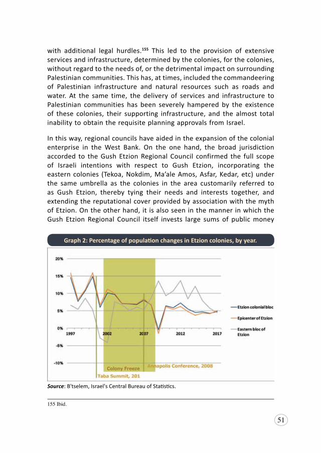
51
with additional legal hurdles.155 This led to the provision of extensive services and infrastructure, determined by the colonies, for the colonies, without regard to the needs of, or the detrimental impact on surrounding Palestinian communities. This has, at times, included the commandeering of Palestinian infrastructure and natural resources such as roads and water. At the same time, the delivery of services and infrastructure to Palestinian communities has been severely hampered by the existence of these colonies, their supporting infrastructure, and the almost total inability to obtain the requisite planning approvals from Israel.
In this way, regional councils have aided in the expansion of the colonial enterprise in the West Bank. On the one hand, the broad jurisdiction accorded to the Gush Etzion Regional Council confirmed the full scope of Israeli intentions with respect to Gush Etzion, incorporating the eastern colonies (Tekoa, Nokdim, Ma’ale Amos, Asfar, Kedar, etc) under the same umbrella as the colonies in the area customarily referred to as Gush Etzion, thereby tying their needs and interests together, and extending the reputational cover provided by association with the myth of Etzion. On the other hand, it is also seen in the manner in which the Gush Etzion Regional Council itself invests large sums of public money
155Ibid.
Graph 2: Percentage of population changes in Etzion colonies, by year.
Source: B'tselem, Israel's Central Bureau of Statistics.
52
into unauthorized outposts and illegal construction, with total disregard as to international law and, in some cases, Israeli law.156
b) Increasing the Colonizer Population
Through the 1980s and 90s, these eastern colonies had remained under-developed, with just the four colonies built by the mid-1990s. Moreover, in the various peace negotiations held from 1995 to 2008 between the Israelis and the Palestinians, this area had never been the subject of land swap proposals, including even the most ambitious land swap deals proposed by Israel.157 It has always been understood that these colonies would be evacuated in any two-state solution peace deal.
However, since the last round of formal discussions in Annapolis in November 2007, the investment in these colonies has been particularly notable, especially the almost 150 percent increase in the population of this group of colonies to approximately 7,060 colonizers at the end of 2017. This is a substantially higher growth rate than the 62 percent growth seen in the Etzion Colonial Bloc overall during the same period (see Graph 2).158 It also coincides with the opening of Route 398 (also called the Lieberman Road), in 2008, a major road investment which now connects these colonies to Jerusalem within 10-15 minutes.159 Today, Tekoa is the third largest colony in the bloc, after Beitar Illit and Efrat, and in the top 25 largest colonies in the West Bank.160 In other words, Israel has invested considerably in this area’s expansion in order to consolidate Israeli claims to this land at the expense of past and present Palestinian presence. These actions indicate a clear commitment to the original Zionist intentions with respect to the West Bank, as outlined in the Drobles Plan.
In the short term, this has involved investment in the area to increase the colonizer population, improve their access to services and industry, and deliver greater connectivity between each of these eastern colonies of
156PeaceNow,“TheGushEtzionRegionalCouncilfinancedhundredsofthousandsofshekelsinillegalactivity in 2017”, press release, August 2018, available at http://peacenow.org.il/en/gush-etzion-regional-council-financed-hundreds-thousands-shekels-illegal-activity-2017[accessed20June2019].
157EconomicCooperationFoundation,“TerritorialExchange(LandSwap)OverviewMap”,availableathttps://ecf.org.il/maps/55d97f4c3e00004101f79c27?options=ZPBLSF [accessed20 June2019].
158B’tselem, “Settlements Population Spreadsheet”, available at https://www.btselem.org/download/settlement_population.xls [hereinafter B’tselem, Settlements Population] [accessed 20 June 2019].
159BarbaraOpall-Rome,“’LiebermanRoad’TurnsSettlements IntoSuburbs”,Defense News, 23May2016,availableathttps://www.defensenews.com/home/2016/05/23/lieberman-road-turns-settlements-into-suburbs/[hereinafterOpall-Rome,LiebermanRoad][accessed20June2019].
160B’tselem,SettlementsPopulation,supra note158.
53
the Etzion Colonial Bloc and to Jerusalem. The authorization of outposts, particularly, allows for a greater security of tenure and the construction of more appealing and comfortable housing units as opposed to the caravans and moveable homes that typify outposts, which entice more colonizers to these colonies. Similarly, the construction of Route 398 and the Ma’ale Amos industrial area enable further expansion and a more urban lifestyle. This growth is also reflected in plans and tenders for construction of new housing units, in particular 6,000 additional units in Ma’ale Amos,161 and in the land zoning around these colonies, with several areas of existing “state land” declarations and other areas at risk of being subject to additional declarations due to non-cultivation and their Area C classification.
c) Development of Transportation Infrastructure
Roads function as a tool to facilitate Israeli colonial expansion and annexation – as particularly evident in the case of Etzion Colonial Bloc. From the west and east of the bloc, there are roads that have been constructed to connect new colonies, with previously annexed colonies and to link the colonies to “Greater Jerusalem”. Transport plans were drawn up in the late 60s, and revised in the 1980s, to create continuity of the road and transport network across the Green Line.162 The road network was made convenient for colonizer use, rather than congruent with the needs of the Palestinian population. As a result, since 1967, Israel has successfully reconfigured the road system of the West Bank, which did run primarily north to south, into a system that runs east-west allowing ease of movement for the colonizers across the Green Line.163
The way in which this mechanism works to consolidate colonization is clear throughout the Etzion Colonial Bloc. One example is Route 60, which cuts through the Etzion bloc as it passes from Jerusalem towards Hebron in the south. Besides connecting Jerusalem and Hebron, it connects all the western Etzion colonies to both cities. Much of the road runs along what used to be the old Jerusalem-Hebron (Al Quds-Al Khalil) Road, which ran through Bethlehem proper. Its southern part remains the major arterial road used by Palestinians to connect to Hebron. However, as it runs north it becomes 161 Lieberman Road- Case Study, PeaceNow, 2015, 1, available at http://peacenow.org.il/wp-content/
uploads/2016/01/leiberman-road-report.pdf [hereinafter Peace Now, Lieberman Road].162TheJerusalemMasterPlanBureau,The Master Plan 1968: Interim Report,1969;MeronBenvenisti,
The West Bank Data Project, AmericanEnterpriseInstituteforPublicPolicy,WashingtonD.C.(1984).[hereinafterBenvenisti,WestBank].
163Lynk,ReportonHumanRights,supranote36,12-13.
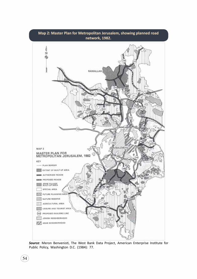
54
Map 2: Master Plan for Metropolitan Jerusalem, showing planned road network, 1982.
Source: Meron Benvenisti, The West Bank Data Project, American Enterprise Institute for Public Policy, Washington D.C. (1984): 77.
55
inaccessible to Palestinians without a permit, and Palestinians are forced to divert off the road into Bethlehem. Where once Palestinians had easy access between Jerusalem, Bethlehem and Hebron, there is no longer one continuous road connecting any of these cities. Eventually, construction of the Wall will prevent Palestinians from accessing this road at all, and they will be diverted onto smaller roads running to the east of Efrat.164
Additionally, there are now plans underway to widen Route 60 between Beit Jala and Al Arroub refugee camp, just south of the Etzion junction, from two to four lanes, as well as a public transport lane.165 Israel has allocated $50 million to the expansion project, and will take thousands of dunums of Palestinian land to construct.166 This expansion will then connect to the Al Arroub bypass that will be constructed on land belonging largely to the Palestinian towns of Beit Ummar and Halhul, with 401 dunums of land confiscated in April 2019, and a further 1273 dunums due to be confiscated to complete the illegal project.167 It is expected this road will be a segregated road, with lanes for colonizers-only, and will isolate Palestinian villages, including Al Arroub refugee camp, and close the northern entrance to Halhul.168 This construction is a critical precursor to increasing the population of colonies in the Etzion bloc as well as those further south into Hebron. By improving traffic flow and connectivity in the area, this infrastructure makes the area a more attractive residential option to potential colonizers.
The eastern side of the Etzion Colonial Bloc also has several colonizer roads, particularly Routes 398 and 356, that serve to connect these colonies to others in the heart of the bloc and link them to Jerusalem through Har Homa colony. Prior to the construction of Route 398 specifically, these colonies to the east had been relatively isolated; Jerusalem required a 40 minute drive through Palestinian villages. Now Route 398 connects Tekoa and Nokdim colonies with 164OCHA, West Bank: Movement and Access, June 2010, 27, available at https://www.ochaopt.org/
content/west-bank-movement-and-access-update-june-2010 [accessed 20 June 2019].165OferPetersburg,“WestBankroadstoreceiveNIS5billionupgrade”,Ynet News,2July2017,available
athttps://www.ynetnews.com/articles/0,7340,L-4918936,00.html[accessed20June2019].166AnanShahadeh,SalahTmeizi,“Palestiniansfearwideninghighway60insouthofWestBankpart
of settlement expansion plan”, WAFA, 24 October 2018, available at http://english.wafa.ps/page.aspx?id=BFBV2fa106202310258aBFBV2f [accessed 20 June 2019].
167InternationalMiddle EastMediaCenter (IMEMC), “PartOfOneOfBiggestColonialist Projects;Israel Issues Orders Illegally Confiscating 401 Dunums Of Lands Near Hebron”, 10April 2019,available at https://imemc.org/article/part-of-one-of-biggest-colonialist-projects-israel-issues-orders-illegally-confiscating-401-dunumdunums-of-lands-near-hebron/ [accessed 20 June 2019].
168Ibid; Peace Now, “800 Million Shekel Plan for Bypass Roads in the West Bank Approved byNetanyahu”,newsrelease,26October2017,availableathttp://peacenow.org.il/en/800-million-shekel-plan-bypass-roads-west-bank-approved-netanyahu [accessed 20 June 2019].
56
Har Homa colony in under 15 minutes and is one of the largest annexation roads in the Etzion Colonial Bloc. It was built with the explicit aim of creating a more direct route for around 2,000 colonizers living in Tekoa, Nokdim, Ma’ale Amos, and Asfar settlements.169 Sometimes called the Za’atara Road or Lieberman Road, construction of the road began in 2007 and cut through 19,000 dunums of Palestinian land in the Bethlehem governorate.170 From Tekoa, Route 398 connects to 356, which continues south, connecting the colonies of Asfar and Ma’ale Amos, before rejoining Route 60.171
There are also long-term plans to construct a road between Etzion and the Dead Sea, estimated to cost 35 million shekels. The planned route would connect Tekoa, Nokdim and Herodium National Park with the epicenter of the Etzion Colonial Bloc and continue beyond the Green Line into the Beit Shemesh area.172 The current status of the plan is unknown, but is clearly designed to improve connectivity between Israeli colonies and to assert Israeli claims to the land.
These roads have made these colonies more accessible and integrated into the rest of the colonial enterprise, on both sides of the Green Line, thereby increasing their appeal for potential colonizers. The construction of Route 398 has increased the population of the eastern colonies by almost 150 percent since their opening, as well as a 150 percent increase in the number of housing units in the first six years of the road’s opening.173 These roads also make the lives of Palestinians residing in the nearby areas more dangerous as the security apparatus, particularly at checkpoints that guard these roads exposes Palestinians into more frequent daily contact with the Israeli military and colonizers. This in turn increases the risk of fines and other penalties which deter Palestinian use of the roads,174 and also creates flashpoints
169AmericansforPeaceNow(APN),“GushEtzion”,Settlements in Focus1,no.14(2015),availableathttp://peacenow.org.il/eng/content/gush-etzion [accessed20 June2019].
170Opall-Rome,LiebermanRoad,supra note159.171 BenWhite,“BeitSahour:amicrocosmofIsraelicolonization”,The Electronic Intifada,19April2010,
available at https://electronicintifada.net/content/beit-sahour-microcosm-israeli-colonization/8790 [accessed20June2019].
172TzviBen-Gedalyahu,“’DreamRoad’fromGushEtzion toDeadSeaMayExplodePeaceTalks”,The Jewish Press, 17September2013, availableathttps://www.jewishpress.com/news/dream-road-from-gush-etzion-to-dead-sea-may-explode-peace-talks/2013/09/17/;AmichaiAtali,“ThecoalitionispromotinganewroadfromGushEtzion”,nrg News,17September2013,availableathttps://www.makorrishon.co.il/nrg/online/1/ART2/507/588.html [both accessed 20 June 2019].
173PeaceNow,LiebermanRoad,supranote161.174B’tselem,Ground to a Halt: Denial of Palestinians’ Freedom of Movement in the West Bank, August
2007, 23, available at https://www.btselem.org/download/200708_ground_to_a_halt_eng.pdf
57
of violence. This has the ultimate effect of these roads then becoming yet another tool deployed by Israel to segregate and isolate the Palestinian communities from each other, as Palestinians are deterred from using them and/or localized travel routes are severed (as will be explored in Chapter 4: Forcible Population Transfer).
d) Israeli Economic Domination and Exploitation of Natural Resources
The Etzion Colonial Bloc already prevents Bethlehem’s natural growth: to the north, with the Har Homa, Gilo and Har Gilo colonies in Jerusalem; to the north east, with Keidar; and to the west, and the south-east, with the rest of the Etzion colonies. The construction of the newly announced, Giv’at Eitam colony will continue the encirclement and suffocation of Palestinians and eventually will cut Bethlehem off from the rest of Palestine, including the major hubs of both Jerusalem and Hebron. This is already having an impact on the economy of Bethlehem, which will only continue to worsen. At 21 percent unemployment in 2018, Bethlehem governorate experiences the equal highest rate of unemployment in the West Bank.175
Meanwhile, Israel and the colonizers themselves have invested considerably in the establishment of a lifestyle in the Etzion Colonial Bloc. In addition to more than 100 schools throughout the bloc,176 the region also hosts one of three tertiary institutions based in colonies in the West Bank (excluding east Jerusalem).177 Herzog Academic College is a teacher training college established in 1973 and based in Alon Shvut and Migdal Oz colonies, which offers both Bachelors and Masters degrees across 15 different teaching departments.178 Moreover, this institution is now directly subject to Israeli civil law as a result of a new law passed in February 2018,179 which itself
175PCBS,“PCBS:OnTheEveOccasionOfMay1st-InternationalLabourDay”,30April2019,availableathttps://www.pcbs.gov.ps/post.aspx?lang=en&ItemID=3453[accessed20June2019].
176“Education”, Beitar Illit Municipality, 2017, available at https://www.betar-illit.muni.il/education; “Education”, Gush Etziyon Region Council, n.d., available at https://www.baitisraeli.co.il/_klita/en/35/ [both accessed 20 June 2019].
177TheothertwoareArielUniversity,oneofeightIsraeliuniversities,andOrotIsraelCollege,whichhasacampusinElkana.
178“HerzogAcademicCollege”,n.d.,availableathttps://www.herzog.ac.il/en/english/[accessed20June2019].
179MadeehaAraj,“Op.IsraelApplyingAcademiclawsinSettlementsaPolicyofCreepingAnnexation”,Palestine News Network (PNN), 20February2018,availableathttp://english.pnn.ps/2018/02/20/op-israel-applying-academic-laws-in-settlements-a-policy-of-creeping-annexation/ [accessed 20 June2019].
58
represents de facto annexation through the extension of Israeli sovereignty into the West Bank.
Tourism has been another significant investment in the region, with the Gush Etzion tourism page offering more than 40 activities in the region, including hiking, horseback riding, quad-bike tours, wineries, museums, a zoo, swimming pools and a forest to explore.180 The Gush Etzion Winery on the outskirts of the Alon Shvut colony is one example of colonizers profiting off of tourist projects carried out on Palestinian land. Started in 1995, the winery produces wine from 600 dunums of vineyards grown throughout the Etzion Colonial Bloc, offering jeep tours of those vineyards and wine tastings in its visitor’s center set up in 2005.181 These amenities and activities contribute to the existence and expansion of the Israeli colonial enterprise by normalizing and legitimizing their existence to the broader community, particularly international visitors who often do not know the land is unlawfully annexed occupied territory.182
Additionally, in recent years, Israel has invested millions of shekels developing antiquities sites, such as Herodium and the Biyar Aqueduct, both located in the Colonial Bloc, utilizing these to highlight their apparent connection to Jewish history. These are sites which had been included by the PA in their list of unique nature and heritage sites submitted to UNESCO in 2005.183 The contrast with the absence of attention during other periods of Israeli history is conspicuously indicative of an intent to assert Israeli claims over Palestinian land that is now largely devoid of Palestinians as a direct result of Israel’s policies and investment that virtually prohibit Palestinian movement and utilization of their own resources.184 In fact, in Area C there are an estimated 6,000 archaeological sites,185 many of which remain undeveloped due to Israeli prohibitions on
180“GushEtzionTourism”,GushEtzionTourism,2019,availableathttp://etziontour.org.il/en/[accessed20June2019].
181“About theWinery: It all beganwith a blackberry bush”,GushEtzionWinery, 2015, available athttps://www.gushetzion-winery.co.il/about-the-etzion-winery [accessed 20 June 2019].
182See also Amnesty International, Destination: Occupation – Digital tourism and Israel’s illegal settlements in the occupied Palestinian territories,30January2019,availableathttps://www.amnesty.org/en/documents/mde15/9490/2019/en/ [accessed 20 June 2019].
183EmekShaveh,“TheroleofancientsitesinthepoliticalstruggleintheBethlehemarea(“GushEtzion”)andtheireconomicandeducationalpotential”,16March2015,7-8,availableathttp://alt-arch.org/en/wp-content/uploads/2015/08/15-Gush-etzion-Eng-Web.pdf[hereinafterShaveh,GushEtzion].
184Ibid.185R. Greenberg and A Keinan, “Israeli Archaelogical Activity in the West Bank 1967-2007: A
Sourcebook”,The West Bank and east Jerusalem Archaeological Database Project,2009,5,availableat https://www.tau.ac.il/humanities/abraham/publications/WBADB_sourcebook.pdf
59
Palestinian construction and development in Area C, while others have been the subject of much recent development from colonizer foundations, such as Susya and Tel Shiloh.186 Control of these antiquities allows Israel, and its colonizers specifically, to craft their own historic narrative, while disregarding and erasing any Palestinian, Christian and/or Islamic narratives, and is a tool utilized to assert a form of legitimacy in Israeli claims of sovereignty over the land. At the same time, the Israeli colonial enterprise completely denies Palestinian access to their natural resources and their ability to utilize those resources for their own benefit, in complete disregard for Article 55 of the Hague Regulations and the principle of usufructuary.
In addition to reinforcing the Israeli narrative of historic connection to the land, the creation of alternative pathways for long-term employment and/or economic gain in the colonies, through academia, tourism, or the industries set up in the industrial parks scattered throughout Etzion Colonial Bloc,187 has the effect of making the colonies economically viable and sustainable in the long-term. These endeavors allow the Israeli government to profit off the land of Palestinians well beyond the parameters acceptable under international law as the usufruct of Palestinian land. Moreover, the interconnectedness of each of these enterprises across the entire Etzion Colonial Bloc, particularly in the tourism sector, is indicative of the clear intent to stake claim to the entire bloc and to permanently deprive Palestinians of their land.
e) Continuity Throughout the Etzion Colonial Bloc
In the long term, parallel to Israel’s investment in the expansion of these outlier colonies, Israeli actions disclose an intent to establish physical land connectivity between these colonies in the east and the other Etzion colonies in the west. There are two corridors of Area C - classified land linking Efrat to the eastern colonies, one located to the north (immediately south of Bethlehem), and the other along the existing colonizer road, Route 3157, which links the Gush Etzion junction to Route 398. As Area C, these lands are at particular risk of seizure by Israel, although the density of the Palestinian population makes seizure more difficult under present conditions (see further discussion in sub-section 4.3: The Experience of Forcible Transfer Policies in the Outskirts of Etzion). Nevertheless, Israel has already begun this colonial expansion eastward.
186Shaveh,GushEtzion,supra note183.187ThereistheGushEtzionIndustrialZonebetweenEfratandMigdalOzcolonies,aswellasasmall
and expanding industrial zone inBeitar Illit and an industrial zone in Efrat thatwas tendered fordevelopment in 2018.
60
Conspicuously, construction on the Wall to the east of Efrat has been on hold and under review for more than ten years; instead a smaller and less imposing structure has been installed. The land has been confiscated and the route demarcated on the ground, but construction of the Wall itself was never begun. This was not because of the goodwill of Israel, but rather because of the rapid colony expansion to the east of Route 60, and because the colonizers themselves didn’t want to divide the “social fabric of life that binds the Jewish communities” in the area, referring specifically to the colonies in the east.188 The rerouting and delay of the Wall’s construction was due to Israeli administrative potential to increase colonizers’ opportunity to expand further into the West Bank. Recently, after years of trying to establish a foothold on the hill to the east of Efrat, on 26 December 2018, Israel allocated a large block of “state land” at the Giv’at Eitam outpost to the Israeli Housing Department, paving the way for the formal establishment of a colony or a new neighborhood of Efrat which lies to the east of the planned route for the Wall.189
Case Study: Giv’at Eitam
Giv’at Eitam is currently an unauthorized Israeli outpost, slated for construction of anywhere between 2,500 to 7,000 housing units. It sits on the southern outskirts of Bethlehem and to the east (on the West Bank side) of the Wall. Historically, the land is nonresidential, agricultural land that belongs to the Palestinian villages of Khallet an-Nahla, Artas and Khallet al Louza. This land was predominately classified as “miri land” under the old Ottoman Land Code, which meant the state held the raqaba, or ultimate ownership rights, but an individual could gain the right of use, or tassaruf, exclusively and in perpetuity, if they cultivated the land for a period of ten years or more and paid a tax.
In willful disregard of international law, particularly Article 43 of the Hague Regulations, the area was the subject of a 2004 Israeli Military Order 59 (5727-1967) declaring almost 1,700 dunums (1.7 km2) of Palestinian land in the area of Khallet an-Nahla to be “state land”. This land confiscation led to protracted 188TzviBenGedalyahu, “’SecurityWallWouldDivideGushEtzion’”,Arutz Sheva, 28August2012,
available at http://www.israelnationalnews.com/News/News.aspx/159361 [accessed 20 June 2019][hereinafter Gedalyahu, Gush Etzion]; Jenni Frazer, “West Bank settlement mayor calls on Israelto tear down thewall”,The Jewish Chronicle, 14December 2018, available at https://www.thejc.com/news/news-features/west-bank-settlement-mayor-oded-revivi-calls-on-israel-to-tear-down-the-wall-1.473944 [accessed 20 June 2019].
189BADIL, “Suffocating Bethlehem: the new Givat Eitam Colony”, press release, 15 January 2019,available at http://www.badil.org/en/publication/press-releases/90-2019/4920-pr-en-150119-01.html [accessed 20 June 2019] [hereinafter BADIL, Suffocating Bethlehem].
61
and unsuccessful legal proceedings, as 300 dunums of the confiscated land was privately owned by a farmer from the village of an-Nahla.190
Over the years there have been numerous attempts to colonize this land, including announcements of housing tenders, which have been put on hold or amended, but have subsequently been ignored by colonizers of the nearby Efrat colony. In 2009, a group of colonizers from Efrat occupied the hilltop, and in 2010, proceeded to construct a colonizer-only road on private Palestinian land in order to access it. In 2011, then Israeli Defense Minister, Ehud Barak, approved the establishment of an agricultural farm on the site. In 2012, the Israeli Ministry of Housing and Planning approved 825,420 NIS in funding for Israeli architects to work on a plan for the construction of 840 housing units in the colony.191 After international pressure this was put on hold and the colonizers abandoned the site for a few years. In 2018, the Minister of Defense again approved an agricultural farm. Soon thereafter the outpost was re-established and supported by the Efrat Local Council. Then on 28 December 2018, this land was officially allocated to the Ministry of Housing for formal planning development, retroactively authorizing the outpost.192
Critically, this land is beyond the Wall, deep in occupied Palestinian territory, and forms a key part of the corridor that links the heart of the Etzion Colonial Bloc, to the west of the Wall, with its outlying colonies located to the south-east of Bethlehem – Tekoa and Nokdim. In a revealing video posted on Facebook, the Head of Efrat Local Council, Oded Revivi, said that “less than 24 hours after the murder of our friend Ari Fuld, the Efrat local council is offering a suitable Zionist response and building a new point of settlement in the Land of Israel - Giv’at Eitam - a strategic hill that connects the center of Gush Etzion to the eastern part.”193 This corridor is home to more than 25 Palestinian villages and large expanses of agricultural land on which the Palestinian population depends. It is land which is now clearly subject to the looming threat of confiscation, as the Israeli colonial project continues its creeping expansion.
190Ibid.191“TheNewSettlementniE2(Nahla)-ASignificantThreattotheTwoStatesSolution”,PeaceNow,
KeremNavot,CombatantsforPeace,September2014,availableathttp://peacenow.org.il/wp-content/uploads/2014/09/E2-factsheet-10-English.pdf
192PeaceNow, “GovernmentAllocatesLand forNewSettlement inE2”, news release, 31December2018, available at http://peacenow.org.il/en/government-allocates-land-for-new-settlement-in-e2 [accessed 20 June 2019].
193Berger, Settlers Outpost, supra note 119; Kristin McCarthy, “Settlement Report: September 28,2018”,FoundationforMiddleEastPeace,28September2018,availableathttps://fmep.org/resource/settlement-report-september-28-2018/ [accessed 20 June 2019].
62
4. Forcible Population Transfer: Minimum Palestinians
An essential feature of Israel’s annexation policy is the goal of not simply acquiring control over the maximum amount of land with the maximum number of Israeli-Jews, but also re-mapping this territory with a minimum number of the indigenous population, the Palestinians. While colonizing the land, Israel has also implemented a range of policies aimed at altering demographics and forcibly transferring Palestinians who live there. While forcible transfer is not a necessary pre-condition for annexation, it is a key mechanism utilized by Israel to both free up land for acquisition and assertion of sovereignty, and to engineer the necessary and desired demographic majority. This chapter will look into Israeli policies of forcible transfer, how they operate concurrently, and their impact on Palestinians in the Etzion Colonial Bloc area.
This is an analysis conducted in two parts. First, case studies in four villages in the epicenter of Etzion demonstrate the way policies have been used to facilitate expansion of the colonial enterprise to achieve de facto annexation, and then intensified to achieve forcible transfer, in order to pave the way for de jure annexation. Second, case studies of a further five villages in the expansion areas of Etzion to demonstrate the way Israel is deploying these policies to slowly expand the annexation further into the West Bank.
4.1 Legal Framework: Forcible Transfer
Individual and mass forced transfer of populations under occupation, within or external to the occupied territory, are practices strictly prohibited by IHL.194 Contravention of this prohibition constitutes a grave breach of the
194GCIV,supranote19,art.49;Rule129ofCustomaryInternationalLaw.
63
Fourth Geneva Convention under Article 147,195 as well as a war crime196 and, potentially, a crime against humanity under the Rome Statute of the ICC.197 The precise elements of the offense have been articulated in the jurisprudence of the International Criminal Tribunal For Yugoslavia as:
1. the forced displacement of protected persons by expulsion or other forms of coercion;
2. from areas in which they were lawfully present (though remaining within a national border); and
3. the removal taking place without grounds permitted by international law.198
With regards to the ‘forcible’ dimension of the displacement, this factor “is not restricted to physical force, but may include threat of force or coercion, such as that caused by fear of violence, duress, detention, psychological oppression or abuse of power against such a person or persons or another person, or by taking advantage of a coercive environment.”199 A coercive environment, particularly, is often created by more subtle means, through a combination of restrictive policies, denial of services, and oppressive impediments to accessing and going about ordinary life, that in combination amount to an intentional creation of an environment in which people find it impossible to remain.200 Critical to this is the issue of involuntariness, that the “relevant persons had no real choice.”201 Accordingly, the consent of an individual or population may be rendered invalid in light of the environment in which that apparent consent is given.202 As such, force, including considerations of valid consent, is determined by the existence of a coercive environment; the ability or the inability to exercise basic rights in order to live adequately in peace and dignity.
195 In addition,Article147of theFourthGenevaConventionalso lists “the extensivedestructionandappropriationofproperty,notjustifiedbymilitarynecessityandcarriedoutunlawfullyandwantonly”asagravebreachoftheFourthGenevaConvention.Thisisacrimecommonlyassociatedwithforcibletransfer.
196 RomeStatuteoftheICC,supra note 21,art.8(2)(b)(viii).197 RomeStatuteoftheICC,supra note21,art.7(1)(d).198 SeeProsecutorv.Popovicetal.,CaseNumberICTYIT-05-88-T,TrialJudgment,2010,para.891-892,
900.199 RomeStatuteoftheICC,supra note21,art.7(1)(d).200ProsecutorvKrajisnik,CaseNumberICTYIT-00-39-T,TrialJudgment,2006,para.729.201 ProsecutorvKrnojelac,CasenumberICTYIT-97-25-T,TrialJudgment,2002,para.475;Casenumber
ICTYIT-97-25-A,AppealJudgment,para.233.202 ProsecutorvBlagojevic,CasenumberICTYIT-02-60,TrialJudgment,2005,para.596.
64
There are just two strict exceptions to the prohibition on forcible transfer in occupied territory, namely temporary relocation in the form of an evacuation to ensure the security of the civilian population, or for reasons of military imperative. In the event that such evacuation takes place, international law provides that sufficient services and accommodation are provided, and “persons thus evacuated shall be transferred back to their homes as soon as hostilities in the area in question have ceased.”203
Israel’s Policies of Forced Population Transfer
Forcible transfer policies are used by Israel in a way that contributes to an ongoing process of ethnic cleansing of the Palestinian population. BADIL has identified nine structural policies Israel executes against the Palestinian population, which serve to create a coercive environment that then triggers the forcible displacement of large numbers of the Palestinian population.204 With respect to forcible transfer specifically in the Etzion Colonial Bloc, the 2015 Needs Assessment survey identified seven that are being utilized intensively: discriminatory zoning and planning, land confiscation and denial of use, denial of access to natural resources and services, the permit regime, segregation, actions by non-state actors, and suppression of resistance. These combined policies impose pressure on Palestinian residents to leave the area, effectively destroying their everyday lives and prospects for future development. Palestinian residents in the case studies below articulate how these policies not only result in physical or economic restrictions, such as the inability to access their land, but also carry social, psychological, and inter-generational impacts.
In the overlap between these policies and practices and those outlined in the previous chapter, the general policy of forcible transfer also facilitates the transfer of colonizers into the area. This is indicative of the cyclical 203 GCIV,supra note19,art.49.204Todate,BADILhaspublisheddetailedworkingpapersonsevenofnineofthesepolicies.BADIL,
Working Paper No.15: Forced Population Transfer: The Case of Palestine- Introduction, March2014;BADIL, Working Paper No.16: Forced Population Transfer: The Case of Palestine- Denial of Residency, April2014;BADIL,Working Paper No.17: Forced Population Transfer: The case of Palestine - Discriminatory Zoning and Planning, December2014;BADIL, Working Paper No.18: Forced Population Transfer: Installment of a Permit Regime,December2015;BADIL, Working Paper No.19: Forced Population Transfer: Suppression of Resistance,December2016[hereinafterBADIL,SuppressionofResistance];BADIL,Working Paper No.20: Forced Population Transfer: Denial of Access to Natural Resources and Services,September2017;BADIL,Working Paper No.21: Forced Population Transfer: Land Confiscation and Denial of Use,October2017;BADIL,Working Paper No.22: Forced Population Transfer: Denial of Reparations,October2018;allavailableathttp://www.badil.org/en/publication/research/working-papers.html [accessed 20 June 2019].
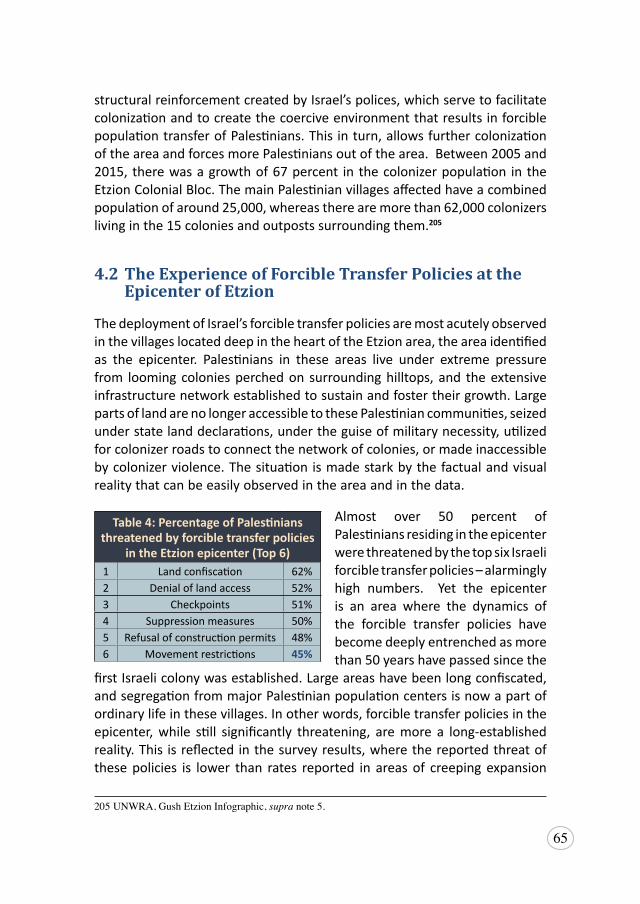
65
structural reinforcement created by Israel’s polices, which serve to facilitate colonization and to create the coercive environment that results in forcible population transfer of Palestinians. This in turn, allows further colonization of the area and forces more Palestinians out of the area. Between 2005 and 2015, there was a growth of 67 percent in the colonizer population in the Etzion Colonial Bloc. The main Palestinian villages affected have a combined population of around 25,000, whereas there are more than 62,000 colonizers living in the 15 colonies and outposts surrounding them.205
4.2 The Experience of Forcible Transfer Policies at the Epicenter of Etzion
The deployment of Israel’s forcible transfer policies are most acutely observed in the villages located deep in the heart of the Etzion area, the area identified as the epicenter. Palestinians in these areas live under extreme pressure from looming colonies perched on surrounding hilltops, and the extensive infrastructure network established to sustain and foster their growth. Large parts of land are no longer accessible to these Palestinian communities, seized under state land declarations, under the guise of military necessity, utilized for colonizer roads to connect the network of colonies, or made inaccessible by colonizer violence. The situation is made stark by the factual and visual reality that can be easily observed in the area and in the data.
Almost over 50 percent of Palestinians residing in the epicenter were threatened by the top six Israeli forcible transfer policies – alarmingly high numbers. Yet the epicenter is an area where the dynamics of the forcible transfer policies have become deeply entrenched as more than 50 years have passed since the
first Israeli colony was established. Large areas have been long confiscated, and segregation from major Palestinian population centers is now a part of ordinary life in these villages. In other words, forcible transfer policies in the epicenter, while still significantly threatening, are more a long-established reality. This is reflected in the survey results, where the reported threat of these policies is lower than rates reported in areas of creeping expansion
205 UNWRA,GushEtzionInfographic,supranote5.
Table 4: Percentage of Palestinians threatened by forcible transfer policies
in the Etzion epicenter (Top 6)1 Land confiscation 62%2 Denial of land access 52%3 Checkpoints 51%4 Suppression measures 50%5 Refusal of construction permits 48%6 Movement restrictions 45%
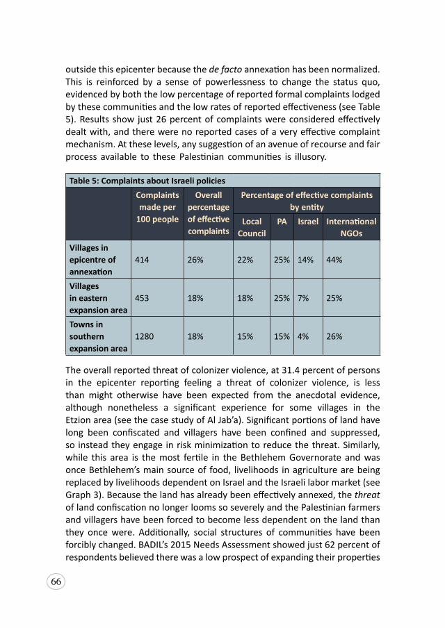
66
outside this epicenter because the de facto annexation has been normalized. This is reinforced by a sense of powerlessness to change the status quo, evidenced by both the low percentage of reported formal complaints lodged by these communities and the low rates of reported effectiveness (see Table 5). Results show just 26 percent of complaints were considered effectively dealt with, and there were no reported cases of a very effective complaint mechanism. At these levels, any suggestion of an avenue of recourse and fair process available to these Palestinian communities is illusory.
Table 5: Complaints about Israeli policiesComplaints made per
100 people
Overall percentage of effectivecomplaints
Percentage of effective complaintsby entity
LocalCouncil
PA Israel International NGOs
Villages in epicentre ofannexation
414 26% 22% 25% 14% 44%
Villages in easternexpansion area
453 18% 18% 25% 7% 25%
Towns in southernexpansion area
1280 18% 15% 15% 4% 26%
The overall reported threat of colonizer violence, at 31.4 percent of persons in the epicenter reporting feeling a threat of colonizer violence, is less than might otherwise have been expected from the anecdotal evidence, although nonetheless a significant experience for some villages in the Etzion area (see the case study of Al Jab’a). Significant portions of land have long been confiscated and villagers have been confined and suppressed, so instead they engage in risk minimization to reduce the threat. Similarly, while this area is the most fertile in the Bethlehem Governorate and was once Bethlehem’s main source of food, livelihoods in agriculture are being replaced by livelihoods dependent on Israel and the Israeli labor market (see Graph 3). Because the land has already been effectively annexed, the threat of land confiscation no longer looms so severely and the Palestinian farmers and villagers have been forced to become less dependent on the land than they once were. Additionally, social structures of communities have been forcibly changed. BADIL’s 2015 Needs Assessment showed just 62 percent of respondents believed there was a low prospect of expanding their properties
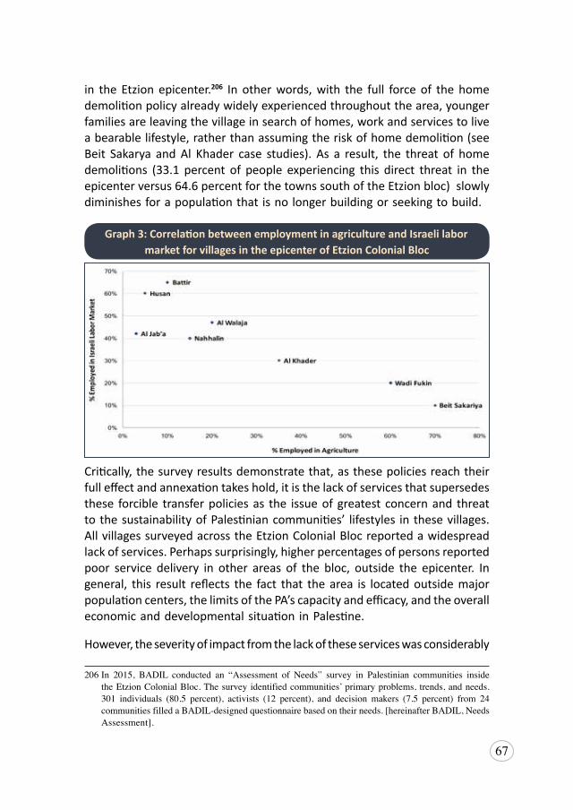
67
in the Etzion epicenter.206 In other words, with the full force of the home demolition policy already widely experienced throughout the area, younger families are leaving the village in search of homes, work and services to live a bearable lifestyle, rather than assuming the risk of home demolition (see Beit Sakarya and Al Khader case studies). As a result, the threat of home demolitions (33.1 percent of people experiencing this direct threat in the epicenter versus 64.6 percent for the towns south of the Etzion bloc) slowly diminishes for a population that is no longer building or seeking to build.
Critically, the survey results demonstrate that, as these policies reach their full effect and annexation takes hold, it is the lack of services that supersedes these forcible transfer policies as the issue of greatest concern and threat to the sustainability of Palestinian communities’ lifestyles in these villages. All villages surveyed across the Etzion Colonial Bloc reported a widespread lack of services. Perhaps surprisingly, higher percentages of persons reported poor service delivery in other areas of the bloc, outside the epicenter. In general, this result reflects the fact that the area is located outside major population centers, the limits of the PA’s capacity and efficacy, and the overall economic and developmental situation in Palestine.
However, the severity of impact from the lack of these services was considerably
206 In 2015, BADIL conducted an “Assessment of Needs” survey in Palestinian communities insidetheEtzionColonialBloc.Thesurveyidentifiedcommunities’primaryproblems, trends,andneeds.301 individuals (80.5 percent), activists (12 percent), and decision makers (7.5 percent) from 24 communitiesfilledaBADIL-designedquestionnairebasedontheirneeds.[hereinafterBADIL,Needs Assessment].
Graph 3: Correlation between employment in agriculture and Israeli labor market for villages in the epicenter of Etzion Colonial Bloc
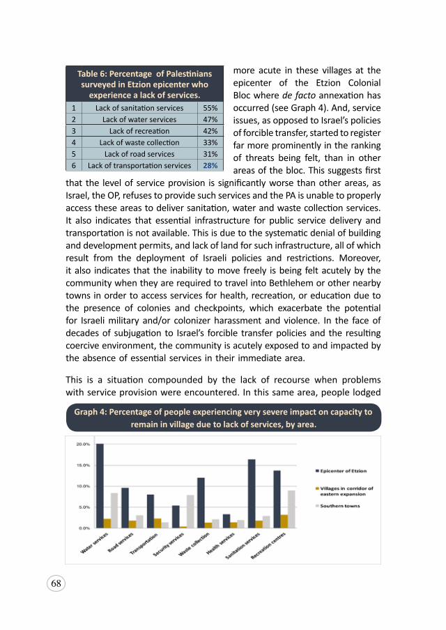
68
more acute in these villages at the epicenter of the Etzion Colonial Bloc where de facto annexation has occurred (see Graph 4). And, service issues, as opposed to Israel’s policies of forcible transfer, started to register far more prominently in the ranking of threats being felt, than in other areas of the bloc. This suggests first
that the level of service provision is significantly worse than other areas, as Israel, the OP, refuses to provide such services and the PA is unable to properly access these areas to deliver sanitation, water and waste collection services. It also indicates that essential infrastructure for public service delivery and transportation is not available. This is due to the systematic denial of building and development permits, and lack of land for such infrastructure, all of which result from the deployment of Israeli policies and restrictions. Moreover, it also indicates that the inability to move freely is being felt acutely by the community when they are required to travel into Bethlehem or other nearby towns in order to access services for health, recreation, or education due to the presence of colonies and checkpoints, which exacerbate the potential for Israeli military and/or colonizer harassment and violence. In the face of decades of subjugation to Israel’s forcible transfer policies and the resulting coercive environment, the community is acutely exposed to and impacted by the absence of essential services in their immediate area.
This is a situation compounded by the lack of recourse when problems with service provision were encountered. In this same area, people lodged
Table 6: Percentage of Palestinians surveyed in Etzion epicenter who
experience a lack of services.1 Lack of sanitation services 55%2 Lack of water services 47%3 Lack of recreation 42%4 Lack of waste collection 33%5 Lack of road services 31%6 Lack of transportation services 28%
Graph 4: Percentage of people experiencing very severe impact on capacity to remain in village due to lack of services, by area.
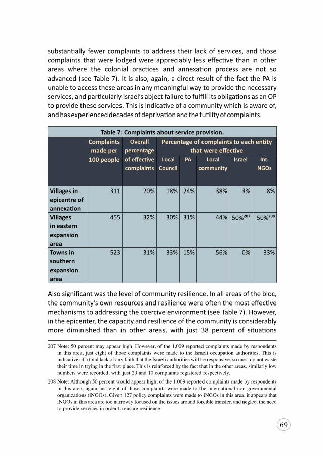
69
substantially fewer complaints to address their lack of services, and those complaints that were lodged were appreciably less effective than in other areas where the colonial practices and annexation process are not so advanced (see Table 7). It is also, again, a direct result of the fact the PA is unable to access these areas in any meaningful way to provide the necessary services, and particularly Israel’s abject failure to fulfill its obligations as an OP to provide these services. This is indicative of a community which is aware of, and has experienced decades of deprivation and the futility of complaints.207,208
Table 7: Complaints about service provision.Complaints made per
100 people
Overall percentage of effective complaints
Percentage of complaints to each entity that were effective
Local Council
PA Local community
Israel Int.NGOs
Villages in epicentre of annexation
311 20% 18% 24% 38% 3% 8%
Villages in eastern expansion area
455 32% 30% 31% 44% 50%207 50%208
Towns in southern expansion area
523 31% 33% 15% 56% 0% 33%
Also significant was the level of community resilience. In all areas of the bloc, the community’s own resources and resilience were often the most effective mechanisms to addressing the coercive environment (see Table 7). However, in the epicenter, the capacity and resilience of the community is considerably more diminished than in other areas, with just 38 percent of situations
207Note:50percentmayappearhigh.However,ofthe1,009reportedcomplaintsmadebyrespondentsin this area, just eightof those complaintsweremade to the Israeli occupation authorities.This isindicativeofatotallackofanyfaiththattheIsraeliauthoritieswillberesponsive,somostdonotwastetheirtimeintryinginthefirstplace.Thisisreinforcedbythefactthatintheotherareas,similarlylownumberswererecorded,withjust29and10complaintsregisteredrespectively.
208Note:Although50percentwouldappearhigh,ofthe1,009reportedcomplaintsmadebyrespondentsin this area, again just eightof those complaintsweremade to the internationalnon-governmentalorganizations(iNGOs).Given127policycomplaintsweremadetoiNGOsinthisarea,itappearsthatiNGOsinthisareaaretoonarrowlyfocusedontheissuesaroundforcibletransfer,andneglecttheneedtoprovideservicesinordertoensureresilience.
70
resolved effectively by the community themselves, as opposed to 44 and 56 percent in the other areas. This is undoubtedly a reflection of the intensity of the coercive environment these communities experience, and is emblematic of a situation that is increasingly compelling the transfer of the population.
The results of this survey in the epicenter are deeply concerning. On the one hand, they reflect the extent to which annexation and the status quo has taken hold in this area, given the results are nonetheless widespread. As discussed, these communities lodge fewer complaints, have experienced lower effective responses, and have been confined and contained to significant degrees through restrictive Israeli movement, development, access and service policies. On the other hand, the entrenchment of annexation in the epicenter is due to the virtually ineffective and/or absence of adequate interventions by the responsible authorities – principally Israel and the international community. The data clearly confirms Israel’s abject failure as an OP to meet its obligations to fulfill the needs and rights of the protected Palestinian population. Further, the presence of the international community, in the form of international non-governmental organizations (iNGOs) is practically absent with only eight percent of service complaints dealt with effectively (Table 7) and 44 percent of policy complaints relating to forcible transfer (Table 5) addressed in an effective manner. While the latter percentage may appear to be significant, it must be taken into consideration that iNGOs were the recipients of the fewest complaints after the Israeli authorities (just 36 of 929 policy complaints were made to iNGOs in this area), suggesting their reach and presence in the area is highly limited. As such, these communities by their responses have indicated feelings of resignation and abandonment. They are left with little alternative but to evolve or leave.
Al Walaja
The village of Al Walaja is located northwest of Bethlehem, and hosts a population of 2,761 Palestinians.209 Historically, much of the village had been located west of the Green Line, with a history dating back at least as far as 1596, when it first appeared on Ottoman tax registers.210 Back then, it paid taxes on a number of crops, such as wheat, barley, olives and fruits, as well
209PCBS,”LocalitiesinBethlehemGovernoratebyTypeofLocalityandPopulationEstimates”,2016,available at http://www.pcbs.gov.ps/Downloads/book2364.pdf [accessed 20 June 2019] [hereinafterPCBS, Population Estimates].
210WalidKhalidi(ed.),All that Remains: The Palestinian Villages Occupied and Depopulated by Israel in 1948,(WashingtonDC,1992),322.
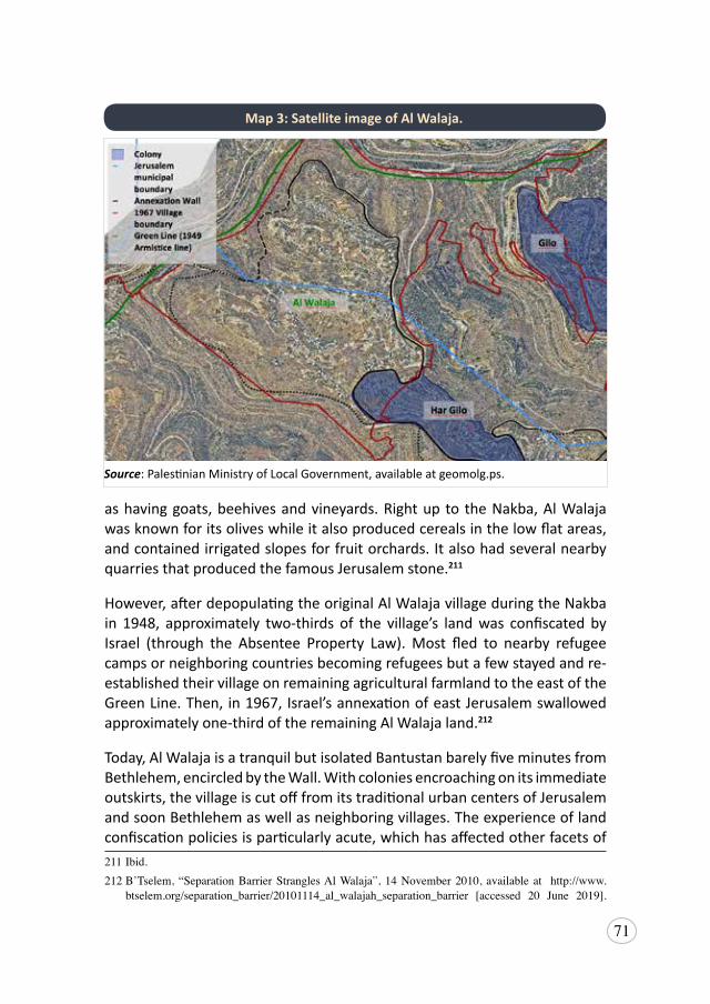
71
as having goats, beehives and vineyards. Right up to the Nakba, Al Walaja was known for its olives while it also produced cereals in the low flat areas, and contained irrigated slopes for fruit orchards. It also had several nearby quarries that produced the famous Jerusalem stone.211
However, after depopulating the original Al Walaja village during the Nakba in 1948, approximately two-thirds of the village’s land was confiscated by Israel (through the Absentee Property Law). Most fled to nearby refugee camps or neighboring countries becoming refugees but a few stayed and re-established their village on remaining agricultural farmland to the east of the Green Line. Then, in 1967, Israel’s annexation of east Jerusalem swallowed approximately one-third of the remaining Al Walaja land.212
Today, Al Walaja is a tranquil but isolated Bantustan barely five minutes from Bethlehem, encircled by the Wall. With colonies encroaching on its immediate outskirts, the village is cut off from its traditional urban centers of Jerusalem and soon Bethlehem as well as neighboring villages. The experience of land confiscation policies is particularly acute, which has affected other facets of 211Ibid.212 B’Tselem, “SeparationBarrierStranglesAlWalaja”,14November2010, available at http://www.
btselem.org/separation_barrier/20101114_al_walajah_separation_barrier [accessed 20 June 2019].
Source: Palestinian Ministry of Local Government, available at geomolg.ps.
Map 3: Satellite image of Al Walaja.
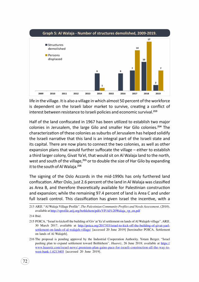
72
life in the village. It is also a village in which almost 50 percent of the workforce is dependent on the Israeli labor market to survive, creating a conflict of interest between resistance to Israeli policies and economic survival.213
Half of the land confiscated in 1967 has been utilized to establish two major colonies in Jerusalem, the large Gilo and smaller Har Gilo colonies.214 The characterization of these colonies as suburbs of Jerusalem has helped solidify the Israeli narrative that this land is an integral part of the Israeli state and its capital. There are now plans to connect the two colonies, as well as other expansion plans that would further suffocate the village – either to establish a third larger colony, Givat Ya’el, that would sit on Al Walaja land to the north, west and south of the village,215 or to double the size of Har Gilo by expanding it to the south of Al Walaja.216
The signing of the Oslo Accords in the mid-1990s has only furthered land confiscation. After Oslo, just 2.6 percent of the land in Al Walaja was classified as Area B, and therefore theoretically available for Palestinian construction and expansion; while the remaining 97.4 percent of land is Area C and under full Israeli control. This classification has given Israel the incentive, with a
213ARIJ,“AlWalajaVillageProfile”,The Palestinian Community Profiles and Needs Assessment, (2010),availableathttp://vprofile.arij.org/bethlehem/pdfs/VP/Al%20Walaja_vp_en.pdf
214Ibid.215POICA,“IsraeltokickoffthebuildingofGiv’atYa’elsettlementonlandsofAlWalajehvillage”,ARIJ,
30 March 2017, available at http://poica.org/2017/03/israel-to-kick-off-the-building-of-givat-yael-settlement-on-lands-of-al-walajeh-village/ [accessed 20 June 2019] [hereinafter POICA,SettlementonlandsofAlWalajeh].
216The proposal is pending approval by the Industrial CooperationAuthority.Yotam Berger, “Israelpushingplan toexpandsettlement towardBethlehem”,Haaretz,26June2018;availableathttps://www.haaretz.com/israel-news/.premium-plan-gains-pace-for-israeli-construction-all-the-way-to-west-bank-1.6213405 [accessed 20 June 2019].
Graph 5: Al Walaja - Number of structures demolished, 2009-2019.
73
guise of legality, to manipulate planning and zoning laws, justify imposition of permits, and prevent the upkeep and expansion of the village to meet demand. This all contributes to the creation of a coercive environment that forces the population to leave. For example, virtually unattainable building permits from the Israeli Civil Administration have resulted in more than 75 buildings in Al Walaja becoming subject to demolition orders up to 2016.217 This is the precursor to demolition and displacement, which has dramatically increased in Al Walaja in the last five years, with 30 structures demolished, including ten homes demolished in 2018,218 39 people displaced and 121 others affected by the demolitions (see Graph 5).219
In 2006, construction of the Wall commenced, further cutting off many residents of Al Walaja from their lands behind the Wall, denying them access to their farmland and livelihoods. Six and half kilometers of the Wall runs through Al Walaja village, leaving just 11 percent of pre-1948 village land and 46 percent of post-1948 village land readily accessible to the villagers.220 Though, by reason of a High Court decision, Israel has been required to construct agricultural gates along the Wall, through which farmers must pass in order to access their land.221
“Israelconfiscatedaround600or700[meters]ofmylandtobuildtheWall,anduprooted180oliveandpeachtrees.AsforthelandbehindtheWall,theyconfiscatedaroundtendunums[...].Theyhaven’tyetaskedmeforapermittoaccessmyland[behindtheWall],butIdon’tknowwhatmighthappenwhentheyfinishthegate.IrefusetoapplyforapermitbecauseitwouldonlymeanthatIhavelostmylandandIagreetomylandbeingconfiscated.I’mnotastrangerhere,thisismylandandIshouldn’tneedapermittoaccessit.ItoldthemIwillrefusethegateunlesstheygivemeakeytoit[…]They’realreadybuildingallthenecessaryinfrastructure:thecameras,andthebarriersforthegate,buttheyhaven’tfinishedyet[…]
217OCHA,Israeli Demolition Orders Against Palestinian Structures in Area C, 1988-2016 (infographic),n.d.,availableathttp://data.ochaopt.org/demolitions/index.aspx?id=311650[accessed20June2019][hereinafterOCHA,IsraeliDemolitionOrders].
218IMEMC,“189HomesStillFaceThreatofDemolitioninAl-Walaja”,4September2018,availableathttps://imemc.org/article/189-homes-still-face-threat-of-demolition-in-al-walaja/[accessed20June2019].
219OCHA,Data on demolition and displacement in the West Bank (infographic),n.d.,availableathttps://bit.ly/30iNWhS[accessed20June2019].
220NasserAlQadi,Al- Walaja: The Reality of Geopolitical Isolation, ARIJ,21February2018,8,availableathttp://poica.org/wp-content/uploads/2018/02/alwalajah.pdf
221 UNWRA, “Mini Profile:AlWalaja”, January 2012, 1, available at http://www.europarl.europa.eu/meetdocs/2009_2014/documents/droi/dv/910_aiwalaja_/910_aiwalaja_en.pdf
74
TheWall separates us from theold road to the city: it used to takeusfiveminutestogettoBeitJala[atowninGreaterBethlehem],nowwehavetogoallthewayaroundthevillagetothehighway,andthentoBeitJala,whichtakesaroundhalfanhour.TheWallalsodisconnectedusfromourneighborsandthepeoplewhousedtoworkwithus.Theimpactispsychologicalmorethanphysical.Whenyou’resittinginyourownhomeandyouseeaWallfromthewindow,youfeelthatyou’reinaprisonbutatleastimprisonmenthasadateof release, thisprison ispermanent. It’smakingusdepressedandfrustratedtoseeJerusalemfromourwindowandnotbeabletogothere.Alsowedon’tknowwhat’sgoingtohappentous,ourfutureisunknown,thefutureofallPalestiniansisunknown,notonlyofmineandmyfamily[…]
IsraelismakinglifeharderinAlWalajabecausetheywantpeopletoleavethevillage,theywanttohumiliateus.Ifsomeonealreadyhasahomeheretheymostprobablywon’tleave,butthosewhocan’tbuildortheirhomeshavebeendemolishedhavenooptionbuttoleavethevillageandmanypeoplehave.Mybrother,forexample,theydemolishedhishome[behindtheWall]beforehestartedlivinginitandnowhe’slivinginBeitJala.”
Abu Nidal, farmer from Al Walaja. Interview: Al Walaja on 12 October 2017
Results from the 2015 Needs Assessment,222 revealed that 77 percent of Palestinians surveyed believe that their villages and communities within the Etzion Colonial Bloc have been isolated and segregated from their land as a result of the Wall. More than cutting access to livelihoods, Israel’s oppressive policies of land confiscation are also undermining the right of Palestinians to self-determination and territorial integrity. In its fragmentation and appropriation of Palestinian land, Israel is attacking Palestinian social cohesion and collectivity. Communities are fractured, encircled and displaced, creating fissures within and between family and community units, weakening their collective identity. The Israeli plan is to completely encircle Al Walaja, and construct a gate controlled by a military checkpoint that will be the only way in and out.223 This policy of segregation, where residents in Al Walaja are isolated from cities like Beit Jala and Jerusalem and from other Palestinians,
222 BADIL,NeedsAssessment,supra note206.223 Itisworthnotingthatasof11November2017,IsraelhasannouncedthatitwillmovetheEinYael
checkpointlocatedinnorthernAlWalajadeeperintothevillage.ThiswillconfiscateallPalestinianlandsbeyondthecheckpoint,andrendertheEinHaniyaspringinaccessibletoWestBankIDholders.See“IsraeltoMoveCheckpointFurtherIntoAlWalaja,CuttingVillagersOffFromSpring”,Ma’an News Agency,17November2017,availableathttps://www.maannews.com/Content.aspx?id=779487[accessed20June2019].
75
results in deeper pressure for residents to leave their villages, as illustrated by another testimony from the village.
“All of those policies implemented in Al Walaja will lead to forciblytransferringtheresidents.Ifaworkerhastoleaveat4:00ameverymorningtogettoworkhowcanhegettoworkontimeifthegateisonlyopenat7:00am?Hewillnotgetthereontime.Also,studentswhogotouniversitiesinplaceslikeRamallahwillnotbeabletobethereon-timefortheirlectures.EveryonefromAlWalajawillsufferfromthegatethattheyplantobuildatthevillageentrance.PeoplewilllookforalternativesandliveinBeitJalaorBethlehem,whichwillonlymakethesituationinthisvillageworse.Peoplearealreadyleavingthevillage[...]
ThemoreIsraelconfiscatesourlandandimplementsitscoercivepolicesonus,themorewewillhavesocialandeconomicdifficulties.Fortheresidentsofthevillage,Einal-Haniyaspringsusedtobeouropenandpublicspace,notonlyforus,butalsoforthewholeofBethlehemandWestBank.Whenpeoplearedeniedaccesstothisareatheywilllosehopeaswell.Canyouimaginehowwewillfeelwhenweareonlyabletolookatourmountainsandwaterspringsfromadistanceandaredeniedaccesstothem?Thiswillaffectpeoplesomuch[...]Eventually,peoplewillnotbeabletoaccesstheirland,theywillbeonlyabletolookatitfromadistance…”
Khader al-A’raj, member of Al Walaja village council. Interview: Al Walaja on 9 October 2017
In addition to confiscating land and segregating the population, the village of Al Walaja is also subjected to Israel’s systematic policy of denial of access to its natural resources. Ein al-Haniya springs located in Al Walaja were an important freshwater source for Palestinians in the West Bank. These particular springs are the second largest in the West Bank, and were a key water source for livestock and a rare and popular recreation space for villagers of Al Walaja and surrounding areas, including residents of Bethlehem.224
However, Military Orders 92 and 158, both issued in 1967, put all water-related issues in the oPt under Israeli control, including the construction of new water infrastructure, which requires a permit from the army that is rarely granted.225 Under the Oslo Accords, the PA was given no authority to build new or upgrade existing water infrastructure, allocating Israel total decision-
224 Ibid. 225 Ibid.
76
making power over water extraction from wells and springs in the oPt.226 Today, Israel controls 85 percent of water in the oPt, which it discriminatorily allocates for the benefit of Israeli-Jewish colonizers.
In the case of Ein al-Haniya, Israel has confiscated the springs and the land surrounding them and, in January 2018, formally declared it a nature park and part of the Rephaim Valley National Park.227 In recent years, Palestinian access to the springs has been heavily restricted due to the presence of Israeli police that guard Israeli colonizers using the springs for recreational purposes. Further, since January 2018, Israel has been constructing a new checkpoint to the west of Al Walaja village, which will cut off Palestinian access to the springs altogether. Instead access to this natural resource for Palestinians is heavily restricted, and rather it has become a popular recreational spot for Israeli-Jewish colonizers from nearby colonies.
“Thereare24waterspringsinAlWalaja.ThebiggestoneisEinal-Haniya.Inthelasttwoyears,Israelishave[…]changedthewholearea.TheybuiltnewstructuresanddemolishedoldPalestinianhomes,theychangedthelandandchanged thenatural lookof thearea.Nowwhenwe seeEinal-Haniya, it’sstrange,it looksnothinglikewhatweusedtoseetwoyearsago.Asfortheotherwatersprings,therearetwoinsidethevillageitself,Einal-HadafandEinal-Jewizza,but,asaresultoftheconstructionoftheWall,thedirectionofthewaterchangedandtheynolongerhavewaterinthem.[…]TheEinal-JewizzaspringisclosedbecauseIsraeliskeptcomingtothespring,claimingthatithassomehistoricalJewishorigin,sotheresidentsclosedittopreventIsraelisfromcomingtotheareaandconfiscatingit.AllourwaterspringsshouldbelikeEinal-Haniyaspring,whichprovideswaterallwinterandsummer,andhasstrongpressuretoo,buttherealityisdifferent,thewaterspringsinAlWalajaaresoweak.TherearemanyotherspringsinAlWalajabuttheyarelocatedinsidethe1948borders,mostofthemusedbyIsraelis,whositandhavepicnicsaroundthem.
Khader al-A’raj, member of Al Walaja village council. Interview: Al Walaja on 9 October 2017
226 Amnesty International,Troubled Waters - Palestinians Denied Fair Access to Water, 27 October2009,MDE 15/027/2009,17, available at http://www.refworld.org/docid/4ae6af020.html[accessed20 June 2019] [hereinafterAmnesty International, TroubledWaters].
227MichaelBachner,“FirstTemple-erarelicsofpossibleroyalestatefoundinJerusalemhills”,The Times of Israel, 31 January 2018, available at https://www.timesofisrael.com/first-temple-era-relics-of-possible-royal-estate-found-in-jerusalem-hills/ [accessed 20 June 2019].
77
The denial of access to water in the West Bank has resulted in inadequate water supply for Palestinians, forcing the PA and Palestinians to buy water from Mekorot, Israel’s national water company.228 Today, the PA relies on Mekorot for almost half of the West Bank’s domestic water.229 In the Etzion Colonial Bloc, specifically, 70 percent of Palestinian homes rely on water from Mekorot, while the remaining 30 percent depend heavily on purchasing water from mobile water tanks, or collecting water from cisterns in areas that are at risk of demolition.230 Furthermore, Mekorot reduces Palestinian water supply by up to 50 percent in the summer in order to maintain comfortable allocation to Israeli colonies.231
In villages like Al Walaja, the denial of access to natural resources coupled with the permit regime pose major obstacles for Palestinians, both in terms of accessing drinking water, cultivating their agricultural land, and providing a water source for livestock. The testimonies above underscore not only the physical impact that Israeli policies have on the land and natural resources, but also that the combination of these policies has both social and psychological effects on the residents of the village. This is indicative of how the annexation of territory occurs in tandem with forcible transfer.
Beit Sakarya
Beit Sakarya is a small village of 142 people,232 situated southwest of Bethlehem, surrounded by some of the oldest Etzion colonies. The village itself also consists of four outlying villages, Khallet al-Ballutah, Khallet ‘Afana, Ash Shifa, and Wadi Shkheet, all of which face similar conditions to that of
228 ‘Mekorot’wasfoundedin1937asajointventurebetweentheJewishAgency, theJewishNationalFund and a ‘Histadrut’ (trade union association) subsidiary company to provide water for Jewish settlementsinsupportoftheZionistmovement.After1948,‘Mekorot’becametheofficialIsraeliWaterAuthorityandfellunderthejointownershipoftheGovernmentofIsraelanditsoriginalfounders.SeeCentreonHousingRightsandEvictions(COHRE)andBADIL,Ruling Palestine: A History of the Legally Sanctioned Jewish-Israeli Seizure of Land and Housing in Palestine, (2005): 46, availableat http://www.badil.org/phocadownloadpap/Badil_docs/publications/Ruling per cent20Palestine.pdf [hereinafterBADIL,RulingPalestine].
229 ElizabethKoeth,Water for One People Only: Discriminatory Access and ‘Water-Apartheid’ in the OPT,Al-Haq,(2013):45,availableathttp://www.alhaq.org/publications/Water-For-One-People-Only.pdf [hereinafterKoeth,WaterApartheid].
230 BADIL,NeedsAssessment,supra note206;Accordingly,AmnestyInternationalhasreportedthatcisternswereeitherdestroyedorawaitingpendingdestructionbytheIsraeliarmyinthemajorityofvillagestheyvisitedintheWestBank,SeeAmnestyInternational,TroubledWaters,supra note226,44.
231 Koeth,WaterApartheid, supra note229,48.232PCBS,2017Census,supra note6.
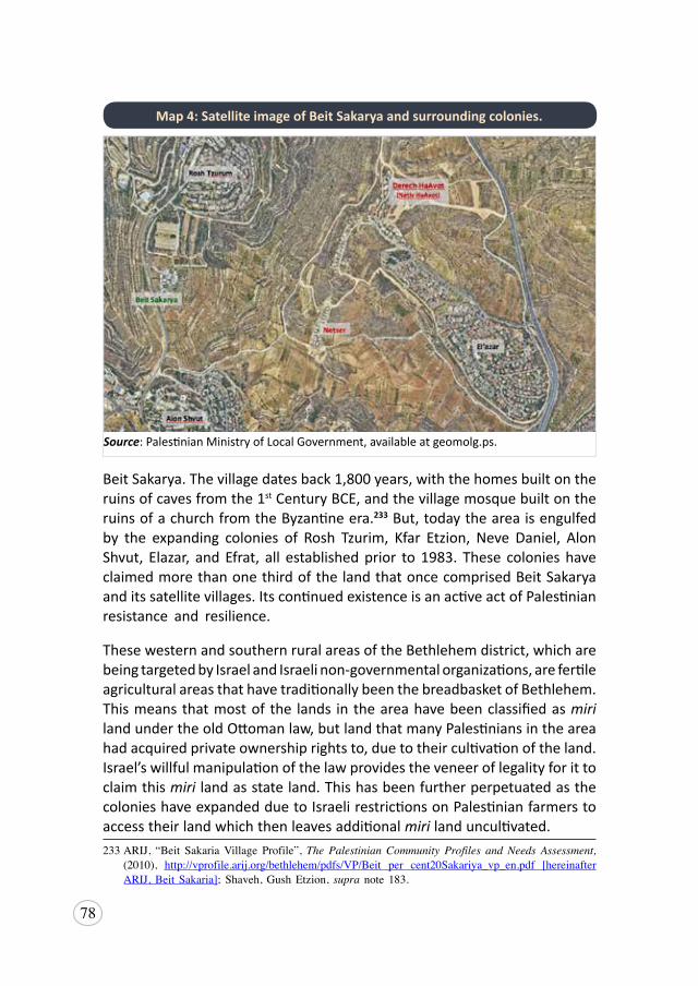
78
Beit Sakarya. The village dates back 1,800 years, with the homes built on the ruins of caves from the 1st Century BCE, and the village mosque built on the ruins of a church from the Byzantine era.233 But, today the area is engulfed by the expanding colonies of Rosh Tzurim, Kfar Etzion, Neve Daniel, Alon Shvut, Elazar, and Efrat, all established prior to 1983. These colonies have claimed more than one third of the land that once comprised Beit Sakarya and its satellite villages. Its continued existence is an active act of Palestinian resistance and resilience.
These western and southern rural areas of the Bethlehem district, which are being targeted by Israel and Israeli non-governmental organizations, are fertile agricultural areas that have traditionally been the breadbasket of Bethlehem. This means that most of the lands in the area have been classified as miri land under the old Ottoman law, but land that many Palestinians in the area had acquired private ownership rights to, due to their cultivation of the land. Israel’s willful manipulation of the law provides the veneer of legality for it to claim this miri land as state land. This has been further perpetuated as the colonies have expanded due to Israeli restrictions on Palestinian farmers to access their land which then leaves additional miri land uncultivated. 233ARIJ, “Beit SakariaVillage Profile”,The Palestinian Community Profiles and Needs Assessment,
(2010), http://vprofile.arij.org/bethlehem/pdfs/VP/Beit per cent20Sakariya_vp_en.pdf [hereinafterARIJ,Beit Sakaria]; Shaveh,GushEtzion, supra note 183.
Source: Palestinian Ministry of Local Government, available at geomolg.ps.
Map 4: Satellite image of Beit Sakarya and surrounding colonies.
79
Troublingly, the majority of Palestinians living in these areas work in agriculture, which makes the land their main source of income. In Beit Sakarya, particularly, more than 70 percent of villagers are dependent on agriculture for their livelihood. As a consequence, the Israeli policy of land confiscation and denial of use is one of the most significant challenges that Palestinian villagers and communities encounter, because it results in the absolute destruction of livelihoods for many of those affected.
“Theeconomicsituationingeneraldependsonfarming[…]ourlandsdependonlyonrainwaterbecausewehavenootherwatertouse.Wehavegrapes,olives,andalmonds,butwehavenowater.
[…]sowedependonlyonourlivestock.Becauseofthis,Icansaythatthesituationofa farmerhere isbeneathzero[…]Oursituation ismadeharderbecausewealsohavea residentialproblem.Familiesare fromfive toeightmembers:canyouimagineallofthemlivinginoneroom?Thepsychologicalsituationhereissodifficult,whatdoyouexpectwhenamancan’tevenhaveaprivateconversationwithhiswife?Whatisthislife?
Thisvillagehadapopulationof650people:itiscomprisedoffivedifferentfamilies. Unfortunately, the population is increasing everywhere else, anddecreasing in our village.We have many young people who want to startfamilies, but they don’t have places to live once they getmarried, so theyleaveBeitSakarya.Inthepasttwoorthreeyears,38coupleshaveleftanditreallyhurtsmetosaythisoreventhinkaboutit,butthisisourreality[...]Tobehonestwithyou,Iprefersayingthateventuallythingswillbebetter,andhopefullywewillbeallowedtobuildinourvillageoneday.Weonlyliveonhope,butstillpeopleherefromaveryyoungagestartthinkingabouthowandwhentoleavethevillage.”
Mohammad Atallah, member of Beit Sakarya village council. Interview: Beit Sakarya, 11 October 2017
This testimony points to the Israeli policy of the denial of access to natural resources like land and water, a policy that directly impacts Palestinian farmers. An estimated 55 percent of Palestinians in the Etzion Colonial Bloc expressed fear of Israeli demolition of their rainwater collection wells on their agricultural lands. This is because construction of water wells for Palestinians is prohibited and Israel monitors the area on a regular basis.234 The dependence of farmers in Beit Sakarya on rainwater, or on Merokot,
234Ibid.
80
which systemically prioritizes water allocation to Israeli colonies, leaves them without a reliable water source and thus economically unstable. The scarcity of water availability for residents of Beit Sakarya is borne out in the fact that their rate of water consumption in 2010 was estimated to be just 40 liters a day per person,235 well short of the 50-100 liters a day recommended by the World Health Organization (WHO), as necessary to ensure that most basic needs are met and few health concerns arise.236 In contrast, according to Israeli statistics, in 2012, Israeli colonizers were allocated 367 liters per day.237
Further compounding this situation, after Oslo, the village was classified entirely as Area C, allowing Israel to exercise full military and administrative control over the land of Beit Sakarya.238 This categorization is indicative of the long-held intent Israel has to claim the land of Beit Sakarya. As with Al Walaja, this demarcation further facilitates the imposition of other forcible transfer policies, which serve to create an extreme coercive environment that forces residents to leave. Discriminatory planning and zoning, together with a complex system of permits, led to the pervasive practice of home demolitions and is particularly evident in Israel’s inventory of practices deployed in Palestinian villages.
Beit Sakarya is a village of just 36 homes, along with a number of agricultural structures, a small shop, a school and a mosque.239 Yet, in 2016, 31 homes were estimated to be the subject of demolition orders, with a total of 73 structures in the village either the subject of looming demolition orders, or already demolished due to the absence of an Israeli permit.240 This includes the village school, one of approximately 50 schools in the West Bank to have a pending demolition order.241 Since 1967, there has been no Israeli approved renovation or development inside the village, and many villagers are forced to live in one room homes, or with spaces that double up as the kitchen and
235Ibid. 236OHCHR,UNHabitat,WHO,Fact sheet No 35: The Right to Water,8,availableathttps://www.ohchr.
org/Documents/Publications/FactSheet35en.pdf237The allocation for Israeli colonizers was reported to be 134 m3/year per capita, this converts to
367 liters per day for each Israeli colonizers: seeTheCivilAdministration of Judea andSamaria,Factsheet: Water in the West Bank,2012,5,availableathttps://reliefweb.int/sites/reliefweb.int/files/resources/3274.pdf
238ARIJ,BeitSakaria,supra note233.239Ibid.240OCHA,IsraeliDemolitionOrders,supra note217.241OCHA,“WestBankdemolitionsanddisplacement-December2018”,17January2019,availableat
https://www.ochaopt.org/content/west-bank-demolitions-and-displacement-december-2018 [accessed20June2019][hereinafterOCHA,WestBankDemolitions2018].

81
bedroom. The conditions are often too oppressive for growing families and people are forced to build despite the risk of demolition, or leave.
“We left thevillagebecausewewerenot allowed tobuild.Wewere livinginonesmallroomwithmyfirstdaughter.Whenweleftshewasthree.Igotpregnantwithmyseconddaughter,andtheypreventedusfromexpandingthehouse[...]Thereareotherswhohavealsoleftthevillage,likemybrotherinlaw,whoislivinginthesamebuildingwithus[nowinAlKhader].Helivedinthevillageforfouryearswithhiswife:theroomstheylivedinwereinpoorcondition,andtheyalsohadchildren.Thekitchenwasinsidethebedroom.Itwasreallybad,sotheyhadtomove.Mysisteraswell,shemovedfromBeitSakarya.Shewaslivingwithmymother,shewasawidowandwhenshegotre-marriedshemovedtoDoha.
Wetriedsohardtobuild inBeitSakarya,butwealsowitnessedthosewhodid:theyreceiveddemolitionorders,gotcalledtocourts,andhadtopayfines.Anynewhome,anynewbrickwillreceivedemolitionordersandfines,andtheneventuallygetdemolished[...].Comingtoandrenovatingthishome[inAlKhader]wasourlastchoice.IfIhadhadevenonepercentchancetostayinthevillage,Iwouldhavestayed.Weweresoclosetoriskingitandbuying
Graph 6: Beit Sakarya - Home demolition orders issued per year. (Jan. 1988 - Apr. 2017)
Source: OCHA, Demolition Orders against Palestinian Structures in Area C – Israeli Civil Administration data.
82
landinBeitSakarya,butthereissolittlelandorspacewhereweareallowedtobuild[…].
Iused to liveamongmycommunityandaroundmyfamilybuthere [inAlKhader], I don’t know anyone to be honest. I’ve been here for nine years,andIstilldon’tknowmyneighborsbecauseIdon’thaverelationshipswithanyone.Twoweekscanpasswithoutmevisitingmymother.Mydaughtersareinschoolandmyhusbandcomesbackfromworkat7pm,soIcan’tgotoBeitSakaryabecausethereisnopublictransportation.It’shardtogettothevillagethesedays,evenwithaprivatecarbecauseofthecheckpoint[…].242Ineverthoughtaboutgoingbacktothevillage,it’sjustsofarawayfromourreality,andthefactthatIdon’thaveahometherepreventsmefromthinkingof returning […].
Israel isdoingallof this [thecoerciveenvironment]onpurpose.There isawholegenerationwhohaveleftthevillageandthecomingonewillalsoleave.Ifanyonewantstobuildrooms,itwillcauseproblems,andpeoplearerunningawayfromthehassle.Imeanpeopleshouldbeabletochoosetobuildahomeandestablishastablelife,notbeforcedtospendtheirwholelifegoingbackandforthbetweencourts.Israelisdoingthisonpurposebecausetheywantusoutofourvillage.Theoldergenerationwilleventuallydie,andtheyoungergenerationhasalreadyleftthevillage,sonoonewillremainonthisland.Theywanttotakeourlands,evenmygrandfather’slandsacrossthemainstreet;ofcourse,theydon’tcare,theykeepbuildingonourlandandthisaffectsussomuch.Ifyoulookattheirsituationandlifeandatourhomes,wouldn’titmakeyoufeeldefeated?”
Mariam Saad, former resident of Beit Sakarya. Interview: Al Khader, 8 November 2017
By 1986, 50 percent of the land in the West Bank had already been expropriated by Israel either as “state land” or by unfounded military necessity,243 so home demolitions and building permit restrictions become key tools by which Israel asserts a coercive environment. Prior to the signing of the Oslo Accords, demolition orders against Palestinian structures were issued at a rate of approximately 49 per year; by 2014, this rate had skyrocketed to 966 orders issued per year.244 In the Bethlehem governorate, the geographic location illuminates the strategic objective of these orders, with almost a third (410)
242 ThecheckpointMariamreferstoislocatedinsouthwestBethlehem.243Abdulhadi,LandUse,supra note154, 46. 244OCHA,WestBankDemolitions2018,supra note241,8.
83
of the governorate’s 1,380 demolition orders targeting structures in this area of the Etzion Colonial Bloc.245 In Beit Sakarya, specifically, residents have experienced demolitions of their homes and other essential structures, including water wells, in 2007, 2009, 2011 and 2013. At the same time, any construction of new structures or restoration of existing structures all require Israeli permits, which are rarely given.246
As part of Israel’s policy of discriminatory zoning and planning, these actions infringe upon the social rights of Palestinians as defined by the UN Universal Declaration of Human Rights,247 and more specifically, result in a violation of the right to adequate housing protected by international law.248 In relation to Area C, which constitutes more than 60 percent of the West Bank, less than one percent is assigned for Palestinian development.249 Palestinian communities living in these areas are denied the capacity to build new homes or expand their existing ones, and unlawful demolitions serve to grievously erode the quality of life. This situation renders life exceedingly difficult as families continue to grow, and exemplifies how these policies result in a steady and relentless process of forcible transfer.
“[…]It’shardtogettothevillagethesedays,evenwithaprivatecar,becauseofthecheckpoint.IusedtogotheEtzionjunctionandanyonefromthevillagewouldjustcomeandpickmeupintheircar.Now,noonecangotothejunction,ifyoustandthere,[soldiers]willshootyou.So,thetransportationsituationisreallybad,theideaofgoingtothevillageisdifficultthesedays.
Iusedtovisitmymother[inBeitSakarya]onceaweek,butnowthereisnotransportationtothevillageandwhenIaskaprivatetaxitotakemethere,theyoftenrefusemakingithardtovisit.WehaveonlyonedriverwhowilldrivethroughEtzionjunction,ifhe’sfreehewillcomeandtakeustothevillage.ButIalsonowhavefourdaughtersandataxionlyfitsfour,otherthanthedriver,whichmeanswehaveanextrapassengeranddriversgetscaredoftheIsraelipoliceandrefusetotakeus.
245Ibid,11.246 ARIJ,BeitSakarya,supra note133.
247UDHR,supranote47,art.22.248 Art.11(1)oftheInternationalCovenantofEconomic,SocialandCulturalRights;UNCommitteeon
Economic,SocialandCulturalRights(CESCR),“GeneralCommentNo.4:TheRight toAdequateHousing (Art 11 (1) of the Covenant)”, 13 December 1991, available at http://www.refworld.org/docid/47a7079a1.html [accessed 20 June 2019].
249 OCHA,“AreaC-WestBank:KeyHumanitarianConcerns”,21 December 2017,1,availableat https://www.ochaopt.org/content/west-bank-area-c-key-humanitarian-concerns [accessed20June2019].
84
Iwould love tohaveahome in thevillage.Myhusbandstays lateatworka lot, sometimesonFridaysandSaturdayshefinishesat9pm.MyhusbandworksinthecolonyEtzion[KfarEtzion].IfI’minthevillageonaFridayorSaturday,weareforcedtowaitformyhusbandbeforewecangobackhometoAlKhader,whichcouldbeafter10pm.Ifwehadahomeinthevillagewewouldstay there.”
Mariam Saad, former resident of Beit Sakarya. Interview: Al Khader, 8 November 2017
Ultimately, the Israeli policy of segregation carries detrimental social impacts on the residents of Beit Sakarya. Segregation may happen before forcible transfer occurs, where, for example, Palestinians are separated from one another by the Wall, which results in ensuing movement restrictions. Or, as a result of forcible transfer, individuals become isolated from their families and communities back home. The combination of oppressive Israeli policies implemented in Beit Sakarya has an intergenerational impact, and the social cohesion of the village are collectively weakened as each resident or family member is forced to leave.
Al Khader
Al Khader is a small town located southwest of Bethlehem, with a population of 12,301 Palestinians.250 Its residential area adjoins the built-up area of Bethlehem, while the agricultural lands, which have always been a primary source of livelihood for the residents, lie in the area that today form part of the Etzion Colonial Bloc. These lands, categorized as Area C and comprising 85.5 percent of the town’s land, are now cut off from the residents by the Wall, which itself involved the confiscation of more Al Khader land by numerous military orders issued between 2000 and 2011.251 The seizure of land from Al Khader started in the late 1970s, when several thousand dunums of the village land were confiscated by military order to establish the Efrat and Neve Daniel colonies. This seizure was later converted to a state land declaration following an Israeli survey of West Bank land in the late 70s and early 80s.252
With construction of the Wall, only 2,600 dunums (or approximately 12
250 PCBS,PopulationEstimates,supra note,209.251ARIJ,“AlKhaderTownProfile”,The Palestinian Community Profiles and Needs Assessment, (2010),
21-22,availableathttp://vprofile.arij.org/bethlehem/pdfs/VP/Alpercent20Khader_tp_en.pdf252PeaceNow,SettlementsonSeizedLand,supra note68.
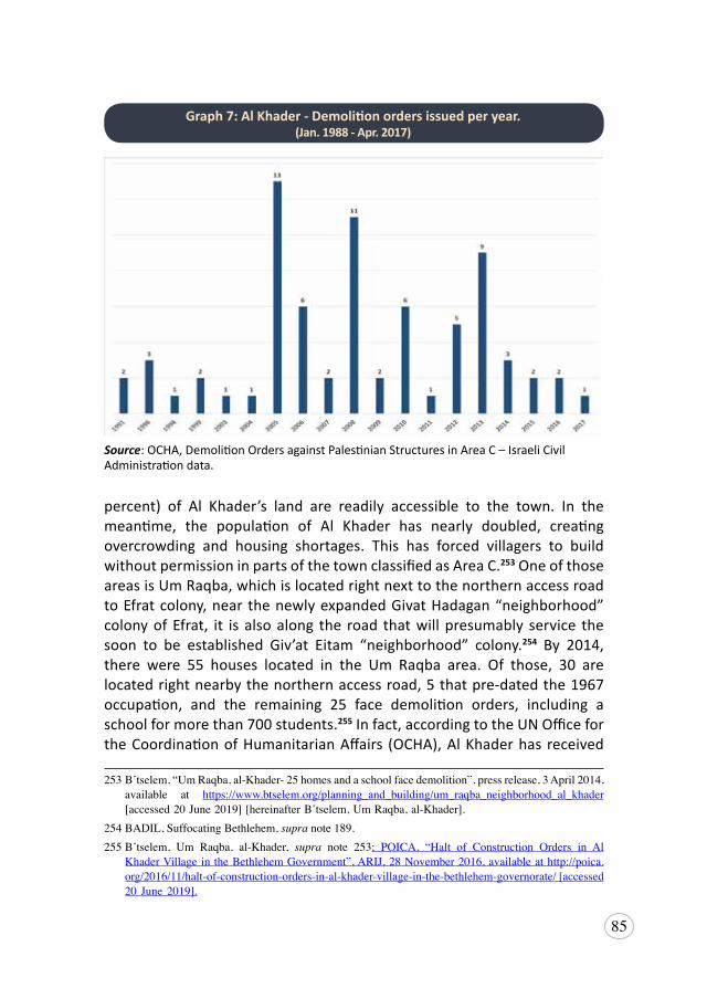
85
percent) of Al Khader’s land are readily accessible to the town. In the meantime, the population of Al Khader has nearly doubled, creating overcrowding and housing shortages. This has forced villagers to build without permission in parts of the town classified as Area C.253 One of those areas is Um Raqba, which is located right next to the northern access road to Efrat colony, near the newly expanded Givat Hadagan “neighborhood” colony of Efrat, it is also along the road that will presumably service the soon to be established Giv’at Eitam “neighborhood” colony.254 By 2014, there were 55 houses located in the Um Raqba area. Of those, 30 are located right nearby the northern access road, 5 that pre-dated the 1967 occupation, and the remaining 25 face demolition orders, including a school for more than 700 students.255 In fact, according to the UN Office for the Coordination of Humanitarian Affairs (OCHA), Al Khader has received
253B’tselem,“UmRaqba,al-Khader-25homesandaschoolfacedemolition”,pressrelease,3April2014,available at https://www.btselem.org/planning_and_building/um_raqba_neighborhood_al_khader [accessed20June2019][hereinafterB’tselem,UmRaqba,al-Khader].
254BADIL,SuffocatingBethlehem,supra note189.255B’tselem, Um Raqba, al-Khader, supra note 253; POICA, “Halt of Construction Orders in Al
KhaderVillageintheBethlehemGovernment”,ARIJ,28November2016,availableathttp://poica.org/2016/11/halt-of-construction-orders-in-al-khader-village-in-the-bethlehem-governorate/[accessed20 June2019].
Graph 7: Al Khader - Demolition orders issued per year. (Jan. 1988 - Apr. 2017)
Source: OCHA, Demolition Orders against Palestinian Structures in Area C – Israeli Civil Administration data.
86
a total of 210 demolition orders up to the year 2017 (see Graph 7), the fourth highest number of any Palestinian village in the West Bank.256 It has also been subjected to the second highest number of demolitions in the Bethlehem Governorate since 2009, with 31 structures demolished, 27 people displaced and another 299 people affected.
Palestinian access to the land on the other side of the Wall is through a single turnstile gate controlled by the Israeli military. Farmers are required to ask permission to bring heavy machinery, such as tractors, to tend their land, and many drivers refuse to come out of fear of attack by Israeli soldiers or colonizers. Without heavy machinery, farmers are dependent on traditional methods to cultivate and harvest their crops, substantially reducing their yield and income. They also regularly face demolition of rudimentary infrastructure built to sustain their agricultural land, due to the lack of permits,257 as well as colonizer attacks on their crops.258 Of those surveyed by BADIL in 2018, almost 48 percent of respondents felt the threat of colonizer attacks; 85 percent described it as either a big threat or very big threat.
“I’mallowedtostay[onmyland]untilthesunset,onSaturdaysif[myfamilyandI]wanttovisitourlandwe’reforcedtobequietandifourchildrenarewithus, they’renotallowed tomakeanynoise.Weare forced toquietourchildrenbecausethecolonizerchildrenareasleep.Thisactuallyhappenedwithus.Theyharassusinallpossibleways,especiallyinthisarea,theytargetit.TheybuiltaWallbetweenusandthem,thentheyinstalledcameras.
Youalsocan’treallyknowjusthowfarthiscolonywillextend.Thenwhenmorecolonizersstartlivinghere,theyaskustoapplyforpermitstoaccessourownland[…]becausethelandistooclosetothem[thecolonizers].[Israel]willalsousetheargumentofthemwantingtoprotectusfromthecolonizerviolencebecausewhenanyonecomesherewithoutarrangingitwithanyone[fromtheIsraeliside],thenanycolonizercanjustshootatyou.
Idon’thaveapermittoaccesstheland.Ihaverefusedthiswholeideafromthebeginning. Iwill not ask Israel anypermission to accessmyown land.
256OCHA,“DemolitionOrdersagainstPalestinianStructures inAreaC– IsraeliCivilAdministrationdata”, 2017, available at https://www.ochaopt.org/page/demolition-orders-against-palestinian-structures-area-c-israeli-civil-administration-data [accessed 20 June 2019].
257POICA, “DemolitionofTwoAgriculturalStructures inAlKhader”,ARIJ, 20 July2012, availableathttp://poica.org/2012/07/demolition-of-two-agricultural-structures-in-al-khader/ [accessed20June2019].
258“Israelrazeslands,uprootsolivetreesinal-Khadervillage”,Ma’an News Agency,12October2018,available at https://www.maannews.com/Content.aspx?id=781421 [accessed 20 June 2019].
87
Anyway, if theyfinishconstructingtheWall,wewill loseour landanyway,becausewedon’thavepermitsandwearebannedforsecurityreasons,eventheelderlyare.Ihaveolivesandgrapeshere.Theolivesneedlesscarethangrapes,whichrequireconstantcare.Thisisabigproblemforus.Atdusk,thesoldierscomeandstandaroundthearea,theydon’tallowustostayafter7pm,otherwisetheycomeandkickusout.
Abu Guevara, Farmer. Interview: Al Khader, 27 July 2017.
Inaddition to thepractical strugglesofday-to-day farming,unable tobuildhousingon their landfor theirchildren, farmerssee theirchildrenforced tomove away. Without new generations coming through, learning the tradeofagriculture, the long-termviabilityandsustainabilityof farming the landbecomesprecarious,andtheabilitytocontinuetoresistIsraeliclaimstotheland increasingly difficult.
I’mafarmerandI’vebeentakingcareofandcultivatingmylandandtryingmybesttokeepitprosperoussince1982.Today,I’m68yearsold.Ihavefivesonsandonedaughter,butonlyoneofmysonsliveswithme.Therestliveoutsidethevillagebecauseoftheirjobs.IhaveenoughspaceforthemheretobuildmorehousesbuttheIsraelioccupationhaspreventedusfrombuildingnewhousesonmyland.MaybewecouldtrytobuildonFridayorSaturdaybutwe’dhavetobesneakyaboutit,withoutthem[Israelis]knowing.Whenevertheyknowaboutanewbuilding,theysendademolitionorder.
Abu Mutaz, retired teacher from Al Khader. Interview: Al Khader, 7 November 2017
As both Abu Guevara and Abu Mutaz alluded to, this is the oppression and obstacles that farmers face. Further, there is little appeal in farming for the younger generations: the challenges are simply too great and the output insufficient. Young people are forced to look elsewhere for their employment.
[…]Israelmadeiteasierforyoungmentotakeworkpermitstoworkin48[inIsrael].Mostofthoseyoungmenusedtobefarmers.Ifyouthinkaboutit,afarmerheredoesn’tbringinenoughincome,ifhehasgrapesaftercultivationandhesellsthosecropshewon’thaveenoughincome.SomostofouryoungmenworkinIsrael.Onlytheeldersstillworktheland.InAlKhader,youwillfindaround20to30oldmen,whoareworkingintheirlands,andtheyonlydoittotakecropstotheirhomesandtomaintaintheland.MostofthelandsinAl
88
Khaderdon’tproduceenough.TherearealsothemanydifficultiesIsraelputsuptodenyfarmersaccesstotheirlands,suchasblockingroadsthatfarmersuseandstoppingfarmersfromtransferringtheircrops.
Abu Guevara, Farmer. Interview: Al Khader, 27 July 2017.
Ominously, statistics suggest that 30 percent of Al Khader’s working population is employed in the Israeli labor market. This statistic must be considered in the context of a country that has the highest rates of unemployment in the world in 2017, according to the International Labour Organization,259 and only a workforce participation rate of 45.4 percent for persons over 15 years old.260 In other words, young Palestinians are forced into situations where they have no option but to take the jobs available in the Israeli market. Moreover, these jobs pay considerably more than the public and private sector in the West Bank, with 247.90 NIS the average daily wage in 2018 for work in Israel or Israel’s colonies, as opposed to 107.90 NIS in the West Bank.261 However, jobs in the Israeli labor market require permits. It has been observed that Israel has increased the issuance of permits to Palestinians in certain areas after significant land confiscation. This may be done in order to divert the attention of the victims of the confiscation and replace agriculture with work in the Israeli labor market. Further, in order to obtain and continue to receive these permits, Palestinians are inherently forced to self-censor their behavior to ensure there is no cause to justify the refusal or cancellation of these permits so critical to their livelihood and survival.
For those who have remained in Al Khader, in recent years, they have increased limitation on their freedom of movement, with the three-year long closure of the main route to Bethlehem.
259InternationalLabourOrganization(ILO),“ILO:UnemploymentintheOccupiedPalestinianTerritoryworld’s highest”, news release, 30May2018, available at https://www.ilo.org/global/about-the-ilo/newsroom/news/WCMS_630876/lang--en/index.html [accessed 20 June 2019].
260Note: theunemployment rateconsidersonly thosewhoareactivelyparticipating in theworkforce,butunabletofindwork.Theoverallunemploymentratewas30.2percentfortheoPt.ThisisskewedbythesituationinGaza,wheretheunemploymentis49.1percent,whiletheWestBanksitsat18.3percent.However, theoPthas anoverallworkforceparticipation rateof just45.5percent, and theparticipationrateintheWestBankandGazaarealmostatparity,with44.9percentand46.2percentrespectively.Assuch,itisundoubtedthattheemploymentsituationinboththeWestBankandtheGazaStripisseriousandoppressive.ForfurtherinformationseePCBS,“TheLabourForceSurveyResultsFourthQuarter (January–March, 2018)”, press release, 2018, available at http://www.pcbs.gov.ps/post.aspx?lang=en&ItemID=3135 [accessed20 June2019].
261PCBS,Press Report on the Labour Force Survey Results (April-June 2018), 7August 2018, 24,available at http://www.pcbs.gov.ps/portals/_pcbs/PressRelease/Press_En_LFSQ22018E.pdf
89
“Israelipoliciesareaffectingourdailylife,suchastheclosureofthemainstreetthatleadstoBethlehem,forcingustoexitanotherway.Whenmychildrenaredelayedfromleavingthevillageontheirwaytowork,theysuffer,especiallyiftherearemilitaryforcesalongtheway.Theforcesmaystopthemandsometimesdetainthem.Thisforcesustostayinthevillageallday[…]
Theclosedstreetaffectsmeeconomically.Ican’tgetatractortoplowmylandbecausethetractordriversareafraidtocomehere.Ifwewanttosendorreceivesomething fromBethlehem,wehave touse thebypass road,but this isveryrisky.TheAlKhaderMunicipalityandtheGovernorofBethlehemhavetriedseveraltimestoopenthegateonthemainstreetbuthaven’tsucceeded[...]AlltheareaherebelongstoAlKhadermunicipality,butitislocatedinAreaC.Theclosurehasalsoaffectededucation,asstudentssufferontheirwaytoschool.Wedon’thaveservices,weareforcedtogetourelectricityfromtheIsraelis[…]
Wetriedtoremovethegatebutsoldierscamethenextdaytoputitupagain.Ifthegatedidn’texist,itwouldmakeourlivessomucheasier:wecoulddriveourcarseasily,thechildrencouldwalkwithoutbeingafraid.Theyputthegateupthreeyearsago,anditstorturingeveryresidentofthevillage.They[Israel]builtitinresponsetothepeopleofAlKhaderresistingtheestablishmentofthesettlements.In theend,weare theoneswhoare suffering: thegate isa formofcollectivepunishment.Theydidn’tevennotifyuswhentheystartedbuildingthegate[…]
Weareafraidaboutoursituation,especiallyoncetheTammarsuburboftheEfratsettlementisfullyinhabitedbysettlers.Wedon’tknowwhattheyaregoingtodotous,maybetheywillannexordeportus[...]Lastyear,asettlerdroveoverandkilledachildfromourvillage.Thegirlwaswalkinginthestreet,andsuddenlythesettlerranherover,Idon’tknowifitwasdeliberateorunintentional.Thatincidentmadeusandherfamilyveryafraid.”
Abu Mutaz, retired teacher from Al Khader. Interview: Al Khader, 7 November 2017
Closure of the main road in Al Khader amounts to a collective punishment imposed on the villagers. This policy results in restrictions on movement and access to services previously sought in Bethlehem city. Collective punishment is also tied to the policy of suppression of resistance, where an entire Palestinian community or village is punished for an action of resisting Israeli colonizers in the surrounding area. Collective punishment is prohibited under international humanitarian law by Article 50 of the Hague Regulations262
262 ICRC,“PracticeRelatingtoRule103.CollectivePunishments”,availableathttps://ihl-databases.icrc.org/customary-ihl/eng/docs/v2_rul_rule103[accessed20June2019].
90
and by the Fourth Geneva Convention,263 as well as under international customary law.264 Yet Israel continues to enact this form of punishment in Al Khader specifically through road closures, which severely affects the daily lives of Palestinians as it inhibits freedom of movement, access to land and resources, economic development and access to health and educational services.
In Al Khader, the combination of Israeli policies including denial of access to services, the permit regime resulting in restrictions of freedom of movement and of the ability to build necessary homes and infrastructures, colonizer violence, and collective punishment or the suppression of resistance, affects the daily lives of the residents, leading to conditions that may result in forcible transfer.
Al Jab’a
Al Jab’a is a Palestinian village with a population of 1,121, located nine kilometers southwest of Jerusalem265 with an 1,800 year history. Its Palestinian population faces the increased risk of forcible displacement through severe isolation, brought about by Israeli measures to annex the area. Located between the Green Line and the colonies of Gvaot and Bat Ayin, Al Jab’a originally fell outside the route of the Apartheid Wall. However, as Route 367 runs through the southern area of Al Jab’a village land and is a key Israeli colonizer road connecting Gush Etzion junction to the other side of the Green Line, the Wall was re-routed to save the expense and inconvenience of constructing a new road for the colonizers.266
Although much of the Wall in this area has yet to be constructed, the village has already had large areas of land confiscated by military order in preparation for the Wall. Additionally, it has long experienced other measures imposed to effectuate the isolation resulting from Israeli annexation. One of the major obstacles residents face are roadblocks and closures that affect their freedom of movement and access to their land, nearby villages, and major centers.
263 GCIV,supra note19,art. 33;AdditionalProtocoltotheGenevaConventionsI(1977),Article75(2)(d);AdditionalProtocoltotheGenevaConventionsII(1977),Article4(2)(b)
264 ICRC, “Rule 103 of Customary IHL”, available at https://ihl-databases.icrc.org/customary-ihl/eng/docs/home [accessed 20 June 2019].
265 PCBS,PopulationEstimates,supra note,209.266POICA,“ThenewchangesontheSegregationWallpathinAlJab’avillage”,ARIJ,16May2006,
available at http://poica.org/2006/05/the-new-changes-on-the-segregation-wall-path-in-al-jaba-village/ [accessed 20 June 2019].
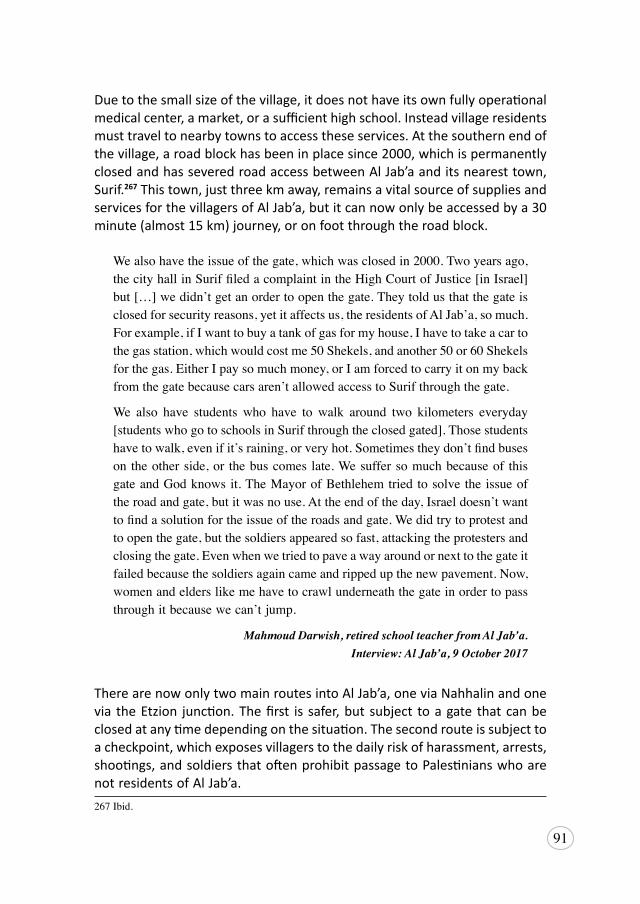
91
Due to the small size of the village, it does not have its own fully operational medical center, a market, or a sufficient high school. Instead village residents must travel to nearby towns to access these services. At the southern end of the village, a road block has been in place since 2000, which is permanently closed and has severed road access between Al Jab’a and its nearest town, Surif.267 This town, just three km away, remains a vital source of supplies and services for the villagers of Al Jab’a, but it can now only be accessed by a 30 minute (almost 15 km) journey, or on foot through the road block.
Wealsohavetheissueofthegate,whichwasclosedin2000.Twoyearsago,thecityhallinSuriffiledacomplaintintheHighCourtofJustice[inIsrael]but[…]wedidn’tgetanordertoopenthegate.Theytoldusthatthegateisclosedforsecurityreasons,yetitaffectsus,theresidentsofAlJab’a,somuch.Forexample,ifIwanttobuyatankofgasformyhouse,Ihavetotakeacartothegasstation,whichwouldcostme50Shekels,andanother50or60Shekelsforthegas.EitherIpaysomuchmoney,orIamforcedtocarryitonmybackfromthegatebecausecarsaren’tallowedaccesstoSurifthroughthegate.
We also have students who have to walk around two kilometers everyday[studentswhogotoschoolsinSurifthroughtheclosedgated].Thosestudentshavetowalk,evenifit’sraining,orveryhot.Sometimestheydon’tfindbuseson theotherside,or thebuscomes late.Wesuffersomuchbecauseof thisgateandGodknowsit.TheMayorofBethlehemtriedtosolvetheissueoftheroadandgate,butitwasnouse.Attheendoftheday,Israeldoesn’twanttofindasolutionfortheissueoftheroadsandgate.Wedidtrytoprotestandtoopenthegate,butthesoldiersappearedsofast,attackingtheprotestersandclosingthegate.Evenwhenwetriedtopaveawayaroundornexttothegateitfailedbecausethesoldiersagaincameandrippedupthenewpavement.Now,womenandelderslikemehavetocrawlunderneaththegateinordertopassthroughitbecausewecan’tjump.
Mahmoud Darwish, retired school teacher from Al Jab’a. Interview: Al Jab’a, 9 October 2017
There are now only two main routes into Al Jab’a, one via Nahhalin and one via the Etzion junction. The first is safer, but subject to a gate that can be closed at any time depending on the situation. The second route is subject to a checkpoint, which exposes villagers to the daily risk of harassment, arrests, shootings, and soldiers that often prohibit passage to Palestinians who are not residents of Al Jab’a. 267Ibid.
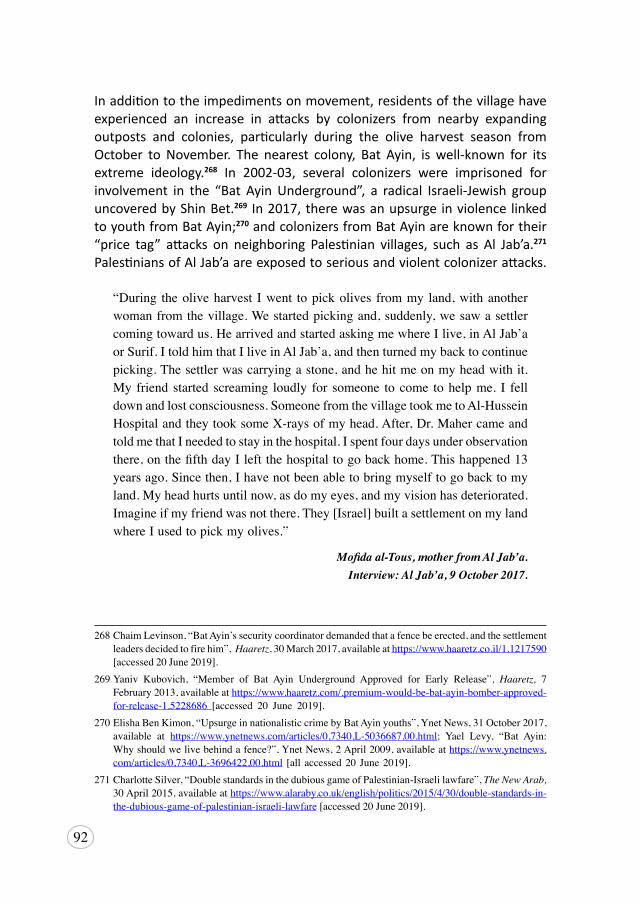
92
In addition to the impediments on movement, residents of the village have experienced an increase in attacks by colonizers from nearby expanding outposts and colonies, particularly during the olive harvest season from October to November. The nearest colony, Bat Ayin, is well-known for its extreme ideology.268 In 2002-03, several colonizers were imprisoned for involvement in the “Bat Ayin Underground”, a radical Israeli-Jewish group uncovered by Shin Bet.269 In 2017, there was an upsurge in violence linked to youth from Bat Ayin;270 and colonizers from Bat Ayin are known for their “price tag” attacks on neighboring Palestinian villages, such as Al Jab’a.271 Palestinians of Al Jab’a are exposed to serious and violent colonizer attacks.
“During theoliveharvest Iwent topickolives frommy land,withanotherwomanfromthevillage.Westartedpickingand,suddenly,wesawasettlercomingtowardus.HearrivedandstartedaskingmewhereIlive,inAlJab’aorSurif.ItoldhimthatIliveinAlJab’a,andthenturnedmybacktocontinuepicking.Thesettlerwascarryingastone,andhehitmeonmyheadwithit.My friend started screaming loudly for someone to come tohelpme. I felldownandlostconsciousness.SomeonefromthevillagetookmetoAl-HusseinHospitalandtheytooksomeX-raysofmyhead.After,Dr.MahercameandtoldmethatIneededtostayinthehospital.Ispentfourdaysunderobservationthere,onthefifthdayIleftthehospitaltogobackhome.Thishappened13yearsago.Sincethen,Ihavenotbeenabletobringmyselftogobacktomyland.Myheadhurtsuntilnow,asdomyeyes,andmyvisionhasdeteriorated.Imagineifmyfriendwasnotthere.They[Israel]builtasettlementonmylandwhereIusedtopickmyolives.”
Mofida al-Tous, mother from Al Jab’a. Interview: Al Jab’a, 9 October 2017.
268ChaimLevinson,“BatAyin’ssecuritycoordinatordemandedthatafencebeerected,andthesettlementleadersdecidedtofirehim”,Haaretz,30March2017,availableathttps://www.haaretz.co.il/1.1217590 [accessed20June2019].
269Yaniv Kubovich, “Member of Bat Ayin Underground Approved for Early Release”, Haaretz, 7 February2013,availableathttps://www.haaretz.com/.premium-would-be-bat-ayin-bomber-approved-for-release-1.5228686 [accessed 20 June 2019].
270ElishaBenKimon,“UpsurgeinnationalisticcrimebyBatAyinyouths”,YnetNews,31October2017,available at https://www.ynetnews.com/articles/0,7340,L-5036687,00.html; Yael Levy, “Bat Ayin:Whyshouldwelivebehindafence?”,YnetNews,2April2009,availableathttps://www.ynetnews.com/articles/0,7340,L-3696422,00.html [allaccessed20June2019].
271CharlotteSilver,“DoublestandardsinthedubiousgameofPalestinian-Israelilawfare”,The New Arab, 30April2015,availableathttps://www.alaraby.co.uk/english/politics/2015/4/30/double-standards-in-the-dubious-game-of-palestinian-israeli-lawfare[accessed20June2019].
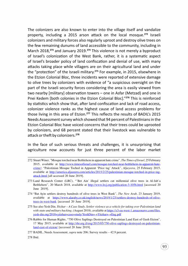
93
The colonizers are also known to enter into the village itself and vandalize property, including a 2015 arson attack on the local mosque.272 Israeli colonizers and military forces also regularly uproot and destroy olive trees on the few remaining dunums of land accessible to the community, including in March 2018,273 and January 2019.274 This violence is not merely a byproduct of Israel’s colonization of the West Bank, rather, it is a systematic aspect of Israel’s broader policy of land confiscation and denial of use, with many attacks taking place while villagers are on their agricultural land and under the “protection” of the Israeli military.275 For example, in 2015, elsewhere in the Etzion Colonial Bloc, three incidents were reported of extensive damage to olive trees by colonizers with evidence of “a suspicious oversight on the part of the Israeli security forces considering the area is easily viewed from two nearby [military] observation towers – one in Asfar (Metzad) and one in Pnei Kedem [both colonies in the Etzion Colonial Bloc].”276 This is reinforced by statistics which show that, after land confiscation and lack of road access, colonizer violence ranks as the highest cause of land access problems for those living in this area of Etzion.277 This reflects the results of BADIL’s 2015 Needs Assessment survey which showed that 94 percent of Palestinians in the Etzion Colonial Bloc have voiced concerns that their trees could be uprooted by colonizers, and 68 percent stated that their livestock was vulnerable to attack or theft by colonizers.278
In the face of such serious threats and challenges, it is unsurprising that agriculture now accounts for just three percent of the labor market
272StuartWiner,”MosquetorchednearBethleheminapparenthatecrime”,The Times of Israel, 25February2015, available at http://www.timesofisrael.com/mosque-torched-near-bethlehem-in-apparent-hate-crime/; “PalestinianMosqueToched inApparent ‘Price tag’Attack”,Aljazeera, 25February2015,available at http://america.aljazeera.com/articles/2015/2/25/palestinian-mosque-torched-in-price-tag-attack.html[allaccessed20June2019].
273Land Research Center (LRC), “’Bet Ain’ illegal settlers cut millennial olive trees in Al-Jab’aBethlehem”, 20March 2018, available at http://www.lrcj.org/publication-3-1056.html [accessed 20June 2019].
274“BatAyinsettlersdestroyhundredsofolive trees inWestBank”,The New Arab, 23January2019,available at https://www.alaraby.co.uk/english/news/2019/1/23/settlers-destroy-hundreds-of-olive-trees-in-west-bank [accessed 20 June 2019].
275SeealsoYeshDin, Yitzhar – A Case Study. Settler violence as a vehicle for taking over Palestinian land with state and military backing,(August2018),availableathttps://s3-eu-west-1.amazonaws.com/files.yesh-din.org/2018+yitzhar+case+study/YeshDin+-+Yitzhar+-+Eng.pdf
276 RabbisforHumanRights,“750OliveSaplingsDestroyedonPalestinianLandEastofGushEtzion”,17 May2015, available at http://rhr.org.il/eng/2015/05/750-olive-saplings-destroyed-on-palestinian-land-east-of-etzion/[accessed20June2019].
277BADIL,NeedsAssessment,supra note206;Surveyresults–42.9percent.278 Ibid.
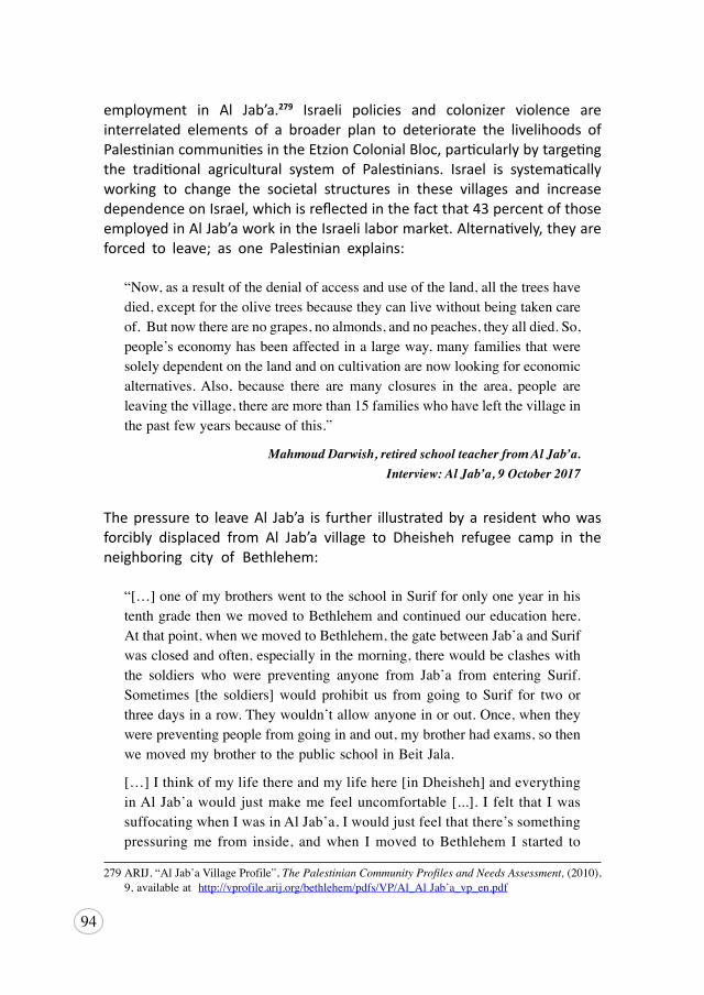
94
employment in Al Jab’a.279 Israeli policies and colonizer violence are interrelated elements of a broader plan to deteriorate the livelihoods of Palestinian communities in the Etzion Colonial Bloc, particularly by targeting the traditional agricultural system of Palestinians. Israel is systematically working to change the societal structures in these villages and increase dependence on Israel, which is reflected in the fact that 43 percent of those employed in Al Jab’a work in the Israeli labor market. Alternatively, they are forced to leave; as one Palestinian explains:
“Now,asaresultofthedenialofaccessanduseoftheland,allthetreeshavedied,exceptfortheolivetreesbecausetheycanlivewithoutbeingtakencareof.Butnowtherearenograpes,noalmonds,andnopeaches,theyalldied.So,people’seconomyhasbeenaffectedinalargeway,manyfamiliesthatweresolelydependentonthelandandoncultivationarenowlookingforeconomicalternatives.Also, because there aremany closures in the area, people areleavingthevillage,therearemorethan15familieswhohaveleftthevillageinthepastfewyearsbecauseofthis.”
Mahmoud Darwish, retired school teacher from Al Jab’a. Interview: Al Jab’a, 9 October 2017
The pressure to leave Al Jab’a is further illustrated by a resident who was forcibly displaced from Al Jab’a village to Dheisheh refugee camp in the neighboring city of Bethlehem:
“[…]oneofmybrotherswenttotheschoolinSurifforonlyoneyearinhistenthgradethenwemovedtoBethlehemandcontinuedoureducationhere.Atthatpoint,whenwemovedtoBethlehem,thegatebetweenJab’aandSurifwasclosedandoften,especiallyinthemorning,therewouldbeclasheswiththe soldiers who were preventing anyone from Jab’a from entering Surif.Sometimes [the soldiers]would prohibit us from going to Surif for two orthreedaysinarow.Theywouldn’tallowanyoneinorout.Once,whentheywerepreventingpeoplefromgoinginandout,mybrotherhadexams,sothenwemovedmybrothertothepublicschoolinBeitJala.
[…]Ithinkofmylifethereandmylifehere[inDheisheh]andeverythinginAlJab’awouldjustmakemefeeluncomfortable[...]. I felt thatIwassuffocatingwhenIwasinAlJab’a,Iwouldjustfeelthatthere’ssomethingpressuringme from inside, andwhen Imoved toBethlehem I started to
279ARIJ,“AlJab’aVillageProfile”,The Palestinian Community Profiles and Needs Assessment, (2010),9,availableat http://vprofile.arij.org/bethlehem/pdfs/VP/Al_AlJab’a_vp_en.pdf
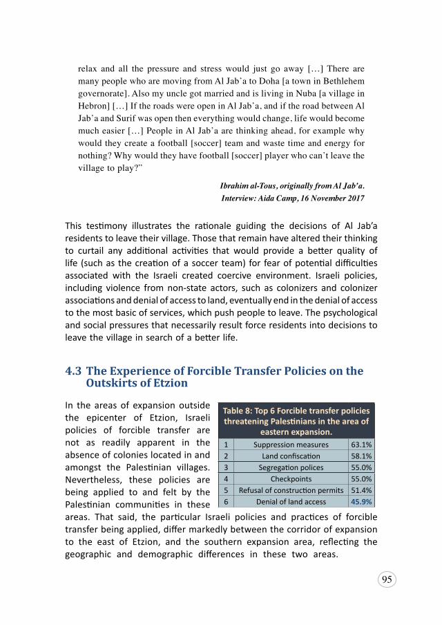
95
relax and all the pressure and stresswould just go away […]There aremanypeoplewhoaremovingfromAlJab’atoDoha[atowninBethlehemgovernorate].AlsomyunclegotmarriedandislivinginNuba[avillageinHebron][…]IftheroadswereopeninAlJab’a,andiftheroadbetweenAlJab’aandSurifwasopentheneverythingwouldchange,lifewouldbecomemucheasier[…]PeopleinAlJab’aarethinkingahead,forexamplewhywouldtheycreateafootball[soccer]teamandwastetimeandenergyfornothing?Whywouldtheyhavefootball[soccer]playerwhocan’tleavethevillagetoplay?”
Ibrahim al-Tous, originally from Al Jab’a. Interview: Aida Camp, 16 November 2017
This testimony illustrates the rationale guiding the decisions of Al Jab’a residents to leave their village. Those that remain have altered their thinking to curtail any additional activities that would provide a better quality of life (such as the creation of a soccer team) for fear of potential difficulties associated with the Israeli created coercive environment. Israeli policies, including violence from non-state actors, such as colonizers and colonizer associations and denial of access to land, eventually end in the denial of access to the most basic of services, which push people to leave. The psychological and social pressures that necessarily result force residents into decisions to leave the village in search of a better life.
4.3 The Experience of Forcible Transfer Policies on the Outskirts of Etzion
In the areas of expansion outside the epicenter of Etzion, Israeli policies of forcible transfer are not as readily apparent in the absence of colonies located in and amongst the Palestinian villages. Nevertheless, these policies are being applied to and felt by the Palestinian communities in these areas. That said, the particular Israeli policies and practices of forcible transfer being applied, differ markedly between the corridor of expansion to the east of Etzion, and the southern expansion area, reflecting the geographic and demographic differences in these two areas.
Table 8: Top 6 Forcible transfer policies threatening Palestinians in the area of
eastern expansion.1 Suppression measures 63.1%2 Land confiscation 58.1%3 Segregation polices 55.0%4 Checkpoints 55.0%5 Refusal of construction permits 51.4%6 Denial of land access 45.9%
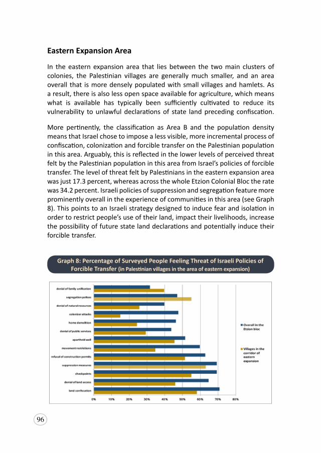
96
Eastern Expansion Area
In the eastern expansion area that lies between the two main clusters of colonies, the Palestinian villages are generally much smaller, and an area overall that is more densely populated with small villages and hamlets. As a result, there is also less open space available for agriculture, which means what is available has typically been sufficiently cultivated to reduce its vulnerability to unlawful declarations of state land preceding confiscation.
More pertinently, the classification as Area B and the population density means that Israel chose to impose a less visible, more incremental process of confiscation, colonization and forcible transfer on the Palestinian population in this area. Arguably, this is reflected in the lower levels of perceived threat felt by the Palestinian population in this area from Israel’s policies of forcible transfer. The level of threat felt by Palestinians in the eastern expansion area was just 17.3 percent, whereas across the whole Etzion Colonial Bloc the rate was 34.2 percent. Israeli policies of suppression and segregation feature more prominently overall in the experience of communities in this area (see Graph 8). This points to an Israeli strategy designed to induce fear and isolation in order to restrict people’s use of their land, impact their livelihoods, increase the possibility of future state land declarations and potentially induce their forcible transfer.
Graph 8: Percentage of Surveyed People Feeling Threat of Israeli Policies of Forcible Transfer (in Palestinian villages in the area of eastern expansion)
97
Interestingly, the threat of land confiscation remains a policy felt prominently by these communities, with almost 60 percent reporting a big threat, and almost ten percent feeling a very big threat from the risk of land confiscation. This suggests that these communities recognize the likelihood of land confiscation given its proximity to the epicenter of Etzion Colonial Bloc, where the policy has been devastating on livelihoods. These communities made 227 complaints about land confiscations and those complaints resulted in a 50 percent lower reported rate of success than other areas.280 This, combined with the threat of confiscation felt, indicates that despite the significant Area B designations, which are theoretically under partial-Palestinian control, Israel is still targeting the neighboring land categorized as Area C. In particular, the two corridors of land zoned as Area C that connect Efrat to the eastern colonies of Tekoa, Nokdim, Ma’ale Amos and Asfar. To that end, evidence of this intent is reflected in both the colonial policies of Israel, discussed above in Sub-Section 3.3: Entrenchment and Consolidation of the Etzion Colonial Bloc, particularly the commandeering of a local road for colonizers and the plans with Givat Eitam, as well as in the reported experience of Palestinian villagers.
In addition, people in this area experience the lack of services as they become more isolated from Bethlehem, due to the construction and continuous expansion of Efrat colony. There is no ready access to Route 60, the main road into Bethlehem, and Palestinians are either potentially exposed to colonizer violence and checkpoints, or must take the longer, slower winding village route into Bethlehem, where exposure to Israeli colonizers from the eastern bloc is also a risk. As a result, these villages suffer from a lack of access to health care, higher education, and recreation centers, and also the social and economic segregation and isolation that results from restrictions on movement and access. Moreover, these communities already suffer from the lack of effective complaint mechanisms to redress existing issues concerned with service provision. Just 32 percent of 1009 reported complaints were effectively resolved by the entity to which Palestinians submitted complaints to (see Table 7). Only eight of those complaints were handled by iNGOs and 29 made to local NGOs. These communities felt more confident in dealing with the coercive environment locally, particularly within their own community, more so than other Palestinian areas in the Etzion bloc. Based on the experience in the epicenter of the bloc, as Israeli policies of segregation
280BADIL’sNeedsAssessmentsurveyresultsshowthatjust12percentofreportedcomplaintsaboutlandconfiscationfromthesevillageswereeffective.Villagesintheepicentrereportedthatof265complaints,24percentwereeffective,andinthesoutherntownsitwasreportedthatof1027complaints,28percentwereconsideredeffectivelyresolved.See:BADIL,NeedsAssessment,supra note206.
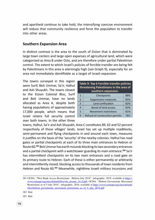
98
and apartheid continue to take hold, the intensifying coercive environment will reduce that community resilience and force the population to transfer into other areas.
Southern Expansion Area
In distinct contrast is the area to the south of Etzion that is dominated by large town centers and large open expanses of agricultural land, which were categorized as Area B under Oslo, and are therefore under partial Palestinian control. The extent to which Israel’s policies of forcible transfer are being felt by Palestinians in this area is alarmingly high (see Graph 9), especially for an area not immediately identifiable as a target of Israeli expansion.
The towns surveyed in this region were Surif, Beit Ummar, Sa’ir, Halhul and Ash Shuyukh. The towns closest to the Etzion Colonial Bloc, Surif and Beit Ummar, have no lands allocated as Area A, despite both having populations of approximately 17,000 people, which means that Israel retains full security control over both towns. In the other three towns, Halhul, Sa’ir and Ash Shuyukh, Area C constitutes 89, 62 and 52 percent respectively of these villages’ lands. Israel has set up multiple roadblocks, semi-permanent and flying checkpoints in and around each town, measures it justifies on the basis of the ‘security’ of the nearby colonies. Halhul has road gates or partial checkpoints at each of its three main entrances to Hebron or Route 60.281 Beit Ummar has earth mounds blocking its two secondary entrances and a partial checkpoint with a watchtower guarding its main entrance.282 Sa’ir has intermittent checkpoints on its two main entrances and a road gate on its primary route to Hebron. Each of these is either permanently or arbitrarily and intermittently closed, blocking access to thousands of town residents from Hebron and Route 60.283 Meanwhile, nighttime Israeli military incursions and
281OCHA,“WestBankAccessRestrictions-HebronJuly2018”,infographic,2018,availableathttps://www.ochaopt.org/sites/default/files/wb_closure_14_0.pdf;OCHA,“HebronGovernorateMovementRestrictionsasof5July2016”,infographic,2016,availableathttps://www.ochaopt.org/sites/default/files/hebron_governorate_movement_restrictions_as_of_5_july_2016.pdf
282Ibid.283Ibid.
Table 9: Top 6 Forcible transfer policies threatening Palestinians in the area of
southern expansion.1 Checkpoints 88%2 Suppression measures 85%3 Land confiscation 82%4 denial of land access 82%5 Movement restrictions 81%6 Refusal of construction permits 78%
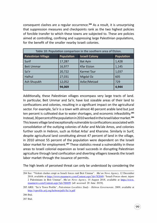
99
consequent clashes are a regular occurrence.284 As a result, it is unsurprising that suppression measures and checkpoints rank as the two highest policies of forcible transfer to which these towns are subjected to. These are policies aimed at controlling, confining and suppressing large Palestinian populations, for the benefit of the smaller nearby Israeli colonies.
Table 10: Population comparison in the southern area of Etzion.Palestinian Village Population Israeli Colony PopulationSurif 17,287 Bat Ayin 1,428Beit Ummar 16,977 Kfar Etzion 1,145 Sa’ir 20,722 Karmei Tzur 1,037Halhul 27,031 Migdal Oz 605Ash Shuyukh 12,052 Asfar/Metzad 729
94,069 4,944
Additionally, these Palestinian villages encompass very large tracts of land. In particular, Beit Ummar and Sa’ir, have lost sizeable areas of their land to confiscations and colonies, resulting in a significant impact on the agricultural sector. For example, Sa’ir is a town with almost 40 percent arable land but just ten percent is cultivated due to water shortages, and economic infeasibility.285 Instead, 30 percent of the population in 2010 worked in the Israeli labor market.286 This leaves village land exceptionally vulnerable to confiscations associated with consolidation of the outlying colonies of Asfar and Ma’ale Amos, and colonies further south in Hebron, such as Kirbat Arba’ and Kharsine. Similarly in Surif, despite agricultural land constituting almost 47 percent of land in the village, in 2010 almost 55 percent of the population were dependent on the Israeli labor market for employment.287 These statistics reveal a vulnerability in these areas to Israeli colonial expansion as Israel succeeds in disrupting Palestinian agriculture through land confiscation and diverting villagers towards the Israeli labor market through the issuance of permits.
The high levels of perceived threat can only be understood by considering the
284See:“ViolentclasheseruptasIsraeliforcesraidBeitUmmar”,Ma’an News Agency, 12December2018,availableat https://www.maannews.com/Content.aspx?id=782049;“IsraeliForcesshoot,injure2 Palestinians in Beit Ummar”,Ma’an News Agency, 14August 2018, available at https://www.maannews.com/Content.aspx?id=780699 [all accessed 20 June 2019].
285ARIJ,“Sa’irTownProfile”,Palestinian Localities Study - Hebron Governorate,2009,availableathttp://vprofile.arij.org/hebron/pdfs/Sa’ir.pdf
286Ibid.287Ibid.
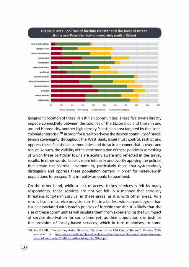
100
geographic location of these Palestinian communities. These five towns directly impede connectivity between the colonies of the Etzion bloc and those in and around Hebron city, another high density Palestinian area targeted by the Israeli colonial enterprise.288 In order for Israel to achieve the desired continuity of Israeli-Jewish sovereignty throughout the West Bank, Israel must control, restrict and oppress these Palestinian communities and do so in a manner that is overt and robust. As such, the visibility of the implementation of these policies is something of which these particular towns are acutely aware and reflected in the survey results. In other words, Israel is more intensely and overtly applying the policies that create the coercive environment, particularly those that systematically distinguish and oppress these population centers in order for Israeli-Jewish populations to prosper. This in reality amounts to apartheid.
On the other hand, while a lack of access to key services is felt by many respondents, these services are not yet felt in a manner that seriously threatens long-term survival in these areas, as it is with other areas. As a result, issues of service provision are felt to a far less widespread degree than issues associated with Israel’s policies of forcible transfer. It is likely that the size of these communities will insulate them from experiencing the full impact of service deprivation for some time yet, as their population size justifies the provision of locally-based services, which in turn minimises, to some
288See BADIL, “Forced Population Transfer: The Case of the Old City of Hebron”, October 2016,available at https://www.badil.org/phocadownloadpap/badil-new/publications/research/working-papers/CaseStudyFPT-Hebron-Brief-Eng(Oct2016).pdf
Graph 9: Israeli policies of forcible transfer and the level of threat. (in the rural Palestinian towns immediately south of Etzion)
101
extent, the effect of other policies of forcible transfer such as restrictions on movement and segregation. Moreover, their population size and location in Area B, in principle, gives the PA greater access to provide at least a basic level of many services. However, the high number of complaints being made and the already poor levels of complaint effectiveness (just 31 percent overall) are especially concerning and indicative of future deterioration as people cease agitating for better service provision in the face of non-responsiveness.
Wadi Rahhal
Wadi Rahhal is a Palestinian village 5.7 kilometers south of Bethlehem, with a population of 1,819.289 It consists of four hamlets that sit on the hilltops of the valley. Wadi Rahhal is located on the eastern boundary of Efrat, one of the largest and most rapidly expanding colonies in the West Bank. The village is also facing the prospect of segregation from Bethlehem, when the new colony of Givat Eitam, with at least 2,500 housing units, is constructed on the hill immediately to its north, on the land of Khallet an-Nahla, a hamlet of Wadi Rahhal village. With more than sixty percent of the land in Wadi Rahhal designated as Area C, almost all of which is open agricultural land controlled by Israel, it leaves the village extremely vulnerable to Israel’s colonial practices and policies of forcible population transfer.
The designation of the agricultural land as Area C is consistent with the situation in other Palestinian villages exposed to the Etzion Colonial Bloc, and makes Wadi Rahhal vulnerable in two respects. First, as evidenced by the land confiscation practices exhibited in other villages, open agricultural land is at a high risk of confiscation and is undoubtedly earmarked for expansion of the Efrat colony. Indicative of this assessment is the sizeable land confiscation (December 2018) for the Givat Eitam colonial project, as well as in the smaller confiscations that have happened in the last seven years, including 14 dunums in 2011,290 seven dunums in 2014,291 and 30 dunums in 2015.292
289 PCBS,PopulationEstimates,supra note209. 290POICA, “The Confiscation of Umm Salamona,Wad Rahhal andWadi al Nis Lands- Bethlehem
Governorate”, ARIJ, 30 December 2011, available at http://poica.org/2011/12/the-confiscation-of-umm-salamona-wad-rahhal-and-wadi-al-nis-lands-bethlehem-governorate/ [accessed 20 June 2019].
291POICA,“TheIsraelioccupationnotifies7agriculturaldunumswithevictioninthevillageofWadiRahhal”,ARIJ,29April2014,availableathttp://poica.org/2014/04/the-israeli-occupation-notifies-7-agricultural-dunums-with-evection-in-the-village-of-wadi-rahhal/ [accessed 20 June 2019].
292POICA,“Ravagingof30dunumsfromtheBethlehemvillageofWadRahhal”,ARIJ,14January2015,availableathttp://poica.org/2015/01/ravaging-30-dunums-from-the-bethlehem-village-of-wad-rahhal/ [accessed20June2019].
102
Second, more than half the workforce in the village is employed in agriculture, which means the substantial majority of the villagers are dependent on agriculture for their livelihoods. As Israel slowly seizes land and implements its policies, which deter people from engaging in agriculture, the intent is to force abandonment of the sector and further expose their land to risk of confiscation through non-cultivation. The construction of the Apartheid Wall isolated 144 dunums of Wadi Rahhal from the rest of the village, further deteriorating the village’s agricultural sector. Although the Wall is not fully constructed, the land has been demarcated and is off limits to its Palestinians owners. In 2014, the Israeli military closed an agricultural road linking Wadi Rahhal and the neighboring village of Artas.293 Two years later, the Israeli military razed and uprooted 130 olive seedlings in Wadi Rahhal.294 Then in 2018, the colonizers from Efrat built their own road to connect Efrat with the outpost on Khallet an-Nahla land, where Givat Eitam will be.295 While the reported incidents do not appear to be as intense or as frequent as reported by villages in the epicenter of Etzion, these policies are nonetheless having a chilling effect on livelihoods in the village. It is notable that by 2010, already seven percent of the population was employed in the Israeli labor market,296 and anecdotally this has substantially increased. Moreover, the detriment to the agricultural sector is compounded by other policies.
OurwaterpipescomefromEfratcolony.Thiswaterinfrastructurewasverypooruntil twomonthsago,when thenew localcouncilchairman,whohadbeeninchargeofthevillage’swaterpipelineprojectfornearlyfivemonths,completed a new project renovating the water networks. Despite this, thewaterpressureisofteninsufficientbecausethecolonyhasthisstrategyofonlyopeningthewatervalvetoaquarterflow[…]WealsosufferduetothewaterwastageandexcessusebytheIsraelis,andthatisthereasonwhywedonotgetwater.
[…]Wehavebeensufferingfromthiswaterscarcityproblemfornearlytenyears.WhenyoupassbytheEfratcolony,youcanseethegreeneryandrosesallalongtheway.Andwejustdreamofasproutofmintgrowing.Imaginethat
293 ARIJ,“IsraelViolations’ActivitiesintheoPt”,newsrelease,2June2014,3,availableathttp://poica.org/upload/Image/daily_report_2014_images/June per cent202014/june0214.pdf
294 ARIJ, “Israeli Violations’ Activities in the oPt”, news release, 10 August 2016, 2, available at http://www.poica.org/upload/Image/Daily per cent20Reports per cent202016/Aug per cent202016/august1016.pdf
295LRC, “Opening a colonial road in Wadi Rahhal/ Bethlehem governorate“, 17 September 2018,available at http://www.lrcj.org/publication-3-1132.html [accessed 20 June 2019].
296ARIJ, “WadiRahhalVillageProfile”,The Palestinian Community Profiles and Needs Assessment, (2010), available at http://vprofile.arij.org/bethlehem/pdfs/VP/Wadi%20Rahhal_vp_en.pdf
103
becauseofthislackofwaterifsomeonefromthevillagedies,webathehiminthehospital,andweopenthe“consolationhouse”inDohaoranywhereelsewherepeoplecanaccesswatereasilyformakingcoffee,drinkingorwashing.
[…] If thewomen in the village,who have a garden, could grow spinach,peppers,onion,tomato,cauliflowerandlettuce,theywouldn’tneedtotravelanhourbyroadintothecitytobuyalltheirneeds.But,unfortunately,wecan’tgrowsomuchasastickofmint;anythingthatweplantjustdiesduetothelackofwater.
Besides this, there is no longer so much cultivation of the land becausePalestinians farmers now work in the colony, so our land has to someextentbeenabandoned.WeusedtobethebreadbasketforthewholeareaofBethlehem, now we are only consumers.
Yusra Abu A’hour, resident of a-Thubra (Wadi Rahhal), member of the Women’s Committee.
Interview: a-Thubra, 11 October 2017
Water is a fundamental building block for life and for civilization, and as such is critical to the realization of numerous basic human rights, including the right to life, an adequate standard of living, adequate food and health. The UN Committee on Economic, Social and Cultural Rights, in General Comment 15, recognized the fundamental legal basis for the right to water in international law, and noted it is a right that contains both freedoms and entitlements.297 Namely, it includes the freedom to maintain access and freedom from interference, as well as the right to be free from arbitrary disconnections and contamination of the water supply. This sits alongside the entitlement to “a system of water supply and management that provides equality of opportunity for people to enjoy the right to water.”298 Israel systematically denies Palestinians the right to water, by unlawfully denying Palestinians the right to control their own water resources, and by administering a discriminatory system of water supply that grossly undersupplies Palestinian communities, to the benefit of nearby Israeli colonies.299 Across the oPt, Palestinians consume on average just 70 liters per day, only borderline meeting the 50-100 liters per day recommended
297Comm.onEconomic,SocialandCulturalRights,SubstantiveIssuesArisingintheImplementationoftheInternationalCovenantonEconomic,SocialandCulturalRights:GeneralCommentNo.15,U.N.Doc. E/C.12/2002/11 (2002), available at http://www1.umn.edu/humanrts/gencomm/escgencom15.htm[accessed20June2019].
298Ibid.299See:AmnestyInternational,TroubledWaters,supra note226.
104
by the WHO to meet basic necessities, but in many villages this drops to 20 liters per day, the emergency level. Meanwhile, colonizers in the West Bank consume on average 300 liters per capita per day, allowing for irrigation intensive agriculture, garden beds and swimming pools.300
The Israeli policy of segregation is felt particularly strongly in the villages of this area, like Wadi Rahhal, more so than in other areas affected by the Etzion Colonial Bloc. The existence of the long, meandering colony of Efrat, and its ongoing expansion has severed these communities from the main thoroughfare through the West Bank, Route 60, and quick access into Bethlehem. Additionally, the colony has a large security apparatus to guard it, and its presence is felt acutely in the village. As a result, access and transportation are particularly significant concerns for villagers, because of a lack of services and prohibitive cost, that then result in the denial of access to vital basic services and exacerbating the sense of isolation and segregation.
“Wesuffersomuchbecauseoftransportation;weareforcedtowalkalongdistance(onekilometer) to reach themainstreet.Mysonsandhusbandaresickandtheyneedtoseeadoctorconstantly.EveryfewdaysItakethemtothedoctor,soI’mforcedtocallacar[…]andpaytenshekelseachtime.Iamnotabletopayallofthismoneytwiceaday.IfIwanttogowithmysonsitwouldcostmearoundfiftyshekels.SometimesIjustcan’ttakethemtothedoctor […]
Sometimes,thesoldierscometothevillageandpreventusfromentering[…]TheotherdayIhadtowalkpastthesoldiers,onthesideoftheroad,becausethedriverrefusedtogivemearideallthewaytoan-Nahla.Hetoldmehecan’tbecausethereweresoldiersthere.SoIhadtocarrymysonandmybelongingsandwalktoan-Nahla.Despitethefactthattheotherpassengerscomplainedtothedriverandaskedhimtogivemearide,hestillrefusedtodosobecauseofthesoldiers.HeleftmeonthestreetandIhadtowalkallthewaytomyhome[…]
TheothernightmyhusbandgotreallysickduringthenightandIcouldn’ttakehimtothehospital.Icouldn’tleavemyyoungchildrenhomealoneandgotothehospital,whileourhomewassurroundedbysoldiers.ItoldmyhusbandIcan’triskleavingmychildrenaloneinthehouse,soIjustgavehimpainkillers.Afterafewhourshestartedfeelingthepainagain,butIjustcouldn’ttakehim.Itwouldcostusmorethana100Shekelsifacaragreedtotakeusinthefirstplace[…]
300Id.,4-5.
105
Mysonswalkalongdistance[twokilometers]froman-Nahla.SometimesIdon’tsendMohammadtoschoolbecauseof theprobleminhismuscles,hecan’twalk.[…]Idon’thavemoneytopayacartodrivemysonstoschool.Somysonshavetowalk:theywalkinthewinterandtheyalsowalkwhentheweatherisreallyhot[…]MysonMohammadoncehadfever,histemperaturewasreallyhighandtherewerenocarsatall,notransportation.Ihadtowaituntilthenextdaytotakehimtothehospital.Nowhehasahearingproblem,hecanonlyhearinoneear.Thisisbecauseofthefever,andbecausetherewerenocarstotakehimtoadoctorthatday.”
Amena Fawaghra, mother from Wadi Rahhal. Interview: Wadi Rahhal, 9 November 2017
It is evident from this testimony that issue with transportation is not just having access to it, but the prohibitively high cost. The village has virtually no access to public transport, and as a result is dependent on cost-prohibitive private taxis or privately owned vehicles within the village. This situation is compounded by the deteriorating economic situation in the village, in part due to the assault on village agriculture, and culminates in a situation impacting Palestinians’ ability to access essential services like education and health care.
[…]We have to pay extra for transportation and extra for water, I mean,peoplecan’thandleallofthiseconomicpressure.We’remostlypoorpeopleinthevillage,myhusbandworkstoprovideforsevenoreightmembersinourhousehold.ThankGodnoneofmychildrengotouniversity,Icouldn’taffordto provide for their education because we’re too poor. Our children aren’tstupid,theyusedtoget72and67,thesedayseventhestudentwhoscores52cancontinuehiseducationifhehasmoney.
Mydaughter,Hanaa,droppedoutofschoolbecauseitwastoofarfromhome.TheotherdayshewasaskingmewhetherIwantedhertofinishherTawjihi[finalexaminations forhighschooldiploma]ornot,Sheansweredherownquestionsaying“wherewouldIgotoschool?I’mnotgoinganywhereoutofThabra,soIdon’twantmyTawjehi.”Itriedtoconvincehertogotoschool,but itwasuseless.She’shomenowanddidn’tfinishhereducationandshekeepstellingme:“Idon’tregretnotfinishingschool,I’mnotgoinganywherethesoldierscanshootme.”
[…]Anotherimpactthatwesufferedfromwasthefearforourchildrenandyouth toevengo to theschoolbecauseof thecolonizers.Before,wedidn’t

106
haveaschool,soourchildrenusedtogotoAlKhaderschoolorAlMasaraschool,resultinginalargenumberdroppingoutofschoolamongtheyouth.Wealsofeartorunintothecolonizers,soweavoidgoingoutatnightandwecancelmanyofourtripssowestayawayfromthem.Theyalsocontrolthewaywecelebrateourweddings,forexampletheyforbidusfromusingfireworks[thatareoftenapartofPalestinianweddings].
Yusra Abu A’hour, resident of a-Thubra (Wadi Rahhal), member of the Women’s Committee.
Interview: a-Thubra, 11 October 2017
Although the village has addressed the issue of school dropouts by building a school within the village, this has the effect of creating further segregation and isolation within the community. The above testimonies vividly illustrate how Israel’s restrictions on movement, as well as the presence of the colony and its colonizers have a direct human impact on Wadi Rahhal. Due to intensified Israeli presence and checkpoints in the Palestinian areas surrounded by the colonies, experiences like those described above are not uncommon. It is estimated that over 20 percent of Palestinian communities in Area C have extremely restricted access to health services, as all advanced Palestinian medical service facilities and providers are located in areas A and B, and they do not have access to Israeli medical facilities in Area C.301 Therefore, people, like Amena and her family, are required to travel distances, encounter checkpoints and roadblocks, and are exposed to the Israeli military or colonizers en route, whether by car or by foot, if they want to seek essential services such as health care. When the pressure imposed on residents by Israeli policies such as the denial of access to resources and services leads them to seek alternative living situations, this constitutes forcible transfer.
Umm Salamuna
Umm Salamuna, in its present day form, is one of the newer Palestinian villages of the area having expanded out from Beit Fajjar about 120 years ago. It was established on the remains of a Roman village and there are Ottoman records dating back 400 years, which speak of a village called Umm Salamuna.302 In the early 1900s, villagers from Beit Fajjar began to inhabit caves in the area, some of the remains of which are now a part of Efrat colony, and depended
301PalestinianAcademic Society for the Study of InternationalAffairs (PASSIA), “Area C”, n.d., 9,available at http://www.passia.org/maps/view/75 [accessed 20 June 2019].
302ARIJ,“UmmSalamunaVillageProfile”,availableathttp://vprofile.arij.org/bethlehem/pdfs/VP/Ummpercent20Salamuna_vp_en.pdf[hereinafterARIJ,UmmSalamuna].
107
on agriculture and livestock for their livelihoods. From the 1930s, when no more than 40 people lived in the village, they started to grow citrus and olive trees. Today, almost 1200 people live in Umm Salamuna, all from one family, the Taqatqa family, who own the whole village.
Due to Umm Salamuna’s proximity to the colonies of Efrat and Migdal Oz, and the classification after Oslo of 79.8 percent of the village lands as Area C, the village is particularly vulnerable to the Israeli policies of forcible transfer. Land confiscation has hampered farmers’ access and impacted their livelihoods, with agriculture forming the main source of income for the village. Palestinians were able to mobilize international support in their struggle to resist the building of the Wall and further land confiscations,303 but were ultimately unsuccessful in stopping the Israeli creeping annexation mechanisms.304 Although no physical wall exists in much of the area, due to pressure from colonizers of Efrat who didn’t want a full security Wall.305 The demarcation nevertheless remains with a more invisible security apparatus that prevents Palestinian access to their own confiscated lands.
Thecolonieswerebuiltonlandsthatbelongedtopeoplefromthevillage,whousedtoownthelandwhereEfratnowis,workingtheland,plantinggrapesandgrazingsheepfreely.WhentheIsraeliauthoritiesplannedthecolonyofEfratin1979,theyannexedalargepartofthelandofUmmSalamunatotheareaofthecolonywhichcausedaseriesofclashesandprotests.Atthattime,wewenttoJordantobringproofoflandownershipandmapsofthevillageareasince1964.Wesubmittedthepaperstotheso-called“IsraeliCourtofJustice”andthecourtfoundinourfavor.
Butin2005,whenthey[Israel]startedtheirplanstobuildthe[ApartheidWall]Wall,theyagainmadeadecisiontotakeourland.Wemanagedtostoptheirworkformonths,whilewewentbacktothecourt[…]butwelostthecase.Thereasontheygavewasthatproofwehadwasconcernedwiththebuildingofsettlements;thisnewdecisionwasforsecurity.
Wekepton trying, opposing, anddemonstrating forfiveyears,manyofus
303“PalestinianVillage ofUmmSalamuna”, PalestinianGrassrootsAnti-Apartheidwall Campaign, 6January2011,availableathttps://www.stopthewall.org/palestinian-village-umm-salamuna [accessed20June2019].
304POICA,“IsraeliHighCourtallowstheconstructionoftheSegregationWallonLandsofUmSalamunavillage”,ARIJ,5September2007,availableathttp://poica.org/2007/09/israeli-high-court-allows-the-construction-of-the-segregation-wall-on-lands-of-um-salamuna-village/[accessed20June2019].
305Gedalyahu,GushEtzion,supra note188.
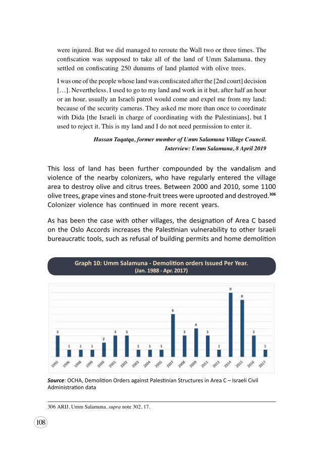
108
wereinjured.ButwedidmanagedtoreroutetheWalltwoorthreetimes.Theconfiscationwas supposed to take all of the land ofUmmSalamuna, theysettledonconfiscating250dunumsof landplantedwitholive trees.
Iwasoneofthepeoplewhoselandwasconfiscatedafterthe[2ndcourt]decision[…].Nevertheless,Iusedtogotomylandandworkinitbut,afterhalfanhouroranhour,usuallyanIsraelipatrolwouldcomeandexpelmefrommyland;becauseofthesecuritycameras.TheyaskedmemorethanoncetocoordinatewithDida[theIsraeli inchargeofcoordinatingwith thePalestinians],butIusedtorejectit.ThisismylandandIdonotneedpermissiontoenterit.
Hassan Taqatqa, former member of Umm Salamuna Village Council. Interview: Umm Salamuna, 8 April 2019
This loss of land has been further compounded by the vandalism and violence of the nearby colonizers, who have regularly entered the village area to destroy olive and citrus trees. Between 2000 and 2010, some 1100 olive trees, grape vines and stone-fruit trees were uprooted and destroyed.306 Colonizer violence has continued in more recent years.
As has been the case with other villages, the designation of Area C based on the Oslo Accords increases the Palestinian vulnerability to other Israeli bureaucratic tools, such as refusal of building permits and home demolition
306ARIJ,UmmSalamuna,supra note302,17.
Graph 10: Umm Salamuna - Demolition orders Issued Per Year. (Jan. 1988 - Apr. 2017)
Source: OCHA, Demolition Orders against Palestinian Structures in Area C – Israeli Civil Administration data
109
orders, which are deployed to control and restrict the lives of Palestinians. In addition, Umm Salamuna has been regularly denied permits to build in Area B. As a result, Umm Salamuna is one of the villages of this area that has had a particularly high number of demolition orders, where at least 56 orders have been issued against structures in the village (see Graph 10). Although, to date most of these orders remain unexecuted, and the construction of a number of houses have been halted by the Israelis due to an apparent absence of authorization.307 The psychological threat of demolition nevertheless remains, causing fear that any day the owner would have their home or agricultural building demolished or be forced to do it themselves.
Additionally, the village faces the isolation and associated measures and threats caused by its proximity to a major colonizer road. Route 3157 was built in 1979, in conjunction with the construction of Efrat colony. It is a shared street between Palestinians and Israelis but is exceptionally dangerous. The high speed limit, and the absence of any real road markings or control, results in numerous accidents. It is also now the main street leading to Umm Salamuna. As a result, the village approached the Israelis to bring some order to the street but their only response has been to put responsibility back to the Palestinian Authority.308 With no other option, villagers continue to use the road, but it has the effect of isolating the village from other nearby Palestinian localities to the north, which previously had enjoyed continuity.
Marah Rabah
Marah Rabah is a Palestinian village, with a history dating back 350 years. Its 1727 inhabitants originate primarily from the nearby Palestinian towns of Beit Fajjar and Tuqu’, which date back thousands of years, having likely moved out for agricultural purposes. It sits on rolling green hills about halfway between Bethlehem and Hebron. Historically, it has been a village that has thrived on agriculture and livestock for its economy. However, in the last 20 years or so, its economy has shifted towards greater reliance on its stone quarries and industrial enterprises, such that almost half the population was dependent on
307“TheIsraelioccupationforcestostoptheconstructionoffourhousesinthevillageofUmmSalamuna”,Shasha, 2June2015,availableathttps://www.shasha.ps/news/144339.html[accessed20June2019].
308InterviewwithHassanTaqatqa,formermemberofUmmSalamunaVillageCouncil.Interview:UmmSalamuna,8April2019.
110
this industry by 2010. 309 This shift is likely a result of both severely diminished water access, with Marah Rabah reportedly only accessing an average of 46 liters per day per capita,310 and Israeli policies restricting the viability of the agricultural market just as they have in other areas.
The village of Marah Rabah is largely located in lands designated as Area B (84.5 percent), which makes it less vulnerable to land confiscation, but not immune. Marah Rabah lies immediately south and west of two major colonizer roads, Routes 3157 and 356, which facilitate connectivity between the eastern area of the Colonial Bloc and Etzion’s epicentre. To that end, Israel is targeting the village lands designated Area C.
WearefortunateinthevillageofMarahRabahthatmostofthevillagelands (about 5000 dunums) are located in Area B. Although some,approximately 1,500 dunums, the lands in the north-eastern part arewithinAreaC,wherewearenotallowedtobuildorcultivate.Therefore,itistargetedforexpropriation.Wheneverweplantoliveoralmondstrees,colonizerscomeanduprootthemunderthesupervisionandassistanceofthe Israeli army.Wheneverwehave tried to invest in it, they [Israelis]come and confiscate our equipment under military orders stating thattheseare“unsafelands”ora“militaryzone”.Asalawyer,Itrytosolvesuchissuesthroughtheirlegalsystem,butusuallytheyaretheoneswhobreak the laws and create facts on the ground by force… all of landslocatedinAreaCareprivatepropertiesownedbythevillagers,whohaveall the legalpapers (Tabou)andother landownershippapers issuedbythe[OttomanandJordanian]LandAuthorities.Theyhaveinheritedthemfrom their grandfathers since the Ottoman Empire.We, in the VillageCouncil, haveworkedon this issue, andwehavemade sure that everyvillager has theproper ownershippapers.
Mr Hussein Al-Sheikh, lawyer and resident of Marah Rabah, Head of the Village Council.
Interview: Marah Rabah, 11 April 2019.
The greater concern for the village is that being largely Area B, it still remains under full security control of Israel. One of the mechanisms regularly deployed by Israel to control the Palestinian population is to place roadblocks, gates and partial checkpoints at the main and secondary entrances to many towns 309ARIJ,MarahRabahvillageprofile,2010,9,availableathttp://vprofile.arij.org/bethlehem/pdfs/VP/
Marah%20Rabah_vp_en.pdf310Ibid.
111
and villages in this area, particularly those located along colonizer bypass roads. In the case of Marah Rabah, after several years of occasionally placing roadblocks on the main entrance to the village,311 in 2017, Israel installed an iron gate allowing the military to regularly shut down the village’s main entrance.312 The village is often shut down by closure of the iron gate.
SimilartoanyotherPalestinianvillage,wesufferfromtheIsraelipoliciesof closure and lack of freedom ofmovement. But thismakes us resilienttoconfront thechallengeofholdingon toour land,although themajorityof the village entrances face closures throughout the year. This happensparticularly because our village lies between Bethlehem andHebron.WearelocatedattheextremesouthofBethlehemandthenorthernmostareaofHebron.Althoughourvillageisapeacefulvillage,IsraelioccupationforcesautomaticallyclosesthevillagewheneveranysecurityeventoccursineitherBethlehemorHebron,accordingtotheIsraelis.TheIsraelisinstalledametalgateatthevillage’smainentrancesotheycanseparateusfromtherestofthePalestinianareas.Unfortunately,this[closure]happensmorethanonceaweek,whichforcesustotaketheroughdirtroadstogetoutofthevillage.Forexample,therouteismorethan30kilometerstoBethlehem,insteadof15kilometerswhenit’s[thegate]open.
Mr Hussein Al-Sheikh, lawyer and resident of Marah Rabah, Head of the Village Council.
Interview: Marah Rabah, 11 April 2019.
The right to freedom of movement is enshrined in Article 12 of the International Covenant on Civil and Political Rights (ICCPR). Palestinians experience a comprehensive system of restrictions on their freedom of movement, that include the physical restrictions, such as roadblocks and checkpoints, the administrative restrictions, such as permits, but also the intangible restrictions that arise from the fear of Israeli military and colonizer violence. In this area,
311POICA, “Israeli Violations in the Occupied Palestinian Territory - July 2016 Israel Defies theInternational Community and approved plans and published tenders to construct more than 2500housing units“,ARIJ, 8August 2016, available at http://poica.org/2016/08/israeli-violations-in-the-occupied-palestinian-territory-july-2016-israel-defies-the-international-community-and-approved-plans-and-published-tenders-to-construct-more-than-2500-housing-units/; POICA, “BethlehemEastern Rural facing Strangulated“, ARIJ, 25 July 2016, available at http://poica.org/2016/07/bethlehem-eastern-rural-facing-strangulated/ [all accessed 20 June 2019].
312POICA,“TheIsraeliOccupationForcessetupirongateonthesouthernentrancetothevillageofMarahRabahinBethlehemGovernorate”,ARIJ,13August2017,availableathttp://poica.org/2017/08/the-israeli-occupation-forces-set-up-iron-gate-on-the-southern-entrance-to-the-village-of-marah-rabah-in-bethlehem-governorate/[accessed20June2019].
112
Marah Rabah is not unique. In fact, in recent years Israel has installed or is in the process of installing roadblocks and gates on most Palestinian villages of the area. This provides Israel with the capacity at will to severely hamper or completely halt the movement of over 40,000 Palestinians in the area. At the same time, these tactics enhance the movement and sustain the presence of less than 5000 colonizers who reside in the eastern cluster of Etzion Colonial Bloc. This degree of restriction on the freedom of movement is so oppressive and strategic, it amounts to a policy that deliberately disrupts the social and economic lives of Palestinians. To do so arguably constitutes a denial of the right to self-determination, which is a breach of a peremptory norm of international law, and is an example of an apartheid policy.
In addition, we have suffered constant and very violent attacks from thecolonizerswhosettlenearby.Asyoucansee,wearesurroundedbyaseriesof colonies of Efrat, Tekoa and other colonies. Unfortunately, colonizerssometimesstopatthemainentranceofthevillageandpreventusfrompassing,either entering or leaving the village.
Alltheseviolationsandpoliciesnegativelyaffectus.Universitystudents,forexample,havetotakealternatelongerroadstoreachtheiruniversitiesandthenit’shardforthemtobecommittedtoattendtheirlectures.Teachers,similartootheremployees,areusuallylatetoarriveattheirjobs.Factoriesinthevillagearealsoaffectedwhentheyareunabletomeettheirdeadlines.
[During]Thearrestcampaignsthatusuallytakeplacelateatnight,itissoclearthatthey[Israelis]aretargetingthechildren,14-15yearsold.Itisabrutalkindofarrest,subjectingthemtophysicalandpsychologicalilltreatment,includingseverebeatings,insults,solitaryconfinement,andthreatsandintimidationtocoerce confessions.Aiming to break them, break their families in order tomakethemobedienttotheirorders.
Mr Hussein Al-Sheikh, lawyer and resident of Marah Rabah, Head of the Village Council.
Interview: Marah Rabah, 11 April 2019.
These night incursions are a regular occurrence in Marah Rabah, as well as other nearby towns such as Beit Fajjar and Tuqu’, and in the course of them youth are regularly and brutally arrested by the Israeli military.313 This is part of a consistent policy of suppression enforced by Israel across the West
313“TheOccupationhandsoverayoungmanfromthevillageofMarahRabah:anintelligencereport”,WAFA,7February2019,availableathttps://bit.ly/2IsPos5[inArabic][accessed20June2019].
113
Bank, including east Jerusalem. In 2018, Israel conducted an average of 86 raids per week across the West Bank; this was up from 64 per week in 2017, and in 2019, at date of publication, Israel had been conducting 90 raids per week.314 During these campaigns of mass arrests, often children (12-17 years old), especially boys, are the first to be targeted and arrested.315 According to Addameer, in 2018 alone, children made up 17 percent of arrests carried out by Israel against Palestinians; in other words, 1080 children were arrested by Israel.316 As the testimony shows, these arrests are often brutal, involve the besiegement of a whole community, and too frequently result in the murder of the Palestinian being targeted or bystanders.317 This serves to generate significant psychological fear across the community as a result of a raid being conducted and the inherent risk it presents. It is a policy designed specifically to suppress resistance to Israel’s presence and policies, and ultimately force the transfer of the population out of the area.
314OCHA, Protection of Civilians Report | 23 April - 6 May 2019,9May2019,availableathttps://www.ochaopt.org/poc/23-april-6-may-2019[accessed20June2019].
315BADIL,SuppressionofResistance,supra note,204,63.316“JointAnnualReport:Around 6500Arrests in 2018”,Addameer, 31December 2018, available at
http://www.addameer.org/publications/joint-annual-report-around-6500-arrests-2018 [accessed 20June 2019].
317“NightRaids”,The Electronic Intifada, 2019,availableathttps://electronicintifada.net/tags/night-raids[accessed20June2019].
114
5. Annexation of the Etzion Colonial Bloc
Since Palestine was not a so-called “land without people, for a people without a land” as implied by Zionists in the early period of its inception, the establishment of Israel was necessarily going to require an incremental process involving both the forcible transfer of the indigenous Palestinian population out of Palestine and the colonization of the desired Israeli-Jewish population. To this end, Zionist acceptance of the 1947 Partition Plan was a politically expedient decision that would enable and enhance the realization of the Israeli state in all of Mandatory Palestine. As David Ben-Gurion, the first Prime Minister of Israel said in 1938 at the World Zionist Congress, “I am not satisfied with part of the country, but on the basis of the assumption that after we build up a strong force following the establishment of the state – we will abolish the partition of the country and expand to the whole land of Palestine.”318
While the mechanisms Israel has used and continues to use have been vast, complicated and at certain periods not highly visible, the ultimate objective has not changed. However, more recently, the colonization of the oPt and the forcible transfer of its indigenous Palestinian population has found resonance in the Trump administration. As such, today, this Zionist objective and the policies utilized to achieve it have noticeably crystalized and this is most aptly demonstrated in the case of Etzion Colonial Bloc. This next section will look at the way Israel has already de facto annexed the area at the epicenter of Etzion, as well as the colonies of the eastern bloc, and is slowly expanding this annexation to the land to the east and south of this area.
5.1 Legal Framework: Annexation
Annexation is the act of forcibly acquiring territory, and is an act which
318Sean F.McMahon (ed.), The Discourse of Palestinian-Israeli Relations: Persistent Analytics and Practices (NewYork, 2010), 40.
115
violates the peremptory norm prohibiting the use of force.319 Annexation is generally understood to involve the following two elements: “the effective occupation of the territory in question and the clear intention to appropriate it permanently (corpus et animus).”320
The general prohibition on territorial acquisition is governed by the principles of jus ad bellum, and is the corollary of the prohibition on the use of force. Historically, “annexation was usually effected by a unilateral declaration after the [military] conquest of the territory in question and the final defeat of the adversary,”321 Further, the use of force to acquire territory was considered lawful alongside the other means of acquiring territory: acquisition of terra nullius,322 cession, prescription, and accretion.323 However, following World War I, the 1919 Covenant of the League of Nations determined that the Members of the League would “undertake to respect and preserve as against external aggression the territorial integrity and existing political independents of all Members of the League.”324 Today, the prohibition on the use of force is enshrined by Article 2(4) of the UN Charter, which prohibits states from exercising “the threat or use of force against the territorial integrity or political independence of any state.”325 The 2001 Draft Articles on the Responsibility of States for Internationally Wrongful Acts reinforce that the threat or use of force is forbidden even when it is used as a countermeasure against another state’s wrongfulness.326 Numerous UN General Assembly and Security Council resolutions as well as other international treaties also confirm the prohibition on the threat or use of force and characterize such an act as a crime of aggression.327
319 RainerHofmann, “Annexation,”Max Planck Encyclopedia of Public International Law, February2013,para.1[hereinafterHofmann,Annexation];Lynk,ReportonHumanRights,supranote36,10.
320 Hoffman,Annexation,supra note319,para. 1.321 Id.,para.2.322 Defined as “territory not annexed by any nation”. Merriam-Webster Dictionary, “terra nullius”,
available at https://www.merriam-webster.com/dictionary/terra%20nullius [accessed 20 June 2019].323 Hofmann,Annexation,supra note319,para. 1.324CovenantoftheLeagueofNations,art.10,1919.325UNCharter,art.2,1945.326InternationalLawCommission,Draft Articles on Responsibility of States for Internationally Wrongful
Acts, with commentaries, November 2001, Supplement No. 10 (A/56/10), chp.IV.E.1,Articles 22and 50, available at http://legal.un.org/ilc/texts/instruments/english/commentaries/9_6_2001.pdf [hereinafter ILC,DraftArticles on StateResponsibility].
327 Article5(3)GAresolution3314(XXIX)onthedefinitionofaggression;citeotherUNGAandUNSCresolutionsonthreatoruseofforce;Article4and5,DeclarationontheStrengtheningofInternationalSecurity (UNGARes.2734(XXV),whichmentions territorial integrityasacrucialelementof thesovereignequalityofallstates;theHelsinkiFinalAct;SecurityCouncil.
116
In other words, no derogations from the prohibition on the threat or use of force are permitted, other than the two exceptions outlined in the UN Charter.
It follows, therefore, that force cannot be used to acquire territory. Such a binding prohibition against annexation has been endorsed by leading public international law scholars.328 The United Nations General Assembly (UNGA) unanimously codified the prohibition in the 1970 Declaration on Principles of International Law concerning Friendly Relations and Co-operation among States, in accordance with the UN Charter, which states that “the territory of a State shall not be the object of acquisition by another State resulting from the threat or use of force. No territorial acquisition resulting from the threat or use of force shall be recognized as legal.”329 It is a position subsequently upheld by the ICJ in its Advisory Opinion on South West Africa in 1971.330 It is also reinforced by Article 52 of the Vienna Convention on the Law of Treaties, which holds that any treaty procured by the threat of or use of force is void, thereby prohibiting annexation by treaty.331 In fact, legal scholar, Dr. Rainer Hoffman, notes that “[…] in view of the pertinent consistent and uniform State practice it is beyond any doubt that, under present international law, the prohibition of annexation and the obligation not to recognize it as lawful (Stimson Doctrine) extend beyond treaty obligations and form part of customary international law”332 […] with the rank of jus cogens.”333 To that end, the unlawfulness of annexation by force was enshrined as a crime of aggression under Article 8(2)(a) of the Rome Statute. 334
328M.Shaw, International Law (Cambridge:CambridgeUniversityPress, 2017) (8th ed.), at 372 (“Itis,however,cleartodaythat theacquisitionof territorybyforcealoneis illegalunderinternationallaw”);andA.Cassese,International Law(Oxford:OxfordUniversityPress,2005)(2nded.),at57(“...conquestdoesnottransferalegaltitleofsovereignty,evenifitisfollowedbyde factooccupation,andassertionofauthorityovertheterritory.”),citedinLynk,ReportonHumanRights,supranote36,10.
329 G.A.Res.2625(XXV),U.N.GAOR,25thSess.,1883rdplen.mtg.,at123,U.N.Doc.A/8082(Oct.24,1970).
330LegalConsequencesforStatesof theContinuedPresenceofSouthAfrica inNamibia (SouthWestAfrica),AdvisoryOpinion,1971ICJ16,21June1971,para.53and83,availableathttp://www.icj-cij.org/files/case-related/53/053-19710621-ADV-01-00-EN.pdf
331UnitedNations,Vienna Convention on the Law of Treaties,1155UNTS331,23May1969,Art.52,available at http://www.refworld.org/docid/3ae6b3a10.html [accessed 20 June 2019].
332 Hofmann,Annexation,supra note319,para21;ForStimsonDoctrineseesectionon“ObligationsofThirdPartyStates:Non-recognition”.
333 Hofmann,Annexation, supra note319,para38. 334RomeStatuteoftheICC,supra note21,art.8(2)(a).
117
The lawful Use of Force and Territorial Acquisition
As mentioned, there are exceptions in the UN Charter to the prohibition on the threat or use of force. The first of those exceptions is defined by Article 51 as the right to self-defense.335 The second exception is the authorization of the use of force by the UN Security Council, under Chapter VII of the UN Charter. However, these provisions cannot be used to justify territorial acquisition by force, as sovereignty is an inalienable right.336 In other words, sovereignty is recognized by contemporary international law as vesting in the people, in this case the Palestinian people, and not the territory itself. Sovereignty is inextricably linked to the expression of the right to self-determination,337 without which the jus cogens principle would be illusory. As already discussed in preceding chapters, territorial integrity is integral to and an extension of the right to self-determination, and therefore sovereignty over the territory is connected to the expression of self-determination and cannot be transferred through authorized use of force.
In respect to the self-defense argument, it is conceivable that such a situation could occur when a state attempts to justify the annexation of territory belonging to an aggressor state in order to prevent future attacks. However, even in situations of legitimate self-defense, “acts such as the de jure or de facto annexation of territory […] would normally be regarded as going beyond the ambit of what was justifiable, a proposition reinforced by United Nations practice in relation to the [sic] Israeli occupied territories.”338 In other words, even if the use of force was legal, any acquisition of territory subsequent to that use of force would be illegal. A situation of occupation does not change this position. In fact, it strengthens it, as an OP cannot invoke the right to self-defense under the UN Charter to justify the use of force against those over whom it exercises effective control and to whom it owes protection obligations under IHL.339 Therefore, self-defense also cannot be used to justify the annexation of territory under occupation.
335UNCharter,art.51,1945.336B-Naftali,Occupation:ExceptionalCaseoftheoPt,supranote18,136.337Id.,134-135.338 D.W.Greig,“Self-DefenseandtheSecurityCouncil:WhatDoesArticle51Require?” International &
Comparative Law Quarterly40,no.2(April1991):401.339See:NouraErakat,“No,IsraelDoesNotHavetheRighttoSelf-DefenseInInternationalLawAgainst
Occupied Palestinian Territory”, Jadaliyya, 11 July 2014, available at https://www.jadaliyya.com/Details/27551[accessed20June2019];JohnDugard,“DebunkingIsrael’sself-defenseargument”,Aljazeera, 31 July 2014, available at http://america.aljazeera.com/opinions/2014/7/gaza-israel-internationalpoliticsunicc.html [accessed 20 June 2019].
118
De Facto and De Jure Annexation
Situations where the OP expresses explicit intent and undertakes formal legal steps to declare its annexation of part or all of an occupied territory, are generally considered de jure annexations. east Jerusalem exemplifies de jure annexation, wherein Israel illegally annexed Jerusalem by a Cabinet decision in June 1967, which was consolidated by legislation passed expanding the borders of Jerusalem.340 It was formally annexed in 1980 and reiterated in 2018 when it declared in its Basic Laws, the constitutional laws of Israel, that “Jerusalem, complete and united, is the capital of Israel.”341
However, due to the prohibition on the threat or use of force to acquire territory, states are usually not explicit in their intent to annex. Instead evidence of annexation is proven by reference to the policies and actions of the OP towards the occupied territory so as to establish implicit intent to annex territory.342 This situation is known as de facto annexation. More specifically, such a situation would have arisen where there is evidence of:
1. the intention to annex demonstrated by official plans, policies and comments;
2. the extension of sovereignty to the territory in the form of domestic laws; and
3. the installation of facts on the ground which indicate a situation of permanence and sovereignty.
Each of these might be demonstrated by the effectiveness of the control exerted, the application of domestic laws to occupied territory, the transfer of population, the development of infrastructure to support permanency, (such as roads), and the granting of citizenship. The degree to which the presence or absence of each of these factors is determinative of a situation of de facto annexation depends on the circumstances of the specific situation under consideration. In other words, a state is in violation of the
340TheCivicCoalition forDefendingPalestinians’Rights in Jerusalem,Aggressive Urbanism: Urban Planning and the Displacement of Palestinians within and from occupied east Jerusalem, December2009, 34,availableathttps://www.civiccoalition-jerusalem.org/uploads/9/3/6/8/93682182/aggressive_urbanism.pdf[hereinafterAggressiveUrbanism].
341 BasicLaw:Jerusalem,CapitalofIsrael,5740-1980,SHNo.980,(Isr.);BasicLaw:Israel-theNationStateoftheJewishPeople,5778-2018,(Isr.)AnEnglishtranslationofthelawisavailableathttps://knesset.gov.il/laws/special/eng/BasicLawNationState.pdf[hereinafterJewishNationStateLaw].
342 Azarova,ProlongedOccupation,supra note32.
119
prohibition on annexation if the state has “displayed a pattern of behavior sufficiently consistent with annexation, and inconsistent with the right to self-determination and the fundamental principles of occupation, including temporality, trusteeship and good faith.”343 The following sections address each of the three criteria above clearly indicating a situation of de facto annexation that is creeping towards de jure annexation.
5.2 The Israeli Intent to Annex the Etzion Colonial Bloc
Development and Expansion of Jerusalem
Israeli plans demonstrating the intention to annex areas of the oPt, including the region of the Etzion Colonial Bloc, have a long history starting with the Allon Plan, presented in 1967. This plan included the establishment of Israeli colonies in the West Bank and the Gaza Strip, and annexation of large, strategically located areas of the West Bank, including the Jordan Valley, areas near Tulkaram and Qalqilya, and the area of Greater Jerusalem.344 Guided by this plan, by 1982 Israel had established 98 colonies in the West Bank.345
In respect of the Etzion Colonial Bloc, Israeli plans regarding Jerusalem are particularly significant. As its declared capital, Israel has adopted numerous plans and policies that are directed at strengthening the Israeli claim to sovereignty of Jerusalem, thereby ensuring future international recognition as the capital of Israel. To that end, Israel’s plans explicitly seek to (a) ensure an Israeli-Jewish majority and (b) an indivisible city structure.346 However, given the sizeable population of Palestinians living in Jerusalem, and their significantly higher population growth, achieving and maintaining these two objectives has involved 1) dramatic expansion of the municipal boundaries while minimizing and isolating the Palestinian communities, 2) creation of conditions, particularly living conditions, to incentivize Israeli-Jewish colonization, and 3) establishment of a coercive environment for the existing Palestinian communities to limit and reduce their population. 343Lynk,ReportonHumanRights,supranote36,9.344AllisonBHodgkins,Israeli Settlement Policy in Jerusalem: Facts on the Ground, PASSIA,(Jerusalem,
1998):80.[hereinafterHodgkins,SettlementPolicy].345Benvenisti,WestBank,supra note162,50.346JerusalemDevelopmentAuthority, Jerusalem: Extending the Area of Jurisdiction,Municipality of
JerusalemCity PlanningDepartment,April 1991, 25.
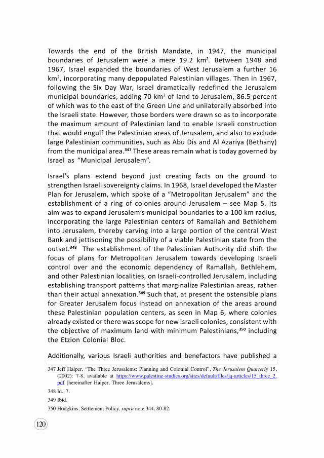
120
Towards the end of the British Mandate, in 1947, the municipal boundaries of Jerusalem were a mere 19.2 km2. Between 1948 and 1967, Israel expanded the boundaries of West Jerusalem a further 16 km2, incorporating many depopulated Palestinian villages. Then in 1967, following the Six Day War, Israel dramatically redefined the Jerusalem municipal boundaries, adding 70 km2 of land to Jerusalem, 86.5 percent of which was to the east of the Green Line and unilaterally absorbed into the Israeli state. However, those borders were drawn so as to incorporate the maximum amount of Palestinian land to enable Israeli construction that would engulf the Palestinian areas of Jerusalem, and also to exclude large Palestinian communities, such as Abu Dis and Al Azariya (Bethany) from the municipal area.347 These areas remain what is today governed by Israel as “Municipal Jerusalem”.
Israel’s plans extend beyond just creating facts on the ground to strengthen Israeli sovereignty claims. In 1968, Israel developed the Master Plan for Jerusalem, which spoke of a “Metropolitan Jerusalem” and the establishment of a ring of colonies around Jerusalem – see Map 5. Its aim was to expand Jerusalem’s municipal boundaries to a 100 km radius, incorporating the large Palestinian centers of Ramallah and Bethlehem into Jerusalem, thereby carving into a large portion of the central West Bank and jettisoning the possibility of a viable Palestinian state from the outset.348 The establishment of the Palestinian Authority did shift the focus of plans for Metropolitan Jerusalem towards developing Israeli control over and the economic dependency of Ramallah, Bethlehem, and other Palestinian localities, on Israeli-controlled Jerusalem, including establishing transport patterns that marginalize Palestinian areas, rather than their actual annexation.349 Such that, at present the ostensible plans for Greater Jerusalem focus instead on annexation of the areas around these Palestinian population centers, as seen in Map 6, where colonies already existed or there was scope for new Israeli colonies, consistent with the objective of maximum land with minimum Palestinians,350 including the Etzion Colonial Bloc.
Additionally, various Israeli authorities and benefactors have published a
347JeffHalper, “TheThree Jerusalems:PlanningandColonialControl”,The Jerusalem Quarterly 15,(2002): 7-8, available at https://www.palestine-studies.org/sites/default/files/jq-articles/15_three_2.pdf [hereinafterHalper,Three Jerusalems].
348Id.,7.349Ibid.350Hodgkins,SettlementPolicy,supra note344,80-82.
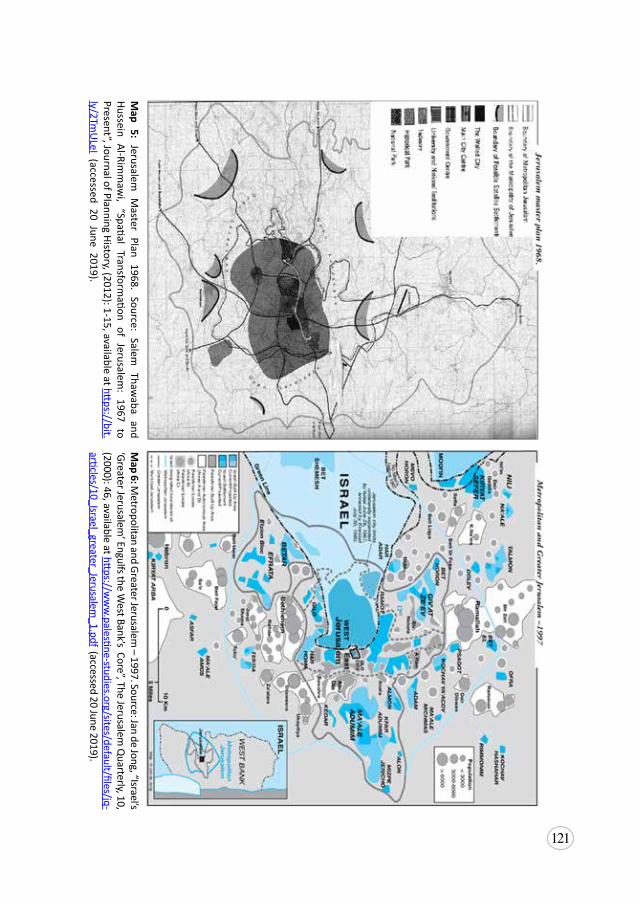
121
Map 5: Jerusalem
Master Plan 1968. Source: Salem
Thawaba and
Hussein Al-Rimm
awi, “Spatial Transform
ation of Jerusalem: 1967 to
Present”, Journal of Planning History, (2012): 1-15, available at https://bit.
ly/2TmU
LeI (accessed 20 June 2019).
Map 6: M
etropolitan and Greater Jerusalem – 1997. Source: Jan de Jong, “Israel’s
‘Greater Jerusalem’ Engulfs the W
est Bank’s Core”, The Jerusalem Q
uarterly, 10, (2000): 46, available at https://w
ww
.palestine-studies.org/sites/default/files/jq-articles/10_Israel_greater_Jerusalem
_1.pdf (accessed 20 June 2019).
122
number of plans which inform the development of Jerusalem,351 including some that expressly incorporate the Etzion Colonial Bloc in the vision for Jerusalem.
Israeli Statements of Intent
When it comes to Israeli discourse on the Etzion Colonial Bloc it is purposely obtuse and unclear as to whether the discourse refers only to the epicenter that was the initial area of Gush Etzion, or whether it includes the full extension of the Etzion Colonial Bloc. This nebulous nature of the discourse allows the Israeli state to build support for annexation of an ever-expanding area.
In that regard, intentions with respect to the Etzion Colonial Bloc have been made clear by numerous high-level Israeli officials, including the specific call for the annexation of the Etzion Colonial Bloc and other parts or all of the West Bank. Prominent examples include:
• In 1995, then Prime Minister, Yitzhak Rabin said: “we envision and want [a] united Jerusalem, which will include both Ma’ale Adumim and Giv’at Ze’ev – as the Capital of Israel, under Israeli sovereignty…changes will include the addition of Gush Etzion, Efrat, Beitar and other communities, most of which are in the area east of what was the ‘Green Line’ prior to the Six Day War.”352
• On 25 July 2000, at the Camp David press conference, subsequent Prime Minister, Ehud Barak, spoke of, “the growth of Jerusalem…through taking some of the cities surrounding Jerusalem – Ma’ale Adumim, Givat Ze’ev, the Etzion bloc – attaching them to Jerusalem and placing them under Israeli sovereignty, thus creating a situation in which the whole world recognizes this expanded Jerusalem as Israel’s capital, at a price of transferring a few [Palestinian] villages…”353
351Planning Administration, City Engineer, City Planning Department, The 2000/2020 Jerusalem Master Plan, prepared for JerusalemMunicipality, 2000, available at http://www.alhaq.org/en/wp-content/uploads/2018/03/LocalOutlinePlanJerusalem2000.pdf; The Civic Coalition for DefendingPalestinians’RightsinJerusalem,“The2030JerusalemMasterPlan”,inAggressiveUrbanism,supra note 340, 26; NurArafeh, “TheMarom Plan” inWhich Jerusalem? Israel’s Little-Known Master Plans, 31May2016,availableathttps://al-shabaka.org/briefs/jerusalem-israels-little-known-master-plans/;andMetropolitanJerusalemMovingForward,“TheGreaterJerusalemTransportationPlan”,2013, available at https://www.polisnetwork.eu/uploads/Modules/PublicDocuments/jerusalem-transportation-master-plan.pdf [all accessed 20 June 2019].
352Francesco Chiodelli, Shaping Jerusalem: Spatial planning, politics and the conflict (New York:Routledge, 2017).
353Halper,ThreeJerusalems,supra note347,12.
123
• In June 2014, the Israeli security cabinet discussed creating a committee to develop the criteria for annexing Etzion to Israel.354 Israeli Minister of Economy, Naftali Bennet, is the main supporter of this initiative and has proposed the annexation of all Area C to Israel on more than one occasion.355
• In May 2015, Likud Knesset Member, Nava Boker, expressed her intention to promote legislation to annex the Etzion Colonial Bloc to Israel.356
• In January 2017, then Israeli Defense Minister, Avigdor Lieberman, in discussing the bill to annex the Etzion Colonial Bloc among others, stated the need for patience with the new US administration, but said, “it is clear that at the end of the day, in one way or another, Ariel, Ma’aleh Adumim and Gush Etzion, will be part of Israel.”357
• On 26 July 2017, Israeli Prime Minister, Benjamin Netanyahu, expressed his support for a bill that would incorporate four colonies – including Beitar Illit, Efrat and the Etzion bloc – into the Jerusalem Municipality.358 The proposal would further extend Israel’s sovereignty over colonies in the oPt, for example by enabling the residents of those colonies to vote in the Jerusalem municipality elections, thus further de facto annexing Palestinian land.
• A week later, on 2 August 2017, Netanyahu announced, “we are working energetically for settlement in every part of the land,”359 the following day proudly adding that “no other government has done as
354CarolineGlick, “WorldNews:Weekof June29 through July5”,Focuson Jerusalem, available athttps://focusonjerusalem.com/newsroom167.html [accessed 20 June 2019].
355“AfterUNvote,Bennettplans tobringannexationbill toKnesset”,Times of Israel, 25December2016,availableathttp://www.timesofisrael.com/after-un-vote-bennett-plans-to-bring-annexation-bill-to-knesset/ [accessed20June2019].
356MazalMualem,“MKNavaBokeraims todefenddiversity inLikud”,Al- Monitor, 15April2015,available at http://www.al-monitor.com/pulse/originals/2015/04/israel-new-knesset-neva-boker-interview-firefighting-carmel.html [accessed 20 June 2019].
357TovahLazaroff,“Liberman:‘TheUSCouldAgreetoSettlementBlocAnnexation,ButNotNow’”,The Jerusalem Post, 19January2017,availableathttp://www.jpost.com/Israel-News/Liberman-The-US-could-agree-to-settlement-bloc-annexation-but-not-now-478962 [accessed 20 June 2019].
358MarissaNewman,“NetanyahubacksmajorexpansionofJerusalemto includenearbysettlements”,The Times of Israel, 27July2017,availableathttps://www.timesofisrael.com/netanyahu-backs-major-expansion-of-jerusalem-to-include-nearby-settlements/ [accessed20 June2019].
359 Tovah Lazaroff, “Netanyahu: ’We’re Connecting the Beitar Illit Settlement to Jerusalem’”, The Jerusalem Post, 3 August 2017, available at http://www.jpost.com/Israel-News/Politics-And-Diplomacy/Netanyahu-Were-connecting-Beitar-Illit-settlement-to-Jerusalem-501512 [accessed 20June 2019].
124
much for settlement in the land of Israel as the government which I lead.”360
• In September 2017, at the 50-year Jubilee celebrations for establishment of the Etzion Colonial Bloc, Netanyahu not only attended, but also said that: “settlement is important to you my friends, it is equally important to me, so I say before all and clearly: There will be no more uprooting of settlements in the Land of Israel.”361
• In November 2017, Jerusalem Affairs Minister, Ze’ev Elkin, said, “Halas (enough) with the story of two states. There is no other option but the state of Israel, certainly between the Jordan [River] to the sea there will be one state.”362
• On 20 December 2017, Minister of Justice, Ayelet Shaked, said, “the registration of the land of Kfar Etzion as the land of the Jewish National Fund is an important step, both symbolically and practically, in order to continue our hold on Gush Etzion and the Land of Israel….I am hopeful that the day is not far off that we will be able to advance another step of expression of this belonging: to apply full Israeli sovereignty over all the areas of Gush Etzion, as well as Ma’aleh Adumim and Area C.”363
• On 31 December 2017, the ruling party of Israel, Likud, passed a resolution calling for the annexation of the colonies, saying “Fifty years after the liberation of Judea and Samaria, and with them Jerusalem, our eternal capital, the Likud Central Committee calls on Likud’s elected leaders to work to allow unhindered construction and to extend Israeli law and sovereignty in all the areas of liberated settlement in Judea and Samaria.”364
360“Netanyahuboastsabouthowmuchhisgovernmenthasdonefor illegalsettlementsonPalestinianland”,The New Arab, 3August2017,availableathttps://www.alaraby.co.uk/english/news/2017/8/3/netanyahu-no-other-government-did-as-much-for-settlement [accessed 20 June 2019].
361Tovah Lazaroff, “Netanyahu at Settlement Jubilee: ‘We will never uproot Jewish or ArabCommunities’”, The Jerusalem Post,28September2017,availableathttps://www.jpost.com/Israel-News/Netanyahu-We-wont-uproot-Jews-Arabs-506163 [accessed 20 June 2019].
362TovahLazaroff,“Elkin:StartPreparingforOneMillionSettlersintheWestBank”,The Jerusalem Post, 14November2017,availableathttps://www.jpost.com/Israel-News/Elkin-Start-preparing-for-one-million-settlers-in-the-West-Bank-514251 [accessed 20 June 2019].
363“Weshouldachievefullsovereigntysoon”,Arutz Sheva, 20December2017,availableathttp://www.israelnationalnews.com/News/News.aspx/239594[accessed20June2019].
364JacobMagid,“LikudtopbodyvotestourgeannexingpartsoftheWestBank”,Times of Israel,31December2017, availableathttps://www.timesofisrael.com/likud-top-body-votes-to-annex-parts-of-the-west-bank/ [accessed20June2019].
125
Israeli Intent Through Legislation
These statements have been further reinforced by various legislative efforts, including 25 bills introduced to the Knesset seeking to annex all or part of the West Bank and six attempts specifically concerning ‘Gush Etzion’.365 Between March and June 2017, three identical bills called “Annexation of Etzion bloc bill” were introduced by three different Knesset Members. The explanatory remarks noted that “[t]herefore, now is the time to apply [Israeli] sovereignty to these areas, including all the settlements of Gush Etzion Regional Council, Efrat and Beitar Illit, including their commercial and industrial areas, archaeological sites, roads, and all state land between the settlements, located in Area C.”
Also in 2017, there were a further three attempts to introduce bills to annex the colonies surrounding Jerusalem, including the areas containing Ma’ale Adumim, Givat Ze’ev, Gush Etzion, Beitar Illit and Efrat, to Jerusalem. Each attempt has been similar to the others, and they have variously been known as the “Greater Jerusalem Law” and the “Jerusalem and its Daughters” law.366 None of these bills have been adopted or withdrawn, rather put on hold following pressure from the United States pending the release of the Deal of the Century.367
In 2018, Netanyahu blocked the progress of another bill, entitled Annexation of the Entire West Bank, this time aiming at extending Israeli sovereignty to all colonies in the West Bank and in effect annexing them to Israel.368 However, in taking this action, the Israeli Prime Minister also confirmed that he had been in discussion with the White House, under the Trump Administration, for some time regarding the issue of extending Israeli sovereignty to the
365YeshDin, “AnnexationLegislationDatabase”, available at https://www.yesh-din.org/en/legislation/ [accessed20June2019] [hereinafterYeshDinAnnexationLegislationDatabase].
366TheBillfor“GreaterJerusalem”Law–2017[7555],unofficialEnglishtranslationavailableathttp://www.alhaq.org/en/wp-content/uploads/2018/02/P-20-4158.pdf;andtheBillforthe“JerusalemanditsDaughters”Law - 2017 [7555], unofficialEnglish translation available at http://www.alhaq.org/en/wp-content/uploads/2018/02/P-20-4386.pdf
367JeffreyHeller,“U.S.pressuredelaysIsrael’s‘GreaterJerusalem’bill:legislator”,Reuters, 29August2017, available at https://www.reuters.com/article/us-israel-palestinians-settlement/u-s-pressure-delays-israels-greater-jerusalem-bill-legislator-idUSKBN1CY0CB [accessed 20 June 2019].
368Seeentriesentitled:“AnnexationoftheEntireWestBankBill”,inYeshDinAnnexationlegislationDatabase, supra note 365; Jonathan Lis, “Netanyahu Blocks Settlement Annexation Bill FromComingtoaVote”,Haaretz, 21February2018,availableathttps://www.haaretz.com/israel-news/netanyahu-blocks-settlement-annexation-bill-from-coming-to-a-vote-1.5809143 [accessed 20 June2019].
126
colonies.369 The same bill was reintroduced in May 2018 and remains on hold.370 The attempts are nevertheless indicative of the permanency with which Israel views its investment and colonies in the area, and, as such, these pending bills have clear relevance to an assessment of de facto annexation of the Etzion Colonial Bloc.
Israeli Intent Demonstrated by non-State Actors
Annexation of the Etzion Colonial Bloc has also become a primary call to action for Israeli non-state actors and groups such as The Sovereignty Movement (Ribonut) and the Zehut Party, with their Zehut Peace Plan, and numerous similar groups and movements. With hundreds of thousands of Israeli-Jews having colonized areas throughout the West Bank, these groups view annexation, or “sovereignty”, as the only plausible next step for Israel.371
The Sovereignty Movement is led by the Women in Green, a group from the Israeli far right pushing for the expansion of sovereignty throughout the West Bank.372 The group has gained diplomatic and legislative support and attention, as has their well-established Sovereignty Movement. They frame the discussion in terms of a need for sovereignty over the West Bank due to the colonies, the desire for the expansion of Jerusalem, and the overarching goal of claiming the whole of Palestine and establishing the Israeli state from the Jordan River to the Dead Sea. The Sovereignty Movement has gained support from several Israeli politicians and members of the Knesset, including Minister Yoav Galant, the Minister of Construction, who stated the need to view the “area of the Jordan Valley and Judea and Samaria and all of the area west of them as one unit or territory, which together allows for the defense of the state of Israel.”373 As annexation of the West Bank is presented and
369FoundationforMiddleEastPeace,“BibiBlocksSettlementAnnexationBill,ButSignalsSomethingBigger”, Settlement Report: 15 February 2018, available at https://fmep.org/resource/settlement-report-february-15-2018/#BigSignal[accessed20June2019];TovahLazaroff,“RightWingLeaders:Israelshouldignoretrumponsettlementexpansion”,The Jerusalem Post, 13February2018,availableathttps://www.jpost.com/Israel-News/Right-wing-leaders-Israel-should-ignore-Trump-on-settlement-annexation-542491[accessed20June2019].
370YeshDin,AnnexationLegislationDatabase,supra note365.371“Analysis:So,HowManyArabsLiveinAreaC?”Jewish Press, 10January2016,availableathttps://
www.jewishpress.com/news/analysis-so-how-many-arabs-live-in-area-c/2016/01/10/ [accessed 20June2019][hereinafterAnalysis-AreaC].
372WomeninGreen,“TheSovereigntyMovementonY-Net”,WordPress,12February2019,availableathttps://womeningreen.org/the-sovereignty-movement-on-y-net/[accessed20June2019].
373 “TheRightofourFore-fathersAlignwithSecurityNeeds”,Sovereignty no.10(2018):4,availableathttp://womeningreen.org/wp-content/uploads/2018/05/ribonut10english.pdf [hereinafter Sovereignty Movement].
127
perceived as a security necessity, the Sovereignty Movement continues to gain traction among the Israeli public, as well as influence perceptions of the international community.
As such, the Sovereignty Movement and other groups have intensified the discussions concerning annexation within security and demographic considerations, which have always been presented as impediments to Zionist desires to annex the entire West Bank. On the one hand, the Sovereignty Movement suggests that annexation is seen as an immediate necessity for Area C in order to ensure the maintenance of security and control over the Palestinian population that remains in these areas.374 They also support the extension of partial Israeli citizenship to all Palestinians in these annexed areas, as a first-step initiative to ensure security and facilitate further annexation of the West Bank and Gaza.375 On the other hand, groups such as the Zehut Party dismiss demographic concerns saying Jewish women are having as many babies as Palestinians, while security is said to be a problem because of the pursuit of peace. In other words, Israel should finish the goal it set out to achieve, annexing the entire territory between the Jordan River and the Mediterranean Sea, and it can grant partial citizenship to all Palestinians and incentivize dispersal of the Palestinian population by offering migration packages. 376
5.3 Extension of Israeli Sovereignty into the oPt
As part of its gradual process of de facto annexation, Israel established a convoluted legal system in the oPt that applies one legal framework to Israeli colonizers and another to Palestinians, while ostensibly maintaining the appearance of an occupied territory governed by separate military laws.
Firstly, Israel has achieved effective extension of sovereignty into the oPt through a series of military orders establishing territorial enclaves for the colonies in the West Bank. Among these orders passed in 1979 establishing local authorities for the colonies, were Military Order 783 regarding the management of regional councils – that included the Gush Etzion regional council – and Military Order 892 regarding the management of local councils
374Analysis-AreaC,supra note371.375Ibid.376Zehut,“TheOneStateSolution;Zehut’sPeacePlan”,16July2018,availableathttps://zehut.org.il/
zehuts-peace-plan/?lang=en [accessed 20 June 2019].
128
– such as Efrat.377 These military orders paved the way for the extension of Israeli civil laws into the oPt by allowing the governance structures of the colonies (the local and regional councils) to have the same powers and jurisdiction as other Israeli municipal bodies, meaning they apply Israeli civil laws within their boundaries. As a result, all Israeli ministries and departments that hold statutory authority are able to exercise said authority within the colonies – e.g. the Israeli Ministry of Education has authority over schools in the colonies.378
Secondly, the Knesset has also passed a number of laws that apply to Israeli-Jewish citizens regardless of where they reside, including those who live in colonies. This has meant that many Israeli civil laws, including many criminal laws, laws related to tax, national insurance, health insurance and the right to vote in local, regional and Knesset elections, apply to all colonizers by virtue of their Israeli citizenship alone.379
Thirdly, Israel extended service delivery to the colonies, thus extending their sovereignty beyond legal boundaries. For example, by way of Military Order 1219 (also listed as 1216), Israel allowed the colonies to connect directly to the Israeli electricity grid, stating that “by 12 January 1988, Israel authorizes the switch-over for a number of settlements, which constitutes another step in the legal annexation of settlers and settlements into Israel.”380 Ordinarily, electricity had been provided by the Jerusalem District Electricity Company, a Palestinian company holding the license from Ottoman times, and as per occupation law, maintained the legal right to provide electricity as the prior license holder.381 In allowing this switch, the military order marked an important step in Israel’s process of de facto annexation of the colonies.
The Israeli Supreme Court extended its own jurisdiction to cover colonies in the oPt in 1972, finding it “had the power to judicially review any military activity taken beyond the borders of the Israeli democracy.”382 In turn, the courts have validated this system, upholding and regularizing the application of distinct military orders and Israeli civil law to the colonizers in the
377 BADIL,RulingPalestine,supra note228,109-110.378Tilley,Occupation,Colonialism,Apartheid,supranote40,106-107.379“An Israeli Guide toAnnexation”, The Nakba Files, 23 June 2016, available at http://nakbafiles.
org/2016/06/23/israel-and-annexations-a-guide/ [hereinafter Israeli Annexation Guide].380 BADIL,RulingPalestine,supra note228.381 Ibid.382Tilley,Occupation,Colonialism,Apartheid, supranote40,125.
129
West Bank.383 The two-tier system created by these laws imposes a clear discriminatory regime favoring Israeli colonizers and denies the right to self-determination for Palestinians.384 It also ensured that, as far as administration was concerned, the colonies would not fall under existing laws applicable to Palestinians, but would instead enjoy powers and privileges similar to their counterpart communities in Israel,385 amounting to a situation of de facto annexation.
Until recently, the complex and opaque mechanism by which this apartheid situation was created, had maintained the legal distinction with regards to the status of this territory through Israel’s insistence on military orders being utilized to enable the extension of jurisdiction. In recent years this has shifted, as will be discussed in Chapter 7: Creeping de Jure Annexation and One Apartheid State.
5.4 Israeli-Jewish Facts on the Ground Indicating Permanence
Israeli verbal and legislative intent to annex the Etzion Colonial Bloc particularly, and the oPt generally is quite clear in the preceding sections. These sections also indicate a level of permanency resulting from existing and proposed legislation. A further indication of permanency can be concluded from the significant Israeli investment and development within the area to establish a quality of life and lifestyle that is reserved for the Israeli-Jewish colonial population.
Another clear illustration of permanence of the Israeli annexation endeavor has been manipulating the demographic composition of the area. This is action which is in clear violation of a fundamental principle of IHL as it relates to military occupation, namely, Article 49 of the Fourth Geneva Convention and Rule 130 of customary IHL, which prohibits both the forcible transfer of the occupied population, and the implantation of the occupier’s population. While it is difficult to obtain precise statistics as to the population in the area of the Etzion Colonial Bloc from 1947-48, statistics from the Supplement to a Survey of Palestine, which was prepared by the British Mandate for the UN in 383IsraeliAnnexationGuide,supra note379.384United Nations Human Rights Council, Report of the Special Rapporteur on the situation of
human rights in the Palestinian territories occupied since 1967, Richard Falk, Resolution A/HRC/16/72, 10 January 2011, para. 32(b), https://unispal.un.org/DPA/DPR/unispal.nsf/0/A72012A31C1116EC8525782C00547DD4 [accessed 20 June 2019].
385 BADIL,RulingPalestine,supra note228.
130
1947, gives an indication of the demographic. In the Hebron District, where most of the Etzion Colonial Bloc would have been, the survey showed just 300 Jews living in all village areas of the entire district, compared with 66,430 Palestinian Muslims. While in the villages of the Jerusalem Sub-District, of which only a small number would have overlapped with what is today the Etzion Colonial Bloc, there were 3,200 Jews (likely including some Palestinian Jews) and 72,720 Palestinian Christians and Muslims.386
By 2017, there were 75,000 Israeli colonizers living in colonies in the epicenter of Etzion, clearly swamping the local Palestinian population of approximately 25,000. Such is the pervasiveness of the colonization in the area, and the oppressiveness of life in the Palestinian villages, there is little doubt that the situation here amounts to one of de facto annexation. Moreover, the severely inadequate provision of services to those Palestinians villages and the totally ineffective system of recourse – to the point of being non-existent – is indicative of a state of affairs in which almost total sovereignty resides with the Israelis, whereas Palestinians are systematically denied any semblance of sovereignty and self-determination.
It is a situation reinforced by the Apartheid Wall, which is planned to or already surrounds the epicenter of the Etzion Colonial Bloc, one of the largest areas which have been de facto annexed to Israel by the Wall.387 In many respects, the Israeli colonizers, media and even politicians, already act as if this area has been annexed. For example, news reports often speak of the “Gush Etzion Arabs” and complain of the unlawful seizure and intrusion of those same ‘Arabs’ onto state or colony land.388 This language inverts the relationship by suggesting the land is that of Israeli Gush Etzion and the Arabs are of that land, while it denies their Palestinian identity and existence as an indigenous people, and disregards international recognition that the land is occupied (and colonized) Palestinian land.
In other words, Israel has expressed clear intent with regards to this land, repeatedly and consistently. It has forcibly established the facts on the
386 Supplement to Survey of Palestine: Notes complied for information of the United Nations Special Committee on Palestine,June1947,13,availableat https://www.palestineremembered.com/Articles/A-Survey-of-Palestine/Story7601.html [accessed 20 June 2019].
387“The Wall”, Palestinian Grassroots Anti-Apartheid wall Campaign, 2011, available at http://stopthewall.org/the-wall; APN,“TheEtzionBlocandtheSecurityBarrier”,Settlements in Focus 2,no.4(2006),availableathttps://archive.peacenow.org/entries/archive3216[bothaccessed20June2019].
388YechielSpira,“GushEtzionArabsandJewsOpposedtoPartitionWall”,The Yeshiva World,28April2010,availableathttps://www.theyeshivaworld.com/news/israel-news/55428/gush-etzion-arabs-and-jews-opposed-to-partition-wall.html[accessed20June2019].
131
ground that simultaneously extend and reinforce their claims to sovereignty to the Israeli colonizer population and colonies and negate and erase any Palestinian sovereignty claim. Consequently, Israel has imposed a situation of territorial annexation on the Palestinian population in total violation of the jus cogens principles of international law, including both the prohibition against territorial annexation and the right to self-determination.
In contrast, the degree of annexation outside the epicenter is less apparent and pervasive. The population data thus presents a tangible counter-point to the Israeli endeavor to create facts on the ground to justify annexation. In the immediate villages surrounding the cluster of Tekoa and Nokdim colonies, there are at least 30,275 Palestinians residing with 5,910 nearby colonizers. The contrast is even starker further south, where at least 41,353 Palestinians reside alongside only 1,150 colonizers in the nearby cluster of Ma’ale Amos and Asfar/Metzad.
Nevertheless, the considerable investment over the last ten years to improve the area in terms of access, services and population size, lays bare the Israeli intentions to de facto annex these areas as well. The improved connectedness to Jerusalem, the expansion to and authorization of several outposts built on private Palestinian land, and the diversity of economic and lifestyle activities available for colonizers, all suggest intent to permanently deprive Palestinians of their land. This endeavor has a particular impact in the cluster of colonies around Nokdim and Tekoa, and also those colonies in the south, Karmei Tzur and Tzur Shalem, given their particular proximity to the epicenter and road expansion plans. It is less effective around Metzad/Asfar and Ma’ale Amos, where the population has remained persistently small. That said, recent advancements of plans for the industrial zone, authorization of the Ibei HaNahal colony, facilitation of new outposts, and nearby state land declarations, still suggest a clear intent to fortify the Israeli-implanted facts on the ground in order to strengthen the Israeli claim to sovereignty and work towards future annexation.
The intent to annex this land is also reflected in the emerging experience of the Palestinian villages, which are beginning to mirror the situation in the epicenter of the Etzion bloc. This intent is observed in the way these Palestinian villages are subjected to suppression, segregation and the widespread denial of vital services. The severity of the lack of services particularly appears to be an indicator for the degree to which de facto annexation has taken place. In this regard, in the southern towns, the lack of services is not felt severely enough to register as a threat to survival in these areas, which suggests the
132
PA does continue to have some level of access that permits a base sufficiency in service provision. While in the villages affected by the eastern expansion of the Etzion bloc, the situation is beginning to reflect that of the epicenter in the level of threat being registered with the denial of services.
As Israel advances their annexation project, in all its guises, it is expected that the issue of service provision will deteriorate, as Israeli control of the land inhibits and prohibits access to provide and maintain those services. In this case, complaint mechanisms become less effective and therefore, less utilized. Moreover, we also see the situation evolving to reflect the absence of the same level of Israeli land control, such that other forcible transfer policies may begin to supersede this issue as an indicator of annexation. We see this in the way these forcible transfer policies of suppression and segregation are applied in order to intensify the coercive environment, in turn reducing the existing Palestinian population to pave the way towards further settler-colonial implantation. It can be understood as almost a compensating mechanism for the less connected and developed colonies that exist in the Etzion Colonial Bloc area; the less well-established the colony, or the greater the Palestinian population, the more repressive measures are introduced, such as segregation and suppression.
The Zionist intention is undoubtedly to create a contiguous Israeli-Jewish state, rather than creating a series of pockets of Israeli sovereignty. As such, Israeli plans and actions regarding the construction of roads, the issuing of land confiscation and home demolition orders, and the degree of suppression measures being deployed, clearly demonstrate an intention to work towards annexation of the corridors of land between existing colonies. It is an intent underpinned by discriminatory and repressive policies of apartheid, to control the dominant Palestinian population and forcibly assert its claim of sovereignty to the land.
133
6. Third State Obligations
The existence of any one of these aforementioned unlawful practices invokes a range of obligations owed by third states under international law. Although the incremental and creeping nature of Israeli annexation of the West Bank obfuscates the reality of what is happening, the international responsibility to act is nonetheless clear and urgent. It is a responsibility that attaches both to the acts of annexation, as well as the Israeli policies and actions that contribute to that annexation, such as forcible population transfer and the colonial practices that breach international humanitarian law. For the purpose of this paper, we fill focus this analysis on the third state obligations as they concern annexation as it is manifesting in the oPt.389
6.1 Obligations under Law of State Responsibility
The principal source of international responsibility for the annexation currently underway in the oPt can be found in the International Law Commission’s Draft Articles on the Responsibility of States of Internationally Wrongful Acts (ILC Draft Articles),390 which reflect the norms of customary law.391 Accordingly, there are two circumstances in which international responsibility of third states may arise.
The first is where there is complicity on the part of the third state in an international wrong. Pursuant to Article 16, that is where a third state engages in acts which aid or assist in the commission of an internationally
389BADILhaswrittenatlengthaboutthirdstateresponsibilitywithrespecttoactsofforciblepopulationtransfer, see BADIL,Working Paper No.15: Forced Population Transfer: The Case of Palestine- Introduction, March2014,availableathttp://badil.org/phocadownload/Badil_docs/publications/wp15-introduction.pdf
390ILC,DraftArticlesonStateResponsibility,supra note326.391Vladyslav Lanovoy, “Complicity”, Max Planck Encyclopedia of Public International Law,
December 2015, available at http://opil.ouplaw.com/view/10.1093/law:epil/9780199231690/law-9780199231690-e2180 [accessed 20 June 2019].
134
wrongful act. In such circumstances, the third state is deemed to have international responsibility for the act committed, which carries with it the obligation to cease committing the wrongful act, to offer guarantees of non-repetition and to pay reparations.392 The extent of liability will depend on the act or assistance and whether the commission of the crime would have happened regardless of the actions of the third state. However, once the principal wrongful act has been committed, the complicity in that wrongful act becomes a distinct act to which responsibility is attached.393 The forms of assistance or aid that would amount to complicity vary from financial to military, logistical to administrative, and may include such acts as sharing intelligence, financing, provision of credit or investment guarantees. In the case of Israel’s transfer of its own civilian population into the oPt in order to establish facts on the ground critical to the annexation process, many companies and states are involved in acts of investment that aid construction, as well as military aid that provides the supporting security apparatus that facilitates the colonial practices and creation of the coercive environment triggering forcible population transfer.
The second arises where the international wrong occurs in breach of a peremptory norm of international law. In such circumstances, the wrong is of such seriousness that the international community as a whole has an interest in bringing an end to the wrongful act(s) and therefore all third states carry an international responsibility to act. Annexation, whether de facto or de jure, violates a cornerstone principle of international law, namely the prohibition on the use of force. It also violates the right to self-determination, another peremptory norm of international law. As such, each act contributing to the slow and incremental annexation of Palestinian territory by Israel carries with it a two-fold responsibility for all states.
First, the duty of non-recognition of the attempted acquisition of sovereignty over territory, whether that is formal recognition or acts which would imply such recognition.394 This overarching principle has also been articulated with specific reference to the situations of forcible acquisition of territory in the 1970 Declaration on Principles of International Law concerning Friendly Relations and Co-operation among States in accordance with the Charter of the United Nations (Friendly Relations Declaration). It states that “no territorial acquisition resulting from the threat or use of force shall be
392ILC,DraftArticlesonStateResponsibility,supra note326,art.29-31.393Id.,art.16.394Id.,art.41.
135
recognized as legal.” This principle finds its origin in the Stimson Doctrine of 1932, which was adopted by the League of Nations Assembly on 11 March 1932 and it highlights that “territorial changes based on the use of force were not to be recognized.” Practically, mechanisms of non-recognition are still developing and could extend to the development of statements of non-recognition of the annexation, limits on bilateral treaties with the Occupying Power (OP), restrictions on diplomatic missions to the OP on occupied territory, discouragement and prohibitions on investment projects of the OP in the occupied territory, sanctions, and others restrictive measures.395
Many best practices can be noted in the European Union actions taken against the Russian annexation of Crimea.396 Additionally, the International Court of Justice’s 1971 Advisory Opinion on the illegality of South Africa’s occupation and annexation of Namibia serves as a model for non-recognition. The Court determined that with “the continued presence of South Africa in Namibia being illegal, South Africa is under obligation to withdraw its administration from Namibia immediately and thus put an end to its occupation of the Territory.” The Court obliged States to “recognize the illegality of South Africa’s presence in Namibia and the invalidity of its acts on behalf of or concerning Namibia, and to refrain from any acts and in particular any dealings with the Government of South Africa implying recognition of the legality of, or lending support or assistance to, such presence and administration.”397 The Court’s 2004 Advisory Opinion on the Wall also concluded the obligation of third party states not to recognize the illegal situation created by Israel in the oPt.398
Second, the duty to cooperate, in the form of positive action, to bring an end to any breach of a peremptory norm, whether or not the third state is affected by the breach. Cooperation is also mentioned in several preambles to human rights treaties, such as the UNDR and the ICCPR. Therefore, all states as members of the international community, are required to make a “joint and coordinated effort”, adopting appropriate measures to bring an end to Israel’s annexation of the West Bank. The norm does not provide a list of possible means of cooperation as these will depend on the circumstances
395 “Occupation/annexationofaterritory:Respectforinternationalhumanitarianandhumanrightslaw,”Directorate-GeneralforExternalPolicies,EuropeanParliament,June2015,10.
396 Ibid.397 AdvisoryOpinionontheLegalConsequencesforStatesoftheContinuedPresenceofSouthAfrica
inNamibia,InternationalCourtofJustice(ICJ),21June1971,availableat http://www.refworld.org/cases,ICJ,4023a2531.html [accessed 20 June 2019].
398ICJ,AdvisoryOpinionontheWall,supranote35,sectionD.
136
of the given situation and can be articulated within an institutional as well as non-institutional framework.399 These may include suspension of membership, the expulsion from international or regional bodies, as well as the refusal to admit a country to a membership, sanctions, and/or the exercise of universal jurisdiction.
6.2 Obligations under International Humanitarian Law
When annexation occurs in circumstances of occupation, there are numerous and varied precursor violations of the Law of Occupation, a subset of international humanitarian law. In the case of Israel’s annexation of the oPt, central to the process has been the transfer of the Israeli civilian population into the West Bank, the forcible transfer of the Palestinian population out of targeted areas (that results in a change of the demographic composition of the occupied territory), and the permanent appropriation and destruction of Palestinian property. These are all violations of the Fourth Geneva Convention.
Common Article 1 of the Geneva Conventions stipulates that, “The High Contracting Parties undertake to respect and to ensure respect for the present Convention in all circumstances.” Commentary of the ICRC develops this provision further, concluding that Common Article 1 outlines that third party states have a responsibility to take appropriate steps against parties to a conflict that are violating IHL. This is reinforced by Article 146 of the Fourth Geneva Convention, which confers a number of responsibilities on third parties.400 These include the obligation to take all measures necessary for the suppression of all acts contrary to the provisions of the convention; and, in the case of grave breaches, to either bring proceedings against the perpetrators of those grave breaches, or to hand such persons to a fellow High Contracting Party so they may be brought before a court of law. Grave breaches defined by Article 147 include the unlawful transfer of protected persons; and “the extensive destruction and appropriation of property, not justified by military necessity, unlawfully and wantonly.”
399Massiveviolationsofhumanrights,asinthesituationsofapartheid,annexation,forciblepopulationtransfer,couldconstitutethebasisforaninterventionoftheUNSecurityCouncilunderChapterVIIoftheUNCharter.See:CatherinePhuong,The international Protection of Internally Displaced Persons (Cambridge:CambridgeUniversityPress,2004),208.
400GCIV,supra note19,art,146.
137
6.3 Obligations under International Criminal Law
While the Rome Statute, and international criminal law, are predominately concerned with individual criminal responsibility, it is written in the preamble to the Rome Statute that “it is the duty of every State to exercise its criminal jurisdiction over those responsible for international crimes.” Due to the heinous nature of international crimes, involving violations of customary norms, and being of concern for all states, obligations arise for states that are not a party to the conflict, to act to ensure that impunity does not prevail for the perpetrator(s).
The recent entry into force of the Kampala Amendments to the Rome Statute,401 with the 30th ratification from the State of Palestine, has brought into effect from 17 July 2018, Article 8 bis, the Crime of Aggression, which includes “any annexation by the use of force of the territory of another State or part thereof.” This provision is consistent with the definition of aggression adopted by the UN General Assembly in 1974 in Resolution 3314 (XXIX).402 To that end, international jurists proffer that should an OP remain in occupation in bad faith, and utilize their control of the occupied territory as leverage, this would amount to outright annexation, and the continued occupation and rule by the OP would amount to an act of aggression.403
That said, the capacity of the International Criminal Court (ICC) to prosecute for the crime of aggression is more restrictive than other provisions, in that it requires either ratification of the provision by all sides to the conflict, or referral from the UN Security Council. Israel has not ratified either the Rome Statute, or the Kampala Amendments, and the United States would likely exercise its veto power in relation to any UNSC resolution seeking to refer the matter to the ICC. Nevertheless, the codification of annexation by force within the crime of aggression is indicative of the position of international law on the unlawful acts of Israel, including the applicability of universal jurisdiction to the crime of aggression, including as it does, territorial annexation.
Moreover, regardless of the legal position with respect to the crime of aggression, there are a number of precursor and discrete acts, which as a
401“Amendments to the Rome Statute of the International Criminal Court Kampala”, 11 June 2010,available at https://asp.icc-cpi.int/iccdocs/asp_docs/RC2010/AMENDMENTS/CN.651.2010-ENG-CoA.pdf
402UNGeneralAssembly,Definition of Aggression,A/RES/29/3314, 14December 1974, available athttp://www.un-documents.net/a29r3314.htm [accessed 20 June 2019].
403See:Benvenisti,WestBank,supra note162.
138
whole, amount to annexation, but nonetheless individually still constitute war crimes and crimes against humanity. In particular, the crime of forcible population transfer when committed as part of a widespread or systematic attack against a civilian population, can constitute a crime against humanity either in its own right,404 or as an underpinning inhumane act for the specific crimes of persecution405 or apartheid.406
While this paper has not explored these other crimes, as they pertain to the conduct of Israel, in any particular detail, it has been concluded elsewhere that the practices and policies of Israel likely amount to the crime of forcible transfer,407 and well as apartheid.408 Moreover, the ICC is currently undertaking a preliminary examination into the situation in the oPt, which includes, inter alia, consideration of allegations relating to the crime of persecution, transfer and deportation of civilians, as well as the crime of apartheid.409 To that end, all State Parties have an obligation under Article 86 of the Rome Statute, to “cooperate fully with the Court in its investigation and prosecution of crimes within the jurisdiction of the Court.”
404RomeStatuteoftheICC,supranote21,art.7(1)(d).405RomeStatuteoftheICC,supra note21,art.Art7(1)(h).406RomeStatuteoftheICC,supra note21,art.7(1)(j).407BADIL,Coercive Environments: Israel’s Forcible Transfer of Palestinians in the Occupied Territory,
(Bethlehem, Palestine, 2017), 98-101, available at https://badil.org/phocadownloadpap/badil-new/publications/research/working-papers/FT-Coercive-Environments.pdf
408See thewithdrawn report issued byUNEconomic and SocialCommission forWesternAsia (UNESCWA),Israeli practices towards the Palestinian People and the Question of Apartheid,E/ESCWA/ECRI/2017/1,15March 2017, available at https://www.middleeastmonitor.com/wp-content/uploads/downloads/201703_UN_ESCWA-israeli-practices-palestinian-people-apartheid-occupation-english.pdf;andTilley,Occupation,Colonialism,Apartheid,supranote40.
409TheOfficeoftheProsecutor,Report on Preliminary Examination Activities 2018,ICC,5December2018,66-67,availableathttps://www.icc-cpi.int/itemsDocuments/181205-rep-otp-PE-ENG.pdf,andavailable inArabic at https://www.icc-cpi.int/itemsDocuments/2018-otp-rep-PE-Palestine.pdf

139
7. Findings: Creeping de jure Annexation and One Apartheid State
The situation of prolonged occupation in the oPt has evolved, without question, into clear breaches of numerous peremptory norms of international law, particularly annexation. Subsequently, there exists no persuasive reason to justify its continuation nor the inaction of the international community towards its obligations under international law. Every Israeli government has furthered the colonial project, indicative of an intention to enshrine Israeli sovereignty over Palestinians and their land.410 For 52 years, Israel has been implanting facts on the ground, in flagrant violation of international law, in order to extend Israeli sovereignty claims to the West Bank, including east Jerusalem. The full extent of these practices in respect to the Etzion Colonial Bloc have been articulated in detail in the preceding chapters, particularly with regards the colonial practices of establishing and expanding colonies, the colonizer roads and other associated infrastructure, as well as the lifestyle created therein. This is coupled with the imposition of policies that create a coercive environment designed to forcibly transfer the indigenous Palestinian population, which has also achieved a situation of isolation, segregation and apartheid.
On 6 April 2019, just three days before the Israeli elections, Israeli Prime Minister, Benjamin Netanyahu, declared:
“I’mgoing toapply sovereignty,but Idon’tdistinguishbetweensettlementblocsandtheisolatedsettlementpoints,becausefrommyperspectiveeverysuch point of settlement is Israeli…Wehave a responsibility as the Israeligovernment.Iwon’tuprootanyoneandIwon’tplacethemunderPalestiniansovereignty.I’lllookoutforeveryone.”411
410Lynk,ReportonHumanRights,supranote36,17.411DavidM.Halbfinger, “NetanyahuVows toStartAnnexingWestBank, inBid toRally theRight”,
New York Times,6April2019,availableathttps://www.nytimes.com/2019/04/06/world/middleeast/netanyahu-annex-west-bank.html [accessed 20 June 2019].
140
It was a statement taken to mean that he intended to annex significant areas if not the whole of the West Bank if re-elected.412 In 1967, Israel arguably de jure annexed east Jerusalem, but it has always stopped short of formally annexing the rest of the West Bank. This is due in part to the Zionist dilemma of creating an Israeli-Jewish demographic majority, when an estimated 2.9 million Palestinians reside in the West Bank. It is also due in part to the broad international consensus prohibiting annexation which creates a considerable incentive on states to obfuscate the true nature of their plans. Instead states, in this case Israel, focus on establishing presence and control that strengthen their sovereignty claims, thereby laying the groundwork for a future claim over the territory.413
This is exactly what Israel has done. So effective has this been that the intention and actions of Israel with respect to large expanses of the oPt are increasingly understood by international actors and scholars as constituting de facto annexation. In 2004, the International Court of Justice handed down its Advisory Opinion on the Legal Consequences of the Construction of a Wall in the Occupied Palestinian Territory, in which it stated its concern that the “construction of the wall and its associated regime create a “fait accompli” on the ground that could well become permanent” and that this risks a “situation tantamount to de facto annexation”. Since then, countless Special Rapporteur reports and expert legal scholars have also concluded that a state of de facto annexation defines Israeli practices in the oPt.414 Moreover, it is
412Ibid;AlufBenn,“AnalysisNetanyahu’sNextCoalition:AnnexationforImmunityFromIndictment”,Haaretz,10April2019,availableathttps://www.haaretz.com/israel-news/elections/.premium-netanyahu-s-next-coalition-annexation-for-immunity-from-indictment-1.7107757[accessed20June2019].
413Lynk,ReportonHumanRights,supra note36,12-13.414 ICJ,AdvisoryOpinionontheWall,supranote35;SpecialRapporteuronthesituationofhumanrightsinthePalestinian
territories occupied since 1967,Report of the SpecialRapporteur on the situation of human rights in the Palestinianterritoriesoccupiedsince1967,U.N.Doc.A/HRC/16/72(Jan.10,2011);SpecialRapporteuronthesituationofhumanrightsinthePalestinianterritoriesoccupiedbyIsraelsince1967,ReportoftheSpecialRapporteuroftheCommissiononHumanRightsonthesituationofhumanrightsinthePalestinianterritoriesoccupiedbyIsraelsince1967,U.N.Doc.E/CN.4/2004/6(Sept.8,2003);SpecialRapporteurontherighttofood,ReportbytheSpecialRapporteurontherighttofood,U.N.Doc.E/CN.4/2004/10/Add.2,(Oct.31,2003);SpecialRapporteuronthesituationofhumanrightsinthePalestinianterritoriesoccupiedbyIsraelsince1967,ReportoftheSpecialRapporteuroftheCommissiononHumanRightsonIsraelipracticesaffectingthehumanrightsofthePalestinianpeopleintheOccupiedTerritory,includingeastJerusalem,U.N.Doc.A/60/271(August.18,2005).See also:OrnaBen-Naftali,AeyalM.GrossandKerenMichaeli,“IllegalOccupation:FramingtheOccupiedPalestinianTerritory”,23BerkeleyJ.Int’lL.551(2005);MichaelJ.Kelly,“CriticalAnalysisoftheInternationalCourtofJusticeRulingonIsrael’sSecurityBarrier”,29FordhamInt’lL.J.181(2005);IanLustick,“IsraeliPoliticsandAmericanForeignPolicy”,ForeignAffairs,Vol.61,No.2(Winter1982):379-99;IanLustick,“IsraeliState-BuildingintheWestBankandtheGazaStrip:TheoryandPractice”,International Organization41,no.1(Winter1987):151-71;RajaShehadeh,“NegotiatingSelf-GovernmentArrangements”,Journal of Palestine Studies 21,no.4(Summer1992):22-31;GeoffreyAronson,“SettlementMonitor”,Journal of Palestine Studies32,no.3(Spring2003):137-45;GeoffreyAronson,“SettlementMonitor”,Middle East Journal36,no.1(Autumn2006):148-59;LisaHajjar,“CauseLawyeringinTransnationalPerspective:NationalConflictandHumanRightsinIsrael/Palestine,Law and Society Review 473(1997);ArdiImseis,“OntheFourthGenevaConventionandtheOccupiedPalestinianTerritory,Harvard International Law Journal 65 (2003);Directorate-General forExternalPolicies,EuropeanParliament, “Occupation/annexationof aterritory:Respectforinternationalhumanitarianandhumanrightslaw”,2015.
141
clear that Israel is pouring considerable investment into installing permanent facts on the ground along the corridors of land between existing colonies so as to ensure the creation of a contiguous Israeli-Jewish state.
7.1 Creeping de jure Annexation
Having asserted its presence and control over large areas of the West Bank, the actions of Israel actually indicate that a process of de jure annexation has been underway for several years in order to legally assert Israeli sovereignty and establish permanency. This has been supported by the shift in Israeli political discourse in recent years, whereby talk of annexation of the West Bank has moved from a fringe idea415 to a mainstream one, discussed in terms of practicalities rather than theoretical possibilities.416 In this context, Netanyahu’s statement on 6 April 2019 is more accurately understood as a restatement of what has been the long-term Israeli strategy, and the Zionist strategy of presence; ownership and finally sovereignty.417 The strategy is led by key Israeli Ministers, including Prime Minister Netanyahu, and driven by the colonizer-run, Sovereignty Movement. The apparent impediments to annexation are being reframed, such that the demographic threat is assessed as overstated and security said to be improved rather than exacerbated by taking the land,418 and conferring citizenship on the Palestinian population.419
Notwithstanding all of its steps to expand Israeli sovereignty and law to Israeli colonizers, the Israeli politico-legal system had always maintained a semblance of the legal and political distinction between Israel and the West Bank. Preserving an arguable form of temporariness is inherent to a situation of occupation, while also acknowledging that the oPt remained
415DeGarmo,SettlementEnterprise,supra note51,18.416ShlomiEldar, “Likud’smainstreamingofWestBank annexation“,Al- Monitor, 15February 2019,
available at https://www.al-monitor.com/pulse/originals/2019/02/israel-west-bank-sovereignty-annexation-likud-elections.html [accessed 20 June 2019].
417BaruchKimmerling,“Sovereignty,Ownershipand‘Presence’intheJewish-ArabTerritorialConflict:TheCaseofBir’imand Ikrit”,Comparative Political Studies 10,no.2 (July1977):156, inShaulEphraimCohen,The Politics of Planting: Israeli-Palestinian Competition for Control of Land in the Jerusalem Periphery, (Chicago,1993),3.
418“NetanyahudoublesdownonWestBankannexationafter ex-generals speakout”,Times of Israel, 21 May 2019, available at https://www.timesofisrael.com/netanyahu-doubles-down-on-west-bank-annexation-after-ex-generals-speak-out/ [accessed 20 June 2019].
419Seeforexample:SovereigntyMovement,supra note373;Analysis-AreaC,supra note371.
142
“in dispute”, if not acknowledging a state of occupation.420 However, more recently, Israel is increasingly bypassing this charade and has taken formal actions to dismantle the legal distinctions between the occupied West Bank and Israel, which indicate a clear sense of permanence to the situation Israel has manufactured. It is doing this through a series of de jure acts that have the effect of amending the law so that increasingly, under the Israeli legal system, this territory is considered territory indistinguishable from the Israeli state over which Israeli sovereignty exists. Those de jure acts include:
• Extension of Knesset jurisdiction directly to the territory of the West Bank, without military orders – prior to 2016, the Knesset had extended its jurisdiction into the oPt by applying laws to the colonizers themselves as Israeli citizens, conferring powers on the bureaucratic structures set up by military orders to govern colonies, or through military orders replicating Knesset laws (see sub-section 5.3: Extension of Israeli Sovereignty into the oPt). It had not passed laws directly affecting the territory of the West Bank or the rights of Palestinians in the West Bank (except east Jerusalem). However, in 2016, the Knesset passed the Encouragement of Capital Investments in Settlements Law, which directly extended tax benefits existing in Israel proper to profits made by Israelis, including colonizers, on the occupied territory of the West Bank and Gaza.421
Then in February 2017, the Knesset passed the Settlement Regularization Law,422 which takes the unprecedented step of retroactively legalizing any construction built on private Palestinian land that was done so in good faith or with government consent before or after the fact. In other words, it effectively allows the illegal expropriation of private Palestinian lands.423 It is the first legislation to pass the Knesset directly affecting the legal rights of Palestinians in the West Bank. It is the second piece of legislation concerning land in the oPt, and extends Knesset jurisdiction to the West Bank, contrary to Article 43 of the Hague Regulations, which forbids the parliament of the occupying power from legislating in relation to occupied land. The law is currently
420Thisisdiscussedinmoredepthinsection5.3.titled“ExtensionofIsraelisovereigntyintotheoPt”.421ThelawisformallyreferredtoasAmendingtheIncomeTaxOrdinance(no.226)Law5776-2016,see
YeshDinAnnexationLegislationDatabase,supra note365.422SettlementRegularizationLaw,supra note125.423 Peace Now, “Legalization LawWill Stain Israel’s Law Book”, January 2017, available at http://
peacenow.org.il/en/legalization_law [accessed 20 June 2019].
143
injuncted while the High Court determines a constitutional challenge to the legislation. In its defense to the constitutional challenge, the Israeli government has suggested that the Knesset, not international law, is the source of legal authority in the West Bank.424 In so doing, it elucidates the government’s legal position with respect to the West Bank. As the Israeli Minister of Culture and Sport, Miri Regev, stated, the Bill is “[t]he first step towards complete regulation, namely, applying Israeli sovereignty over Judea and Samaria [Israeli name for the West Bank].”425
Since this, the Knesset has passed a number of other pieces of legislation, including on 13 February 2018, when the Knesset passed a bill extending the jurisdiction of the Israeli Higher Education Council to all tertiary institutions established in colonies of the West Bank. In other words, the law abrogates the military commander’s authority, and extends Israeli domestic sovereignty to Ariel University, and other institutions.426
• Extension of the ordinary jurisdiction of Israeli civil courts into the West Bank – in 2018, the Knesset passed an amendment to the Administrative Courts Law and transferred the jurisdiction for cases from the oPt from Israel’s High Court to the Administrative Affairs Court in Jerusalem.427 This amendment is another exercise of Knesset jurisdiction directly impacting the rights of Palestinians, and extending territorial jurisdiction into the oPt, all without military orders. It also constitutes an erasure of the legal recognition of the exceptional nature of cases from the West Bank, which required that these cases be heard only by the Israeli High Court, which is the only court with jurisdiction to consider international law. Instead, Palestinian cases on freedom of movement and planning and zoning will now be heard by a
424GovernmentResponsestoSettlementRegularizationLaw,supra note126.425AndrewCareyandEmanuellaGrinberg,“Israel’sparliamentpassesWestBankoutpostsbill”,CNN,
7February2017,availableathttp://edition.cnn.com/2017/02/06/middleeast/israel-knesset-west-bank-outposts-bill/index.html[accessed20June2019].
426YeshDin,AnnexationLegislationDatabase,supra note365;“IsraelpassesbilltoextendauthorityoveruniversitiesinWestBank”,MEMO: Middle East Monitor,31January2018,availableathttps://www.middleeastmonitor.com/20180131-israel-passes-bill-to-extend-authority-over-universities-in-west-bank/[accessed20June2019].
427AdministrativeCourtsLaw(AmendmentNo.117),5768–2018,(Isr.)[inHebrew]availableathttps://www.nevo.co.il/law_word/law14/law-2745.pdf
144
court determining cases according to procedures of Israeli law proper.428 It is also notable for its effect of adding an additional step in the legal process and a significant financial burden to Palestinians seeking to protect their rights. Put differently, the law makes it more onerous for Palestinians to challenge land confiscations, such that Palestinian land claims become near impossible to establish,429 and thus frees up land for annexation.
Here it must be acknowledged that prior to this, the exercise of jurisdiction over the oPt by the Israeli High Court from the beginning of the occupation itself is an act of legal incorporation of the oPt into the civilian judiciary. This jurisdiction was retroactively justified by the Court in 1972 on the basis of having jurisdiction over public servants in exercise of their duties.430 Yet it is nevertheless a decision violating the Article 43 obligation of an occupying power to respect the laws in place in the occupied territory.
• Policy positions that erase the Green Line – in 2012 and 2016, Knesset members from the governing coalition tried twice to pass the so-called Norms Bill, which would have seen Israeli law directly applied into the West Bank. When the Norms Bill failed to proceed, the Israeli Minister for Justice, Ayelet Shaked, instead put forward a set of Ministerial Committee guidelines, that, from January 2018, have required all proposed legislation coming before the Committee to be accompanied by a brief or legal opinion explaining application of the law to the West Bank, either by direct Knesset legislation or military order.431 In other words, Shaked is striving to erase the Green Line so that a seamless legal framework exists for all Israeli-Jewish citizens regardless of where they live.
Prior to this, in December 2017, the Likud Central Committee, the top 428SocietyofStYves,“St.YvesChallenges theAmendmentof theAdministrativeCourtsLawWhich
ConstitutesADirectStepTowardsAnnexation”,22October2018,availableat http://www.saintyves.org/news/st.-yves-challenges-the-amendment-of-the-administrative-courts-law-which-constitutes-a-direct-step-towards-annexation.html [accessed 20 June 2019].
429Ibid.;KristenMcCarthy, “SettlementReports July 19, 2018”, Foundations forMiddleEast Peace,2018, available at https://fmep.org/resource/settlement-report-july-19-2018/#HighCourtJurisdiction[accessed20 June2019].
430H.C.302/72,SkeikhSuleimanAbuHiluetal.,v.StateofIsraeletal.,27(2)PiskeiDin169at177,available at https://www.nevo.co.il/psika_word/elyon/KF-2-169-L.pdf [in Hebrew].
431HezkiBaruch,“GuidelinetoMinisters:GovernmentBillsMustNotOverlookJudeaandSamaria”,Arutz Sheva, 6 June 2017, available at https://www.inn.co.il/News/News.aspx/347950 (inHebrew)[accessed20June2019].
145
decision-making body of Israel’s ruling political party, had unanimously passed a non-binding resolution calling for the formal annexation of parts of the West Bank.432
• Evolving jurisprudence from the Israeli Supreme Court – the Israeli Supreme Court has always maintained the legal position that the laws of belligerent occupation apply to the military regime in the West Bank, though the interpretation of what this means has been deeply problematic. However, since 2012, the Netanyahu administration has been able to appoint ten new justices to the Supreme Court, from a total of 15, creating a markedly more conservative and nationalistic judiciary.433 This is slowly transforming the legal philosophy and jurisprudence of the Court, such that a slow judicial erasure of the Green Line distinction is manifesting in the Court’s decisions. For example, in November 2017, the Supreme Court ruled that the colonizers constitute a “local population” in the West Bank. 434
The recognition in law that the territory belongs to that state is the essence of the distinction between de facto annexation and de jure annexation. Although in the past this might ordinarily have come as a formal declaration, international law is not specific as to the nature of the declaratory act required to distinguish a state of de facto and de jure annexation. Given the international consensus against annexation, Israel is simply laying the legal (and demographic) foundations for de jure annexation, such that a formal declaration will merely be the final step in the process of annexation.
7.2 A State of Apartheid
However, even while Israel forges ahead with its process of de jure annexation, and though it may be clear that particular areas of the West Bank have already been de facto annexed, in many areas the demographic reality remains. The Palestinian facts on the ground, particularly the population, the interconnectedness of communities, and the density of Palestinian presence,
432JacobMagid,“LikudtopbodyvotestourgeannexingpartsoftheWestBank”,Times of Israel, 31 December 2017, available at http://www.timesofisrael.com/likud-top-body-votes-to-annex-parts-of-the-west-bank/ [accessed 20June2019].
433MichaelSfard,“IsraelandAnnexationbyLawfare”,The New York Review of Books,10April2018,availableat https://www.nybooks.com/daily/2018/04/10/israel-and-annexation-by-lawfare/[accessed20June2019].
434Ibid.
146
in many areas still assert a far greater claim to territorial sovereignty, factually.This is notwithstanding the legal rights to sovereignty and self-determination of the Palestinian people.
In response to these Palestinian facts, Israel deploys a range of apartheid measures to control and suppress the Palestinian population, examples of which have been explored elsewhere in this paper. Annexation is only wholly achieved and sustained throughout many areas in the oPt with the use of such measures. In this regard, the enactment of the Nation State Basic Law in July 2018 by the Knesset is particularly significant. It is a constitutional law that lays the legal foundation necessary for formal annexation.435 In its opening article, this law constitutionally entrenches the Israeli claim to the whole of Mandatory Palestine, including the West Bank and Gaza Strip, by referring to it as the “Land of Israel”. The law then fails to define the borders of the State of Israel, merely stating that the State of Israel was created within the Land of Israel. At the same time, at Article 7 it declares “the development of Jewish settlement as a national value”, requiring the State to “act to encourage and promote its establishment and strengthening.” It also states at Article 1(c) that “the right to exercise national self-determination in the State of Israel is unique to the Jewish people.”436
The cumulative effect of these provisions is two-fold:
1. This law provides a constitutional basis for future domestic Israeli laws annexing West Bank territory so that they survive any constitutional challenges in the Israeli Supreme Court. This is because “Jewish settlement” is now a national value, and all laws furthering this objective now have a constitutional basis.
2. In failing to define the borders, each of the law’s other legal provisions will automatically apply to any expanded ‘State of Israel.’ In so doing, this guards against the existential issue of having to incorporate a large population of Palestinians into the citizenship of the state, as the other provisions of the Nation State Law entrench the subjugation of the Palestinian population to the Israeli-Jewish population.437
435The lawiscurrently thesubjectofa rangeofconstitutionalchallengesfromPalestinianswhoholdIsraelicitizenship,including,butseparatelytheDruzecommunity,andalsotheMizrahi(Arab)Jewishcommunity,onavarietyoflegalbases,thusitsfulllegaleffecthasyettoberealized.
436JewishNationStateLaw,supra note341.437BADIL,“TheNationStateLaw:theCulminationof70yearsofIsraeliApartheidandColonization”,
October2018,availableathttp://badil.org/en/publication/research/in-focus.html?download=1289:nationstatelaw-positionpaper-badil-oct2018[accessed20June2019].
147
In order to ensure the Israeli-Jewish supremacy necessary for a Jewish state, this law was a necessary precondition to annexation of the West Bank in its entirety. The manageable realization of de jure annexation is inextricably tied to the establishment of an apartheid state that can dominate and isolate the Palestinian population. The question thus remains of how long and intensely Israel will continue its annexation attempts and apartheid rule of a steadfast and perseverant Palestinian people before duty bearers intervene to fulfill their obligations to uphold the rights of the Palestinian people in accordance with international law.
148
8. Recommendations
Under the guise of occupation, Israel has been accorded the legitimacy and effective control to pursue its strategies of colonization and forcible population transfer to such an extent that a situation of de facto annexation now exists in large areas of the West Bank, and the overall situation is gradually evolving into de jure annexation, underpinned by apartheid. Further, with Israel’s effective control over the occupied territory, the urgency for third party states to act and fulfil their obligations has never been more demanding. As such, BADIL:
• Calls upon third party states, the UN, and regional and international bodies to recognize and apply appropriate legal terminology to the situation of unlawful de facto and de jure annexation that is already underway in the West Bank, particularly in the Etzion Colonial Bloc, and fulfil their obligations to cooperate to bring an end to the unlawful acts. This includes refusal to engage with and divestment from any companies and entities involved in the colonial project in the oPt, immediate cessation or reduction in aid to and military cooperation with the Israeli military, and sanctions on Israel.
• Calls upon all third party states, the UN, and regional and international bodies to unify and utilize in their discourse, appropriate legal language regarding the conduct of Israel that includes recognition not just of annexation, but also colonization and forcible transfer as international crimes.
• Calls upon all State Parties to the Rome Statute of the International Criminal Court to cooperate with the preliminary examination, and any future investigation and prosecution of the situation in Palestine, in accordance with their obligations under Article 86 of the Rome Statute.
• Calls upon the UN and its Member States to publish the United
149
Nations database of companies involved in business activities with Israeli colonies in the oPt, as a key mechanism by which to impede the colonial enterprise that facilitates this process of annexation.
• Calls upon third party states, international and regional organizations and the Palestinian Authority, to support and/or invest in infrastructure and services, particularly transportation, water, sanitation and health and services for Palestinian communities affected by the Etzion Colonial Bloc and others targeted more broadly by Israel’s policies of colonization and forcible transfer, particularly those in Area C, in order to reinforce and improve their resilience.
• Urges the international community to give greater attention and resources to the Palestinian areas subjected to less advanced and overt forms of annexation, particularly those located in the corridors of potential or actual connectivity between clusters of Israeli colonies, in order to improve their capacity and resilience to withstand and inhibit the advancement of the annexation project.
• Draws the attention of international and Palestinian organizations to the need for education, awareness raising and support in at risk Palestinian communities, to ensure their steadfastness against Israeli policies of forcible transfer and annexation.
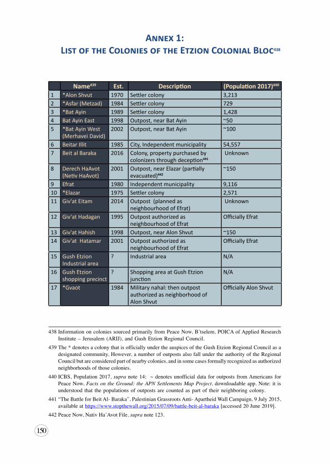
150
Annex 1: List of the Colonies of the Etzion Colonial Bloc438
439, 440, 441, 442
Name439 Est. Description (Population 2017)440
1 *Alon Shvut 1970 Settler colony 3,2132 *Asfar (Metzad) 1984 Settler colony 7293 *Bat Ayin 1989 Settler colony 1,4284 Bat Ayin East 1998 Outpost, near Bat Ayin ~505 *Bat Ayin West
(Merhavei David)2002 Outpost, near Bat Ayin ~100
6 Beitar Illit 1985 City, Independent municipality 54,5577 Beit al Baraka 2016 Colony, property purchased by
colonizers through deception441 Unknown
8 Derech HaAvot (Netiv HaAvot)
2001 Outpost, near Elazar (partially evacuated)442
~150
9 Efrat 1980 Independent municipality 9,11610 *Elazar 1975 Settler colony 2,57111 Giv'at Eitam 2014 Outpost (planned as
neighbourhood of Efrat) Unknown
12 Giv'at Hadagan 1995 Outpost authorized as neighbourhood of Efrat
Officially Efrat
13 Giv'at Hahish 1998 Outpost, near Alon Shvut ~15014 Giv'at Hatamar 2001 Outpost authorized as
neighbourhood of EfratOfficially Efrat
15 Gush Etzion Industrial area
? Industrial area N/A
16 Gush Etzion shopping precinct
? Shopping area at Gush Etzion junction
N/A
17 *Gvaot 1984 Military nahal: then outpost authorized as neighborhood of Alon Shvut
Officially Alon Shvut
438InformationoncoloniessourcedprimarilyfromPeaceNow,B’tselem,POICAofAppliedResearchInstitute–Jerusalem(ARIJ),andGushEtzionRegionalCouncil.
439The*denotesacolonythatisofficiallyundertheauspicesoftheGushEtzionRegionalCouncilasadesignatedcommunity.However,anumberofoutpostsalsofallundertheauthorityoftheRegionalCouncilbutareconsideredpartofnearbycolonies,andinsomecasesformallyrecognizedasauthorizedneighborhoodsofthosecolonies.
440ICBS,Population2017,supranote14; ~denotesunofficialdata foroutposts fromAmericans forPeaceNow,Facts on the Ground: the APN Settlements Map Project,downloadableapp.Note:it isunderstood that thepopulationsofoutpostsarecountedaspartof theirneighboringcolony.
441“TheBattleforBeitAl-Baraka”,PalestinianGrassrootsAnti-ApartheidWallCampaign,9July2015,availableathttps://www.stopthewall.org/2015/07/09/battle-beit-al-baraka[accessed20June2019].
442PeaceNow,NativHa’AvotFile,supranote123.
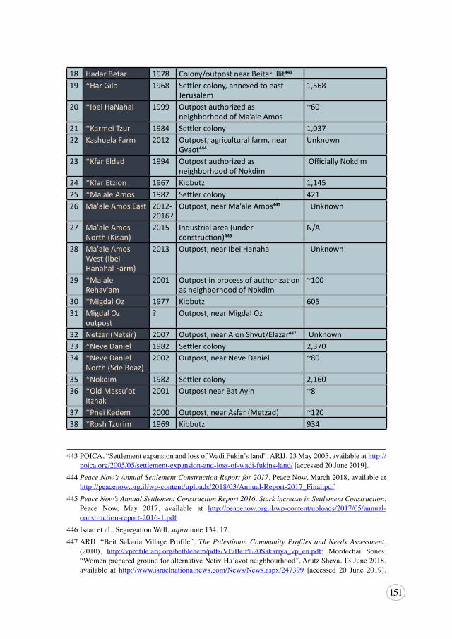
151
443, 444, 445, 446, 447
18 Hadar Betar 1978 Colony/outpost near Beitar Illit443
19 *Har Gilo 1968 Settler colony, annexed to east Jerusalem
1,568
20 *Ibei HaNahal 1999 Outpost authorized as neighborhood of Ma’ale Amos
~60
21 *Karmei Tzur 1984 Settler colony 1,03722 Kashuela Farm 2012 Outpost, agricultural farm, near
Gvaot444Unknown
23 *Kfar Eldad 1994 Outpost authorized as neighborhood of Nokdim
Officially Nokdim
24 *Kfar Etzion 1967 Kibbutz 1,14525 *Ma'ale Amos 1982 Settler colony 42126 Ma'ale Amos East 2012-
2016?Outpost, near Ma'ale Amos445 Unknown
27 Ma'ale Amos North (Kisan)
2015 Industrial area (under construction)446
N/A
28 Ma'ale Amos West (Ibei Hanahal Farm)
2013 Outpost, near Ibei Hanahal Unknown
29 *Ma'ale Rehav'am
2001 Outpost in process of authorization as neighborhood of Nokdim
~100
30 *Migdal Oz 1977 Kibbutz 60531 Migdal Oz
outpost? Outpost, near Migdal Oz
32 Netzer (Netsir) 2007 Outpost, near Alon Shvut/Elazar447 Unknown33 *Neve Daniel 1982 Settler colony 2,37034 *Neve Daniel
North (Sde Boaz)2002 Outpost, near Neve Daniel ~80
35 *Nokdim 1982 Settler colony 2,16036 *Old Massu'ot
Itzhak2001 Outpost near Bat Ayin ~8
37 *Pnei Kedem 2000 Outpost, near Asfar (Metzad) ~12038 *Rosh Tzurim 1969 Kibbutz 934
443POICA,“SettlementexpansionandlossofWadiFukin’sland”,ARIJ,23May2005,availableathttp://poica.org/2005/05/settlement-expansion-and-loss-of-wadi-fukins-land/[accessed20June2019].
444 Peace Now’s Annual Settlement Construction Report for 2017,PeaceNow,March2018,availableathttp://peacenow.org.il/wp-content/uploads/2018/03/Annual-Report-2017_Final.pdf
445 Peace Now’s Annual Settlement Construction Report 2016:Stark increase in Settlement Construction,Peace Now, May 2017, available at http://peacenow.org.il/wp-content/uploads/2017/05/annual-construction-report-2016-1.pdf
446Isaacetal.,SegregationWall,supranote134,17.447ARIJ, “Beit SakariaVillage Profile”,The Palestinian Community Profiles and Needs Assessment,
(2010), http://vprofile.arij.org/bethlehem/pdfs/VP/Beit%20Sakariya_vp_en.pdf; Mordechai Sones,“WomenpreparedgroundforalternativeNetivHa’avotneighbourhood”,ArutzSheva,13June2018,available at http://www.israelnationalnews.com/News/News.aspx/247399 [accessed 20 June 2019].
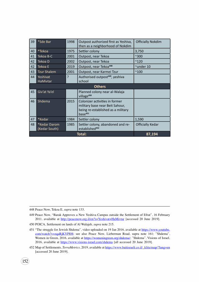
152
448, 449, 450, 451, 452
39 *Sde Bar 1998 Outpost authorized first as Yeshiva, then as a neighborhood of Nokdim
Officially Nokdim
40 *Tekoa 1975 Settler colony 3,75041 Tekoa B-C 2001 Outpost, near Tekoa ~30042 Tekoa D 2002 Outpost, near Tekoa ~12042 Tekoa E 2019 Outpost, near Tekoa448 ~under 1043 Tzur Shalem 2001 Outpost, near Karmei Tzur ~10044 Yeshivat
HaMivtar? Authorised outpost449, yeshiva
schoolOthers
45 Giv’at Ya’el Planned colony near al-Walaja village450
46 Shdema 2015 Colonizer activities in former military base near Beit Sahour, being re-established as a military base451
47 *Kedar 1984 Settler colony 1,59048 *Kedar Darom
(Kedar South)1985 Settler colony, abandoned and re-
established452 Officially Kedar
Total: 87,194
448PeaceNow,TekoaE,supranote133.449PeaceNow,“BarakApprovesaNewYeshivaCampusoutsidetheSettlementofEfrat”,16February
2011, available at http://peacenow.org.il/en?s=Yeshivat+HaMivtar [accessed 20 June 2019].450POICA,SettlementonlandsofAlWalajeh,supranote215.451“ThestruggleforJewishShdema”,videouploadedon19Jan2016,availableathttps://www.youtube.
com/watch?v=zqaRjKYPl08; see also Peace Now, Lieberman Road, supra note 161; ”Shdema”,WomeninGreen,2016,availableathttps://womeningreen.org/shdema/;”Shdema”,VisionsofIsrael,2016,availableathttps://www.visions-israel.com/shdema [all accessed20 June2019].
452MapofSettlements,TerraMetrics,2019,availableathttps://www.baitisraeli.co.il/_klita/map/?lang=en[accessed20June2019].

153
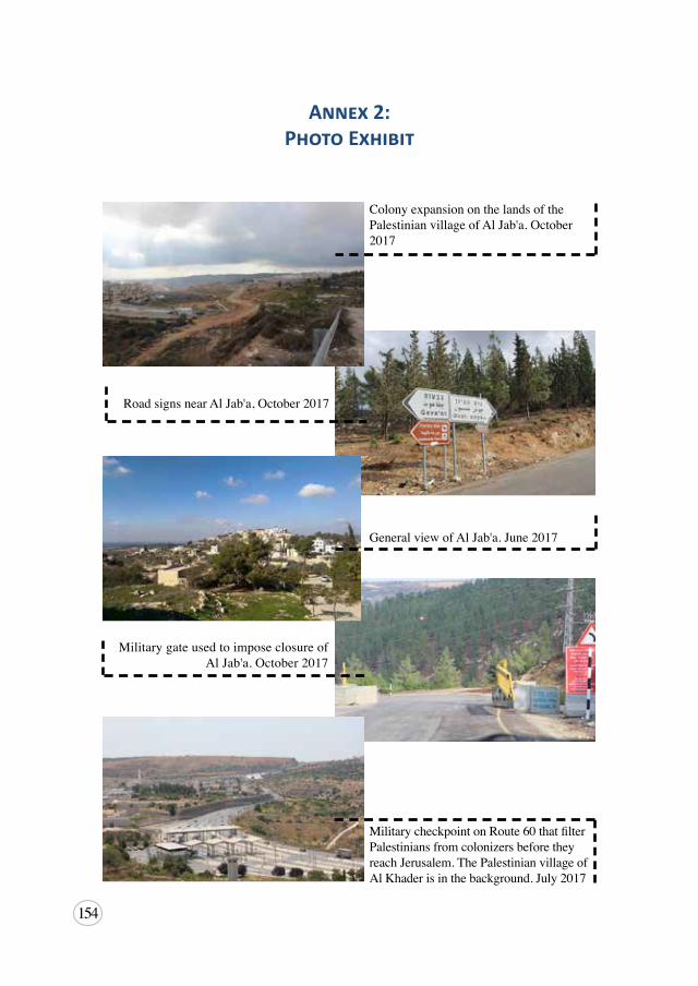
154
Annex 2: Photo Exhibit
ColonyexpansiononthelandsofthePalestinianvillageofAlJab'a.October2017
RoadsignsnearAlJab'a,October2017
GeneralviewofAlJab'a.June2017
MilitarygateusedtoimposeclosureofAlJab'a.October2017
MilitarycheckpointonRoute60thatfilterPalestiniansfromcolonizersbeforetheyreachJerusalem.ThePalestinianvillageofAlKhaderisinthebackground.July2017
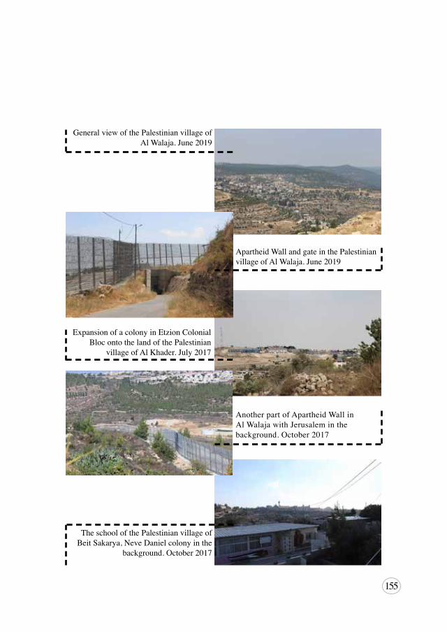
155
GeneralviewofthePalestinianvillageofAlWalaja.June2019
ApartheidWallandgateinthePalestinianvillageofAlWalaja.June2019
ExpansionofacolonyinEtzionColonialBlocontothelandofthePalestinian
villageofAlKhader.July2017
AnotherpartofApartheidWallinAlWalajawithJerusaleminthebackground.October2017
TheschoolofthePalestinianvillageofBeitSakarya,NeveDanielcolonyinthe
background.October2017
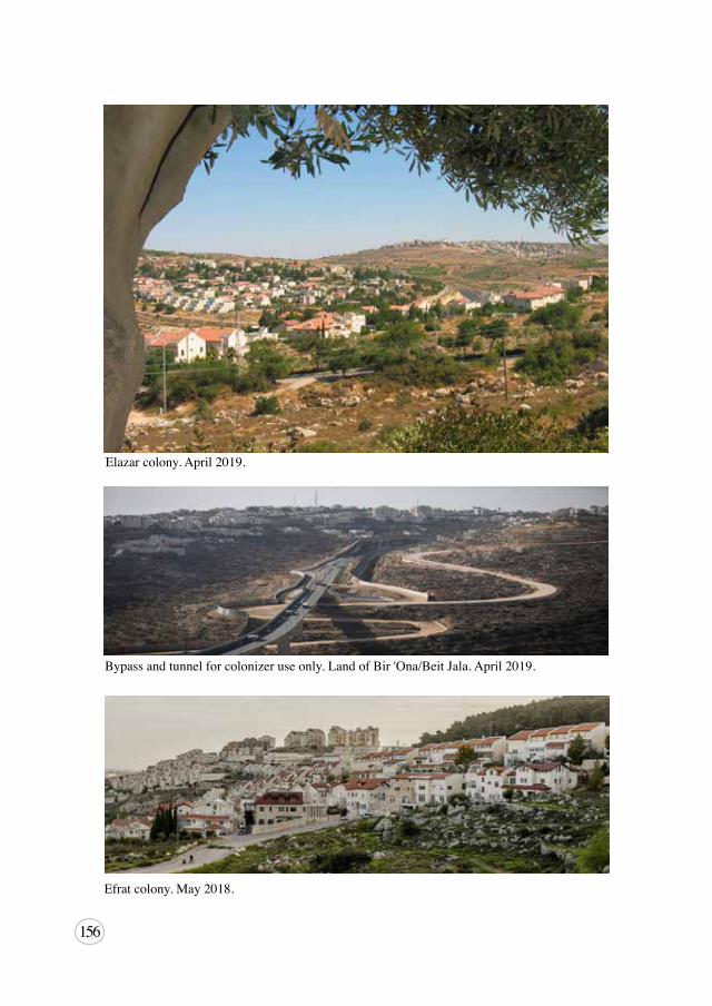
156
Bypassandtunnelforcolonizeruseonly.LandofBir'Ona/BeitJala.April2019.
Efratcolony.May2018.
Elazarcolony.April2019.
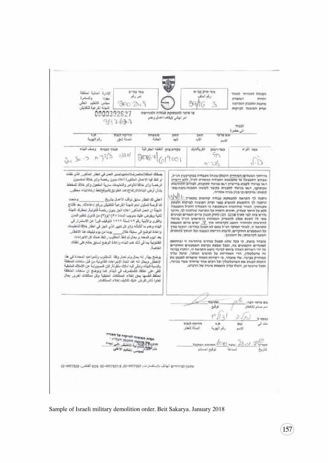
157
SampleofIsraelimilitarydemolitionorder.BeitSakarya.January2018
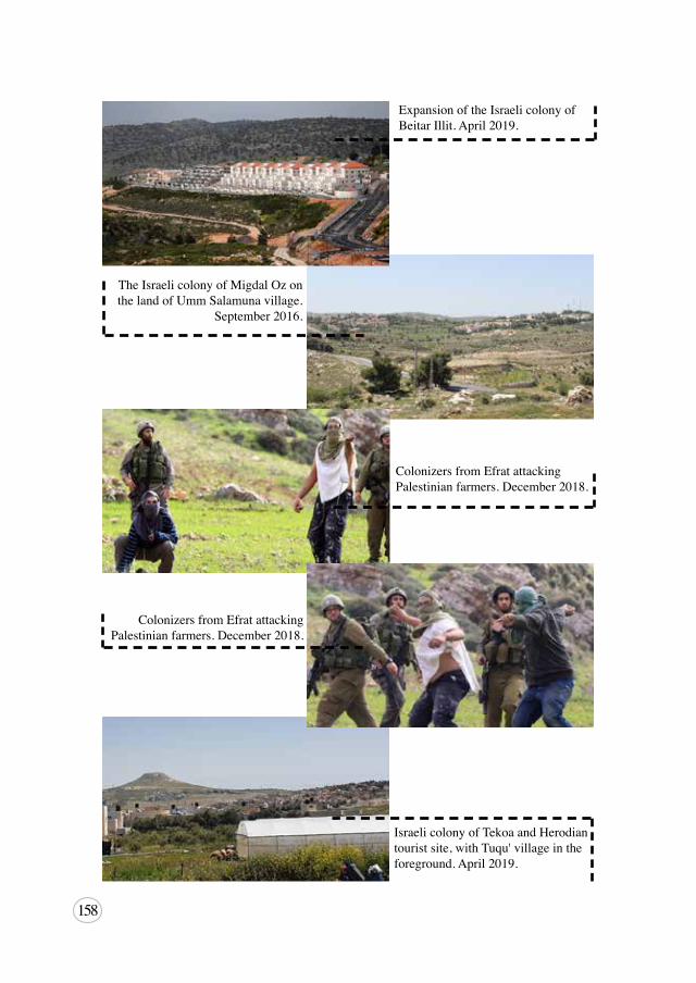
158
ExpansionoftheIsraelicolonyofBeitarIllit.April2019.
TheIsraelicolonyofMigdalOzonthelandofUmmSalamunavillage.
September2016.
ColonizersfromEfratattackingPalestinianfarmers.December2018.
ColonizersfromEfratattackingPalestinianfarmers.December2018.
IsraelicolonyofTekoaandHerodiantouristsite,withTuqu'villageintheforeground.April2019.
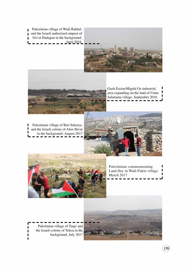
159
PalestinianvillageofWadiRahhal,andtheIsraeliauthorizedoutpostofGiv'atHadaganinthebackground.
April2018.
GushEtzion/MigdalOzindustrialareaexpandingonthelandofUmmSalamunavillage.September2016.
PalestinianvillageofBeitSakarya,andtheIsraelicolonyofAlonShvut
inthebackground.August2017
PalestinianscommemoratingLandDayinWadiFukinvillage.March2017
PalestinianvillageofTuqu'andtheIsraelicolonyofTekoainthe
background,July2017
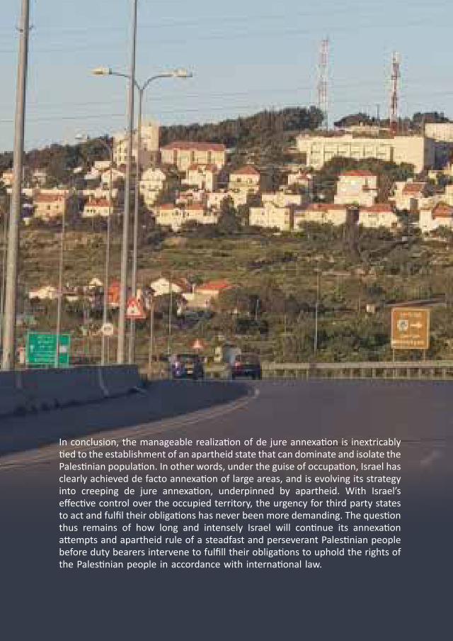
BADIL
for Palestinian Residency and Refugee RightsResource Center
بـديـــــل
ملصـادر حقـــوق املواطنـة والـالجئيـن
املركز الفلسطيني
Etzion Colonial BloC
July 2019
IsraelI annexatIon:
In conclusion, the manageable realization of de jure annexation is inextricably tied to the establishment of an apartheid state that can dominate and isolate the Palestinian population. In other words, under the guise of occupation, Israel has clearly achieved de facto annexation of large areas, and is evolving its strategy into creeping de jure annexation, underpinned by apartheid. With Israel’s effective control over the occupied territory, the urgency for third party states to act and fulfil their obligations has never been more demanding. The question thus remains of how long and intensely Israel will continue its annexation attempts and apartheid rule of a steadfast and perseverant Palestinian people before duty bearers intervene to fulfill their obligations to uphold the rights of the Palestinian people in accordance with international law.
The Case of
BADIL has consultative status with UN ECOSOC
BADIL
Israeli Annexation: The Case of Etzion Colonial Bloc