Embed Size (px)
Citation preview
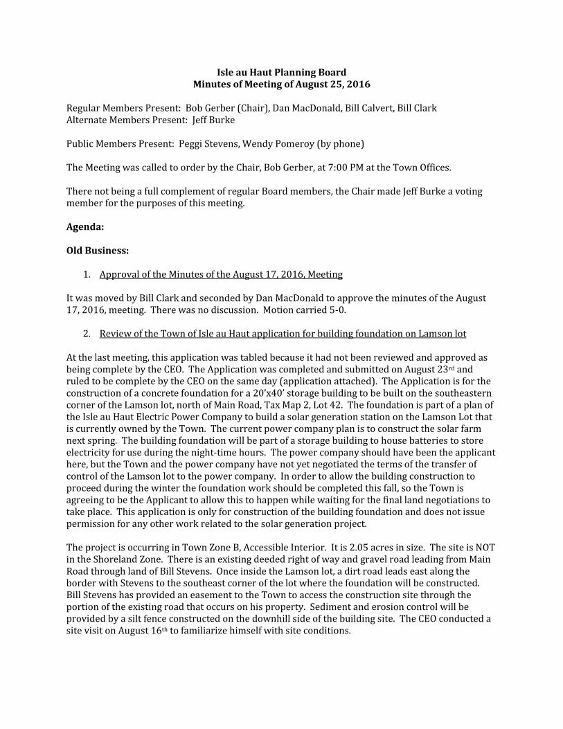
Isle au Haut Planning Board Minutes of Meeting of August 25, 2016
Regular Members Present: Bob Gerber (Chair), Dan MacDonald, Bill Calvert, Bill Clark Alternate Members Present: Jeff Burke
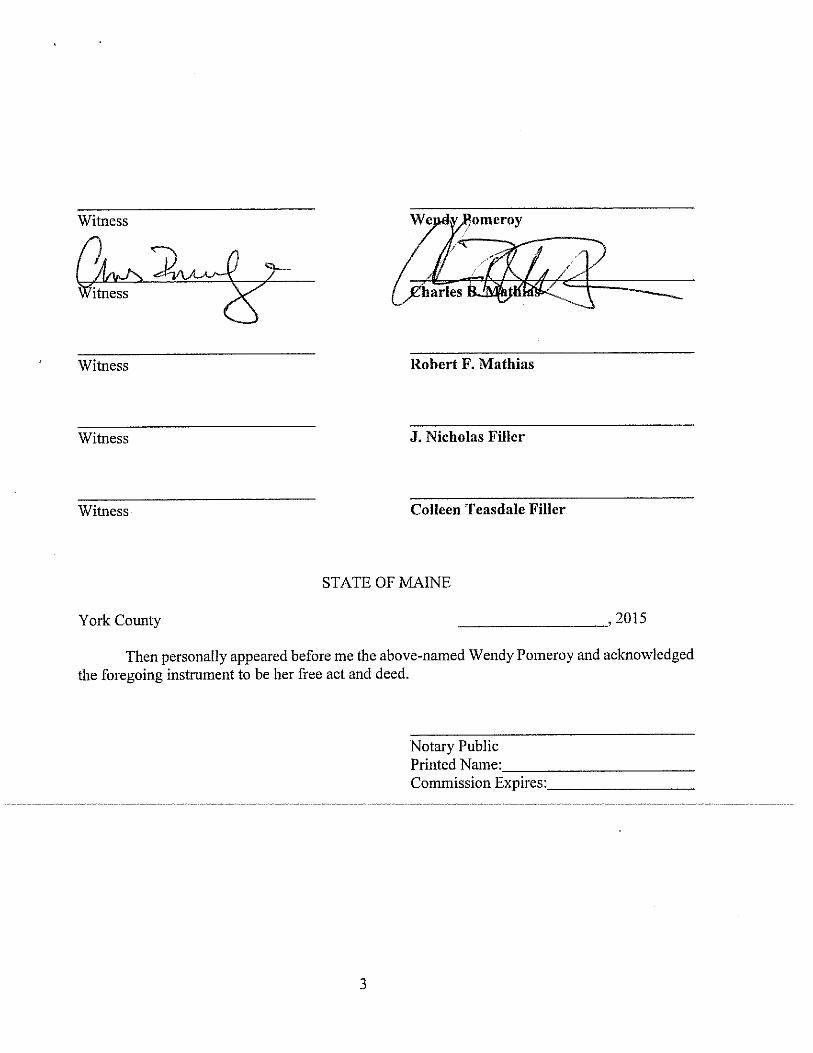
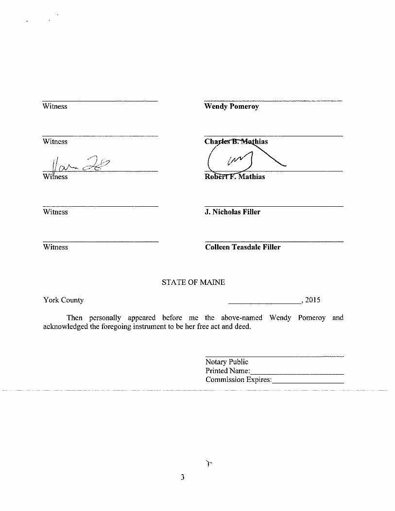
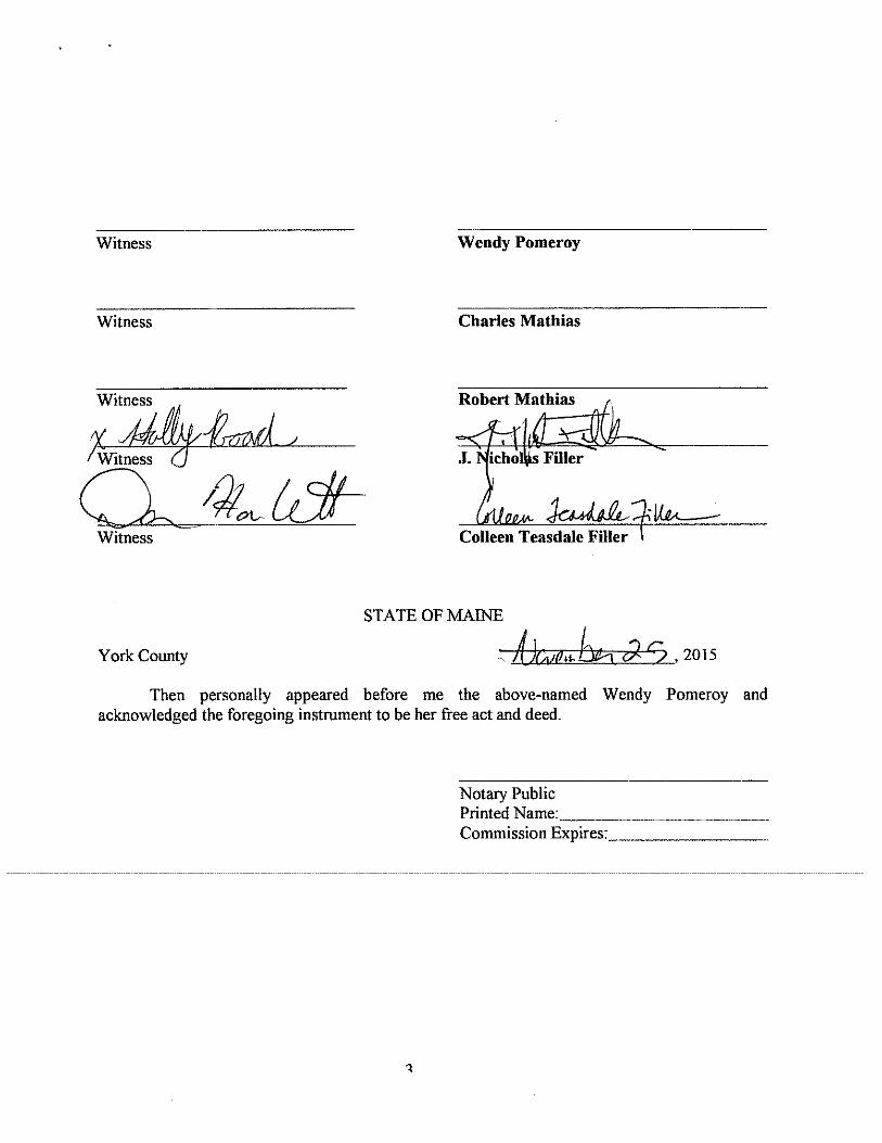
Public Members Present: Peggi Stevens, Wendy Pomeroy (by phone)
The Meeting was called to order by the Chair, Bob Gerber, at 7:00 PM at the Town Offices.
There not being a full complement of regular Board members, the Chair made Jeff Burke a voting member for the purposes of this meeting.
Agenda:
Old Business:
1. Approval of the Minutes of the August 17, 2016, Meeting
It was moved by Bill Clark and seconded by Dan MacDonald to approve the minutes of the August17, 2016, meeting. There was no discussion. Motion carried 5-0.
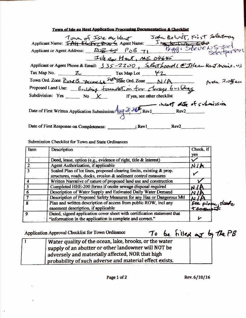
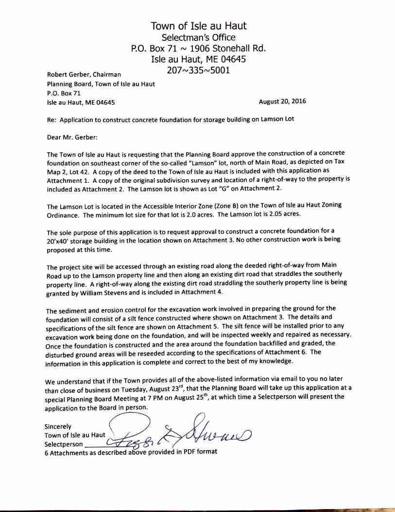
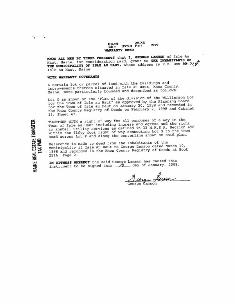
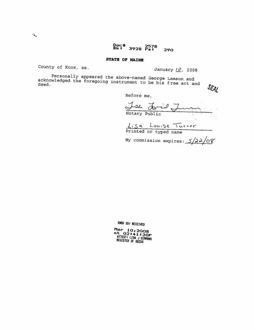
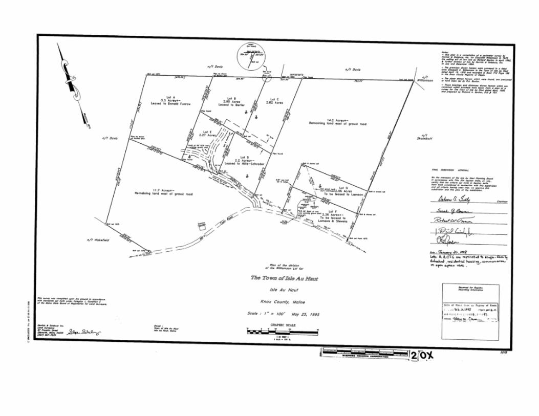
2. Review of the Town of Isle au Haut application for building foundation on Lamson lot
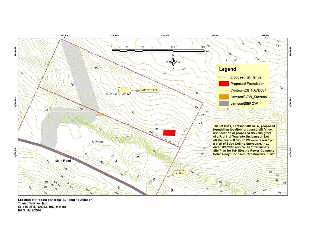
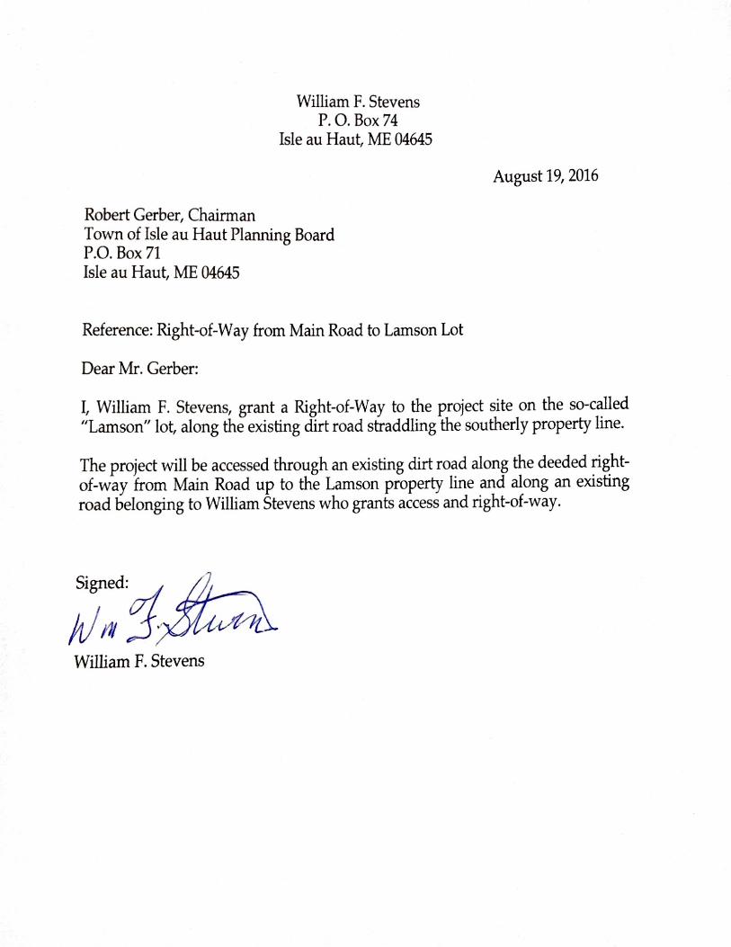
At the last meeting, this application was tabled because it had not been reviewed and approved asbeing complete by the CEO. The Application was completed and submitted on August 23rd andruled to be complete by the CEO on the same day (application attached). The Application is for theconstruction of a concrete foundation for a 20’x40’ storage building to be built on the southeastern corner of the Lamson lot, north of Main Road, Tax Map 2, Lot 42. The foundation is part of a plan of the Isle au Haut Electric Power Company to build a solar generation station on the Lamson Lot thatis currently owned by the Town. The current power company plan is to construct the solar farm next spring. The building foundation will be part of a storage building to house batteries to storeelectricity for use during the night-time hours. The power company should have been the applicanthere, but the Town and the power company have not yet negotiated the terms of the transfer of control of the Lamson lot to the power company. In order to allow the building construction toproceed during the winter the foundation work should be completed this fall, so the Town is agreeing to be the Applicant to allow this to happen while waiting for the final land negotiations totake place. This application is only for construction of the building foundation and does not issuepermission for any other work related to the solar generation project.
The project is occurring in Town Zone B, Accessible Interior. It is 2.05 acres in size. The site is NOT in the Shoreland Zone. There is an existing deeded right of way and gravel road leading from Main Road through land of Bill Stevens. Once inside the Lamson lot, a dirt road leads east along the border with Stevens to the southeast corner of the lot where the foundation will be constructed. Bill Stevens has provided an easement to the Town to access the construction site through the portion of the existing road that occurs on his property. Sediment and erosion control will be provided by a silt fence constructed on the downhill side of the building site. The CEO conducted a site visit on August 16th to familiarize himself with site conditions.
RGG, 8-26-16 Page 2 Planning Bd Minutes of 8-25-16
There was a brief discussion of the issue that the Town might have some liability if a person or property were injured in the construction of the project, since the project is on Town land. Peggi Stevens, present to represent the interests of the Town through the Selectmen, said that certificates of insurance would be required from all contractors doing the work.
The Board went quickly through the Town criteria for approval and noted that all the requirements would be met. The water quality criterion would be met by the use of the sediment and erosion control measures proposed by the Applicant.
Bill Clark moved and Jeff Burke seconded to approve the application. The vote was 5-0 in favor. The Chair said he would issue the formal permit letter the next day.
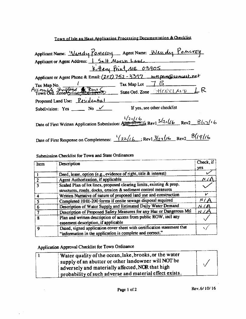
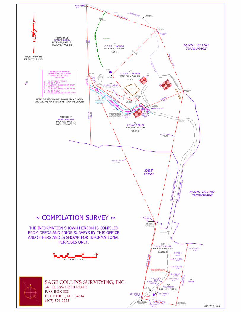
3. Review of application from Pomeroy for Birch Point driveway
This was another application (attached) submitted the day before the last Planning Board meeting which the CEO had not had time to review and approve as complete. It was tabled to be taken up at this special meeting, provided the CEO found the application to be complete. The CEO issued a letter confirming that the Application was complete on August 19th.
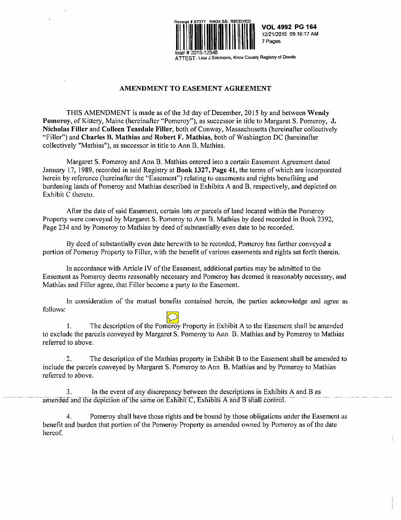
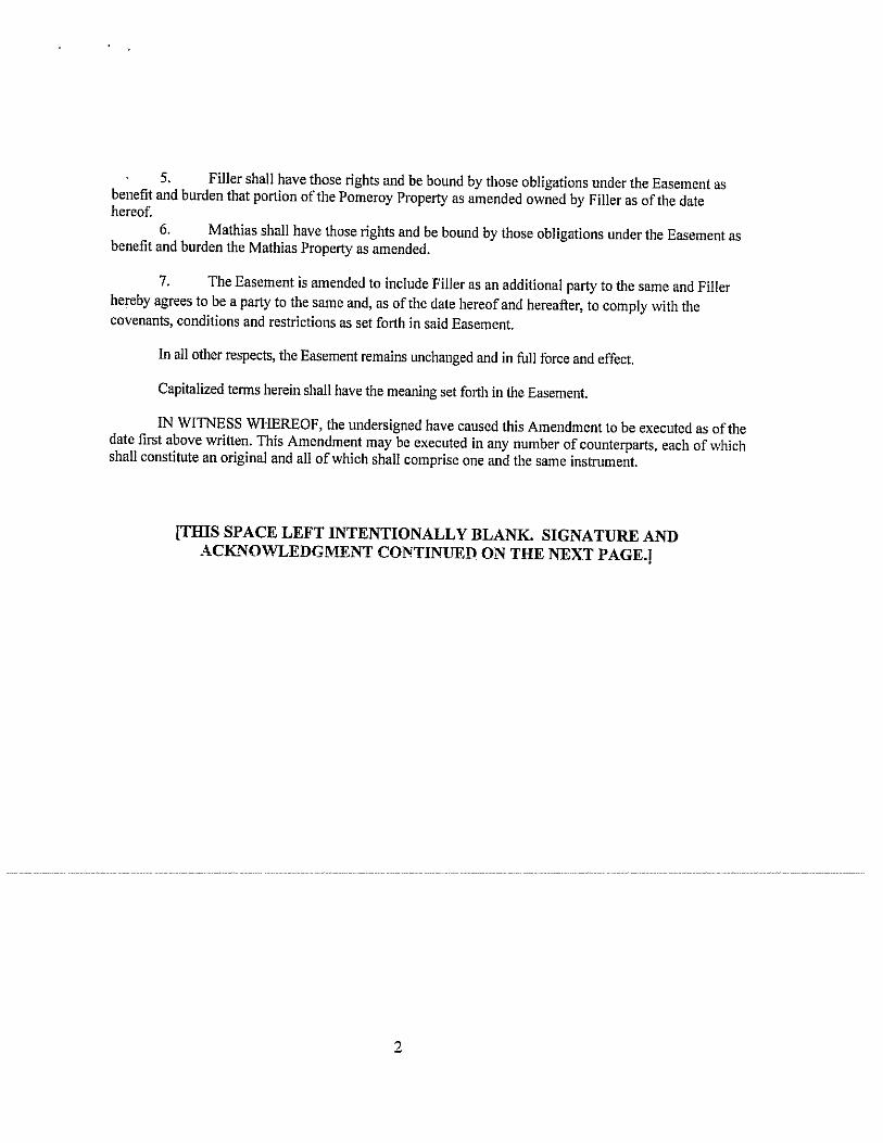
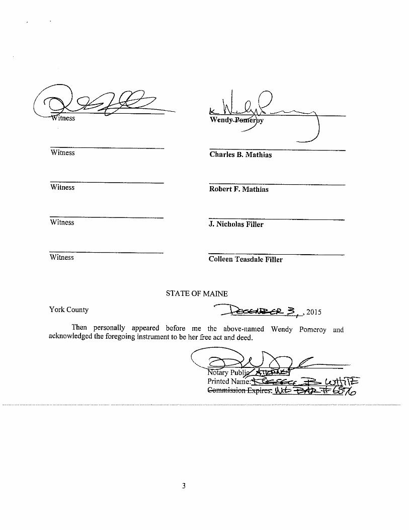
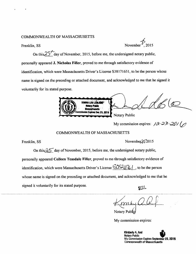
This application was initiated last December with Matthew Skolnikoff acting as Agent for the Ownerat the time. Wendy Pomeroy, owner of the property that is the subject of the application, rescindedthe Agent letter in the spring of 2016. Because no evidence of “right, title and interest,” nor any sediment and erosion control details were submitted with the original application, it was neverdeclared complete. Different missing pieces of the required application materials were submittedover time. Once the site deeds and easements were reviewed by the CEO, he discovered that there was a provision in the deed to Filler that the new Pomeroy driveway segment that would cross hisproperty required his permission and a survey plan to locate where that segment would go on hisproperty. That plan was not delivered by the surveyor until the day before the last meeting. The CEO conducted a site visit on June 30th with Wendy Pomeroy and the Fillers to familiarize himself with the proposed driveway route.
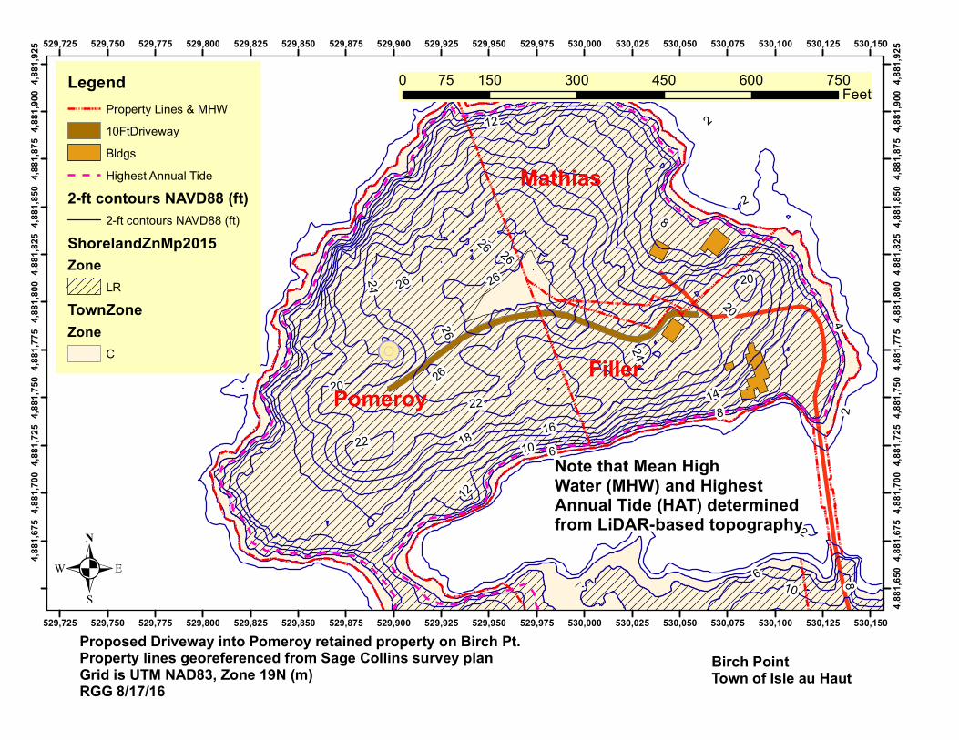
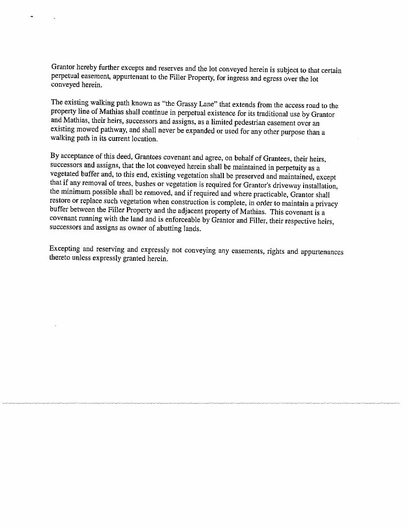
The project consists of vegetative clearing and earthwork construction to create a driveway thatwill be 595 feet long, starting at the driveway going to Mathias on Birch Point. Only the driveway construction is being requested under this application. The driveway follows through a portion ofMathias property, then westward across the northwestern portion of Filler’s property, then into the land retained by Wendy Pomeroy. It generally lies on or close to high ground. Much of theproposed route is through an area of blowdowns. The driveway goes through Town Zone C,Accessible Shoreland, and through Shoreland Zone Limited Residential. The property is roughly 7.6acres above MHW and has about 2360’ of frontage on saltwater. The purpose of the driveway is toserve an eventual house to be constructed.
It was noted by Bill Clark that the delay in approving the project had a beneficial outcome in that the driveway location was moved from its initial position proposed by Skolnikoff to a position that was approved by all concerned property owners.
The Chair noted that a condition would be added to the permit that would require proper management of the brush and slash in order to reduce the risk of fire. Wendy Pomeroy, speaking on the conference line, said that she was pleased that this project would finally be done as it would help to clear up some of the blowdowns on the property.

RGG, 8-26-16 Page 3 Planning Bd Minutes of 8-25-16
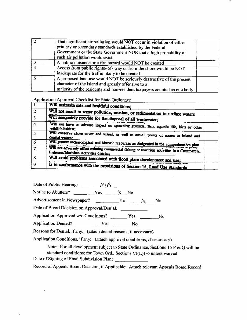
The Board went down through the approval criteria for both the Town and Shoreland Zoning Ordinance. Criterion 1 of the Town Ordinance would be met by the implementation of the proposed erosion and sediment control plan. Criterion 2 of the Town Ordinance was NA. Criterion 3 of the Town Ordinance would be met by placing a condition on the permit requiring removal/disposal of brush and slash. Criterion 4 was met via the evidence of the deeds and easements. Criterion 5 would be met because clearing of the blowdowns would be an improvement in aesthetic conditions. With respect to the Shoreland Ordinance, criteria 3, 7, and 8 are NA. Criterion 1 safety criterion would be met through the fire control condition. Criterion 4 would be met through the sediment and erosion control plan implementation. Criterion 5 would be met because this project will not impinge on the 75-foot zone and generally would not be visible from outside of Birch Point. Condition 6 is met because there are no identified archaeological resources within the project limits. Criterion 9 will be met by adherence to the cutting and erosion and sediment control standards.
It was moved by Dan MacDonald and seconded by Bill Calvert to approve the Application with the fire control condition. The vote was 5-0 to approve. The Chair said he would issue the permit letter the next day.
_________________________________________________ There being no other business to come before this special meeting of the Board, it was moved by Jeff Burke and seconded by Dan MacDonald to adjourn the meeting at 7:30 PM
Respectfully submitted,
Robert G. Gerber, Chair
MAINE EROSION AND SEDIMENT CONTROL BMP revised 10/2012 B-1 SEDIMENT BARRIERS
PURPOSE & APPLICATIONS A sediment barrier is a temporary barrier installed across or at the toe of a slope. Sediment barriers may consist of filter fence, straw or hay bales, a berm of erosion control mix, or other filter materials. Its purpose is to intercept and retain small amounts of sediment from disturbed or unprotected areas. The sediment barrier is used where: • Sedimentation can pollute or degrade adjacent wetland and/or watercourses. • Sedimentation will reduce the capacity of storm drainage systems or adversely affect
adjacent areas. • The contributing drainage area is less than 1/4 acre per 100 ft of barrier length, the maximum
length of slope above the barrier is 100 feet, and the maximum gradient behind the barrier is 50 percent (2:1). If the slope length is greater, other measures such as diversions may be necessary to reduce the slope length.
• Sediment barriers shall not be used in areas of concentrated flows. Under no circumstances should hay bale or erosion control mix barriers be constructed in live streams or in swales where there is the possibility of a washout.
CONSIDERATIONS • Sediment barriers are effective only if installed and maintained properly. • Silt fencing generally is a better filter than hay bale barriers. • If there is evidence of end flow on properly installed barriers, extend barriers uphill or
consider replacing them with temporary check dams. • Straw or hay bales should only be used as a temporary barrier for no longer than 60 days. • Silt fences (synthetic filter) can be used for 60 days or longer depending on ultraviolet stability
and manufacturer's recommendations. • Sediment barriers should be installed prior to any soil disturbance of the contributing drainage
area above them.
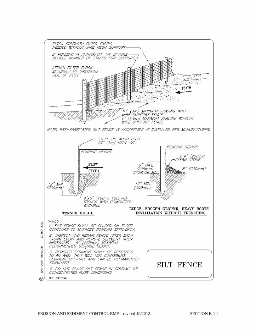
SPECIFICATIONS Filter Fences This sediment barrier utilizes synthetic filter fabrics. It is designed for situations in which only sheet or overland flows are expected. Generally pre-manufactured synthetic silt fencing with posts attached is used. See the detail drawing located at the back of this section for the proper installation of silt fences. • The filter fabric shall be a pervious sheet of propylene, nylon, polyester or ethylene yarn and
shall be certified by the manufacturer or supplier. • The filter fabric shall contain ultraviolet ray inhibitors and stabilizers to provide a minimum of
6 months of expected usable construction life at a temperature range of 0 degrees F to 120 degrees F.
• Posts for silt fences shall be either 4-inch diameter wood or 1.33 pounds per linear foot steel with a minimum length of 5 feet. Steel posts shall have projections for fastening wire to them.
• The height of a silt fence should not exceed 36 inches as higher fences may impound volumes of water sufficient to cause failure of the structure.
• The filter fabric shall be purchased in a continuous roll cut to the length of the barrier to avoid the use of joints. When joints are necessary, filter cloth shall be spliced together only at support post, with a minimum 6-inch overlap, and securely sealed.
• Post spacing shall not exceed 6 feet.
EROSION AND SEDIMENT CONTROL BMP – revised 10/2012 SECTION B-1-2
• A trench shall be excavated approximately 4 inches wide and 4 inches deep along the line of posts and upgradient from the barrier.
• The standard strength of filter fabric shall be stapled or wired to the post, and 8 inches of the fabric shall be extended into the trench. The fabric shall not extend more than 36 inches above the original ground surface. Filter fabric shall not be stapled to existing trees.
• The trench shall be backfilled and the soil compacted over the filter fabric. • Silt fences shall be removed when they have served their useful purpose, but not before the
upslope areas have been permanently stabilized.
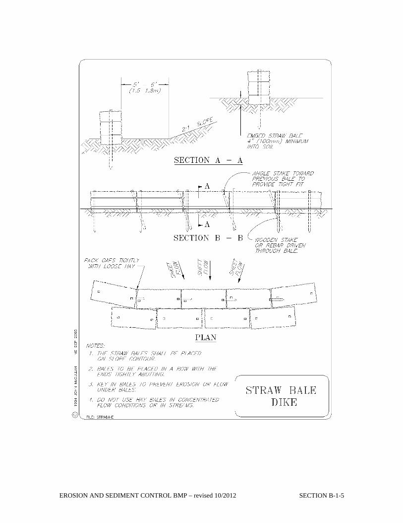
Straw/Hay Bales See the detail drawing located at the back of this section for the proper installation of hay bales. • Bales shall be placed in a single row, lengthwise on the contour, with ends of adjacent bales
tightly abutting one another. • All bales shall be either wire-bound or string-tied. Bales shall be installed so that bindings are
oriented around the sides, parallel to the ground surface to prevent deterioration of the bindings.
• The barrier shall be entrenched and backfilled. A trench shall be excavated the width of a bale and the length of the proposed barrier to a minimum depth of 4 inches.
• After the bales are staked and chinked, the excavated soil shall be backfilled against the barrier. Backfill soil shall conform to the ground level on the downhill side and shall be build up to 4 inches against the uphill side of the barrier. Ideally, bales should be placed 10 feet away from the toe of slope.
• At least two stakes or rebars driven through the bale shall securely anchor each bale. The first stake in each bale shall be driven toward the previously laid bale to force the bales together. Stakes or re-bars shall be driven deep enough into the ground to securely anchor the bales.
• The gaps between bales shall be chinked (filled by wedging) with hay to prevent water from escaping between the bales.
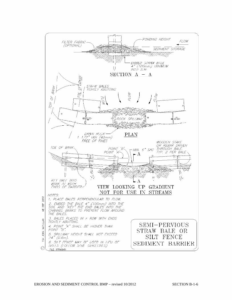
Problems with Straw or Hay Bale Barriers There are three major reasons why straw bale barriers are not as effective as hoped they would be: • When improperly placed and installed (such as staking the bales directly to the ground with
no soil seal or entrenchment), hay bales allow undercutting and end flow. • Inadequate maintenance. • Inspection shall be frequent and repair or replacement shall be made promptly as needed.
Bale barriers shall be removed when they have served their usefulness, but not before the up-slope areas have been permanently stabilized.
Erosion Control Mix Berms Erosion control mix can be manufactured on or off the project site. It must consist primarily of organic material, separated at the point of generation, and may include: shredded bark, stump grindings, or acceptable manufactured products. Wood and bark chips, ground construction debris or reprocessed wood products will not be acceptable as the organic component of the mix. Composition Erosion control mix shall contain a well-graded mixture of particle sizes and may contain rocks less than 4” in diameter. Erosion control mix must be free of refuse, physical contaminants, and material toxic to plant growth. The mix composition shall meet the following standards: • The organic matter content shall be between 50 and 100%, dry weight basis. • Particle size by weight shall be 100 % passing a 6“screen and a minimum of 70 %, maximum
of 85%, passing a 0.75” screen. • The organic portion needs to be fibrous and elongated. • Large portions of silts, clays or fine sands are not acceptable in the mix. • Soluble salts content shall be < 4.0 mmhos/cm. • The pH should fall between 5.0 and 8.0.
EROSION AND SEDIMENT CONTROL BMP – revised 10/2012 SECTION B-1-3
Installation • The barrier must be placed along a relatively level contour. It may be necessary to cut tall
grasses or woody vegetation to avoid creating voids and bridges that would enable fines to wash under the barrier through the grass blades or plant stems.
• On slopes less than 5 % or at the bottom of steeper slopes (<2:1) up to 20 feet long, the barrier must be a minimum of 12” high, as measured on the uphill side of the barrier, and a minimum of two feet wide. On longer or steeper slopes, the barrier should be wider to accommodate the additional runoff.
• Frozen ground, outcrops of bedrock and very rooted forested areas are locations where berms of erosion control mix are most practical and effective.
• Other BMPs should be used at low points of concentrated runoff, below culvert outlet aprons, around catch basins and closed storm systems, and at the bottom of steep perimeter slopes that are more than 50 feet from top to bottom (i.e., a large up gradient contributing watershed).
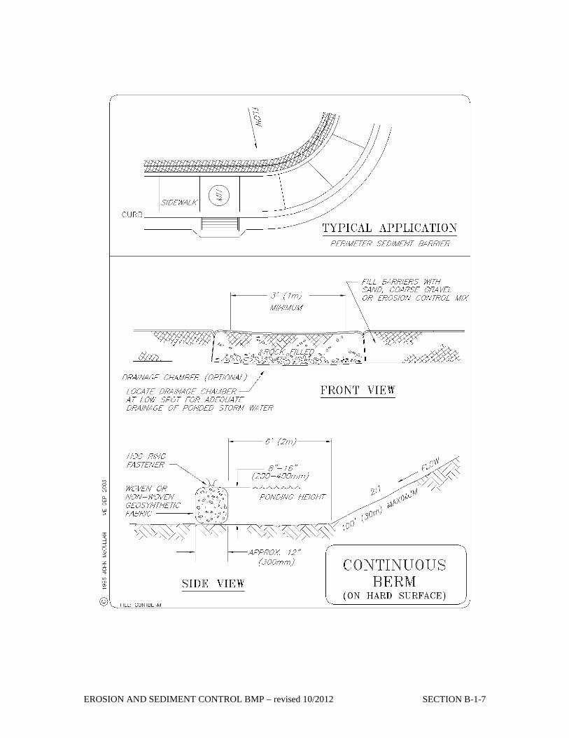
Continuous Contained Berms A new product, the filter sock can be an effective sediment barrier as it adds containment and stability to a berm of erosion control mix. The organic mix is placed in the synthetic tubular netting and performs as a sturdy sediment barrier (a vehicle may drive over it without ill effect). It works well in areas where trenching is not feasible such as over frozen ground or over pavement. A continuous contained berm of erosion control mix may be effective when placed in waterways such as ditches and swales or in area of concentrated water flow as the netting prevents the movement and displacement of the organic material. See the detail drawing located at the back of this section for the proper installation of continuous contained berms. Seeds may be added to the organic filler material and can permanently stabilize a shallow slope. The containment will provide stability while vegetation is rooting through the netting.
MAINTENANCE • Hay bale barriers, silt fences and filter berms shall be inspected immediately after each
rainfall and at least daily during prolonged rainfall. They shall be repaired immediately if there are any signs of erosion or sedimentation below them. If there are signs of undercutting at the center or the edges of the barrier, or impounding of large volumes of water behind them, sediment barriers shall be replaced with a temporary check dam.
• Should the fabric on a silt fence or filter barrier decompose or become ineffective prior to the end of the expected usable life and the barrier still is necessary, the fabric shall be replaced promptly.
• Sediment deposits should be removed after each storm event. They must be removed when deposits reach approximately one-half the height of the barrier.
• Filter berms should be reshaped as needed. • Any sediment deposits remaining in place after the silt fence or filter barrier is no longer
required should be dressed to conform to the existing grade, prepared and seeded.
EROSION AND SEDIMENT CONTROL BMP – revised 10/2012 SECTION B-1-4
EROSION AND SEDIMENT CONTROL BMP – revised 10/2012 SECTION B-1-5
EROSION AND SEDIMENT CONTROL BMP – revised 10/2012 SECTION B-1-6
EROSION AND SEDIMENT CONTROL BMP – revised 10/2012 SECTION B-1-7
Vegetation
48
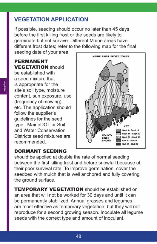
VEGETATION APPLICATIONIf possible, seeding should occur no later than 45 days before the first killing frost or the seeds are likely to germinate but not survive. Different Maine areas have different frost dates; refer to the following map for the final seeding date of your area.
PERMANENTVEGETATION should be established with a seed mixture that is appropriate for the site’s soil type, moisture content, sun exposure, use (frequency of mowing), etc. The application should follow the supplier’s guidelines for the seed type. MaineDOT or Soil and Water Conservation Districts seed mixtures are recommended.
DORMANTSEEDING should be applied at double the rate of normal seeding between the first killing frost and before snowfall because of their poor survival rate. To improve germination, cover the seedbed with mulch that is well anchored and fully covering the ground surface.
TEMPORARYVEGETATION should be established on an area that will not be worked for 30 days and until it can be permanently stabilized. Annual grasses and legumes are most effective as temporary vegetation; but they will not reproduce for a second growing season. Inoculate all legume seeds with the correct type and amount of inoculant.
Vege
tatio
n
49
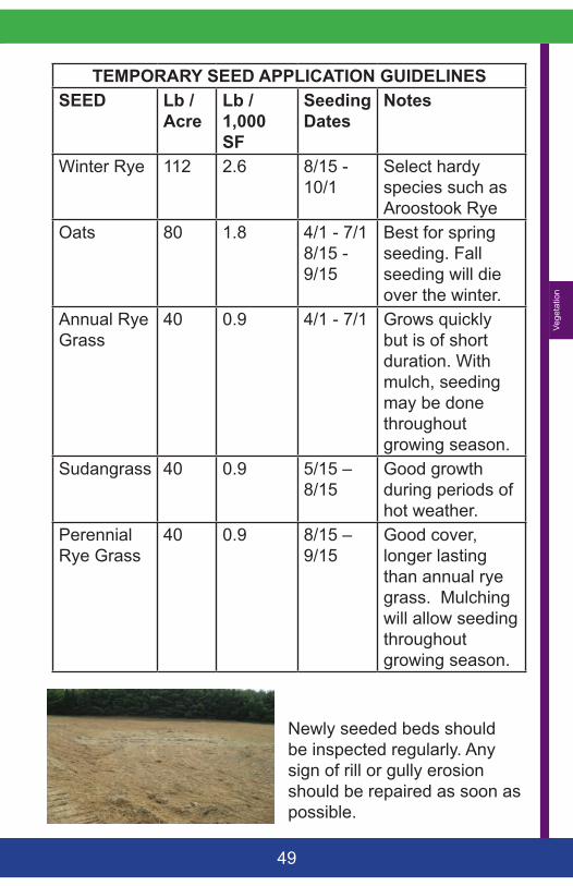
TEMPORARY SEED APPLICATION GUIDELINESSEED Lb /
AcreLb / 1,000 SF
Seeding Dates
Notes
Winter Rye 112 2.6 8/15 - 10/1
Select hardy species such as Aroostook Rye
Oats 80 1.8 4/1 - 7/1 8/15 - 9/15
Best for spring seeding. Fall seeding will die over the winter.
Annual Rye Grass
40 0.9 4/1 - 7/1 Grows quickly but is of short duration. With mulch, seeding may be done throughout growing season.
Sudangrass 40 0.9 5/15 – 8/15
Good growth during periods of hot weather.
Perennial Rye Grass
40 0.9 8/15 – 9/15
Good cover, longer lasting than annual rye grass. Mulching will allow seeding throughout growing season.
Newly seeded beds should be inspected regularly. Any sign of rill or gully erosion should be repaired as soon as possible.

Wendy Pomeroy
1 Salt Marsh Ln. Kittery Point ME 03905 August 16, 2016 Planning Board, Isle au Haut, Thank you for hearing the application for a new driveway on Birch Point. This extends from the existing driveway to my potential building lot for one residence. Enclosed is the Documentation & Checklist; Survey by Licensed Maine Surveyor, Sage Collins; and Erosion Control Plan. All information in the application is complete and correct to the best of my knowledge.
Best Regards,
Wendy Pomeroy
&)
2
4
6
8
12
10
14
1618
2022
24 26
26
2
8
26
22
2
12
26
2
26
86
20
24
10
2026
529,725
529,725
529,750
529,750
529,775
529,775
529,800
529,800
529,825
529,825
529,850
529,850
529,875
529,875
529,900
529,900
529,925
529,925
529,950
529,950
529,975
529,975
530,000
530,000
530,025
530,025
530,050
530,050
530,075
530,075
530,100
530,100
530,125
530,125
530,150
530,150
4,881
,650
4,881
,675
4,881
,675
4,881
,700
4,881
,700
4,881
,725
4,881
,725
4,881
,750
4,881
,750
4,881
,775
4,881
,775
4,881
,800
4,881
,800
4,881
,825
4,881
,825
4,881
,850
4,881
,850
4,881
,875
4,881
,875
4,881
,900
4,881
,900
4,881
,925
4,881
,925
LegendProperty Lines & MHW10FtDrivewayBldgsHighest Annual Tide
2-ft contours NAVD88 (ft)2-ft contours NAVD88 (ft)
ShorelandZnMp2015Zone
LRTownZoneZone
C
.
0 150 300 450 600 75075Feet
Proposed Driveway into Pomeroy retained property on Birch Pt.Property lines georeferenced from Sage Collins survey planGrid is UTM NAD83, Zone 19N (m)RGG 8/17/16
Birch PointTown of Isle au Haut
Note that Mean HighWater (MHW) and HighestAnnual Tide (HAT) determinedfrom LiDAR-based topography
Pomeroy
Mathias
Filler
DRILL HOLE INLEDGE FOUND
APPROXIMATEHIGH WATERLINE
13'± BELOWAHW
DRILL HOLE INLEDGE FOUND
AT AHW
HOUSE
GARAGE
DUGWELL
FENCED-IN AREA
1" BRASSPIPE FOUND
3/4" BRASSPIPE FOUND
GARAGE
STAKED PROPOSEDSEPTIC AREA
1" BRASSPIPE FOUND
WATERTANK
2.5 ACRES ± (OA)
S 45° 00' W19.8'
N 46° 10' W 61.4'
S 66° 59' W
176.2'
GRANITE RETAINING WALL
FOO
TPATH
DRIVE
S 54° 03' E 177.8'
(SET 1999)
(SET 1999)
(SET 1999)
N 67° 10' W 160.5'
N 36° 22' W
60.0'
N 1° 52' W
292.0'
BOULDER
EDG
E OF CLEARED
AREA
N/FMARGARET S. POMEROY
BOOK 1327, PAGE 32
N 66° 59' E 9.8'
362'± ALO
NG AHW
325'± ALONG AHW
CLEARED AREA
BOOK 1327, PAGE 26
BOOK 2392, PAGE 234
N 55° 25' E49.4'
S 34° 39' E22.4'
6'± TOAHW
DUGWELL
SMALLBEACH
GIANTSPLIT BOULDER
IRON BOLTIN LEDGE
HOUSE
SHED
DECK
TALL IRON BOLTIN BOULDER
IRON ROD INLEDGE OR ROCK
CAU
SEW
AY
BRIDGE
DRIVE
B
WENDY M. POMEROY
SMALLISLAND
SALTMARSH
SALTPOND
BIRCHPOINT
f'lyANN MATHIAS
305'±
0.6 Acres ±
FILLER
26
2626
26
24
24
22
22
20
20
18
16
14
12
12
12
10
10
8
PENOBSCOTBAY
BURNT ISLANDTHOROFARE
0 100 200
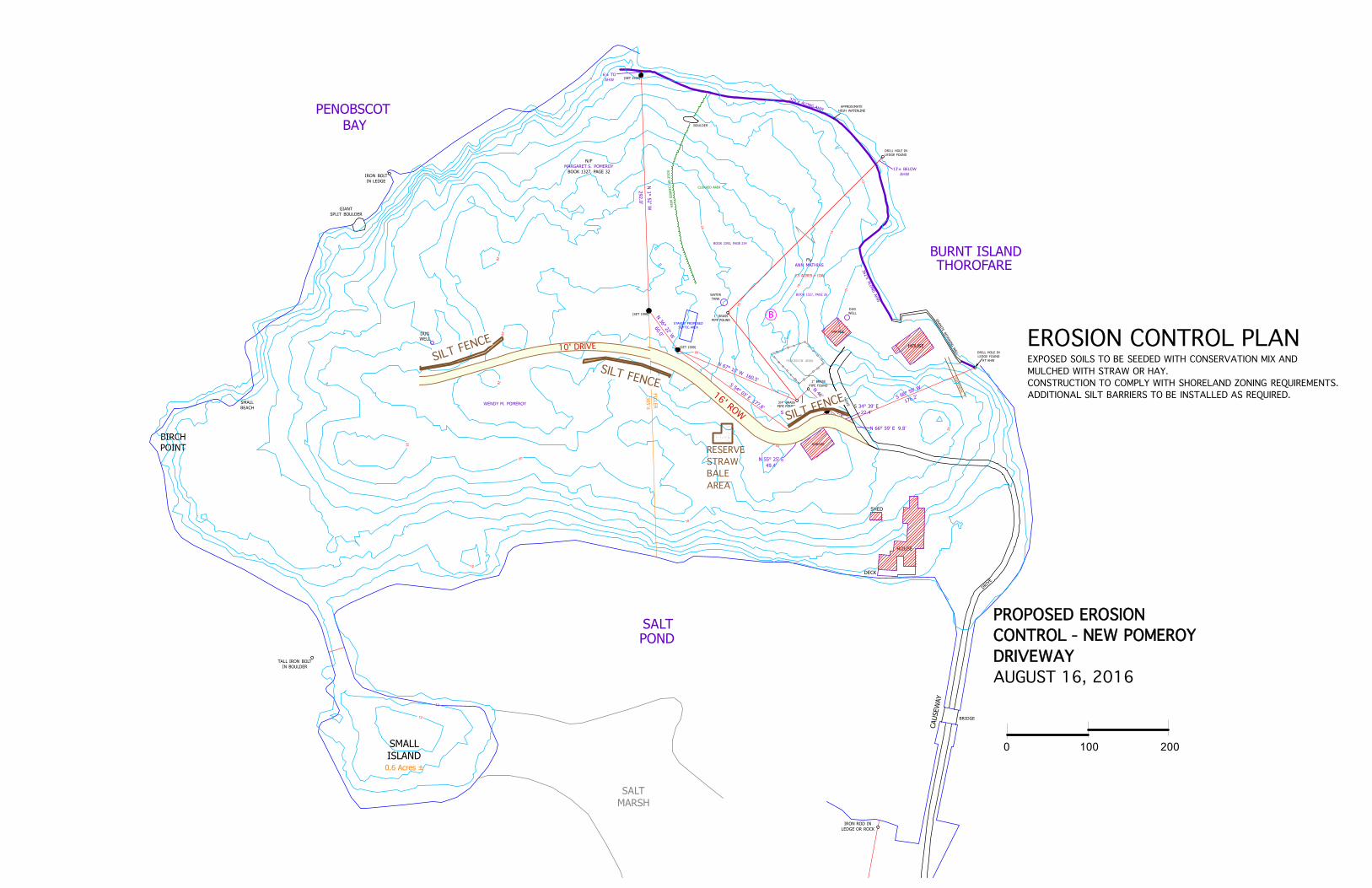
PROPOSED EROSION CONTROL - NEW POMEROY DRIVEWAYAUGUST 16, 2016
16' ROW
EROSION CONTROL PLANEXPOSED SOILS TO BE SEEDED WITH CONSERVATION MIX ANDMULCHED WITH STRAW OR HAY.CONSTRUCTION TO COMPLY WITH SHORELAND ZONING REQUIREMENTS.ADDITIONAL SILT BARRIERS TO BE INSTALLED AS REQUIRED.
RESERVESTRAW BALE AREA
SILT FENCE
SILT FENCE
SILT FENCE
10' DRIVE
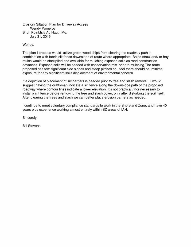
Erosion/ Siltation Plan for Driveway Access Wendy Pomeroy Birch Point,Isle Au Haut , Me. July 31, 2016
Wendy,
The plan I propose would utilize green wood chips from clearing the roadway path in combination with fabric silt fence downslope of route where appropriate. Baled straw and/ or hay mulch would be stockpiled and available for mulching exposed soils as road construction advances. Exposed soils will be seeded with conservation mix prior to mulching.The route proposed has few significant side slopes and steep pitches so I feel there should be minimal exposure for any significant soils displacement of environmental concern.
If a depiction of placement of silt barriers is needed prior to tree and slash removal , I would suggest having the draftsman indicate a silt fence along the downslope path of the proposed roadway where contour lines indicate a lower elevation. It's not practical / nor necessary to install a silt fence before removing the tree and slash cover, only after disturbing the soil itself.After clearing the trees and slash we can better place erosion barriers as needed.
I continue to meet voluntary compliance standards to work in the Shoreland Zone, and have 40 years plus experience working almost entirely within SZ areas of IAH.
Sincerely,
Bill Stevens
Sed
imen
t C
ontro
ls
19
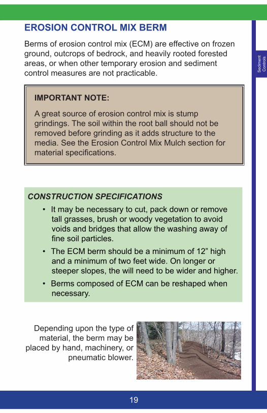
EROSION CONTROL MIX BERM Berms of erosion control mix (ECM) are effective on frozen ground, outcrops of bedrock, and heavily rooted forested areas, or when other temporary erosion and sediment control measures are not practicable.
IMPORTANT NOTE:
A great source of erosion control mix is stump grindings. The soil within the root ball should not be removed before grinding as it adds structure to the media. See the Erosion Control Mix Mulch section for material specifications.
CONSTRUCTION SPECIFICATIONS• It may be necessary to cut, pack down or remove
tall grasses, brush or woody vegetation to avoid voids and bridges that allow the washing away of fine soil particles.
• The ECM berm should be a minimum of 12” high and a minimum of two feet wide. On longer or steeper slopes, the will need to be wider and higher.
• Berms composed of ECM can be reshaped when necessary.
Depending upon the type of material, the berm may be
placed by hand, machinery, or pneumatic blower.
Sed
imen
t C
ontro
ls
17
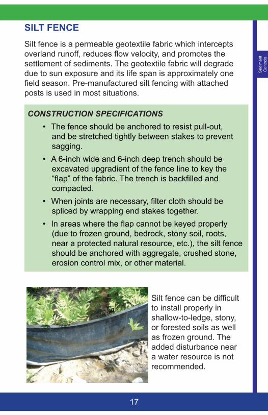
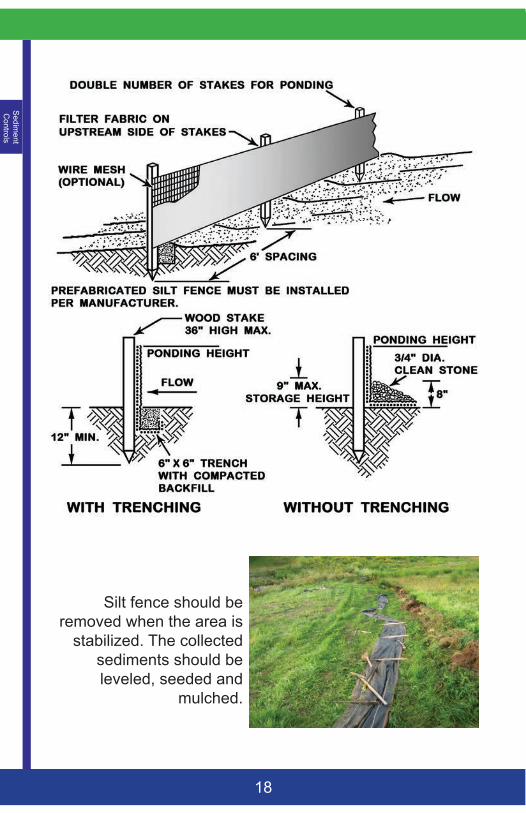
SILT FENCE Silt fence is a permeable geotextile fabric which intercepts overland runoff, reduces flow velocity, and promotes the settlement of sediments. The geotextile fabric will degrade due to sun exposure and its life span is approximately one field season. Pre-manufactured silt fencing with attached posts is used in most situations.
CONSTRUCTION SPECIFICATIONS• The fence should be anchored to resist pull-out,
and be stretched tightly between stakes to prevent sagging.
• A 6-inch wide and 6-inch deep trench should be excavated upgradient of the fence line to key the “flap” of the fabric. The trench is backfilled and compacted.
• When joints are necessary, filter cloth should be spliced by wrapping end stakes together.
• In areas where the flap cannot be keyed properly (due to frozen ground, bedrock, stony soil, roots, near a protected natural resource, etc.), the silt fence should be anchored with aggregate, crushed stone, erosion control mix, or other material.
Silt fence can be difficult to install properly in shallow-to-ledge, stony, or forested soils as well as frozen ground. The added disturbance near a water resource is not recommended.
Sedim
ent C
ontrols
18
Silt fence should be removed when the area is
stabilized. The collected sediments should be leveled, seeded and
mulched.
8/17/2016 Roundcube Webmail :: Re: Survey of Pomeroy Drive
https://emailmg.ipage.com/roundcube/?_task=mail&_safe=0&_uid=299&_mbox=INBOX&_action=print&_extwin=1 1/1
Subject Re: Survey of Pomeroy DriveFrom Nicholas Filler <[email protected]>To Pomeroy wendy <[email protected]>
Cc
Colleen Filler <[email protected]>, Mathias Charlie<[email protected]>, Mathias Charlie <[email protected]>,Mathias Rob <[email protected]>, Bob Gerber<[email protected]>, Deane Rykerson<[email protected]>
Date 20160816 19:16
Wendy,
This plan and the easement location set forth on it look fine to me.
Hope all is well with you and your family.
All the best,
Nick
Nick Filler
455 Mathews RoadConway, MA. 01341
Home: 413‐369‐4748Cell: 413‐522‐4011
On Aug 16, 2016, at 5:14 PM, Pomeroy wendy <[email protected]> wrote:
Dear Neighbors,We have waited patiently for this survey from Sage Collins. It has arrived the day before the PlanningBoard meeting. This may be brought before the Board if everything looks OK. If not, there will beanother meeting some time in September. I would like this to go before the Board tomorrow.
Could you take a look at this and send a quick note of approval to Bob Gerber? Bob Gerber’s email is above.With Appreciation,Wendy
<Pomeroy ‐ IAH 8‐16‐16.pdf>
Wendy M PomeroyOne Salt Marsh LaneKittery Point, ME 03905
Landscape Design and ConsultationGarden Structures
8/17/2016 Roundcube Webmail :: Re: Survey of Pomeroy Drive
https://emailmg.ipage.com/roundcube/?_task=mail&_safe=0&_uid=307&_mbox=INBOX&_action=print&_extwin=1 1/2
Subject Re: Survey of Pomeroy DriveFrom Robert Mathias <[email protected]>To Pomeroy wendy <[email protected]>
CcMathias Charlie <[email protected]>, Bob Gerber<[email protected]>, Sarah Mathias<[email protected]>
Date 20160817 11:42
Wendy/Bob
This looks great. Sarah and I are fully supporĕve
Robert MathiasCEO | North AmericaOgilvy Public Relations PresidentOgilvy WashingtonT 202 729 4000ogilvy.com
From: Pomeroy wendy <[email protected]>Sent: Tuesday, August 16, 2016 5:14:40 PMTo: Filler Nick; Colleen FillerCc: Mathias Charlie; Mathias Charlie; Robert Mathias; Bob Gerber; Deane RykersonSubject: Survey of Pomeroy Drive Dear Neighbors,We have waited patiently for this survey from Sage Collins. It has arrived the day before the Planning Board meeting. This may be brought before the Board if everything looks OK. If not, there will be another meeting some time inSeptember. I would like this to go before the Board tomorrow.
Could you take a look at this and send a quick note of approval to Bob Gerber? Bob Gerber's email is above.With Appreciation,Wendy
Privileged/Confidential Information may be contained in this message. If you are not the addressee indicated in this message, youshould destroy this message. For more information on WPP's business ethical standards and corporate responsibility policies, please