Embed Size (px)
Citation preview
http://www.aprh.pt/rgci/pdf/rgci-283_Barcellos.pdf
DOI:10.5894/rgci283
Island beaches morphological and sedimentary short term variations – the case of SE Fernando de Noronha Island, South Atlantic, Brazil *
Variações sedimentológicas e morfológicas de curta prazo em praias insulares: o caso do SE da ilha de Fernando Noronha, Atlântico Sul, Brasil
Revista da Gestão Costeira Integrada 11(4):471-478 (2011)Journal of Integrated Coastal Zone Management 11(4):471-478 (2011)
R.L. Barcellos @, 1, C. Coelho-Júnior 2, S.R.R.M. Lins 1; M.S. Silva 1, P.B. Camargo 3, P.E.P.F. Travassos 4
* Submission: May 1, 2011; Evaluation: June 13, 2011; Reception of revised manuscript: October 2, 2011; Accepted: December 4, 2011; Available on-line: December 19, 2011
@ - Corresponding author: [email protected] - Universidade Federal de Pernambuco (UFPE), Departamento de Oceanografia, 50.740-550, Recife (PE), Brazil2 - Universidade Federal de Pernambuco (UFPE), Instituro de Ciências Biológicas, Recife (PE), Brazil3 - Universidade de São Paulo, Centro de Energia Isotópica na Agricultura (CENA-USP), ESALQ Campus, Piracicaba (SP), 13.400-970, Brazil4 - Universidade Federal Rural de Pernambuco (UFRPE), Centro de Pesca e Aqüicultura, Recife, PE, Brasil
AbstrAct
The Fernando de Noronha archipelago is comprised of 21 volcanic islands (26km2) located in the south equatorial Atlantic (4°S/32°W), 540km from Recife, Pernambuco state, Brazil. This study evaluates the short term morphological variations, the distribution and characteristics of surface sediments from the tropical meso-tidal Sueste bay, beach, mangrove, lagoon and dune systems, located in the southern coast of the main island. Eight beach profiles and 80 surface sediment samples were collected in January, April, June and October of 2010. The research methods included grain-size, calcium carbonate, total, elemental and isotopic organic matter analysis and monitoring of two beach profiles. The collected samples are fine sandy (> 99% of sand in 87,5% of samples), well to moderately sorted and bioclastic, presenting high carbonate contents (> 94% in 52,5% of the samples). Despite the homogeneity of fine sandy bioclastic moderately sorted sedimentary properties, this morphodynamic study shows spatial and temporal differences between the sediments of the west and the east side of the Sueste beach, as well as in each compartment of the Sueste beach/bay system. Multitemporal topographic profiles of the beach reveal seasonal erosion/accretion due to oceanographic-climatic processes. They also show the strong silting process in course on the Sueste mangrove and lagoon. The main factor responsible for this modern deposition and the beach physiography, along with the distribution of sediments in the Sueste beach shoreface and backshore, is the SE wind (Southern Hemisphere Trade Wind). This pattern accumulates sediments in the beach west side, occasionally removed for the Sueste bay when the mangrove lagoon breaks in the huge rain events, carrying fresh water and sediments to the foreshore.
Keywords: oceanic island biogenic sands, beach profiles, erosion/accretion/silting.
Resumo
O arquipélago de Fernando de Noronha é composto por 21 ilhas vulcânicas (26km2), localizadas na região equatorial do Atlântico sul (4°S/32°W) a 540km de Recife, estado de Pernambuco, Brasil. Este estudo avalia as variações morfológicas sazonais, a distribuição e as características dos sedimentos superficiais do sistema praial do Sueste (praia, mangue, laguna, dunas e baía), localizada na costa sul da ilha
Barcellos et al.Revista de Gestão Costeira Integrada / Journal of Integrated Coastal Zone Management 11(4):471-478 (2011)
- 472 -
1. INtrODUctION
The oceanic islands are unique environments which have received increasing attention from the scientific community due to their environmental importance (Clemente et al., 2009). Sandy beaches are common along many of the oceanic island coastlines, yet our understanding of the behavior of beach and near shore sediment systems on distinct scales of time remains limited. The environmental degradation of sandy beaches over the last decades has become widely recognized as a serious problem in oceanic islands (Rooney & Fletcher, 2005).
The beach environments represent a transition zone limiting sedimentary marine and continental processes, subjected to temporal variations due to sea level changes and sediment inputs (King, 1972). Beach morphodynamic studies are essential for understanding the processes of longshore currents sediment transportation and the spatial and temporal changes and evolution of these coastal sedimentary environments (Komar, 1998; Hoefel, 1998). Accordingly to studies by Short (1999) and Komar (1998), among others, the profile of a beach corresponds to an adjustment to seasonal cycles, with erosion occurring in more energetic conditions during the winter, and accretion conditions of a calmer sea during summer period.
Although the oceanic sand beaches occupy only a small portion of the total surface of the Earth, their frequent occurrence and use along the majority of tropical and temperate coasts of the world must be considered, assuming a substantial socio-economic and environmental importance in these regions (Stronge, 1994; Komar, 1998). On the other hand, oceanic island beach systems are very sensitive environments from a geo-ecosystem point of view, requiring specific planning measures for the management of these fragile ecosystems (Clark, 1977).
The preservation of the beaches and the protection of coastal properties require an understanding of nearshore processes: the motion of waves, the generation of nearshore currents, the movement of beach sediment, and the resulting variability in the beach morphology (Komar, 1998).
The last decades presented an increase in the number of works on calcareous beach systems in oceanic islands such
as Kench (1997), Dail et al. (2000), Norcross et al. (2002), Smith & Cheung (2002), Eversole & Fletcher (2003), Harney & Fletcher (2003) Rooney & Fletcher (2005) and Genz et al. (2007).
According to Goya & Tessler (2000), in Brazil, the beach system studies became more frequent in the 1990’s. Even considering the increase in beach morphology research, there are great gaps along the Brazilian continental coast, as well as in the Fernando de Noronha archipelago, in Pernambuco state. In this oceanic island, the studies are restricted to Valença et al. (2001) and Manso et al. (2011), for beaches located in the northern coast of the island (Mar de Dentro), in the aeolinites from Caieira Beach (Valença et al., 2005) and Pessenda et al. (2008) for the only study of marine sedimentology in the Sueste beach system (main island southern coast: Mar de Fora).
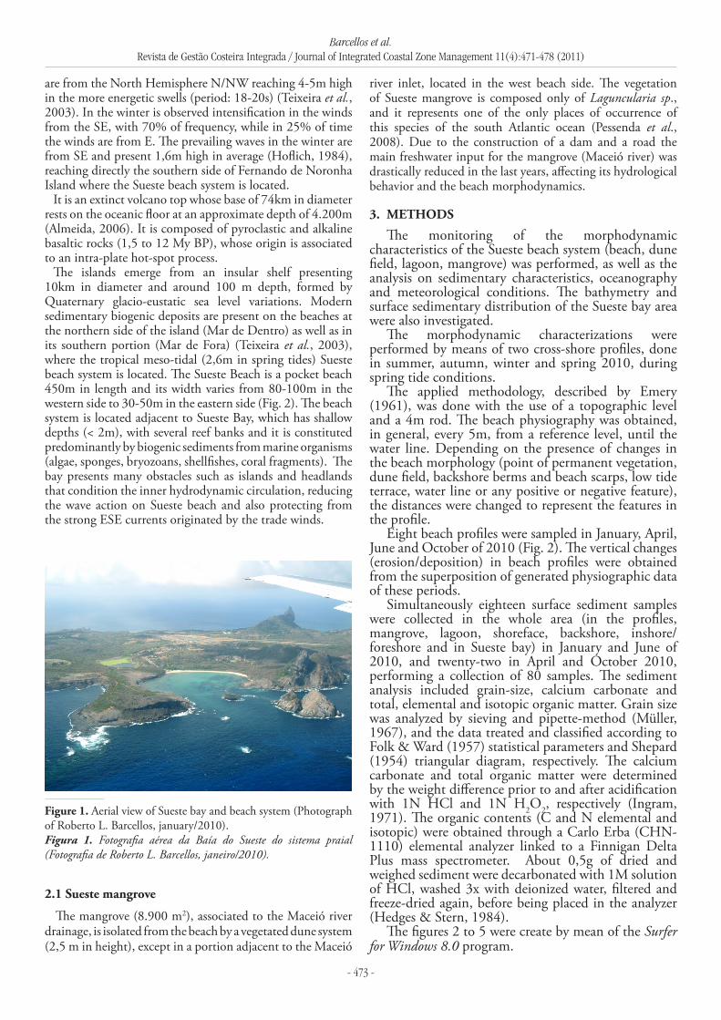
The aims of this article are to evaluate the short term morphological variations and the modern sedimentary processes, by means of the distribution, characteristics and geochemistry of surface sediments from the Sueste bay, beach, mangrove, lagoon and dune systems (Fig. 1).
2. stUDY sItE
The research site, the Fernando de Noronha archipelago, is located in the southwestern equatorial Atlantic ocean (4°S/32°W) (Fig. 2).The Fernando de Noronha archipelago is comprised of 21 volcanic islands (26km2) located in the south equatorial Atlantic (4°S/32°W), 540km from Recife, Pernambuco state, Brazil. The climate is tropical oceanic (Awi according to Köppen classification), with annual average temperature and precipitation of 25°C and 1.400mm, respectively, with great interannual variability. There are two well-marked seasons, being the humid period from March to July and the drier period from August to February (Teixeira et al., 2003).
Since Fernando de Noronha lies in the equatorial South Atlantic, the prevailing winds are from SE (Trade Winds) with average velocity of 6,6ms-1, exhibiting higher intensity from July to September (11ms-1) (Manso et al., 2011). During the summer, winds from the SE and E blow over 50% and 35% of the time, respectively (Hoflich, 1984). The prevailing waves
principal (Mar de Fora). O clima da ilha é tropical, estando sua zona costeira submetida a um regime de meso-marés. Oito perfis de praia e 80 amostras de sedimento superficial foram coletados em janeiro, abril, junho e outubro de 2010. Os métodos de investigação incluíram o tamanho de grão, carbonato de cálcio total, análise elementar e isotópica matéria orgânica e monitoramento de perfis de praia por meio da metodologia utilizando nível e estádia para nivelamento topográfico. As amostras coletadas apresentaram, em geral, textura areia fina (> 99% de areia em 87,5% das amostras), bem a moderadamente selecionados e de composição bioclástica, apresentando elevados teores de carbonato de cálcio (> 94% em 52,5% das amostras). Apesar da homogeneidade dos sedimentos compostos em geral de areia fina bioclástica moderadamente selecionada, o estudo morfodinâmico mostra diferenças espaciais e temporais entre os sedimentos das porções oeste e leste da praia do Sueste, assim como em cada compartimento do sistema praial do Sueste. Perfis 1 e 2 revelam um padrão sazonal de erosão e acreção devido aos condicionantes oceanográfico-climáticos de escala global e fatores fisiográficos locais. Eles também mostram o forte processo de assoreamento em curso no manguezal e laguna do Sueste. O vento SE (Ventos Alísios do Hemisfério Sul) parece ser o principal fator responsável pela deposição atual e distribuição de areias na face praial e pós-praia, e também pela fisiografia da praia. Este condicionamento tende a acumular sedimentos no lado oeste da praia, ocasionalmente removidos para a Baía do Sueste, quando ocorre o rompimento da laguna do mangue em eventos pluviais extremos, transferindo sedimentos para antepraia.
Palavras-chave: ilha oceânica, areias biogênicas, perfis praiais, erosão/acresção
Barcellos et al.Revista de Gestão Costeira Integrada / Journal of Integrated Coastal Zone Management 11(4):471-478 (2011)
- 473 -
are from the North Hemisphere N/NW reaching 4-5m high in the more energetic swells (period: 18-20s) (Teixeira et al., 2003). In the winter is observed intensification in the winds from the SE, with 70% of frequency, while in 25% of time the winds are from E. The prevailing waves in the winter are from SE and present 1,6m high in average (Hoflich, 1984), reaching directly the southern side of Fernando de Noronha Island where the Sueste beach system is located.
It is an extinct volcano top whose base of 74km in diameter rests on the oceanic floor at an approximate depth of 4.200m (Almeida, 2006). It is composed of pyroclastic and alkaline basaltic rocks (1,5 to 12 My BP), whose origin is associated to an intra-plate hot-spot process.
The islands emerge from an insular shelf presenting 10km in diameter and around 100 m depth, formed by Quaternary glacio-eustatic sea level variations. Modern sedimentary biogenic deposits are present on the beaches at the northern side of the island (Mar de Dentro) as well as in its southern portion (Mar de Fora) (Teixeira et al., 2003), where the tropical meso-tidal (2,6m in spring tides) Sueste beach system is located. The Sueste Beach is a pocket beach 450m in length and its width varies from 80-100m in the western side to 30-50m in the eastern side (Fig. 2). The beach system is located adjacent to Sueste Bay, which has shallow depths (< 2m), with several reef banks and it is constituted predominantly by biogenic sediments from marine organisms (algae, sponges, bryozoans, shellfishes, coral fragments). The bay presents many obstacles such as islands and headlands that condition the inner hydrodynamic circulation, reducing the wave action on Sueste beach and also protecting from the strong ESE currents originated by the trade winds.
river inlet, located in the west beach side. The vegetation of Sueste mangrove is composed only of Laguncularia sp., and it represents one of the only places of occurrence of this species of the south Atlantic ocean (Pessenda et al., 2008). Due to the construction of a dam and a road the main freshwater input for the mangrove (Maceió river) was drastically reduced in the last years, affecting its hydrological behavior and the beach morphodynamics.
3. MEtHODs
The monitoring of the morphodynamic characteristics of the Sueste beach system (beach, dune field, lagoon, mangrove) was performed, as well as the analysis on sedimentary characteristics, oceanography and meteorological conditions. The bathymetry and surface sedimentary distribution of the Sueste bay area were also investigated.
The morphodynamic characterizations were performed by means of two cross-shore profiles, done in summer, autumn, winter and spring 2010, during spring tide conditions.
The applied methodology, described by Emery (1961), was done with the use of a topographic level and a 4m rod. The beach physiography was obtained, in general, every 5m, from a reference level, until the water line. Depending on the presence of changes in the beach morphology (point of permanent vegetation, dune field, backshore berms and beach scarps, low tide terrace, water line or any positive or negative feature), the distances were changed to represent the features in the profile.
Eight beach profiles were sampled in January, April, June and October of 2010 (Fig. 2). The vertical changes (erosion/deposition) in beach profiles were obtained from the superposition of generated physiographic data of these periods.
Simultaneously eighteen surface sediment samples were collected in the whole area (in the profiles, mangrove, lagoon, shoreface, backshore, inshore/foreshore and in Sueste bay) in January and June of 2010, and twenty-two in April and October 2010, performing a collection of 80 samples. The sediment analysis included grain-size, calcium carbonate and total, elemental and isotopic organic matter. Grain size was analyzed by sieving and pipette-method (Müller, 1967), and the data treated and classified according to Folk & Ward (1957) statistical parameters and Shepard (1954) triangular diagram, respectively. The calcium carbonate and total organic matter were determined by the weight difference prior to and after acidification with 1N HCl and 1N H2O2, respectively (Ingram, 1971). The organic contents (C and N elemental and isotopic) were obtained through a Carlo Erba (CHN-1110) elemental analyzer linked to a Finnigan Delta Plus mass spectrometer. About 0,5g of dried and weighed sediment were decarbonated with 1M solution of HCl, washed 3x with deionized water, filtered and freeze-dried again, before being placed in the analyzer (Hedges & Stern, 1984).
The figures 2 to 5 were create by mean of the Surfer for Windows 8.0 program.
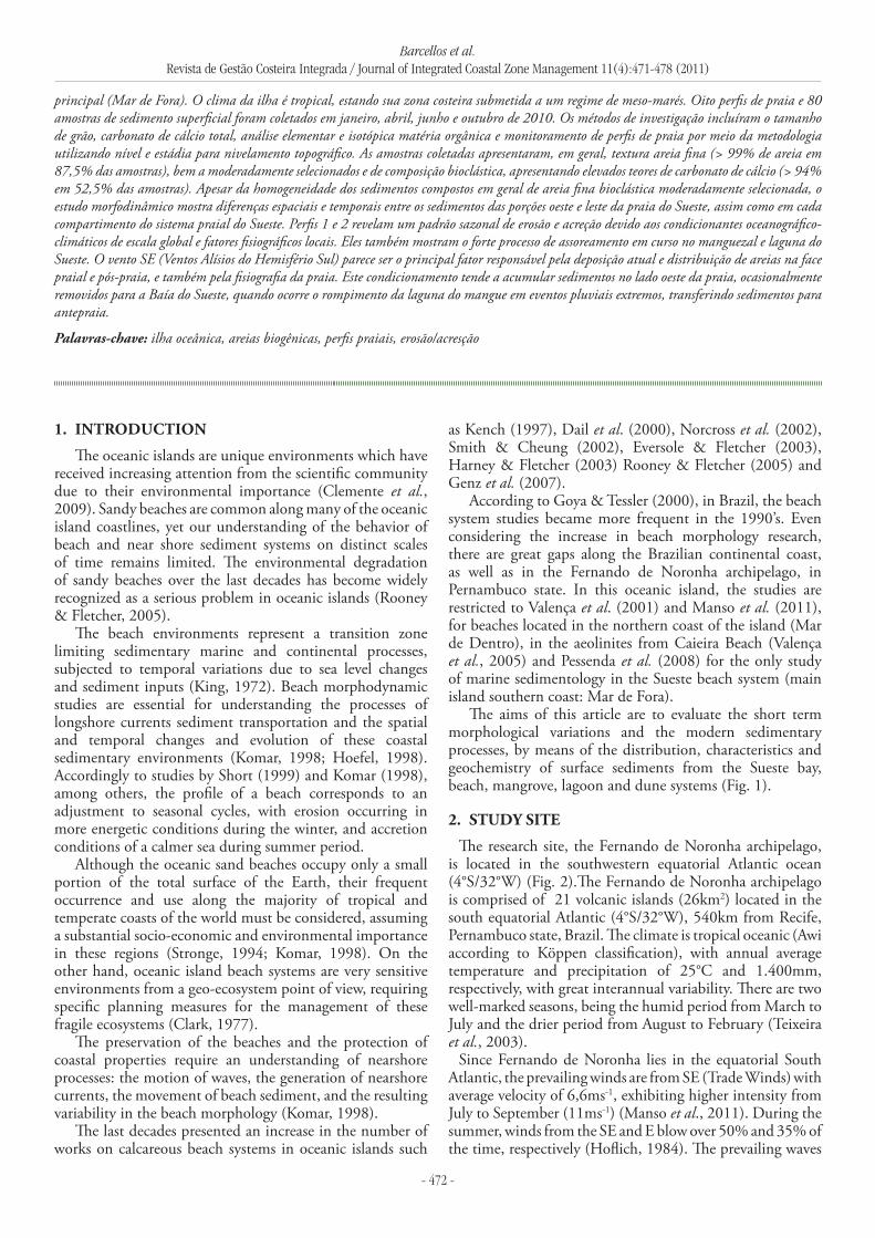
Figure 1. Aerial view of Sueste bay and beach system (Photograph of Roberto L. Barcellos, january/2010).Figura 1. Fotografia aérea da Baía do Sueste do sistema praial (Fotografia de Roberto L. Barcellos, janeiro/2010).
2.1 sueste mangrove
The mangrove (8.900 m2), associated to the Maceió river drainage, is isolated from the beach by a vegetated dune system (2,5 m in height), except in a portion adjacent to the Maceió
Barcellos et al.Revista de Gestão Costeira Integrada / Journal of Integrated Coastal Zone Management 11(4):471-478 (2011)
- 474 -
4. rEsULts AND DIscUssION
4.1 Modern sedimentary processes and seasonal morphology variations in the sueste beach system
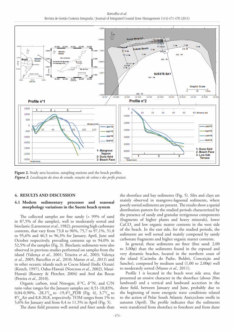
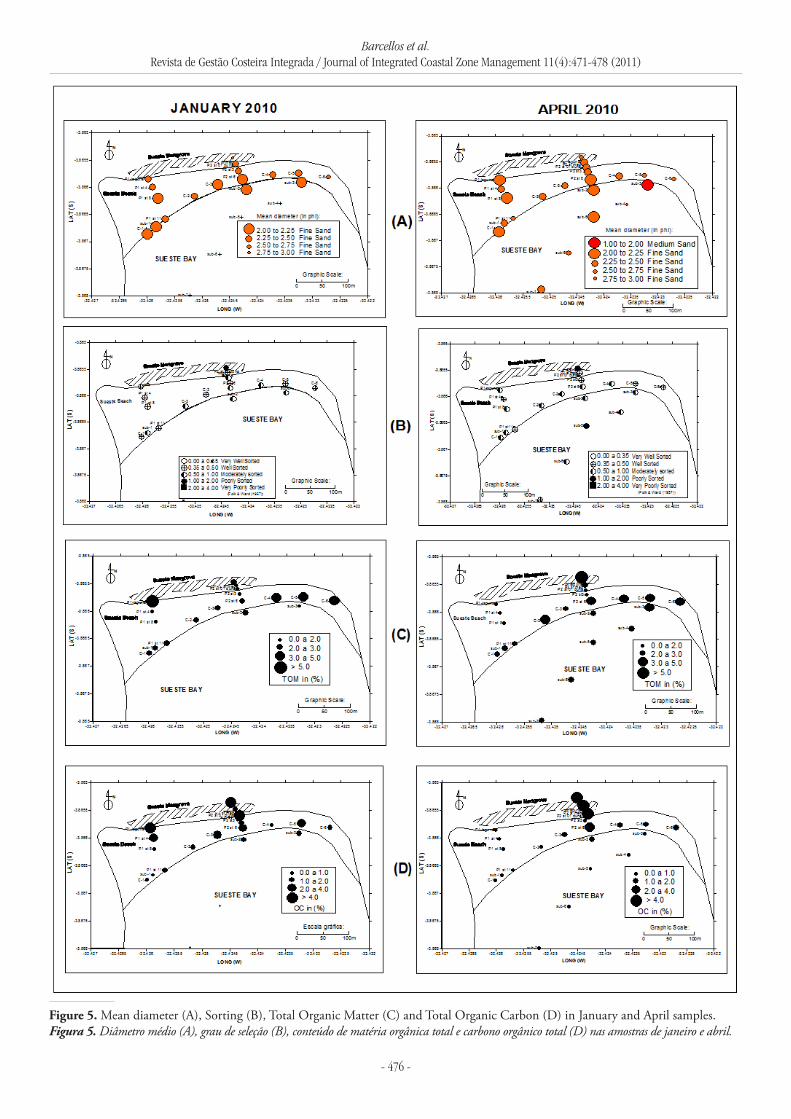
The collected samples are fine sandy (> 99% of sand in 87,5% of the samples), well to moderately sorted and bioclastic (Larssoneur et al., 1982), presenting high carbonate contents, that vary from 73,8 to 96%, 75,7 to 97,1%, 51,8 to 95,6% and 46,5 to 96,3% for January, April, June and October respectively, prevailing contents up to 94,0% in 52,5% of the samples (Fig. 3). Bioclastic sediments were also observed in previous studies performed on samples from the island (Valença et al., 2001; Teixeira et al., 2003; Valença et al., 2005; Barcellos et al., 2010; Manso et al., 2011) and in other oceanic islands such as Cocos Island (Indic Ocean) (Kench, 1997), Oahu-Hawaii (Norcross et al., 2002), Maui-Hawaii (Rooney & Fletcher, 2004) and Atol das Rocas (Pereira et al., 2010).
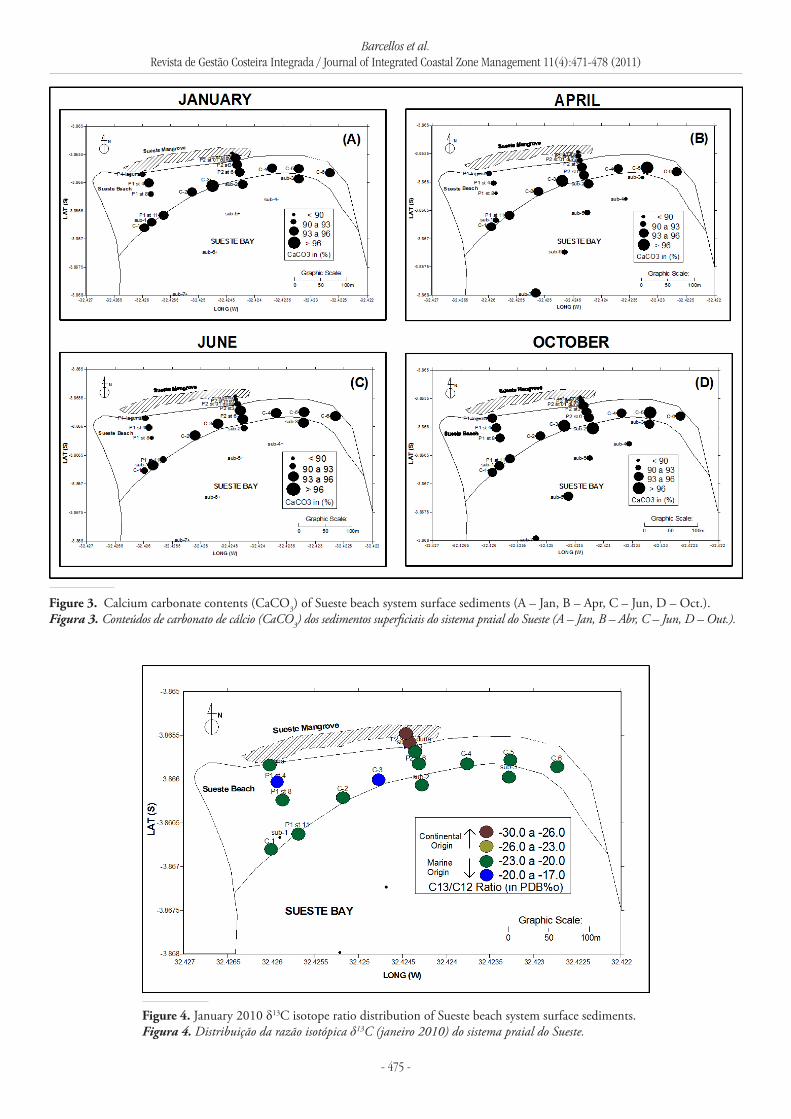
Organic carbon, total Nitrogen, δ13C, δ15N, and C/N ratio value ranges for the January samples are: 0,51-10,83%, 0,04-0,90%, -28,10/00 to -19,40/00PDB (Fig. 4), 3,70/00 to 80/00Air and 8,8-20,8, respectively. TOM ranges from 1% to 5,6% for January and from 0,4 to 11,5% in April (Fig. 5).
The dune field presents well sorted and finer sands than
the shoreface and bay sediments (Fig. 5). Silts and clays are mainly observed in mangrove-lagoonal sediments, where poorly sorted sediments are present. The results show a spatial distribution pattern for the studied periods characterized by the presence of sandy and granular terrigenous components (fragments of higher plants and heavy minerals), lower CaCO3 and low organic matter contents in the west side of the beach. In the east side, for the studied periods, the sediments are well sorted and mainly composed by sandy carbonate fragments and higher organic matter contents.
In general, these sediments are finer (fine sand: 2,00 to 3,00ϕ) than the sediments found in the exposed and very dynamic beaches, located in the northern coast of the island (Cacimba do Padre, Boldró, Conceição and Sancho), composed by medium sand (1,00 to 2,00ϕ) well to moderately sorted (Manso et al., 2011).
Profile 1 is located in the beach west side area, that presented an erosive character in the shoreface (about 20m landward) and a vertical and landward accretion in the dune field, between January and June, probably due to the beginning of more energetic wave conditions related to the action of Polar South Atlantic Anticyclone swells in autumn (April). The profile indicates that the sediments were transferred from shoreface to foreshore and from dune
Figure 2. Study area location, sampling stations and the beach profiles.Figura 2. Localização da área de estudo, estações de coleta e dos perfis praiais.
Barcellos et al.Revista de Gestão Costeira Integrada / Journal of Integrated Coastal Zone Management 11(4):471-478 (2011)
- 475 -
Figure 4. January 2010 δ13C isotope ratio distribution of Sueste beach system surface sediments.Figura 4. Distribuição da razão isotópica δ13C (janeiro 2010) do sistema praial do Sueste.
Figure 3. Calcium carbonate contents (CaCO3) of Sueste beach system surface sediments (A – Jan, B – Apr, C – Jun, D – Oct.).Figura 3. Conteúdos de carbonato de cálcio (CaCO3) dos sedimentos superficiais do sistema praial do Sueste (A – Jan, B – Abr, C – Jun, D – Out.).
Barcellos et al.Revista de Gestão Costeira Integrada / Journal of Integrated Coastal Zone Management 11(4):471-478 (2011)
- 476 -
Figure 5. Mean diameter (A), Sorting (B), Total Organic Matter (C) and Total Organic Carbon (D) in January and April samples.Figura 5. Diâmetro médio (A), grau de seleção (B), conteúdo de matéria orgânica total e carbono orgânico total (D) nas amostras de janeiro e abril.
Barcellos et al.Revista de Gestão Costeira Integrada / Journal of Integrated Coastal Zone Management 11(4):471-478 (2011)
- 477 -
field to the adjacent mangrove and lagoon, subjected to a strong silting process. In October, profile 1 was similar to January, exhibiting a growth of shoreface in 30m in the ocean direction, an erosion of the dune field top and the continuity of lagoon/mangrove silting process. The dunes erosion and shoreface/foreshore accretion observed in the October profile may be related to the lagoon mouth opening that occurred in July 7th after rainy days, transferring part of the sediments accumulated in backshore for the shoreface. Due to the enclosed conditions of the beach, it seems to be more effective to mophodynamic observed changes, the wind transportation in the shoreface than the effectiveness of the longshore current.
The erosive pattern was not observed in profile 2, which exhibits a relative stability, presenting an accretion of about 8m in the ocean direction only for the October profile. As in profile 1, the observed accretion process is directly related to trade winds sediments transport, more effective in July to September in the tropical south Atlantic. This wind (SE) induces the transport of sediments from C-4 sample station area westward, as indicated by the sediments distribution, characteristics and beach morphology (2 times wider in the W side). On the other hand, the east side sedimentation (C-5 and C-6 sampling area) is induced by a weak longshore current in the opposite direction, west to east.
A conjunction of factors creates the conditions for this observed behavior in the Sueste beach morphology and sedimentary distribution. This distribution is directly related to the presence of terrigenous sediment sources in the west side, due to wave action in the adjacent volcanic rock cliffs and the Maceió river local sporadic sediment input. A higher exposure of the western side of Sueste beach to the wave action and prevailing trade winds, added to a parallel current convergence process induced by refraction and diffraction of SW/S/SE/E waves in the Sueste bay entrance, also contributing for the observed spatial sediment pattern distribution and composition, and beach morphology. In fact, Norcross et al. (2002) propose for a reef fringed pocket beach (Kailua Bay-Oahu-Hawaii), a simple transport pattern to account for these observed morphological fluctuations, which depends in part on the topography of the adjacent reefs.
Despite the homogeneity of fine sandy bioclastic moderately sorted sedimentation, this morphodynamic study shows spatial and temporal differences between the sediments of the west and the east side of the Sueste beach, as well as in each compartment of Sueste beach/bay System. Profile 1 indicates a seasonal pattern in sediments accretion/erosion directly related to oceanographic-climatic conditions. This profile also reveals the strong silting process in course on the Sueste mangrove and lagoon. The SE wind (Southern Hemisphere Trade Wind) is the main factor for this modern deposition, beach physiography and the distribution of sediments in the Sueste beach shoreface and backshore. The sediments accretion in profile 2, observed in October, also indicate the effectiveness of the SE wind in sediment transport and accumulation in the Sueste beach system. This pattern accumulates sediments in the beach west side, occasionally removed for the Sueste Bay when the mangrove lagoon breaks in the huge rain events. As observed
by Norcross et al. (2002) for Kailua Bay (Hawaii), this behavior suggests: (1) that the longshore rather than cross-shore sand transport is important at seasonal time scales; (2) Although seasonal sand accumulation varies along the beach, the overall beach profile is largely maintained.
The results and discussions presented in this work are an important part of the preliminary phase of the current research. In this paper the partial data from 4 of 7 field works programmed for 2010-2011 years in the Sueste beach system are presented.
AcKNOwLEDgEMENts
The authors wish to express their thanks to Pedro de Souza Pereira from the Oceanography Department of Pernambuco Federal State University, for their discussion over beach systems morphology and sedimentary processes. Thanks are also due to Mr. Gustavo Lima Barcellos, for revising the text, and to Fernanda C. P. de Souza e Heverton P. A. de Oliveira, for the sedimentary analysis. The authors are also indebted to the National Research Council (CNPq) for financial support given for the project (Proc. n° 577369/2008-3): “Environmental Diagnosis of Sueste Mangrove, Fernando de Noronha Archipelago, Pernambuco State, Brazil”.
rEFErENcEs
Almeida, F.F.M. (2006) - Ilhas oceânicas brasileiras e suas relações com a tectônica atlântica. Terrae Didática (ISSN: 1980-4407), 2(1):3-18, Campinas, SP, Brasil. http://www.ige.unicamp.br/terraedidatica/v2/pdf-v2/t_didatica_2006_v02n01_p003-018_almeida.pdf
Barcellos, R.L.; Coelho JR., C; Travassos, P.E.P.F; Lins, S.R.R.M; Silva, M.S.; Guerra, N.C.; Severi, W. (2010) - Distribuição do carbonato biodetrítico (CaCO3) em sedimentos da praia e manguezal do Sueste, Fernando de Noronha, estado de Pernambuco. IV° Congresso Brasileiro de Oceanografia, Cd room, FURG, Rio Grande, RS, Brasil.
Goya, S.C. y; Tessler, M.G. 2000. Variações morfológicas espaço-temporais entre as praias de Cibratel e Itanhaém-Suarão, estado de São Paulo. Revista Brasileira de Oceanografia (ISSN: 1679-8759), 48(2):151-166, São Paulo, SP, Brasil.
Clark, J.R. (1977) - Coastal Ecosystem Management. 928p, John Wiley & Sons, New York, NY, U.S.A. ISBN: 0471158542
Clemente, E.P.; Shaefer, C.E.G.R.; Oliveira, F.S.; Albuquerque-Filho, M.R.; Alves, R.V.; Sá, M.M.F.; Melo, V.F.; Correa, G.R. (2009) - Topossequência de solos na ilha da Trindade, Atlântico Sul. Revista Brasileira de Ciência do Solo (ISSN: 0100-0683), 33(5):1357-1371, Viçosa, MG, Brasil.
Dail, H.J.; Merrifield, M.A.; Bevis, M. (2000) - Steep beach morphology changes due to energetic wave forcing. Marine Geology: 162(2-4):443-458. DOI: 10.1016/S0025-3227(99)00072-9.
Emery, K.O. (1961) - A simple method of measuring beach profile. Limnology and Oceanography, 6(1):90-93. http://www.aslo.org/lo/toc/vol_6/issue_1/0090.pdf
Barcellos et al.Revista de Gestão Costeira Integrada / Journal of Integrated Coastal Zone Management 11(4):471-478 (2011)
- 478 -
Eversole, D.; Fletcher, C.H. (2003) - Longshore sediment transport rates on a reef-fronted beach: field data and empirical models Kaanapali Beach, Hawaii. Journal of Coastal Research (ISSN: 0749-0208),19(3):649-663, West Palm Beach, FL, U.S.A.
Folk, R.L.; Ward, W.C. (1957) - Brazos river bar: study of the significance of grain size parameters. Journal of Sedimentary Petrology 27(1):3-26.
Harney, J.N.; Fletcher, C.H. (2003) - A budget of carbonate framework and sediment production, Kailua Bay, Oahu, Hawaii. Journal of Sedimentary Research: 73(6):856-868. DOI: 10.1306/051503730856.
Hedges, J.I., Stern. J.H. (1984) - Carbon and nitrogen determinations in carbonate-containing solids. Limnology and Oceanography (ISSN: 0024-3590), 29(3):657-663. ISSN: 0024-3590.
Hoefel, F.G. (1998) - Morfodinâmica de praias arenosas oceânicas: uma revisão bibliográfica. 92p, Editora da Universidade do Vale do Itajaí, Itajaí, SC, Brasil. ISBN: 8586447080.
Hoflich, O. (1984) - Climate of the South Atlantic Ocean. In: Van Loon H. (ed.), Climates of the oceans, pp.1-192. Elsevier Science, Amsterdam, The Netherlands. ISBN: 978-0444413376.
Genz, A.S.; Fletcher, C.H.; Dunn, R.A.; Frazer, L.N.; Rooney, J.J. (2007) - The predictive accuracy of shoreline change rate methods and alongshore beach variation on Maui, Hawaii. Journal of Coastal Research, 23(1),87-105. DOI: 10.2112/05-0521.1.
Ingram, R. L. (1971) - Sieve analysis. In: Carver, R.E. (ed.), Procedures in Sedimentary Petrology, pp.49-69, Wiley Interscience, New York, NY, U.S.A. ISBN: 9780471138556.
Kench, P.S. (1997) - Contemporary sedimentation in the Cocos (Keeling) Islands, Indian Ocean:interpretation using settling velocity analysis. Sedimentary Geology 114(1-4):109-130. DOI: 10.1016/S0037-0738(97)00082-1.
King, C.A.M. (1972) - Beaches and coasts. 2nd ed., 570p., Edward Arnold, London, U.K. ISBN: 9780713156096.
Komar, P.D. (1998) - Beach Processes and sedimentation. 2nd ed., 544p., New Jersey, Prentice and Hall, Inglewood Cliffs, New Jersey, U.S.A. ISBN: 9780137549382.
Larssoneur, C.; Bouysse, P.; Auffret, J.P. (1982) - The superficial sediments of the English channel and its western approach. Sedimentology, 29(6):851-864. DOI: 10.1111/j.1365-3091.1982.tb00088.x
Manso, V.A.; Menor, E.A.; Valença, L.M.M.; Neumann, V.H.M.L.; Pereira, N.S; Junior, C.F.A.S.; Silva, E.R.M. (2011) - Morfodinâmica de praias setentrionais da Ilha de Fernando de Noronha. Revista da Gestão Costeira Integrada, 11(3):327-339. DOI: 10.5894/rgci239.
Müller, G. (1967) - Methods in Sedimentary Petrology (Part I). 283p, Hafner Publishing Co., New York, NY, U.S.A. ISBN: 978-3-510-65006-4.
Norcross, Z.M.; Fletcher, C.H.; Merrifield, M. (2002) - Annual and interannual changes on a reef-fringed pocket beach: Kailua Bay, Hawaii. Marine Geology, 190(3-4):553-580. DOI: 10.1016/S0025-3227(02)00481-4
Pessenda, L.C.R.; Gouveia, S.E.M.; Ledru, M.P.; Aravena, R.; Ricardi-Branco, F.S; Bendassolli, J.A.; Ribeiro, A.S; Saia, S.E.M.G.; Siffeddine, A.; Menor, E.A.; Oliveira, S.M.B.; Cordeiro, R.C.; Freitas, A.M.M.; Boulet, R.; Filizola, H.F. (2008) - Interdisciplinary paleovegetation study in the Fernando de Noronha island (Pernambuco state), NE Brazil. Anais da Academia Brasileira de Ciências (ISSN: 0001-3765), 80(4):677-691, Rio de Janeiro, RJ, Brasil.
Pereira, N.S.; Manso, V.A.V.; Silva, A.M.C.; Silva, M.B. (2010) - Mapeamento geomorfológico e morfodinâmica do Atol das Rocas, Atlântico Sul. Revista da Gestão Costeira Integrada 10(3):331-345. http://www.aprh.pt/rgci/pdf/rgci-209_Pereira_small.pdf
Rooney, J.J.B.; Fletcher, C.H. (2005) - Shoreline change and Pacific climatic oscillations in Kihey, Maui, Hawaii. Journal of Coastal Research (ISSN: 0749-0208), 21(3):535-547. West Palm Beach, FL, U.S.A.
Shepard, F.P. (1954) - Nomenclature Based on Sand-Silt-Clay Ratios. Journal of Sedimentary Petrology, 24(3):151-158. DOI:10.1306/D4269774-2B26-11D7-8648000102C1865D
Short, A.D. (1999) - Handbook of Beach and Shoreface Morphodynamics. 379p., J. Wiley & Sons, New York, NY, U.S.A. ISBN: 9780471965701.
Smith, D.A.; Cheung, K.F. (2002) - Empirical relationships for grain size parameters of calcareous sand on Oahu, Hawaii. Journal of Coastal Research: 18(1):82-93. http://www.jstor.org/stable/4299056.
Stronge, W.B. (1994) - Beaches, tourism, and economic development. Shore and Beach (ISSN: 0037-4237), 62(2):6-8, Fort Myers, FL, U.S.A.
Teixeira, W.; Cordani, U.G.; Menor, E.A.; Teixeira, M.G.; Linsker, R. (2003) - Arquipélago de Fernando de Noronha o paraíso do vulcão. 167p., Terra Virgem Editora, São Paulo, SP, Brasil. ISBN: 8585981318.
Valença, L.M.M.; Manso, V.A.; Menor, E.A. (2001) - Estudo morfodinâmico preliminar das praias da Ilha de Fernando de Noronha. Anais do VIII° Congresso da ABEQUA, 537-538, Universidade Federal de Rio Grande do Sul, Centro de Estudos de Geologia Costeira e Oceânica (CECO-UFRGS), Imbé, RS, Brasil.
Valença, L.M.M.; Neumann, V.H.; Menor, E.A.; Santos, C.E.R.R. (2005) - Eolianitos de Fernando de Noronha: uma análise integrada de estudos petrográficos e geoquímicos. Anais do X° Congresso da ABEQUA, p.37-39, Universidade Federal do Espírito Santo (UFES), Guarapari, ES, Brasil.