Embed Size (px)
Citation preview


Goulburn Broken Waterway Strategy 2014-2022 P a g e | ii
Published by:
Goulburn Broken Catchment Management Authority,
PO Box 1752, Shepparton 3632
© Goulburn Broken Catchment Management Authority, 2014.
Please cite this document as: GBCMA (2014) Goulburn Broken Waterway Strategy 2014-2022, Goulburn Broken Catchment Management Authority, Shepparton.
ISBN: 978-1-876600-04-4
Disclaimer
This publication may be of assistance to you, but the Goulburn Broken Catchment Management Authority does not guarantee that the publication is without flaw of any kind or is wholly appropriate for your particular purposes and therefore disclaims all liability for any error, loss or other consequences that may arise from you relying on information in this publication.
Note specific reference to funding levels in this strategy are for indicative purposes only. The level of Government investment in this strategy will depend upon budgets and Government priorities
For further information, please contact:
Goulburn Broken Catchment Management Authority
Waterways, Wetlands and Strategic River Health
P.O. Box 1752, Shepparton 3632
Ph. (03) 5822 7700
Visit: www.gbcma.vic.gov.au
Front cover photo credits from left to right (top row): Canoeing on the Goulburn River (GB CMA); Lake Benalla from Monash Bridge (Kirsten Hein, Mark Ainsworth); Murray cod returned to the river (Wally Cubbin); Sunday Creek, Mt Disappointment (Krissi Flynn); (second row): Kirwans Bridge Victoria (Wally Cubbin); Fishing Goulburn River along Majors Creek (Wally Cubbin); Goulburn River at Molesworth (Belinda Fisher); Water for agriculture (C. Sexton, GB CMA).

Goulburn Broken Waterway Strategy 2014-2022 P a g e | iii
Our Strategy The Goulburn Broken Waterway Strategy (the Strategy), together with a range of related sub-strategies, underpin the Regional Catchment Strategy (RCS). This Strategy presents an integrated catchment planning framework for waterways in the Goulburn Broken region and is the primary guide for priority setting, maintenance and improvement of our waterways.
Seven Creeks, Gooram Falls (GB CMA)
Our Vision Resilient Waterways, Vibrant Communities.
The Goulburn Broken region’s waterways are vibrant and resilient, so that communities can enjoy the values and benefits that they provide and contribute to their maintenance and improvement.

Goulburn Broken Waterway Strategy 2014-2022 P a g e | iv
Foreword Waterways (rivers and wetlands) are the lifeblood of our region. They are also the barometer by which we can assess the current and past management of our waterways and surrounding catchment and how well we are achieving “clean green agriculture”, which is so important for the prosperity of our rural community.
We now have evidence to demonstrate the benefit of the implementation of the previous Regional River Health Strategy. For example, sensitive instream works and establishing appropriate vegetation on frontages has reduced bank erosion and promoted faster natural revegetation recovery following flood events. This has also been the case for post-bushfire recovery. Another critical result provided by works is the reduction of phosphorous and nitrogen into our waterways which in turn reduces the likelihood of algal blooms and low oxygen events in some waterways, particularly over summer.
We now have better tools to improve the resilience of some ecosystems or reduce their chance of loss or decline.
The Goulburn Broken Catchment Management Authority (GB CMA), as the lead agency for natural resource management in the catchment, is responsible for the development and oversight of a regional catchment strategy framework together with our community and partners.
The Goulburn Broken Waterway Strategy is one of several sub-strategies underpinning the Goulburn Broken Regional Catchment Strategy (RCS). The RCS presents the high-level priorities, outputs and outcomes at the catchment scale, whereas this Strategy presents the detail and supporting framework relevant to waterway management to enable delivery of the strategic intent of the RCS.
This Strategy applies an asset-based approach and incorporates resilience-based thinking for maintaining and improving the social, economic, cultural and environmental values of waterways. The Strategy recognises the vast range of social, environmental, cultural and economic values that waterways provide to our regional community and visitors alike.
This Strategy reflects on the vast amount of work the community has achieved over many years and incorporates recent environmental and policy drivers and knowledge gained through research and monitoring. It identifies the key threats to important values and provides recommendations to influence the future management of waterways in the catchment. Actions to maintain and improve our waterways are clearly established.
The GB CMA recognises its critical role in forming and developing regional partnerships with the community and all levels of government. Success in implementing this Strategy will occur through partnerships with our community and government agencies.
The Strategy is a living document that will be continuously improved and updated over its life.
We wish to acknowledge the contribution of our community in the development of the Strategy. Our community has identified values and threats, participated on the Community Reference Group and provided photographs depicting the way in which their local waterway is valued. Our partner agencies have also supported the development of the Strategy through input on Reference Groups and direct contribution to Chapters within this Strategy.
We seek your support in the implementation of this Strategy so the region’s valued waterways can be maintained and improved, for now and into the future and we can maintain their value as an important tourism asset and the harmony in which this asset sits with agricultural production.
Murray Chapman Chair Goulburn Broken Catchment Management Authority
Chris Norman Chief Executive Officer Goulburn Broken Catchment Management Authority

Goulburn Broken Waterway Strategy 2014-2022 P a g e | v
About Our Strategy Waterways (rivers and wetlands) are one of the most striking features of our landscape. They provide us with enjoyment, provide cultural values, and contribute significantly to the economic and social health of our region and our community.
There is no better time than now for people in all catchments of Australia to pause and celebrate how vital waterways are to the community, and to contribute towards their maintenance and improvement.
Local waterways are valued by local communities and the many visitors to the region as well as other users of our precious water resources well beyond our region.
Our waterways support many species of plants and animals unique to Australia (like the Murray cod, Platypus and the humble Yabby). Our waterways also provide billions of dollars to the economy, support one third of all food produced in Australia, provide our everyday drinking water, support tourism and provide recreational opportunities. They are indeed a key asset to us all.
Our catchment has great places to camp, including the Goulburn River and tributary streams, and is also the home of Barmah Forest, which together with the Millewa Forest in NSW, forms the largest River Red Gum forest in the world.
Fresh water is a scarce and precious resource in many areas across the globe. We are fortunate to have good water supplies in the most populated parts of Australia, but we have one of the driest climates in the world and our water reserves are limited. Many waterways are becoming increasingly polluted and work has commenced in the Murray-Darling Basin to better balance the water available for the health of the waterways.
Waterways in good condition provide a range of benefits for our regional industries, agriculture and the wider community (Jones 2001). Key benefits of services include, but are not limited to:
• provision of conduits for the supply of water for agriculture;
• water quality improvement (Hairsine 2001), which can reduce the cost of treatment prior to human usage;
• support for populations of native and introduced fish species popular with local and visiting anglers; and
• utilisation for tourism, recreation and aesthetics.
This Strategy reflects on the vast amount of work the community has achieved over many years and incorporates recent environmental and policy drivers and knowledge gained through research and monitoring. It identifies key threats to community values and provides recommendations to influence the future management of waterways in the catchment.
While our community is already taking action to maintain waterways, there is still more that can be done. Taking positive action is the best way to help our waterways.
Communities can assist in maintaining and improving our waterways, by:
• finding out about our local waterways (and the values they contain/provide);
• maintaining and managing buffer areas by fencing and re-establishing native vegetation;
• maintaining and improving public reserves for waterway health;
• getting involved with and encouraging participation in native fish and river health education programs; and
• working with local groups on waterway projects (for example, Waterwatch, Landcare, Indigenous groups and recreational anglers).

Goulburn Broken Waterway Strategy 2014-2022 P a g e | vi
This Strategy encourages our community to enjoy our waterways and contribute to their maintenance and improvement.
A review of works undertaken over recent years provides confidence that we are maintaining and improving many elements and reaches of the region’s waterways. Examples include a reduction in the level of nutrients entering our waterways, maintenance of threatened species (even after being subjected to bushfire and drought) and maintaining rivers in the catchment as prime recreational areas.
The Strategy is one of several sub-strategies supporting the Goulburn Broken Regional Catchment Strategy (RCS). The RCS presents a framework and vision for integrated catchment management in the region, identifies land, water and biodiversity assets, sets 20 year condition objectives for those assets, and outlines regional priorities and management measures to achieve the objectives.
The intent of this Strategy is to:
• identify priority waterways based on their environmental, social, cultural and economic values, and set objectives for their management;
• develop a work and activity program to achieve these objectives, and targets against which to measure progress in reaching these objectives;
• provide a consistent, defensible process for identifying priorities for government investment in waterways; and
• engage key stakeholders and the community in the process of developing the Strategy to ensure that the priority assets chosen reflect areas of high community value.
This Strategy has been structured and compiled with input from our community and our many partners. The Strategy is a living document that will be regularly reviewed and updated over its life. This will require continuous engagement of community and partner agencies to ensure an adaptive management approach is used to improve the resilience of our waterways and catchment as we face the challenges of the future together. As part of this approach, we have been undertaking a new challenge in developing a workable resilience matrix for waterways based on sound science.
The Strategy comprises four major sections:
• PART A – Regional Overview and Strategic Context;
• PART B – The Approach, Vision, Goals and Guiding Principles;
• PART C – Regional Program – Implementation of Management Activities; and
• PART D – Implementing the Strategy.
The Strategy identifies priority waterways for investment into the next decade and identifies strategic challenges and opportunities.
The Strategy also includes management planning for the Barmah Forest Ramsar Site in accordance with Action 12.3 of the Victorian Waterway Management Strategy (2013).
A number of filters have been applied to develop a list of priority waterways from the large list of waterways identified within the Index of Stream Condition and Index of Wetland Condition. Filter one applied the definition of high value waterways as identified within the Victorian Waterway Management Strategy (2013) followed by filter two, which used the list of regional goals established by the Community Reference Committee.

Goulburn Broken Waterway Strategy 2014-2022 P a g e | vii
Filter One: waterways are considered high value if they have one, or more, of the following characteristics:
• formally recognised significance;
• presence of highly threatened or rare species and ecological communities;
• high naturalness values (for example, aquatic invertebrate communities or riparian vegetation) or special waterway features (for example, drought refuges or important bird habitat); and
• high social, cultural or economic values (for example, recreational fishing, Aboriginal cultural heritage and urban or rural water sources).
Filter Two: involved identifying waterways with values relating to regional goals established by the Community Reference Committee to maintain the resilience of the region’s waterways to ensure:
• waterways of high community value are maintained or improved;
• water quality in priority water supply catchments is maintained or improved;
• populations of threatened aquatic dependent species will be maintained or improved (including Trout cod, Macquarie perch, Murray cod, Eel tailed catfish, Barred galaxias, Golden perch);
• Barmah Forest (Ramsar site) will be managed to maintain its ecological character;
• the values associated with Heritage Rivers will be maintained or improved;
• wetlands with formally recognised significance are maintained or improved;
• waterways in a near-natural or ecologically healthy state are retained; and
• urban waterways are managed to improve environmental condition, amenity and water security.
Additional filters include application of the risk-based assessment contained within AVIRA (Aquatic Value Identification and Risk Assessment) and finally, a feasibility review of management activities.
Over the next eight years, investment will target priority waterways within the six Social Ecological Systems1 (SES). Priority waterways are defined by reach or wetland identification number and name within each SES (e.g. Basin - Waterway Reach (5-54), and Waterway Name (Broken River) or Wetland ID and Name):
AGRICULTURAL FLOODPLAINS: 4-01 Broken River 4-21 Broken Creek 4-22 Broken Creek 4-23 Broken Creek 4-24 Broken Creek 4-32 Boosey Creek 4-36 Tullah Creek 5-01 Goulburn River 5-02 Goulburn River 5-03 Goulburn River 5-04 Goulburn River 5-05 Goulburn River 60101 One Tree Swamp 60102 Two Tree Swamp 60118 Gaynors Swamp 60205 Kanyapella Basin 60240 Yambuna Bridge Rd 60265 Mansfield Swamp 60269 Wallenjoe Swamp 60706 Barmah Forest 62010 Doctors Swamp 63156 Gemmills Swamp 63173 Reedy Swamp 63203 Black Swamp 63206 Kinnairds Wetland 66906 Sampys Swamp 66911 Taylors Swamp 67091 Mulquiney Rd
PRODUCTIVE PLAINS: 4-03 Broken River 4-13 Holland Creek 4-34 Boosey Creek 5-06 Goulburn River 5-07 Goulburn River 5-08 Goulburn River 5-09 Goulburn River 5-10 Goulburn River 5-17 Seven Creeks 5-18 Seven Creeks 5-19 Seven Creeks 5-20 Seven Creeks 5-22 Honeysuckle Creek 5-23 Honeysuckle Creek 5-37 Hughes Creek 5-76 Honeysuckle Creek 61918 Tahbilk Lagoon 62900 Stockyard Plain 67053 Moodie Swamp 67905 Dowdle Swamp 67909 Winton Wetland Complex
1 The RCS identifies seven SESs including a Catchment Wide SES. Priority waterways within the Catchment Wide SES have not been listed as they incorporate all the priority waterways and wetlands listed in the other six SESs.

Goulburn Broken Waterway Strategy 2014-2022 P a g e | viii
UPLAND SLOPES: 4-04 Broken River 4-05 Broken River 4-06 Broken River 4-08 Five Mile Creek 4-10 Lima East Creek 4-11 Sawpit Gully Creek 4-14 Holland Creek 4-16 Ryans Creek 4-17 Ryans Creek 5-13 Goulburn River 5-14 Goulburn River 5-38 Hughes Creek 5-39 Hughes Creek 5-62 Acheron River 5-73 Ford Creek 5-74 Brankeet Creek 5-75 Merton Creek
COMMUTING HILLS: 5-11 Goulburn River 5-12 Goulburn River 5-42 Mollison Creek 5-43 Mollison Creek 5-47 Sunday Creek 5-51 King Parrot Creek 5-55 Yea River 5-56 Yea River
SOUTHERN FORESTS: 5-15 Goulburn River 5-16 Goulburn River 5-63 Acheron River 5-64 Taggerty River 5-65 Rubicon River 5-66 Rubicon River 5-67 Big River 5-68 Big River 5-69 Howqua River 5-70 Howqua River 5-71 Delatite River 5-72 Delatite River CHP/AB Central Highland Peatlands and Alpine Bogs
URBAN CENTRES: a number of townships surround or run parallel to key waterway systems throughout the Goulburn Broken region.
Township and waterway interface creates a separate set of circumstances in waterway management. Social and economic values are heightened and direct threats imposed on waterway values are increased. Urban waterway management plans should be developed and implemented in partnership with the community on priority waterways.
High-level outcomes have been developed for each Social Ecological System in the region. Table E-1 (below) details key performance indicators (KPIs) for each SES as developed within the Victorian Waterway Management Strategy. Outcomes have been developed on the basis of priority waterway needs and current forward funding estimates.
In addition, challenges and opportunities facing waterways within the Goulburn Broken region have been identified for the Catchment Wide SES.
This Strategy is a living document that will be continuously improved by adaptive management and updated, as required, over its lifespan. A formal annual and interim (mid-term) review process is recommended to review progress on the Strategy and adapt to changes in the environment and our knowledge base.
The review and implementation process will require continuous engagement of our community and partner agencies to ensure an adaptive management approach is used to improve the resilience of the catchment and its waterways and ensure it continues to provide our community with an array of social, economic, cultural and environmental values.
We look forward to implementing this strategy with the region’s communities and partner agencies.

Goulburn Broken Waterway Strategy 2014-2022 P a g e | ix
Table E-1: High-level outcomes by Social Ecological System (2014-2022)
High level outcomes Agricultural Floodplains Productive Plains Upland Slopes Commuting Hills Southern Forests
no. sites with instream habitat established KPI 1 8 11 8 4 3
no. of fish barriers addressed KPI 2 2 8 2 0 1 km of riparian fencing KPI 3 13 41 59 40 9 ha of fenced wetlands KPI 4 0 0 0 0 0 ha of indigenous vegetation KPI 5 90 93 35 25 19 ha managed for pest plants
KPI 6 3550 750 20 100 527
ha managed for pest animals 2620 640 101 100 400 km treated for soil erosion KPI 7 0.4 0.6 6.4 0 0 no. reaches with water managed to meet environmental objectives KPI 8
9 5 1 2 0
no. wetlands with water managed to meet environmental objectives 11 2 0 0 0
no. sites monitored for asset condition KPI 9 0 0 0 0 2 no. of community groups supported KPI 10 6 0 0 0 0 ha covered by management agreements KPI 11 12 112 113 130 14 no. permits processed and planning referrals received (pa) KPI 12 850
ha modified grazing regime 5 147 113 80 14 no. ecological monitoring projects 1 1 2 2 7 no. strategies / management or recovery plans 4 0 0 0 0
no reaches with improved floodplain connectivity 3 0 0 0 0
ha of agricultural practice change 1390 1210 310 530 0
Outcomes in Table E-1 were established based on current forward funding estimates.

Goulburn Broken Waterway Strategy 2014-2022 P a g e | x
Table of Contents PART A Regional Overview and Strategic Context Our Strategy ............................................................................................................................................................ iii
Our Vision ............................................................................................................................................................... iii
Foreword................................................................................................................................................................. iv
About Our Strategy .................................................................................................................................................. v
Table of Contents ..................................................................................................................................................... x
Acknowledgement of Traditional Owners ............................................................................................................ xiv
Acknowledgements .............................................................................................................................................. xiv
Chapter authors ..................................................................................................................................................... xv
Photograph credits ............................................................................................................................................... xvi
Chapter One: ............................................................................................................................................................ 2
Introduction ............................................................................................................................................................. 2
1.1 Structure of the Document ...................................................................................................................... 2
1.2 The Waterway Strategy ........................................................................................................................... 3
1.3 Program Logic and Structure of the Document ....................................................................................... 4
1.4 Implementing the Strategy ...................................................................................................................... 5
1.5 Guiding Principles .................................................................................................................................... 5
Chapter Two: ........................................................................................................................................................... 7
Regional Overview: The Goulburn Broken Catchment ............................................................................................ 7
2.1 Waterways ............................................................................................................................................... 7
2.2 Waterways of the Goulburn River Basin .................................................................................................. 7
2.3 Waterways of the Broken River Basin ...................................................................................................... 8
2.4 Waterway Condition .............................................................................................................................. 10
2.5 Wetlands of the Goulburn Broken Region ............................................................................................. 12
2.6 Wetland Condition ................................................................................................................................. 14
2.7 Recognition of Aboriginal Values of Waterways .................................................................................... 14
2.8 Communities Value their Waterways .................................................................................................... 21
Chapter Three: ....................................................................................................................................................... 22
Strategic Context ................................................................................................................................................... 22
3.1 State Framework .................................................................................................................................... 22
3.2 Regional Framework for Waterway Management ................................................................................ 23
3.3 National Framework .............................................................................................................................. 24
3.4 International Framework ....................................................................................................................... 25
3.5 Formally Recognised Significance – Barmah Forest ............................................................................... 26
Goulburn Broken Waterway Strategy 2014-2022 P a g e | xi
3.6 Roles and Responsibilities of the CMA, Community and Partner Organisations ................................... 26
3.7 Review of the Goulburn Broken River Health Strategy (2005) .............................................................. 27
3.8 Protecting the Ecological Character of the Barmah Forest .................................................................... 33
Chapter Four: ......................................................................................................................................................... 47
Challenges and Opportunities ............................................................................................................................... 47
4.1 Management of Riparian Land............................................................................................................... 48
4.2 Water Quality ......................................................................................................................................... 55
4.3 Management of the Environmental Water Reserve .............................................................................. 59
4.4 Groundwater .......................................................................................................................................... 62
4.5 Floodplain Management ........................................................................................................................ 66
4.6 Public Infrastructure in our Waterways ................................................................................................. 67
4.7 Management of Threatened Aquatic Dependent Species ..................................................................... 69
4.8 Management of Recreational Fisheries ................................................................................................. 73
4.9 Management of Invasive Species ........................................................................................................... 75
4.10 Management of the River Channel ........................................................................................................ 78
4.11 Management of Extreme Events ........................................................................................................... 81
4.12 Influence of the Surrounding Catchment .............................................................................................. 84
4.13 Potential Impacts and Adaption to Climate Change .............................................................................. 90
4.14 Management and Use of Water Storages .............................................................................................. 95
PART B Our Approach to the Strategy Chapter Five: .......................................................................................................................................................... 98
Overview Of Approach ........................................................................................................................................... 98
5.1. Overview of Approach ........................................................................................................................... 98
5.2 Program Logic ........................................................................................................................................ 99
5.3 Vision and Regional Goals .................................................................................................................... 100
5.4 Aquatic Value Identification and Risk Assessment (Avira) – The Asset Based Approach .................... 101
5.5 Managing for Waterway Resilience ..................................................................................................... 102
Chapter Six: .......................................................................................................................................................... 106
Priority Setting ..................................................................................................................................................... 106
6.1 Identifying Priority Waterways ............................................................................................................ 106
6.2 Defining Waterways ............................................................................................................................. 106
6.3 Identifying High Value Waterways ....................................................................................................... 107
6.4 Priority Waterways .............................................................................................................................. 107
6.5 Developing the Regional Work Program .............................................................................................. 114

Goulburn Broken Waterway Strategy 2014-2022 P a g e | xii
PART C Regional Work Program - Implementation of Management Activities Chapter Seven: ..................................................................................................................................................... 118
The Action Plan .................................................................................................................................................... 118
7.1 Regional Work Program (8-Year Work Program) ................................................................................. 118
7.2 Agricultural Floodplains ....................................................................................................................... 119
7.3 Productive Plains .................................................................................................................................. 130
7.4 Upland Slopes ...................................................................................................................................... 141
7.5 Commuting Hills ................................................................................................................................... 148
7.6 Southern Forests .................................................................................................................................. 152
7.7 Urban Centres ...................................................................................................................................... 157
7.8 Assumptions ......................................................................................................................................... 160
7.9 Outcomes by SES/Landscape ............................................................................................................... 162
PART D Implementing the Strategy Chapter Eight: ...................................................................................................................................................... 166
Implementing the Strategy .................................................................................................................................. 166
8.1 Implementing the Strategy .................................................................................................................. 166
8.2 Maintenance ........................................................................................................................................ 166
8.3 Best Practice ........................................................................................................................................ 168
8.4 Compliance .......................................................................................................................................... 170
8.5 Monitoring and Evaluation .................................................................................................................. 171
8.6 Community Engagement ..................................................................................................................... 176
8.7 Roles and Responsibilities .................................................................................................................... 179
8.8 Cost-Sharing Principles for Waterway Management Programs .......................................................... 179
8.9 Strategy Review ................................................................................................................................... 180
8.10 Waterway Program Implementation Schedules .................................................................................. 181
References and further reading ........................................................................................................................... 182
PART E Appendices Appendix A: Partners and their roles and responsibilities in waterway management ............................................. i
Appendix B: Values and threats of waterways considered in the regional priority setting process ....................... v
Appendix C: AVIRA Metrics / Categories to be used to identify High Value waterways. ..................................... viii
Appendix D: Index of Stream Condition results (1999, 2004 and 2010) and Stream States by Social Ecological System ................................................................................................................................................................................. x
Appendix E: High value waterways and their associated values in the Goulburn Broken catchment, by landscape ..............................................................................................................................................................................xvii
Appendix F: High value wetlands by Social Ecological System (landscape) ......................................................... xxiii

Goulburn Broken Waterway Strategy 2014-2022 P a g e | xiii
Appendix G: Priority waterways ......................................................................................................................... xxxv
Appendix H - Priority wetlands .............................................................................................................................. xli
Appendix I - Costings applied to strategic priorities ............................................................................................... lii
Appendix J - Glossary of Terms .............................................................................................................................. liii
Appendix K - Acronyms .......................................................................................................................................... lvi
Appendix L: List of achievements from the last strategy (Goulburn Broken River Health Strategy 2005-2013) . lviii
Appendix M: Priority waterways (risk and feasibility) ........................................................................................... lix
Appendix N: Receipt of comments from community (that informed the preparation of the waterway strategy)lxii
Appendix O: Opportunities and challenges – (priority management actions) .................................................... lxiii

Goulburn Broken Waterway Strategy 2014-2022 P a g e | xiv
Acknowledgement of Traditional Owners The Goulburn Broken Catchment Management Authority and our community acknowledge the Traditional Owners of land, the Yorta Yorta Nations, Taungurung Clans and other custodians, in the Goulburn Broken catchment and strongly respect the rich culture and intrinsic connection the Traditional Owners have to the land – past, present and into the future.
Acknowledgements This Strategy has been prepared by the Goulburn Broken Catchment Management Authority with the support of the community and partner agencies.
The project has been led by the Waterway Strategy Community Reference Committee with the oversight of the GB CMA Board, and assistance of the Partnership Team, agency partners and the community. Members of the Committee wish to acknowledge the support provided from the following groups and individuals (in alphabetical order, with affiliations):
Community Reference Group Mr Barry Croke (Naringaningalook) Mr Bill Wells (Strathbogie) Mr Greg McKenzie (Kyabram) Ms Helen Reynolds (Congupna) Mr Jay Whittaker (Bunbartha) Ms Jill Breadon (Mansfield) Mr John Avard (Colbinabbin) Mr Peter Ingham (Murrindindi) Mr Wally Cubbin (Nagambie)
Partner Agencies Mr Mark Turner Goulburn Broken Catchment Management Authority Dr Anne Graesser Goulburn-Murray Water Mr Greg Smith Goulburn-Murray Water Mr Ken Ellis Goulburn-Murray Water Ms Carmel O'Dwyer Department of Environment and Primary Industries Mr Bruce Wehner Parks Victoria Mr Simon Casanelia Goulburn Broken Catchment Management Authority Ms Sue Berwick Department of Environment and Primary Industries Mr Dan McLaughlin Parks Victoria
We would also like to acknowledge the contribution of the Waterway Strategy Writers Group, staff at the Department of Environment and Primary Industries (in particular the Water and Catchment Group) and guidance provided from the overarching strategic document, the Victorian Waterway Management Strategy (2013).

Goulburn Broken Waterway Strategy 2014-2022 P a g e | xv
Chapter authors
Chapter 2.7: Recognition of Aboriginal values of waterways
Yorta Yorta Nations Aboriginal Corporation, (Neil Morris), Taungurung Clans Aboriginal Corporation (Meg Goulding)
Chapter 3.8: Protecting the ecological character of the Barmah Forest
Jennifer Hale
Chapter 4.1: Management of riparian lands Mark Turner (GB CMA) Chapter 4.2: Water quality Goulburn Broken Regional Water Quality Forum Chapter 4.3: Management of the environmental water reserve
Tim Barlow, Geoff Earl (GB CMA)
Chapter 4.4: Groundwater Matthew Hudson (Goulburn-Murray Water) Chapter 4.5: Floodplain management Guy Tierney (GB CMA) Chapter 4.7: Management of threatened aquatic dependent species
Jarod Lyon (Arthur Rylah Institute)
Chapter 4.8: Recreational fishing Judy Dixon (Mansfield Shire Council), David Kramer (Future Fish Foundation), Rob Loats (VRFish), Wally Cubbin (Goulburn Valley Association of Angling Clubs), Mark Turner (GB CMA), Mick Hall (Australian Trout Foundation), Julia Menzies, Russell Strongman, John Douglas and Anthony Forster (DEPI), Steven Trelfall (Trelly’s Tackle World) and Ron Lewis (Native Fish Australia)
Chapter 6: Priority setting Greg Peters (Riverness) Chapter 8.6: Community engagement Fiona Lloyd Strategic overview
Greg Woodward (DEPI), Amber Clarke (DEPI) and Statewide CMA Writing Group
AVIRA/population and data management Meegan Judd (GB CMA), Jodi Egginton, Andrea White (DEPI)
GB CMA and partner organisations Mark Turner, Simon Casanelia, GB Partnership Team
Edit/review Cathy Walker, Fleur Baldi (GB CMA), Simon Casanelia (GB CMA)
Technical edit Trudi Ryan (Natural Communication)

Goulburn Broken Waterway Strategy 2014-2022 P a g e | xvi
Photograph credits
Front Page From left to right (top row): Canoeing on the Goulburn River (GB CMA); Lake Benalla from Monash Bridge (Kirsten Hein, Mark Ainsworth); Murray cod returned to the river (Wally Cubbin); Sunday Creek, Mt Disappointment (Krissi Flynn); (second row): Kirwans Bridge Victoria (Wally Cubbin); Fishing Goulburn River along Majors Creek (Wally Cubbin); Goulburn River at Molesworth (Belinda Fisher); Water for agriculture (C. Sexton, GB CMA).
Chapter 1 Nagambie Lakes (Wally Cubbin); Great Egret on Lake Benalla (Kirsten Hein); Lake Benalla Waterway Trail (GB CMA); Tahbilk backwaters (GB CMA); Young Macquarie perch (ARI); Building protective fencing on Holland Creek (GB CMA); Hughes Creek rock pool (GB CMA); Fishing the Goulburn River (Wally Cubbin).
Chapter 2 Scar tree in the landscape (YYNAC from NRM Plan); Lyn Thorpe River Painting - Dunguladja Wala Dunguladja Yenbenal = Strong Water Strong People; Working on Country Project Team Protecting the Ecological Character of Barmah (YYNAC); Participants on Yorta Yorta Youth Journey (G Sutherland GB CMA); TCAC, ARI and Mount Buller Alpine Commission staff inspecting Alpine bogs (G Sutherland); Artefacts at Strathbogie (G Sutherland); Hughes Creek recording of grinding grooves (G Sutherland); Shane Monk (TCAC) talking to Parks Victoria staff about treatment areas at Cathedral Range State Park (G Sutherland).
Chapter 3 Tahbilk fish passage, crossing modification (Simon Casanelia GB CMA); Broken River flood recovery (G Brennan GB CMA); Goulburn River Recreational Fishing Licence project (S Kosch GB CMA); Broken River bank protection (G Brennan GB CMA).
Chapter 4 Goulburn River (Seymour, 1958); Goulburn River (Seymour, 1958); Ryans Creek (1939); Goulburn River (Seymour, 1947); Hughes Creek (Avenel); Howqua River (1959) from Our river heritage, historic photos of Victoria’s internal waterways - Our Water our Future.
Chapter 7 Boosey Creek Tungamah (GB CMA); Broken River upstream of Lake Nillahcootie (GB CMA); Catchment resilience - Buxton (GB CMA); Dry wetland Broken River floodplain (GB CMA); Field monitoring (GB CMA); Lake Benalla pest plant encroachment (GB CMA); Hughes Creek Rock Pool (J and L Dalziel).


Goulburn Broken Waterway Strategy 2014-2022 P a g e | 2
Introduction Waterways are one of the most striking features of our landscape. They provide us with enjoyment and contribute significantly to the economic and social health of our region and our community.
The Goulburn Broken Catchment Management Authority (GB CMA) together with the community and partner agencies has undertaken the development of this Goulburn Broken Waterway Strategy (the Strategy). The Strategy reviews the Goulburn Broken Regional River Health Strategy (RRHS; 2004) and applies learnings from the past decade. It incorporates new data and builds on the work undertaken by regional agencies and the community over the past decade. The Waterway Strategy has been guided by the high level direction provided by the Regional Catchment Strategy (RCS) and the Victorian Waterway Management Strategy (2013) (VWMS). A significant amount of data collected for the RCS was incorporated into this Strategy.
The RRHS has served the region well and has seen significant investment into the region’s waterways by the GB CMA, partner agencies and the community. This investment has provided a solid base for future investment and has enabled the maintenance and improvement of many of the region’s priority waterways.
The Strategy is a regional document that underpins the RCS and has been developed in partnership with the community and partner agencies. The Strategy will outline the management direction for rivers and wetlands in GB CMA region over an eight-year period.
As we progress forward, successful implementation of this strategy will provide the connection between waterway and land management. This Strategy encourages local and regional ownership, partnerships and integration.
The Strategy will use an asset-based approach and, as for the RCS, we will introduce a resilience approach to the regional priority setting process (recognising the environmental, social, cultural and economic values of waterways).
There is no better time than now for people in all catchments of Australia to appreciate how vital waterways are to the community, and to contribute towards their maintenance and improvement.
1 .1 S T R UCT UR E O F T HE DO C U ME NT
The Strategy comprises four major sections:
PART A – Regional Overview and Strategic Context
• provides an overview of regional waterway assets;
• describes the environmental, social, cultural and economic values (including recognition of Aboriginal values of waterways);
• outlining key threats to waterways;
• identifies key principles in developing the Strategy;
• includes management planning for the Barmah Forest Ramsar Site in accordance with Action 12.3 of the Victorian Waterway Management Strategy (2013); and
• identifies future challenges and opportunities.

Goulburn Broken Waterway Strategy 2014-2022 P a g e | 3
PART B – The Approach, Vision, Goals and Guiding Principles:
• presents the approach taken in the development of the Strategy;
• identifies high-value waterways based on environmental, social, cultural and economic values;
• identifies and spatially maps priority waterways for investment over the next eight years through a risk-based prioritisation process; and
• defines high-level (20 year) goals for waterways in the region.
PART C – Regional Work Program – Implementation of Management Activities:
• develops a regional work program for priority waterways (over the eight-year planning cycle).
PART D – Implementing the Strategy:
• identifies best practice, roles and responsibilities and factors that may influence the implementation of the Strategy.
1 .2 T HE WA T E RW AY ST RA T EG Y
This second generation strategy will be known as the Goulburn Broken Waterway Strategy (the Strategy). It has been developed by the GB CMA in partnership with regional agencies and the community. This reflects the regional planning process for waterway management set out in the Victorian Waterway Management Strategy where regional waterway strategies provide a single planning document for waterway management in each region of Victoria. The Strategy will be the primary mechanism for implementing statewide waterway policy and replaces the current Goulburn Broken Regional River Health Strategy (2004). The overarching aim of the Strategy is to provide a single, regional planning document for whole-of-catchment management (i.e. rivers, estuaries and wetlands) and an action plan for achieving integrated waterway outcomes.
The Strategy includes management planning for the Barmah Forest Ramsar Site in accordance with Action 12.3 of the Victorian Waterway Management Strategy.
The development of regional waterway strategies is a statutory requirement under the Water Act 1989 (Section 190) and also fulfil the statutory requirement for developing management plans for Heritage Rivers in accordance with the Heritage Rivers Act 1992. All Heritage Rivers will be considered as high value assets in the priority setting process and then management activities for these assets will be determined through the regional priority setting process.
There are also several other plans that do not have waterway health as their primary consideration but have implications for waterway management. As such, these need to be considered in waterway health planning and implementation. These include other action plans under the RCS such as the Regional Vegetation Plans, Biodiversity Action Plans and SES local plans.
The broad intent of the Strategy is to:
• identify high value waterways (based on environmental, social, cultural and economic values);
• determine priority waterways for the eight-year planning period;
• include a regional work program of management activities for priority waterways (including environmental water management); and
• guide investment into multi-year projects and annual work programs.

Goulburn Broken Waterway Strategy 2014-2022 P a g e | 4
1 .3 P R OG RA M L OGI C AND S T R UCT UR E O F T HE D OC U M ENT
This Strategy was prepared in accordance with the requirements of the Victorian Waterway Management Strategy (DEPI 2013) and Regional Waterway Strategy Guidelines (DEPI 2013). Table 1-1 summarises the Program Logic, going from the broadest level of the ‘regional vision’ to the finest level of activity targets. Table 1-1 also provides direction to relevant Chapters in this Strategy.
Table 1-1: Program Logic framework, linking vision, regional goals and management activities
RCS Vision Healthy, resilient and increasingly productive landscapes supporting vibrant communities
Waterway Strategy Vision Section 5.2: Resilient Waterways, Vibrant Communities
Regi
onal
Sca
le
Regional Goals (20+ years)
Section 5.2.1: Maintain and improve the resilience of the region’s waterways: Social: Maintain or improve waterways of high community value. Economic: Maintain or improve water quality in priority water supply catchments. Environment: Populations of threatened aquatic dependent species will be maintained or improved - including Trout cod, Macquarie perch, Murray cod, Eel tailed catfish, Barred galaxias, Golden perch. Barmah Forest (Ramsar site) will be managed to maintain its ecological character. The values associated with Heritage Rivers will be maintained or improved. Wetlands with formally recognised significance are maintained or improved. Waterways in a near natural or ecologically healthy state are retained. Urban Waterways Urban waterways are managed to improve environmental condition, amenity and water security.
Wat
erw
ay S
cale
Long-term resource condition (8+ years) (i.e. long-term target for waterway condition – relates to values identified in regional goals)
Sections 7.2 to 7.9 Management outcome targets (1-8 years) (i.e. short-term target addressing impact/risk – relates to impacts/risks to these values identified in risk assessments) Management activity output (annual) (i.e. target for activity to be conducted addressing impact/risk)
Project activities
Develop an annual Investment Plan and Annual Work Plan and Monitoring Program. Prepare and execute project contracts and service level agreements for the annual works plan and monitoring program. Hold works and activity meetings to plan and monitor the implementation of the project. Develop Annual Communications Plan. Record and map annual works and monitoring program. Technical review and amendment of the 4-year project outcome and monitoring.
Assumptions
Implementation of Best Practice will lead to maintaining or improving the resilience of the region’s waterway (refer to: GHD (2012) Department of Sustainability and Environment - River and Estuary Conceptual Models to Support Development of Regional Waterway Strategies)
Foundation activities
Communications Plan. Documentation of Best Practice. Compliance Activities. Collate preferred/best practice pest plant control techniques. Collate relevant legislation, labels, permits and codes of practice. (Chapter 8)

Goulburn Broken Waterway Strategy 2014-2022 P a g e | 5
1 .4 I M PL E M ENT I N G T H E S T RAT EG Y
The implementation of this Strategy will be influenced by available funding and resources, levels of community support and the impacts of extreme climatic events (e.g. bushfire, drought and floods) within the region. Investment proposals to support actions within the strategy will be developed as investment opportunities arise. The Strategy will be implemented within an “adaptive framework”, with continued reviews incorporated into annual planning cycle.
1 .5 G UI DI N G PRI NCI P LE S
The following principles, adopted from the Victorian Waterway Management Strategy, define the management approach to be taken in the planning and implementation of this Strategy:
Partnership approach: waterway management will continue to be a partnership between government, industry and the community.
Community involvement: communities will have the opportunity to be involved in waterway management and this participation can help foster increased stewardship of waterways.
Integrated catchment management: integrated management of waterways will occur within a broader framework of integrated catchment management. Management will recognise the importance of waterways as a connection between catchments, groundwater, coasts and the receiving marine environment, and the strong influence of land use and catchment condition on waterway condition.
Appropriate tools: the full complement of tools and approaches will be considered to improve waterway condition including; direct Government investment in onground works, grant and incentive programs, management agreements, market-based instruments, information and extension programs and regulation.
Value for money: Government will direct investment to regional priority management activities that provide the most efficient and effective long-term improvements in waterway condition and the greatest community gain.
Regional Waterway Strategies: facilitate regional decision making with community input and use a risk-based approach to identify high value waterways and priority management activities.
They will:
• consider environmental, social, cultural and economic values of waterways;
• be holistic and integrate onground works with environmental water management;
• ensure efficient and effective management of environmental water;
• include maintenance as a vital activity to secure both past and future investment in onground works; and
• be flexible in response to seasonal climatic variation and plan for the potential impacts of climate change.
Evidence-based decision making: best available knowledge will underpin decision making, policy and waterway management programs.
Adaptive management: policy and programs are part of a broader framework of adaptive management (supported by effective monitoring, reporting, evaluation and research) to ensure continuous improvement.
The Goulburn Broken Waterway Strategy 2014-2022, like the Goulburn Broken Catchment Management Strategy 2013-2019, is underpinned by the resilience approach to catchment management.

Goulburn Broken Waterway Strategy 2014-2022 P a g e | 6
Nagambie Lakes (Wally Cubbin); Great Egret on Lake Benalla (Kirsten Hein); Lake Benalla Waterway Trail (GB CMA); Tahbilk backwaters (GB CMA); Young Macquarie perch (ARI): Building protective fencing on Holland Creek (GB CMA): Hughes Creek rock pool (GB CMA); Fishing the Goulburn River (Wally Cubbin).

Goulburn Broken Waterway Strategy 2014-2022 P a g e | 7
Regional Overview: The Goulburn Broken Catchment The Goulburn Broken catchment extends from the Great Dividing Range near the outskirts of Melbourne to the River Murray on the border with New South Wales (Figure 2.1).
The catchment contains a diversity of landscapes, communities and natural and constructed features. Our landscapes boast snow-covered alps, forests, granitic outcrops, gentle sloping plains, box woodlands and red gum floodplains and a mosaic of natural assets, river pathways, forested regions and agricultural development.
2 .1 W A T E RW AY S
Waterways, including floodplains, wetlands and groundwater aquifers, are an integral part of the catchment providing many environmental, social, cultural and economic services (GB CMA 2013). They underpin livelihoods (providing water for agriculture, commercial and domestic uses), contain significant flora and fauna habitat, have high recreational and aesthetic values, and are central to the culture of local Indigenous communities.
There are two major river basins within the catchment: the Goulburn and the Broken (refer to Figure 2.1). These form part of the Murray-Darling Basin and cover approximately 2.4 million hectares (ha) or 10.5% of Victoria and 2% of the Murray-Darling Basin.
The total length of waterways within these basins is over 44,000 km. The vast majority are small ephemeral headwater streams found on the steep slopes of the Great Dividing Range in the south of the catchment. Larger more perennial rivers and creeks total approximately 15,000 km in length.
Wetlands are a major feature of the landscape, with a range of wetland features present. Over 2,000 wetlands have been mapped and classified in the Goulburn Broken region and these cover approximately 86,000 ha. These wetlands include large permanent lakes, floodplain billabongs, small spring soaks, alpine bogs and shallow freshwater depressions. The vast majority of wetlands are located on private land; they are mostly ephemeral and occur on the region’s floodplains (refer to Chapter 2.5).
Our catchment is also home to Barmah Forest, which together with the Millewa Forest in NSW, forms the largest River Red Gum forest in the world.
2 .2 W A T E RW AY S O F T H E G O UL BU RN RI V ER BAS I N
The Goulburn River Basin is Victoria’s largest covering 1.6 million ha or 7.1% of Victoria. The Goulburn River itself is 570 km long, flowing from the Great Dividing Range upstream of Woods Point to the Murray River east of Echuca. It has a mean annual water discharge of 3,040 GL representing 13.7% of the total state discharge. Native vegetation has been retained over much of the mountainous areas in the south, however, clearing for agriculture has been extensive in the valleys and plains.
Stream flow along the Goulburn River has been modified by two major features: Eildon Reservoir and the Goulburn Weir. Lake Eildon is located in the river’s upper catchment, immediately below the confluence with the Delatite River. It has a capacity of 3,334 GL. On average, 91% of water released from Lake Eildon is diverted for irrigation purposes and supplies about 60% of water used in the Goulburn Murray Irrigation District (GMW website). With such a large storage capacity, operation of the lake fully regulates downstream flows in all but wet years (GB CMA 2008). The Goulburn Weir is approximately 235 km downstream of Lake Eildon, and north of Nagambie. It holds 25 GL and is usually held close to capacity to facilitate the diversion of water into irrigation channels and to supply Waranga Basin, which has a capacity of 432 GL and is used to store winter and spring flows from tributaries downstream of Lake Eildon.
The Goulburn River, its tributaries and associated floodplain and wetland habitats support a variety of threatened species of high conservation value including the iconic Murray cod, the endemic Barred galaxias, one of only two self-sustaining populations of Trout cod in Australia and the critically endangered Alpine Tree Frog. The waterways and their associated floodplain and wetland habitats also contain many important cultural heritage

Goulburn Broken Waterway Strategy 2014-2022 P a g e | 8
sites, provide water for agriculture and urban centres within and downstream of the basin, and support a variety of recreational activities such as fishing and boating.
The Goulburn River downstream of the Goulburn Weir is listed in ‘A Directory of Important Wetlands in Australia’ and downstream of Lake Eildon it is classified as a Heritage River under the Heritage Rivers Act 1992 (Vic) together with Big River and the Howqua River upstream of Lake Eildon. Upper reaches of the Goulburn, Taggerty and Big Rivers have been classified as ecologically healthy (see Chapter 5.4.1 and Appendix D).
There are several major rural towns and cities in the Goulburn basin including Shepparton, Mooroopna, Seymour and Kyabram, and a further eight communities with populations greater than 1,500.
2 .3 W A T E RW AY S O F T H E B RO KEN R I VE R BA SI N
The Broken River basin is 772,386 ha or 3.4% of Victoria’s total area. The Broken River is a tributary of the Goulburn River and joins the Goulburn River at Shepparton. The basin also includes the catchment of the Broken Creek that diverges from the Broken River west of Winton Wetlands and flows north-west to the River Murray.
Most of the Broken River catchment has been cleared of native vegetation for agricultural purposes including grazing in the south and mixed cereal and dryland grazing in the central region. A large part of the northern section is within the Murray Valley irrigation district where intensive horticultural, dairy and livestock production occurs.
Broken River stream flow is extremely variable both between seasons and between years. The three months from July to September generally account for over half the annual stream flow. The catchment has a mean annual flow of 325,000 ML. However, annual flow has varied from a minimum of 5,000 ML in the drought year of 1943, to a maximum of more than 1,000,000 ML in the flood years of 1917 and 1956.
Two major storages have been constructed within the catchment: Lake Nillahcootie and Lake Mokoan. Lake Nillahcootie is located in the Broken River’s upper catchment and has a capacity of 40,000 ML. The Lake provides water for stock, domestic and irrigation. Lake Mokoan was constructed in 1971 and had a capacity of 365,000 ML. It was an off river water storage designed to provide water to the Murray and Goulburn irrigation areas. Lake Mokoan was decommissioned in 2004 and is being restored to its natural wetland habitat. The Winton Wetlands Committee of Management is overseeing the restoration project.
The Broken River, its tributaries and associated floodplain and wetland habitats are a stronghold for native flora and fauna in the region including many threatened species of high conservation value including Silver perch and the nationally threatened Macquarie perch.
The Broken Creek, Muckatah Depression and the Broken River downstream of Benalla are listed in ‘A Directory of Important Wetlands in Australia’ and a reach of Ryans Creek in the upper Broken River catchment has been classified as ecologically healthy.
The city of Benalla is the largest urban community in the basin. There are also a number of major towns including Cobram, Nathalia, Yarrawonga and Numurkah.
Holland Creek Native Fish Project
Holland Creek, nestled within the Tatong Valley, supports the threatened Macquarie perch.
The demonstration reach project is addressing a range of threats to the creek and Macquarie perch through fencing, stock control and revegetation, weed control and increasing the diversity of instream habitat.
A number of field days have been held with the community and the project is supported by a Community Reference Group who meet regularly to track progress on the project.

Goulburn Broken Waterway Strategy 2014-2022 P a g e | 9
Figure 2-1: The Goulburn Broken Catchment

Goulburn Broken Waterway Strategy 2014-2022 P a g e | 10
2.3.1 VALUES AND THREATS
Values
The local community and visitors to the region identify with a range of waterway values and view these as important to maintain and protect:
• recreational fishing; • native flora and fauna; • water supply for townships, stock and domestic; • water supply for agriculture and industry; • tourism and recreation; • cultural and heritage; and • aesthetic and lifestyle.
Threats
Threatening activities and processes to waterways include, but are not limited to:
• catchment clearing (forestry agreements, policy and harvesting practices);
• potential impacts of climate change; • groundwater extraction; • salinity; • pest plant and animal invasion; • snag removal; • stock access to riparian land; • waterway regulation and flow diversion; • environmental flows (impact on
recreational values) • forest agreements policy and harvesting
practices • river channel hydrology (rates of rise and
fall, unseasonal flow); • wave action – jet skiing, water skiing and
wake boarding; and • urban and agricultural development.
These activities and processes are linked to: • physical degradation of riverbanks and
channels; • reduced water quality and temperature; • loss of instream and riparian habitat and
complexity; • modified flow and flood regimes; • a decline in the diversity and abundance
of biodiversity; • reduced primary production and nutrient
cycling; • changes to river and floodplain
morphology; and • disruption of lifecycles and breeding cues.
2 .4 W A T E RW AY C ON DI T I O N
River and stream condition in Victoria is assessed using the Index of Stream Condition (ISC) (DEPI 2013a). The ISC is an integrated measure of river condition that assesses changes in hydrology, water quality, streamside vegetation, bed and bank condition, instream habitat and aquatic macroinvertebrate diversity.
The 2004 ISC assessment of selected river reaches in the Goulburn and Broken Basins indicated that most are in moderate (54%) and poor (23%) condition, with a small proportion being in very poor condition (6%) (see Figure 2.2). This is due to modified flow regimes, degraded riparian vegetation, poor bank condition and low water quality from elevated nutrients. Approximately 11% of reaches assessed were in good condition and 5% were in excellent condition. Ryans Creek and the Big, Howqua and Rubicon rivers all have reaches in excellent condition. These waterways are all unregulated and native vegetation has been retained over much of their catchments.
The 2010 ISC assessment monitored water quality at 23 reaches across the Goulburn Broken region. Nearly half of the reaches were in moderate condition (44%), followed by 21% in excellent condition and 18% in good, 13% in poor and 4% in very poor condition.

Goulburn Broken Waterway Strategy 2014-2022 P a g e | 11
Water quality was assessed in seven of the 36 reaches in the Broken River basin. Of these, five were in moderate condition, one was in poor condition and one was in very poor condition (reach 22 on the Broken Creek). All tested reaches had elevated levels of phosphorus and turbidity. The generally poor water quality reflects the highly modified natural environment.
Flow stress scores varied widely across the Goulburn Broken region with some streams under extreme flow stress and others with natural, or near natural, flow regimes. Flow stress scores ranged from one (very poor) through to nine (excellent) within the catchment.
Flow stress scores in the Broken River catchment ranged from one (poor), at reaches 1 and 2 on the lower Broken River to nine (excellent) at reaches 16 and 17 on Ryans Creek. Flow regimes of streams below Lake Eildon in the Goulburn River catchment were under significantly more stress than those in the upper reaches of the catchment. Notably, the lower reaches of the Goulburn River (1-14) had highly modified flow regimes, reflected in flow stress scores of zero or one. In contrast, reach 34 on Deep Creek at Barmah had a near natural flow regime. Upstream of Lake Eildon, reaches 15 and 16 on the Goulburn River, reaches 67 and 68 on the Big River and reaches 69 and 70 on the Howqua River also had natural or near natural flow regimes.
Results for vegetation condition in the streamside zone ranged from reaches in poor condition to those in reference condition across the region. Reflecting land use, reaches in reference condition were located in the densely vegetated south of the region and those in poorer condition were predominantly located in areas where land had been cleared. Overall, streamside zone vegetation in the majority of reaches (56% in both the Broken and Goulburn catchments) was in good or excellent condition.
Results for physical form in the Goulburn Broken region ranged predominantly from moderate to good. Of the 117 reaches assessed, 35 reaches (30%) were in moderate condition and 68 reaches (58%) were in good condition. Of the remainder, four reaches (3%) were in poor physical condition and 10 reaches (9%) were in excellent condition.
Almost every reach in the Goulburn Broken region was assessed for aquatic life (105 out of 117 reaches tested). The majority of the reaches were found to be in good or excellent condition (39% and 16% respectively). Of the remainder, 16% were in poor condition and 29% were in moderate condition. No reaches in the Goulburn Broken region were assessed as very poor.
Tahbilk Lagoon, a biological hot spot
Tahbilk Lagoon is a biological hot spot. The lagoon supports a variety of aquatic and terrestrial biota including a large self-sustaining population of Freshwater Catfish (Tandanus tandanus) and Victoria’s largest known population of the threatened Watershield (Brasenia scherberi). The 280 ha lagoon is connected to the Goulburn River 10 km south west of Nagambie township. The GB CMA in conjunction with ARI, G-MW, Tahbilk Winery and adjacent landowners have been working co-operatively over the last five years to improve the aquatic habitat of the lagoon by researching the movement and habitat preferences of Freshwater Catfish, controlling aquatic and terrestrial weeds, fencing to control stock access, revegetating riparian land, increasing instream habitat through resnagging, and improving native fish passage by upgrading three road crossings. In addition, interpretive signs outlining the values supported by the lagoon and the work undertaken to protect and improve them have been installed around the lagoon to inform the many visitors to this popular destination.

Goulburn Broken Waterway Strategy 2014-2022 P a g e | 12
Figure 2-2: Broken Basin (ISC) Results 2010
Figure 2-3: Goulburn Basin (ISC) Results 2010
Native fish populations in the Murray-Darling Basin are at approximately 10% of pre-European settlement levels (MDBC, 2004a). Alien fish species account for the majority of fish biomass in many of our waterways.
2 .5 W E T L AN D S O F T H E GO U LB UR N B R O KEN RE G I ON
Wetlands are areas of permanent, periodic or intermittent inundation that hold still or very slow moving water. They support ecosystems adapted to flooding and may be formed by natural or artificial processes. Wetlands play a key role in the maintenance of the hydrological, physical and ecological health of river systems. They perform numerous vital functions including water purification, nutrient processing and retention, maintenance of watertables, flood protection, erosion control and groundwater recharge. They provide habitat, refuge, and breeding and nursery areas for many common and threatened species that are partially or wholly dependent on these habitats. Wetlands are a vital element of national and global ecosystems and economies. At the most fundamental level, wetlands are a key part of the water cycle, playing critical roles in maintaining the general health of Australia's rivers, estuaries and coastal waters.
Over 2,000 wetlands have been mapped and classified in the Goulburn Broken region and these cover approximately 86,000 ha. These wetlands include large permanent lakes, floodplain billabongs, small spring soaks, alpine bogs and shallow freshwater depressions. The vast majority of wetlands are located on private land; they are ephemeral and occur on the region’s floodplains. A number of wetlands have been formally recognised for their conservation significance. These include the internationally significant Barmah Forest Ramsar Site; ten wetlands of national significance listed in “A Directory of Important Wetlands in Australia” (DIWA); and 111 wetlands of bioregional significance identified by the National Land and Water Resources Audit (2001). In addition, a large number of wetlands support state and nationally threatened biota and communities including birds listed on international agreements and conventions.
Remote cameras in Barmah Forest
Selected waterbird nesting sites are now being remotely monitored by Goulburn Broken CMA wetland owners using remote cameras. The cameras are installed in wetlands next to nests and programmed to take an image every 30 minutes and “beam” it back to the CMA office. Water managers can then keep track of nesting and the birds’ water requirements while minimising site disturbance and reducing the time-consuming task of field visits. Water managers can promptly respond by adjusting inflow rates to ensure that the nesting sites retain adequate water depth until the young birds successfully fledge.

Goulburn Broken Waterway Strategy 2014-2022 P a g e | 13
The extent of some wetland types have declined by 20 to 60% in the catchment since European settlement. These have predominantly been smaller and less permanent wetlands as they are more susceptible to threats such as drainage and water regulation. Salt mobilised by high watertables poses a threat to some wetlands in irrigation areas. Conversely, the construction of artificial impoundments has increased the total extent of permanent wetlands in the region since European settlement. Data on condition and threats is only available for approximately 100 (5%) of the 2,000 plus wetlands identified in the Goulburn Broken region. Hence, a limited number have been considered when identifying high value and high priority wetlands, within this Strategy. The Victoria-wide assessments led by DEPI from 2009-2011 focused on 827 wetlands (approximately 6% of the naturally occurring, non-alpine wetlands in the state). Two groups of wetlands were included: "high-value" – categorised as such using a mixture of those listed under the Ramsar convention and Directory of Important Wetlands in Australia; and "representative" – a selection chosen as representative of the wide range of Victorian wetland types.
2.5.1 WETLANDS OF SIGNIFICANCE
Significant wetlands are defined as those listed in the Directory of Important Wetlands in Australia (DIWA) (Environment Australia, 2001). Significant wetlands in the Goulburn Broken catchment listed in DIWA are shown in Table 2-1. In addition, a number of reaches in the Goulburn Broken catchment are associated with significant wetlands:
Broken Basin Reach 21: on the Broken Creek and associated with the Barmah-Millewa Forest wetlands.
Broken Basin Reaches 22-26: on the Broken Creek and associated with various wetlands (Broken Creek, Muckatah Depression).
Goulburn Basin Reaches 1-8: on the Goulburn River downstream of the Goulburn Weir and associated with various wetlands (Kanyapella Basin, Lower Goulburn Floodplain).
Broken Basin Reaches 1-2: on the lower Broken River and associated with the lower Broken River wetlands listed in the Directory.
Goulburn Basin Reach 33: located at the Gobarup and Wanalta creeks and associated with the Wallenjoe wetlands.
Threats
Wetlands are resilient and adaptive but are threatened by many activities and processes including:
• catchment clearing;
• potential impacts of climate change;
• drainage or infilling of wetland habitat;
• groundwater extraction;
• pest plant and animal invasion;
• stock access;
• waterway regulation and flow diversion; and
• urban and agricultural development (including irrigation).
These activities and processes are linked to:
• a decline in the diversity and abundance of wetland dependent flora and fauna;
• disruption of lifecycles and breeding cues;
• loss of wetland habitat and complexity;
• modified wetting and drying cycles;
• physical degradation of soils;
• reduced primary production and nutrient cycling;
• reduced water quality and temperature increases.

Goulburn Broken Waterway Strategy 2014-2022 P a g e | 14
Table 2-1: Significant wetlands in the Goulburn Broken catchment (Environment Australia, 2001)
Significant wetlands in the Goulburn Broken catchment Location and description River Basin Area (ha)
Barmah Forest Ramsar Site Murray River floodplain between Ulupna Island and Barmah. 29,500
(Ramsar)
Broken Creek Between 8 km NNW of Benalla to Barmah Forest. Includes Moodie Swamp. Broken 2,500
Muckatah Depression 11 km SE of Yarrawonga to 2 km east Numurkah. Includes Dowdle Swamp gazetted as State Wildlife Reserve.
Broken 2,909
Kanyapella Basin 13 km ESE of Echuca. Kanyapella Wildlife Management Co-operative Area. Goulburn 2,581
Lower Goulburn River Floodplain
150 km d/s Goulburn Weir to Murray confluence. Heritage River, two State Wildlife Reserves (Gemmills Swamp & Reedy Swamp) & Loch Garry Wildlife Management Co-operative Area.
Goulburn 13,000
Lower Broken River Between 8 km NNW of Benalla & Shepparton. Broken 1,268
Wallenjoe Wetlands 10 km N of Colbinabbin. Goulburn 303
Central Highlands Peatlands Upper Goulburn catchment. Includes Oaks, Poley, Snobs, Tom Burns and Storm creeks. Goulburn 33
Big River Upper Goulburn catchment. Heritage River. Goulburn 1,465
Howqua River Upper Goulburn catchment. Heritage River. Goulburn 1,520
2 .6 W E T L AN D C ON DI T I ON
The Index of Wetland Condition (IWC) is an integrated measure of wetland condition that assesses changes in hydrology, water quality and salinity, surrounding vegetation, original size and form, soil disturbance, and the diversity, structure and composition of wetland vegetation.
Since 2009, IWC assessments have been conducted at 116 wetlands across the region. Results indicate that most are in good (38%) and moderate (40%) condition, and a small proportion are in excellent (6%), poor (15%) and very poor condition (<2%). The percentage of wetlands in excellent or good condition indicates both the effectiveness of management and the degree of wetland resilience. However, that approximately 57% of wetlands are in moderate to very poor condition indicates many wetlands in the region are still subject to threatening processes. The results also indicated that wetlands on public land are generally in better condition than those on private land, although there are still examples of wetlands in good condition on private land.
Information on condition is used to inform policy, assess risks to the values of rivers, estuaries and wetlands, determine management priorities, set targets and monitor the longer term trends in condition. Condition data helps DEPI and Catchment Management Authorities (CMAs) identify the processes that threaten rivers, estuaries and wetlands and understand how these systems respond to management actions to address those threats.
2 .7 R EC OG NI T I ON O F ABO R I GI N AL VA L UE S O F W AT ER WA Y S
The Goulburn Broken catchment is a rich and diverse community. The catchment has an estimated population of 215,000 people (Montecillo 2012), which includes approximately 6,000 Indigenous Australians, many of whom identify as Traditional Owners of this area (GB CMA 2013).
The Traditional Owners of the Goulburn Broken catchment have an intrinsic connection to the landscapes, wildlife and water within the landscape (GB CMA 2004).
Traditional Owners in the north of the catchment (see Figure 2.4) are represented by Yorta Yorta Nation, whose traditional lands include the northern plains of the Goulburn and Murray rivers.
The south of the catchment (see Figure 2.4) forms part of the traditional lands of Taungurung Clans, which includes the mountains and rivers to the Great Divide. Taungurung Clans is defined by nine clans: Buthera Balug;

Goulburn Broken Waterway Strategy 2014-2022 P a g e | 15
Look William; Moomoom Gundidj; Nattarak Balug; Nira Balug; Warring-Illum Balug; Yarran-Illam; Yeeren-Illam-Balug and Yowung- llam Balug.
The Yorta Yorta Nation Aboriginal Corporation (YYNAC) and Taungurung Clans Aboriginal Corporation (TCAC) are both Registered Aboriginal Parties (RAPS), under the Aboriginal Heritage Act 20062.
Traditional Owners’ knowledge of land and water resources and cultural heritage in the landscape is rich and unique.
Figure 2.4: Registered Aboriginal Party boundaries within the Goulburn Broken region
2 The Victorian Aboriginal Heritage Act 2006 (the Act) recognises Aboriginal people as the primary guardians, keepers and knowledge holders of Aboriginal cultural heritage. At a local level, Registered Aboriginal Parties (RAPs) are the voice of Aboriginal people in the management and protection of Aboriginal cultural heritage.
RAPs have responsibilities relating to the management of Aboriginal cultural heritage under the Act. These include evaluating Cultural Heritage Management Plans, providing advice on applications for Cultural Heritage Permits, decisions about Cultural Heritage Agreements and advice or application for interim or ongoing Protection Declarations.

Goulburn Broken Waterway Strategy 2014-2022 P a g e | 16
2.7.1 YORTA YORTA NATION ABORIGINAL CORPORATION
AFFINITY WITH THE LAND, WATERWAYS AND WILDLIFE
The Traditional Owners (GB CMA, 2005) remain connected to and feel a strong affinity with Country, including the land, waterways, wetlands and local ecology. Traditional Owners remain strongly committed to exploring practical ways of connecting both heritage and cultural knowledge practices into land and waterway management, and to passing on this knowledge to future generations. It needs to be recognised that there is no separation between natural values, and the social and economic aspirations of these communities.
RECENT INVOLVEMENT IN PROTECTION OF VALUES
The Traditional Owners have felt a sense of frustration about gaining access to waterways within their traditional country.
A number of partnership projects have been developed between Traditional Owners and the wider community over the past five years. Recent projects involving Traditional Owners on country include: Protection of the Ecological Character of Barmah, co-management of river corridors and wetlands (Barmah Forest), Management of Weeds of National Significance within the upper Goulburn River catchment, Protection of Sandhills in the lower Goulburn River floodplain, Dookie Biolinks projects and protection and development of Cultural Heritage Management Plans. These projects have included works on country, employment and training and the capture and dissemination of Traditional Ecological Knowledge.
THE PATH FORWARD
The Yorta Yorta people believe that they need to be at the forefront of decision making and management when it comes to waterways. The structuring of water usage and management to benefit Indigenous peoples is based on a paradigm of belief that a sustainable culture and thus livelihoods are nurtured by a sustainable environment.
The key driving factor behind this sustainable environment in the floodplain ecological terrain that runs through much of Yorta Yorta Country is indeed generated by appropriate irrigation of the land at the required times with the ideal amounts of watering for relevant species and country.
This must be done to help the earth and all its associated systems flourish and provide a healthy landscape which is in turn, a platform for a healthy cultural and social landscape.
The very essence of water itself - being flow - is of high spiritual importance to Indigenous peoples and represents, “The physical health of country is also directly connected to the physical, emotional and spiritual health of the Yorta Yorta People. Land, water and natural resources are not only necessary for survival, but are sacred and require protection and sustainable management under Yorta Yorta
Yorta Yorta Nation - Caring for Country and Culture, Whole of Country Plan 2012-2017
The Yorta Yorta Natural Resource Management Plan (Whole of Country Plan) respects and promotes the aspirations and role of Yorta Yorta Nations in managing “Country”.
The Plan, funded under the Federal “Caring for Our Country” initiative, affirms Yorta Yorta knowledge, values and priorities of their country, gained by the Yorta Yorta people over thousands of years. This knowledge is fundamental in the development of fully comprehensive and effective NRM strategies/plans and practices and the required understanding of the Traditional Owner symbiotic relationships with the land and water; spiritually; physically; socially and economically.
The Whole of Country Plan captures views about how and what needs to be the focus of stewardship activity in 2012 and beyond. The planning horizon for the plan is 2012-2017.
The Plan features an Action Plan, which includes target areas and strategies for onground application.

Goulburn Broken Waterway Strategy 2014-2022 P a g e | 17
lore - a system of natural resource management that kept country and people healthy for thousands of years” (Yorta Yorta Nation Whole of Country Plan 2012-2017, page 9).
It is of critical importance that waterways are viewed within Yorta Yorta ideology, particularly being a floodplain based people over a large portion of our country. All wetlands are of high importance; some more so for containing a high diversity of available resources. Even those of less abundant commodities are valued in a cultural sense on the same tier of significance. For example, the act alone of being by the river is a direct, ancestrally inherited use of the water with intrinsic spiritual, cultural and social values imbued in the place, time and experience.
Considering these factors, the monitoring of waters and flows is indeed significant to Indigenous Yorta Yorta ideology also in relation to the impact that flows have on those communities downstream, knowing that other communities upstream have respected waters so as to provide for quality water downstream.
FAUNA
The impact that watering regimes have on culturally significant fauna species is also one of importance. Lack of water, or lack of water to specific wetland areas, can be debilitating for species such as the Broad Shelled Turtle, the totem of the Yorta Yorta people.
The Yorta Yorta, in consultation with Arthur Rylah Institute (ARI), have already conducted a detailed monitoring program of Broad Shelled Turtles within the landscape of the Barmah National Park. “The Yorta Yorta people and ARI shared their knowledge to find out more about the local distribution and abundance of this species. The Elders shared Indigenous Ecological Knowledge and the creation story of the turtle and ARI scientists shared survey and identification techniques and scientific knowledge of the turtles….This will help to determine where and when to direct cultural flows to ensure the ongoing survival of this species in the region.” (Yorta Yorta Whole of Country Plan 2012-2017, page 20).
It is thus a high priority for Yorta Yorta people to be strongly involved in all future research into and management of water on Yorta Yorta country. The focus in particular of how water management relates to threatened, rare and totemic species is paramount. This has been identified as one of the key areas of future capacity building among Yorta Yorta people with the underlying belief that it is absolutely critical for Indigenous people to be heavily involved in this sacred and spiritual space. “Land use plans and park management plans should incorporate Yorta Yorta knowledge about endangered and threatened species, and traditional approaches to protection alongside specialised contemporary methods.” (Yorta Yorta Whole of Country Plan 2012-2017, page 30).
2.7.2 TAUNGURUNG CLANS ABORIGINAL CORPORATION
OUR CONNECTION, OUR ROLE
As the Traditional Owners of a large part of the Goulburn Broken and North Central catchment area, we as Taungurung People have a crucial role in managing and caring for the waterways that nourish this catchment.
Water is the lifeblood of our Country. It keeps Country alive by nurturing and sustaining plants, animals, soils and ecosystems. As Traditional Owners, we have responsibilities handed to us by our Ancestors to continue to look after Country. As water is the source of life for our Country, we have had and will continue to have significant responsibilities relating to how water is managed now and into the future. Taungurung people have always and will always continue to look after Country.
“Look after Country and the Country will look after you”
Brian Patterson (Elder)

Goulburn Broken Waterway Strategy 2014-2022 P a g e | 18
HOW WATER CONNECTS US
Country is comprised of many complex and intricate connections that create our cultural landscape. These connections spread deep through time - to the creation of our Country. Our Dreaming has at its heart the origins of the rivers, creeks and swamps that have watered and sustained our Country for thousands of years.
Water connects our cultural places as our Ancestors camped where water was available and where resources sustained by water were plentiful. Large gatherings of our Clans and in particular for ceremonial purposes were held where there was good water and a plentiful water supply. Taungurung people followed the waterways in their regular travels around clan Country. Each waterway and water body was part of our ancestors’ intimate understanding and knowledge of Country.
Waterways also functioned as spatial markers between clans and between the Taungurung and neighbouring tribes. For example, the origins of the Goulburn River watershed along the Great Dividing Range marked the boundary between the Taungurung and the Woiwurrung to the south.
HEALTH OF WATERWAYS – HEALTH OF COMMUNITY
The health of our waterways has a direct impact on the health and wellbeing of our community. The Taungurung People want to continue to be involved in looking after our waterways as this will mean we are looking after our Country as a whole and with that, our community. It is critical to us as Taungurung People that we are active in these processes, just as our Ancestors were for thousands of years before us. We want the opportunity to show the cultural leadership that we believe is necessary if we are to heal Country and heal our community.
NATIVE FLORA AND FAUNA
There are many species of flora and fauna in Taungurung Country that are dependent on healthy waterways, either directly or indirectly. Conserving and enhancing the biodiversity of our Country is a fundamental aspiration of the Taungurung people. Healthy waterways are essential to biodiversity and sustainable and healthy ecosystems. Healthy waterways (which were our supermarkets) means the continuance of our living culture. The land, water, flora and fauna are as one to Taungurung people and are not separate elements to be managed.
IMPORTANT WATERWAYS
Our community has sustained significant change since European colonisation of our Country in the 1830s. Despite these changes, we maintain a strong commitment and attachments to the waterways that water our Country. The major waterways feeding our Country are important lifelines and hold special importance to the Taungurung community. The Goulburn River and Broken River catchments, in particular, are of great significance to our community. They are ancestral dreaming corridors and tell the story of the creation of our Country. Our
Partnerships: Involvement in Research on Country
The Taungurung Alpine Bog communities project is an important “Caring for Our Country” partnership initiative between the GB CMA and the TCAC. The project follows on from the Victorian Peatlands Spatial Action Plan and aims to develop a co-ordinated approach to land management of sensitive bog wetland areas over a broad area cross-tenure in the Alpine region.
At present the location of Alpine Bogs in the Goulburn Broken catchment/ Taungurung Country is not well known or accurately defined. Preliminary research has been undertaken to identify these bogs based on studies of topography and aerial imagery combined with some ground truthing undertaken by Taungurung representative Shane Monk.
To assist in developing management actions for protection of these wetlands it is vital that we have clarity around the extent, location and quality of these wetlands.
The Taungurung community is working with the GB CMA and specialists from the Arthur Rylah Institute on mapping, identifying and assessing the Alpine Bogs on Taungurung Country. This is an excellent opportunity for the Taungurung people to work on key Country initiatives that involve the transfer of knowledge and skills through employment on key land and water management projects.

Goulburn Broken Waterway Strategy 2014-2022 P a g e | 19
community has strong cultural attachments to the Yea Wetlands area within the Goulburn River catchment. Other important water bodies include swamps, Alpine bogs and springs.
LOOKING AFTER OUR WATERWAYS - MANAGEMENT OF WATER
The degradation of our waterways since European settlement is a source of great concern to the Taungurung people. Issues that we believe undermine the health of the waterways within the Goulburn Broken catchment and which need to be addressed include:
• poor water quality;
• inadequate/reduced flow;
• infestation of waterways from non-indigenous vegetation;
• infestation of waterways by non-indigenous fish species;
• changes to the links between rivers and floodplains;
• unsustainable use and land management practices; and
• general decline of habitat.
With increased population pressures, reduced resources and the legacy of 200 years of poor land management practices, more than before there is an urgency to developing management strategies that will improve the health of our waterways. There are many threatened species of flora and fauna that are fighting for their survival within the Goulburn Broken catchment which is of great concern to the Taungurung people.
The Taungurung community must be and want to be involved in planning and management decisions that affect water in our Country. Our ancestors understood the way in which water connects Country, and that impacts on water in one part of Country can affect the health and viability of waterways and therefore the health of Country further downstream. They knew that all parts of Country needed to be looked after if Country was to remain healthy and viable. We believe that this holistic approach to looking after Country is the key to its ongoing health.
PARTNERSHIPS WITH LAND AND WATER MANAGERS
We have been working closely with the GB CMA in recent years to develop initiatives that enable our people to work on Country and to care for Country. These initiatives include the Weeds of National Significance Caring for Our Country project and the Alpine Bogs project (see boxes for more information on these projects).
These projects provide us with the opportunity to bring our knowledge and skills as Traditional Owners directly into the management of our Country. At the same time, our close relationship with the GB CMA enables us to learn more about the health of our Country and initiatives that are required to better look after Country.
The employment opportunities provided by these initiatives mean that our people are able to work on Country, which is a key aspiration of the Taungurung community.
2.7.3 PRIORITY ACTIONS IDENTIFIED BY TRADITIONAL OWNERS
The following table details priority actions; the timeframe for implementation and the responsible agency, authority or group:
Action Timeframe Responsibility Support the development of a “Country” Plan for the Taungurung Clans Aboriginal Corporation.
2018 TCAC
Support the implementation of the intent and priority initiatives contained within the YYNAC (Whole of Country Plan).
2014-2022 YYNAC, state and regional agencies
Build capacity of Traditional Owners to maintain and improve natural resources within the region.
2014 ongoing Traditional Owners, state and regional agencies
Access knowledge and support from Traditional Owners on regional forums and working groups.
2014 ongoing Traditional Owners

Goulburn Broken Waterway Strategy 2014-2022 P a g e | 20
Scar tree in the Landscape (YYNAC from NRM Plan); Lyn Thorpe River Painting Dunguladja Wala Dunguladja Yenbenal = Strong Water Strong People; Working on Country Project Team Protecting the Ecological Character of Barmah (YYNAC); Participants on Yorta Yorta Youth Journey (Gaye Sutherland, GB CMA); TCAC, ARI and Mount Buller Mt Stirling Resort Management staff inspecting Alpine Bogs (Gaye Sutherland); Artefacts at Strathbogie (Gaye Sutherland); Hughes Creek recording of grinding grooves (Gaye Sutherland); Shane Monk (TCAC) talking to Parks Victoria staff about treatment areas at Cathedral Range State Park (Gaye Sutherland).

Goulburn Broken Waterway Strategy 2014-2022 P a g e | 21
2 .8 C O M M UNI T I E S VA L UE T H EI R WAT ER W AY S
Waterways of the Goulburn Broken region are the lifeblood of the local community and are highly valued by visitors to the region. The water generated from the catchment is also highly valued by the local community and the many towns and communities downstream.
Waterways within the region are also popular destinations for visitors to the region. From the natural values of the alpine areas through to the lowland streams that are utilised for both passive and active recreation. Our waterways and major wetlands are some of the most visited areas in Victoria over holiday periods.
Waterways support our regional economy (agriculture, tourism and recreation), provide cultural and heritage values and provide places for our community and visitors to enjoy.
Waterways can play a vital role in the physical and mental wellbeing of people and communities. Our social and recreational activities often revolve around waterways and many Victorians, especially Traditional Owners and Aboriginal people, have deep social, cultural and historical connections to them. The statements below illustrate how important waterways are to people's lives.
Examples of waterway usage in the Goulburn Broken catchment include:
Usage on the Strathbogie and Mitchell Shires’ waterways includes a high proportion of visitors from Melbourne, given its 1 to 1.5 hours proximity to the northern suburbs. These waterways are the focus of boating, wakeboarding, skiing and passive recreation.
Recreational angling, sightseeing and passive recreation becomes the major focus of waterway usage in the upper reaches of the Goulburn River and tributaries. This is also used heavily by visitors to the catchment.
The Goulburn River harnesses and supplies water for irrigation, urban and environmental purposes by two major features: Lake Eildon and the Goulburn Weir. This water underpins the economic and social wealth of the region.
A 2012 survey of recreational anglers found that the Goulburn Broken catchment includes some of the most popular recreational fisheries in Victoria. The survey highlighted that this region features both the most popular recreational fishing lake (Lake Eildon) and river (Goulburn River). Other important fisheries in the GB CMA region include Lake Nagambie, Eildon Pondage, Waranga Basin and Broken River.
Specifically to the Goulburn Broken region:
A survey of 7,140 Victorians (Pisarski and Cary 2010) found that waterways are vitally important to community members, with 99% of respondents having high aspirations for waterways.
This benchmark survey captured 1,116 respondents who used waterways in many different ways and for many different purposes. Aside from water use, the most frequently mentioned waterway use was for simply enjoying aspects of the environment such as the scenery, native animals, plants and birds and for recreational activities such as walking, hiking, cycling and picnics and barbeques. Recreational fishing was also quite popular with on-water users.
Waterways in good condition provide a range of benefits for our regional industry, agriculture and the wider community (Jones, 2001). Key benefits (ecosystem services) include:
• provision of conduits for the supply of water for agriculture; • providing regional and urban communities with drinking water and healthy waterways, improving the
quality of water as it moves through the landscape (Hairsine, 2001). This can reduce the cost of treatment prior to human usage;
• supporting populations of native and introduced fish species that are popular with local and visiting anglers;
• healthy waterways are also utilised for tourism, recreation and aesthetics. Waterways in the region are utilised for swimming, boating, water skiing, wake boarding and house boating.
All of the above goods and services are the product of waterways in good condition. The range of actions presented in following Chapters will assist in maintaining and improving the condition of our waterways and securing the essential ecosystem services our waterways provide.

Goulburn Broken Waterway Strategy 2014-2022 P a g e | 22
Strategic Context This Chapter:
Sets the strategic context for the Strategy by outlining its relationship to other regional, state and federal policies; and
Discusses achievements/knowledge gained during implementation of the previous regional RHS.
3 .1 S T AT E FR A ME W O R K
The Victorian Waterway Management Strategy (2013) (VWMS) provides the framework for government, in partnership with the community, to manage rivers, estuaries and wetlands so they can support environmental, social, cultural and economic values now and into the future. The VWMS updates the Victorian River Health Strategy (2002) (VRHS) that was a significant milestone for river management in Victoria and extends the scope to cover waterways generally, including wetlands and estuaries. The VWMS outlines clear principles for regional decision making on river maintenance and restoration, identifying regional priorities for management activities and statewide direction on important management issues affecting river health.
Victoria’s water allocation framework provides the basis for water resource management in Victoria. Under the Water Act 1989, the Victorian Government retains the overall right to the use, flow and control of all surface water and groundwater on behalf of all Victorians. All water taken for consumptive purposes is done so under entitlements set out in the Water Act 1989. Victoria’s water allocation framework takes a whole-of-system water management approach and considers all water resources (surface water and groundwater) for both consumptive and environmental purposes at all phases of the water cycle. Like surface water, groundwater is allocated for commercial and irrigation purposes under strict licensing arrangements under the Water Act 1989.
The Water Act 1989 also defines the Environmental Water Reserve (EWR) as the amount of water set aside to meet environmental needs. The Victorian Environmental Water Holder was established in 2011, under the Water Act 1989, as an independent statutory body responsible for making decisions on the most efficient and effective use of Victoria’s environmental entitlements.
The Water Act 1989 (s.190) requires ‘an Authority’ that has a waterway management district to prepare a ‘waterway strategy’ for the purposes of performing its functions under s.189 (1) of the Act. The Water Act 1989 lists the nine Catchment Management Authorities and Melbourne Water Corporation as authorities with a waterway management district. This Strategy will replace the existing River Health Strategy that was prepared by the Goulburn Broken community in 2004. The regional waterway strategies are a key component of the integrated waterway management framework (see Figure 3.1) outlined in the Victorian Waterway Management Strategy (2013).
The key statewide policy framework for water quality protection in Victoria is the State Environment Protection Policy (Waters of Victoria). It provides a statutory framework for state and local government agencies, businesses and communities to work together to maintain and rehabilitate Victoria’s surface water environments. The policy identifies beneficial uses of water and sets the environmental quality objectives and policy directions required to address higher risk impacts and activities.
The Flora and Fauna Guarantee Act 1988 is the key piece of Victorian legislation for the conservation of threatened species and communities and for the management of potentially threatening processes. The Act lists threatened species and ecological communities and threatening processes.
The Heritage Rivers Act 1992 makes provision for Victorian heritage rivers by providing for the protection of public land in specific rivers and river catchment areas in Victoria. Heritage Rivers in the Goulburn Broken Region include the Goulburn, Big and Howqua Rivers.

Goulburn Broken Waterway Strategy 2014-2022 P a g e | 23
Figure 3-1: Integrated waterway management planning framework
3 .2 R EG I O NA L FR A ME W OR K F OR WAT ER W AY M A NAG E MEN T
The Catchment and Land Protection Act 1994 establishes Regional Catchment Strategies (RCSs) as the primary framework for integrated management of land, water and biodiversity in each of the ten catchment regions of Victoria. The GB CMA is responsible for preparing the Goulburn Broken RCS and co-ordinating and monitoring its implementation. The Goulburn Broken RCS is the overarching strategy, under which are a range of sub-strategies and action plans for the Goulburn Broken region. The long-term objectives and priorities for action in the Goulburn Broken RCS that relate to waterways will be implemented through this Strategy.
Regional planning processes for waterway management were established in 2002 under the VRHS and implemented through the ten regional River Health Strategies (RRHSs). Community input and participation in these regional planning processes was a critical element in ensuring that regional planning reflected the community values of waterways in each region. The RRHSs identified high value rivers and priority management actions to be undertaken over a six-year period. These RRHSs were the cornerstone of the regional planning framework for waterways (supported in some areas by regional wetland strategies), but have now passed their intended lifespan. The development of this Strategy is a statutory requirement under the Water Act 1989 and will replace the current Goulburn Broken Regional River Health Strategy 2004 (RRHS).
Water resource planning in Victoria is addressed through development of regional Sustainable Water Strategies (SWSs) that set out long-term regional plans to secure water for regional growth, while safeguarding the future of its rivers and other natural water sources. They investigate the range of potential changes to water availability under several climate change scenarios. The regional SWSs examine future consumptive demand and environmental needs and set out proposed options to balance and secure water for all users. The SWSs are where the Victorian Government, in partnership with regional communities, decides whether additional water is required for the environment.

Goulburn Broken Waterway Strategy 2014-2022 P a g e | 24
3 . 3 N AT I ON AL FRA M E W OR K
Water reform at the federal level has been guided by the National Water Initiative (NWI) since 2004. Under this agreement, governments across Australia have committed to actions to achieve a more cohesive national approach to the way Australia manages, measures, plans for, prices and trades water. The National Water Initiative recognises the need to build on the water reforms of the 1994 Council of Australian Government (COAG) agreement to ensure increased productivity and efficiency of Australia’s water use. It includes clear steps to return river and groundwater systems to environmentally sustainable levels of extraction and achieve integrated management of environmental water. The program focuses on environmental sites. Further information is available from the Murray-Darling Basin Authority (MDBA) website: http://www.mdba.gov.au/about-basin/environmental-sites.
There has also been significant legislative reform in water resource management at the federal level. The Water Act 2007 (Cth) established the Murray-Darling Basin Authority and required the MDBA to prepare the Basin Plan; a strategic plan for the integrated and sustainable management of water resources in the Murray-Darling Basin. The Act also established the Commonwealth Environmental Water Holder to manage the Commonwealth’s environmental water. The Water Amendment Act 2008 (Cth) transferred the functions of the Murray-Darling Basin Commission to the new Murray-Darling Basin Authority (MDBA). The MDBA is now the single body responsible for overseeing water resource planning in the Murray-Darling Basin and a strategic plan for the integrated and sustainable management of water resources (the Basin Plan) was signed into law in November 2012. The Basin Plan sets legal limits on the amount of surface water and groundwater that can be taken from Victoria’s share of the Murray-Darling Basin from 1 July 2019 onwards.
The Basin Plan provides a co-ordinated approach to water use across the Basin's four States and the ACT (MDBA, 2012). According to MDBA (2012) the Plan is an adaptive framework that will be implemented over a seven year timeframe. It aims to achieve a balance between environmental, economic and social considerations. It allows for further improvements in outcomes through a sustainable diversion limits adjustment mechanism and a constraints management strategy. The Plan is supported by Commonwealth investment in modernising irrigation infrastructure and voluntary water purchasing through the environmental water recovery strategy (see Chapter 4.12.4).
This strategy supports the plan through: Annual Watering Plans, Irrigation Modernisation and support of monitoring programs to assess the effectiveness of the Plan.
The Living Murray Initiative is one of Australia's most significant river restoration programs. Established in 2002 in response to declining river health, it aims to achieve a healthy working River Murray system for the benefit of all Australians. This includes returning water to the environment. The Living Murray has recovered almost 500GL of water to help improve the health of six icon sites. It is a partnership of the NSW, Victorian, South Australian, ACT and Australian governments, co-ordinated by the MDBA.
The Environment Protection and Biodiversity Conservation Act 1999 (Cth) is the Australian Government’s central piece of environmental legislation. It provides a legal framework to maintain and manage nationally and internationally important flora, fauna, ecological communities, Ramsar sites and heritage places defined in the Act as matters of national environmental significance. The Environment Protection and Biodiversity Conservation Act 1999 (EPBC Act) establishes a framework for managing Ramsar sites. The Australian Ramsar Management Principles set out in Schedule 6 of the Environment Protection and Biodiversity Conservation Regulations 2000 (Cth) provide direction on the management of Ramsar sites. These principles are applied to management planning for the Barmah Forest Ramsar Site within the Goulburn Broken RWS. Two threatened ecological wetland communities, which are present within the Goulburn Broken catchment, are listed under the EPBC Act:
• • Seasonal herbaceous wetlands; and
• • Alpine bogs and fens.
The Native Title Act 1993 (Cth) provides a framework for the maintenance and recognition of native title. The Act gives Indigenous Australians who hold native title rights and interests—or who have made a native title claim—the right to be consulted and, in some cases, to participate in decisions about activities proposed to be undertaken on the land.

Goulburn Broken Waterway Strategy 2014-2022 P a g e | 25
3 . 4 I N T E RNA T I ONA L F RAM E W O R K
The Australian Government has ratified several international human rights instruments that recognise and maintain Indigenous peoples’ special connection to land and waters and provide for the right to practice, revitalise, teach and develop culture, customs and spiritual practices and to utilise natural resources (for example, the United Nations Declaration of Rights of Indigenous Peoples).
The Convention on Wetlands of International Importance (the Ramsar Convention) provides the framework for national action and international co-operation for the conservation and wise use of wetlands and their resources. The Convention encourages member countries to nominate sites containing representative, rare or unique wetlands, or that are important for conserving biological diversity, to the List of Wetlands of International Importance (Ramsar sites). Within the Goulburn Broken region, the Barmah Forest is listed as a Ramsar site.
As a contracting party to the Ramsar Convention, Australia is required to meet a number of obligations including the maintenance of the ecological character of its Ramsar sites through conservation and wise use.
The Ramsar Convention also encourages planning to promote the conservation and sustainable use of all wetlands. The Goulburn Broken RWS also addresses this requirement at the regional level.
Ramsar sites are a matter of national environmental significance under the Environment Protection and Biodiversity Act 1999 (Cth).
Japan Australian Migratory Bird Agreement (JAMBA), China-Australian Migratory Bird Agreement (CAMBA) and Republic of Korea-Australian Migratory Bird Agreement (ROKAMBA) listed species recorded in GB CMA wetlands are shown in Table 3-1.
Table 3-1: JAMBA, CAMBA and ROKAMBA listed species recorded in GB CMA wetlands
Common Name Scientific Name JAMBA CAMBA ROKAMBA GB CMA Wetland
Garganey Anas querquedula
Fork-tailed Swift Apus pacificus
Eastern Great Egret Ardea modesta
Sharp-tailed Sandpiper Calidris acuminata
Curlew Sandpiper Calidris ferruginea
Red-necked Stint Calidris ruficollis
Latham's Snipe Gallinago hardwickii
White-bellied Sea-Eagle Haliaeetus leucogaster
White-throated Needletail Hirundapus caudacutus
Caspian Tern Hydropogne tschegrava (Hydroprogne caspia)
Bar-tailed Godwit Limosa lapponica
Rainbow Bee-eater Merops ornatus
Grey Plover Pluvialis squatarola
Painted Snipe Rostratula benghalensis
Wood Sandpiper Tringa glareola
Marsh Sandpiper Tringa stagnatilis
Goulburn Broken Waterway Strategy 2014-2022 P a g e | 26
3 .5 F O R M AL LY R EC OGN I SE D SIG NI F IC ANC E – BA R MA H F O RE S T
The Barmah Forest Ramsar Site was listed in 1982 and the baseline ecological character was established at this point in time.
As a contracting party to the Ramsar Convention, Australia is required to maintain the ecological character of its Ramsar sites at the time they were listed through conservation and wise use. The ecological character is defined by the Ramsar Convention as “the combination of the ecosystem components, processes and benefits/services that characterise the wetlands at a given point in time”. A change in ecological character is the “human induced adverse alteration of any ecosystem component, process and or ecosystem benefit/service”.
This Strategy includes management planning for the Barmah Forest Ramsar Site in accordance with Action 12.3 of the Victorian Waterway Management Strategy (2013).
An ecological character description (ECD) has been completed for the Barmah Forest Ramsar Site (Hale and Butcher 2011). This defines limits of acceptable change (LACs) for ecosystem services/benefits (values) and physical, chemical and biological ecosystem components and processes that are considered critical to the ecological character of the Ramsar site. It also identifies knowledge gaps and recommends monitoring needs for the Ramsar site.
3 .6 R O LE S AND RE S P ON SI B IL I T I E S O F T HE C MA , C O M MU NIT Y AND P AR T NE R O R GANI S AT I O N S
The Goulburn Broken CMA, along with nine other CMAs, was established in 1997 by the Victorian Government, under the Catchment and Land Protection Act 1994, with the aim of creating a whole of catchment approach to natural resource management in the state.
The primary goal of the Victorian CMAs is to ensure the maintenance and restoration of land and water resources, the sustainable development of natural resource-based industries and the conservation of our natural and cultural heritage. The CMAs are designated with specific responsibility for the management of waterways, drainage and floodplains under Part 10 of the Water Act 1989.
The range of functions that CMAs undertake include:
• developing a Waterway Strategy and associated action plans;
• developing and implementing work programs;
• authorising works on waterways, acting as a referral body for planning applications, licences to take and use water and construct dams for water use and other waterway health issues;
• identifying regional priorities for environmental watering and facilitating water delivery;
• providing input into water allocation processes;
• developing and co-ordinating regional floodplain management plans;
• managing regional drainage, as appropriate;
• responding to natural disasters and incidents affecting waterways such as bushfires, floods and algal blooms; and
• undertaking community participation and awareness programs.
Key partnerships have developed within the Goulburn Broken region to assist in the maintenance and improvement of waterways. These partnerships, including with the community and state agencies, have provided clarity around key roles and responsibilities (see Appendix A). These roles and responsibilities were further defined within the Victorian Waterway Management Strategy (DEPI 2013b).
Goulburn Broken Waterway Strategy 2014-2022 P a g e | 27
3 .7 R E VI E W O F T HE G OUL B URN BR O K EN RI V ER HE ALT H ST R AT EGY ( 200 5)
The Goulburn Broken Regional River Health Strategy (2005) and the mid-term review “Addendum” provided direction for the waterway maintenance and improvement over the past decade. The strategy directed investment and established priorities for delivery of onground works for the authority, partner agencies and the community.
3.7.1 THE ADDENDUM – MID-TERM REVIEW
The Goulburn Broken Regional River Health Strategy (2005) recommended a mid-term review with a detailed evaluation of the Strategy’s implementation. The review assessed achievements made, whether progress was adequate, and considered if there was new science and knowledge that needed to be taken into account and incorporated.
A number of developments and new directions in Victorian water resource management policy followed completion of the Regional River Health Strategies in 2004 (including Our Water Our Future 2004, Our Environment Our Future 2006, Northern Region Sustainable Water Strategy 2009 and the Water (Resource Management) Act 2005).
The Millennium drought further challenged river health and Victoria’s water resource management with the state experiencing over a decade of dry conditions and large areas subjected to catastrophic bushfires. More recently (2010-2012), significant areas have been subjected to unseasonal summer flooding.
The former RRHSs were aimed at long-term management during long-term average climate conditions, and did not adequately cover contingencies required to manage through extreme drought and/or dry years. To address this issue the CMAs developed Environmental Drought Response Plans (EDRPs) in each summer from 2006-07 through to 2009-2010. These plans identified high value ecological assets seriously at risk during low flow periods and put in place work and emergency watering programs to protect these assets as well as increased monitoring programs and contingency actions where necessary.
A review of the Strategy (The Addendum) followed the above events confirming the value of conducting a mid-term review.
3.7.2 LEARNINGS FROM THE REVIEW
The major learnings from the mid-term review of the Goulburn Broken Regional River Health Strategy 2005 and implications of recent policy, environmental factors and knowledge that will influence the future management of natural resources, river health and water in the catchment are summarised in Table 3-2. Progress towards meeting these recommendations at the time of preparing this Strategy is also presented.
Table 3-2: Influence of reviews on the River Health Program
Influence and method of incorporation Action taken/knowledge gained Status Policy Development of operating strategies for priority systems that address management of the systems under current and future climate change scenarios have been included as priority actions under EWR priorities.
Climate change project initiated (development of ERA process). Annual Watering Plans (process developed and employed) for the Broken River, Broken Creek, Goulburn River and wetlands.
Achieved
Drought management plans and dry inflow management plans will continue to be prepared. This information to be incorporated into regional refugia planning processes.
Dry inflow management plans evolved into Annual Watering Plans. Refugia project information considered in their development. Refugia identified under low flow.
Achieved
Plan and implement infrastructure upgrades to supply environmental water to priority wetlands. (MUs L1, L4 and L2).
Progressing through the EWR team (see below). Environmental watering employed.
Achieved

Goulburn Broken Waterway Strategy 2014-2022 P a g e | 28
Influence and method of incorporation Action taken/knowledge gained Status Identify high priority actions and projects within flagship areas, biolinks and high priority waterways (see Figure 3-1, Figure 4-2 and Chapter 4).
Working with biodiversity team to identify. Look at sites benefiting terrestrial and aquatic biodiversity.
Achieved
Environment Catastrophic bushfires have destroyed a significant area of the upper Goulburn River catchment. Major focus on rehabilitation and post fire recovery effort in priority management units (U2, U3, U4 and U6) and priority river reaches in transition year and in the Addendum.
Bushfire recovery project initiated in upper Goulburn catchment.
Achieved
CMA maintains a strategic and ongoing role in projects to improve knowledge base on climate variability and impact of dry inflows and incorporate findings as appropriate.
Charles Sturt University: Identifying low risk climate change adaptation: A case study of the Goulburn Broken Catchment Management Authority (Lukasiewicz et al., 2012) University of Canberra: Predicting water quality and ecological responses to a changing climate: informing adaptation initiatives (Dyer et al., 2012; Harrison et al., 2012).
Ongoing
Foster regional refugia planning to identify future scenarios and opportunities for effective investment. Incorporated in to regional program (Strategic and EWR).
Zonation project (Monash University) undertaken for the Goulburn Broken region.
completed
Develop local management rules to manage stream flows in priority river reaches/catchment (Yea River and King Parrot Creek).
GMW has started this process. Ongoing
Support water strategies, support water savings and educate community of the links between land use change and water quality and river health through engagement programs.
Progress being made on a number of fronts (and by a range of partners).
Ongoing
Supports efforts to identify and monitor for potential threats (acid sulphate soils, reduced flows, extraction).
Waterwatch undertook some site assessments – no sites identified.
Implemented and ongoing
Knowledge Identification and delivery of integrated programs benefiting both river health and biodiversity.
Still some progress to be made. Good progress with wetland Tender project.
On going
Plan for a review of the Regional River Health Strategies prior to 2013 based on the direction of the (VWMS).
This document represents the outcome of the current review.
In progress
Assessment of Achievements Overall, a substantial program of works has been implemented across the catchment. However, an assessment of progress of all works related actions to date against targets indicates that a substantial number of works targets are significantly behind schedule, with original targets being more aspirational with the expectation of more resources. A substantial program of complementary initiatives has been implemented. These initiatives underpin works investment and assessment of long-term effectiveness of works undertaken. Many priority programs are continuing. Priorities, reduced targets to be aligned with current funding levels. Clear targets established within priority reaches, management units (including the nature of target action). Alignment of programs to state and federal priorities (biolinks, flagship and resilience).

Goulburn Broken Waterway Strategy 2014-2022 P a g e | 29
3.7.3 KEY LEARNINGS 2004–2013
The RRHS was completed in 2005 and reviewed in 2010. A brief review of the GB RRHS (to 2013) was undertaken to guide development of this Strategy. The review found:
• A substantial program of works has been implemented across the catchment. A substantial program of complementary initiatives has been implemented that underpin works investment and assessment of long-term effectiveness of works undertaken. Many priority programs are continuing. Figure 3-2 and Table 3-3 show a summary of works undertaken in the catchment during the period 2005 to 2013.
• Numerous unplanned events (fires, drought and flood) occurred during the life of the RRHS. The Waterway Program responded post fire and post flood by implementing actions to mitigate risks caused by these unplanned events. The CMA now has a robust process for assessing the impacts and responding to the effects of fire, flood, drought, blackwater and other water related emergencies. The mid-term Addendum clearly identifies the required works necessary to respond to these events.
• A sophisticated statewide MERI program was developed and implemented by the former DSE, now DEPI, to monitor the effectiveness of environmental flows (Cottingham, Stewardson et al. 2005). Numerous identified knowledge gaps have been addressed.
• A review of the works and waterway condition undertaken over recent years provides confidence that we are maintaining and improving many elements and reaches of the region’s waterways.
• There is no single program logic table or diagram in the Regional River Health Strategy (2004) but it would be a simple exercise to construct a program logic table linking vision, objectives (goals), strategies, assumptions and outcomes. Objectives for each Program are not explicit but could easily be developed based on the information provided in the Regional River Health Strategy (2004).
• Priorities were developed using the former Department of Sustainability and Environment’s (DSE) approved method i.e. RiVERS 3 . In most cases the priorities determined using this method appeared sensible and have stood the test of time.
• Environmental Flow Studies on the Broken Creek, Goulburn River Inter-Valley Transfers and overbank flows, Seven Creeks have provided valuable knowledge.
• A range of risks have been identified and managed. Key environmental threats to high value assets in High Priority Reaches were identified using a risk-based analysis. These threats determined the range of management actions to be implemented in various parts of the catchment.
3 RiVERS: is a database application developed for the Victorian Catchment Management Authorities to assist in developing their Regional River Health Strategies and prioritising waterway management activities using a risk-based management approach.
Key Learnings from the Review
Significant knowledge has been gained on the impacts of works and their ability to contribute towards resilience of the system.
The CMA has a robust process for assessing the impacts and responding to the effects of fire, flood, drought blackwater and other water related emergencies.
Increased knowledge on the costs to reduce risks and length of time for rehabilitation to take effect.
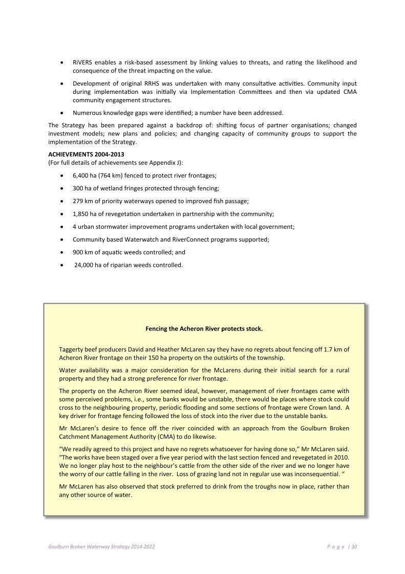
Goulburn Broken Waterway Strategy 2014-2022 P a g e | 30
• RiVERS enables a risk-based assessment by linking values to threats, and rating the likelihood and consequence of the threat impacting on the value.
• Development of original RRHS was undertaken with many consultative activities. Community input during implementation was initially via Implementation Committees and then via updated CMA community engagement structures.
• Numerous knowledge gaps were identified; a number have been addressed.
The Strategy has been prepared against a backdrop of: shifting focus of partner organisations; changed investment models; new plans and policies; and changing capacity of community groups to support the implementation of the Strategy.
ACHIEVEMENTS 2004-2013 (For full details of achievements see Appendix J):
• 6,400 ha (764 km) fenced to protect river frontages;
• 300 ha of wetland fringes protected through fencing;
• 279 km of priority waterways opened to improved fish passage;
• 1,850 ha of revegetation undertaken in partnership with the community;
• 4 urban stormwater improvement programs undertaken with local government;
• Community based Waterwatch and RiverConnect programs supported;
• 900 km of aquatic weeds controlled; and
• 24,000 ha of riparian weeds controlled.
Fencing the Acheron River protects stock.
Taggerty beef producers David and Heather McLaren say they have no regrets about fencing off 1.7 km of Acheron River frontage on their 150 ha property on the outskirts of the township.
Water availability was a major consideration for the McLarens during their initial search for a rural property and they had a strong preference for river frontage.
The property on the Acheron River seemed ideal, however, management of river frontages came with some perceived problems, i.e., some banks would be unstable, there would be places where stock could cross to the neighbouring property, periodic flooding and some sections of frontage were Crown land. A key driver for frontage fencing followed the loss of stock into the river due to the unstable banks.
Mr McLaren’s desire to fence off the river coincided with an approach from the Goulburn Broken Catchment Management Authority (CMA) to do likewise.
“We readily agreed to this project and have no regrets whatsoever for having done so,” Mr McLaren said. “The works have been staged over a five year period with the last section fenced and revegetated in 2010. We no longer play host to the neighbour’s cattle from the other side of the river and we no longer have the worry of our cattle falling in the river. Loss of grazing land not in regular use was inconsequential. “
Mr McLaren has also observed that stock preferred to drink from the troughs now in place, rather than any other source of water.

Goulburn Broken Waterway Strategy 2014-2022 P a g e | 31
Before and after images of rehabilitation works: Tahbilk Fish Passage, crossing modification (Simon Casanelia, GB CMA); Broken River, Flood Recovery (Geoff Brennan GB CMA); Goulburn River Recreational Fishing Licence project (Sue Kosch GB CMA); Broken River, bank protection (Geoff Brennan GB CMA).

Goulburn Broken Waterway Strategy 2014-2022 P a g e | 32
Figure 3-2: Location of river health works 2005 to 2013

Goulburn Broken Waterway Strategy 2014-2022 P a g e | 33
3 .8 P R OT ECT I NG T H E ECO L O GI C AL C HA RAC T ER O F T H E BAR M AH FO R E ST
The Barmah Forest Ramsar Site is located in northern Victoria and was designated under the Ramsar Convention in 1982. The site consists of a section of the River Murray floodplain between Ulupna Island and Barmah Township (Figure 3-3). It is predominantly River Red Gum (Eucalyptus camaldulensis) open forest and woodland and, along with the adjoining Millewa group of forests in NSW, forms the largest stand of River Red Gum in the world. It is also recognised as an Icon Site within The Living Murray program (MDBA 2011). It features alluvial fan-shaped deposits along the River Murray with ox-bows and meander scrolls as well as source-bordering dunes.
The Barmah Forest Ramsar Site supports a variety of wetland habitats, which vary from permanent lakes, billabongs and ponding effluents; through shallow basins with prolonged seasonal flooding. These support rushland or grassland communities in the wetter regions, through to gradational River Red Gum forest and woodland communities with a variety of vegetation understories. The site is declared National Park under the management of Parks Victoria and Yorta Yorta Nations Aboriginal Corporation. The key characteristics of the site and the wetland types present according to the Ramsar Convention classification system are shown in Table 3-3.
Figure 3-3: Location of Barmah Forest (Source: DEPI 2013c)

Goulburn Broken Waterway Strategy 2014-2022 P a g e | 34
Table 3-3: Summary of key characteristics of the Barmah Forest Ramsar Site (Source: Hale and Butcher 2011)
Area (Ha) Ramsar wetland type Land tenure Land Manager 29,516 ha (Source: RAMSAR_100 layer in DSE GIS Corporate Library)
N - Seasonal/intermittent/irregular rivers/streams/creeks O - Permanent freshwater lakes (over 8 ha); includes large oxbow lakes Ts - Seasonal/intermittent freshwater marshes/pools on inorganic soils; includes sloughs, potholes, seasonally flooded meadows, sedge marshes Xf - Freshwater, tree-dominated wetlands; includes freshwater swamp forests, seasonally flooded forests, wooded swamps on inorganic soils
Public Parks Victoria / Yorta Yorta Nations Aboriginal Corporation (co-management)
Barmah Forest Ramsar site meets six of the nine criteria for designating a Ramsar listed wetland as follows (Hale and Butcher 2011):
Criterion 1. A wetland should be considered internationally important if it contains a representative, rare, or unique example of a natural or near-natural wetland type found within the appropriate biogeographic region: Barmah Forest is part of the largest complex of tree-dominated floodplain wetlands in southern Australia. Barmah Forest, together with Millewa Forests (on the NSW side of the River Murray) is nationally the largest continuous stand of river red gum forest. The size and intact nature of this forested floodplain makes it clearly one of the best representatives of the wetland type Xf (freshwater tree-dominated wetlands) in the Murray-Darling Drainage Division. In addition, the site forms an extensive area of intact floodplain and is one of the few such areas with native vegetation in the bioregion.
Criterion 2. A wetland should be considered internationally important if it supports vulnerable, endangered, or critically endangered species or threatened ecological communities: Barmah Forest is a significant site in terms of supporting at least seven threatened wetland dependent species, listed at the national and/or international scale. These include Australasian Bittern (Botaurus poiciloptilus), Superb Parrot (Polytelis swainsonii), Mueller Daisy (Brachyscome muelleroides), Swamp Wallaby Grass (Amphibromus fluitans), Silver perch (Bidyanus bidyanus), Murray cod (Maccullochella peelii peelii) and Trout cod (Maccullochella macquariensis).
Criterion 3. A wetland should be considered internationally important if it supports populations of plant and/or animal species important for maintaining the biological diversity of a particular biogeographic region: Barmah Forest supports at least 553 native species of flora and 273 fauna (considerably more than some comparable sites in the bioregion). In addition, the site is bioregionally significant with respect to Moira Grass (Pseudoraphis spinescens) containing the only expanses (swards) of the species in the Murray-Darling Basin.
Criterion 4. A wetland should be considered internationally important if it supports plant and/or animal species at a critical stage in their life cycles, or provides refuge during adverse conditions: The Barmah Forest Ramsar site supports breeding of waterbirds, frogs, native fish and turtles during times of inundation. The site periodically supports thousands of colonial nesting waterbirds and is considered a drought refuge for waterbirds and native fish.
Criterion 5. A wetland should be considered internationally important if it regularly supports 20,000 or more waterbirds: Although there are only two confirmed records of more than 20,000 waterbirds from within the site, it is the opinion of local experts that total counts that included colonial nesting waterbirds as well as waterfowl and other solitary nesters, would number greater than 20,000 during floodplain inundation.
Criterion 8. A wetland should be considered internationally important if it is an important source of food for fishes, spawning ground, nursery and/or migration path on which fish stocks, either within the wetland or

Goulburn Broken Waterway Strategy 2014-2022 P a g e | 35
elsewhere, depend: The site provides migratory routes between habitat in the River Murray, anabranches and floodplains and is considered important for recruitment of native fish (King et al. 2007).
3.8.1 VALUES AND ECOLOGICAL CHARACTER OF BARMAH FOREST
The ecological character description for the site (Hale and Butcher 2011) identifies a number of ecosystem services and benefits (values) and physical, chemical and biological ecosystem components and processes that are considered critical to the ecological character of the Ramsar site (Table 3-4). The Barmah Forest is an important site for River Red Gums, which in turn provides services such as sheltering and nesting habitat for a range of species including bats, parrots, possums, snakes, and waterbirds.
The Ramsar site supports the most extensive area of Moira Grass plains in Victoria (Colloff et al. in press) which are significant breeding and feeding habitat for herons, spoonbills and marsh terns, large breeding colonies of Australian White Ibis and Straw-necked Ibis, as well as smaller colonies of egret species and spoonbill species.
The Ramsar wetland also contains many sites of cultural significance to Indigenous people, including occupation sites, burial grounds, mounds, middens, scarred trees and stone artefacts at many hundreds of sites. Barmah Forest is also on the Register of the National Estate in recognition of its heritage importance.
Contemporary social values are associated with recreation and tourism, education and interpretation, and scientific study. Economic values include recreation and tourism, timber production, stock grazing, apiculture, and extractive industries.
Where sufficient information exists, limits of acceptable change (LACs) have been developed for these critical components, processes and services. LACs are a tool for assessing when the character of a wetland may have changed. The current status of the critical services, components and processes of the Barmah Forest Ramsar site, based on the most recent formal assessment (Butcher et al. 2011) is also provided in Table 3-4.

Goulburn Broken Waterway Strategy 2014-2022 P a g e | 36
Table 3-4: Ecosystem services and benefits, components and processes, which are critical to the ecological character of Barmah Forest Ramsar Site (Hale and Butcher 2011) and current status (Butcher et al. 2011)
Critical components,
processes, benefits and
services
Description Current Status Does not
exceed Limits of Acceptable
Change
Exceeds Limits of
Acceptable Change
No Data/No Limits of
Acceptable Change
Hydrology • Inundation of the site is driven largely by flows within the River Murray.
• The hydrology of the site is highly regulated and seasonality of low and moderate flow is determined largely by irrigation needs.
• Large scale floods that inundate the forest are generally the result of catchment scale rainfall events.
• Groundwater may be important for maintaining tree health, but remains a knowledge gap.
X1
Vegetation • The two critical wetland vegetation categories are River Red Gum forests and floodplain marshes.
• Approximately 85% of the site is covered in inundation dependent forest and woodland (River Red Gum and Black Box), which has a combined extent of over 24,000 ha.
• River Red Gum forest is the dominant vegetation community, comprising 75% of the site.
• Floodplain marshes include Moira Grass (Pseudoraphis spinescens) plains (regionally significant), Giant Rush (Juncus ingens) beds, Common Reed (Phragmites australis) beds, moist grasslands, herblands and semi-permanent marshes.
• Supports two nationally threatened wetland flora species: Mueller Daisy (Brachyscome muelleroides) and Swamp Wallaby-grass (Amphibromus fluitans).
X2
Fish • Data deficient. • Seventeen native species of fish have been
recorded from within the site. • Results from surveys indicate that abundance
varies considerably and that invasive species generally comprise 10 to 30% of the total abundance and up to 70% of biomass.
• Supports three native threatened fish species: Silver perch (Bidyanus bidyanus), Murray cod (Maccullochella peelii peelii) and Trout cod (Maccullochella macquariensis).
X
Wetland birds • Sixty species of wetland bird have been recorded from the site. This includes seven species listed under international migratory agreements and two threatened species: Superb Parrot (Polytelis swainsonii) and Australasian Bittern (Botaurus poiciloptilus).
• Over 100,000 birds have been recorded in the site during times of flood.
• The site is significant for supporting breeding of colonial nesting waterbirds and contains a significant breeding population of Superb Parrot.
X
Diversity of wetland types
• The site supports part of the largest remaining River Red Gum forest and provides a mosaic of vegetated wetland habitats.
X

Goulburn Broken Waterway Strategy 2014-2022 P a g e | 37
Critical components,
processes, benefits and
services
Description Current Status Does not
exceed Limits of Acceptable
Change
Exceeds Limits of
Acceptable Change
No Data/No Limits of
Acceptable Change
Biodiversity • The site supports the regionally significant Moira Grass vegetation community and a significant number of plant and animal species.
X
Physical habitat • Barmah Forest Ramsar site provides habitat for feeding and breeding of wetland birds.
X
Threatened species
• The Ramsar site supports seven species listed under the EPBC Act and/or the IUCN Red List.
X
Ecological connectivity
• The Ramsar site provides important migratory routes between riverine, wetland and floodplain habitats for fish spawning and recruitment.
X
Organic carbon cycling
• As part of a major floodplain system, the site is important for the cycling of nutrients, particularly carbon both on the floodplain and as a source of organic carbon to receiving waterways.
X
1. There is evidence of a decline in small and medium floods in the past decade as a result of water use, prolonged drought and potential effects of climate change. The hydrology LAC for small (in-channel) and medium (overbank) flows have been exceeded (Hale and Butcher 2011).
2. No recent quantitative assessment, but extent of giant rush has expanded at the expense of Moira grass and it is possible the LAC for Moira grass has been exceeded (Hale and Butcher 2011).
3.8.2 THREATS TO THE VALUES OF BARMAH FOREST
The ecological character description identifies a number of threats to the values of the Barmah Forest Ramsar Site (Table 3-5). Of these, the most recent Ramsar Rolling Review (Butcher et al. 2011) identified water resource development, climate change and invasive species as the threats most likely to impact on ecological character of the Barmah Forest Ramsar site in the next ten years.

Goulburn Broken Waterway Strategy 2014-2022 P a g e | 38
Table 3-5: Summary of threats to the ecological character of the Barmah Forest Ramsar site (Hale and Butcher 2011)
Actual or likely threat or threatening activities
Potential impact(s) to wetland components, processes and/or service Likelihood 1 Timing 2
Water resource development (decreased frequency and duration of inundation; altered seasonality of inundation)
Reduced health and extent of River Red Gum forests and floodplain marshes. Altered vegetation community composition. Decreased habitat for fauna feeding and breeding. Absence or disruption of bird, fish and frog breeding events.
Certain Current
Climate change (increased temperatures and decreased rainfall).
Exacerbate effects of water resource development and altered fire regimes.
Certain Long-term
Altered fire regimes (increased frequency and intensity of fires)
Death of mature River Red Gums. Adverse changes to forest structure. Loss or degradation of habitat.
Medium Current
Invasive species (weeds, carp, horses)
Predation or competition with native flora and fauna. Increased risk of destructive wildfire through increased understorey biomass.
Certain Current
Human disturbance (recreation)
Loss or degradation of habitat through unauthorised firewood collection. Soil and riparian zone degradation by off road vehicles or watercraft. Increased risk of destructive wildfire.
Medium Current
1 Where Certain is defined as known to occur at the site or has occurred in the past; Medium is defined as not known from the site but occurs at similar sites; and Low is defined as theoretically possible, but not recorded at this or similar sites.
2 Where Current is defined as happening at the time of writing (2010); long-term is defined as greater than 10 years.
An Index of Wetland Condition (IWC) assessment was conducted for the Barmah Forest Ramsar Site at 30 representative plots in 2009. It concluded that while the overall condition of the Ramsar site was good, with 80% of plots assessed considered in “good” condition, hydrology was assessed as moderate or poor (Papas et al 2012). This reflects the long-term changes in hydrology as a result of river regulation, compounded by the long dry period from 1996 to 2009.
The level of risk posed to the assets within the Barmah Forest Ramsar Site is shown in Table 3-6.

Goulburn Broken Waterway Strategy 2014-2022 P a g e | 39
Table 3-6: Barmah Forest Ramsar Site – values, threats and risk assessment.
Type Attribute AVIRA score
(Barmah)
Altered Wetland
Form
Changed Water
Regime
Degraded Water Quality
Invasive Fauna
(Terrestrial)
Invasive Fauna
(Aquatic)
Invasive Flora
(Wetland)
Invasive Flora
(Riparian)
Reduced Wetland
Area
Soil Disturbance
Degraded Wetland
Buffer
Livestock Access to
Buffer 1 5 3 5 5 2 2 1 2 2 1
Envi
ronm
enta
l
Important Bird Habitat
5 High Risk (Reduce Threat)
Very High Risk
(Reduce Threat)
Moderate Risk
(Reduce Threat)
High Risk (Reduce Threat)
Low Risk (Reduce Threat)
High Risk (Reduce Threat)
Moderate Risk
(Reduce Threat)
High Risk (Reduce Threat)
Low Risk (Reduce Threat)
Moderate Risk
(Reduce Threat)
Low Risk (Protect)
Significant Birds
5 High Risk (Reduce Threat)
Very High Risk
(Reduce Threat)
Moderate Risk
(Reduce Threat)
High Risk (Reduce Threat)
Low Risk (Reduce Threat)
High Risk (Reduce Threat)
Moderate Risk
(Reduce Threat)
Moderate Risk
(Reduce Threat)
Low Risk (Reduce Threat)
Moderate Risk
(Reduce Threat)
Low Risk (Protect
Significant invertebrates
2 Very Low Risk (No Priority Action)
High Risk (Reduce Threat)
Moderate Risk
(Reduce Threat)
Low Risk (Reduce Threat)
Moderate Risk
(Reduce Threat)
Low Risk (Reduce Threat)
Very Low Risk
(Reduce Threat)
Very Low Risk
(Reduce Threat)
Low Risk (Reduce Threat)
Low Risk (Reduce Threat)
Low Risk (Protect)
Significant flora
5 Moderate Risk
(Reduce Threat)
Very High Risk
(Reduce Threat)
Low Risk (Reduce Threat)
Very High Risk
(Reduce Threat)
High Risk (Reduce Threat)
Very High Risk
(Reduce Threat)
Very High Risk
(Reduce Threat)
Moderate Risk
(Reduce Threat
Moderate Risk
(Reduce Threat)
Low Risk (Reduce Threat)
Low Risk (Protect)
Significant fish
5 High Risk (Reduce Threat)
Very High Risk
(Reduce Threat)
Very High Risk
(Reduce Threat)
High Risk (Reduce Threat)
Very High Risk
(Reduce Threat)
High Risk (Reduce Threat)
Moderate Risk
(Reduce Threat)
Low Risk (Reduce Threat)
Low Risk (Reduce Threat)
Low Risk (Reduce Threat)
Low Risk (Protect)
Significant amphibians
5 Moderate Risk
(Reduce Threat)
High Risk (Reduce Threat)
High Risk (Reduce Threat)
High Risk (Reduce Threat)
High Risk (Reduce Threat)
Moderate Risk
(Reduce Threat)
Low Risk (Reduce Threat)
Low Risk (Reduce Threat)
Low Risk (Reduce Threat)
Moderate Risk
(Reduce Threat)
Low Risk (Protect)
Significant wetland
vegetation
5 High Risk (Reduce Threat)
Very High Risk
(Reduce Threat)
Low Risk (Reduce Threat)
High Risk (Reduce Threat)
Moderate Risk
(Reduce Threat)
Very High Risk
(Reduce Threat)
Moderate Risk
(Reduce Threat)
Moderate Risk
(Reduce Threat)
Very High Risk
(Reduce Threat)
Moderate Risk
(Reduce Threat)
Low Risk (Protect)
Significant mammals
5 Low Risk (Reduce Threat)
Moderate Risk
(Reduce Threat)
Low Risk (Reduce Threat)
Moderate Risk
(Reduce Threat)
Very Low Risk
(Reduce Threat))
Low Risk (Reduce Threat)
Low Risk (Reduce Threat)
Low Risk (Reduce Threat)
Low Risk (Reduce Threat)
Low Risk (Reduce Threat)
Low Risk (Protect)
Significant aquatic reptiles
5 High Risk (Reduce Threat)
Very High Risk
(Reduce Threat)
Moderate Risk
(Reduce Threat)
Very High Risk
(Reduce Threat)
High Risk (Reduce Threat)
High Risk (Reduce Threat)
Moderate Risk
(Reduce Threat)
Low Risk (Reduce Threat)
Moderate Risk
(Reduce Threat)
Moderate Risk
(Reduce Threat)
Low Risk (Protect)

Goulburn Broken Waterway Strategy 2014-2022 P a g e | 40
Table 3-6 (continued): Barmah Forest Ramsar Site – values, threats and risk assessment.
Type Attribute AVIRA score
(Barmah)
Altered Wetland
Form
Changed Water
Regime
Degraded Water Quality
Invasive Fauna
(Terrestrial)
Invasive Fauna
(Aquatic)
Invasive Flora
(Wetland)
Invasive Flora
(Riparian)
Reduced Wetland
Area
Soil Disturbance
Degraded Wetland
Buffer
Livestock Access to
Buffer 1 5 3 5 5 2 2 1 2 2 1
Envi
ronm
enta
l (co
nt.)
Significant riparian reptiles
4 Low Risk (Reduce Threat)
Moderate Risk
(Reduce Threat)
Low Risk (Reduce Threat)
Very High Risk
(Reduce Threat)
Low Risk (Reduce Threat)
Low Risk (Reduce Threat)
Low Risk (Reduce Threat)
Low Risk (Reduce Threat)
Low Risk (Reduce Threat)
Low Risk (Reduce Threat)
Low Risk (Protect)
Significant EVC
(complex rating)
5 High Risk (Reduce Threat)
Very High Risk
(Reduce Threat)
Low Risk (Reduce Threat)
Very High Risk
(Reduce Threat)
Moderate Risk
(Reduce Threat)
High Risk (Reduce Threat)
High Risk (Reduce Threat)
Moderate Risk
(Reduce Threat)
Moderate Risk
(Reduce Threat)
Moderate Risk
(Reduce Threat)
Low Risk (Protect)
Drought refuge
5 Moderate Risk
(Reduce Threat)
Very High Risk
(Reduce Threat)
Very High Risk
(Reduce Threat)
Very High Risk
(Reduce Threat)
Very High Risk
(Reduce Threat)
High Risk (Reduce Threat)
High Risk (Reduce Threat)
Moderate Risk
(Reduce Threat)
Moderate Risk
(Reduce Threat)
Moderate Risk
(Reduce Threat)
Low Risk (Protect)
Soci
al
Tracks
5 No Risk (No Priority Action)
No Risk (Reduce Threat)
No Risk (Reduce Threat)
Very Low Risk (Reduce Threat)
Very Low Risk (Reduce Threat)
Very Low Risk (Reduce Threat)
Very Low Risk (Reduce Threat)
No Risk (Protect)
Low Risk (Reduce Threat)
Very Low Risk (Reduce Threat)
Low Risk (Protect)
Recreational Fishing
3 Very Low (No Priority Action)
Very high Risk (Reduce Threat)
Moderate Risk (Reduce Threat)
Low Risk (Reduce Threat)
Very high Risk (Reduce Threat)
Moderate Risk (Reduce Threat)
Moderate Risk (Reduce Threat)
Very Low Risk (Reduce Threat)
No Risk (Reduce Threat)
Very Low Risk (Reduce Threat)
Low Risk (Protect)
Swimming
3 No Risk (No Priority Action)
Very High (Reduce Threat)
Very Low Risk (Reduce Threat)
No Risk (Reduce Threat)
Low Risk (Reduce Threat)
Moderate Risk (Reduce Threat)
Moderate Risk (Reduce Threat)
Very Low (Reduce Threat)
No Risk (Reduce Threat)
Very Low (Reduce Threat)
No Risk (Protect)
Picnics and Barbeques
5 No Risk (No Priority Action)
Very Low Risk (Reduce Threat)
Very Low Risk (Reduce Threat)
No Risk (Reduce Threat)
No Risk (Reduce Threat)
No Risk (Reduce Threat)
Very Low Risk (Reduce Threat)
No Risk (Reduce Threat)
No Risk (Reduce Threat)
Very Low Risk (Reduce Threat)
Very Low Risk (Protect)
Sight seeing
3 Very Low Risk
(Reduce Threat)
Low Risk (Reduce Threat)
No Risk (Reduce Threat)
Low Risk (Reduce Threat)
Low Risk (Reduce Threat)
Low Risk (Reduce Threat)
Low Risk (Reduce Threat)
Low Risk (Reduce Threat)
Low Risk (Protect)
Low Risk (Protect)
Very Low Risk
(Protect)
Camping
4 Very Low Risk
(Reduce Threat)
Low Risk (Reduce Threat)
Low Risk (Reduce Threat)
Low Risk (Reduce Threat)
Low Risk (Reduce Threat)
Very Low Risk
(Reduce Threat)
Low Risk (Reduce Threat)
Very Low Risk
(Reduce Threat)
Low Risk (Protect)
Low Risk (Protect)
Low Risk (Protect)

Goulburn Broken Waterway Strategy 2014-2022 P a g e | 41
Table 3-6 (continued): Barmah Forest Ramsar Site – values, threats and risk assessment.
Type Attribute AVIRA score
(Barmah)
Altered Wetland
Form
Changed Water
Regime
Degraded Water Quality
Invasive Fauna
(Terrestrial)
Invasive Fauna
(Aquatic)
Invasive Flora
(Wetland)
Invasive Flora
(Riparian)
Reduced Wetland
Area
Soil Disturbance
Degraded Wetland
Buffer
Livestock Access to
Buffer 1 5 3 5 5 2 2 1 2 2 1
Soci
al (c
ont.)
Community groups
2 Low Risk (Reduce Threat)
Low Risk (Reduce Threat)
Low Risk (Reduce Threat)
Low Risk (Reduce Threat)
Low Risk (Reduce Threat)
Low Risk (Reduce Threat)
Low Risk (Reduce Threat)
Low Risk (Reduce Threat)
Low Risk (Reduce Threat)
Low Risk (Reduce Threat)
Low Risk (Protect)
Motor boating
3 Low Risk (Reduce Threat)
Low Risk (Reduce Threat)
Low Risk (Reduce Threat)
Very Low Risk
(Reduce Threat)
Low Risk (Reduce Threat)
High Risk (Reduce Threat)
Low Risk (Reduce Threat)
Low Risk (Reduce Threat)
No Risk (No Priority Action)
Very Low Risk
(Reduce Threat)
No Risk (Protect)
Non-motor boating
4 Moderate Risk
(Reduce Threat)
Moderate Risk
(Reduce Threat)
Low Risk (Reduce Threat)
Very Low Risk
(Reduce Threat)
Very Low Risk
(Reduce Threat)
High Risk (Reduce Threat)
Low Risk (Reduce Threat)
Low Risk (Reduce Threat)
No Risk (No Priority Action)
No Risk (No
Priority Action)
No Risk (Protect)
Firewood collection
3 Low Risk (Reduce Threat)
Low Risk (Reduce Threat)
Low Risk (Reduce Threat)
Very Low Risk
(Reduce Threat)
Very Low Risk
(Reduce Threat)
Very Low Risk
(Reduce Threat)
Low Risk (Reduce Threat)
Very Low Risk
(Reduce Threat)
Very Low Risk
(Reduce Threat)
Very Low Risk
(Reduce Threat)
No Risk (Protect)
Use of flagship species
5 Moderate Risk
(Reduce Threat)
Very high Risk
(Reduce Threat)
Very high Risk
(Reduce Threat)
High Risk (Reduce Threat)
Very high Risk
(Reduce Threat)
Very high Risk
(Reduce Threat)
Very high Risk
(Reduce Threat)
Moderate Risk
(Reduce Threat)
Low Risk (Reduce Threat)
Low Risk (Reduce Threat)
Moderate Risk
(Protect)
Park & reserve
Y High Risk (Reduce Threat)
High Risk (Reduce Threat)
Very Low Risk
(Reduce Threat)
Moderate Risk
(Reduce Threat)
Moderate Risk
(Reduce Threat)
Moderate Risk
(Reduce Threat)
Moderate Risk
(Reduce Threat)
High Risk (Reduce Threat)
Moderate Risk
(Reduce Threat)
Moderate Risk
(Reduce Threat)
High Risk (Protect)

Goulburn Broken Waterway Strategy 2014-2022 P a g e | 42
3.8.3 INFORMING MANAGEMENT OF BARMAH FOREST
The ecosystem services and benefits (values) and threats in the ecological character descriptions are considered in setting strategic priorities for the key regional management issues of environmental water (Chapter 4.3), floodplain management (Chapter 4.5), threatened species (Chapter 4.7), invasive species (Chapter 4.9), catchment management (Chapter 4.12) and climate change (Chapter 4.13). They are also aligned with values and threats used in the Aquatic Value Identification and Risk Assessment framework (Chapter 5) to inform priority setting for waterways in the region (Chapter 6), including the identification of priority management strategies.
There are a number of strategies and plans already in place for the management of the Barmah Forest Ramsar site. These include:
• Barmah-Millewa Forest Environmental Water Management Plan (MDBA 2012): under the Living Murray initiative, this plan describes ecological objectives for an area that includes the Barmah Forest Ramsar Site, and specifies watering regimes, works and water delivery arrangements to meet those objectives. Specifically ecological objectives and watering regimes are specified for the critical components of vegetation (River Red Gum and Moira Grass communities), native fish and breeding waterbirds.
• Environmental Water Delivery: Yarrawonga to Tocumwal and Barmah-Millewa (Ecological Associates and SKM 2011): developed for the Commonwealth Environmental Water Office to establish an operational framework for the delivery of environmental water to an area that includes the Barmah Forest Ramsar site to meet ecological objectives.
• Yorta Yorta NRM Management Plan (which includes the Barmah-Millewa Forest Ecosystem).
• Parks Victoria are developing a Horse Management Strategy (in progress).
• This Strategy seeks to integrate and co-ordinate management activities within the Barmah Forest Ramsar site with the long-term resource condition target to: “Maintain or improve the ecological character of the Barmah Forest Ramsar site”.
The Works and activities program for the Barmah Forest Ramsar site is shown in Table 3-7and in Chapter 7.
3.8.4 MONITORING RAMSAR SITES
The Australian Government Department of the Environment is developing a three-year Ramsar Rolling Review program for reporting the status of the ecological character of Australia’s Ramsar sites.
The broad aims of the Ramsar Rolling Review program are to:
• review and report on the status of the ecological character of Australia’s Ramsar sites (including positive or adverse change);
• be a tool to assist site management to maintain ecological character, improve links between ecological character, site management plans and monitoring programs for critical components, processes and services and associated threats;
• provide input to a database of baseline and threat data;
• record updates as knowledge gaps are addressed and refinement of LACs;
• highlight issues and facilitate assessment of a potential change of character, focussing on proactive management before the situation requires notification; and
• identify broad trends or common threats across site and jurisdiction boundaries.
Under the Ramsar rolling review, reporting for the Barmah Forest Ramsar site will focus on the LACs (refer to Table 3-6) but may also include critical components, processes or services where knowledge gaps exist (Table 3-7) or key threats as identified in the Barmah Forest Ramsar Site Ecological Character Description (Hale and Butcher 2011).

Goulburn Broken Waterway Strategy 2014-2022 P a g e | 43
The Ramsar site manager will be responsible for updating the Rolling Review database for the Barmah Forest Ramsar site every 3 years. Actions related to the monitoring requirements are described in Table 3-8 and Table 3-9. Monitoring is carried out under the Living Murray Program, as part of the management of the environmental water reserve (section 4.3) and the region’s waterway program.
Table 3-7: Works Program (Barmah Forest Ramsar site)
Management Unit Agricultural Floodplains
Basin Broken Wetland Barmah Forest Identification No.
60706 Values Important Bird Habitats (5), Significant EVCs (5), Camping (4), Motor Boating (4), Non-
Motor Boating (4), Picnics and Barbecues (5), Recreational Fishing (5), Sightseeing (5), Tracks (5), Significant Birds (5)
Threats Altered Hydrology Invasive Fauna, Invasive Fauna (Aquatic and Terrestrial)
Long-term Resource Condition
Maintain or Improve the Ecological Character of Barmah
Improve flow regime by 2021
Riparian and floodplain vegetation condition is maintained or improved by 2025
Management Outcome Targets Management Activity/Output Quantity Lead agency/partner
AF.38 Improved vegetation structure and diversity throughout reach
AF 38.1 Monitoring the Ecological Character of Barmah (Ramsar Site) and fill knowledge gaps.
1 Parks Victoria / GB CMA / DEPI (Region)
AF 38.2 Control invasive pest plant species (Aquatic: arrowhead)
1,000 ha
GB CMA / Parks Victoria / YYNAC
AF 38.3 Control invasive pest animal species (rabbit, fox, pig, horse)
500 ha
AF 38.4 Control invasive pest plant species (Terrestrial: willow, blackberry)
1,000 ha
AF.39 Increase community knowledge of site and program of works (progress)
AF 39.1 Co-ordinate engagement event, (Conference / field day)
5 (No.)
AF.40 Environmental water program will target altered hydrology threat score
AF 40.1 Management of flow releases - Deliver water to river reach at required timing
Based on seasonal watering plan (See Chapter 4.3)
DEPI / GB CMA / Fisheries NSW / VEWH (CEWH/MDBA)

Goulburn Broken Waterway Strategy 2014-2022 P a g e | 44
Table 3-8: Limits of acceptable change (LAC) and associated monitoring requirements for the Barmah Forest Ramsar site (adapted from Hale and Butcher 2011)
Critical components, processes and services Limit of Acceptable Change Monitoring requirements Priority for
monitoring
Hydrology
Minimum of 10,400 ML a day (River Murray at Yarrawonga) no less than seven years in any 10 year period, with a mean duration no less than 100 days; and a maximum interval of four years between the flow threshold.
Minimum of 16,000 ML a day (River Murray at Yarrawonga) no less than seven years in any 10 year period, with a mean duration no less than 90 days; and a maximum interval of four years between the flow threshold.
Minimum of 35,000 ML a day (River Murray at Yarrawonga) no less than 10 years in any 20 year period, with a mean duration no less than 60 days; and a maximum interval of 10 years between the flow threshold.
Minimum of 60,000 ML a day (River Murray at Yarrawonga) no less than 12 years in any 50 year period, with a mean duration no less than 21 days; and a maximum interval of 12 years between the flow threshold.
Continuous measurement of river flow in the River Murray at Yarrawonga.
High
Vegetation – River red gum forests and woodland
Extent vegetation to be no less than: • 19,350 ha of river red gum forest • 2,400 ha of river red gum woodland
River red gum condition to be “moderate” (according to the method of Cunningham et al. 2009) or better for at least 80% of forest.
Five-yearly mapping extent of River Red Gum communities in the Barmah Forest Ramsar site.
Annual surveys of river red gum condition.
Medium
Vegetation – Floodplain marshes
Extent of floodplain marshes to be no less than: • 1,350 ha of Moira grass • 450 ha of giant rush
Annual assessment of the extent and composition of floodplain marsh vegetation communities.
High
Vegetation – threatened species
Presence of Mueller Daisy (Brachyscome muelleroides) and Swamp Wallaby-grass (Amphibromus fluitans) in permanent and intermittent wetlands within the site.
Annual vegetation surveys. Medium

Goulburn Broken Waterway Strategy 2014-2022 P a g e | 45
Critical components, processes and services Limit of Acceptable Change Monitoring requirements Priority for
monitoring
Native fish (species richness)
Presence of the following species in no less than two in five annual surveys: • Australian Smelt (Retropinna semoni) • Carp Gudgeons (Hypseleotris spp.) • Dwarf Flat-headed Gudgeon (Philypnodon macrostomus) • Flat-headed Gudgeon (Philypnodon grandiceps) • Unspecked Hardyhead (Craterocephalus stercusmuscarum fulvus) • Murray-Darling Rainbowfish (Melanotaenia fluviatilis).
Annual fish composition and abundance at representative locations across the Ramsar site.
Medium
Native fish (threatened species)
Presence of Murray cod, Trout cod and Silver perch in three out of five of annual surveys. Annual fish surveys. Medium
Wetland birds (abundance)
Successful breeding (80% chicks fledged) of colonial waterbirds in at least five years in 10.
Thousands of colonial nesting birds in no less than two years in 10.
Flood event monitoring of breeding colonial nesting waterbirds and known breeding locations.
High
Wetland birds (threatened species)
Presence of Australasian Bittern when Tall Marsh is inundated.
Presence of Superb Parrot and evidence of breeding annually.
Bittern surveys in emergent vegetation wetlands during inundation events.
Annual surveys of Superb Parrots.
High

Goulburn Broken Waterway Strategy 2014-2022 P a g e | 46
Table 3-9: Knowledge gaps for the Barmah Forest Ramsar site (Hale and Butcher 2011)
Critical components, processes and services
Knowledge Gap Monitoring requirements
Hydrology Extent, frequency and duration of inundation for wetlands within the site benchmarked at the time of listing.
Regular flood inundation mapping.
Wetland vegetation – floodplain forests
The condition of forests at the time of listing.
Forest structure at the time of listing: tree age classes, coarse woody debris loads.
Continued monitoring of River Red Gum condition on an annual basis (including recruitment and age classes).
Wetland vegetation – floodplain marshes
The extent, community composition and condition of floodplain marshes at the time of listing. In particular, current extent of Moira grasslands within the site is a critical knowledge gap.
Annual monitoring of the extent and condition of floodplain marsh vegetation.
Native fish Species composition, use of off-stream habitats, variability across site.
Annual monitoring of fish community composition and abundance.
Wetland birds Quantitative data for waterbirds and nesting wetland birds.
Flood event monitoring of breeding colonial nesting waterbirds and known breeding locations.
Importance of the site for the endangered Australasian bittern.
Include Barmah Forest in the Birds Australia National Bittern Surveys (BA 2011).

Goulburn Broken Waterway Strategy 2014-2022 P a g e | 47
Challenges and Opportunities This Chapter:
Identifies the key strategic challenges and opportunities facing waterway management in the region.
Sets the framework and actions for priority strategic management issues.
The Strategy presents a high-level regional work program to guide investment over an eight-year period (see Chapter 7). It identifies and describes the major strategic opportunities and challenges facing waterway management in the region.
The Victorian Waterway Management Strategy (2013) details the statewide approach to key management issues and identifies statewide actions for implementation.
This Chapter outlines the background, principles, policies and actions for specific waterway management issues relating to identified opportunities and challenges4 within the Goulburn Broken region:
Chapter Challenge and Opportunity
4.1 Management of Riparian Land
4.2 Water Quality
4.3 Management of the Environmental Water Reserve
4.4 Groundwater
4.5 Floodplain Management
4.6 Public Infrastructure
4.7 Management of Threatened Aquatic Dependent Species
4.8 Management of Recreational Fisheries
4.9 Management of Invasive Species
4.10 Management of the River Channel
4.11 Management of Extreme Events
4.12 Influence of the Surrounding Catchment
4.13 Planning for Climate Change
4.14 Management and Use of Water Storages
4 It is acknowledged that many other challenges and opportunities could be considered within this Waterway Strategy; this is not an exhaustive list. The challenges and opportunities listed are considered to be a priority at the time of preparing this Strategy. However, within an adaptive framework, other challenges may be identified and addressed over the life of this strategy.

Goulburn Broken Waterway Strategy 2014-2022 P a g e | 48
4 .1 M A NAG E MEN T O F R I P AR I AN L AN D
The purpose of this Chapter is to provide strategic direction for the management of riparian land, which contributes significantly to the condition and resilience of values contained within waterway systems.
Riparian land adjoins waterways and its management has a significant impact on overall waterway condition. The capacity of riparian land to support a healthy waterway system and to contribute to supporting the values associated with adjacent land relies on its condition including the width, connectivity and structure of the vegetation present. Good riparian land contributes towards channel stability, supplies organic matter to waterways, filters light, filters pollutants from the surrounding catchment and contributes to the health and values of neighbouring land.
Riparian land also has a range of important values. The land is highly valued for production. It supports an array of threatened plant and animal species and is a site for recreation, tourism, cultural and heritage values.
In this Strategy, the objective for the management of riparian land is: To maintain or improve the resilience of riparian land as a key contributor to the condition and health of the region’s waterways. This Chapter explores how riparian land can be best managed towards this objective.
4.1.1 FUNCTIONS OF RIPARIAN LAND
Riparian land is important because it is often the most fertile and productive part of the landscape, in terms of both agricultural production and natural ecosystems. It often has deeper and better quality soils, and supports a higher diversity of plants and animals than the surrounding land. Many native plants are found only, or primarily, in riparian areas, and these areas are also essential to many terrestrial and aquatic animals for all or part of their lifecycle. Riparian land further provides important refuge during times of drought.
Riparian land supports many social, cultural, economic and environmental values we associate with our waterways.
4.1.2 RIPARIAN LAND OWNERSHIP AND MANAGEMENT
Riparian management should be seen as one part, albeit a very important part, of sound management at the property scale and at other larger scales, such as sub catchments and catchments. Even the best management of riparian land will not overcome management practices elsewhere that lead to excessive soil erosion, off-site loss of nutrients and other contaminants (Australian River Restoration Centre website).
A number of organisations and individuals are responsible for riparian land management in the Goulburn Broken region (See Table 4-1).
Victoria has a unique network of public riparian land known as Crown frontages (owned by the State), which were mostly established between the 1850s and the 1880s in recognition of their value as a public resource. Crown frontages occur mostly on larger waterways. Riparian land is usually privately owned on smaller waterways in agricultural landscapes. There are about 30,000 km of Crown frontages in Victoria of an estimated 85,000 km of rivers and creeks (therefore about 170,000 km of frontage).
About 22,000 km of Crown frontages are within cleared catchments (the other 8,000 km are in larger public land blocks such as parks and State forests). Crown frontage can vary from a few metres to kilometres wide, with the average width being about 20 to 40 metres. The total area of Crown frontage in Victoria is about 100,000 ha, which is only 0.4% of the State and 1.1% of the total public land estate. At present, about 17,000 km of the 22,000 km of Crown frontages within cleared catchments are managed by the adjacent landowner under about 10,000 agricultural licences. Most of the licences are for grazing purposes, with a small and diminishing number for the cultivation of crops. These licences are typically renewed every five years, with the next renewal scheduled for October 2014. The average licence fee is $85 for five years, calculated on productive value of the land but discounted based on weed management and other obligations on the licensee. (DEPI 2013b).
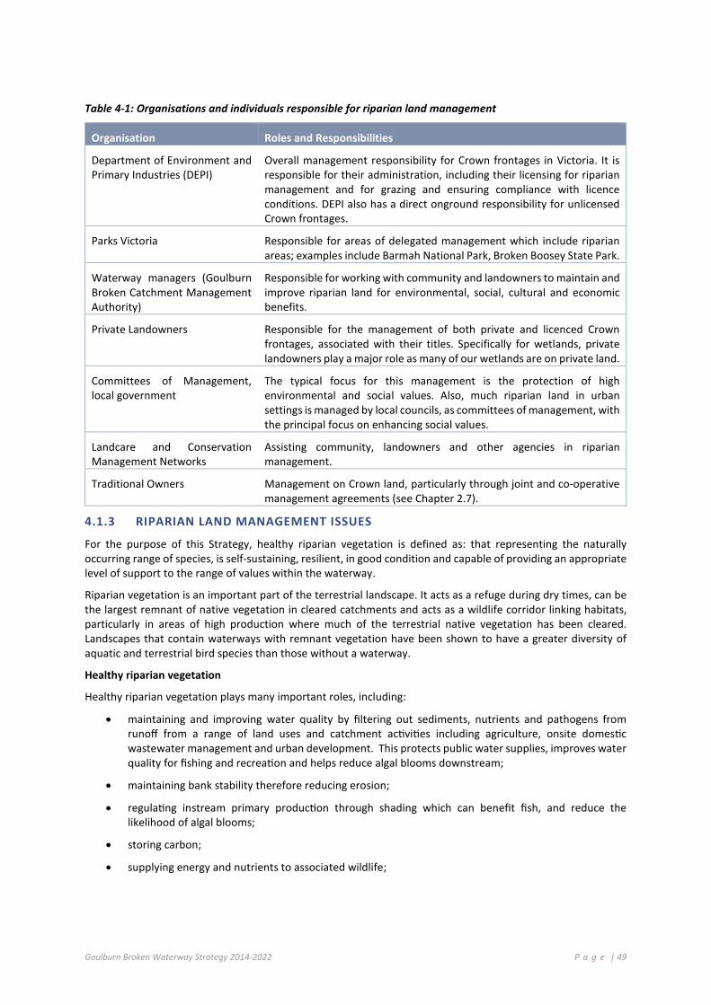
Goulburn Broken Waterway Strategy 2014-2022 P a g e | 49
Table 4-1: Organisations and individuals responsible for riparian land management
Organisation Roles and Responsibilities
Department of Environment and Primary Industries (DEPI)
Overall management responsibility for Crown frontages in Victoria. It is responsible for their administration, including their licensing for riparian management and for grazing and ensuring compliance with licence conditions. DEPI also has a direct onground responsibility for unlicensed Crown frontages.
Parks Victoria Responsible for areas of delegated management which include riparian areas; examples include Barmah National Park, Broken Boosey State Park.
Waterway managers (Goulburn Broken Catchment Management Authority)
Responsible for working with community and landowners to maintain and improve riparian land for environmental, social, cultural and economic benefits.
Private Landowners Responsible for the management of both private and licenced Crown frontages, associated with their titles. Specifically for wetlands, private landowners play a major role as many of our wetlands are on private land.
Committees of Management, local government
The typical focus for this management is the protection of high environmental and social values. Also, much riparian land in urban settings is managed by local councils, as committees of management, with the principal focus on enhancing social values.
Landcare and Conservation Management Networks
Assisting community, landowners and other agencies in riparian management.
Traditional Owners Management on Crown land, particularly through joint and co-operative management agreements (see Chapter 2.7).
4.1.3 RIPARIAN LAND MANAGEMENT ISSUES
For the purpose of this Strategy, healthy riparian vegetation is defined as: that representing the naturally occurring range of species, is self-sustaining, resilient, in good condition and capable of providing an appropriate level of support to the range of values within the waterway.
Riparian vegetation is an important part of the terrestrial landscape. It acts as a refuge during dry times, can be the largest remnant of native vegetation in cleared catchments and acts as a wildlife corridor linking habitats, particularly in areas of high production where much of the terrestrial native vegetation has been cleared. Landscapes that contain waterways with remnant vegetation have been shown to have a greater diversity of aquatic and terrestrial bird species than those without a waterway.
Healthy riparian vegetation
Healthy riparian vegetation plays many important roles, including:
• maintaining and improving water quality by filtering out sediments, nutrients and pathogens from runoff from a range of land uses and catchment activities including agriculture, onsite domestic wastewater management and urban development. This protects public water supplies, improves water quality for fishing and recreation and helps reduce algal blooms downstream;
• maintaining bank stability therefore reducing erosion;
• regulating instream primary production through shading which can benefit fish, and reduce the likelihood of algal blooms;
• storing carbon;
• supplying energy and nutrients to associated wildlife;

Goulburn Broken Waterway Strategy 2014-2022 P a g e | 50
• providing essential aquatic habitat through fallen logs, leaves and other plant material. For example, wood that falls into waterways can create deep holes and provides native fish protection from predation; and
• maintaining the integrity of the waterway through tree roots preventing undercutting of banks (ARRC web site, DEPI 2013b).
The ‘Index of Stream Condition’ (DEPI 2013a) has been used to assess 117 reaches in the Goulburn Broken catchment. Results from these assessments showed the entire range of indices for reach health from ‘reference’ (natural) condition to ‘poor’ condition. Overall, the majority of reaches (62% in both the Broken and Goulburn basins) were in good or excellent condition. Sixteen of the 117 reaches assessed across the region were in excellent condition, with the majority of these located in the Goulburn basin. Notably, reaches 63, 66 and 67-68 (on the Acheron, Rubicon and Big Rivers, respectively) in the heavily vegetated highlands of the Goulburn basin were in reference condition. The lowest and upper reaches of the Goulburn, Dabyminga, Yea, Murrindindi, Taggerty, Howqua and Delatite rivers were in near reference condition (reaches 1, 15-16, 50, 57, 59, 64, 70 and 72, respectively).
The health of reaches reflected associated land use, with reaches in reference condition located in the reserves and uncleared land in the south of the catchment and those in poor condition located where associated riparian and surrounding land had been cleared. For further information see: Third Index of Stream Condition report or http://bit.ly/1pzSFm6 (DEPI, 2013a).
Weeds
Weeds are an important management issue because they displace native species and affect both the biological and physical processes of ecosystems. Single species can dominate riparian land reducing biodiversity and the associated native animals because weeds modify and usually reduce habitat opportunities.
Different weed species have different impacts. For example, highly invasive transformer species, e.g. Broom, Blackberries, Tree Willows and Shrub Willows, often form dense infestations, and have significant impacts on many ecosystem processes, such as provision of habitat and natural regeneration of native species. Scrambling species have the potential to severely affect the growth and health of native vegetation (e.g. Cape Ivy and English Ivy) by smothering native plants and trees. In contrast, other species such as some flatweeds and Yorkshire Fog rarely form dense infestations in riparian areas and generally appear to have comparatively less impact on biological and physical processes; although it is important to note that such species may be more problematic in other ecosystems.
Riparian areas are particularly susceptible to weed invasion and are often invaded by multiple weed species. This susceptibility to invasion is a result of the natural disturbance processes associated with flooding, favourable environmental conditions and the continued input of weed propagules from upstream and surrounding land. The impacts of human activities have also increased the likelihood of weeds establishing in riparian areas, which often have a higher edge to area ratio making them more vulnerable to invasion. Despite the challenges, well designed weed management programs can achieve positive outcomes in riparian areas (Ede and Hunt 2008).
Weeds in riparian areas may:
• change vegetation community composition;
• inhibit recruitment and growth of native plant species;
• decrease food and habitat for native fauna, both terrestrial and aquatic;
• change aquatic food webs;
• provide food and habitat for exotic animals such as foxes and blackbirds;
• change soil nutrient processes;
• decrease water quality;
• change sedimentation, erosion and hydrological processes;
• decrease water quantity (e.g. willows);

Goulburn Broken Waterway Strategy 2014-2022 P a g e | 51
• change water temperature and light conditions by overshading the waterway; and
• reduce access and recreational opportunities (Ede and Hunt 2008).
Land managers are currently required to manage certain pest plants and animals on private riparian land and through licence conditions for Crown frontages under the Catchment and Land Protection Act 1994. These include the pest plant species Blackberries, Willows and Desert ash.
Willows
Willows are now regarded as one of the most serious riparian weeds in Australia and are listed as one of Australia’s 20 Weeds of National Significance (Holland Clift & Davies 2007). In decades past willows were used in waterway management to combat bank erosion. It is now understood that the negative impact of willows in and along waterways far outweighs any positive values.
Willows are considered a serious weed in a number of parts of the catchment particularly along the upper Goulburn River and tributaries, the mid Broken River, Holland and Ryans creeks.
Willow impacts in waterways includes:
• increased erosion and flooding;
• reduced quality and flow of water;
• reduced availability of water;
• less habitat available for fish, birds, frogs, insects, mammals and reptiles;
• obstructing access to streams for fishing and aquatic activities; and
• damage to nearby infrastructure (Holland Clift & Davies 2007).
For further information see http://www.weeds.org.au/WoNS/willows/
The GB CMA will work in a voluntary and co-operative approach with landowners to manage weeds including willow and blackberry infestations to improve the condition of the region’s waterways.
Stock and waterways
Stock access can have a detrimental impact on waterway condition and present risks to human health through reduced water quality. Impacts include:
• soil pugging and reducing grass cover, resulting in increased sediment and nutrient runoff to a waterway;
• restricting regeneration of native vegetation, reducing its ability to maintain waterway health;
• increased erosion;
• reduction in habitat for native fauna;
• soil compaction; and
• increased weed invasion into riparian land.
Restricting stock access to waterways can have many landowner benefits. These include:
• reduced erosion;
• reduced stock losses;
• controlled water quality for livestock which may improve stock health;
• improved stock manageability; and

Goulburn Broken Waterway Strategy 2014-2022 P a g e | 52
• benefits to the broader community through reduced pollution in waterways, downstream of the stock access area.
For further information see: Stock and Waterways: A Managers Guide (Land & Water Australia)
Research has shown that stock accessing waterways upstream of drinking water offtakes possess a significant risk to human health. The Victorian Department of Health commissioned a report to look at this issue which found there is a significant risk in allowing stock access.
For a full report (Public health issues associated with stock accessing waterways upstream of drinking water offtakes) see: http://www.health.vic.gov.au/water/drinkingwater/protecting-our-drinking-water-catchments
The GB CMA will work with water authorities and landowners in a voluntary but targeted approach to reduce stock access to waterways upstream of drinking water offtakes.
Controlled grazing
Fencing to restrict or control grazing results in the issue of stock gaining access to water. A private frontage or traditional Crown frontage licence allows stock direct access to the stream or river as a source of water. However, if landowners hold a riparian management licence and the area is fenced to prevent stock access to the waterway, a take and use licence is available from Goulburn-Murray Water to access water for stock (if the land manager does not already have a take and use licence or the volume of the existing water licence is not adequate for the stock’s water needs). In this case, water does not need to be purchased on the water market, but an application fee and annual renewal fee may apply. Grants are available for assistance in funding alternative water supplies.
For further information see: Stock and Waterways: A Managers Guide (Land & Water Australia) and http://www.depi.vic.gov.au/water/rivers-estuaries-and-wetlands/implementation-and-monitoring/managing-grazing-on-riparian-land.
The GB CMA will work with landowners who want to improve the condition of their frontage and establish a specific controlled grazing regime relevant to their frontage where appropriate.
Water licence fees are now reduced for farmers who fence off Crown land along rivers to manage stock access as part of riparian management projects conducted with CMAs.
Landowners whose land abuts a Crown frontage and who apply for a new take and use licence for stock water will now be reimbursed for their application fee. From 1 November 2013, their annual fee will be waived for three years and they will be given a longer licence period saving up to $2,100.
CMAs will now pay the cost of the initial application fee back to landowners to encourage more farmers with Crown frontages to sign up to works like fencing, revegetation and off-stream stock watering which will provide flow-on environmental benefits (see http://www.depi.vic.gov.au/water/rivers-estuaries-and-wetlands/implementation-and-monitoring/take-and-use-licences).
Where landowners have fenced off an existing licenced Crown frontage (and transferred the licence to a riparian management licence) the GB CMA will facilitate a process with GMW to obtain a licence and volume for stock water
Please note: some ongoing costs will be need to be borne by the landowner

Goulburn Broken Waterway Strategy 2014-2022 P a g e | 53
Bushfire
A common misconception is that riparian land in good condition or well vegetated riparian areas pose a significant bushfire risk. These areas actually pose a lower bushfire threat to assets than the threat posed by other parts of the landscape (DEPI 2013b). Well vegetated riparian land retains moisture and provides fire refuge areas for wildlife.
Statewide policy relating to bushfire and riparian land management described in Chapter 9.3.1 of the VWMS. (DEPI 2013b)
Access to riparian areas for recreation
Nearly half (4,760 km), of the approximate 10,000 km of streams in the Goulburn Broken region are abutted by Crown frontage. Where a Crown frontage exists, the public has the right to enter and remain on the land for certain recreational purposes such as walking, fishing or bird watching. Members of the public should not interfere with the purpose of any licenced frontage and are not permitted to camp or light fires on licenced Crown frontages.
Environmental and productivity benefits of good management
Good management of riparian areas can have positive environmental, social and productivity benefits. One way to plan well for multiple benefits at the property scale is to develop a Whole Farm Plan (refer to Chapter 4.12.3).
Production benefits include: management of grazing; access to water for stock; maintain channel stability; shelter belts; management of pests (through wildlife); stock management; and property values.
Environmental benefits include: protection of threatened species (flora and fauna); carbon sequestration; protection of water quality; and maintenance of channel stability.
Social benefits include: improved drinking water quality; public access; aesthetics; recreation and tourism; cultural and heritage values; and maintenance of channel stability.
Partnering with landowners to improve condition
The VWMS outlines the statewide approach to improved riparian management and discusses the need for voluntary and co-operative partnerships between landowners and government agencies. The GB CMA will assist in improving riparian management by providing information and investment for the improvement of riparian condition.
Typical management activities that can be supported by GB CMA investment assistance include:
• Fencing to remove uncontrolled stock grazing on riparian land. Under statewide policy such government investment is applied where fencing “will aim to be at least 20 metres wide on average from the top of the bank and must not be narrower than 10 metres any one place”;
• Revegetation or natural regeneration, through practices such as tube stock planting, direct seeding and management that allows natural regeneration;
• Pest plant and animal management. Landowners are currently required to manage certain pest plants and animals on private riparian land and through licence conditions for Crown frontages under the Catchment and Land Protection Act 1994.
• Off stream watering infrastructure; and
• Mechanisms relating to wetlands and riparian land often involve revegetation and protection of private land through tools such as Market Based Instruments, land swaps, management agreements and covenants.
State Government investment in riparian management (DEPI 2013b, d) will target priority activities that will identify high value waterways and establish priority riparian management activities as determined through this Strategy (see Chapter 7). It is also important to align the management action with the key threats and threatening process (GHD 2012) and Chapter 6.7.

Goulburn Broken Waterway Strategy 2014-2022 P a g e | 54
Riparian Management Agreements
Partnering with landowners will involve voluntary riparian management agreements (for Crown and private land) and licence arrangements with (adjoining) landowners. These agreements will be legally binding and set out management actions and responsibilities.
Riparian Management Licences
A riparian management licence for a Crown frontage recognises that all or part of the frontage is being managed by a licensee to maintain or improve the riparian environment (e.g. fenced out and supporting native vegetation). A riparian management licence is typically generated through the conversion of an existing grazing licence as part of an agreement between a landowner and the GB CMA for undertaking riparian protection and improvement works such as fencing and revegetation. The long-term management responsibilities agreed to by the landowner in the CMA agreement are incorporated as special conditions into a riparian management licence. These special conditions remain with the licence which may be transferred if the adjacent private land changes hands. Licences are generally renewed every five years. Many projects on Crown land that include fencing to manage stock access to a waterway qualify for a riparian management licence e.g. CMA, Landcare or privately funded projects (DEPI 2013b).
The GB CMA will work in a voluntary and co-operative approach to change licence agreements with landowners who undertake activities to improve the resilience of the region’s priority riparian lands.
4.1.4 PRIORITY ACTIONS FOR RIPARIAN MANAGEMENT
The following table details priority actions; the timeframe for implementation and the responsible agency, authority or group:
Action Timeframe Responsibility
Undertake strategic revegetation and associated riparian works such as fencing, weed management and the provision of off-stream stock watering infrastructure on priority waterways, wetlands and floodplains to maintain and improve the resilience of targeted waterways.
2014-2022 GB CMA, Landowners
Link strategic land management actions to key (priority) riparian management programs within areas that contribute to waterway resilience.
2014-2022 GB CMA, DEPI (region), Landcare and Landowners

Goulburn Broken Waterway Strategy 2014-2022 P a g e | 55
4 .2 W A T E R QU AL I T Y
Development of the Goulburn Broken Water Quality Strategy (WQS) commenced in 1994. The WQS aimed to reduce potential catchment Total Phosphorus (TP) loads exported from the catchment by 65% (from an estimated 371t of TP) to reduce the risk and incidence of blue green algal events. Implementation began in 1996 and a review of the Strategy and its implementation was commissioned in 2007. Overall, a substantial reduction in TP export from the catchment has been achieved. Analyses of trends generally show improving or stable water quality conditions. The review highlighted “new” issues to be addressed including climate change impacts on water quality. Implementation of the Strategy improves the resilience of the catchment’s streams and water bodies.
4.2.1 REVIEW PROCESS
The 2007 review of the Goulburn Broken Water Quality Strategy (1996), commissioned by the GB CMA was conducted by Feehan Consulting (2008). The initial strategy had been implemented for a decade and new water quality issues were emerging.
The Water Quality Strategy (1996) aimed, “to improve and maintain water quality at optimum levels within and downstream of the catchment for native ecosystems, recreation, human and animal consumption, agriculture and industry."
The first step in this review process was an examination of the outcomes from community efforts towards the goals stated in the Strategy. It was not a detailed review exercise.
A further review was undertaken in 2010 that underwent a detailed assessment of the Strategy’s performance. The review identified new water quality issues for the community to focus on: pathogens, sedimentation, impacts of catastrophic events and impacts of development pressure.
The current aim is “to maintain and improve water quality for the range beneficial uses (values).”
Regional partnership agreement for managing water quality incidents in the
Goulburn Broken region
A partnership agreement for managing water quality incidents was established in 2007 by key agencies with regulatory or functional responsibilities for waterways in the Goulburn Broken region. The ‘Partnership Agreement for Preparedness and Response to Waterway Incidents in the Goulburn Broken Catchment’ clearly outlines roles and responsibilities for responding to regional waterway incidents and is signed by the Department of Sustainability and Environment, the Environment Protection Authority Victoria, the Goulburn Broken Catchment Management Authority, Goulburn-Murray Water, Goulburn Valley Region Water Corporation, North East Region Water Corporation and the Department of Health.
The agreement provides a regional framework for response and recovery from waterway incidents that are not covered by existing arrangements. The intent of the agreement was to clearly establish the framework for leadership, and provide guidance in operations, communications and investigation of waterway incidents. This was considered essential to ensure a co-ordinated approach and to maintain the confidence of the community while all agencies carry out their respective roles in protecting, restoring and maintaining water quality of waterways.
In support of the agreement, a Water and River Contingency Planning Group was also established for the region that considers a range of waterway and water quality issues, including fish death incidents. This group meets on a regular basis throughout the year, and more frequently when risks to waterways increase.
The agreement has provided useful guidance during dry inflow conditions (that were experienced during the drought) and for managing water quality incidents such as low dissolved oxygen, blackwater and fish deaths that were caused by regional flooding.

Goulburn Broken Waterway Strategy 2014-2022 P a g e | 56
4.2.2 LESSONS LEARNED
A number of key lessons have emerged from the WQS implementation process:
• understanding and involvement of key sectors of the community and industry was critical in strategy preparation and implementation;
• working out what is important; our process helped determine the key issues (in the case study areas and nutrient management);
• working with imperfect knowledge; these processes never have perfect knowledge. We had to state our assumptions and move on. We have been able to test our assumptions over time and many have been monitored and proven adequate;
• availability of data; the Goulburn Broken catchment is considered “data rich”, but even so, data was not available to investigate all questions. We could not wait for data to become available on all topics;
• target setting is an imperfect process. Our approach of setting targets is based on best management practices (BMPs) and worked well for us;
• monitoring of water quality parameters is relatively straight forward. Monitoring of BMP implementation is very difficult; and
• integration with other programs; achieving implementation by integrating with other programs already established in the catchment has worked well and reduced overlap and duplication and increased investment.
4.2.3 BASIN SALINITY MANAGEMENT STRATGY
The Murray-Darling Basin Salinity Management Strategy guides communities and governments in working together to control salinity whilst protecting key natural resource assets across the Murray-Darling Basin. The Basin Salinity Management Strategy builds on the success of the 1989 Salinity and Drainage Strategy (MDBA, 2014).
Onground salinity management is largely achieved through activities being implemented at a local, state and territory level.
The objectives of the Murray-Darling Basin Salinity Management Strategy (MDBA 2014) are:
• maintain water quality of the Murray and Darling Rivers for agricultural, environmental, urban, industrial and recreational use;
• monitor and manage salt loads in all tributary rivers of the Murray–Darling Basin;
• manage land degradation through protecting important terrestrial ecosystems, productive farm land, cultural heritage and built infrastructure; and
• maximise net benefits resulting from salinity management across the Basin.
4.2.4 IMPLEMENTATION
Development of an integrated and co-ordinated water quality strategy for the Goulburn Broken catchment has been completed and implementation is progressing. Substantial reductions of nutrient outputs from major sources have been achieved, but it is too early to determine whether objectives are being met or will continue to be met.
However, the Goulburn Broken WQS is considered, by the Regional Water Quality Forum, the correct approach for delivering improvement in water quality (nutrients) within the region.

Goulburn Broken Waterway Strategy 2014-2022 P a g e | 57
The Goulburn Broken Water Quality Co-ordination Group
The Goulburn Broken Water Quality Co-ordination Group aims to ensure all relevant partners understand what is being achieved and how their component and activities fit towards achieving water quality goals for the region. The meetings provide a mechanism for regional consideration of relevant issues. The group focuses, at a strategic level, on: technical and science issues, communication and facilitation, co-ordination and information sharing and aligning activities to relevant strategies.
The region has also established a Regional Water and Contingency Planning Group that assesses risks and responds to waterway incidents.
Members of the above groups include (not limited to): the Goulburn Broken Catchment Management Authority; Goulburn-Murray Water; Goulburn Valley Region Water Authority; North East Region Water Authority; local government; Waterwatch; Northern Regional Water Monitoring Partnership; Department of Health; Department of Environment and Primary Industry; and Environment Protection Authority Victoria.
4.2.5 STRATEGIC APPROACH
The recommended strategic approach to water quality management includes:
• involvement of the community in water quality issues (planning, implementation and monitoring);
• implementation of an adaptive management approach and measure the change in resilience;
• determine, understand and address the key issues;
• advance our knowledge in general including potential impacts of climate change;
• continue to improve our knowledge base (data, risks, adaptive management);
• use best available data and knowledge and acknowledge that this could be imperfect;
• set and monitor appropriate targets;
• integrate water quality activities with other programs and stakeholders (agencies and community) via partnership approaches; and
• maintain sufficient investment.
4.2.6 STRATEGIC PRIORITIES
The Goulburn Broken Water Quality Co-ordination Group completed a review of strategic priorities in mid-2012. Strategic priorities are shown in Table 4-2.
The Group assessed regional water quality issues with the aim of developing a works program to be addressed by the Group, and their respective organisations, over time.

Goulburn Broken Waterway Strategy 2014-2022 P a g e | 58
Table 4-2: Strategic Priorities (2012)
Strategic Priority Why it is a priority What is the key Action to be done? Land Development and Planning Sewerage Scheme Planning/ On site Waste Water Management
Source of human infectious organisms (pathogens). Source of sediment and turbidity and nutrients.
Development, implementation and monitoring of domestic wastewater management plans across the region. Assess priority development zones for their impact on beneficial uses. Ensure adequate sewerage management (demand/need) strategies exist to for existing townships and development areas. Assess impacts of diffuse sources across the region and develop risk assessment and mitigation activities for beneficial uses. Ensure effective use of existing planning controls and implementation of “best practice”.
Partnerships A means of managing water quality issues in the catchment.
Maintain and support Regional Water Quality Forum and River and Water Contingency Planning Group (Waterway Incidents). Support Northern Water Monitoring Partnership.
Source and Fate of Pollutants Helps us understand how pollutants are sourced, transported and can be managed.
Assess the risk posed to beneficial uses (surface and subsurface) from key pollutants (pathogens, nutrients, sediments). Develop and implement programs to address high risk areas and pollutants. Maintain links with research providers.
Riparian Land Management
Riparian land can be a source of pollutants (especially sediment, turbidity and human infectious organisms).
Accelerate the level of riparian management “best practice” initiatives.
Support Policy 9.6 from the Victorian Waterway Management Strategy (2013), which relates to addressing pathogen risks from stock accessing waterways upstream of drinking water offtakes.
4.2.7 PRIORITY ACTIONS FOR WATER QUALITY
The following table details priority actions; the timeframe for implementation and the responsible agency, authority or group:
Action Timeframe Responsibility Development of domestic wastewater management plans across the region. 2015 OLV, DEPI, Local
Government Development, implementation and monitoring of domestic wastewater management plans across the region.
2016-2022 OLV, DEPI, Local Government
Continue to support “Waterwatch” within the region. 2015-2022 GB Water Quality Forum
Maintain and support Northern Regional Water Monitoring Partnership and River and Water Contingency/Planning Group.
2014-2022 All
Assess the risk posed to beneficial uses (surface and subsurface) from key pollutants (pathogens, nutrients, sediments).
2014-2022 GB CMA (Waterway Manager)
Assess pathogen risks from stock accessing waterways upstream of drinking water offtakes, as part of riparian management programs, in line with Policy 9.6 of the Victorian Waterway Management Strategy (2013).
2016 GB CMA

Goulburn Broken Waterway Strategy 2014-2022 P a g e | 59
4 .3 M A NAG E MEN T O F T HE EN VI RO N MEN T A L W A T E R RE S ER V E
Environmental water management aims to restore components of natural flow regimes in rivers and watering regimes in wetlands to maintain and improve their resilience. Natural flow and watering regimes have been heavily impacted by river regulation and water consumption, and by artificial barriers that reduce wetland access to natural sources of water.
Environmental water management has developed substantially during the life of the 2004 Goulburn Broken River Health Strategy. A number of plans and strategies have been prepared to support policy initiatives: the 2009 Northern Victorian Sustainable Water Strategy, the Commonwealth Water Act 2007, and the 2012 Basin Plan. Environmental water holders have been established by the Victorian and Commonwealth governments, and the GB CMA has been designated as the manager of environmental water in this catchment. The Environmental Water planning process is shown in Figure 4-1.
Policy and administrative arrangements will continue to evolve with the implementation of the Basin Plan through the life of this Strategy.
Initially, the only managed environmental water5 was 500,000 ML for Barmah Forest, and 27,500 ML for all Northern Victorian wetlands. In the Goulburn system, there is now an additional 265,000 ML of High Reliability Water Shares and 169,000 ML of Low Reliability Water Shares, with similar amounts held in the Victorian Murray supply system. These water entitlements are adequate to meet some or all of the currently identified environmental flow components. However, the Basin Plan currently requires greater volumes to be acquired to provide for all the environmental needs throughout the Murray-Darling Basin.
With significant volumes of environmental water available, environmental flows are now routinely being planned and managed in the Barmah Forest, the lower Goulburn River, the lower Broken Creek, the upper Broken Creek, and various wetlands. This is managed through the Annual Watering Plan process.
5 The amounts delivered are not the full amount of water available to the system.

Goulburn Broken Waterway Strategy 2014-2022 P a g e | 60
Figure 4-1: The Environmental water planning process (from DEPI 2013b)
4.3.1 PRIORITY WATERWAYS
Barmah Forest, a Ramsar-listed wetland system on the River Murray floodplain, has extensive red gum forests and wetlands providing critical habitat for waterbirds, fish, and a range of other animals. It has much reduced winter/spring flooding flows, and has frequently low level summer-autumn flooding.
The lower and mid Goulburn River and its associated floodplain and wetland habitats support intact river red gum forest, and numerous threatened species such as Murray cod, Trout cod and Macquarie perch.
The lower and mid Goulburn River is the most flow altered stream in the catchment due to water harvesting and water delivery for irrigation. It has two key reaches. The first is between Lake Eildon and Goulburn Weir (Reach 9-14, ISC) where summer flows are high (and usually cold water) and winter flows are lower. The second is between Goulburn Weir and the River Murray (Reach 1-8, ISC) where both summer and winter flows are reduced. Summer flows would be low with higher temperatures under natural conditions throughout both reaches and winter-spring flows would be naturally higher.
Lower Broken Creek is a highly modified natural waterway with significant environmental values including large bodied native fish, and severe water quality problems (low dissolved oxygen and azolla blooms).

Goulburn Broken Waterway Strategy 2014-2022 P a g e | 61
Wetlands, both along watercourses and isolated on the riverine plains have a variety of environmental values, and are also priorities for improved flow management.
Several unregulated streams throughout the catchment are also priorities, although active flow management is not possible, as there are no upstream storages where water can be accessed and delivered. Flow management in unregulated systems can be actively managed through managing the diverters, (Stream Flow Management Plans, rostering, local management rules, etc.). Published local management rules for unregulated streams across the Goulburn Broken that sets out flow restrictions, and roster arrangements on unregulated systems can be found on the Goulburn-Murray Water website: www.g-mwater.com.au.
4.3.2 MANAGEMENT OBJECTIVES
Management objectives have been set for all priority waterways. Environmental flow studies have been completed for the Goulburn River, the Broken River, the upper and lower Broken Creek, Seven Creeks, Yea River and King Parrot Creek. Wetland Management Plans are available for all priority wetlands, including Barmah Forest, Reedy Swamp, Black Swamp, Kinnairds Wetland, Moodie Swamp, Doctors Swamp, Gaynor Swamp, One Tree Swamp, Two Tree Swamp, Wallenjoe Swamp, and Mansfield Swamp.
4.3.3 STRATEGIC PRIORITIES
Given that environmental water has become available for use and the ongoing implementation of the Basin Plan, the key focus for environmental water management will continue to be the regulated water supply systems and the environmental assets that can be supplied from them.
The continued development and updating of management frameworks, practices and capabilities are key priorities.
Adaptive management, based on applying environmental water and understanding the outcomes from its use, will be critical for building knowledge to maximise the long-term benefits.
Community understanding of and involvement in environmental water management will improve the development of long-term environmental water management.
It is also important that unregulated systems are managed though the development of management rules, environmental flow studies and management of diverters.

Goulburn Broken Waterway Strategy 2014-2022 P a g e | 62
4.3.4 PRIORITY ACTIONS FOR ENVIRONMENTAL WATER RESERVES
The following table details priority actions; the timeframe for implementation and the responsible agency, authority or group:
Action Timeframe Responsibility
Support development of environmental monitoring and research programs focused on key environmental watering priorities (including wetland vegetation), and establish processes to routinely assess results and feed back into future flow management decisions.
2018-2021 DEPI, GB CMA, VEWH, ARI, Universities
Redevelop river health and environmental flow objectives for the Goulburn River between Lake Eildon and Goulburn Weir (to accommodate high summer flows and cold water).
2014-2021 GB CMA
Develop Environmental Water Management Plans for the Goulburn River, upper and lower Broken Creek.
2014-2018 GB CMA
Develop a multi-year environmental flow planning framework for the Goulburn River, including compatibility with River Murray environmental flow release needs from the Goulburn River.
2014-2021 GB CMA, VEWH
Develop an understanding of the issues associated with lower Goulburn floodplain watering to develop options for maximising environmental outcomes while minimising social and economic impacts.
2014-2018 GB CMA, DEPI, VEWH
Develop and implement works and other actions to provide water supply to priority wetlands and streams (e.g. regulators).
2014-2021 GB CMA, DEPI
Understand the potential impacts of environmental flow management on economic and social activities, and minimise impacts where possible.
2016-2021 GB CMA, VEWH GMW, DEPI (policy), RMW Work with GMW and River Murray Water to maximise the potential
environmental outcomes from management of consumptive water en-route and supply system operation flexibility. Increase community communication and engagement in environmental flow management. Develop a better understanding of groundwater dependent ecosystems and look for opportunities to maintain and improve these. Continue to develop and implement strategic actions at Barmah Forest. Undertake planning to address delivery constraints and to advocate for over-bank environmental flows.
2014-2022 GB CMA, VEWH, DEPI
4 .4 G R OUN D WA T E R
Groundwater resources in the Goulburn Broken catchment are managed by Goulburn-Murray Water (GMW), in line with the requirements of the Water Act (1989) and associated policy. GMW has been delegated responsibility for licensing bore construction and the take and use of groundwater, and leads the development and implementation of groundwater management plans.
Groundwater management plans were historically developed to manage areas of intensive groundwater use; designated as Water Supply Protection Areas (WSPAs). These statutory plans were developed by a ministerially appointed committee (including representation from GB CMA) and endorsed by the Minister for Water.
More recently, GMW has been developing groundwater local management plans. The plans typically cover areas of less intensive groundwater use; referred to as groundwater management areas (GMAs). Local management plans are developed in consultation with a stakeholder and community reference group and are endorsed by GMW.
Groundwater management plans take into account the potential impact of groundwater extraction on streams, springs, wetlands and other Groundwater Dependent Ecosystems (GDEs). Current and proposed groundwater management plans for the Goulburn Broken catchment are shown in Figure 4-2.

Goulburn Broken Waterway Strategy 2014-2022 P a g e | 63
State policy and guidance on groundwater planning and licensing matters is provided by the Department of Environment and Primary Industries. Key policy documents include the Northern Region Sustainable Water Strategy (DSE, 2009), and the Groundwater Framework for Victoria (DSE 2012).
Groundwater management arrangements in the Goulburn Broken catchment are subject to the requirements of the Basin Plan. Under the Basin Plan, water resource plans must be developed by 2019.
4.4.1 GROUNDWATER DEPENDENT ECOSYSTEMS
Groundwater Dependent Ecosystems (GDEs) rely on groundwater for part or all of their water requirements. Not all GDEs draw on groundwater directly and not all are solely reliant on groundwater. Groundwater commonly provides a key and reliable source of water to an array of important regional ecosystems. As with surface flow, groundwater can be the main factor controlling the distribution of ecosystem types.
Six types of Groundwater Dependent Ecosystems (Geoscience Australia, 2013) have been identified in Australia6:
• terrestrial vegetation that relies on the availability of shallow groundwater;
• wetlands such as paperbark swamp forests and mound springs;
• river baseflow systems where groundwater discharge provides a significant baseflow component to the river;
• aquifer and cave ecosystems where life exists independent of sunlight;
• terrestrial fauna, both native and introduced species, that rely on groundwater as a source of drinking water; and
• estuarine and near-shore marine systems, such as coastal mangroves, salt marshes and sea-grass beds, which rely on the submarine discharge of groundwater.
In many cases, the groundwater system of the region provides baseflow in rivers and wetlands that many ecosystems depend on. Hence, the management of groundwater quantity and quality is required so that key GDEs are not adversely impacted upon. GDE management is also determined by the degree and nature of their groundwater dependency.
The Groundwater Dependent Ecosystems Atlas (http://www.bom.gov.au/water/groundwater/gde/map.shtml) provides a wide-ranging register of the location and characteristics of GDEs within the Goulburn Broken region (and across Australia). The Atlas shows ecosystems including springs, wetlands, rivers and vegetation that interact with the subsurface presence of groundwater, or the surface expression of groundwater.
6 Victoria does not propose to protect all types of GDEs in licensing decisions. High value priority GDEs need to be identified. (DEPI comment)

Goulburn Broken Waterway Strategy 2014-2022 P a g e | 64
Figure 4-2: Goulburn Broken Groundwater Management Units as of 2014 (source Goulburn-Murray Water)
For up to date Groundwater Management Units refer to http://www.g-mwater.com.au/water-resources/ground-water.

Goulburn Broken Waterway Strategy 2014-2022 P a g e | 65
4.4.2 STRATEGIC APPROACH
Goulburn-Murray Water’s strategic approach to groundwater management in the context of this Strategy is to:
• involve customers, the wider community and other stakeholders in groundwater plan development and implementation;
• determine the resilience, understand and manage the key environmental issues using a cost effective risk-based approach, taking into account social and economic values;
• advance our knowledge in general, and use best available data and knowledge acknowledging that this could be imperfect; and
• integrate with other programs and stakeholders, and align with State, Basin Plan and National Water Initiative requirements.
4.4.3 STRATEGIC PRIORITIES
The strategic priorities for groundwater management, in the context of this Strategy are to:
• support the development of groundwater management plans across the entire Goulburn Broken catchment;
• identify high value groundwater dependent stream values, and other groundwater dependent ecosystems;
• determine robust environmental flow and groundwater level objectives for priority sites;
• integrated management of surface and groundwater resource; and
• align groundwater and surface water management approaches where this is cost effective and desirable.
4.4.4 PRIORITY ACTIONS FOR GROUNDWATER
The following table details priority actions; the timeframe for implementation and the responsible agency, authority or group:
Action Timeframe Responsibility
Complete the development of groundwater local management plans for the Upper Goulburn, Strathbogie, West Goulburn, Eildon, Broken, and Mid Goulburn GMAs, taking into account social, economic and environmental values).
2015-2016 GMW, DEPI stakeholders and community
Review and adapt groundwater management plans to take into account new information when it becomes available.
ongoing GMW
Develop robust flow objectives for all high value waterways. 2015 GB CMA GMW Identify and map high value GDEs and groundwater levels or groundwater discharge regimes required to support healthy ecosystems.
2015 GB CMA, GMW
Develop ministerial guidance on GDEs and implement this guidance when assessing groundwater licence applications.
2014 onwards DEPI, GMW, GB CMA
Align groundwater management with the outcomes of the water law review and proposed changes to the Water Act (1989).
2014 onwards DEPI, GMW
Assess the viability of conjunctive management of groundwater and surface water in priority catchment(s).
2015 onwards GMW, GB CMA, DEPI
Goulburn Broken Waterway Strategy 2014-2022 P a g e | 66
4 .5 F L O O DP LA I N M ANA GE M EN T
The Goulburn Broken CMA co-ordinates the implementation of its Regional Floodplain Management Strategy in partnership with agencies and communities. This includes the building of community resilience by understanding the nature of flooding through flood studies, and planning for floods through emergency response and land use planning.
Floodplain management, in broad terms, can be described as managing:
The legacy problem: This deals with towns/developments that have been historically placed in floodplain areas, and are exposed to flood hazards. Building resilience is important to minimise flood damage and human suffering.
The future problem: This deals with risk management and land use planning to ensure that new uses, building and works in floodplain areas are compatible with flood risk. In another words, it is about not adding to the legacy problem.
The residual problem: When all flood mitigation plans (and statutory planning outcomes) become overwhelmed, then emergency management response plans are enacted.
During emergency events the GB CMA have arrangements in place to share staff, intelligence and other resources.
4.5.1 GOULBURN BROKEN REGIONAL FLOODPLAIN MANAGEMENT STRATEGY
The Goulburn Broken Regional Floodplain Management Strategy was prepared in 2002, and is due for review following the completion of the Victorian Floodplain Management Strategy. The Regional Floodplain Management Strategy comprises 11 programs including the Statutory Planning and Floodplain Studies programs.
The GB CMA is a referral body in statutory planning and is required to respond to proposed land use and/or development under the following legislation:
• Local Government (Planning and Environment Act 1987; Subdivision Act 1988; Building Regulations 2005);
• Goulburn-Murray Water (Water Act 1989);
• Department of State Development, Business and Innovation (Mineral and Resources Act 1990); and
• Environmental Protection Authority (Environment Protection Act 1970).
In addition to statutory referrals the GB CMA assesses and responds to direct enquiries.
Most referrals rely on flood overlay controls within planning schemes. The Goulburn Broken CMA continues to work with Councils to implement flood controls and exemptions into planning schemes.
In terms of flood studies and floodplain management plans, more than two-thirds of the medium to high priority studies have been completed.
4.5.2 STRATEGIC APPROACH
The Goulburn Broken Regional Floodplain Management Strategy provides the strategic approach to implement the Floodplain Management Program, based on priorities and funding opportunities.
The Natural Disaster Resilience Grant Scheme provides most funding initiatives for new studies and requires that local funding to match state and federal funding.
4.5.3 COMPETING DEMANDS ON THE ENVIRONMENT
Floodplain management is also concerned with protecting the ecological values of waterways, wetlands and floodplains. These values are considered through assessment of referrals for land use and development, and for works and waterways programs. Further, floodplain implementation plans must have regard to potential adverse impacts on environmental and cultural heritage values.
Floodplain management, in partnership with the Environment Water management staff, also assists with hydraulic assessments, including the Goulburn River, Eildon to the Murray.

Goulburn Broken Waterway Strategy 2014-2022 P a g e | 67
4.5.4 STRATEGY REVIEW
The new Victorian Floodplain Management Strategy will take into account a number of recent Parliamentary Inquiries into flooding. It is anticipated that a new Goulburn Broken Regional Floodplain Management Strategy will be developed following the release of the state strategy. Until this time, the Goulburn Broken CMA is working on an Interim Floodplain Management Strategy with Local Government that focuses on study priorities over the next two to three years.
4.5.5 PRIORITY ACTIONS FOR FLOODPLAIN
The following table details priority actions; the timeframe for implementation and the responsible agency, authority or group:
Action Timeframe Responsibility Carry out statutory planning obligations as a referral body, and to provide advice to the general community.
2021 GB CMA
Carry out flood modelling and flood mapping. ongoing GB CMA Work with the Environmental Water Reserve Team to achieve environmental outcomes both within and outside of the catchment.
2015 onwards GMW, GB CMA, DEPI
Complete review of the Goulburn Broken Floodplain Management Strategy.
2015-2017 GB CMA
4 .6 P U BLI C I N FR A ST R UC T U R E I N O UR WAT ERW A Y S
Public infrastructure in our waterways is defined as structures, facilities, buildings or areas of land used for public or community purposes located in, across or adjacent to waterways (DEPI 2013b). Common examples include weirs, dams, bridges, roads, communication cables, levees, boat ramps and jetties, public buildings and sports fields. Public infrastructure is distinguished from private assets (such as private land or buildings).
Waterway processes that can pose risks to public infrastructure include erosion, sedimentation, floods and avulsion.
In addition to maintaining or improving waterway condition, the protection of public infrastructure from waterway processes is an important consideration in waterway management because:
• significant public funds have already been invested in the establishment of infrastructure that produce/provide various public goods and services;
• public infrastructure enables/increases other waterway values (particularly social and economic); and
• by identifying the risks to public infrastructure and managing them before they become severe, the long-term economic costs to the community will be reduced (i.e. replacement costs are often far more expensive than maintenance costs).
The development of the RWSs provides a clear opportunity for waterway managers and stakeholders to determine management arrangements/activities that the waterway manager or other regional agencies should undertake over the eight-year planning cycle.

Goulburn Broken Waterway Strategy 2014-2022 P a g e | 68
4.6.1 VICTORIAN GOVERNMENT POLICY: MANAGING PUBLIC INFRASTRUCTURE
The Victorian Waterway Management Strategy details the roles and responsibilities for the management of public infrastructure on waterways:
• waterway managers and asset owners will share information to assess risks to public infrastructure from waterway processes;
• asset owners, waterway managers and relevant beneficiaries of the public infrastructure should negotiate required management activities to manage serious risks to public infrastructure from waterway processes;
• management of serious risks to public infrastructure from waterway processes will be undertaken in accordance with the directions outlined in the Victorian Government response to the Environment and Natural Resources Committee (ENRC) Inquiry into Flood Mitigation Infrastructure in Victoria (where relevant);
• approvals to construct public and private infrastructure on waterways requires a number of approvals, including a “Works on Waterways” permit; and
• in most instances, the adjacent land manager remains responsible for the management and maintenance of the infrastructure.
4.6.2 PRINCIPLES AND CONSIDERATIONS
Principles and considerations for the management of public infrastructure derived from the Victorian Waterway Management Strategy include:
• managing risks to public infrastructure is primarily the responsibility of the asset owner;
• the level of protection required for public infrastructure should be decided by asset owners;
• waterway managers have a number of functions including information provision, works and licensing; and
• investment in river health (for example, erosion control, revegetation etc.) will reduce risks to public infrastructure over time.
4.6.3 CMA ROLES AND RESPONSIBILITIES: PUBLIC INFRASTRUCTURE
The key roles and responsibilities for Catchment Management Authorities in the management of public infrastructure are:
• Preparation of Waterway Strategies
1. regional waterway management programs will give consideration to waterway processes (for example, floods, erosion and avulsion) and their implications for broad scale risk to public infrastructure in the catchment;
2. there is an expectation that CMAs will align waterway condition improvement works with public asset protection where possible;
3. when a priority management activity in the Strategy involves works at an existing structure, waterway managers will take a lead role in negotiating an agreement on future management responsibility for the structure; and
4. CMAs have a role in the regulation (through licensing) of waterway works or activities undertaken to maintain, repair or protect public infrastructure.

Goulburn Broken Waterway Strategy 2014-2022 P a g e | 69
• Provision of information and support
5. CMAs will provide flood hazard information at a particular scale to enable asset owners to undertake mitigation measures where available;
6. there is no expectation on CMAs to undertake risk assessments for non-CMA owned/managed public infrastructure;
7. CMAs will identify risks to public infrastructure (for example, avulsion of rivers, sediment transport impacts etc.) when they are known and where appropriate;
8. CMAs will attempt to identify knowledge gaps and provide information to asset owners;
9. CMAs often have a detailed knowledge of the location and rates of erosion, flooding, avulsion and other waterway processes that may threaten public infrastructure and this should be shared with asset owners; and
10. CMAs may be called upon to provide a support role in emergency response situations given their capability.
4 .7 M A NAG E MEN T O F T HR EA T EN E D A Q UA T I C D E PE ND ENT S PEC I E S
Many rivers and wetlands within the Goulburn Broken catchment support national (Environment Protection and Biodiversity Conservation Act 1999; EPBC) and state (Flora and Fauna Guarantee Act 1988) listed fauna and Australian Rare or Threatened (AROT) flora. On average, 60 rare or threatened faunal species are found within 100 metres of a watercourse in the Goulburn Broken catchment (GB CMA 2005). Twelve of these species are listed under national EPBC legislation and of these, six species (Macquarie perch, Murray cod, Silver perch, Trout cod, Barred galaxias and the Spotted tree-frog) are solely dependent on stream environments in good condition. The recovery of many of these threatened species is being addressed under national Recovery Plans, state Action Statements or other protection through the management of threatening processes (see Table 4-3and Table 4-4). In addition, the implementation of programs under the previous Regional River Health Strategy (2004) also facilitate the protection of key aquatic species.
Of the 42 significant flora species recorded within 100 metres of a watercourse, none are listed under the EPBC Act, but five are considered AROTs (Small Scurf Pea, Narrow Goodenia, Alpine Bent, Highland Bush Pea and Ausfield’s Wattle) (GB CMA 2005). Of these, only Alpine Bent, which occurs along high priority reaches, could be considered dependent on waterway environments (GB CMA 2005). The only records for Alpine Bent are in the upper Goulburn (Reach 16).
Many threatened species now persist only in small patches of remnant habitat dominated by human influences (Bennett et al. 2006). As such, management activities generally aim to protect these patches from threats, help build connectivity between patches, and to ultimately increase the size and number of populations to reduce the risk of extinction. Understanding the causes of population declines (past, present and future), and the processes by which threats act upon the threatened biota, is fundamental to the design of effective practical management of threatened species (Norris 2004). In recent years, monitoring in the Goulburn Broken catchment has focused on known populations (presence, numbers and diversity) and assessing the impact of management actions (i.e. fishways, habitat restoration. Hence, there is increased knowledge on populations where monitoring has been undertaken.
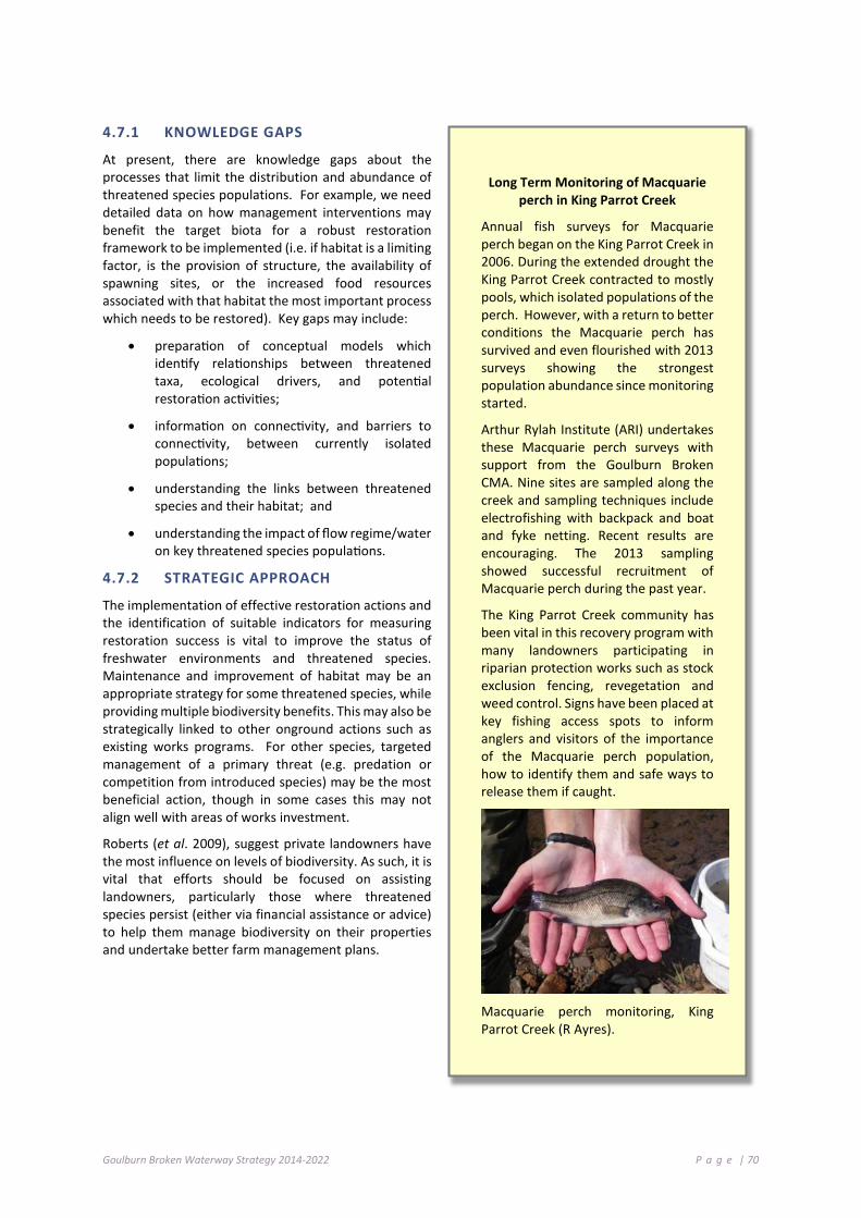
Goulburn Broken Waterway Strategy 2014-2022 P a g e | 70
4.7.1 KNOWLEDGE GAPS
At present, there are knowledge gaps about the processes that limit the distribution and abundance of threatened species populations. For example, we need detailed data on how management interventions may benefit the target biota for a robust restoration framework to be implemented (i.e. if habitat is a limiting factor, is the provision of structure, the availability of spawning sites, or the increased food resources associated with that habitat the most important process which needs to be restored). Key gaps may include:
• preparation of conceptual models which identify relationships between threatened taxa, ecological drivers, and potential restoration activities;
• information on connectivity, and barriers to connectivity, between currently isolated populations;
• understanding the links between threatened species and their habitat; and
• understanding the impact of flow regime/water on key threatened species populations.
4.7.2 STRATEGIC APPROACH
The implementation of effective restoration actions and the identification of suitable indicators for measuring restoration success is vital to improve the status of freshwater environments and threatened species. Maintenance and improvement of habitat may be an appropriate strategy for some threatened species, while providing multiple biodiversity benefits. This may also be strategically linked to other onground actions such as existing works programs. For other species, targeted management of a primary threat (e.g. predation or competition from introduced species) may be the most beneficial action, though in some cases this may not align well with areas of works investment.
Roberts (et al. 2009), suggest private landowners have the most influence on levels of biodiversity. As such, it is vital that efforts should be focused on assisting landowners, particularly those where threatened species persist (either via financial assistance or advice) to help them manage biodiversity on their properties and undertake better farm management plans.
Long Term Monitoring of Macquarie perch in King Parrot Creek
Annual fish surveys for Macquarie perch began on the King Parrot Creek in 2006. During the extended drought the King Parrot Creek contracted to mostly pools, which isolated populations of the perch. However, with a return to better conditions the Macquarie perch has survived and even flourished with 2013 surveys showing the strongest population abundance since monitoring started.
Arthur Rylah Institute (ARI) undertakes these Macquarie perch surveys with support from the Goulburn Broken CMA. Nine sites are sampled along the creek and sampling techniques include electrofishing with backpack and boat and fyke netting. Recent results are encouraging. The 2013 sampling showed successful recruitment of Macquarie perch during the past year.
The King Parrot Creek community has been vital in this recovery program with many landowners participating in riparian protection works such as stock exclusion fencing, revegetation and weed control. Signs have been placed at key fishing access spots to inform anglers and visitors of the importance of the Macquarie perch population, how to identify them and safe ways to release them if caught.
Macquarie perch monitoring, King Parrot Creek (R Ayres).

Goulburn Broken Waterway Strategy 2014-2022 P a g e | 71
Table 4-3: Flora and Fauna Guarantee Act 1998 listings and Action Statements for species, Potentially Threatening Processes and Communities - Riverine and Wetland related or Dependent
Flora and Fauna Guarantee Action Statements (Aquatic Dependent)
Barred galaxias (Galaxias olidus var. fuscus) No. 65; Macquarie perch (Macquaria australasica) (in prep.); Spotted tree frog (Litoria spenceri) No.112; Trout cod (Maccullochella macquariensis) (No. 38).
Fauna - Growling Grass-frog, Alpine Tree-frog; Murray Spiny-cray; White-bellied Sea-Eagle, Superb Parrot (RRG forest).
Flora - Fat Spectacles (Menkea crassa), Ridged Water-milfoil (Myriophyllum porcatum), Small Scurf-pea (Cullen parvum), Summer Leek-orchid (Prasophyllum canaliculatum), Narrow Goodenia (Goodenia macbarronii), Warby Range Swamp Gum (Eucalyptus cadens) and Buxton Gum (Eucalyptus crenulata).
Communities: Alpine Bog Community, Creekline Grassy Woodland (Goldfields), Granite Foothills Spring Wetland (North East); Lowland Riverine Fish Community of the Southern Murray-Darling Basin, Montane Swamp Complex, Red Gum No. 1 community.
Flora and Fauna Guarantee Threatening processes (Riverine and Wetland related)
Alteration to the natural flow regimes of rivers and streams.
Alteration to the natural temperature regimes of rivers and streams (i.e. cold water releases from impoundments).
Removal or degradation of native riparian vegetation along Victorian rivers and streams.
Habitat fragmentation and removal of wood debris from Victorian streams.
Increase in sediment input into Victorian rivers and streams due to human induced activities (i.e. land clearing).
Input of toxic substances into Victorian rivers and streams (i.e. agricultural chemicals).
Introduction of exotic fish species and native species translocated into waterbodies outside their natural range within a Victorian river catchment after 1770.
Loss of hollow-bearing trees in Victorian native forests.
Barriers to fish movement (i.e. weirs).
Introduction of diseases and parasites carried by exotic fish species which can effect native fish.
The invasion of native vegetation by environmental weeds.
Use of lead shot in cartridges for the hunting of waterfowl.
Use of Phytophthora-infected gravel in construction of roads, bridges and reservoirs.
Loss and degradation of native plant and animal habitat by invasion of escaped garden plants, including aquatic plants.
Table 4-4: Goulburn Broken fauna with EPBC Recovery Plans (Aquatic Dependent Species)
Recovery Plan Title Species Scientific Name Species Common Name
Spotted tree frog Recovery Plan Litoria spenceri Spotted tree frog
National Recovery Plan for the Trout cod 2008 Maccullochella macquariensis Trout cod
National Recovery Plan for Murray cod Maccullochella peelii peelii Murray cod
National recovery plan for Macquarie perch - In-progress Macquaria australasica Macquarie perch
National Recovery Plan for the Barred galaxias 2010 Galaxias fuscus Barred galaxias

Goulburn Broken Waterway Strategy 2014-2022 P a g e | 72
4.7.3 STRATEGIC PRIORITIES
The threatened aquatic species work program aims to ensure the survival of all threatened aquatic species and maintain current populations in the catchments to maintain current ecosystem function. Further, we aim to expand the range of species and communities and foster resilience within the waterway to ensure the maintenance and improvement of threatened species populations.
There is a need to prioritise sites containing threatened species based upon their resilience to avoid extinction. A multifaceted approach to prioritisation is required that takes into account biodiversity loss, resource limitations and cultural values while meeting overarching legislative obligations. An alternate consideration to prioritising individual species by geographical areas and rank these areas for conservation based on the number of threatened species they contain in addition to the risk posed by these threatening processes (Coates and Atkins 2001). Another approach for prioritising threatened species (and populations) is to examine and rank each threat in order to implement actions to mitigate their impacts. Managing waterways for threatened species must consider other cultural, social and economic values within the waterway and in adjacent reaches.
4.7.4 PRIORITY ACTIONS FOR THREATENED AQUATIC SPECIES
The following table details priority actions; the timeframe for implementation and the responsible agency, authority or group:
Action Timeframe Responsibility
Develop and implement strategies to improve the resilience of waterways to enable the re-establishment of robust self-sustaining populations of Macquarie perch and Trout cod in the Goulburn River between Lake Eildon and Barmah. In particular, ensure connectivity with satellite populations in Hughes Creek, Seven Creeks, King Parrot Creek, Holland Creek and Yea River.
2050 DEPI (ARI), GB CMA, community
Identify, prioritise and implement strategies to reduce extinction risk by translocation and stocking of threatened species.
2050 DEPI (ARI), Fisheries Victoria, GB CMA, community
Undertake research and monitoring to identify and prioritise recovery actions, in line with action statements and recovery plans and adaptive management principles.
2050 DEPI (ARI), Fisheries Victoria
Ensure connectivity with wetland and off channel habitats along the Goulburn river (Catfish and Macquarie perch).
2030 GB CMA
Deliver community initiatives and partnerships to maintain or improve habitat for threatened species and farm production, such as weed control, revegetation and soil and catchment stabilisation.
2014-2022 Agency stakeholders, community
Develop a plan for listed Aquatic biodiversity values including an objective for threatened species, threatening processes and communities and management approaches to optimise conservation outcomes and ecosystem function with resilience being achieved to the desired level.
2022 DEPI (Regional Services), DEPI (ARI), GB CMA

Goulburn Broken Waterway Strategy 2014-2022 P a g e | 73
4 .8 M A NAG E MEN T O F R EC RE AT I ON AL F I S HE RI E S
Recreational fishing makes an important social and economic contribution to regional Victorian communities. In particular, the Goulburn and Broken catchments provide some of the most popular native and trout recreational fishing opportunities in Victoria.
The Department of Environment and Primary Industries (Fisheries Victoria) is focused on managing fisheries in a balanced way to ensure ecological sustainability and social and economic outcomes. Fisheries Victoria is also responsible for implementing the State Government’s $16 million Recreational Fishing Initiative to improve recreational fishing opportunities by supporting fish habitat recovery works, improving angler access and facilities, fish stocking, protecting fisheries resources and education and compliance activities.
Recreational fishing is highly dependent on the health of the environment including the availability of suitable habitat, water quality and water flow regimes to sustain productive fisheries. Recreational anglers acknowledged this critical dependency in surveys (2009 and 2012) that revealed “repairing where fish live” was the most important recreational fishing investment priority. There is mutual benefit in Fisheries Victoria and recreational anglers working with the GB CMA to identify and collaborate on habitat related projects that lead to better fishing outcomes.
Each year, the Victorian Government, through the Recreational Fishing Licence Trust Account, disburses revenue from the sale of Recreational Fishing Licences to projects that will improve recreational fishing in Victoria. Since its inception in 2001, the Recreational Fishing Grants Program has funded 521 projects worth more than $21 million throughout Victoria.
4.8.1 KEY RECREATIONAL FISHERIES IN THE GOULBURN BROKEN CATCHMENT
The Goulburn Broken catchment includes some of the most popular recreational fisheries in Victoria. A 2012 survey of recreational anglers highlighted that this region features both the most popular recreational fishing lake (Lake Eildon) and river (Goulburn River). Other important fisheries in the GB CMA region include Lake Nagambie, Eildon Pondage, Waranga Basin and Broken River.
A more complete assessment of Victoria’s recreational fishing waters can be found in a Guide to Inland Angling Waters of Victoria at: www.dpi.vic.gov.au/fisheries/recreational-fishing/inland-angling-guide.
Broken Creek resnagging good for recreational fishing
More than 290 large snags (or around 600 cubic metres of woody debris) have been placed along almost 2.5 km of the Broken Creek downstream of Walshes Bridge.
The project, funded through the Victorian Government’s Recreational Fishing Licences Grants Scheme, aims to improve recreational fishing in the creek by providing habitat for native fish such as Murray cod and Golden perch (or Yellowbelly).
Scientists from the Arthur Rylah Institute mapped instream habitat in the Broken Creek between Numurkah and Nathalia to identify areas that had a low density of snags. This mapping provided a clear picture of the instream habitat in the Broken Creek in this section and allowed the project to select areas where resnagging would have the greatest benefit for native fish populations and anglers.
Monitoring will be carried out to measure the impact of the resnagging program on native fish populations within the Broken Creek.
Snags are the inland equivalent of coastal reefs and provide habitat for native fish and other animals such as tortoises and native water rats. Native fish use them to shelter from fast currents and sunlight and take refuge from predation. Native fish also use snags as feeding and spawning sites, and they are used as nursery areas for juvenile fish.
Resnagging the Broken Creek (GB CMA)

Goulburn Broken Waterway Strategy 2014-2022 P a g e | 74
4.8.2 STRATEGIC PRIORITIES
Fisheries Victoria, key partners and the GB CMA have identified the following key strategic priorities for the management of inland fishing:
• Maintain key fisheries assets;
• Advocate for fish habitat recovery works;
• Manage fish stocking;
• Encourage compliance with regulations;
• Improve angler access; and
• Develop recreational fishing opportunities.
4.8.3 FISHERY MANAGEMENT PRIORITIES
Fisheries Victoria and the GB CMA convened a workshop in July 2013 with key recreational fishing representatives and relevant agencies to identify key fisheries management priorities for the region. The ideas and proposals from this forum were reviewed by Fisheries Victoria against the strategic priorities and are captured as fishery management priorities. These priorities were then aligned with the key drivers of this Strategy. The outcomes of this workshop builds on past fishery management planning processes, in particular, the 2011 Goulburn Broken Fishery Management Plan.
4.8.4 PRIORITY ACTIONS FOR FISHERY MANAGEMENT
The following table details priority actions; the timeframe for implementation and the responsible agency, authority or group:
Action Timeframe Responsibility
Support habitat restoration works where they align with popular recreational fishing river reaches or critical habitat needs for threatened species (Fisheries Victoria Inland Fishing Survey 2012).
2021 DEPI, GB CMA
Investigate the feasibility of using over-bank environmental flows in the Goulburn and Broken Rivers to improve native fish recruitment.
2022 DEPI, GB CMA, MBDA
Investigate the feasibility of improving the native fish recreational fishing in the Waranga Basin through habitat improvement (Refer Goulburn-Murray Water Waranga Basin Land and On-Water Management Plan 2011).
2018 GB CMA, DEPI, VRFish, ATF
Support the re-establishment of woody habitat in the GB CMA region based on the outcomes of DEPI’s habitat mapping study recommendations (DEPI 2013g).
2025 DEPI, GB CMA
Focus efforts to establish stocked populations of Trout cod and Macquarie perch in the Goulburn River (between the junction of Hughes Creek and King Parrot Creek).
2022 DEPI, GB CMA, VRFish
Investigate the case for re-establishing freshwater catfish populations near the junction of the Broken Creek and Goulburn River confluence using the Vic Fish Stock consultative process.
2022 DEPI, Vic Fish Stock
Improve recreational fishing outcomes in the Goulburn River tailrace fishery by protecting and where needed, re-establishing riparian and instream habitat.
2022 GB CMA, DEPI

Goulburn Broken Waterway Strategy 2014-2022 P a g e | 75
4 .9 M A NAG E MEN T O F I NV A S I VE S PE CI E S
Invasive flora and fauna pose a major threat to the health of the region’s waterways. Management of invasive species requires a multi-faceted approach through planning and implementation over a range of jurisdictions.
An invasive species is a species that occurs, as a result of human activities, beyond its accepted normal distribution and threatens environmental, agricultural, cultural or other social values (DSE 2012).
Invasive species include organisms from other continents and translocated native species. Invasive species that may impact waterways include vertebrates, plants (aquatic and riparian species), invertebrates, algae, pathogens and diseases.
Priority invasive species within the Goulburn Broken catchment include:
Invasive Species Priority
Vertebrates European carp (Cyprinus carpio); Oriental Weatherloach (Misgurnus anguillicaudatus); Redfin (Perca fluviatilis); Brown trout (Salmo trutta); Rainbow trout (Oncorhynchus mykiss); Mosquito fish (Gambusia affinis).
Plants Blackberry (Rubus fruticosus agg. Species) and Willow (Salix spp.).
Cabomba (Cabomba caroliniana) and Arrowhead (Sagittaria).
The management of invasive species in waterways (DSE 2012) needs to be holistic and integrated with other waterway health activities, other pest plant and animal control works and fisheries management activities (i.e. Integrated Catchment Management Framework).
It is clear that initiatives articulated in this Strategy will be ineffectual without adequate resources being directed towards the management of invasive species.
Stocking of both native and introduced fish species takes place in Victoria to improve recreational fishing opportunities. At the state level, the Translocation Evaluation Panel advises Fisheries Victoria on issues related to the translocation of live inland aquatic organisms in accordance with protocols and guidelines. Regionally, stocking is considered through a consultative process involving regional input from land and waterway managers and recreational anglers (See Recreational Fishing Chapter 4.8).
There is currently limited understanding of how waterway restoration activities influence the establishment and spread of invasive species, including how activities designed to eradicate or reduce the impact of one invasive species can influence the establishment and spread of other invasive species. There is some evidence that control of invasive species can have unintended secondary consequences. It is recommended that a risk-based assessment is undertaken, including the development of a conceptual model to aid the identification of intended and unintended consequences.
Management Framework
The Victorian Waterway Management Strategy (DEPI 2013b) sets out policy direction on issues pertinent to waterway health, including the threat from invasive species. Waterway managers have an important role in undertaking regional actions to contain high risk established invasive species and in protecting high value rivers, estuaries and wetlands from the range of impacts associated with invasive species. A framework for the management of invasive species in waterways is outlined in Table 4-5.

Goulburn Broken Waterway Strategy 2014-2022 P a g e | 76
4.9.1 PRIORITY ACTIONS FOR INVASIVE SPECIES
The following table details priority actions; the timeframe for implementation and the responsible agency, authority or group:
Action Timeframe Responsibility
Assess the risks of inland aquatic invasive species spread through the Victorian water grid.
2015-2018 DEPI, Waterway managers, Water corporations
Support multi-jurisdictional process and actions to manage invasive species.
Ongoing DEPI, Waterway managers, Water corporations
Support research into the management and control of invasive species.
2015-2050 DEPI, Waterway managers, Water corporations
Identify stream lengths that may require selective removal in very limited sections of a few upper catchment streams to protect valuable species and ecosystems, working in collaboration with relevant stakeholders and interest groups.
2014-2022 DEPI (Regional Services / ARI), Waterway managers
Encourage and support efforts for control methods and management of carp within priority waterways (identified) within the region. Highlight level of urgency.
2018 DEPI (ARI), GB CMA
Facilitate “carp muster” days on identified “hot spots” (waterways, storages).
2014-2022 DEPI (ARI), Fisheries Victoria, GB CMA
Encourage support efforts for improved control of invasive plant species including biological and chemical control methods.
2022 Research organisations

Goulburn Broken Waterway Strategy 2014-2022 P a g e | 77
Table 4-5: Framework for the management of invasive species in Victorian waterways
Goal Strategic approach
Lead Victorian policy Australian/State Government actions
Regional actions
Prevention and preparedness
Prevent new high risk invasive species from establishing in Victoria or spreading to uninvaded Victorian catchments
Species (threat) based
Biosecurity Strategy for Victoria (2009) Invasive Plants and Animals Policy Framework (2010)
• Undertake pre-border and border security
• Undertake risk assessments • Develop and implement
reporting framework
• Support national and statewide programs aimed at preventing the introduction and establishment of new high risk invasive species in waterways
• Support informed community effort in invasive species management in waterways
• Surveillance monitoring in waterways Eradication Eradicate high risk invasive
species in the early stage of establishment
Species (threat) based
Biosecurity Strategy for Victoria (2009) Invasive Plants and Animals Policy Framework (2010)
• Clearly identify agency roles and responsibilities for participating in emergency eradication responses
• Develop and implement emergency preparedness and rapid response plans
• Co-ordinate eradication activities at national/state scales
• Eradicate all newly establishing populations of Regionally Prohibited Weeds and other identified high risk invasive species in waterways
• Support national and statewide programs aimed at eradicating high risk invasive species in waterways
• Support informed community effort in invasive species management in waterways
• Surveillance monitoring in waterways
Containment Contain high risk invasive species
Species (threat) based
Victorian Waterway Management Strategy (DEPI 2013b)
Lead agency engages with waterway managers, water corporations and communities on containment programs
• Prevent identified high risk established invasive species in waterways from spreading outside core infestation boundaries
• Eradicate outlier infestations • Protect assets within core infestation • Support informed community effort in invasive
species management in waterways • Surveillance monitoring in waterways
Asset based protection
Reduce the impact of established invasive species
Asset (value) based and Species (threat) based
Victorian Waterway Management Strategy (DEPI 2013b)
Lead agency engages with waterway managers, water corporations and communities on community education, asset management planning, implementation, monitoring and reporting
• Assess the threat of invasive species on the values of waterways
• Undertake appropriate actions to reduce the impacts of invasive species on the values of priority waterways
• Support informed community effort in invasive species management in waterways
• Surveillance monitoring in waterways

Goulburn Broken Waterway Strategy 2014-2022 P a g e | 78
4 .10 M A NAG E MEN T O F T HE R I VE R CH ANN EL
Management of the waterway channel (DEPI 2013b) needs to be based on an understanding of the geomorphological and hydrological processes that exist within our catchment.
The focus of early waterway management was directed towards improving channel efficiency, navigation and preventing nuisance flooding by opening the channel (removal of instream obstructions), channel straightening and channel realignment. Fortunately most of these actions are not currently practiced.
Erosion and sedimentation processes are comparatively balanced where catchments and water regimes are largely unaltered. In such situations, the focus of management is on maintaining natural processes, managing invasive species and managing waterway related bushfire risks, flood risks and drought impacts.
River channels may become unstable and channel forms altered where natural river channel processes have been accelerated or changed by land use in the catchment, outdated river management activities or by changes to the water regimes. These changes may result in lower resistance to flood damage, increased erosion and alterations to overbank flow.
Improving channel stability and the condition of river channels in degraded areas requires a long-term approach that focuses on riparian management programs (see Chapter 4.1) and Integrated Catchment Management (see Chapter 4.12.2).
Successful management of the river channel requires an approach that:
• clearly identifies the uses (values) of the waterway;
• clearly identifies roles and responsibilities;
• promotes partnerships with land and water managers, local government and the community;
• sets out the management approach; and
• defines best practice standards for maintenance and improvement works.
Waterways within the Goulburn Broken catchment will be managed to achieve appropriate rates of erosion, sedimentation and avulsion over the long-term, consistent with natural processes.
Management of waterways will focus on maintaining or improving the bed, banks, instream habitat, riparian land and overall integrated catchment management to improve resistance and resilience to adverse impacts of waterway processes on river channel condition and public infrastructure.
Options for changing river operations to improve the water regime in priority regulated rivers will be investigated as part of the regional Waterway Strategies (See Chapter 4.3) (DEPI 2013b)

Goulburn Broken Waterway Strategy 2014-2022 P a g e | 79
4.10.1 WORKS ON WATERWAYS
Works and activities within waterways include the construction of bridges and access crossings, bed and bank erosion control works, stormwater drainage outlets, removal of invasive instream vegetation, installation of pipelines and stream realignment.
Such works have the potential to degrade the physical form of waterways and reduce the environmental values of the channel and associated habitats (e.g. crossings, access points, bridges). It is important that controls, standards and guidelines are in place to manage the risks posed by such works and activities.
Works on Waterways
The rationale for the Goulburn Broken CMA to manage works on waterways (Regulatory Impact Statement, RMCG 2013) is to ensure that:
Works (e.g. construction of crossings and deviation of flows) and activities on waterways (e.g. erosion control) are regulated under one consistent framework to minimise the impact on the waterway; and
The full costs associated with undertaking non-beneficial works on waterways are borne by the people who undertake those works, not by the broader community.
Where works and activities in waterways are not undertaken in accordance with best-practice standards, they may pose a risk to waterway values, landowners or public infrastructure. In addition to the regulatory provisions under the Water Act 1989, the Technical Guidelines for Waterway Management and the Guidelines for Assessment of Applications for Permits and Licences for Works on Waterways provide guidance to waterway managers on best management practice for engineering works in waterways.
4.10.2 PRIORITY ACTIONS FOR WORKS ON WATERWAYS
The following table details priority actions; the timeframe for implementation and the responsible agency, authority or group:
Action Timeframe Responsibility
Provide adequate resources to enable the management of works on waterways to prevent threats to the ecological systems and constructed assets.
2014-2022 GB CMA, DEPI

Goulburn Broken Waterway Strategy 2014-2022 P a g e | 80
4.10.3 PREVENTING DEGRADATION OF THE RIVER CHANNEL
Works and activities need to consider erosion and sedimentation processes and be regularly maintained to minimise the risk of flood damage.
Waterway managers (DEPI 2013b) will work with proponents of works and activities in waterways to:
1. ensure compliance with regulatory requirements
2. promote best-practice standards of design to:
maintain or improve the environmental resilience of the site and surrounds;
avoid causing instability or adverse site impacts or increased flood impacts;
minimise the risk of damage to the works from future flooding and waterway processes;
reduce the likelihood of affecting other parties and infrastructure; and
encourage adequate operation and maintenance of works into the future.
Large woody debris including logs or “snags” and native instream vegetation are important habitat in rivers. They provide shelter, food resources and breeding sites for a range of instream animals, including threatened fish species, as well as contributing to biological processes within the river channel.
Large woody habitat is an important structural component of rivers, assisting in the formation of features such as scour pools and channel bars and in stabilising the river channel. In the major lowland rivers, large woody habitat may be the only stable substrate and provide an important source of instream nutrients.
Instream diversity has been heavily modified since European settlement. Extensive removal of large woody habitat and instream vegetation clearing occurred in Victoria from the late 1800s to late 1990s to increase conveyance of flood water (DEPI 2013a,b). However, extensive research has shown that large woody habitat has negligible impact on channel capacity and removal does little to improve flood conveyance. In addition, instream vegetation and large woody habitat structures have been found to reduce bed erosion.
The removal of large woody habitat and instream vegetation is a recognised threatening process. Removal of this resource leads to increases in flow velocity, bed degradation, channel enlargement and loss of important instream habitat.
There may be some isolated instances where the removal of large woody habitat or instream vegetation is warranted to maintain the social or economic values of a waterway or to reduce an immediate threat to public infrastructure or public risk. In such cases, waterway managers will need to balance the habitat benefits against the level of risk.
The Victorian Investment Framework funded project, “Instream Woody Habitat Assessment” (IWH), aimed to assist government and regional waterway managers in prioritising the protection and rehabilitation of instream woody habitat in rivers (DEPI 2013e). Researchers from the Department of Environment and Primary Industries’ (DEPI) Arthur Rylah Institute (ARI) have been working with Fisheries Victoria, Catchment Management Authorities, the University of Melbourne and Melbourne Water to investigate past and present IWH densities in Victorian rivers.
The project mapped IWH densities in approximately 38,000 river reaches across Victoria. Field assessments of natural IWH densities were undertaken in “pristine” river reaches using hand-held GPS and underwater sonar. The results for the Goulburn Broken region shows that many of our waterways are depleted in woody habitat. These results will guide the strategic implementation of habitat improvement activities in the region.
On the basis of the IWH project and the AVIRA risk assessment process, priority waterways for the improvement of instream diversity include: Goulburn River (reaches 1–8), Goulburn River (reaches 9–14), Broken Creek (reaches 21–23), Broken River (reaches 1–4) and lower floodplain of Goulburn River tributaries (Yea River, King Parrot Creek and Acheron River).

Goulburn Broken Waterway Strategy 2014-2022 P a g e | 81
Large woody habitat or native instream vegetation will not be removed from river channels unless it is demonstrated to pose a serious risk to public safety or public infrastructure. Realignment or anchoring of large woody habitat will be undertaken where feasible, rather than removal (DEPI 2013b).
Where programs to reinstate large woody habitat or instream vegetation are planned to improve the condition of the river channel, the benefits and risks will be assessed in consultation with the community.
Active use of the river channel through power boating and associated activities may be a threat to the condition of the river channel:
• open water is often preferred hence the removal of instream debris critical for instream fauna may be required; and
• wave action can pose a threat to bank stability and riparian vegetation.
While the GB CMA is the “caretaker of river health” and is responsible for particular aspects of the region’s waterways management, there are a range of other agencies with common interests but differing regulatory roles. For example, the Marine Safety Act 2010 is administered by some local governments and there needs to be a balance between recreational use of waterways and minimising risk to the environment.
4.10.3 PRIORITY ACTIONS FOR RIVER CHANNELS
The following table details priority actions; the timeframe for implementation and the responsible agency, authority or group:
Action Timeframe Responsibility
Further refine priority reaches and mapping for maintenance and improvement to instream habitat across the region.
2014-2018 GB CMA, DEPI (ARI), Fisheries Victoria
Install IWH within priority river reaches (see Chapter 7). 2014-2022 GB CMA, DEPI (ARI), Fisheries Victoria
Develop recreational boating strategies and plans in key areas as identified by the Boating Authority.
2014-2018 GB CMA, Local Government
Establish appropriate zoning of particular uses and controls within key boating zones.
2014-2022 GB CMA, Local Government, DEPI (ARI)
4 .11 M A NAG E MEN T O F EXT RE M E E VE NT S
The Goulburn Broken catchment has experienced several extreme events over the past 10 years. Extensive bushfires occurred in summers of 2006-2007 and in 2009; unseasonal summer flooding occurred in many sub-catchments in 2010, 2011 and 2012 and we experienced drought conditions over a seven year period.
The purpose of this section is to clarify the management framework to reduce, respond to and recover from the impacts of extreme and catastrophic events and waterway incidents. Table 4-6 highlights the impacts of extreme events and waterway incidents.

Goulburn Broken Waterway Strategy 2014-2022 P a g e | 82
Table 4-6: Impacts of extreme events and waterway incidents
Event Impacts Floods • accelerated rates of river channel erosion;
• channel avulsions (the abandonment of the main river channel in favour of a new course);
• channel widening; • sedimentation, infilling of deep pools and shallow channels, and impacts on
wetlands; • loss of large woody habitat structures; • damage to waterway and environmental activities (fences, riparian vegetation
and erosion control activities); • spread of invasive species; • damage and threats to infrastructure (erosion and debris); • waste from sewage treatment facilities may enter waterways; • loss of livestock; and • reduced raw water quality.
Bushfire • increase in runoff may result in flooding; • increased sediment and nutrient loads into waterways; • nutrient increase may result in algal blooms; • increased erosion may result in sediment transport; • reduced oxygen levels can cause fish deaths; • natural breeding cycles of aquatic native species may be disrupted and
biological functions impaired; • native animal habitat destroyed; • increased risk of weed invasion; • loss of riparian vegetation through bushfire can reduce shading, thereby
increasing the water temperature of rivers or wetlands; • increase the risk of erosion in the next flood; • contamination of water storages and potable water supplies with ash,
sediment and fire retardants; • damage public infrastructure and waterway assets (fences, revegetation and
erosion control works); and • livestock deaths.
Drought • reduce pool connectivity and native fish movement; • loss of immobile aquatic species; • reduced instream water quality; and • change of riparian vegetation structure.
Waterway Incidents: Low DO blackwater and algal blooms
• reduced instream water quality; • fish deaths; and • damage to aquatic flora and fauna.
Chemical Spills • fish deaths; • damage to aquatic flora and fauna; and • water unfit for many uses (human, stock, etc.).
4.11.1 EMERGENCY MANAGEMENT ARRANGEMENTS
Floods and bushfires, along with a range of other events, may be classified as emergencies (DSE 2012). Key legislation and policies for emergency management in Victoria include the Emergency Management Act (2013), underpinned by the Emergency Management Manual Victoria, that identifies high-level roles and responsibilities for agencies involved in emergency management. Further changes to the Emergency Management Act (2013) will be made in 2014 and 2015. The Manual also contains the State Emergency Response Plan, State Relief and Recovery Plan and outlines structures for emergency planning at state and regional levels.

Goulburn Broken Waterway Strategy 2014-2022 P a g e | 83
Emergency management
Emergency management consists of three types of activities.
1. Prevention, mitigation and preparedness activities eliminate or reduce hazard impacts, increase community or environmental resilience, establish planning arrangements, and increase community education and awareness.
2. Response activities take place during and immediately after an emergency event.
3. Recovery activities involve reconstruction of physical infrastructure and restoration of affected environments and communities.
4.11.2 PREVENTION, MITIGATION AND PREPAREDNESS
A Regional Water and Contingency Planning Group that assesses risks and responds to waterway incidents is established in the Goulburn Broken region. Group members and partners have developed and signed a ‘Partnership Agreement for Preparedness and Response to Waterway Incidents in the Goulburn Broken catchment’.
Members of the Group include, but are not limited to: Department of Environment and Primary Industries (formally Sustainability and Environment), the Environment Protection Authority Victoria, the Goulburn Broken Catchment Management Authority, Goulburn-Murray Water, Goulburn Valley Region Water Authority, North East Region Water Authority, Representatives from local government, Waterwatch, the Regional Water Monitoring Partnership and the Department of Human Services. This agreement is considered a critical frontline service by partners.
Waterway managers (DEPI 2013b) need to plan and prepare for the impacts of floods and bushfires on waterways and public infrastructure. Activities that may reduce such risks include: undertaking erosion control works to prevent erosion at sites of high energy flows and removal of debris from infrastructure built up during a previous flood to reduce the risks to these assets in future extreme events.
Planning for the impacts of bushfire is problematic. The scale and impacts of bushfires are unpredictable and limit the ability to protect waterways and public infrastructure. Water yield and quality are considered in the strategic bushfire management planning process and inform the development of bushfire management strategies.
4.11.3 RESPONSE ACTIVITIES
Urgent works may be required following extreme flood or bushfire events to address immediate risks to waterway health and infrastructure.
Required activities may include: clearing flood debris in waterways to maintain public infrastructure; stabilising waterways affected by erosion threatening public infrastructure; addressing threats to water quality or relocating threatened species that cannot survive in waterway habitats affected by bushfire.
In this period of activity it may also be necessary to support water quality and flood level data capture.
4.11.4 DISASTER RECOVERY AND REHABILITATION
It is necessary to undertake an evaluation of any necessary emergency stabilisation, rehabilitation and recovery works immediately following an event. This will be generally undertaken in partnership between all regional government agencies.
This assessment will clarify the nature and extent of the event(s), recommend strategies to reinstate the damage caused and provide an estimate of cost implications. Waterway management program priorities may need to be adjusted to enable priority waterway management actions to be undertaken.

Goulburn Broken Waterway Strategy 2014-2022 P a g e | 84
4.11.5 PRIORITY ACTIONS FOR MANAGEMENT OF EXTREME EVENTS
The following table details priority actions; the timeframe for implementation and the responsible agency, authority or group:
Action Timeframe Responsibility That the Regional Water and Contingency Planning Group continue to operate to plan and respond to waterway incidents.
Ongoing Regional Water Quality Partners
Provide Input to Fire Protection Plans, Fire Operation Plans and Municipal Emergency Management Plans to ensure that high value waterways are maintained.
Ongoing Catchment Management Authorities
(from Policy 15.4 VWMS) Adopt a risk-based approach to address the impacts of floods and bushfires on waterways and associated public infrastructure. Develop a program of onground works to reduce the impacts on waterways and public infrastructure from flood and bushfire. The program will be included in the regional Waterway Strategies and will constitute the disaster mitigation strategy for flood and bushfires in relation to waterways in the catchment management region.
2018 Waterway managers (Catchment Management Authorities) and regional partners
Establish a regional Planning Group to respond to emergency works and monitoring following extreme events.
2018 Waterway managers (Catchment Management Authorities) Frontline service
For natural flood and bushfire disasters, waterway managers will prepare and submit to the Department of Treasury and Finance, applications for funding in accordance with the National Natural Disaster Relief and Recovery Arrangements Determination 2011.
2014-2022 Waterway managers (Catchment Management Authorities) Frontline service
Following extreme events a review of waterway priorities will be undertaken.
as required (2022)
Waterway managers (Catchment Management Authorities) Statement of Obligations/Water Act (1989)
4 .12 I N F L UEN CE O F T H E SU R RO UN DI N G CAT CHM E NT
The condition of neighbouring catchments and land is a key driver of waterway condition (DSE 2013). Therefore management of waterway condition must consider and integrate with the management of the surrounding catchment. It is also important to integrate with related catchment management and regional programs.
Some activities occurring on the land surrounding or adjacent to waterways have a significant effect on water quality, bed and bank stability, floodplain connectivity, aquatic biodiversity and riparian vegetation (see Table 4-7).
Catchment management must consider a range of scales, from landscape, to sub-catchment through to property.
These linkages are currently recognised by the integrated catchment management framework operating within the Goulburn Broken region. While funding may often be silo-based every effort is made to integrate projects at a local scale, and to achieve multiple benefits from investment. With the proposition of RCS based funding, silos will be removed and lead to more effective integrated projects and simplified community participation.
Major management activities that influence river health are shown in Table 4-7 (DSE 2002).

Goulburn Broken Waterway Strategy 2014-2022 P a g e | 85
Table 4-7: Major land management activities that influence river health
Activity Impact on Waterway Condition Catchment clearing including urbanisation, peri-urban development and rural subdivisions
• Changed stream flows - peakier, less base flow; can increase instream erosion and sedimentation;
• Construction of dams and weirs have altered the natural hydrograph; • Increased catchment erosion hence sedimentation of streambed,
smothering biota; • Poor quality runoff causing deterioration of instream habitat; • Industrial and urban pollutants and waste have contributed to loss of water
quality; • Increased salinity levels; • Loss of wetland habitat; • Widening of channels; • Shallowing of channels; • Filling in of deep pools with sand and sediment; • Invasion of exotic biota. Riparian land and wetlands have been invaded by
aggressive exotic domestic and agricultural weeds; and • The removal of deep rooted vegetation has led to a rise in the water table,
mobilising salt stored in the soil, contributing to a reduction in water quality. Inappropriate land management
• Increased input of contaminants such as sediment, salt or nutrients, depending on land use;
• Rabbit infestation, which can damage riparian vegetation, increase erosion and hence increase sediment input;
• Loss of wetland habitat; and • Increased runoff, (containing high concentrations of nutrients including
Phosphorous (P) and Nitrogen (N)), has caused extensive rill, sheet and gully erosion.
Disposal of poor quality effluents
• Reduced habitat quality from poor water quality; • Changed species composition; and • Algal blooms.
Degradation of the frontage/riparian land
• Changed vegetation structure and species composition, especially of the understorey;
• Reduced regeneration; • Weed invasion; • Bank instability hence erosion and sediment deposition in waterways; • Reduced/no input of organic matter and snags to rivers; • Reduced quality of bank habitat for aquatic animals; • Bank erosion and sedimentation leading to changed channel shape; • Increased turbidity; • Increased water temperature; • Changes in dissolved oxygen levels in the water; • Loss of woody debris; • Channel incision; • Compaction of the soil by hoofed feet has led to a decline in the soil
structure and has contributed to the increase in runoff, further erosion, nutrification and continued river degradation; and
• Decreased interception of rainwater by riparian vegetation due to its removal.

Goulburn Broken Waterway Strategy 2014-2022 P a g e | 86
4.12.1 STRATEGIC PRIORITIES
Key strategic priorities for the management of adjacent lands for the protection of waterways over the life of this Strategy are:
1. Integrated Catchment Management (See Chapter 4.12.2)
2. Riparian Management (See Chapter 4.1)
3. Floodplain Management (See Chapter 4.5)
4. Protection of Water Quality (See Chapter 4.2)
5. Planning (Property, Local and Catchment Scale, See Chapter 4.12.3)
6. Water Savings (See Chapter 4.12.4)
7. Integrated Water Cycle Management (See Chapter 4.12.5)
4.12.2 INTEGRATED CATCHMENT MANAGEMENT
Integrated catchment management is the co-ordinated involvement of agencies, stakeholders and the catchment community in policy making, planning, and management to protect the resilience of the catchment. Integrated catchment management recognises the intrinsic linkages between land use in catchments and subsequent impacts on land, water and biodiversity and seeks a holistic approach to their management.
The Waterway Program will be integrated with other key regional programs based on the seven Social Ecological Systems (SESs) or landscapes: Agricultural Floodplains; Productive Plains; Commuting Hills; Upland Slopes; Southern Forests; Urban and catchment wide. The planning framework for the catchment is shown in Figure 4-3.

Goulburn Broken Waterway Strategy 2014-2022 P a g e | 87
Figure 4-3: Integrated Catchment Planning (Catchment to SES) (source Goulburn Broken Regional Catchment Strategy)
4.12.3 PLANNING
Catchment and regional scale
While much can be undertaken to maintain or improve the condition of our waterways, management must consider the broader context of the entire catchment.
The Department of Planning and Community Development (DPCD) is responsible for land use planning and environmental assessment in Victoria. This includes managing the regulatory framework and providing advice on planning policy, strategic planning and urban design.
Under Victoria’s planning system, local councils and the Victorian Government develop planning schemes to control land use and development, and to ensure the protection and conservation of land.
Sub-regional scale
Sub-regional scale planning will be undertaken through the development of SES Integration Plans, which will be promoted by the CMA.
Local scale
Local scale planning will be implemented through the Whole Farm Planning (WFP) process of planning, property design and management based on natural resources and economic factors.
Whole farm planning focuses on all of the farm assets (physical and nonphysical) over a long period of time (perhaps several generations). WFP incorporates the knowledge and skills to be able to plan such aspects as a sub-division, irrigation layouts, assess land capability and potential of a farm.

Goulburn Broken Waterway Strategy 2014-2022 P a g e | 88
Key components of a Whole Farm Plan include: land classing, soils, farm water supply, biodiversity, pest plants and animals, pastures, succession planning, waterway assets, grazing management, drought management, prioritising works, identifying threats and assets, cropping techniques, tillage and development of realistic action plans.
4.12.4 WATER SAVINGS
The Farm Water Program began in 2009 as a result of a consortium of Northern Victorian agencies and industry organisations (led by the GB CMA) developing a funding proposal to help irrigators achieve farm water savings through improved farm irrigation systems.
Water savings are shared between farmers and the environment, with at least half the water savings transferred to the Victorian or (mainly) Commonwealth environmental water holder. This means more water is also available to protect and restore waterway health, which in turn builds the resilience of the catchment’s waterways and secures supply for domestic, industrial and agricultural use.
More efficient water delivery systems (on and off farm) reduce groundwater accessions and nutrient runoff and help address re-emerging salinity and water table issues in the catchment’s Agricultural Floodplains.
Types of farm works funded include improving border-check irrigation by lasering, reuse systems, outlet automation, appropriate flows, farm channel reconnections, installing pipes and risers, installing scheduling equipment, including soil, plant or weather monitoring systems to calculate water needs; and conversion of border check irrigation to a pressurised system including centre pivot, linear move, fixed sprinkler or surface and sub-surface drip.
There are several features of the Farm Water Program that ensure best practice (and reduce risk). These are:
• works are based on robust Whole Farm Plans (these have been undertaken across the region for more than 20 years);
• water savings are based on a water-savings calculator, developed from research over the past 20 years;
• costings are based on quoted costs and checked against regional industry standards;
• the Farm Water Program includes all the main partners in water management in Northern Victoria including Northern Victoria Irrigators, Dairy Australia, North Central CMA, North East CMA, Goulburn-Murray Water, DEPI and Goulburn Broken CMA (lead partner); and
• there are synergies with the irrigation modernisation program and land and water management plans.
The program has significant flow on effects for local economies across the Goulburn-Murray Water services area, creating jobs, boosting industry confidence and maintaining social vigour.
To date, more than $200 million has been secured from a range of sources: the Australian Government’s On Farm Irrigation Efficiency Program ($46 million); the former Northern Victorian Irrigation Renewal Project ($16 million); the Victorian On Farm State Priority Project ($45 million) and the Victorian Farm Modernisation Project (up to $100 million delivered in three tranches).
The program is being delivered in three rounds. Round 1 (148 projects worth $35 million, saved a total of 18 GL) was completed in March 2013 and Round 2 (234 projects, worth $61 million, will save a total of 33 GL) is due to be completed by March 2014. Expressions of interest for Round 3 (worth $30 million) closed in 2013/2014.
4.12.5 INTEGRATED WATER CYCLE MANAGEMENT (IWCM)
New pressures are placed on the management of our precious water resources as the region’s urban centres develop and Melbourne’s Growth Corridor extends northwards into the region. Increased growth places additional pressures on drinking water supplies, the quality and quantity of storm water runoff, drainage networks, and wastewater management facilities. All of these pressures will potentially impact on waterway health, the environment and the liveability of our communities and the impacts may be exacerbated by climate variability.
The Living Victoria systems analysis approach has been used to inform the development and publication of a new water cycle planning framework for metropolitan Melbourne, “Melbourne’s Water Future” based on Integrated

Goulburn Broken Waterway Strategy 2014-2022 P a g e | 89
Water Cycle Management principles. Similar spatial analysis and systems modelling in regional Victoria is expected to provide a template for Integrated Water Cycle Management in the regions.
The development of these regional frameworks will be co-ordinated by the Office of Living Victoria. The Office of Living Victoria (OLV) proposes to work with key regional stakeholders, water authorities, local government, catchment management authorities, regulators, the development industry, and all other identified stakeholders to improve the water efficiency and liveability of existing and new communities.
A whole of water cycle planning and management approach in new urban developments and the urban infill/redevelopment of existing towns can ensure there is sufficient fit for purposes water for the community and the environment.
Benefits of the program include:
• Water quality (Refer to Water Quality Chapter 4.2);
• Environmental Flows;
• A community engaged in whole of water cycle management;
• Suburbs old and new designed with water in mind;
• Sensible use of water in our homes, gardens, community facilities and businesses;
• Resilient water systems;
• Improved natural waterways; and
• Reduced inefficiency and waste.
Some elements identified in the development of Melbourne’s Water Future that may translate to rural areas include but are not limited to: the use of rainwater tanks on lots to mitigate storm water runoff, the use of rain water tanks to provide water supplies for non-potable uses such as toilet flushing, washing machines and gardens, better utilisation of stormwater through rain gardens, swale drains and nature strips, using existing and constructed wetlands to act as bio-filters, improving water quality before reuse or return to stream, commercial building reuse of water from roof surfaces and paved areas, sports clubs redirecting stormwater to their grounds, and consideration of purple pipes (recycled water) for substitution for non-potable and industrial uses.
4.12.6 ENGAGEMENT AND PARTICIPATION OF OUR COMMUNITY
Private landowners, including farmers, landowners and absentee landowners, are the largest group of stakeholders that can bring about improvements to our catchments and waterways.
Our community gains a more productive landscape and a healthier environment through the implementation of best practice property management. The implementation of best practice often follows financial support through incentives and grants. This follows the decision by the relevant authority that there is an appropriate level of landowner support and capacity to implement best practice.
It is important that the landowners not only recognise their responsibilities but also that adopting best management practices can lead to improvements to their bottom line.
Community engagement needs to be inclusive and involve (but not limited to): anglers, sporting clubs, community groups and clubs, field naturalists, sporting shooters, etc.

Goulburn Broken Waterway Strategy 2014-2022 P a g e | 90
4.12.7 SALINITY MANAGEMENT AND WATERWAY HEALTH
The management of salt within the landscape and the related threat to the region’s wetlands and waterways is recognised as one of the critical aspects of the overall natural health of the Goulburn Broken catchment.
The GB CMA, with support of its regional partners and the Victorian government, manages salt impacts in accordance with the Murray-Darling Basin Salinity Management Strategy. This involves regular monitoring and analysing of surface drainage systems, stream flows and groundwater pumping activities to estimate the salinity impacts of regional activities. The quantity and quality of stream flows is monitored at key locations across the catchment to allow the separation of salinity sources on the key rivers and streams.
The management of salt flows to the River Murray, as the key recipient of flows, is the cornerstone of the planning and operation of the various salinity programs across the Basin. The co-ordinated management approach is reliant on continued monitoring and reporting to allow trends, changes and key threats and opportunities to be identified and addressed.
The GB CMA will need to review its salinity accountability arrangements to ensure salinity impacts remain within acceptable levels under the new Murray-Darling Basin Plan Water Quality and Salinity Management Plan.
4.12.8 PRIORITY ACTIONS, INFLUENCE OF THE SURROUNDING CATCHMENT
The following table details priority actions; the timeframe for implementation and the responsible agency, authority or group:
Action Timeframe Responsibility Facilitate adoption and implementation of IWCM principles in the region. Develop and implement IWCM projects.
2015-2019 GB CMA, Water Corporations (Goulburn Valley Water) and Municipalities
Progress partnership approach to establish programs that leads to a reduction in water use across the catchment.
2014-2022 GB CMA, Water Corporations (Goulburn Valley Water) and Municipalities
Promote best practice: multi-benefit gaining a more productive landscape and a healthier environment within the Communications Strategy (see Chapter 8).
2015-2021 DEPI, GB CMA and Landcare
Include waterways as key features (in all levels of planning) within Local Planning including Whole Farm Plans.
2015-2021 DEPI, GB CMA, Landowners and Landcare
Provide protection for key waterways through Land Use Planning.
2015-2021 Local Government, DEPI, GB CMA
4 .13 P O T EN T I A L I MP ACT S A ND A DA PT I ON T O CL I MAT E C HANG E
It is generally accepted (Dyer et al. 2012) that the climate is changing and it is predicted that major changes to runoff, stream flow and water quality will result. These changes are likely to leave freshwater ecosystems exposed to increased risk of degradation.
Evidence now suggests that most of the warming observed in the last 50 years is due to human activities (DSE 2012; http://www.climatechange.vic.gov.au/what-is-climate-change).
Climate change has the potential to adversely impact our environment, our communities and our economy. It is widely considered that as a community we need to take action now to reduce our greenhouse gas emissions and prepare for the potential impacts of climate change.
Climate change may potentially alter global and local climates. In Victoria, this could mean a warmer and drier future, with an increasing likelihood of more extreme events such as heatwaves, bushfires and storm surges.
This Chapter details how potential climate change is to be considered into the future to maintain and improve the condition of waterway values.

Goulburn Broken Waterway Strategy 2014-2022 P a g e | 91
4.13.1 PREDICTIONS
The future climate of the Goulburn Broken region is expected to be hotter and drier than it is today (DSE 2008b). By 2030, average annual temperatures will be around 0.8°C warmer but the greatest increases are expected in spring and summer (0.9°C). The number of hot days (days over 30°C) is also expected to increase. Reductions in the total average annual rainfall of around 3% are expected, with the greatest reductions occurring in spring (7%). Increases in potential evaporation and reductions in relative humidity are expected to contribute to drier conditions. More frequent extreme events such as extreme rainfall, bushfires and droughts are expected (DSE 2008b).
The scenarios and assessment of impacts are shown in Table 4-8:
Table 4-8: Summary of projected annual climate changes for the Goulburn Broken region relative to 1990 (80% confidence range)
Season Attribute 2030 2070 (lower emissions)
Annual Average Temperature +0.9°C (0.6 to 1.2°C) +1.5°C (1.0 to 2.0°C)
Average rainfall (%) -3% (-9% to +1%) -6% (-14% to +2%)
Potential Evaporation (%) +3% (1 to 5%) +4% (1 to 8%)
Wind Speed (%) -1% (-6 to +4%) -1% (-10 to +6%)
Relative Humidity (%) -0.7% (-1.5 to -0.1%) -1.2% (-2.4 to -0.1%)
Solar Radiation (%) +0.8% (no change to +1.9%) +1.3% (no change to +3.1%)
For further information see: Climate Change in Goulburn Broken document.
4.13.3 POTENTIAL IMPACTS OF CLIMATE CHANGE
Victoria’s communities, industries and environment are likely to be impacted by climate change. The difficulty is, and will remain for some time, uncertainty over the scale and timing of climate change impacts. However, a high level of variability is certain (DSE 2012a).
With the additional effects of climate change, human influences will become even more severe as ecosystems are progressively exposed to greater risk.
Preliminary research (DSE 2012a) suggests climate change is already impacting on Victoria’s plants and animals. Many of Victoria's ecosystems have a limited ability to adapt to climate change (DSE, 2012a). Those restricted to small geographic areas, or unable to migrate fast enough to keep pace with shifting climatic zones, will be particularly vulnerable. However, some ecosystems and species will be advantaged or unaffected by climate change.
Projected drying trends over much of Victoria will render water resources increasingly vulnerable (DSE 2012a). At the same time, population increases will increase demand for water.
These impacts could be, however, offset if we get more rain in summer although intense storm events are likely to impact on water quality attributes such as turbidity, sedimentation and blackwater. An initial planning process was undertaken by the CMA, research institutions and partner agencies to identify the current threats and predict if climate change will alter the level of threat to assets and the resilience of the region. The outcome of this work is shown in Table 4-9, where each threat is considered and the suggested impact of climate change is categorised (i.e. increased level of threat, decreased level of threat, no change).

Goulburn Broken Waterway Strategy 2014-2022 P a g e | 92
Table 4-9: Climate change, influence on threat levels and management strategies (adaptation)
Prediction (Goulburn Broken region)
Thre
at (A
VIRA
)
Threat Association to prediction
Threat (under Climate Change prediction)
Strategy
A. Annual warming of 0.3 to 1.6°C by 2030 and 0.8 to 5.0°C by 2070
B. Daytime maximum temperatures and night time minimum temperatures are likely to rise at a similar rate
C. Warming is likely to be greater in spring and summer
D. 10-60% increase in the number of hot summer days (35°C) by 2030 and a 20-300% increase by 2070 on the plains. Rate of increase will be greater in the mountains
E. 0-50% reduction in the number of frost days by 2030 and a 50-100% decrease by 2070
F. Annual rainfall decreases are likely (changes of +3% to -10% by 2030 and +10 to -25% by 2070)
G. Extreme daily rainfall events are likely to become more intense.
H. Area with at least 1 day snow cover per year likely to be reduced 10-40% by 2030 with 22-85% by 2050
I. Area with at least 60 days snow cover shrinks 18-60% by 2020 and 38-96% by 2050
J. At Mt Hotham, peak snow depth declines 10-50% by 2020 and 25-95% by 2050
K. Droughts are likely to become longer and more frequent, particularly in winter-spring
L. Rainfall deficiencies that currently occur once every 5 winter springs may occur once every 3-5 years by 2030 and once every 2-3 years by 2070
M. Due to hotter conditions droughts are also more likely to become more intense
N. 10-40% increase in the frequency of days with extreme fire-weather risk by 2020, and 20-120% increase by 2050
O. 4-25% increase in the frequency of days with very high and extreme fire-weather risk by 2020, and 15-70% increase by 2050
ALTE
RED
WAT
ER R
EGIM
ES
Increase in Low Flow Frequency F,K,L,M increase Environmental Flows
Reduction in High Flow Frequency F,K,L,M increase Environmental Flows, Modify Barriers,
Floodplain Connectivity
Increase in Proportion of Zero Flow F,K,L,M increase Environmental Flows
Change in Monthly Stream flow Variability F,K,L,M increase Environmental Flows, Fish Migration
Altered Stream flow Seasonality F,K,L,M increase Environmental Flows, Fish Migration
ALTE
RED
PHYS
ICAL
FO
RM Bank Instability F,K,L,M,N,G increase Riparian and Frontage Management,
Erosion Control
Bed Instability (Degradation) F,K,L,M,N,G increase Riparian and Frontage Management,
Erosion Control
POO
R W
ATER
QUA
LITY
Degraded Water Quality N,OM,K,L,F slight
increase Water Quality Improvement/Protection
Thermal Water Pollution N same
Riparian and Frontage Management, Erosion Control, Catchment Management (point and diffuse source)
Disturbance of Acid Sulphate Soils same Riparian and Frontage Management,
Catchment Management
DEGR
ADED
HAB
ITAT
S
Degraded Riparian Vegetation
A,D,F,K,L,M,F increase Riparian and Frontage Management
Loss of Instream Habitat F,K,L,M,G same Riparian and Frontage Management,
Habitat Management (instream)
Sedimentation F,K,L,M slight
increase
Riparian and Frontage Management, Erosion Control, Catchment Management (point and diffuse source)
Livestock Access same Stock Exclusion/management (Riparian and Frontage Management)
POW
ER
Hydro-Electricity K same
INVA
SIVE
FLO
RA A
ND
FAU
NA
Invasive Flora (Riparian) F,K,L,M increase
Stock Exclusion/management (Riparian and Frontage Management), Water Quality protection
Invasive Flora (Aquatic) F,K,L,M increase
Invasive Fauna (Terrestrial) F,K,L,M increase
Invasive Fauna (Aquatic) F,K,L,M increase
REDU
CED
CON
NEC
TIVI
TY Barriers to Fish
Migration F,K,L,M,G increase Reconnect floodplains, Modify Barriers
Reduced Riparian Connectivity F,K,L,M,G increase Reconnect floodplains
Reduced Floodplain Connectivity F,K,L,M increase Environmental Flows, Reconnect
floodplains

Goulburn Broken Waterway Strategy 2014-2022 P a g e | 93
4.13.3 VICTORIAN CLIMATE CHANGE ADAPTATION PLAN
This first Victorian Government Climate Change Adaptation Plan (Victorian Government 2013) was tabled in Parliament in 2013 and focuses on government preparedness for climate change by ensuring that:
• appropriate risk management strategies are in place for public assets and services;
• disaster resilience strategies are being implemented; and
• government policies and programs encourage and facilitate climate resilience and adaptive capacity across the State. The plan highlights the risk to our waterways.
Key strategies and priorities have been developed within the Plan so that consistent and clear directions are provided to adaptation planning across the Victorian Government. High level strategies include:
• managing risks to public assets and services;
• managing risks to natural assets and natural resource-based industries;
• building disaster resilience and integrated emergency management;
• improving access to research and information for decision-making;
• supporting private sector adaptation; and
• strengthening partnerships with local government and communities.
The Victorian Government Climate Change Adaptation Plan (Victorian Government 2013) presents adaptation programs to address potential climate change risks to the Hume region.
4.13.4 POSITION OF THE GOULBURN BROKEN CATCHMENT MANAGEMENT AUTHORITY
The Goulburn Broken Climate Change Integration Strategy (GB CMA 2012) provides a framework for implementing the Goulburn Broken CMA climate change actions. The Authority and partners also implement State Government policies and principles.
The major recommendation was:
“In dealing with climate change and likely impacts, the Goulburn Broken CMA will focus on adaptation strategies to increase catchment resilience; greenhouse gas sequestration activity such as carbon brokering will be engaged for the purpose of assisting adaptation responses; and mitigation initiatives led by local government will be actively supported.”
The outcomes and goals for the Goulburn Broken Climate Change Integration Strategy are summarised in the Table 4-10.
Table 4-10: Goulburn Broken CMA Climate Change Integration Strategy Outcomes and Goals (linked to the Strategy)
Outcomes Goals Integrate climate change (science, risks and potential impacts) into GB CMA programs
• Sub-strategies include climate change analysis and actions as they are renewed or developed.
Improve understanding of climate change
• Adequate climate change information is available to add value to planning and investment decisions.
• Improve the Goulburn Broken CMA’s knowledge of potential impacts of climate change by initiating or partnering climate change research projects.
Pool and attract resources
• New funds will be sourced for projects through climate change funding programs by the Goulburn Broken CMA and its partners.
Build catchment resilience into sequestration activities
• Carbon sequestration activities undertaken by the GB CMA take into account and align with standards to promote resilience of the catchment.
• Encourage other government agencies and industry to take into account and align with standards to promote catchment resilience.
Support community mitigation efforts • Partner community climate change organisations or agencies.

Goulburn Broken Waterway Strategy 2014-2022 P a g e | 94
4.13.5 RECENT LEARNINGS
The Goulburn Broken Catchment Management Authority and partners have participated in a number of research projects to increase our understanding of the implications of climate change on waterway and catchment health. A summary of the conclusions of this work is shown in Table 4-11.
Table 4-11: Conclusions of research projects (adapting for climate change)
Source Conclusion
Identifying low risk climate change mitigation and adaptation in catchment management while avoiding unintended consequences. (NCCARF/CSU)
Adaptation measures at the catchment scale should focus on pursuing existing natural resource management (NRM) actions to adapt an ecosystem-based approach that encourages “no regrets” ecosystem resilience by prioritising the protection and restoration of natural habitats. Specifically, this report highlights the high adaptation potential of six NRM actions:
• Restoration of riparian vegetation; • Freshwater habitat connectivity; • Conservation of more resilient habitats; • Conservation of gaining reaches; • Geomorphic restoration; and • Management of exotic species.
Comparison of statewide and regional investment prioritisation based on freshwater fish conservation. (Monash University) Zonation Project
The resultant maps indicate the relative importance of different parts of the river network in a conservation sense, with colour coding indicating the relative decrease in overall species occupancy patterns that would result from particular parts of the river network being impacted on.
Transferability of a modelling framework for the Upper Murrumbidgee catchment to the Goulburn Broken catchment (NCCARF Canberra University)
Key areas that should be prioritised for future research include improving predictions of stream flow under different climate scenarios and addressing the need for experimental data outside of historical climate conditions to which ecosystems have not yet been exposed.
Current Project: Stream 1 of the Australian Government’s Regional NRM Planning for Climate Change
Underway
The Strategy (Project) will: • identify priority landscapes for climate change adaptation and
mitigation in the context of improving landscape resilience (sub-project 1);
• identify management actions for climate change adaptation and mitigation, including carbon sequestration, within priority landscapes (sub-project 2);
• identify risks to catchment processes from carbon sequestration activities and mitigation actions (sub-project 3);
• be informed by engagement with the community and stakeholders (sub-project 4); and
• outline a plan for implementing the GB RCS adaptive management framework (sub-project 5).

Goulburn Broken Waterway Strategy 2014-2022 P a g e | 95
4.13.6 PRIORITY ACTIONS FOR POTENTIAL CLIMATE CHANGE MANAGEMENT AND ADAPTATION
In implementing this Strategy the following key actions are recommended, when considering the outcome of recent research and considering the influence of key threats to aquatic environments.
The following table details priority actions; the timeframe for implementation and the responsible agency, authority or group:
Action Timeframe Responsibility
Increase awareness of the impact of potential climate change and adaptation options.
2014-2022 GB CMA, DEPI
Increase awareness of the impact of climate change on threats and resilience of systems at a range of scales.
2014-2022 GB CMA, DEPI
Accelerate the rate of riparian maintenance and improvement works and water regime management in priority waterways.
2014-2022 GB CMA, Community
Accelerate the rate and encourage broad land-based improvement works and actions (erosion and sediment control).
2014-2022 DEPI, Community
Refine and maintain critical aquatic dependent refugia (consider Zonation Project).
2014-2022 GB CMA, DEPI (ARI), Community
Model likely vegetation changes under climate change scenarios for waterway zone (by SES).
2014-2022 Research Organisations, DEPI
Plan (as required) for environmental watering and associated works in compensating for reduced frequency and duration of flooding under climate change.
2014-2022 GB CMA
Reduce flow thresholds to priority floodplain wetlands (identifying these) to restore flooding frequency at lower river levels.
2014-2022 GB CMA
4 .14 M A NAG E MEN T AND U S E O F W AT E R S T ORA G E S
A number of major storages exist within the catchment for the purpose of harnessing and delivery of water. Many of these are located on stream (i.e. Lake Eildon, Goulburn Weir, Waranga Basin and Lake Nillahcootie). The management of these lake systems are under the control of Goulburn-Murray Water. Many waterways provide multiple purposes (i.e. environmental, cultural) and are utilised for social and economic values (see Chapters 4.2 and 4.3).
Where recreational activities occur on water storages (DEPI 2013b) that could threaten waterway condition, the relevant waterway manager/land manager will identify and manage those risks, where possible.
Water storages are key sites of on-water recreation and tourism as well as being critical infrastructure for supporting the region’s primary agriculture and industries, and in some instances, for providing minor flood mitigation.
Land and On-water Management Plans have been prepared for Lake Eildon, Nagambie Waterways, Lake Nillahcootie and Lake Mulwala within the Goulburn Broken catchment. These ‘Plans’ provide a strategic approach to the management of land and on-water issues. The intent of the plans is to better manage increasing pressures on the important values of the lakes and associated foreshores, including community awareness and involvement, recreation, public access and safe use, environmental and cultural heritage and public land management. Implementation of the Land and On-water Management Plans will address a range of threats to the storages, and in turn, protect key community, environmental and cultural values.
Operation of these storages can, at times, be a key threat to some values within receiving waters (see Chapters 6 and 7). Management of these storages need to recognise these values and minimise the effect on them.

Goulburn Broken Waterway Strategy 2014-2022 P a g e | 96
Goulburn River (Seymour, 1958); Goulburn River (Seymour, 1958); Ryans Creek (1939); Goulburn River (Seymour, 1947); Hughes Creek (Avenel); Howqua River (1959); Historic photos of Victoria’s internal waterways Our River Heritage - Our Water Our Future