Embed Size (px)
Citation preview

Is the Southern Québec Humber Zone a Silurian
Metamorphic Core Complex?
Field trip led by
Alain Tremblay & Sébastien CastonguayINRS-Géoressources
Centre géoscientifique de Québec2535, blvd Laurier
Sainte-Foy, Québec G1V 4C7
Canadian Structural &Tectonic Group - 1999 Annual MeetingBernierville, Québec
ABSTRACT
In the Notre-Dame anticlinorium of southern Québec, the internal Humber zone consist ofgreenschist- to lower amphibolite-facies metamorphic rocks that are characterized by polyphaseddeformation fabrics. To the NW, the internal Humber zone is limited by NW-dipping ductileshear zones (i.e. the Bennet fault) that represent backthrust or detachment faulting structures,whereas its southeastern boundary is marked by a major SE-dipping, brittle-ductile normal faultof the area, i.e. the St-Joseph fault. These faults correspond to significant breaks in themetamorphic and structural characteristics of rocks lying on both sides. This one-day field tripwill focuses on structural features of the hangingwall and footwall rocks of both the Bennett andSt-Joseph faults along the Chaudière River transect, and on their implications regarding thetectonic history of the Laurentian margin in that segment of the Appalachian orogen.
INTRODUCTION
The Appalachian orogen was formed by three sequential tectonic phases that occurred in
Paleozoic time (Williams and Hatcher, 1983). The effects of the Carboniferous-Permian
Alleghanian orogeny were mainly restricted to the Southern Appalachians, and the Northern
Appalachians can thus be regarded as the product of two main orogenic events: the Middle/Late
Ordovician Taconian orogeny and the Late Silurian/Middle Devonian Acadian orogeny (Osberg,
1978; Williams and Hatcher, 1983). Recently, the existence of a Silurian continental collision
(referred to as the Salinian orogeny; Dunning et al., 1990; Cawood et al., 1994; 1995) has been
3
proposed to account for widespread metamorphism and plutonism of Silurian age in western
Newfoundland, but there are still uncertainties concerning the significance of isotopic ages and
structures attributed to that Silurian event (Hibbard et al., 1995; Castonguay et al., 1997;
Tremblay et al., 1997). In southern Québec, the Appalachian belt is composed of Cambrian to
Lower Devonian rocks (Fig. 1) that record Taconian and/or Acadian deformation and
metamorphism.
This one-day field trip is focused on metamorphic and structural features of Cambrian-
Ordovician rocks deposited on the Laurentian continental margin (the Humber Zone) which, in
southern Québec, consist of greenschist- to lower amphibolite-facies metamorphic rocks that are
characterized by polyphased deformation fabrics. We will examine different structural features in
the hangingwall and footwall of major faults along the Chaudière River transect, and discuss
their implications regarding the tectonic and metamorphic history of the Laurentian margin in
that segment of the Appalachian orogen. The field trip aims to be a forum for discussion of
current interpretations of the Appalachian orogen and how they fit with metamorphic age
constraints and structural styles of the Laurentian margin along the strike of the Northern
Appalachians.
TECTONIC AND STRATIGRAPHIC SETTING
The southern Québec Appalachians are made up of Cambrian-Ordovician rocks of the
Humber and Dunnage zones (Williams, 1979), which recorded the development and subsequent
destruction of a passive continental margin (Humber Zone) and adjacent oceanic domain
(Dunnage Zone). The Humber and Dunnage zones are in tectonic contact along the Baie Verte-
Brompton Line (BBL; Williams and St-Julien, 1982). The Dunnage Zone lies tectonically over
the Humber Zone and is disconformably overlain by, and in tectonic contact with Late Silurian
and Devonian rocks of the Gaspé Belt (Bourque et al., 1995).
From west to east (Fig. 1), the southern Québec Appalachians consist of: (1) the
autochthonous platformal and flysch deposits of the St.Lawrence Lowlands, (2) the slope and rise
deposits of the Humber Zone, (3) the oceanic, magmatic and sedimentary rocks of the Dunnage
Zone, and (4) the successor basin deposits of the Connecticut Valley-Gaspé trough (Gaspé Belt).
4
Along the Québec-Maine border (Figs. 1and 2), the Chain Lakes massif has been interpreted
either as high-grade metamorphic rocks exotic to North America (Boone and Boudette, 1989), or
recycled Grenvillian rocks (Trzcienski et al., 1992; Pinet and Tremblay, 1995).
STRUCTURE AND METAMORPHISM
From a structural point of view, the Baie Verte-Brompton ligne (BBL) grossly represents
the limit between two major structuro-metamorphic domains: a Taconian-dominated domain to
the NW and an Acadian-dominated domain to the SE (Tremblay and Pinet, 1994).
The Humber Zone forms a classical, foreland-hinterland succession of parautochthonous
and allochthonous, carbonate and siliciclastic rock units that were deformed and metamorphosed
during the Taconian orogeny (St-Julien and Hubert, 1975). The metamorphism increases
gradually toward the SE and culminates in upper greenschist grade in the core of dome structures
adjacent to the BBL (Figs. 1 and 2a; Sutton-Notre-Dame Mountains anticlinorium). The
Taconian structural history of the Humber Zone involved a ductile stage of NW(foreland)-
directed thrust stacking (D1-2), and the subsequent SE(hinterland)-directed backthrusting and
folding of the orogenic wedge (D3) (Tremblay and Pinet, 1994; Pinet et al., 1996a). The internal
Humber zone is bounded to the SE by the St-Joseph fault (Pinet et al. 1996a), a major east-
dipping normal fault that extends for at least 200 km and marks a boundary with less
metamorphosed rocks in its hangingwall. Single-grain laser 40Ar/39Ar amphibole and muscovite
plateau ages from metamorphic rocks occurring both in the footwall and hangingwall of the St-
Joseph fault have yielded Silurian-to-Early Devonian and Middle Ordovician ages, respectively
(Castonguay et al., 1997; 2000). The final geometry of dome structures such as the Sutton-
Notre-Dame Mountains anticlinorium has been attributed to superposed folding (D4) of Acadian
age (Tremblay and Pinet, 1994; Fig. 2).
Regional structural features and greenschist-grade metamorphism within the Dunnage
Zone and the overlying Gaspé Belt (Fig. 1) are mainly of Acadian age (Tremblay, 1992;
Tremblay et al., 1999). The regional Acadian folds are upright to steeply inclined with tightness
consistently increasing towards the SE. Major Acadian faults, such as the La Guadeloupe and the
Rivière Victoria faults, are NW-directed reverse faults (Fig. 2a). Polyphase deformation of
6
Acadian age occurs along these major faults, as well as in the Québec-Maine border area
(Tremblay et al., 1999).
Tremblay and Pinet (1994) subdivide the Taconian and Acadian orogens of southern
Québec into external and internal zones (Fig. 2b) on the basis of their structural and metamorphic
features, the internal zones being characterized by strongly-developed polyphase deformation and
higher metamorphic grade. This tectonic subdivision shows that the two orogens have a
significant geographic overlap and that structural windows of the Taconian orogen are found
within both the external and internal zones of the Acadian orogen (Fig. 3).
TECTONIC EVOLUTION OF THE HUMBER ZONE
In the Northern Appalachians, the Taconian orogeny was historically interpreted as the
result of a collision between the Laurentian continental margin and an island arc terrane that was
formed over an east-facing subduction zone (e.g. Osberg, 1978; Stanley and Ratcliffe, 1985). The
Acadian orogeny is considered to be the consequence of the accretion of terrane(s) from the east
by either a renewed tectonic convergence (Osberg et al. 1989) or by polarity flip of a Taconian
subduction zone (van Staal et al., 1990).
The structural and metamorphic characteristics of the Humber zone in Québec and New
England, as well as the current disposition of Ordovician ophiolites, mélanges, arc volcanics and
flysch deposits (i.e. the Dunnage zone) within the Taconian orogen, indicate that Ordovician
plate convergence was mainly accommodated by a subduction zone dipping away from Laurentia
(Stanley and Ratcliffe 1985, Pinet and Tremblay 1995, Robinson et al. 1998), despite possible
arc rifting or subduction reversals as locally invoked in New Brunswick (van Staal and de Roo
1995) and New England (Karabinos et al. 1998). Taconian metamorphism of the Humber zone
and arc volcanism preserved in the Dunnage zone are geochronologically constrained to be no
younger than uppermost Ordovician in Québec and New England (e.g. Sutter et al. 1985, Stanley
and Ratcliffe 1985, Laird 1988, Castonguay et al. 1997, Ratcliffe et al. 1998).
Two main groups of 40Ar/39Ar geochronological results have been obtained: Middle
Ordovician data in structural windows lying in the hangingwall of the St-Joseph fault and
Silurian/Early Devonian data in and around the Notre-Dame Mountains (NDM) anticlinorium,
7
i.e. the footwall of the St-Joseph fault. Amphiboles and micas 40Ar/39Ar ages from the NDM
anticlinorium vary between 431 and 411 Ma, with high-temperature steps of Ordovician age
(462-460 Ma) yielded by amphiboles. This suggests that Taconian metamorphism is only locally
preserved and, more important, that there is no protracted cooling from Ordovician to Silurian
times and that both periods correspond to geochronologically (and kinematically) unlinked
thermal events (Castonguay et al. 2000). A statistical analysis of Silurian/Early Devonian
muscovite age spectra reveals an irregular, but constant decrease in weighted apparent age
maxima across the internal Humber zone.
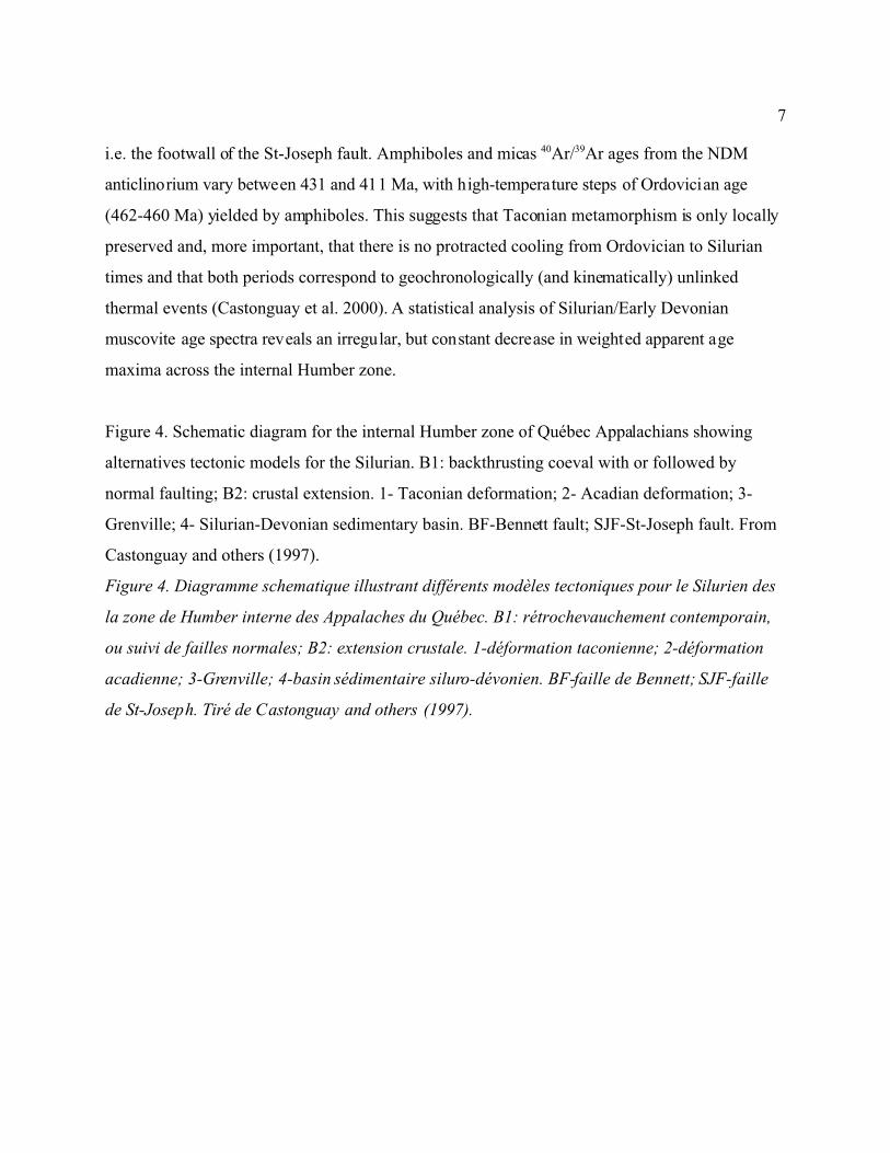
Figure 4. Schematic diagram for the internal Humber zone of Québec Appalachians showing
alternatives tectonic models for the Silurian. B1: backthrusting coeval with or followed by
normal faulting; B2: crustal extension. 1- Taconian deformation; 2- Acadian deformation; 3-
Grenville; 4- Silurian-Devonian sedimentary basin. BF-Bennett fault; SJF-St-Joseph fault. From
Castonguay and others (1997).
Figure 4. Diagramme schematique illustrant différents modèles tectoniques pour le Silurien des
la zone de Humber interne des Appalaches du Québec. B1: rétrochevauchement contemporain,
ou suivi de failles normales; B2: extension crustale. 1-déformation taconienne; 2-déformation
acadienne; 3-Grenville; 4-basin sédimentaire siluro-dévonien. BF-faille de Bennett; SJF-faille
de St-Joseph. Tiré de Castonguay and others (1997).

8
This age-decreasing trend is interpreted to result from the temporal (ca. 431-411 Ma) and
possibly spatial (from NW to SE) migration of deformation, recrystallization and fluid circulation
during backthrusting and extensional deformation. In the hangingwall of the St-Joseph fault,
metamorphic rocks of the Humber zone are locally exposed through Acadian structural outliers
and yielded Middle Ordovician 40Ar/39Ar muscovite ages (464-461 Ma; Whitehead et al. 1996,
Castonguay et al. 2000), which show no evidence for younger thermal overprint and are
consistent with high-temperature step ages of amphiboles from the footwall of the St-Joseph
fault.
Middle Ordovician ages are attributed to Taconian metamorphism related to crustal
thickening and are consistent with the inferred age of deformation in the Appalachian foreland
and external zone in Québec and New England (e.g. St-Julien and Hubert 1975, Stanley and
Ratcliffe 1985). For Silurian-Early Devonian ages and the associated hinterland-directed
deformation, Castonguay et al. (1997) have proposed two alternative models (Fig. 4), (i) a
backthrusting model in which metamorphic ages are related to the tectonic wedging of basement
rocks at depth that induced the formation of Silurian backthrusts, such as the Bennett fault,
followed by the collapse and the exhumation of the internal zone due to normal faults, and (ii) an
extension model in which the Bennett - St-Joseph faults depict a low-angle normal faults system
that has been rotated and folded in response to isostatic rebound during Silurian crustal
extension. Both models imply significant upper crustal extension and provide structural
mechanisms and timing contraints that are compatible with the deposition of Silurian and Early
Devonian deposits (i.e. the Gaspé Belt) currently fringing the Humber zone. During the Acadian
orogeny, the collision between Laurentian with an Avalonian continental terrane contributed to
superimposed metamorphism and deformation.

9
FIELD TRIP ROAD LOG
The field trip is a section between Quebec City and St-Joseph-de-Beauce with two
complementary stops in the Thetford-Mines area (Fig. 1). It focuses on the structural
characteristics of the external and internal Humber Zone. Stops 1 and 9 are located on figure 1,
stops 2 to 6 are on figure 5, and stops 7-8 are on Figure 14. Figure 6 shows a simplified structural
profile of the transect.
STOP 1: THE EXTERNAL HUMBER ZONE: thrust faults and folds of the Chaudière
nappe.
Location: From Quebec city, take Highway #73 South. After ca 7 km, take the exit to
Saint-Etienne-de-Lauzon. At the intersection with road 171, turn left and drive for ~6 km. There
is a rest area on the left side of the road. Park your vehicle. The outcrop is along the Chaudière
River just in front of the rest area.
Stratigraphy and structural setting: In Cambrian and Ordovician time, the passive
margin sedimentation in the Québec reentrant is recorded by carbonate and siliclastic slope and
rise deposits preserved in the Appalachian allochtons (Fig. 1). Sedimentary facies consist of four
principal successions; 1- Lower - Middle Cambrian red and green shales, green sandstones and
some carbonates; 2- Upper Cambrian black mudslates, white quartzites and conglomerates with
carbonate clasts; 3- Lower to Middle Ordovician slope deposits; 4- Upper Middle Ordovician
flysch deposits.
The external Humber Zone is bounded by the Logan's line to the NW, and by the
Richardson fault to the SE (Fig. 1; St-Julien and Hubert, 1975). South of the Chaudière River,
the Richardson fault is not precisely located, and the external-internal boundary corresponds to a
major backthrust fault of the southern Québec Appalachians, the Bennett fault (Pinet et al.,
1996a). Within the external zone, the regional deformation is mostly characterized by west-
directed thrust faults and folds, and by a regionally-developed schistosity (S1).
Field description: The lithologies exposed at this outcrop consist of a sequence of green
sandstones, locally up to 2-3 metres thick, interbedded with red mudslates and minor, thinly-

12
bedded limestones. The outcrop exposes a major zone of thrust faulting and related folding
within the Chaudière nappe. Thrust faults are sub-horizontal or slightly inclined east or southeast,
and marked by cm- to metre-thick zones of cataclastic brecciation and brittle/ductile deformation.
The shear-related foliation is well-developed and is hosting down-dip striations and slickenlines.
Locally well-developed C/S fabrics clearly indicate west- to NW-verging faulting. Asymmetrical
tight to isoclinal folds are nicely exposed in the hangingwall of thust faults (Fig. 7).
Regional implications: The Chaudière nappe is limited by a major thrust fault and forms
a klippen that represents the highest structural element of the Québec Allochtons (St-Julien,
1995). The external Humber Zone consists of sub- greenschist, fine to coarse-grained, mainly
siliciclastic and calcareous rocks of Late Cambrian to Middle Ordovician age. The thrust-
imbricated nappes form east-dipping duplex sequences and depict a typical foreland succession
that was deformed in Late Ordovician time. Age constraints from correlative rocks of New
England suggest that the tectonic emplacement of the Taconian allochthons and their subsequent
metamorphism have occurred between 455 and 440 Ma (Hames et al., 1991; Armstrong et al.,
1992).
STOP 2: THE EXTERNAL HUMBER ZONE: superposed folding in the hangingwall of
the Bennett fault.
Location: Follow road 171 East up to Saint-Lambert-de-Lévis. Turn left at the
intersection with road 218 and follow the direction to Highway 73. Follow the highway 73 South
for ~25 km and take the exit to Sainte-Marie-de-Beauce. Turn left and drive back on Highway 73
North. The outcrop is a roadcut, on the right side of the road, at 800 m from the Sainte-Marie-de-
Beauce highway entrance.
Structural setting: Along the Chaudière River transect (Figs. 5 and 6), the Chaudière
nappe structurally overlies different rock units belonging to various nappes. This outcrop is
located within the St-Maxime nappe (St-Julien, 1995) that is essentially made up of red-and-
green slates and mudslates interbedded with sandstones, conglomerates and limestone
conglomerates. The Richardson fault belongs to a northwest-directed D1-2 thrust fault system
(Tremblay and Pinet, 1994). Fifteen kilometres north of the Chaudière River, the Richardson
13
fault is folded by a NE-plunging, SE-verging anticline (Fig. 1, Vallieres, 1971) which we
attribute to a D3 deformational event related to backthrusting. Rock units of the eastern limb of
the anticline are in inverted position and exhibit a NW-dipping S3 cleavage which overprints the
dominant schistosity. Field description: From NW to SE, exposed lithologies are 1) red and
green siltstones, 2) conglomerates with quartz pebbles and limestone clasts. Quartz fragments are
well-rounded with a maximum size of 2-4 cm, whereas limestone fragments are angular, grey to
black in color, and up to 1 metre in diameter. Graded-bedding clearly indicate an inverted
polarity. 3) Black siltstones and shales with grey quartzitic beds; the transition with unit 2 is
gradual and several conglomeratic horizons are present at the base of unit 3 (Fig. 8).
The dominant fabric is a NE-trending schistosity that is overprinted by a NW-dipping
crenulation cleavage (regional S3). Folds associated with both fabrics can be found. S3 is
regionally-developed and associated with SE-verging folds. Structural relations between the
various fabrics and the inverted polarity of the sequence indicate that this site is located
on the eastern flank of an overturned anticline on the hangingwall of the Bennett fault.
Regional implications: Fabrics formed during the westward emplacement of
Taconian nappes were overprinted by SE-verging folds and faults of inferred Silurian age
(Castonguay et al., 1997; 2000). The Richardson fault, which marked the external-internal
boundary of the Taconian orogen in southern Québec, is folded by similar backfolds (Fig. 6).
STOP 3: THE INTERNAL HUMBER ZONE: metamorphic rocks in the footwall of the
Bennett fault.
Location: Continue northward, take the next exit and drive back to Highway 73 South
(Fig. 5). On your way, note when you cross the Chassé River near Sainte-Marie-de-
Beauce. The outcrop is a roadcut on the left side of the road, at 4.3 km south of the bridge over
the Chassé River.
Stratigraphic and structural setting: In the internal Humber Zone, the Caldwell Group
is mostly made up of quartzo-feldspathic sandstones interbedded with red and green slates and
with lava flows (St-Julien 1987, Cousineau 1990), and is conformably overlain by quartzites and
black shales of the Rosaire Group. Following Vallieres (1984), we correlate the Caldwell and

15
Rosaire groups respectively with the St-Roch (Early Cambrian) and the Trois-Pistoles groups
(Late Cambrian to Early Ordovician) which belong to the external Humber Zone.
The internal Humber Zone encompasses the Sutton Mountains and Notre-Dame
Mountains anticlinoria. Regional structures (D1-2) of the internal Humber Zone are overprinted by
a penetrative crenulation cleavage (D3), axial-planar to SE-verging folds, and closely associated
to SE-directed backthrusts mainly represented by the Bennett fault (Fig. 6; Pinet et al., 1996b).
Field description: The outcrop exposes metamorphic lithologies that are divided into
two principal assemblages: Rosaire-type, black-and-rusty phyllites and quartzites in the eastern
half, and Caldwell-type green-and-red phyllites and metasandstones in the western half. The
dominant fabric is the backthrust-related, penetrative foliation associated to SE-verging isoclinal
folds and shear planes (Fig. 9). Refolded folds (sheath folds?) can be locally seen (Fig. 9).
Asymmetrical structures, such C/S fabrics, shear bands and quartz porphyroclasts attest for
hinterland-directed movement. Less penetrative, NW-dipping shear zones are present. Note the
strong contrast in intensity of deformation and metamorphism compared to the previous outcrop.
Regional implications: D3 fabrics of the Chaudière River area are regionally developed
and correspond to backthrust structures as described by Colpron (1990) and Tremblay and Pinet
(1994). Along the western limb of the Sutton-Notre-Dame mountains anticlinorium, these
structures root within the Bennett fault (Fig. 6) and the correlative Brome thrust (Colpron, 1990).
Shear-sense indicators and the overall vergence of F3 folds indicate southeast-directed motion.
STOP 4: THE INTERNAL HUMBER ZONE: the core of the Notre-Dame anticlinorium.
Location: Continue on Highway #73 South. The next stop is a roadcut located 2.4 km
south of the exit to Vallée-Jonction (see Fig. 15).
Structural setting: Within the Sutton-Notre-Dame Mountains anticlinorium (SNMA),
there is evidence for four generations of structures. The regional schistosity is a NW-SE striking
S1-2 composite foliation, axial-planar to F2 isoclinal folds associated with NW-SE trending
stretching lineations. D1-2 fabrics and structures were refolded by tight to isoclinal recumbent F3
folds that are associated with a flat-lying foliation (S3). F3 folds vary in orientation from slightly
plunging toward the northeast or the southwest. They are frequently coaxial with older folds and

16
lineations (NW- or SE-plunging), although they clearly refolded D2-related planar and linear
fabrics. All structures were then refolded by NE-SW trending, upright open folds (F4) associated
with the development of the SNMA. A syn-D4 planar fabric is observed across the anticlinorium.
From NE to SW, it varies from a fracture cleavage (Notre-Dame Mountains anticline) to a
penetrative crenulation cleavage (Sutton Mountains anticline).
Field description: The outcrop exposes lithologies included in the Rosaire Group. It
consists of dark grey, massive quartzite beds and black and rusty pelitic schists. Quartz veins are
abundant both in the quartzites and the pelitic schist. The dominant schistosity is subhorizontal
and axial-planar to recumbent folds (Fig. 10). A discrete but well-developed series of SE-dipping
normal-sense shear planes are visible and crosscutt the dominant schistosity.
Regional implications: Foreland- and hinterland-verging structures are refolded by NE-
SW trending upright open folds (F4) which have been attributed to the Acadian development of
the Sutton-Notre-Dame mountains anticlinorium (Tremblay and Pinet, 1994a). The SNMA is the
most prominent, large-scale structural feature of the internal Humber zone of southern Québec. It
is defined by doubly-plunging anticlinoria that are bounded in the Thetford-Mines and Chaudière
River areas by the St-Joseph fault to the east, and in the core of which are found the highest grade
metamorphic rocks of the Taconian orogen. The Chaudière River area is, however, located at a
periclinal termination of the SNMA, and exposes a higher structural level of the Taconian
orogenic wedge than those cropping out within the anticlinorium.
STOP 5: THE INTERNAL HUMBER ZONE: extensional structures in the footwall of the
St-Joseph fault.
Location: Continue to follow Highway #73 South. The next stop is a roadcut located 3
km south of the previous outcrop (see Fig. 5).
Structural setting: In the Chaudière River area, the St-Joseph fault (Pinet et al., 1996b)
is interpreted as a major normal fault within the internal Humber Zone. The fault strikes NE-SW
and separates similar rock units that have recorded different structural and metamorphic histories.
Metamorphic rocks of the footwall are characterized by well-developped polydeformed fabrics
and structures. Rock units of the hanging wall are less deformed and are found in normal or

17
inverted position. The most striking evidence for SE-directed normal motion comes from several
quarries located in the Thetford Mines area, along the NW-SE trending branch of the Pennington
ultramafic sheet (Kirkwood and Tremblay, 1994). We will observe well-developped extensional
fabrics that are found up to 4 km to the northwest of the St-Joseph fault. (Fig. 6).
Field description: In this outcrop, two rock packages are recognized, 1) to the NW, light
grey to greenish siltstones and sandstones that are attributed to the Caldwell Group, and 2) to the
SE, black shales and quartzites that belong to the Rosaire Group. Near the contact between 1)
and 2), a 1,5 metre-thick high strain zone is marked by numerous quartz veins. Well-developed
extensional fabrics are exposed SE of the contact, and consist of asymmetrically boudinaged
quartz veins and metre- to decimetre-spaced, SE-dipping (30-70o) brittle-ductile shear zones (Fig.
11). Quartzite beds are clearly affected by SE-verging folds that are associated with an axial-
planar schistosity.
The relationship between SE-dipping shears and folds is not clear, and the latter can be
interpreted either as overprinted backfolds, or as structures genetically related to normal faulting.
Crosscutting relationships shown by the dominant foliation with both the extensional and sheared
quartz veins (Fig. 12), however, suggest that all these structures have been generated during a
SE-verging deformational event.
Regional implications: The recognition of normal faults of inferred Silurian/Early
Devonian age (Castonguay et al., 1997; 2000) in the internal zone of the Taconian orogen
provides a mechanism for the deposition of thick sequences of Silurian and Devonian rocks
preserved in large sedimentary basins such as the Connecticut Valley-Gaspé trough (see Fig. 7).
STOP 6: THE INTERNAL HUMBER ZONE: the hangingwall of the St-Joseph fault.
Location: Follow Highway #73 South and take the exit to St-Joseph-de-Beauce. Turn left
on road 276 North (toward Lac-Etchemin) and take the entrance back on 73 North. The outcrop
is a roadcut that is accessible via a construction road that is the southward continuation of
Highway 73.
Structural setting: In the hangingwall of the St-Joseph fault (Fig. 5), rocks that belong to
the Caldwell and Rosaire groups are less deformed than in the footwall. Primary textures and

19
structures such as graded-bedding and massive or pillowed lava flows are well-preserved, in
marked contrast with rock units present in the footwall of the St-Joseph fault.
Field description: The outcrop exposes typical sandstones and red-and-green shales of
the Caldwell Group. Note the lithological similarity with the sedimentary sequence of the
Chaudière nappe as seen at stops 1 and 2. Well-developed antiformal upright folds can be seen
(Fig. 13), and are associated to a NE-SW trending, axial-planar cleavage.
Gradded-bedding and cross-laminations in sandstone beds indicate that the sequence is
up-side-down. This regional feature implies the presence of pre-existing, recumbent folds in the
Caldwell/Rosaire sequence, east of the St-Joseph fault. Regional constraints suggest that the
superposed upright folding is Acadian-related, and that pre-existing recumbent folding should be
pre-Acadian. Such folds probably belong to the SE-verging folding phase (D3) recognized in the
footwall of the St-Joseph fault.
Regional implications: Even tough the existence of normal-sense metamorphic break
does not necessarily imply crustal extension (e.g. Wheeler and Butler, 1994), it is important to
note that the St-Joseph fault also coincides with a strong metamorphic and structural contrast
(compare this stop with stops 3 to 5).
STOP 7: THE ST-JOSEPH FAULT
Location: Take the bridge over the Chaudière river in St-Joseph-de-Beauce, turn right.
Turn left on the next road and follow it until the intersection with road 112 (~6 km). Turn left on
road 112 West, and drive for ~15 km. At the intersection with road 271 South, turn right on rang
IX. The outcrop is a quarry that is located on your left at 1 km from road 112. Contact Carey
Canada Inc. for the permission to access the site.
Structural setting: The St-Joseph fault is clearly recognized over a distance of
approximately 200 km from Thetford-Mines to the Québec-Maine border in the northeast (Fig.
1). Existing geological maps of the Chaudière River area show the St-Joseph fault as a thrust
fault (St-Julien, 1987; Cousineau, 1990). In the Thetford-Mines area (Fig. 14), the fault is
commonly marked by slivers of sheared serpentinites and follows the NE-SW trending branch of
the Pennington ultramafic sheet (St-Julien, 1987). The St-Joseph fault dips approximatively 70o
21
toward the southeast.
Field description: The St-Joseph fault is exposed in the quarry and is marked by
serpentinite slivers (Fig. 15). The footwall consist of dark-colored, finely laminated “gneissic”
rocks and chlorite schists showing multiple generations of fabrics and complex fold
interferences. The hangingwall rocks are dark quartzites interbedded with pelitic and quartz-
sericite schists with abundant quartz veins and veinlets parallel to the mylonitic foliation.
Abundant shear bands and SE-verging folds in the footwall clearly attest for normal-sense
motion. Serpentinite in the fault zones is most commonly scaly. In this quarry, the St-Joseph fault
corresponds to a series of interfering low-angle and high-angle, ductile/brittle normal faults (Fig.
15). We interpret the former structures as low-angle synthetic shear zones formed during
progressive deformation. Extensional faulting has been localized by the serpentinite layers
which probably flowed up- and down-dip along fault planes.
Regional implications: Structures related to the St-Joseph fault are superposed on
Silurian SE-verging folds (F3) of the footwall (Castonguay et al., 1997), thus indicating that
normal faulting post-dates backthrusting, and excluding the possibility that this normal fault is a
rotated backthrust or a reimbricated D1-2-related thrust. In southern Québec, the recognition of
extensional structures related to the St-Joseph fault is important and indicates that an extensive
system of normal faults developed prior to the Acadian orogeny. Southward, the St-Joseph fault
merges with the BBL on both side of which similar metamorphic and structural contrasts occur.
40Ar/39Ar dating of metamorphic rocks from the footwall of the BBL bordering the Sutton
Mountains anticlinorium also yielded Silurian ages (Castonguay, unp. data) and field data also
indicate the predominance of southeast-dipping normal sense faulting. Northward, the St-Joseph
fault merges into an unamed normal faults system mapped at the boundary between the CVG
trough and pre-Silurian rocks in northwestern Maine (e.g. Osberg et al. 1985). This suggests that,
from southern Québec to northwestern Maine, the St-Joseph fault is part of an extensively
developped, normal fault system of probably Late Silurian to Early Devonian age that extends for
more than 400 km. We suggest that evidence for extensional deformation has been locally
preserved within the Québec reentrant because this segment of the Taconian orogen has suffered
less intense Acadian deformation and metamorphism than elsewhere in the Appalachian belt.
23
STOP 8: ULTRAMAFIC ROCKS OF THE INTERNAL HUMBER ZONE: the
Pennington Sheet.
Location: Drive back to road 112 West. At the intersection with Rang X, turn right
toward St-Pierre-de-Broughton. Follow this road for 4 km and park your vehicule. The outcrop is
located in the field on the south side of the road. Ask for permission to the owner of the land.
Structural setting: The Pennington Sheet is a fault zone (D2?) within the Bennett Schist
(Kirkwood and Tremblay, 1994) (Fig. 14). The NW-SE trending branch of the Pennington Sheet
is characterized by mylonitized and brecciated serpentinite that is deformed by the regional D3
and D4 structures, whereas the SE portion of the ultramafic sheet is truncated by the St-Joseph
fault. Mapping in correlative rocks of southernmost Québec (Colpron, 1990; Rose, 1993), New
England (Stanley and Ratcliffe, 1985) and Newfoundland (Hibbard, 1983) has shown the
existence of fault zones similar to the Pennington Sheet.
Rocks adjacent to the Pennington Sheet belong to the Rosaire and Caldwell groups and to
their metamorphic equivalents in the Bennett Schist. These rocks consist of quartzite, pelitic
schist, and quartz-albite-muscovite-chlorite+/-biotite schist.
Field description: At this locality, the contact between the Pennington Sheet and
adjacent metamorphic rocks can be observed. Host rocks are graphitic schists, quartzites and
micaschists which are characterized by isoclinal folds, coaxial with well-developed quartz rods
and mineral lineations. The ultramafic sheet is a foliated ophiolitic mélange. Most fragments are
serpentinized dunite and harzburgite. The outcrop locally shows nice examples of progressive
tectonic brecciation. Two generations of structural fabrics can also be observed. 40Ar/39Ar
muscovite dating from adjacent metamorphic rocks yielded a plateau age of 425+/-2Ma
(Castonguay et al., 1997) which has been attributed to the backthrusting thermal imprint.
Regional implications: The geometry and tectonic significance of the Pennington Sheet
are still not well understood. On map scale, these ultramafic rocks make complex fold patterns
and it is not excluded that the sheet has been folded by D2 structures as well. The link between
the Pennington Sheet and the Thetford-Mines ophiolitic complex (Fig. 14) is not clearly
established. According to the actual knowledge of the regional geology, we believe that
structures such as the Pennington Sheet are most probably related to pre- to syn-D2 ductile

24
shearing within the Laurentian margin.
STOP 9: BACKTHRUST STRUCTURE AND METAMORPHISM: The Bernierville
section.
Location: Drive back and follow road 112 West across Thetford-Mines and to Black
Lake (~22 km). In Black Lake, turn right on road 265 North and drive for ca. 17 km. Take the
entrance to Bernierville. The outcrop the roadcut adjacent to that entrance.
Stratigraphy and tectonic framework: In the external Humber zone, the Oak Hill
Group forms a complete rift- and drift-related sequence of the Laurentian margin. It records the
progressive development of a continental margin from Early Cambrian to early Middle
Ordovician time (Charbonneau,1980; Colpron, 1990; Marquis, 1991). The Oak Hill Group
consists of volcanic rocks, calcareous rocks, quartzites and slates. The age of the volcanics
(Early Cambrian) is defined by U/Pb zircon ages from the Tibbit Hill Formation (554 Ma;
Kumarapeli et al., 1989). The age of the upper part of the Oak Hill Group is believed to be late
Arenigian to early Llanvirnian on the basis of conodonts (Marquis and Nowlan, 1991).
The Bennett Schist of the internal Humber Zone consist of metamorphosed rocks of the
Oak Hill, Caldwell and Rosaire goups. Several generations of structures are recognized. The
regional schistosity (S1-2) is overprinted by a S3 crenulation cleavage. Variations in the intensity
of D3 fabrics reflect the inhomogeneous strain pattern during this deformation. D3 high strain
zones correspond west-dipping shear zones, such as the Bennett fault (Pinet et al., 1996a),
developed along flanks of large-scale SE verging antiforms.
Field description: Several deformational events are recognized in this outcrop. The
oldest structural fabric (S1-2) is defined by a compositional layering. Metamorphism associated to
D1-2 structures is of upper greenschist facies as indicated by mineral assemblages which comprise
biotite and muscovite. The presence of biotite has been attributed to the proximity of a D1-2
faulted contact between the lower Oak Hill Group (Tibbit Hill Formation) with its upper units
(Fig. 16). D1-2 structures are overprinted by a mm-spaced S3 crenulation cleavage which is
marked by the recrystallisation of muscovite. Shear sense indicators related to D3 and the
vergence of associated folds suggest a hinterland-directed tectonic transport. Biotite and
26
muscovite 40Ar/39Ar dating from this outcrop yielded Silurian ages (Castonguay et al. 2000).
Regional implications: In southern Québec, the internal Humber Zone records
backthrusting structures of Silurian age that are poorly documented (or absent?) in correlative
rocks of the New England Appalachians. On the basis of seismic reflection data from southern
Québec (St Julien et al., 1983), the existence of basement duplexes is inferred at depth under the
Sutton-Notre-Dame Mountains anticlinorium (Bardoux and Marquis, 1989). Backfolds and
backthrusts of the internal zone has been consequently interpreted as resulting from the tectonic
wedging of basement rocks (Pinet et al., 1996a).
This marks the end of the field trip. Beer and chatting time!!
REFERENCES
Armstrong, T.R., Tracy, R.J. and Hames, W.E. 1992, Contrasting styles of Taconian, Eastern
Acadian and Western Acadian metamorphism, central and western New England. Journal
of metamorphic Geology 10: 415-426.
Bardoux, M. and Marquis, R. 1989. L2001: a new interpretation of NW-dipping reflectors above
the basement-cored Sutton-Notre-Dame anticlinorium near Thetford-Mines. Appalachian
Workshop, University of Vermont, p. 50.
Boone, G.M. and Boudette, E.L. 1989, Accretion of the Boundary Mountains terrane within the
northern Appalachians orthotectonic zone. Geological Society of America Special Paper
228, p. 17-42.
Bourque, P.A., Brisebois, D. and Malo, M., 1995, Middle Paleozoic rocks of Québec and
adjacent New Brunswick: in Williams, H., editor, The Appalachian-Caledonian Region:
Canada and Greenland: Decade of North American Geology, volume F-1.
Castonguay, S.; Tremblay, A.; Ruffet, G.; Féraud, G.; Pinet, N.; and Sosson, M., 1997,
Ordovician and Silurian metamorphic cooling ages along the Laurentian margin of the
Québec Appalachians: bridging the gap between New England andNewfoundland:
Geology 25: 583-586.
Castonguay, S., Ruffet, G., Tremblay, A. & Féraud, G. 2000. Tectonometamorphic evolution of
27
the southern Quebec Appalachians: 40Ar/39Ar evidence for Ordovician crustal thickening
and Silurian exhumation of the internal Humber zone. Géological Society of America
Bulletin (in review).
Cawood, P.A.; Dunning, G.R.; Lux, D.; and van Gool, J.A.M., 1994, Timing of peak
metamorphism and deformation along the Appalachian margin of Laurentia in
Newfoundland: Silurian not Ordovician: Geology 22: 399-402.
Cawood, P.A.; van Gool, J.A.M.; and Dunning, G.R., 1995, Collisional tectonics along the
Laurentian Margin of the Newfoundland Appalachians, in Hibbard, J.P., van Staal, C.R.,
and Cawood, P.A., eds, Current Perspectives in the Appalachian-Caledonian Orogen:
Geol. Ass. Can. Spec. Pap. 41, p. 283-301.
Charbonneau, J.-M. 1980, Région de Sutton-West. Ministère de l’Énergie et des Ressources,
Québec, DPV-681, 89 pages.
Colpron, M., ms. 1990, Rift and collisional tectonics of the Eastern Townships Humber Zone,
Brome Lake area, Québec: [M.S. Thesis], University of Vermont, Burlington..
Cousineau, P.A., 1990, Le Groupe de Caldwell et le domaine océanique entre St-Joseph-de-
Beauce et Ste-Sabine: Ministère de l'Energie et des Ressources, Québec, MM 87-02, 165
pages.
Dunning, G.R.; O’Brien, S.J.; Colman-Sadd, S.P.; Blackwood, R.F.; Dickson, W.L.; O’Neill,
P.P.; and Krogh, T.E., 1990, Silurian orogeny in the Newfoundland Appalachians:
Journal of Geology 98: 895-913.
Hames, W.E., Tracy, R.J., Ratcliffe, N.M. and Sutter, J.F., 1991, Petrologic, structural, and
geochronologic characteristics of the Acadian metamorphic overprint of the Taconide
zone of southwestern New England. American Journal of Science, 291: 887-913.
Hibbard, J.P., 1983, Geology of the Baie Verte Peninsula, Newfoundland: NFL Dep. Mines
Energy, Min. Dev. Div., Memoir 2, 279 pages.
Hibbard, J.P.; St-Julien, P.; and Trzcienski, W.E.Jr, 1995, Humber Zone internal, in Williams,
H., ed, Geology of the Appalachian/Caledonian Orogen in Canada and Greenland,
Chapter 3: Geol.Surv. Can., Geology of Canada, no. 6, p. 114-139 (also Geol. Soc.
America, The Geology of North America, v. F-1).

28
Karabinos, P., Samson, S.D., Hepburn, J.C., and Stoll, H.M., 1998, Taconian orogeny in the New
England Appalachians: collision between Laurentia and the Shelburne Falls arc. Geology,
26: 215-218.
Kirkwood, D. and Tremblay, A. 1994. Structural and geometrical analysis of the Bennett schist,
Taconic internal zone, Québec Appalachians [abs.]. Geological Society of
America, NE section meeting, Abstracts with programs, v. 26, p. 29.
Kumarapelli, P.S., Dunning, G.R., Pintson, H. and Shaver, J. 1989, Geochemistry and U-Pb
zircon age of commenditic metafelsites of the Tibbit Hill Formation, Québec
Appalachians. Canadian Journal of Earth Sciences 26: 1374-1383.
Laird, J., 1988. Arenig to Wenlock age metamorphism in the Appalachians. In A.L. Harris, and
D.J. Fettes (Editors), The Caledonian-Appalachian Orogen. Geol. Soc. Sp. Publ. 38, pp.
311-345.
Marquis, R. 1991, Géologie de l’anticlinorium des Monts Sutton (région de Richmond), Québec.
Ministère de l’Énergie et des Ressources, Québec, ET 89-02, 86 pages.
Marquis, R. and Nowlan, G.S. 1991. Stratigraphic position and conodonts of the early Middle
Ordovician Melbourne Formation, Québec. Canadian Journal of Earth Sciences 28: 816-
821.
Osberg, P.H. 1978, Synthesis of the geology of northeastern Appalachians, U.S.A.: in
Caledonian-Appalachian orogen of the North Atlantic region, Geological Survey of
Canada Paper 78-13, p. 137-147.
Osberg, P.H., Hussey, A.M. II, and Boone, G.M. (Editors), 1985, Bedrock Geologic Map of
Maine. Maine Geol. Surv., map scale 1:500,000.
Osberg, P.H., Tull, J.F., Robinson, P., Hon, R. and Butler, J.R., 1989, The Acadian orogen, in
Hatcher, R.D.Jr, Thomas, W.A. and Viele, G.W., editors, The Appalachians-Ouachita
orogen in the United States: The Geology of North America, v. F-2, p. 179-232
Pinet N., and Tremblay, A., 1995, Tectonic evolution of the Québec-Maine Appalachians: from
oceanic spreading to obduction and collision in the northern Appalachians. American
Journal of Science 295: 173-200
Pinet, N., Castonguay, S. and Tremblay, A. 1996a. Thrusting and backthrusting in the

29
Taconian internal zone, southern Quebec Appalachians. Canadian Journal of Earth
Sciences 33: 1283-1293.
Pinet, N., Tremblay, A. and Sosson, M. 1996b. Extension versus shortening models for
hinterland-directed motions in the southern Québec Appalachians..Tectonophysics 267:
239-256.
Ratcliffe, N. M., Hames, W. E., and Stanley, R. S., 1998. Interpretation of ages of arc
magmatism, metamorphism, and collisional tectonics in the Taconian orogen of western
New England. Am. J. Sci., 298: 791-797.
Robinson, P., Tucker, R. D., Bradley, D., Berry, H. N., IV, and Osberg, P. H., 1998. Paleozoic
orogens in New England, USA: Trans. Geol. Soc. Stock., GFF (Geol. Soc. Swed.) , v.
120, pp. 119-148.
Rose, H. 1993, Stratigraphy, characterization of metavolcanic rocks and structural
evolution in a cross-section through the Taconide zone, internal domain, Eastern
Townships, southern Québec: regional implications: [M.Sc. Thesis]: University of
Vermont, Burlington.
Stanley, R.S., and Ratcliffe, N.M., 1985, Tectonic synthesis of the Taconian orogeny in western
New England. Geological Society of America Bulletin 96: 1227-1250.
St-Julien, P., 1995, Géologie de la région de Québec. Ministère des Ressources Naturelles,
Québec, MB 94-40, 62 pages.
St-Julien, P., 1987, Géologie des régions de Saint-Victor et de Thetford Mines (moitié est).
Ministère de l'Energie et des Ressources, Québec, MM 86-01, 66 p.
St-Julien, P., 1995, Géologie de la région de Québec. Ministère des Ressources Naturelles,
Québec, MB 94-40, 62 pages.
St-Julien, P., and Hubert, C., 1975, Evolution of the Taconian orogen in the Québec
Appalachians. American Journal of Science 275-A: 337-362.
St-Julien, P., Slivitzky, A., and Feininger, T. 1983, A deep structural profile across the
Appalachians of southern Québec. Geological Society of America Memoir 158, p. 103-
112.
Sutter, J.F., Ratcliffe, N.M., and Musaka, S.B., 1985. 40Ar/39Ar and K/Ar data bearing on the
30
metamorphic and tectonic history of western New England. Geol. Soc. Am. Bull., 96:
123-136.
Tremblay, A. 1992, Tectonic and accretionary history of Taconian oceanic rocks of the
Québec Appalachians. American Journal of Science 292: 229-252.
Tremblay, A., and Pinet, N., 1994, Distribution and characteristics of Taconian and Acadian
deformation, southern Québec Appalachians. Geological Society of America Bulletin
106: 1172-1181.
Tremblay, A., Bédard, J.H. and Lauzière, K., 1997. Taconian obduction and Silurian exhumation
of the Betts Cove Ophiolite, Canadian Appalachians. The Journal of Geology 105: 701-
716.
Tremblay, A., Ruffet, G. and Castonguay, S. 1999. Acadian metamorphism in the Dunnage zone
of southern Québec, Northern Appalachians: 40Ar/39Ar evidence for collision
diachronism. Geological Society of America Bulletin, sous presse.
Trzcienski, W.E. Jr., Rodgers, J. and Guidotti, C.V. 1992. Alternative hypotheses for the
Chain Lakes Massif, Maine and Québec. American Journal of Science 292: 508-532.
Vallières, A., 1971, Relations stratigraphiques et structurales du Supergroupe de Québec dans la
région de St-Malachie ouest. M.Sc. Thesis, Université de Montréal, Montréal.
Vallieres, A, 1984, Stratigraphie et structure de l’orogène taconique de la région de Rivière-du-
Loup, Québec: [Ph.D. Thesis], University Laval, Québec.
van Staal, C.R., and de Roo, J.A., 1995. Mid-Paleozoic tectonic evolution of the Appalachian
Central Mobile Belt in northern New Brunswick, Canada: collision, extensional collapse
and dextral transpression. In: J.P. Hibbard, C.R. van Staal, and P.A. Cawood (Editors),
Current Perspectives in the Appalachian-Caledonian Orogen. Geol. Ass. Can. Sp. Pap.
41, pp. 367-389.
van Staal, C.R., Ravenhurst, C.E., Winchester, J.A., Roddick, J.C. and Langton, J.P. 1990, Post-
Taconic blueschist suture in the Northern Appalachians of northern New Brunswick.
Geology 18: 1073-1077.
Wheeler, J. and Butler, R. W. H., 1994, Criteria for identifying structures related to true crustal
extension in orogens. Journal of Structural Geology 16: 1023-1027.
31
Whitehead, J., Reynolds, P.H., and Spray, J.G., 1996. 40Ar/39Ar constraints on Taconian and
Acadian events in the Québec Appalachians. Geology 24: 359-362.
Williams, H. 1979, The Appalachian orogen in Canada. Canadian Journal of Earth Science 16:
792-807.
Williams, H. and Hatcher, R.D.Jr, 1983, Appalachian suspect terranes: Geological Society of
America Memoir 158, p. 33-53.
Williams, H., and St-Julien, P., 1982, The Baie Verte-Brompton Line - Early Paleozoic
continent-ocean interface in the Canadian Appalachians: Geological Association of
Canada Special Paper 24, p. 177-208.