Embed Size (px)
DESCRIPTION
Basic irrigation ideas
Citation preview

Chapter 1 – Introduction, importance and methods of Irrigation
Topics to be addressed in this chapter Definition of Irrigation Purpose / Objective of Irrigation Necessity of Irrigation Advantages and ill-effects of irrigation Scope of Irrigation Science Methods of Irrigation Involvement of person with irrigation engineering Considerations for development of an irrigation project Irrigation project survey / report

Chapter 1 – Irrigation Canal

Chapter 1 – Definition of Irrigation
Definition of Irrigation Irrigation is the science of supplying water to the plants
for its growth and maturity i.e. the science of artificial application of water to the land, in accordance with the crop requirements throughout the crop period for full-fledged nourishment of the crops. It also can be defined as the application of water to soil for the purpose of supplying moisture which is essential for plant growth

Chapter 1 – Definition of Irrigation
Fulll Irrigation: When all the moisture or water that is required for crop is supplying artificially then the irrigation is termed as full irrigation. Full irrigation needed in dry season
Partial Irrigation: When some of the moisture or water in addition with natural water is artificially supply for the growth of crop then this type of irrigation is termed as partial or supplimentary irrigation. Partial / supplementary irrigation needed in rainy season

Chapter 1 – History of Irrigation
Started in ancient civilization in arid and semi-arid climatic zones where food shortage was acute
Old cities excavated in Asia and Africa have disclosed that more than 5000 years ago people in Lebanon, China, Indo-Pakistan, Egypt adopted a permanent irrigation canal system. They knew that without digging canals and taking water from rivers through canals, land cultivation was not possible

Chapter 1 – History of Irrigation
Chinese are known to have practiced irrigation since 2627 BC. They has the longest irrigation canal, known as the Grand Canal of 1285 miles, constructed originally by the Sui Empire during 589 to 618 AD and completed 1300 AD. This oldest and longest canal links Beijing and Hanchow by crossing the Great Yangzi and Yellow Rivers and still serving 159223 sq.km of area
One of the largest irrigation canal of North Kiangsu Province of China which is 170 km long and 127 m wide in bed was dug by 1300000 people in 80 days.

Chapter 1 – Objectives of Irrigation
Main purposes/objectives of irrigation To add water to soil To apply moisture essential for plant growth To provide crop insurance against short duration
droughts To cool the soil and atmosphere thereby making more
favorable environment for plant growth To wash out or dilute salts from the soil To reduce hazards of soil pipingSoften the tillage pan

Chapter 1 – Importance of Irrigation
Following are the factors which govern the importance/necessity of irrigation: Insufficient rainfall: when the total amount of rainfall is less than
the amount required by the plant i.e. demand of crop is more than rainfall in the area
Uneven distribution of rainfall: rainfall is sufficient but spatial distribution is not as per requirement
Rainfall is sufficient, spatial distribution is also good but temporal distribution is not as per requirement
Development of agriculture in desert area Due to advanced scientific development: for cultivation of high
yield variety

Chapter 1 – Advantages of Irrigation
Increased in food production Improvement of cash cropsSource of revenueGeneral prosperityGeneration of hydro-electric powerDomestic water supply Facilities of communications Inland navigationAfforestation

Chapter 1 – Indirect advantages
Increase value of propertyDevelopment of nutrition level Employment opportunity Industrial development with raw agricultural productRecreation facilitiesPolitical commitment

Chapter 1 – Disadvantages / ill-effects
Rising of water table: water-loggingSalinity and alkalinity of land Loss of manure (fertilizer) Loss of precious water which is developed and
preservedProblem of water pollution (nitrates: seepage into GW) Formation of marshy landDampness in weather Loss of valuable lands

Chapter 1 – Ill-effects of Water Logging
Normal cultivation operation such as tilling, ploughing etc can not be easily carried out in wet/watery soils
Certain water loving plants like grasses, weeds etc are grown and interfere with the growth of crops
Reduce yield/production: plant depends on nitrates which produced by bacteria, these bacteria needs O2for their servival. Water logging results the death of these bacteria which eventually reduce soil fertility

Chapter 1 – Causes of Water Logging
Over and intensive irrigationSeepage of water from the adjoining high landsSeepage of water through the canals Impervious obstruction Inadequate surface drainage Excessive rainsSurbergence due to flood Irregular or flat topography

Chapter 1 – Leaching
In this process, the land is flooded with adequate depth of water. The salt present in the soil, get dissolved in this water, which percolate downward to join the watertable or drained out by sub-surface drains. The process is repeated until the salts in the top layer of the land are reduced to such an extent that some salt resistant crop can be grown. This process is known as leaching.

Chapter 1 – Persons Involve in Irrigation
Following persons are closely related with irrigation engineering Hydrologist Agriculturist Soil scientist AdministratorMeteorologist Farmer Irrigation Planner Environmentalist Economist Social Scientist

Chapter 1 – Environmental Consideration
Following factors to be consideredSubmergence of land and forestryAtmospheric pollution for organic decompositionWater loggingMosquito habitalWater borne diseases

Chapter 1 – Method of Irrigation
Broadly classified into:Surface/Gravity Method (Soil surface is used to convey
water)Sub-surface irrigation (application of water beneath
the soil surface)

Chapter 1 – Surface Irrigation
In the surface methods of irrigation, water is applied directly to the soil surface from a channel located at the upper reach of the field.
Water may be distributed to the crops in border strips, check basins or furrows.
Two general requirements of prime importance to obtain high efficiency in surface methods of irrigation are: distribution systems to provide adequate control of water to the
fields proper land preparation to permit uniform distribution of water
over the field.

Chapter 1 – Surface Irrigation
They are also designed to minimize labor and capital requirements.
Effective management practices are dependent on the type of irrigation, and the climate and topography of the region.

Chapter 1 – Surface Irrigation

Chapter 1 – Surface Irrigation
Perennial Type: In perennial system of irrigation, constant and continuous water supply is assured to the crops in accordance with the requirements of the crop, throughout the ‘crop period’.
Flood Type: Soil is kept submerged and thoroughly flooded with water, so as to cause thorough saturation of the land. The moisture soaked by the soil, when occasionally supplemented natural rainfall or minor watering, brings the crop to maturity.

Chapter 1 – Subsurface Irrigation
In sub-irrigation, water is applied below the ground surface by maintaining an artificial water table at some depth, depending upon the soil texture and the depth of the plant roots
Water reaches the plant roots through capillary action Water may be introduced through open ditches or
underground through pipelines Water application system consists of field supply
channels, ditches or trenches suitably spaced to cover the field adequately and drainage ditches for the disposal of excess water.

Chapter 1 – Subsurface Irrigation

Chapter 1 – Subsurface Irrigation

Chapter 1 – Subsurface Irrigation
Natural Sub-irrigation: When underground irrigation is achieved, simply by natural processes, without any additional extra efforts, it is called natural sub-irrigation
Artificial Sub-irrigation: When a system of open jointed drains is artificially laid below the soil, so as to supply water to the crops by capillarity, then it is known as artificial sub-irrigation

Chapter 1 – Methods of surface irrigation
Free/Wild/Uncontrolled FloodingBorder FloodingCheck FloodingBasin Flooding Furrow Irrigation MethodSprinkler Irrigation MethodDrip Irrigation Method
Chapter 1 – Free Flooding
Free Flooding or Ordinary FloodingDitches are excavated in the field Water is applied from field ditches without any levee
to guide its flowMovement of water is not restricted, it is sometimes
called ‘wild flooding’ It is suitable for close growing crops It is practived large where irrigation water is abundant
and inexpansive

Chapter 1 – Free Flooding
Free Flooding or Ordinary Flooding It involves low initial cost of land preparation, extra
labour cost in application of water may required This method may be used on rolling land (topegraphy
irregular) where borders, checks, basins and furrow are not feasible
Application effieiency is lowNot a very scientific methodSince water is applied without any control, so one area
can be over-irrigated with respect to another

Chapter 1 – Free Flooding
Free Flooding or Ordinary Flooding

Chapter 1 – Free Flooding
Advantages Initial cost is very low
Disadvantages Not a scientific method Water loss is high Inefficient

Chapter 1 – Border Flooding
Border Flooding Land is divided into a number of strips Strips separated by low levees called ‘borders’ Strip area: width 10~20 m and length 100~400 m Water is turned from the supply ditch into these strips along
which a flow slowly toward the lower end, wetting the soil as it advances. When the advancing water front reaches the lower end, the stream turned off.
The surface is essentially level between levees and lengthwise slope is somewhat according to natural slope of the land (0.2 ~ 0.4%)
It is suitable to soils having moderately low to moderately high infiltration rates and to closely growing crops

Chapter 1 – Border Flooding
Border Flooding Uniform distribution and high water application efficiencies
than free/wild flooding are possible Large streams can be used efficiently This method involves high initial cost for land preparation Ridges between borders should be sufficiently high The land should be perpendicular to the flow to prevent
water from concentrating on either side of the border

Chapter 1 – Border Flooding
Border Flooding

Chapter 1 – Border Flooding
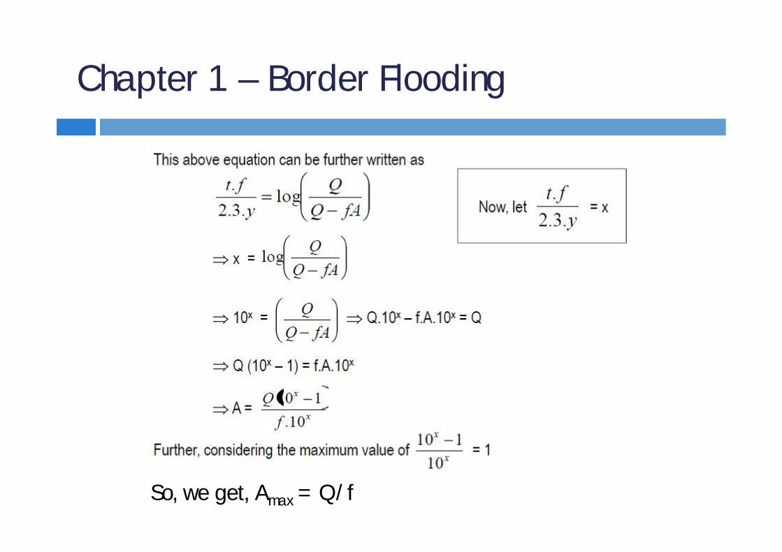
Time estimation for Border FloodingA relationship between the discharge through the supply ditch (Q), the average depth of water flowing over the strip (y), the rate of infiltration of the soil (f), the area of the land irrigated (A), and the approximate time required to cover the given area with water (t), is given by the equation
where,Q = Discharge through the supply ditchy = Depth of water flowing over the border stripf = Rate of infiltration of soilA = Area of land strip to be irrigatedt = Time required to cover the given area A

Chapter 1 – Border Flooding
Derivation of the equation
Considering small area, dA of the border strip of area ADepth of water, y over this area AAssume that in time dt, water advances over this area (dA)Now, the volume of water that flows to cover this area = y.dA ---------(1)

Chapter 1 – Border Flooding

Chapter 1 – Border Flooding
Chapter 1 – Border Flooding
So, we get, Amax = Q/f

Chapter 1 – Border Flooding
ProblemDetermine the time required to irrigate a strip of land of 0.04 hectares in area from a tubewell with a discharge of 0.02 cumec. The infiltration capacity of the soil may be taken as 5 cm/hr and the average depth of flow on the field as 10 cm. Also, determine the maximum area that can be irrigated from this tubewell.
Solution:Here, A = 0.04 ha = 0.04 x 10⁴ m2 = 400 m2
Q = 0.02 cumec = 0.02 m3/s = 0.02 x 60x 60 = 72 m3/hrf = 5 cm/hr = 0.05 m/hry = 10 cm = 0.10 m

Chapter 1 – Border Flooding
Solution Contd:

Chapter 1 – Check Flooding
Check Flooding Similar to Ordinary flooding Minor slope Water is controlled by surrounding the check area with low and
flat levees Check area is filled with water at a fairly high rate and allowed
to stand untill the water infiltrates Confined plots are varies from 0.2 to 0.8 hectares Excess water is drained through drainage channel

Chapter 1 – Check Flooding
Check Flooding

Chapter 1 – Check Flooding
Adaptability It is suitable for low as well as high intake soils and for rice or
other crops which can withstand temporary flooding Advantages
Effective leaching Maximum use of seasonal rainfall High application efficiency
Limitations Large Q is required Small application is not feasible Unsuitable for crops that cannot accommodate innundation

Chapter 1 – Basin Flooding
Basin FloodingSpecial type of check floodingWhole area is divided into some basins with 4 leveesBasins are perfectly levelled, so no highest or lowest
point or no slope Excess water is not drainedSurface is flooded as in check method by ditch waterWater will be reman on the basin until percolation

Chapter 1 – Basin Flooding
Adaptability It is suitable for low as well as high intake soils
Advantages Effective leaching Maximum use of seasonal rainfall High application efficiency as the infiltration depth is uniform
Limitations High initial cost for land preparation Unsuitable for crops that cannot accommodate innundation Small applications are not feasible
Chapter 1 – Diff of Check and Basin
Land Preparation Check: check area is surrounded by 2 levees and 2 cross levees Basin: whole area is divided into basins by 4 levees Check: check area is not perfectly levelled Basin: it is perfectly levelled
Water application Check: water is applied from highest point as area is not levelled Basin: water is applied from one or two points as there is no highest
point
Efficiency Check: low efficiency than basin flooding Basin: high efficiency than check flooding

Chapter 1 – Furrow Irrigation Method
Furrow Irrigation Furrow are narrow field ditches, excavated between rows
of plants and carry water through them Spacing of furrows is determined by proper spacing of the
plants Furrows vary from 8 to 30 cm deep and may be as much as
400 meters long Deep furrows are widely used for row type of crops
(potato, tomato etc) Water flows to the root zone by lateral movement of water

Chapter 1 – Furrow Flooding
Adaptability It is suitable for row crops (like potato, groundnut, sugarcane
etc) and for medium to moderately fine textured soil
Advantages Only about one-fifth to one-half of the land surface is wetted
by water. So, it results in less evaporation
Disadvantages Excessively long furrows may result in too much percolation
near upper end and too little water near the down-slope end It involves high initial cost and salt accumulation in the ridges
due to lateral and upward movement of water
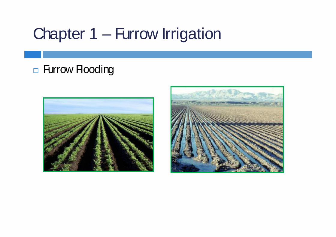
Chapter 1 – Furrow Irrigation
Furrow Flooding

Chapter 1 – Furrow Irrigation
Furrow Flooding

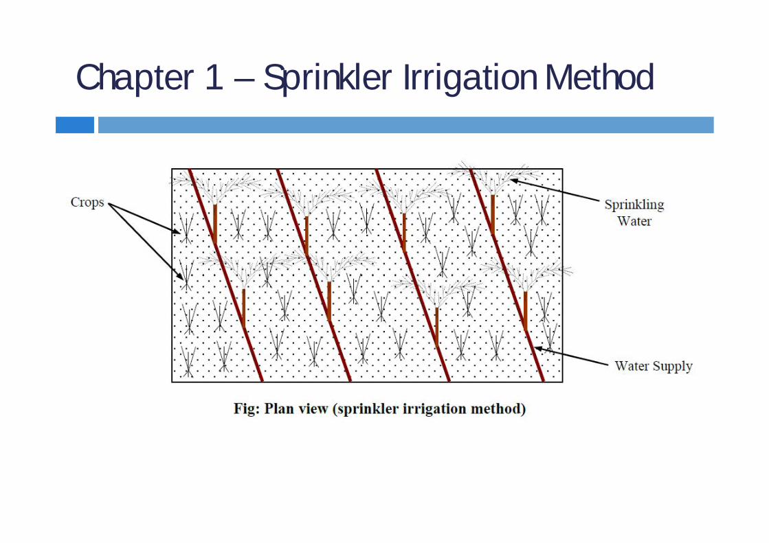
Chapter 1 – Sprinkler Irrigation Method
Sprinkler Irrigation Water is applied to the soil in the form of a spray through
a network of pipes and pumps It is kind of an artificial rain and gives good results It is a costly process and not widely used in our country It can be used for all types of soils and for widely different
topographies and slopes It fulfils the normal requirement of uniform distribution of
water Although highest amount of water surrounding the pipe, but
due to overlapping of the irrigated area, uniform distribution of water is possible
Chapter 1 – Sprinkler Irrigation Method

Chapter 1 – Sprinkler Irrigation Method
Types of Sprinkler SystemsPermanent system: In permanent system, pipes are
permanently buried in such a way that they do not interfere with the farming operations
Semi-permanent system: In semi-permanent system, the main lines are buried in the ground, while the laterals are portable
Portable system: In the portable system, the mains as well as laterals are portable. These portable networks can be moved from farm to farm

Chapter 1 – Sprinkler Irrigation Method
Sprinkler Irrigation Method

Chapter 1 – Methods of Irrigation
Sprinkler Irrigation Method

Chapter 1 – Sprinkler Irrigation Method
Adaptability This method can be used for almost all crops (except rice and
jute) and on most soils It is best suited to sandy soils that have a high infiltration rate It can be applied to any topographic conditions without
extensive land preparation
Advantages Seepage losses which occur in earthern cannels of surface
irrigation methods are completely eliminated. Moreover, only optimum quantity of water is used in this method

Chapter 1 – Sprinkler Irrigation Method
Land leveling is not required and thus avoiding removal of top fertile soil, as happens in other surface irrigation methods
No cultivation area is lost for making ditches results in increasing about 16% of the cropped area
water can be applied at a rate lesser than the infiltration capacity of soil and thus avoiding surface run off
This method leaches down salts and prevents water-logging or salinity
It is less labor oriented and hence useful where labor is costly and scarce
Small and frequet application of water can be applied readily

Chapter 1 – Sprinkler Irrigation Method
Up to 80% of applied water can be stored in the root zone of plants
Fertilizers can be uniformly applied, because they can mixed with irrigation water
Limitations High winds may distort sprinkler pattern, causing non-uniform
spreading of water on the crops In areas of high temperature and high wind velocity,
considerable evaporation losses of water may take place They are not suited to crops requiring frequent and larger
depths of irrigation, such as rice production

Chapter 1 – Sprinkler Irrigation Method
Initial cost of the system is very high (due to cost of pipe, nozzle, pump), and the system requires a high technical skill
A constant water supply is needed for commercial use of equipment
Only sand and silt free water can be used, as otherwise pump impellers lifting such water will get damaged

Chapter 1 – Sprinkler Irrigation Method
Advantages, Limitation, Conditions for adaptation: Book Garg
Discuss the feasibility or adaptability for suitability of Sprinkler system in context of BangladeshNot Suitable because (a) High initial cost, (b) High operating cost, (c) Rice is main crop in our country, for which sprinkler system
is not suitable, (d) For our country, we need labour intensive method rather
than mechanized method

Chapter 1 – Drip Irrigation Method
Drip Irrigation It is the latest field irrigation technique (also called trickle
irrigation) Irrigation water is applied by using small diameter (12 to 32
mm) plastic lateral lines The lateral lines contains some devices called ‘emitters’ at
selected spacing to deliver water to the soil surface near the base of the plants
It is best suited for widely spaced plants, salt problems and for areas with water scarcity
Water is applied where root of plant remains and water is applied at a very low rate (drop by drop)

Chapter 1 – Drip Irrigation Method
In this method, water is slowly and directly applied to the root zone of the plants for minimizing the losses by evaporation and percolation
This method is being used for small nourishes, orchards or gardens (suitable for widely spaced and small plants)

Chapter 1 – Drip Irrigation Method
Chapter 1 – Drip Irrigation Method
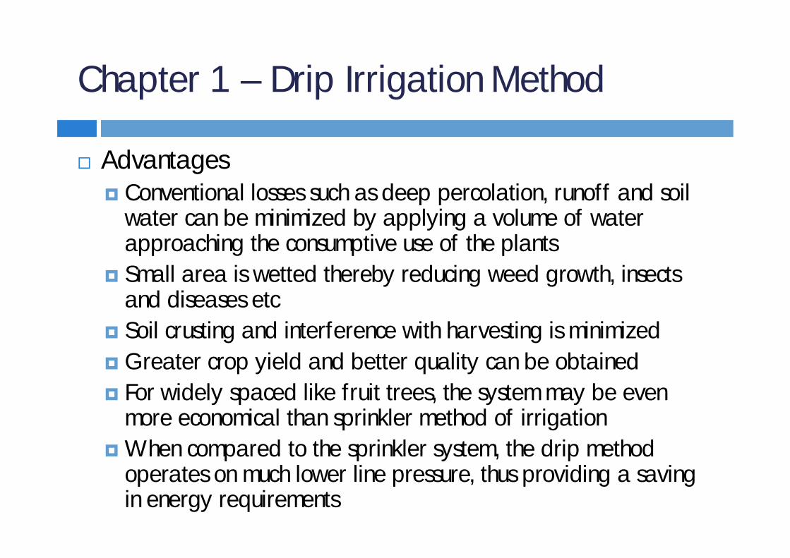
Advantages Conventional losses such as deep percolation, runoff and soil
water can be minimized by applying a volume of water approaching the consumptive use of the plants
Small area is wetted thereby reducing weed growth, insects and diseases etc
Soil crusting and interference with harvesting is minimized Greater crop yield and better quality can be obtained For widely spaced like fruit trees, the system may be even
more economical than sprinkler method of irrigation When compared to the sprinkler system, the drip method
operates on much lower line pressure, thus providing a saving in energy requirements

Chapter 1 – Drip Irrigation Method
Disadvantages High initial cost of the drip irrigation equipment sometimes
limits its use to orchard and vegetables in water scarcity areas Clogging of emitter may disrupt the irrigation system Plastic pipes may damage by rodents Wind erosion can harm the pipes Like the sprinkler method, drip irrigation permits the
simultaneous application of fertilizers through the system

Chapter 1 – Irrigation Engineer
Job description of an irrigation engineerComputation of water requiredDetermination of water resourcesCollection, storage and diversion of waterConveyance / transportDistributionDrainage of excess waterProtection against flood

Chapter 1 – Irrigation Project Survey
Availability of Irrigation WaterSelection of probable site for Barrage or DamDischarge observation of the riverMarking of GCA and Cultivable areaMarking alignment of main canalPreliminary location survey Final Survey: Final location of Barriage or Dam, Route
survey, Longitudinal levelling, Cross-sectional levelling, Data for cross-drainage works, soil survey and well observation

Chapter 1 – Irrigation Project Survey
Preparation of drawingsOffice works Justification of the selection of final alignment Final location survey

Chapter 1 – Irrigation Project Survey
Availability of Irrigation Water: When it is found necessary to take up an irrigation project, the availability of required water should be investigated. The following points should be considered:Whether any perennial river is available near the command
area or not If a river is available, the maximum discharge of that river is to
be ascertained from the highest flood level mark (can be discussed with the villagers residing near the river bank)
From various investigation (i.e. maximum discharge, rainfall etc) it is necessary to estimate whether the river will be able to meet the total water requirement or not

Chapter 1 – Irrigation Project Survey
Selection of probable site for Barrage or Dam: When the source of water is available, the suitable site for the barrage or dam should be found out considering the following points: The course of the river should be straight at least for a distance
of about a km both on the u/s and d/s side of the site A suitable basin should be available for the storage reservoir Elevation of the site should be higher than that of the culturable
command area Storage reservoir should not submerge much valuable land Capacity of the reservoir should fulfill total water requirement

Chapter 1 – Irrigation Project Survey
Discharge observation for the river: Appropriate gauge and discharge observation station should be established at the proposed site to collect the following data: Daily discharge, max discharge and min discharge of the river
throughout the year should be recorded Silt analysis should be carried out in rainy season (when the river
carries much silt) to determine the nature of sedimentation in river or reservoir
Discharge observations should also be carried out for all the rivers crossing the proposed canal. This is required for designing cross-drainage works

Chapter 1 – Irrigation Project Survey
Marking of GCA and Cultivable area: When it is decided to make up the project, the gross command area should be marked on the topographic map. Culturable areas should be defined on the map to find culturable command area that is to be included in the project

Chapter 1 – Irrigation Project Survey
Marking of alignment of main canal: Alignment should be marked on the topographical map of the concerned area. While marking the alignment following points should be kept in mind: Alignment of the main canal should be taken in such a way that
unnecessary cutting and banking is avoided Alignment should be such that the branch canals can be taken
suitably to cover the whole culturable area Alignment shuould cross the rivers, roads, railway lines etc
perpendicularly as much as possible Alignment should not be taken through the valuable agricultural
land Alignment should not pass through the thickly populated areas,
religious places, burial grounds etc

Chapter 1 – Irrigation Project Survey
Preliminary location survey: Reconnaissance survey should be carried out along the alignment to record necessary data such as obstacles, road crossings, railway crossings, river crossings etc. This survey involves the following porcedures: Approx distance along the alignment should be measured and
noted in the field bookObjects and nature of the gound on both sides of the alignment
should also be noted Alignement may be diverted to avoid religious places, valuable
structures etc An index should be prepared for the alignment

Chapter 1 – Irrigation Project Survey
Final survey:(a) Final location of Barrage or Dam: this should consider the
following steps Centre line of the barrage or dam site should be marked with
pillars on both banks of the river Cross-section of the barrage site should be taken precisely Cross-sections should be taken at regular interval on the u/s side
of the barrage site to check storage capacity of reservoir Boring test should be carried out along the centre line of the
barrage site to determine the depth and nature of foundation

Chapter 1 – Irrigation Project Survey
Final survey:(b) Route Survey: A prismatic compass survey or plane table
survey should be conducted along the alignment of the main canal to prepare a route survey map of the area covering a distance of about 30 m on both sides of the alignment
(c) Longitudinal Leveling: Longitudinal leveling should be done along the alignment of the main canal. Generally, staff readings are taken at an interval of 20 m along the centre line of the main canal. Longitudinal leveling for the branch canals should also be done

Chapter 1 – Irrigation Project Survey
Final survey:(d) Cross-sectinal leveling: Cross-sectional leveling at regular
intervals along the alignment of the main canal should be taken. Cross-sections for the branch canals also should be taken. Cross-sections are required to compute volume of earth work
(e) Data for cross drainage works: At the place of river crossings, road crossings, railway crossings, additional data should be collected for designing cross-drainage works. At the sites of the river crossings, the gauge and discharge observation stations should be established

Chapter 1 – Irrigation Project Survey
Final survey:(f) Soil survey: Soil survey should be conducted along the
alignment. It consists of collecting the sample of soil by boring up to the depth until impervious layer is obtained
(g) Well observation: Well observation should be carried out along the alignment. This operation consists of measuring the water level of the wells existing on both sides (within 50 m) of the alignment. This is done to know the nature of water table along the course of the canal

Chapter 1 – Irrigation Project Survey
Preparation of drawings: Route survey map (in a suitable scale) Longitudinal sections for the main and branch canals with
formation level (in a suitable scale) Cross-sections of main and branch canals with formation level (in
a suitable scale) Contour map along the alignment Location of curves

Chapter 1 – Irrigation Project Survey
Office works: Sections of the canals should be designed Detailed estimate should be prepared to know the volume of earh
work in cutting or banking along the main canal and branch canals Total land width required should be marked on the route survey
map Design of the barrage or dam, cross-drainage works and other
allied structures should be completed Detailed report should be prepared for the compensation. It
includes the names of owners, location, amount of properties, valuation of the land etc
Total cost of the project should be estimated considering all the aspects

Chapter 1 – Irrigation Project Survey
Justification of the selection of final alignment: After preliminary survey, estimates for the tentative alignments (if taken) are prepared. Then by comparing the total costs, working feasibility etc with the alignments the final alignment is selected
Final location survey: Final location survey of the approved alignment of the canal should be carried out for the execution of the project works which includes the followings: Centre line of the main and branch canals should be marked with
concrete pillars at intervals of 30m to 50m Total land width required for the main and branch canals should
be marked with pillars at suitable intervals

Chapter 1 – Irrigation Project Report
Intorduction: Aim of the project, location, area, population to be benefited, cost of the project etc
Necessity and economic justification Report on land acquisitin and composation Details of design and drawing of hydraulic structures Detailed estimate Specification Availability of materials and labors Communication Maps Conclusion and recommendaton

Chapter 1 – Irrigation Project Report
Intorduction: need to consider the following itemsAim of the project Location of the project Total area to be covered within the project Total population to be benefited by the project Future prospect if irrigation is practicedStages of future development Total cost of the project

Chapter 1 – Irrigation Project Report
Necessity and economic justification: need to illustrate the following points clearly Amount of yearly rainfallNature of distribution of rainfall during the crop season Types of major crops grown in the area Total water requirement of the crops Amount of water requirement by irrigation system Expected increase in yield of crops if irrigation is practiced Total revenue expected

Chapter 1 – Irrigation Project Report
Report on land acquisition and compensation: A detailed statement should be prepared showing the names of owners, types of properties, quantity, amount of compensation etc. The procudure adopted for the land acquisition should be clearly mentioned
Details of design and drawing of hydraulic structures: Detailed design procedure and drawing of hydraulic structures, canals and other allied structures should be incorporated
Detailed estimate: Detailed estimate for all the works of the project should be incorporated

Chapter 1 – Irrigation Project Report
Specification: Specifications of the construction materials and different works should be clearly mentioned
Availability of materials and laborers: Source of construction materials and places of recruitment of laborers should be mentioned
Communication: Existing communication to the selected barrage or dam site should be pointed out. If new communication is required for inaccessible site, the possible route should be pointed out and the expenditure for the new route should be included in the project

Chapter 1 – Irrigation Project Report
Maps: Topographical map of the area showing the canal alignment and
barrage or dam site Route survey map Longitudinal sections Cross-sections Contour map of alignment Detailed drawing of barrage or dam, cross-drainage works etc
Conclusion and recommendation: After furnishing all the aspects of the projects, the proposal is forwarded to the higher authority with proper recommendation for the necessary approval