Embed Size (px)
Citation preview

Conservation Security Program
Irrigation Water Management
Irrigation System Screening Worksheet
Name: Farm/Ranch:
Name: Farm/Ranch:
Conservation Security Program
Washington

2
Washington Natural Resources Conservation Service

3
Washington Natural Resources Conservation Service
Irrigation System Screening Worksheet
This eligibility tool is designed to help irrigated producers conduct a self assessment for their eligibility in the Conservation Security Program. CSP is a voluntary program that provides fi nancial and technical assistance to promote the conservation and improvement of soil, water, air, energy and animal life on Tribal and private working lands. This procedure will result in assigning an Irrigation System Value to the irrigation system being evaluated.
The way that this value works is that it starts with a base value that is as-signed to the specifi c type of irrigation system in use. Then modifi ers are applied based on the level of management and the effi ciency of the delivery system. A bonus is given if runoff from the irrigated fi eld is captured for reuse.
When this self assessment is complete, the landowner will have calculated an Irrigation System Value for the irrigation system being evaluated. The Irrigation System Value is not an effi ciency number, but an indicator or evaluation of how well the system is doing. If the Irrigation System Value is over 50, the landowner may be eligible for the CSP. This self assessment is simple and should take less than 5 minutes to complete. A basic hand calculator is needed to complete the Irrigation System Screening Tool Worksheet. In addition, basic knowledge of the irrigation system and management practices is necessary. Defi nitions of the various terms areincluded in this tool.
The payment levels for Irrigation Enhancement have been determined for each individual watershed in the CSP Program. The level of payment is based on the importance of enhanced irrigation to the quality and quantity of water in that watershed.
Irrigation System Screening ToolIrrigation System Screening Tool

4
Washington Natural Resources Conservation Service
Irrigation System Screening Worksheet
Example in Italics Example Values Your System Values
System TypeSystem Type – From Table 1.
Graded Furrow75
Measurement Method – From Table 2.
Whole Farm- manually recorded0.93
Scheduling MethodScheduling Method – From Table 3.
Soil Moisture by NRCS feel method0.93
Water Control – From Table 4.
Flow rates are adequately controlled.0.98
Water ConveyanceWater Conveyance- From Table 5.
Open Canal – Lined0.98
Land SlopeLand Slope – From Table 6.
Land Leveled0.94
Tailwater Capture and ReuseTailwater Capture and Reuse – From Table 7.
Tailwater not Captured1.00
Irrigation System Value Irrigation System Value
75 X 0.93 X 0.93 X 0.98 X 0.98 X 0.94 X 1.0 = 58.6
58.6
Directions:
1. Use tables on the following page to determine your irrigation system values. Place these values in the column titled “Your System”.
2. Calculate Your Irrigation System Value by MULTIPLYING each of the values found for your irrigation system.
3. If the resulting Irrigation System Value is 50 or greater you may be eligible for the CSP program. Contact you local NRCS Field Offi ce for further eligibility screening.
4. If your Irrigation System Value is less than 50 you are not eligible for participation in the CSP Program. Consider utilizing other USDA programs to improve your irrigation system.
Irrigation System Screening WoeksheetIrrigation System Screening Woeksheet

5
Washington Natural Resources Conservation Service
Table 1. Irrigation System Type Border Irrigation ValueGraded Border 80Level or Basin 90Contour Level Field Crop 70Border Ditch 60
Furrow Irrigation ValueLevel or Basin 90Graded Furrow 75Contour Furrow 75Corrugations 75Surge 80
Flood Irrigation ValueControlled 60Uncontrolled 50Contour Ditch 60
Sprinkler Irrigation ValueBig Gun or Boom 60Hand Line or Wheel Line 70Solid Set (above canopy) 75Solid Set (below canopy) 80
Center Pivot Irrigation Value Generic 80Low Pressure Improved 83LEPA 92LESA 89LPIC 87MESA 85Variable Rate Irrigation (VRI) 87
Lateral Move Irrigation ValueGeneric 82LEPA, LESA, LPIC, MESA 87
Micro Irrigation ValuePoint Source 90Sprays 85Continuous Tape 90Subsurface Drip irrigation 92
Sub-Irrigation ValueSubirrigated 75
Irrigation System Screening Tables
Irrigation System Screening TablesIrrigation System Screening Tables

6
Washington Natural Resources Conservation Service
Irrigation System Screening TablesTable 2. Method of Measuring Flow Value
No Flow Measuring device 0.90Whole farm-manually recorded 0.93Whole farm-automatic recorded 0.95Whole farm plus individual fi eld manual 0.97Whole farm plus individual fi eld automatic recorded 1.00
Table 3. Method of Scheduling Irrigation Value
Visual crop stress 0.90Soil moisture by NRCS feel method 0.93Check book scheduling, irrigation scheduler, etc 0.96Irrigation scheduling via pan evaporation or atmometer for fi eld 0.97Irrigation scheduling via regional weather network 0.98Soil moisture using Gypsum blocks, moisture probe, etc 0.99Continuous measurement of soil moisture, water applied and ET 1.00
Table 4. Ability to Control Water Distribution Value
Very poor diversion facilities. Little control of fl ow rate to farm 0.90Can control fl ow rates to farm, but the on-farm delivery system operation is very hard to deliver the desired fl ow to any given fi eld. 0.94
Flow rates to each fi eld are adequately controlled. Flow rates to each set are diffi cult to control 0.98
All fl ow rates to each set are adequately controlled 1.00
Table 5. Water Conveyance Value
Open ditch or canal - sand/gravel 0.90Open ditch or canal - sandy loam 0.93Open ditch or canal - clay soil 0.96Open canal – lined 0.98Closed conduit pipeline 1.00
Table 6. Precision of Land Slope Value
Land smoothed 0.90Land leveled 0.94Land precision leveled 0.98Land precision leveled - slope <= .005 1.00A sprinkler system is utilized 1.00
Table 7. Tailwater Captured and Reused Value
No Tailwater or Tailwater not captured 1.00Irrigation System Type less than or equal to 60 1.25Irrigation System Type between 61 and 80 1.15Irrigation System Type greater than 80Irrigation System Type greater than 80 1.10
Irrigation System Screening TablesIrrigation System Screening Tables
7
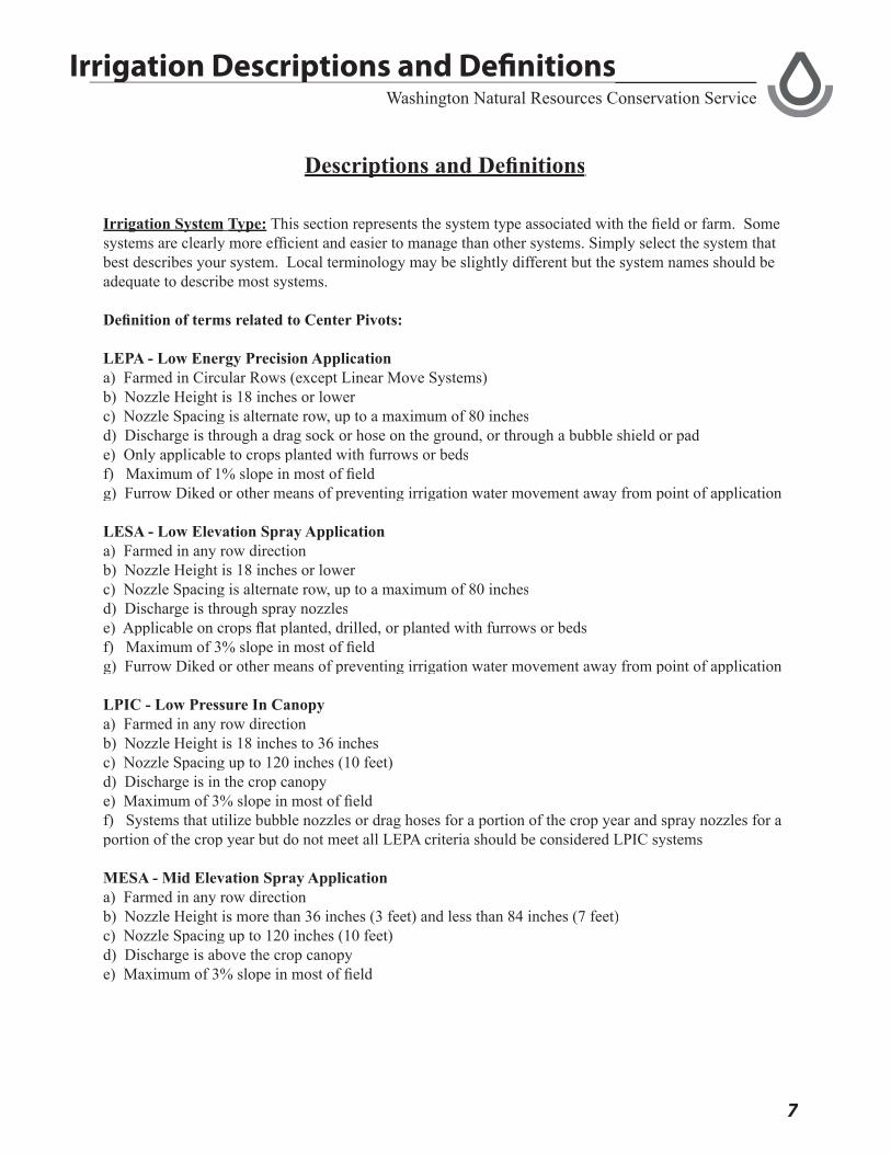
Washington Natural Resources Conservation ServiceIrrigation Descriptions and Defi nitionsIrrigation Descriptions and Defi nitions
Descriptions and Defi nitionsDescriptions and Defi nitions
Irrigation SystemIrrigation System Type:Type: This section represents the system type associated with the fi eld or farm. Some systems are clearly more effi cient and easier to manage than other systems. Simply select the system that best describes your system. Local terminology may be slightly different but the system names should be adequate to describe most systems.
Defi nition of terms related to Center Pivots:
LEPA - Low Energy Precision Application a) Farmed in Circular Rows (except Linear Move Systems)b) Nozzle Height is 18 inches or lowerc) Nozzle Spacing is alternate row, up to a maximum of 80 inchesd) Discharge is through a drag sock or hose on the ground, or through a bubble shield or pade) Only applicable to crops planted with furrows or bedsf) Maximum of 1% slope in most of fi eldg) Furrow Diked or other means of preventing irrigation water movement away from point of application
LESA - Low Elevation Spray Applicationa) Farmed in any row directionb) Nozzle Height is 18 inches or lowerc) Nozzle Spacing is alternate row, up to a maximum of 80 inchesd) Discharge is through spray nozzlese) Applicable on crops fl at planted, drilled, or planted with furrows or bedsf) Maximum of 3% slope in most of fi eldg) Furrow Diked or other means of preventing irrigation water movement away from point of application
LPIC - Low Pressure In Canopya) Farmed in any row directionb) Nozzle Height is 18 inches to 36 inchesc) Nozzle Spacing up to 120 inches (10 feet)d) Discharge is in the crop canopy e) Maximum of 3% slope in most of fi eldf) Systems that utilize bubble nozzles or drag hoses for a portion of the crop year and spray nozzles for a portion of the crop year but do not meet all LEPA criteria should be considered LPIC systems
MESA - Mid Elevation Spray Applicationa) Farmed in any row directionb) Nozzle Height is more than 36 inches (3 feet) and less than 84 inches (7 feet)c) Nozzle Spacing up to 120 inches (10 feet)d) Discharge is above the crop canopy e) Maximum of 3% slope in most of fi eld

8
Washington Natural Resources Conservation ServiceIrrigation Descriptions and Defi nitionsIrrigation Descriptions and Defi nitions
Variable-Rate Irrigation (VRIVariable-Rate Irrigation (VRI)), also called site-specifi c irrigation or precision irrigation, is a relatively new concept in agriculture. Variable-rate irrigation is a tool of Precision Farming that involves the delivery of irrigation water in optimum amounts over an entire fi eld.
Method of Measuring Flow:Method of Measuring Flow: Water measurement is a critical component of any well planned and managed irrigation system. Knowing how much water is delivered to a farm, fi eld, or irrigation set is critical to making effi cient use of water.
• No fl ow measuring devices - No fl ow measuring devices are present. The applicant has no way of measuring and recording the amount of water delivered to the farm, to the fi elds, or to the irrigation set.
• Flow measurement - whole farm, manually recorded - The applicant has a measuring device (calibrated fl ume or fl ow meter) that can be used to measure the amount of water that is delivered to the farm. It may be a fl ow meter on a well that serves one fi eld or a calibrated fl ume that measures water delivered through a distribution system to the farm. The measurement system does not automatically record the measurement. The applicant must inspect the measurement device and manually record the results in a routine manner and the results used in irrigation planning and scheduling.
• Flow measurement - whole farm, automatic recorded - Flow measurement are taken utilizing the process described immediately above but the measurements are automatically recorded and are used in planning and scheduling irrigations.
• Flow measurement - whole farm plus individual fi eld, manual - The applicant has the ability to measure water that comes to the whole farm as well as to each individual fi eld. The fl ow measurements are obtained utilizing a measuring device such as a fl ow meter. In this instance the applicant can measure the water fl owing to the farm and to each fi eld. He routinely checks and records the data manually and uses the results to plan and schedule irrigations.
• Flow measurement - whole farm plus individual fi eld, automatic recorded - The applicant has the ability to measure water fl owing to the farm and to each fi eld using fl ow meters or fl umes. The results are automatically recorded using a recording device and used for planning and scheduling irrigations.
Method of Scheduling IrrigationMethod of Scheduling Irrigation
• Visual crop stress - Water management decisions are made from visual indicators related to crop growth. In some instances the crops may be stressed before decisions are made to add needed water.
• Soil moisture by NRCS feel method - Soil moisture is used as the factor to determine when water is to be added using the NRCS feel method. The manager has received some training and has a publication that describes the NRCS feel method.
9
Washington Natural Resources Conservation Service
• Check book scheduling, irrigation scheduler, etc. - A check book method is used to track and schedule irrigations. Training and fact sheets are available from land grant universities and the results are commonly utilized to manage timing and application of irrigation water.
• Irrigation scheduling via pan evaporation or atmometer for fi eld - Other slightly more sophisticated systems provide reliable methods for scheduling irrigation water applications. Pan evaporation and atmometers are listed here but other devices may be available.
• Irrigation scheduling via regional weather network - An irrigation scheduling system or Irrigation scheduling via regional weather network - An irrigation scheduling system or Irrigation scheduling via regional weather networknetwork that includes weather stations that track climatic conditions and predict irrigation water needs is utilized. These may include on site weather stations or regional weather stations that are operated by commercial or public entities. These networks may be on-line or a group of operators within the watershed area that are moving toward precision water application.
• Soil moisture using gypsum blocks, moisture probe, etc. - Methods to track soil moisture including gypsum block, tensiometers, soil moisture probes and other similar tools are used. With calibration these methods become very accurate.
• Continuous measurement of soil moisture, water applied and ET - This combines all methods soil Climate and Checkbook to perform Precision application
Ability to Control Water Distribution:Ability to Control Water Distribution: This management enhancement recognizes the ability of the irrigator to manage, direct and control the water fl ow stream on to the farm, across the farm to one or more fi elds, and to multiple irrigation sets that may be on the farm or fi eld. The better the control, the higher the irrigation enhancement. Most pumped and piped distribution systems provide adequate control to each set.
• Very poor diversion facilities, little control of fl ow rate to farm • Can control fl ow rates to farm, but the on farm delivery system is such that it is very hard to
deliver the desired fl ow to any given fi eld• Flow rates to each fi eld are adequately controlled. Flow rates to each set are diffi cult to control• All fl ow rates to each set are adequately controlled – Should be selected for Center Pivots and
other pumped and piped distribution systems
Water Conveyance:Water Conveyance: Water movement across the farm is a critical component. Losses occur from evaporation and deep percolation within the ditch. Sandy soils have more potential for water losses than clay soils. Lined ditches and canals have evaporation losses but limited deep percolation losses. Closed conduits are the most effi cient water delivery systems.
• Open ditch or canal, sand/gravel - Ditches and canals may involve a combination of soils with part of the conveyance in sandy soils and part in clay soils. Select the factor that is predominant
• Open ditch or canal, sandy loam - Ditches and canals may involve a combination of soils with part of the conveyance in sandy soils and part in clay soils. Select the factor that is predominant
Irrigation Descriptions and Defi nitionsIrrigation Descriptions and Defi nitions

10
Washington Natural Resources Conservation Service
• Open ditch or canal, clay soil - Ditches and canals may involve a combination of soils with part of the conveyance in sandy soils and part in clay soils. Select the factor that is predominant
• Open canal, lined – Concrete, plastic, or other impervious materials
• Closed conduit pipeline – Plastic, concrete, or other pipeline materials
Precision of Land Slope:Precision of Land Slope: Precision leveled fi elds have higher effi ciency potential and are easier to manage that less controlled grades and slopes. This enhancement category recognizes this factor.
• Land smoothed - This factor represents land that has been smoothed. Highs and lows have been manipulated to provide a more uniform fl ow of water but not to the precision listed below. This is the value that should be selected if any of the factors below do not apply.
• Land leveled - Land that has been leveled but conventional survey and construction equipment has been utilized.
• Land precision leveled - This factor represents land that has been precision leveled utilizing laser controlled equipment with high quality control. The grade will be more than 1/2%.
• Land precision leveled, slope <= .005 - This factor represents precision leveled land that is 1/2 % grade or less.
Irrigation Descriptions and Defi nitionsIrrigation Descriptions and Defi nitions

11
Washington Natural Resources Conservation Service
USDA Nondiscrimination Statement“The U.S. Department of Agriculture (USDA) prohibits discrimination in all its programs and activities on the basis of race, color, national origin, sex, religion, age, disability, political beliefs, sexual orientation, and marital or family
status. (Not all prohibited bases apply to all programs.) Persons with disabilities who require alternative means for communication of program information (Braille, large print, audiotape, etc.) should contact USDA’s TARGET Center at (202) 720-2600 (voice and TDD). To fi le a complaint of discrimination, write USDA, Director, Offi ce of
Civil Rights, Room 326-W, Whitten Building, 14th and Independence Avenue, SW, Washington, DC 20250-9410, or call (202) 720-5964 (voice or TDD). USDA is an equal opportunity provider and employer.”
Notes