Embed Size (px)
Citation preview
1
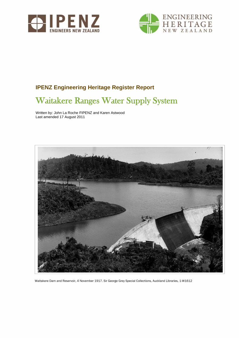
Waitakere Dam and Reservoir, 4 November 1917. Sir George Grey Special Collections, Auckland Libraries, 1-W1612
IPENZ Engineering Heritage Register Report
Waitakere Ranges Water Supply System Written by: John La Roche FIPENZ and Karen Astwood Last amended 17 August 2011
IPENZ Engineering Heritage Report 2
Waitakere Ranges Water Supply System
Contents
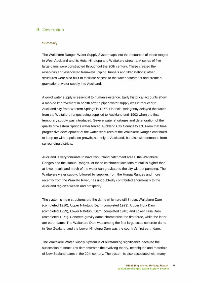
A. General information ........................................................................................................... 3
B. Description ......................................................................................................................... 5
Summary ................................................................................................................................. 5
Historical narrative .................................................................................................................... 7
Social narrative ...................................................................................................................... 20
Physical narrative ................................................................................................................... 23
C. Assessment of significance ............................................................................................. 28
D. Supporting information ...................................................................................................... 29
List of supporting documents ................................................................................................... 29
Bibliography ........................................................................................................................... 29
IPENZ Engineering Heritage Report 3
Waitakere Ranges Water Supply System
A. General information
Name: Waitakere Ranges Water Supply System
Alternative names: Auckland Water Supply System; Auxiliary Nihotupu Dam; Lower
Huia Dam and Reservoir; Lower Nihotupu Dam and Reservoir; Main Nihotupu Dam;
Upper Huia Dam and Reservoir; Upper Nihotupu Dam and Reservoir; Waitakere Dam
and Reservoir; Waitakere Ranges Water Supply Dams; Waitakere Ranges Regional
Park Water Catchment
Location:
Waitakere Regional Park
Waitakere Ranges
Auckland
Geo-reference:
Lower Huia Dam and Reservoir - Latitude: -36.989, Longitude: 174.567
Lower Nihotupu Dam and Reservoir - Latitude: -36.962, Longitude: 174.614
Upper Huia Dam and Reservoir - Latitude: -36.964, Longitude: 174.538
Upper Nihotupu Auxiliary Dam (former) - Latitude: -36.933, Longitude: 174.556
Upper Nihotupu Dam and Reservoir - Latitude: -36.951, Longitude: 174.563
Waitakere Dam and Reservoir - Latitude: -36.899, Longitude: 174.529
Legal description:
Lower Huia Dam and Reservoir: Part of Pt Lot 9 PSH and Lot 14 PSH, Karangahape,
North Auckland Land District
Lower Nihotupu Dam and Reservoir: Pt Lot 33 PSH, Waikomiti; Pt Lt 2 DP 19340 (CT
NA10B/611), North Auckland Land District
Upper Huia Dam and Reservoir: Pt Lot 112 PSH, Karangahape (CT NA12D/361),
North Auckland Land District
Upper Nihotupu Dam and Reservoir: Part of Lot 112 PSH, Karangahape (CT
NA12D/361); Lot 95 PSH, Waikomiti (CT NA10D/397), North Auckland Land District
Waitakere Dam and Reservoir: Part of Pt Lot N82 PSH, Waitakere; Lot S50 PSH,
Waitakere, North Auckland Land District
Access information:
All of the Waitakere Ranges water supply dams and reservoirs are within the
Waitakere Regional Park. They can be viewed by following access roads or walking
IPENZ Engineering Heritage Report 4
Waitakere Ranges Water Supply System
tracks. This is a working system and as such there are access restrictions to the
structures. Restricted areas are fenced and/or signposted.
City/District Council: Auckland Council
IPENZ category: Engineering work
IPENZ subcategory: Infrastructure
IPENZ Engineering Heritage number: 2385
Associated IPENZ Engineering Heritage numbers: Lower Nihotupu Dam (EH
no.87); Upper Nihotupu Dam (EH no.288)
Date registered: 18 October 2011
Other IPENZ recognition: “Engineering to 1990” plaque, Lower Nihotupu Dam
Other heritage recognition:
New Zealand Historic Places Trust: N/A
Associated Local Authority District Plan heritage listings:
Huia Filter Station – Waitakere District Plan, Heritage Appendix, p.5, CHI no.
1257
Nihotupu Filter Station – Waitakere District Plan, Heritage Appendix, p.6, CHI
no. 1283
Waitakere Filter Station – Waitakere District Plan, Heritage Appendix, p.6,
CHI no. 1289
Other: Waitakere Ranges Heritage Area Act 2008
IPENZ Engineering Heritage Report 5
Waitakere Ranges Water Supply System
B. Description
Summary
The Waitakere Ranges Water Supply System taps into the resources of these ranges
in West Auckland and its Huia, Nihotupu and Waitakere streams. A series of five
large dams were constructed throughout the 20th century. These created the
reservoirs and associated tramways, piping, tunnels and filter stations; other
structures were also built to facilitate access to the water catchment and create a
gravitational water supply into Auckland.
A good water supply is essential to human existence. Early historical accounts show
a marked improvement in health after a piped water supply was introduced to
Auckland city from Western Springs in 1877. Financial stringency delayed the water
from the Waitakere ranges being supplied to Auckland until 1902 when the first
temporary supply was introduced. Severe water shortages and deterioration of the
quality of Western Springs water forced Auckland City Council to act. From that time,
progressive development of the water resources of the Waitakere Ranges continued
to keep up with population growth, not only of Auckland, but also with demands from
surrounding districts.
Auckland is very fortunate to have two upland catchment areas, the Waitakere
Ranges and the Hunua Ranges. At these catchment locations rainfall is higher than
at lower levels and much of the water can gravitate to the city without pumping. The
Waitakere water supply, followed by supplies from the Hunua Ranges and more
recently from the Waikato River, has undoubtedly contributed enormously to the
Auckland region‟s wealth and prosperity.
The system‟s main structures are the dams which are still in use: Waitakere Dam
(completed 1910), Upper Nihotupu Dam (completed 1923), Upper Huia Dam
(completed 1929), Lower Nihotupu Dam (completed 1948) and Lower Huia Dam
(completed 1971). Concrete gravity dams characterise the first three, while the latter
are earth dams. The Waitakere Dam was among the first large scale concrete dams
in New Zealand, and the Lower Nihotupu Dam was the country‟s first earth dam.
The Waitakere Water Supply System is of outstanding significance because the
succession of structures demonstrates the evolving theory, techniques and materials
of New Zealand dams in the 20th century. The system is also associated with many

IPENZ Engineering Heritage Report 6
Waitakere Ranges Water Supply System
of Auckland‟s notable engineers, including Hugh Munro Wilson (1865-1929), James
Carlaw, Walter Ernest Bush (1875-1950), Arthur D Mead (d.1976), Cyril Firth (1903-
2003), Don Wilson and others.
IPENZ Engineering Heritage Report 7
Waitakere Ranges Water Supply System
Historical narrative
The Waitakere Ranges, west of Auckland city, have long been known for their water
resources. Numerous streams not only provided early local Māori with drinking water,
but also a plentiful supply of koura and eels. Later, these same waterways were
dammed and utilised by early European settlers involved in milling and mining
activities.1
In 1840 Governor William Hobson (1792-1842) founded Auckland, the new capital of
the New Zealand colony. During the first few decades citizens depended on stored
rain water, springs, and public and private wells for their water. Even in this early
Colonial period demand was such that queues would form at the central public wells
before daybreak. This situation remained largely unchanged until the 1870s.2 At this
time Edward Orpen Moriarty (1824-1896) investigated several water supply options,
which included the Nihotupu Stream. However, Western Springs was chosen as the
site from which to pump water. Mr Moriarty anticipated this supply would be sufficient
for up to 25 years, and he was proven correct.3
At the turn of the 20th century Auckland was already the leading industrial province in
New Zealand and attracted people due to its “delightful climate and other
advantages.”4 As such, it was apparent Auckland‟s water supply issue needed to be
addressed. Indeed, in a report on the situation in 1900, engineer Richard Liron
Mestayer (1844-1921) stated that “the position of Auckland in respect to its water
supply is critical in the extreme […] in fact, on the verge of water famine.”5 Later that
year, Henry Atkinson proposed building a temporary solution in the form of a timber
dam across the Upper Nihotupu Stream.6 Mr Mestayer envisaged the first stage of a
system, later involving the Nihotupu and Huia streams, would involve damming the
Waitakere River, an approach which the Auckland City Council adopted. The idea of
the timber dam was supported by consulting engineer, Hugh Munro Wilson (1865-
1929), a New Zealand-born engineer who went on to design the Waitakere Dam.7
1 F. MacDonald & R. Kerr (ed.), West: The history of Waitakere, Auckland, 2009, p.309; J. Reidy, „Waitakere Water:
A city‟s need for water,‟ in B. & T. Harvey (ed.), Waitakere Ranges: Ranges of inspiration, Auckland, 2006, p.312
2 J. Barr, Municipal and Official Handbook of the City of Auckland, New Zealand, Auckland, 1922, p.121
3 Ibid., p.122; F. W. Furkert, Early New Zealand Engineers, Wellington, 1953, p.230
4 The Cyclopedia Company Limited, Cyclopedia of New Zealand [Auckland Provincial District], Christchurch, 1902,
p.29
5 Quoted in R. E. Offer, Walls for Water: Pioneer dam building in New Zealand, Dunmore Press, Palmerston North,
1997, p.38
6 „Auxiliary Water Supply,‟ Auckland Star, 30 October 1901, p.2
7 Progress, 1 May 1909, p.251; Offer, p.38
IPENZ Engineering Heritage Report 8
Waitakere Ranges Water Supply System
A few years later Mr Wilson, and James Carlaw, Auckland‟s Waterworks Engineer,
were asked to report on how best to develop a “permanent” water supply for
Auckland, drawing on the Waitakere Ranges catchment. They recommended building
a concrete gravity dam at the Waitakere Falls.8 This 1902 report was one of a long
history of reports submitted to the Auckland City Council. The acceptance of Messrs
Wilson and Carlaw‟s recommendation finally saw the beginning of a new era of dam
building in the Waitakere Ranges, spanning much of the 20th century.
9
Waitakere Dam
Tenders for constructing the Waitakere Dam were called in 1905 with work
commencing in 1906. However, constructing this first substantial dam was not
straight forward. The pipeline route and access tramline for example tracked around
rocky bluffs and through tunnels. George‟s Tunnel, 693 metres (m) long, had to be
constructed under the main Waitakere ridge. As well as this, there were 25 kilometres
(km) of 533 millimetre (mm) and 686 mm locking bar bitumen coated steel pipe to be
laid. This piping was manufactured by Mephan Ferguson, a Wanganui company
which established a factory in New Lynn. The piping and other supplies were brought
by rail to Swanson railway station and then delivered to the dam site by horse drawn
trucks along the access tramline. Once these pipes were laid, water supply from two
temporary timber dams, one on the Waitakere River and the other on Kelly‟s Creek,
provided water to the city.
The main dam‟s construction continued to be slow causing friction between the
contractor and the engineer, which resulted in the original contractor withdrawing. A
new contractor, Schischka, took over but progress was hindered because of wet
weather and supply problems. A major storm in May 1910, for example, brought
down a large slip of earth and trees on to the temporary dam, causing its failure and
sweeping away tools and boxing from the partially completed permanent dam
downstream. At the aggregate quarry beside the entrance to George‟s Tunnel a slip
blocked the tunnel and broke the water supply pipes.10
However, continuing water
shortages in the city reinforced urgency for completing Waitakere Dam, which was
achieved in November 1910.
8 Barr, p.125; „Permanent Water Supply,‟ Auckland Star, 9 April 1900, p.3. In his report outlining prospective
development of a water supply system, Mestayer noted that „permanent‟ was a term relative to the existing situation
which involved temporary or auxiliary water supplies.
9 G. W. A. Bush, Decently and in Order: The centennial history of the Auckland City Council, Auckland, 1971, p.135
10 Offer, p.66
IPENZ Engineering Heritage Report 9
Waitakere Ranges Water Supply System
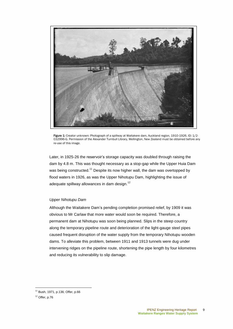
Later, in 1925-26 the reservoir‟s storage capacity was doubled through raising the
dam by 4.8 m. This was thought necessary as a stop-gap while the Upper Huia Dam
was being constructed.11
Despite its now higher wall, the dam was overtopped by
flood waters in 1926, as was the Upper Nihotupu Dam, highlighting the issue of
adequate spillway allowances in dam design.12
Upper Nihotupu Dam
Although the Waitakere Dam‟s pending completion promised relief, by 1909 it was
obvious to Mr Carlaw that more water would soon be required. Therefore, a
permanent dam at Nihotupu was soon being planned. Slips in the steep country
along the temporary pipeline route and deterioration of the light-gauge steel pipes
caused frequent disruption of the water supply from the temporary Nihotupu wooden
dams. To alleviate this problem, between 1911 and 1913 tunnels were dug under
intervening ridges on the pipeline route, shortening the pipe length by four kilometres
and reducing its vulnerability to slip damage.
11
Bush, 1971, p.136; Offer, p.66
12 Offer, p.76
Figure 1: Creator unknown: Photograph of a spillway at Waitakere dam, Auckland region, 1910-1926. ID: 1/2-
032996-G. Permission of the Alexander Turnbull Library, Wellington, New Zealand must be obtained before any
re-use of this image.
IPENZ Engineering Heritage Report 10
Waitakere Ranges Water Supply System
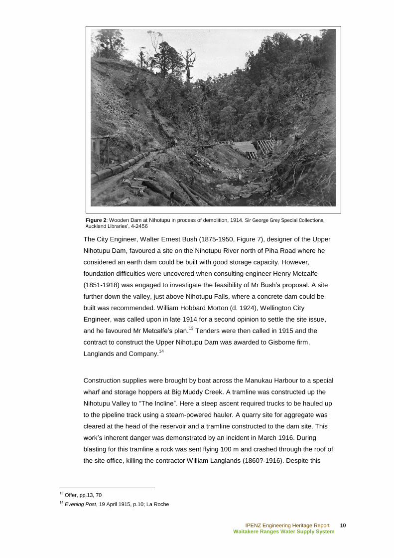
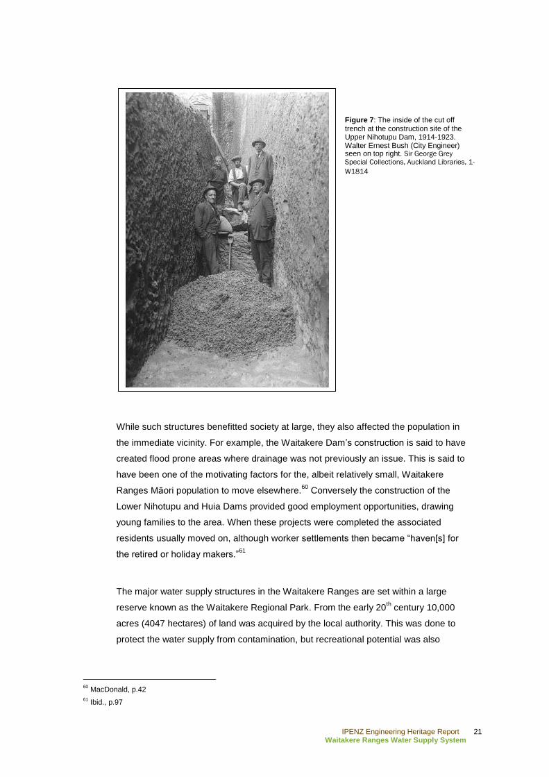
The City Engineer, Walter Ernest Bush (1875-1950, Figure 7), designer of the Upper
Nihotupu Dam, favoured a site on the Nihotupu River north of Piha Road where he
considered an earth dam could be built with good storage capacity. However,
foundation difficulties were uncovered when consulting engineer Henry Metcalfe
(1851-1918) was engaged to investigate the feasibility of Mr Bush‟s proposal. A site
further down the valley, just above Nihotupu Falls, where a concrete dam could be
built was recommended. William Hobbard Morton (d. 1924), Wellington City
Engineer, was called upon in late 1914 for a second opinion to settle the site issue,
and he favoured Mr Metcalfe‟s plan.13
Tenders were then called in 1915 and the
contract to construct the Upper Nihotupu Dam was awarded to Gisborne firm,
Langlands and Company.14
Construction supplies were brought by boat across the Manukau Harbour to a special
wharf and storage hoppers at Big Muddy Creek. A tramline was constructed up the
Nihotupu Valley to “The Incline”. Here a steep ascent required trucks to be hauled up
to the pipeline track using a steam-powered hauler. A quarry site for aggregate was
cleared at the head of the reservoir and a tramline constructed to the dam site. This
work‟s inherent danger was demonstrated by an incident in March 1916. During
blasting for this tramline a rock was sent flying 100 m and crashed through the roof of
the site office, killing the contractor William Langlands (1860?-1916). Despite this
13
Offer, pp.13, 70
14 Evening Post, 19 April 1915, p.10; La Roche
Figure 2: Wooden Dam at Nihotupu in process of demolition, 1914. Sir George Grey Special Collections,
Auckland Libraries’, 4-2456
IPENZ Engineering Heritage Report 11
Waitakere Ranges Water Supply System
setback for the company the contract continued under the control of Mr Langlands‟
partner.15
As with the construction of the Waitakere Dam, progress was hindered by heavy rain.
Flooding of the site caused several washouts, tunnel collapses, and delays in the
transportation of materials. These difficulties were compounded by the major
shortages of labourers and materials caused by World War One. In the four years to
1919 construction had not progressed past completing the foundations and some
concrete being poured.16
During this period the continuing installation of flush toilets in Auckland city, and
increases in population, the supply rapidly increased local water consumption. The
influx of people during the decade from 1910 to 1920 saw Auckland‟s population
double to over 150,000.17
As such, the slow progress at the Upper Nihotupu Dam‟s
slow progress put considerable pressure on the Council.18
To expedite additional
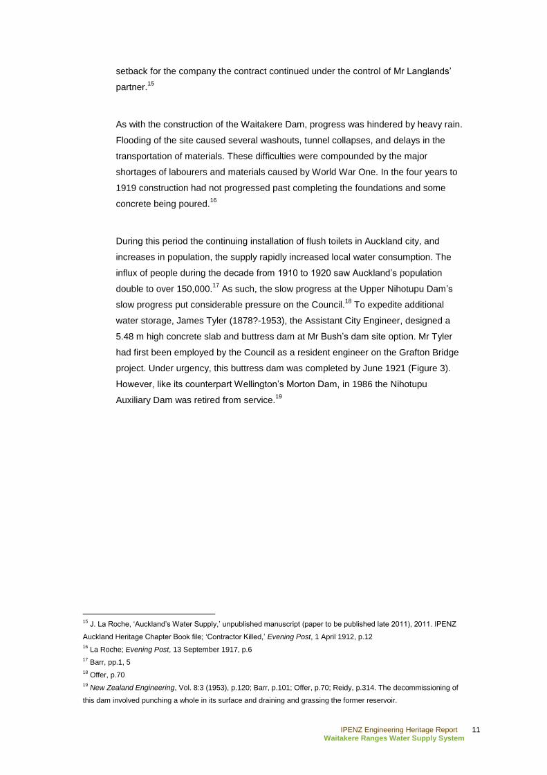
water storage, James Tyler (1878?-1953), the Assistant City Engineer, designed a
5.48 m high concrete slab and buttress dam at Mr Bush‟s dam site option. Mr Tyler
had first been employed by the Council as a resident engineer on the Grafton Bridge
project. Under urgency, this buttress dam was completed by June 1921 (Figure 3).
However, like its counterpart Wellington‟s Morton Dam, in 1986 the Nihotupu
Auxiliary Dam was retired from service.19
15
J. La Roche, „Auckland‟s Water Supply,‟ unpublished manuscript (paper to be published late 2011), 2011. IPENZ
Auckland Heritage Chapter Book file; „Contractor Killed,‟ Evening Post, 1 April 1912, p.12
16 La Roche; Evening Post, 13 September 1917, p.6
17 Barr, pp.1, 5
18 Offer, p.70
19 New Zealand Engineering, Vol. 8:3 (1953), p.120; Barr, p.101; Offer, p.70; Reidy, p.314. The decommissioning of
this dam involved punching a whole in its surface and draining and grassing the former reservoir.
IPENZ Engineering Heritage Report 12
Waitakere Ranges Water Supply System
In 1922 the Council touted that “Auckland occupies a high position among the
municipalities of the Dominion. Its civil engineering works are large and include at the
present time the erection of two dams…The smaller is practically finished [at the time
of writing], and the larger will be completed in 1923.”20
However the completion date
for the Upper Nihotupu Dam was not as assured as the Council would have liked.
Langlands‟ contract continued to get further behind. A request for an extension of
time in January 1921 was refused and Council took over control of the work using its
own engineering staff and day labour. Mr Tyler was directed to complete the dam by
1923. He reorganised the whole project with separate supply contracts for cement
and sand. Under his leadership the tramway was re-graded and the wooden rails
were replaced with steel from the Waitakere tramline. He also reorganised the quarry
and purchased new locomotives, along with other improvements.21
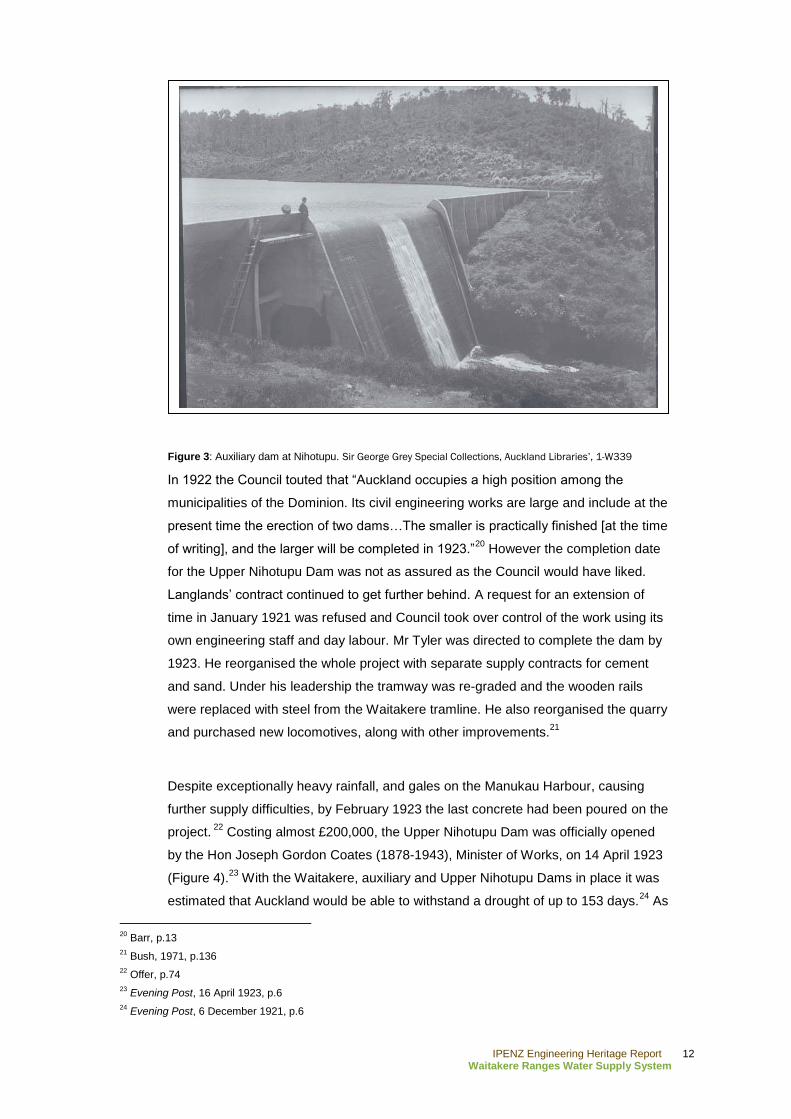
Despite exceptionally heavy rainfall, and gales on the Manukau Harbour, causing
further supply difficulties, by February 1923 the last concrete had been poured on the
project. 22
Costing almost £200,000, the Upper Nihotupu Dam was officially opened
by the Hon Joseph Gordon Coates (1878-1943), Minister of Works, on 14 April 1923
(Figure 4).23
With the Waitakere, auxiliary and Upper Nihotupu Dams in place it was
estimated that Auckland would be able to withstand a drought of up to 153 days.24
As
20
Barr, p.13
21 Bush, 1971, p.136
22 Offer, p.74
23 Evening Post, 16 April 1923, p.6
24 Evening Post, 6 December 1921, p.6
Figure 3: Auxiliary dam at Nihotupu. Sir George Grey Special Collections, Auckland Libraries’, 1-W339
IPENZ Engineering Heritage Report 13
Waitakere Ranges Water Supply System
such the Council was comfortable that Auckland would have a liberal supply of water
to sustain the current population.25
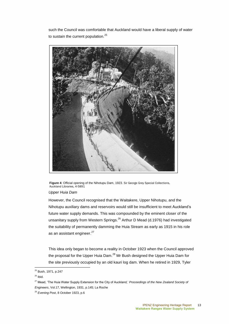
Upper Huia Dam
However, the Council recognised that the Waitakere, Upper Nihotupu, and the
Nihotupu auxiliary dams and reservoirs would still be insufficient to meet Auckland‟s
future water supply demands. This was compounded by the eminent closer of the
unsanitary supply from Western Springs.26
Arthur D Mead (d.1976) had investigated
the suitability of permanently damming the Huia Stream as early as 1915 in his role
as an assistant engineer.27
This idea only began to become a reality in October 1923 when the Council approved
the proposal for the Upper Huia Dam.28
Mr Bush designed the Upper Huia Dam for
the site previously occupied by an old kauri log dam. When he retired in 1929, Tyler
25
Bush, 1971, p.247
26 Ibid.
27 Mead, „The Huia Water Supply Extension for the City of Auckland,‟ Proceedings of the New Zealand Society of
Engineers, Vol.17, Wellington, 1931, p.145; La Roche
28 Evening Post, 8 October 1923, p.6
Figure 4: Official opening of the Nihotupu Dam, 1923. Sir George Grey Special Collections,
Auckland Libraries, 4-5891
IPENZ Engineering Heritage Report 14
Waitakere Ranges Water Supply System
took over the management of the project. Around this time Mead was promoted to the
role of Waterworks Engineer, a position he retained until 1953.29
During the period
when the dam was being constructed the Council received alarming reports regarding
the purity of the current water supply. As a result Nihotupu and Waitakere filter
stations were constructed, and one also for the Huia supply when that dam began
feeding into the system.30
The Council decided to build the Upper Huia Dam themselves using day labour
because of the past experience at the Waitakere and Upper Nihotupu Dams when
the contractors had not being able to complete the works on both occasions. Work
commenced in 1924 under the direction of resident engineer H. E. Goldsbro (d.1962)
after further investigation confirmed the location for the Upper Huia Dam.31
In 1927 it
was recorded that 200 men were employed on the dam and associated water supply
line.32
The scale of the Upper Huia project is indicated by the size of its work camp which
included 45 buildings: huts, a cookhouse, engine shed, post office, and later a school.
“Top Camp” had electricity and its own water supply from a small dam higher in the
ranges.33
The 54 acre (22 hectare) bush-clad area which was to be flooded when the
reservoir was established, was cleared of millable timber beforehand and the
remaining scrub burnt off. Much of the timber was then used to build the huts, and for
plant construction.34
It has been noted that these types of workers camps became
increasingly common on dam construction projects in the 1920s and were the
forerunners of the permanent towns which resulted from the substantial hydro-electric
installations later in the 20th century.
35
A key issue for all the concrete dams in the Waitakere Ranges was to identify a
suitable nearby quarry site from which aggregate for concrete making could be
obtained. Therefore, the first task in the Upper Huia Dam project was to build
tramlines from the dam site to the quarry, as well as one from a new landing at Huia
Bay up the valley to the dam site. Rising 140 m in 6.4 km, the tramline from Huia Bay
29
Mead, 1931, p.145; La Roche; Offer, p.74; Reidy, p.315
30 G. W. A. Bush, 'Bush, Walter Ernest – Biography,' from the Dictionary of New Zealand Biography. Te Ara - the
Encyclopedia of New Zealand, URL: http://www.TeAra.govt.nz/en/biographies/3b61/1 (updated 1 September 2010);
La Roche
31 Mead,1931, pp.145-46
32 „Municipal Works,‟ Evening Post, 18 March 1927, p.5
33 La Roche
34 Mead, 1931, pp.154-55
35 Offer, pp.74-75

IPENZ Engineering Heritage Report 15
Waitakere Ranges Water Supply System
was a significant project in itself, involving deep cuttings, two tunnels and three main
bridges.36
Because of the elaborate preparations needed for constructing this dam,
the first concrete for the Upper Huia Dam was only poured in 1927 after the cut-off
trench had been carefully excavated using pneumatic tools.37
Explosives were not
used in this instance to prevent damage to adjacent rock structures.
As with the earlier dams, in December 1926 flooding affected the preparations for the
Upper Huia Dam. This heavy rain washed away much of the tramway and caused the
reconsideration of the spillway allowances, resulting in the design for the spillway
being enlarged.38
The Waitakere and Upper Nihotupu Dams had been severely
tested by this flooding, with the Waitakere Dam being described as a “miniature
Niagara.”39
By contrast the summer of 1927-28 was incredibly dry. This motivated the Council to
order double shifts of work on the Upper Huia Dam because they were anxious about
the city running out of water.40
Construction seems to have continued reasonably
36
Offer, p.74; Mead, 1931, pp.150-53
37 Offer, p.74
38 Mead, 1931, p.161-62
39 „News of the Day,‟ Evening Post, 25 May 1926, p.6
40 Mead, 1931, p.154
Figure 5: Huia Dam with spillway overflowing. Charles Cecil Roberts, 1933. J. T. Diamond Collection 3913
(7B). Auckland Libraries, West Auckland Research Centre

IPENZ Engineering Heritage Report 16
Waitakere Ranges Water Supply System
fluidly from then on and Mayor George Baildon (1868-1946) opened the Upper Huia
Dam on 7 December 1929.41
It was estimated that the project, including the tramway,
piping and other aspects of the system, cost the Council around £233,000.42
Lower Nihotupu Dam
Mr Bush had proposed a Lower Nihotupu Dam as early as 1915. Following the
completion of the Upper Nihotupu Dam in 1923, the Council adopted a policy of
progressive utilisation of the Upper Huia, Lower Nihotupu and Lower Huia
catchments. Preliminary investigations for the Lower Nihotupu Dam had been
undertaken in 1929, including a contour survey and test shafts at 30 m intervals to
rock foundations along the proposed dam centre line. Work did not progress much
further over the next few years because of the Great Depression and then the
outbreak of World War Two. However, water supply became a pressing issue though
during the very dry summer of 1942-43 and the completion of the Lower Nihotupu
Dam became a matter of urgency.43
Cyril Firth (1903-2003) carried out the geological investigations and designed the
Lower Nihotupu rolled fill earth dam; the first dam of this type in New Zealand. Mr
Firth completed a Master of Science degree in geology, his thesis describing the
geology of the Hunua Ranges. After working as an engineer at Manukau and Fanklin
County Councils, in 1939 He joined Superior Oil Company prospecting in Taranaki.
Based on this experience he was seconded for Government oil exploration in the
lower North Island during World War Two. Subsequently, he joined Auckland City
Council Waterworks Department in 1943 and later became the Waterworks Engineer
and Director of Auckland Regional Authority (ARA). His knowledge of geology was
passed on to many engineers who learned their skills at Auckland University School
of Engineering where he lectured part-time.44
Indeed, the work on the Lower
Nihotupu Dam spurred interest in the field of soil mechanics and soon after the
structure was completed the subject of engineering geology began to be taught at the
School of Engineering.45
Soil mechanics, and the implications for earth dams, were being investigated
internationally after World War One. However, it was not until the 1940s that the finer
41
Offer, p.76
42 Mead, 1931, pp.159-60
43 A. D. Mead, „The Lower Nihotupu Water Supply for the City of Auckland,‟ Proceedings of the New Zealand Institute
of Engineers, Vol.35, Wellington, 1949, pp.289-92
44 La Roche
45 Engineering to 1990, IPENZ, Wellington, 1990, p.9
IPENZ Engineering Heritage Report 17
Waitakere Ranges Water Supply System
points of earth dam theory had been worked out.46
The Lower Nihotupu site soil tests
showed Mr Firth that ample water tightness would be gained through controlled soil
grading, moisture content and compaction. A more traditional multiple arch concrete
gravity dam was also designed for the project. Tenders were called for both designs,
and in February 1945 Downer and Company Limited were awarded the contract to
build an earth dam. Downer‟s tender price of £286,412 was 10 per cent less than the
lowest tendered price for the concrete dam.47
An alternative to the earth dam on this
scale had not been constructed in New Zealand prior to the Lower Nihotupu Dam.
This was why the Council felt it appropriate to have a back-up concrete dam design.
An earth dam became possible by the late 1940s due to developments in soil
mechanics knowledge, and heavy machinery able to construct true to
specifications.48
The dam was officially opened by the Mayor John Andrew Charles Allum (1889-1972)
on 4 December 1948.49
Mr Mead later presented a paper on the dam to the New
Zealand Institute of Engineers in 1949 which generated a lot of discussion, with the
audience keen to learn further particulars on this ground-breaking project.50
Alternative sources to the Waitakere Ranges for Auckland‟s water began to be
pursued in the period after World War Two. The Hunua Ranges had long been
considered as a potential source of water, and as such work commenced on a dam at
Cosseys Creek in 1946.51
However, staff and material shortages delayed its
completion until 1956. To keep ahead of water supply requirements, there followed a
steady construction of roll-fill earth dams: the Upper Mangatawhiri Dam was
completed in 1965, Lower Huia in 1971, Wairoa in 1975 and Mangatangi in 1977.52
All of these structures were completed after the management of Auckland‟s water
supply was transferred to the ARA in 1967.53
46
N. Smith, A History of Dams, Secaucus, New Jersey, 1972, p.225-26
47 Mead, 1949, p.292; Evening Post, 18 November 1944, p.4; „Water Supply Dam,‟ Evening Post, 23 February 1945,
p.3
48 Offer, p.93
49 La Roche
50 Mead, 1949, pp.332-43
51 „Future Water Supply Schemes for Auckland,‟ New Zealand Engineering, Vol.3:9 (September), 1948, p.880
52 Bush, 1971, pp.359-60; „Dams in the Hunua and Waitakere Ranges,‟ Watercare Services Limited, URL:
http://www.watercare.co.nz/about-watercare/our-services/hunua-and-waitakere-dams-water/Pages/default.aspx
(accessed 2 August 2011)
53 G. W. A. Bush, Advance in Order: The Auckland City Council from centenary to reorganisation, 1971-1989,
Auckland, 1991, p.82
IPENZ Engineering Heritage Report 18
Waitakere Ranges Water Supply System
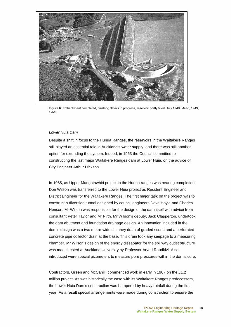
Lower Huia Dam
Despite a shift in focus to the Hunua Ranges, the reservoirs in the Waitakere Ranges
still played an essential role in Auckland‟s water supply, and there was still another
option for extending the system. Indeed, in 1963 the Council committed to
constructing the last major Waitakere Ranges dam at Lower Huia, on the advice of
City Engineer Arthur Dickson.
In 1965, as Upper Mangatawhiri project in the Hunua ranges was nearing completion,
Don Wilson was transferred to the Lower Huia project as Resident Engineer and
District Engineer for the Waitakere Ranges. The first major task on the project was to
construct a diversion tunnel designed by council engineers Dave Hoyle and Charles
Henson. Mr Wilson was responsible for the design of the dam itself with advice from
consultant Peter Taylor and Mr Firth. Mr Wilson‟s deputy, Jack Clapperton, undertook
the dam abutment and foundation drainage design. An innovation included in the
dam‟s design was a two metre-wide chimney drain of graded scoria and a perforated
concrete pipe collector drain at the base. This drain took any seepage to a measuring
chamber. Mr Wilson‟s design of the energy dissapator for the spillway outlet structure
was model tested at Auckland University by Professor Arved Raudkivi. Also
introduced were special pizometers to measure pore pressures within the dam‟s core.
Contractors, Green and McCahill, commenced work in early in 1967 on the £1.2
million project. As was historically the case with its Waitakere Ranges predecessors,
the Lower Huia Dam‟s construction was hampered by heavy rainfall during the first
year. As a result special arrangements were made during construction to ensure the
Figure 6: Embankment completed, finishing details in progress, reservoir partly filled, July 1948. Mead, 1949, p.328

IPENZ Engineering Heritage Report 19
Waitakere Ranges Water Supply System
embankment was shaped in a way which meant it could be quickly sealed off and
shielded from rain. By March 1971 the embankment was completed and the official
opening ceremony was held on 30 September 1971.54
54
Bush, 1971, p.360; La Roche
IPENZ Engineering Heritage Report 20
Waitakere Ranges Water Supply System
Social narrative
Dams were constructed in New Zealand from early in the history of earnest European
settlement. There were a number of uses in the early period for this type of human
intervention to control water, such as in gold extraction or providing water supplies for
the populous. These usually small structures were prolific, numbering in the
thousands nationally. However, the public infrastructure functions of dams expanded
in the early 20th century to include large scale structures for hydro-electric power
generation. These became possible because of technological developments and
greater understanding of how concrete could be utilised.55
As a basic societal necessity, pressures on the existing early water supply grew as
the population of New Zealand did. This was a particular concern in Auckland, which
has long been this country‟s largest city, but water supply development was also
underway in Wellington and other centres during the late 19th and early 20
th
centuries.56
Water supply became the responsibility of local authorities nationally
reasonably early, along with other essential services, such as sewage and refuse
disposal.57
Of course, aside from being important personally because of the provision
for drinking water, adequate water supply systems were especially important in
industry, as well as for activities like fire fighting.58
In particular, the population density in Auckland led to the construction of the first
dam in the Waitakere Ranges. The gradual expansion into a group of dams reflects
the on-going growth of the region during the 20th century. The catchment in the
ranges quickly became the major source of water for the city.59
The Waitakere
Ranges Water Supply System remains an important asset for Auckland amongst
other sources which began to be incorporated into Auckland‟s water supply from the
mid - 20th century.
55
Offer , pp.13, 16
56 Ibid., p.38
57 Bush, 1991, p.70
58 Offer, p.16
59 Barr, p.103
IPENZ Engineering Heritage Report 21
Waitakere Ranges Water Supply System
While such structures benefitted society at large, they also affected the population in
the immediate vicinity. For example, the Waitakere Dam‟s construction is said to have
created flood prone areas where drainage was not previously an issue. This is said to
have been one of the motivating factors for the, albeit relatively small, Waitakere
Ranges Māori population to move elsewhere.60
Conversely the construction of the
Lower Nihotupu and Huia Dams provided good employment opportunities, drawing
young families to the area. When these projects were completed the associated
residents usually moved on, although worker settlements then became “haven[s] for
the retired or holiday makers.”61
The major water supply structures in the Waitakere Ranges are set within a large
reserve known as the Waitakere Regional Park. From the early 20th century 10,000
acres (4047 hectares) of land was acquired by the local authority. This was done to
protect the water supply from contamination, but recreational potential was also
60
MacDonald, p.42
61 Ibid., p.97
Figure 7: The inside of the cut off trench at the construction site of the Upper Nihotupu Dam, 1914-1923. Walter Ernest Bush (City Engineer) seen on top right. Sir George Grey
Special Collections, Auckland Libraries, 1-
W1814

IPENZ Engineering Heritage Report 22
Waitakere Ranges Water Supply System
recognised.62
Indeed, it has been posited that had the Waitakere Ranges not been
identified for its water catchment, there would have been no need for protecting the
surrounding area, and the forest would most likely have been denuded to make way
for farming.63
Today there is still a recreational focus in the Waitakere Ranges, with
the dams, reservoirs, and other structures, now attractions for users of the park‟s
many walking tracks.64
Another popular feature is the Rain Forest Express. This train
ride uses the track constructed during the building of the Upper Nihotupu Dam.65
62
Barr, p.125; „The Waitakere Reserve,‟ Evening Post, 30 December 1937, p.8; Bush, 1971, p.169
63 Reidy, p.316
64 „Waitakere Ranges,‟ Auckland Regional Council, URL: http://www.arc.govt.nz/parks/our-parks/parks-in-the-
region/waitakere-ranges/ (accessed 2 August 2011)
65 „Rain Forest Express,‟ Watercare Services Limited, URL: http://www.watercare.co.nz/community/rain-forest-
express/Pages/default.aspx (accessed 2 August 2011)
IPENZ Engineering Heritage Report 23
Waitakere Ranges Water Supply System
Physical narrative
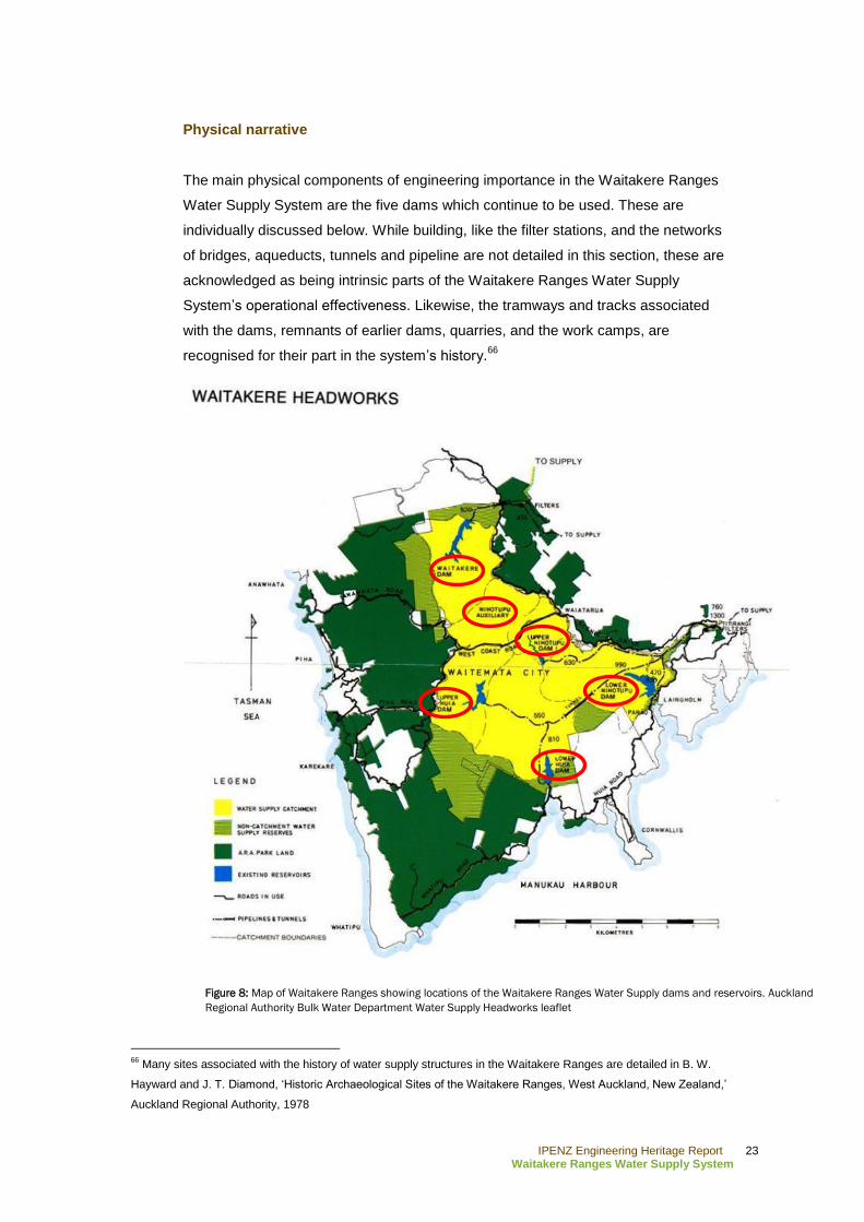
The main physical components of engineering importance in the Waitakere Ranges
Water Supply System are the five dams which continue to be used. These are
individually discussed below. While building, like the filter stations, and the networks
of bridges, aqueducts, tunnels and pipeline are not detailed in this section, these are
acknowledged as being intrinsic parts of the Waitakere Ranges Water Supply
System‟s operational effectiveness. Likewise, the tramways and tracks associated
with the dams, remnants of earlier dams, quarries, and the work camps, are
recognised for their part in the system‟s history.66
66
Many sites associated with the history of water supply structures in the Waitakere Ranges are detailed in B. W.
Hayward and J. T. Diamond, „Historic Archaeological Sites of the Waitakere Ranges, West Auckland, New Zealand,‟
Auckland Regional Authority, 1978
Figure 8: Map of Waitakere Ranges showing locations of the Waitakere Ranges Water Supply dams and reservoirs. Auckland
Regional Authority Bulk Water Department Water Supply Headworks leaflet
IPENZ Engineering Heritage Report 24
Waitakere Ranges Water Supply System
Waitakere Dam
This gravity mass concrete dam with central spillway, completed in 1910, had an
original height of 20.4 m, but this was raised to 25.3 m in 1927. This drastically
increased the capacity of the reservoir, to 1.85 million cubic metres (m³), and meant
the Waitakere Dam became the same height as the Upper Nihotupu Dam, which had
been built by this time. The Waitakere Dam 175 m long. The dam is accessible via a
walking track leading off of Scenic Drive, with a car park located opposite house
numbers 765 to 775.
Concrete had been used in small dams and weirs around New Zealand in the closing
decades of the 19th century. However, it was not until the early 20
th century that large
scale concrete gravity dams were constructed, starting with structures like the Upper
Karori Dam (1908) in Wellington, and the Waitakere Dam. However, in a move
common for this type of dam, large rocks known as “plums” or “displacers” were
imbedded in the concrete as it was poured. This reduced the volume of concrete
required and the overall cost of the dam.67
It has been noted the Waitakere Dam “has features that characterise the concrete
gravity dams built in New Zealand in the first three decades of this [the 20th]
century.”68
The Waitakere Dam‟s most obvious typical aspect was its curved design,
because this was thought to provide greater stability. In 1995 Messrs Riley, Gregory
and Wymer, worked on strengthening the Waitakere Dam by drilling down to the
foundation rock strata and tying the dam to the rock with prestressed cables. This
project also involved pinning the 1927 addition to the original dam with stressed bars
and cables.69
Upper Nihotupu Dam
Like the Waitakere Dam, the Upper Nihotupu Dam (completed 1923) is a gravity
mass concrete structure, with blue stone “plums”‟ embedded in it. Its 162 m length is
shorter than the Waitakere Dam. However, the reservoir‟s capacity of 2.36 million m³
outstrips the Waitakere Dam Reservoir. The Upper Nihotupu Dam, like the Waitakere
Dam, is curved in design with a radius of 137 m. The dam tapers from a 31 m base
width to 3.7 m across its top.70
The dam and reservoir are accessible using various
Waitakere Ranges walking tracks, like the Huia Dam and Nugget tracks.
67
Offer, pp.66, 202; New Zealand Historic Places Trust, Upper Karori Dam, Category II historic place (Record
no.7749
68 Offer, p.68
69 Ibid.
70 Barr, p.101
IPENZ Engineering Heritage Report 25
Waitakere Ranges Water Supply System
In 2009 Brian Perry Civil undertook work at the dam on behalf of Watercare Services
Limited. This project involved upgrading the intake valves so they could be operated
remotely. Other works included a new concrete valve chamber at the base of the
dam.71
The Upper Nihotupu Dam Upgrade was awarded a Hynds Environmental
Award.72
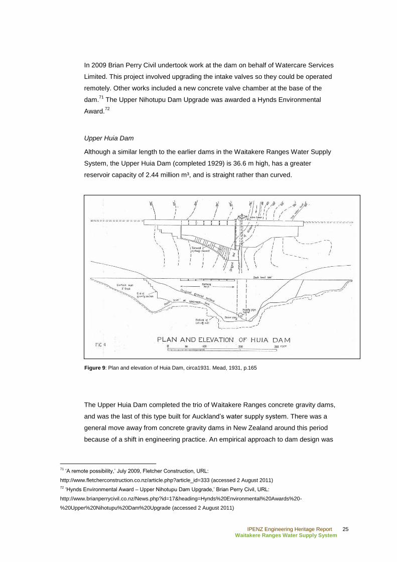
Upper Huia Dam
Although a similar length to the earlier dams in the Waitakere Ranges Water Supply
System, the Upper Huia Dam (completed 1929) is 36.6 m high, has a greater
reservoir capacity of 2.44 million m³, and is straight rather than curved.
The Upper Huia Dam completed the trio of Waitakere Ranges concrete gravity dams,
and was the last of this type built for Auckland‟s water supply system. There was a
general move away from concrete gravity dams in New Zealand around this period
because of a shift in engineering practice. An empirical approach to dam design was
71
„A remote possibility,‟ July 2009, Fletcher Construction, URL:
http://www.fletcherconstruction.co.nz/article.php?article_id=333 (accessed 2 August 2011)
72 „Hynds Environmental Award – Upper Nihotupu Dam Upgrade,‟ Brian Perry Civil, URL:
http://www.brianperrycivil.co.nz/News.php?id=17&heading=Hynds%20Environmental%20Awards%20-
%20Upper%20Nihotupu%20Dam%20Upgrade (accessed 2 August 2011)
Figure 9: Plan and elevation of Huia Dam, circa1931. Mead, 1931, p.165
IPENZ Engineering Heritage Report 26
Waitakere Ranges Water Supply System
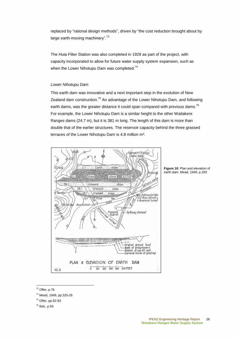
replaced by “rational design methods”, driven by “the cost reduction brought about by
large earth-moving machinery”.73
The Huia Filter Station was also completed in 1929 as part of the project, with
capacity incorporated to allow for future water supply system expansion, such as
when the Lower Nihotupu Dam was completed.74
Lower Nihotupu Dam
This earth dam was innovative and a next important step in the evolution of New
Zealand dam construction.75
An advantage of the Lower Nihotupu Dam, and following
earth dams, was the greater distance it could span compared with previous dams.76
For example, the Lower Nihotupu Dam is a similar height to the other Waitakere
Ranges dams (24.7 m), but it is 381 m long. The length of this dam is more than
double that of the earlier structures. The reservoir capacity behind the three grassed
terraces of the Lower Nihotupu Dam is 4.8 million m³.
73
Offer, p.76
74 Mead, 1949, pp.325-26
75 Offer, pp.92-93
76 Ibid., p.93
Figure 10: Plan and elevation of earth dam. Mead, 1949, p.293
IPENZ Engineering Heritage Report 27
Waitakere Ranges Water Supply System
The dam‟s concreted spillway and valve tower are on the eastern side of the
structure. A small concrete arch pedestrian bridge spans the spillway, providing
access to the valve tower, and a reinforced concrete road bridge also crosses the
channel. All these features were built in concert with the dam.77
Huia Road crosses in
front of the dam just prior to Parau, and Lower Nihotupu Road travels north beside
the reservoir from its intersection with Huia Road.
Lower Huia Dam
The Lower Huia Dam continued the tradition established in New Zealand by the
Lower Nihotupu Dam, being a long (366 m) earth dam. However, at 39.6 m high it is
nearly 15 m taller than its counterpart. Therefore, the Lower Huia Dam is the largest
of all the Waitakere Ranges dams. Consequently so is its reservoir at 6.6 million m³.
The size of this structure is reflective of New Zealand' on-going technology and dam
design development. The dam and reservoir can be viewed from Huia Dam Road.
Key physical dates
1910 Waitakere Dam completed
1921 Auxiliary Nihotupu Dam completed
1923 Upper Nihotupu Dam completed
1926-27 Waitakere Dam raised 5 m
1927 Waitakere and Nihotupu Filter Stations constructed
1929 Upper Huia Dam completed and Huia Filter Stations constructed
1948 Lower Nihotupu Dam completed
1971 Lower Huia Dam completed
1990s Waitakere Dam strengthened
77
Mead, 1949, p.301
IPENZ Engineering Heritage Report 28
Waitakere Ranges Water Supply System
C. Assessment of significance
The upland water catchment in the Waitakere Ranges has been utilised since the
early 20th century. Since then the Waitakere Ranges Water Supply System has been
of considerable significance in New Zealand, being integral to the social and
economic development and expansion of Auckland, this country‟s most populous
area. This gravitational system and its impressive dams are associated with many
leading New Zealand engineers, including: Hugh Munro Wilson, James Carlaw,
Walter Ernest Bush, Arthur D Mead, Cyril Firth, Don Wilson and others.
The group of water supply dams also demonstrates the changing face of dam
building in New Zealand, as technologies advanced and innovative engineering
theory was put into practice. The Waitakere Dam was one of the earliest large scale
concrete gravity dams in New Zealand. This became a characteristic New Zealand
dam type, of which the Upper Nihotupu and Huia Dams are other Waitakere Range
Water Supply System examples. Similarly, the Lower Nihotupu Dam is of particular
national engineering importance as the first substantial earth dam, a form which
became popular and developed further in the mid to late 20th century with structures
like the Lower Huia Dam.
Therefore, the Waitakere Water Supply System is of sufficient engineering heritage
significance to merit inclusion on the IPENZ Engineering Heritage Register.
IPENZ Engineering Heritage Report 29
Waitakere Ranges Water Supply System
D. Supporting information
List of supporting information
„Bush, Walter Ernest (1875-1950),‟ IPENZ Engineering Heritage, URL:
http://www.ipenz.org.nz/heritage/bio-detail.cfm?id=22
„Rain Forest Express,‟ Watercare Services Limited, URL:
http://www.watercare.co.nz/community/rain-forest-express/Pages/default.aspx
(accessed 2 August 2011)
Waitakere Ranges,‟ Auckland Regional Council, URL:
http://www.arc.govt.nz/parks/our-parks/parks-in-the-region/waitakere-ranges/
(accessed 2 August 2011)
Bibliography
Secondary sources
Engineering to 1990, IPENZ, Wellington, 1990
New Zealand Engineering, Vol.3:9 (1948), Vol.8:3 (1953)
Barr, J. (ed.), Municipal and Official Handbook of the City of Auckland, New Zealand,
Auckland, 1922
Bush, G. W. A., Advance in Order: The Auckland City Council from centenary to
reorganisation, 1971-1989, Auckland, 1991
Bush, G. W. A., Decently and in Order: The centennial history of the Auckland City
Council, Auckland, 1971
The Cyclopedia Company Limited, Cyclopedia of New Zealand [Auckland Provincial
District], Christchurch, 1902
Harvey, B. & T. (ed.), Waitakere Ranges: Ranges of inspiration, Auckland, 2006
IPENZ Engineering Heritage Report 30
Waitakere Ranges Water Supply System
Furkert, F.W., Early New Zealand Engineers, Wellington, 1953
La Roche, J., „Auckland‟s Water Supply,‟ unpublished manuscript (included in book to
be published late 2011), 2011. IPENZ, Auckland Heritage Chapter Book file
MacDonald, F. & R. Kerr (ed.), West: The history of Waitakere, Auckland, 2009
Mead, A. D., „The Huia Water Supply Extension for the City of Auckland,‟
Proceedings of the New Zealand Society of Engineers, Vol.17, Wellington, 1931,
pp.145-167
Mead, A. D., „The Lower Nihotupu Water Supply for the City of Auckland,‟
Proceedings of the New Zealand Institute of Engineers, Vol.35, Wellington, 1949,
pp.289-343
Offer, R. E., Walls for Water: Pioneer dam building in New Zealand, Dunmore Press,
Palmerston North, 1997
Smith, N., A History of Dams, Secaucus, New Jersey, 1972
Electronic sources
„A remote possibility,‟ July 2009, Fletcher Construction, URL:
http://www.fletcherconstruction.co.nz/article.php?article_id=333 (accessed 2 August
2011)
„Hynds Environmental Award – Upper Nihotupu Dam Upgrade,‟ Brian Perry Civil,
URL:
http://www.brianperrycivil.co.nz/News.php?id=17&heading=Hynds%20Environmental
%20Awards%20-%20Upper%20Nihotupu%20Dam%20Upgrade (accessed 2 August
2011)
Bush, G. W. A., 'Bush, Walter Ernest – Biography,' from the Dictionary of New
Zealand Biography. Te Ara - the Encyclopedia of New Zealand,
URL: http://www.TeAra.govt.nz/en/biographies/3b61/1 (updated 1 September 2010)

IPENZ Engineering Heritage Report 31
Waitakere Ranges Water Supply System
Available from Papers Past, http://paperspast.natlib.govt.nz/cgi-bin/paperspast:
Auckland Star, 9 April 1900, 30 October 1901
Evening Post, 1 April 1912, 19 April 1915, 13 September 1917, 6 December 1921, 16
April 1923, 8 October 1923, 25 May 1926, 18 March 1927, 30 December 1937, 18
November 1944, 23 February 1945
Progress, 1 May 1909