Embed Size (px)
Citation preview

Tatiana Delgado Fernández, PhDNational Commission of the Cuba Republic SDI
Ninth United Nations Regional Cartographic Conference for the America, August 2009
National Commission of the SDI of the Republic of CubaNinth United Nations Regional Cartographic Conference for the America
Ninth United Nations Regional Cartographic Conference for the America, August 2009

Understanding SDIStatus of the National SDI in Cuba (IDERC)Perspectives: Deployment and Cooperation
Ninth United Nations Regional Cartographic Conference for the America, August 2009
Ninth United Nations Regional Cartographic Conference for the America, August 2009
Systems Networks Infrastructures
Elements Components Systems Networks
Spatial Data Infrastructure
Control vs Coordination
ControlControl and
Coordination Coordination
Boundaries Close, stables
Open, Reconfigurable
Open, Reconfigurable. Virtual
GISDesktop Departments,
EnterpriseCommunities,Society
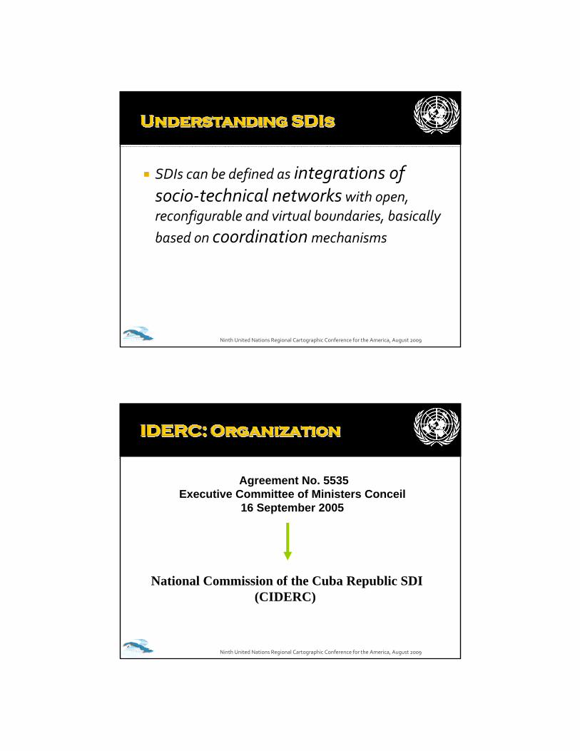
SDIs can be defined as integrations of socio‐technical networks with open, reconfigurable and virtual boundaries, basically based on coordination mechanisms
Ninth United Nations Regional Cartographic Conference for the America, August 2009
Ninth United Nations Regional Cartographic Conference for the America, August 2009
Agreement No. 5535Executive Committee of Ministers Conceil
16 September 2005
National Commission of the Cuba Republic SDI(CIDERC)

Grupos Ad‐HocTemáticos
Ninth United Nations Regional Cartographic Conference for the America, August 2009
Ninth United Nations Regional Cartographic Conference for the America, August 2009

Ninth United Nations Regional Cartographic Conference for the America, August 2009
www.iderc.co.cuwww.iderc.co.cuwww.iderc.co.cu
Geospatial Portal (GeoPortal) de la IDERCGeospatial Portal (GeoPortal) de la IDERC
Components -Services
-Portal services-Catalogue Services-Portrayal Services-Data Services
MovilWeb: Fleet Management Application
Ninth United Nations Regional Cartographic Conference for the America, August 2009
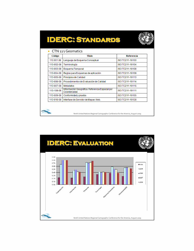
CTN 113 Geomatics
Ninth United Nations Regional Cartographic Conference for the America, August 2009
Ninth United Nations Regional Cartographic Conference for the America, August 2009
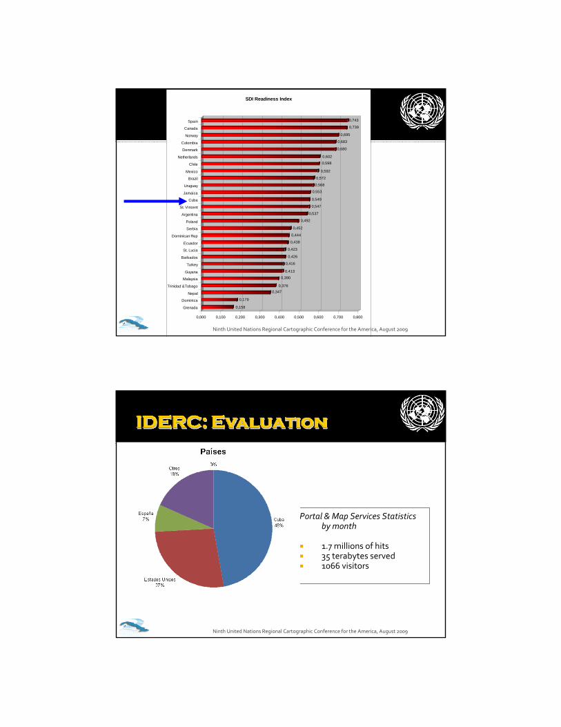
0,158
0,179
0,3470,376
0,390
0,413
0,416
0,426
0,423
0,438
0,444
0,452
0,492
0,537
0,547
0,549
0,553
0,568
0,572
0,592
0,598
0,602
0,680
0,683
0,695
0,739
0,743
0,000 0,100 0,200 0,300 0,400 0,500 0,600 0,700 0,800
Grenada
Dominica
Nepal
Trinidad &Tobago
Malaysia
Guyana
Turkey
Barbados
St. Lucia
Ecuador
Dominican Rep
Serbia
Poland
Argentina
St. Vincent
Cuba
Jamaica
Uruguay
Brazil
Mexico
Chile
Netherlands
Denmark
Colombia
Norway
Canada
Spain
SDI Readiness Index
Ninth United Nations Regional Cartographic Conference for the America, August 2009
Portal & Map Services Statistics by month
1.7 millions of hits35 terabytes served1066 visitors
Ninth United Nations Regional Cartographic Conference for the America, August 2009

Assessed the actual capacity in the province to undertake Spatial Data Infrastructures and the best practices to optimize the use of the geographic information
Strengthened the capacity to decision making and local management, by means of the delivering of geospatial data and services associated to the locality
Created References Rooms or One-Stop in municipal and provincial levels of government with access to geospatial services at local level linked to the NSDI
Built capacity in the use and exploitation of the Spatial Data Infrastructure into the stakeholders and citizen in the territory.
An Spatial Data Infrastructure properly embedded within the overall information infrastructure supporting governance processes at provincial level.
Strengthened the legal framework to support sustainable Spatial Data Infrastructures at local level.
Ninth United Nations Regional Cartographic Conference for the America, August 2009
A multi‐criteria diagnostic as starting pointA Coordination Group at local level subordinated to the Government or other politic “champion”A legal framework at local level to support the sustainability of the initiativeDefinition of policies based on principlesMiddle and long term strategyHierarchical priorities at local levelsCollaborative Alliances Capacity buildingAlignment to the actual social missions of the stakeholdersStimulation of multi level stakeholder participation and not only the official Coordination Group members (users as producers)
Ninth United Nations Regional Cartographic Conference for the America, August 2009

Organization: Fostering legal frameworks to support SDIs at different levels (territories and sectors)Education and training: Alliances with universities distributed in the whole countryApplications and Portals deployment at territory and thematic levelsProvision of data and services in a broad distribution approachActivation of cooperation at maximum level possible
Ninth United Nations Regional Cartographic Conference for the America, August 2009
Ninth United Nations Regional Cartographic Conference for the America, August 2009
1. COORDINATION is the essential function in SDIs
2. The most important progress in the SDI of the Republic of Cuba can be appreciated like the derivation of the Coordination activities of the National Commission of the IDERC with its long‐term vision (strategies) and its systematic implementation (annual working plans) in a broad participation of stakeholders approach (central, provincial and municipality levels)
3. The main future work will be focused to the DEPLOYMENT(horizontally and vertically) of the IDERC in the society, and COOPERATION insight and abroad.
Ninth United Nations Regional Cartographic Conference for the America, August 2009
Contacto:Contacto:Tatiana DelgadoTatiana [email protected]@udio.cujae.edu.cu
Coordinadora proyectoCoordinadora proyecto
CYTED IDEDESCYTED IDEDES