Embed Size (px)
Citation preview
DR. JAMES L. GREEN
NASA Planetary Science Director to Lead Off ION GNSS+ 2015
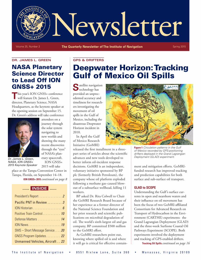
This year’s ION GNSS+ conference will feature Dr. James L. Green,
director, Planetary Science, NASA Headquarters, as the keynote speaker at the opening session on September 15. Dr. Green’s address will take conference
attendees on a journey through the solar system navigating to new worlds and showing the many recent discoveries through the “eyes” of NASA’s plan-etary spacecraft.
ION GNSS+ 2015 will take
place at the Tampa Convention Center in Tampa, Florida, on September 14–18.
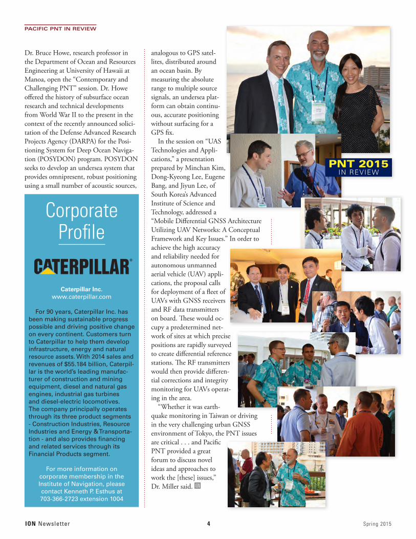
Satellite navigation technology has
provided an unprec-edented accuracy and timeliness for research-ers investigating the movement of oil spills in the Gulf of Mexico, including the disastrous Deepwater Horizon incident in 2010.
In April the Gulf of Mexico Research Initiative (GoMRI) released the first installment in a three-part series of articles about the scientific advances and new tools developed to better inform oil-incident response decisions. GoMRI is an independent, voluntary initiative sponsored by BP plc (formerly British Petroleum), the company whose oil platform exploded following a methane gas–caused blow-out of a subsurface wellhead, killing 11 workers.
BP asked Dr. Rita Colwell to Chair the GoMRI Research Board because of her experience as a former director of the National Science Foundation and her prior research and scientific pub-lications on microbial degradation of oil. The world’s sixth-largest oil and gas company, BP committed $500 million to the GoMRI effort.
As GoMRI researchers point out, knowing where spilled oil is and where it will go is critical for effective contain-
ment and mitigation efforts. GoMRI-funded research has improved tracking and prediction capabilities for both surface and sub-surface oil transport.
GLAD to SCOPEUnderstanding the Gulf ’s surface cur-rents in open and nearshore waters and their influence on oil movement has been the focus of two GoMRI-affiliated Consortium for Advanced Research on Transport of Hydrocarbon in the Envi-ronment (CARTHE) experiments: the Grand Lagrangian Deployment (GLAD) and the three-week Surfzone Coastal Oil Pathways Experiment (SCOPE). Both experiments involved the deployment and tracking of GPS-enabled drifters.
T h e I n s t i t u t e o f N a v i g a t i o n • 8 5 5 1 R i x l e w L a n e , S u i t e 3 6 0 • M a n a s s a s , V i r g i n i a 2 0 1 0 9
ION GNSS+ 2015 continued on page 8
...... INSIDE ......
President’s Report . . . . . . . . . . . . . . 2
Pacific PNT in Review . . . . . . . . . 3ION Historian . . . . . . . . . . . . . . . . . . 6Positive Train Control . . . . . . . . . . . 10Defense Matters . . . . . . . . . . . . . . 14ION News . . . . . . . . . . . . . . . . . . . . . 19SMS – Short Message Service . . . . 20GNSS Program Updates . . . . . . . . . 22Unmanned Vehicles, Aircraft . . 23 Tracking Oil Spills continued on page 16
GPS & DRIFTERS
Deepwater Horizon: Tracking Gulf of Mexico Oil Spills
NewsletterVolume 25, Number 2 The Quarterly Newsletter of The Institute of Navigation Spring 2015
Dr. James L. Green, NASA, ION GNSS+ 2015 Keynote Speaker
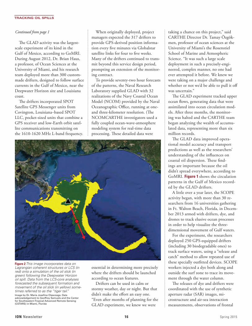
Figure 1 Circulation patterns in the Gulf of Mexico recorded by GPS-positioning drifters deployed in the Grand Lagrangian Deployment (GLAD) experiment.

ION Newsletter 2 Spring 2015
We have just concluded another yet successful ION meeting — Pacific PNT 2015 — that
took place in Honolulu, Hawaii, April 20–23, 2015. A few years ago, when the idea of expanding ION meetings to better serve the fast-growing PNT community in the Asia-Pacific region, Hawaii was selected as the most convenient (and attractive) loca-tion.
We have held two meetings there already, and both have been very successful with a substantial atten-dance of researchers and government representatives from the Asia-Pacific region. What caught my atten-tion in particular this year was a statement made by a number of colleagues from the Asia-Pacific region that it was their first participation or first presenta-tion made at an ION meeting. Clearly, the Pacific PNT meeting is serving its original purpose!
While I have no doubt that all the attendees enjoyed the beautiful settings of the meeting, and as always — perfect logistics and organization handled by the ION National Office — the technical strength of the program and networking opportunities were, similarly to the other ION meetings, the primary perk of this conference.
My favorite sessions were B2, Alternative and Collaborative Navigation; C3, Automotive and Land Vehicle Navigation; and A5, UAS Technologies and Applications. Of course, these preferences reflect a purely professional bias, as multi-sensor and collab-orative navigation is what my research team has been working on for several years.
In general, though, I found the technical program diverse and strong, and I’d like to take a moment to thank the Program Committee: Dr. Mike Miller, Dr. Jade Morton, Dr. Frank van Graas, Dr. John Raquet, the International Technical Advisory Board, and all session chairs for putting together a very interesting program and facilitating the mighty task of a paper peer review.
Aside from the technical presentations and many discussions during the coffee breaks, I enjoyed meet-ing up with friends and catching up with colleagues. A fun part was to observe the growing number of at-tendees sporting the ION’s turquoise Hawaiian logo shirts. As the meeting progressed they multiplied ex-ponentially. (Anyone who did not manage to buy one yet — please contact the ION National Office. The shirts are great and come in all men’s and women’s sizes! You can also get a matching pair of flip-flops, perfect attire for the next Pacific PNT in 2017!)
Incidentally, those of you who may wonder if Dr. Frank van Graas also wore a Hawaiian shirt will not be disappointed — he did not. However, he did sport a turquoise ION Hawaiian tie hand-made by Lisa Beaty!
In conclusion, I’d like to extend my apology to a speaker in session B2, whose talk was inadvertently interrupted when I mistakenly pressed a Siri button on my (not so smart) iPhone, and she announced joyfully and loudly “I am sorry, I did not understand what you said.”
FROM THE ION PRESIDENT, DR. DOROTA GREJNER-BRZEZINSKA
Aloha, Pacific PNT
ION President Dr. Dorota Grejner-Brzezinska and Pacific PNT 2015 General Chair Dr. Mikel Miller share a post-session moment at Waikiki.

Spring 2015 3 ION Newsletter
The Purpose of the ION®
Founded in 1945, The Institute of Navigation
is the world’s premier non-profit professional society dedicated to the advancement of the art
and science of positioning, navigation and timing.
2015 Executive CommitteePresident:
Dr. Dorota Grejner-Brzezinska
Executive Vice President: Dr. John Raquet
Treasurer: Dr. Frank van Graas
Eastern Region Vice President: Dr. Michael Veth
Western Region Vice President: Mr. Greg Turetzky
Satellite Division Chair: Dr. John Betz
Military Division Chair: Mr. Jan Anszperger
Immediate Past President: Ms. Patricia Doherty
How to Reach the ION®
Telephone: 703-366-2723
Facsimile: 703-366-2724
Web site: http://www.ion.org
E-mail: [email protected]
The ION® National Office 8551 Rixlew Lane, Suite 360
Manassas, VA 20109
The ION® National Office Staff Executive Director: Lisa Beaty
Director of Information Technology: Rick Buongiovanni
Director of Membership & Marketing: Kenneth P. Esthus
Program/Author Liaison/ Executive Assistant: Miriam Lewis
Meeting Planner: Megan Andrews
Graphic Designer: Gwen Rhoads
Newsletter Editor: Glen Gibbons
RETURN TO HAWAII
Pacific PNT 2015 Draws Diverse Mix of Topics, Attendees
The usual strong
technical content undoubtedly was a factor, but the accessible loca-tion and pleasant environs also provided an at-traction for the 180 attendees at the second ION Pacific PNT conference held in Honolulu, Hawaii, in April.
Built around 18 technical sessions in three parallel tracks over the course of three days, the venue near Waikiki Beach “provided an intimate platform for the sharing of upcoming applications in the field of PNT,” according to Pacific PNT program co-chair, Dr. Jade Morton, Colorado State University.
“Pacific PNT 2015 greatly exceeded my expectations!” added the event’s gen-eral chair, Dr. Mikel M. Miller, Air Force Research Laboratory. “In addition to the great papers, I was especially pleased with the opportunity to network with our Pacific Rim neighbors and partners.”
The ION established International Advisory Board specifically for the bien-nial conference with representatives from eight nations supporting the program development.
“We had a number of partici-pants and session chairs from Pacific Rim countries who have not been involved in the ION com-munity before and who really enjoyed
their experience at the meeting,” Dr. Morton pointed out.
An ION innovation introduced at the premier Pacific PNT conference in 2013 were key-
note addresses that opened many of the individual sessions. Designed as subject overviews with emphasis on Asia-Pacific aspects, these were invited in some cases, given by the session chair, or selected as a notable example from among the submit-ted papers.
Among such keynotes at the 2015 Pacific PNT meeting were the following:
“Recent Advances in Retrieval of Ocean Surface Wind Fields from GNSS-R delay-Doppler Maps,” by Nereida Alvarez Rodriguez and James L. Gar-rison, Purdue University, in the session on “Earthquake and Environmental Monitoring with GNSS.” This presenta-tion outlined the NASA Cyclone Global Navigation Satellite System (CYGNSS) mission to measure the surface wind speeds in the inner core of tropical cyclones. To accomplish this, CYGNSS will use a constellation of eight nano-satellites, evenly spaced within the same
orbit, each carrying a GNSS reflectom-etry (GNSS-R) receiver to observe both direct and reflected signals.
“Challenges in Long-range Underwater Positioning: Steps Toward ‘UGPS,’” by
ION Newsletter 4 Spring 2015
PACIFIC PNT IN REVIEW
Dr. Bruce Howe, research professor in the Department of Ocean and Resources Engineering at University of Hawaii at Manoa, open the “Contemporary and Challenging PNT” session. Dr. Howe offered the history of subsurface ocean research and technical developments from World War II to the present in the context of the recently announced solici-tation of the Defense Advanced Research Projects Agency (DARPA) for the Posi-tioning System for Deep Ocean Naviga-tion (POSYDON) program. POSYDON seeks to develop an undersea system that provides omnipresent, robust positioning using a small number of acoustic sources,
analogous to GPS satel-lites, distributed around an ocean basin. By measuring the absolute range to multiple source signals, an undersea plat-form can obtain continu-ous, accurate positioning without surfacing for a GPS fix.
In the session on “UAS Technologies and Appli-cations,” a presentation prepared by Minchan Kim, Dong-Kyeong Lee, Eugene Bang, and Jiyun Lee, of South Korea’s Advanced Institute of Science and Technology, addressed a “Mobile Differential GNSS Architecture Utilizing UAV Networks: A Conceptual Framework and Key Issues.” In order to achieve the high accuracy and reliability needed for autonomous unmanned aerial vehicle (UAV) appli-cations, the proposal calls for deployment of a fleet of UAVs with GNSS receivers and RF data transmitters on board. These would oc-cupy a predetermined net-work of sites at which precise positions are rapidly surveyed to create differential reference stations. The RF transmitters would then provide differen-tial corrections and integrity monitoring for UAVs operat-ing in the area.
“Whether it was earth-quake monitoring in Taiwan or driving in the very challenging urban GNSS environment of Tokyo, the PNT issues are critical . . . and Pacific PNT provided a great forum to discuss novel ideas and approaches to work the [these] issues,” Dr. Miller said. ION I
CorporateProfile
Caterpillar Inc.www.caterpillar.com
For 90 years, Caterpillar Inc. has been making sustainable progress possible and driving positive change on every continent. Customers turn to Caterpillar to help them develop infrastructure, energy and natural resource assets. With 2014 sales and revenues of $55.184 billion, Caterpil-lar is the world’s leading manufac-turer of construction and mining equipment, diesel and natural gas engines, industrial gas turbines and diesel-electric locomotives. The company principally operates through its three product segments - Construction Industries, Resource Industries and Energy & Transporta-tion - and also provides financing and related services through its Financial Products segment.
For more information on corporate membership in the Institute of Navigation, please contact Kenneth P. Esthus at 703-366-2723 extension 1004
PNT 2015IN REVIEW

Spring 2015 5 ION Newsletter
International Association of Institutes of Navigation World Congress 2015
Prague, Czech Republic, Clarion Congress Hotel Prague20–23 October 2015
al Association
IAIN 2015 News
Topics of the World Congress 2015
Congress venue
Congress Secretariat
1. Satellite Navigation Systems (GPS, GLONASS, GALILEO, BEIDOU/COMPASS, QZSS, etc.)
2. Augmentation Systems (SBAS, GBAS, etc.)3. GNSS Modernization4. Signal Processing in Navigation Systems and
Systems Integration5. GNSS Receivers and Antenna Technologies6. Interference and Spectrum Management, Jamming
and Spoofi ng7. Autonomous Navigation8. MEMS, Atomic Clock and Micro PNT9. Space and Atmospheric Weather Effects on GNSS10. Aviation Applications11. Marine Applications12. Terrestrial Applications
13. Precision Agriculture and Machine Control Applications14. Healthcare Applications15. Urban and Indoors Applications16. Automobile Navigation17. Space Applications and Remote Sensing18. Precise Positioning, RTK19. Radar and Alternative Sensors20. GNSS Environmental Monitoring21. Ionosphere Monitoring with GNSS22. Algorithms and Methods23. Collaborative Methods24. Alternative Signals for PNT25. Backups to GNSS26. Time and Frequency Distribution27. Other PNT Topics
Clarion Congress Hotel Prague ****Freyova 33, 190 00 Prague 9 – Vysočany, Czech Republic
GUARANT International, Na Pankráci 17, 140 21 Prague 4, Czech RepublicTel.: +420 284 001 444, fax: +420 284 001 448, e-mail: [email protected] www.iain2015.org
IAIN2015_letA5.indd 1 30.1.15 2:02
ION Newsletter 6 Spring 2015
Determining location is not only the fundamen-tal navigation objective; it’s a primal human
instinct. And fear of being lost permeates all human behavior.
So, I started to explore the meaning of location with a thesaurus and a book of synonyms. Many good words conveyed the general idea: site, place, po-sition, setting, scene, locality, whereabouts, situation, locale, spot, area, district, neighborhood, part, point, region, section, station, venue, bearings, fix, hole, locus, post, tract, turf, and neck of the woods.
I then tried to find the opposite, or antonym, of location — but it wasn’t there! I combed the the-saurus, antonyms.com, synonyms.com, ask.com, Google, wordhippo.com, and SIRI Apple’s personal assistant in cyberspace. None of these sources pro-vided even a single word that conveyed a meaning that was the opposite of location.
SIRI, in her admirable, but often confounding quest to please, did come up with the little town of Busselton, Australia, when I asked. It turns out that it’s the closest city whose coordinates are the antipode (opposite) of my home in Richboro, Pennsylvania. Knowing the antipodal city of my residence adds to my repository of navigation-related useless informa-tion, but it was not what I was searching for.
Not having the opposite of a location has also become an implicit guarantee of a large Department of Defense initiative referred to as Assured Position, Navigation, and Time. “Assured” means a guarantee that you will always know your location. This clearly shows the importance of navigation to the govern-ment, as I do not know of government programs called Assured Food or Assured Shelter or Assured Equality.
Returning to our theme, however: What can explain this dearth of antonyms for location? It appears that humans don’t like the idea of being lost or having no place in the world. Even though Canadian musician Neil Young suggested in the title of his second album that “Everybody Knows This Is Nowhere,” being the opposite of somewhere is such a visceral fear that it appears to invoke a denial of the possibility.
So, I turned to some of the world’s philosophers, poets, songwriters, and authors for further explana-tions of this phenomenon. The following quotations
and excerpts reflect humanity’s agony and ecstasy associated with lacking a location or, in other words, being lost.
“Some things were better lost than found.” — Stephen King, The Dead Zone
“How would it be,” said Pooh slowly, “if, as soon as we’re out of sight of this Pit, we try to find it again?”
“What’s the good of that?” said Rabbit.“Well,” said Pooh, “we keep looking for Home
and not finding it, so I thought that if we looked for this Pit, we’d be sure not to find it, which would be a Good Thing, because then we might find something that we weren’t looking for, which might be just what we were looking for, really.”
— A. A. Milne
“I’ve never been lost, but I was mighty turned around for three days once.”
— Daniel Boone
FROM THE ION HISTORIAN, MARVIN MAY
Knowing where we are is a basic human need.
Nowhere, Man
“In the midway of this our mortal life, I found me in a gloomy wood, astray.” Dante, the Inferno, Canto 1, lines 1, 2. Illustration by Gustave Dore 1861. Public domain image, via the Gutenberg Project
Marvin B. May is Chief Navigation Technologist at Pennsylvania State University Applied Research Center (PSU/ARL) Naviga-tion Research and Development Center in Warmin-ster. His email is <[email protected]>

Spring 2015 7 ION Newsletter
“We are forlorn like children, and expe-rienced like old men, we are crude and sorrowful and superficial — I believe we are lost.”
— Erich Maria Remarque, All Quiet on the Western Front
“There is no one to find me now, is there? This time I have to find our own way, and it is hard, so hard.”
— George R.R. Martin
“You can lose your way anywhere.” Christine Heppermann, from
Poisoned Apples: Poems for You, My Pretty
“He’s a real Nowhere ManSitting in his nowhere landMaking all his nowhere plans for nobody.”
— The Beatles
Unlike the Defense Department, philosophers and authors cannot give us a guarantee against getting lost, but they
offer some hope of finding oneself in the following observations:
“It was strange how you didn’t realize how much you loved a place until you had lost it completely.”
— Kameron Hurley, Rapture
“Yesterday, I got lost.You did too.So what?People get lost all the time.It’s just a matter of finding yourself, and treasuring that.”
— Maddie Hamplie
“Getting lost is not fatal. Almost every time, it will make your world.”
— Julien Smith
“Cut off from everything that was familiar to him, unable to discover even a single point of reference, he saw that his steps, by taking him nowhere, were taking him nowhere but into himself.
He was wandering inside himself, and he was lost. Far from troubling him, this state of being lost became a source of happiness, of exhilaration. He breathed it into his very bones. As if on the brink of some previously hidden knowledge, he breathed it into his very bones and said to himself, almost triumphantly: I am lost.”
— Paul Auster, The Invention of Solitude
“Sometimes when you lose your way in the fog, you end up in a beautiful place! Don’t be afraid of getting lost!”
— Mehmet Murat ildan
“Whether you are lost in the darkness or dance in the light is entirely up to you.”
— Steven Redhead, Unleash The Power of Your Heart and Mind
“True navigation begins in the human heart. It is the most important map of all.”
— Elizabeth Kapu’uwasilani Lindsey ION
ION HISTORIAN
ION Newsletter 8 Spring 2015
ION GNSS+ 2015
Over the last few decades, NASA has sent instrumented robotic probes to all of the planets in the Solar System, the moons of Jupiter and Saturn, asteroids, and comets.
“We have discovered beautiful, strange, mysterious, and puzzling worlds,” says Dr. Green. “In the last sev-eral years alone, our understanding of the origin and evolution of our solar system
has changed dramatically. Literally our foundations of knowledge have been reestablished!”
As the director of Planetary Science, Dr. Green is responsible for the U.S. space agency’s exploration of our solar system, including astrobiology research. Under his leadership, a number of recent planetary science mission events have been successfully completed, including the following:
• the NEW HORIZONS space probe, which is scheduled to reach Pluto on July 14
• the 10-year MErcury Surface, Space ENvironment, GEochemistry, and Ranging (MESSENGER) mission, which ended April 30 as the space-craft, its fuel exhausted, crashed into the surface of planet
• the launch of JUNO mission to im-prove our understanding of the solar
Perhaps a Cigar with That Cuban Sandwich?
ION GNSS+ 2015 attendees will be arriving in Tampa, Florida, in an era of changing U.S.-Cuba relations that have a
special historical resonance for the city’s residents.Current events have given a new prominence to Tampa’s long
history as a trading partner, political sanctuary, and jumping-off point for its island neighbor a short stretch down the western coast and across the Florida Straits. Ybor City — which many ION-goers discovered last year to be an exciting center of art, nightlife, and entertainment for greater Tampa — is one of only two U.S. National Historic Landmark districts in the state of Florida.
Cuban culture and personalities comprise a large part of that history.
A group of cigar manufacturers led by Vicente Martinez-Ybor, a Spanish native who became a prominent fabricante de cigarros in Cuba before coming to Florida, founded Ybor City as an in-dependent municipality in 1885. Two years later, Tampa — hav-
ing been incorporated itself only in 1849 — annexed the town. By the late 1920s, Ybor factories were producing nearly 500 mil-lion hand-rolled cigars every year, giving Tampa the nickname of the “Cigar City,” according to its Wikipedia entry.
Jose Martí, a Cuban hero in the nation’s struggle for inde-pendence from Spain, visited Ybor City and West Tampa many times, delivering incendiary speeches to large audiences of Cu-bans and Cuban-Americans there. A small plot of land in Ybor City, the site of a house where the revolutionary leader frequent-ly stayed during his visits, is now the site of the Jose Martí Park.
Tampa also served as the embarkation port for thousands of U.S. troops sent to intervene in the Cuban struggle for libera-tion, which escalated into the larger Spanish-American War of 1898.
The area underwent a decline during and after the Great De-pression of the 1930s as the popularity of cigars was supplanted by less expensive cigarettes. Revitalization of Ybor City began in the 1980s with an influx of artists seeking low-cost housing and studio space.
But the Cuban cultural and demographic presence remained strong in Ybor City and, more generally, Tampa with numerous restaurants, museums, and cultural venues throughout the area.
Recent efforts to restore normal political and economic rela-tions between Cuba and the United States have re-energized the Cuban American community. In April, the Tampa City Council passed a resolution endorsing the idea of establishing a Cuban consulate there, a proposal also endorsed by the Greater Tampa Chamber of Commerce, which has long advocated stronger ties between the city and Cuba, according to a recent New York Times article.
Ybor City is readily accessible from the ION GNSS+ Confer-ence and hotel venues via the historic TECO Line Streetcar that has a stop conveniently located midway between the Embassy Suites and Tampa Marriot Waterside hotels and the convention center. A map of the streetcar system can be found online at <http://www.tecolinestreetcar.org/about/maps/downtown_net-work.pdf>.
El Centro Ybor in Tampa, Florida, site of the former Spanish social club, El Centro Español, and now at the heart of a family-oriented shopping complex and movie theater. Photo by Bobak Ha’Eri, used under terms of the Wikimedia Creative Commons Attribution-Share Alike 2.5 Generic license.
ION GNSS+ 2015 continued from page 1

Spring 2015 9 ION Newsletter
ION GNSS+ 2015
Due June 30
Kepler Award NominationsThe purpose of the Johannes Kepler Award is to honor an individual for sustained and significant contributions to the development of satellite naviga-tion. The winner of this award will be determined by a special nominating committee. The Kepler Award is present-ed only when deemed appropriate. All members of The Institute of Navigation are eligible for nomination. We are encouraged to submit the names of individuals for consideration.
To submit a nomination, go to the ION website at www.ion.org. Click on Awards, scroll down, click on Kepler Award, then click on the Awards form for complete nomination instructions. Nominations must be received by June 30. Nomination packages may be sent to: Satellite Division Awards Committee Chair, The Institute of Navigation, 8551 Rixlew Lane, Suite 360, Manassas, VA 20109.
Due June 30
Parkinson Award NominationsGraduate students in GNSS technol-ogy, applications, or policy who have completed a single-author thesis or dis-sertation and who are ION members are eligible for this prestigious award and $2,500 honorarium. Nominations are to be submitted by a regular research fac-ulty member of a college or university.
This award honors Dr. Bradford W. Parkinson for establishing the U.S. Global Positioning System and the Satellite Division of The Institute of Navigation.
For application details and entry rules, go to www.ion.org. Nominations must be received by June 30.
system’s beginnings by revealing the origin and evolution of Jupiter
• launch of the Gravity Recovery and Interior Laboratory (GRAIL) A and B spacecraft, which successfully mapped the Moon’s gravitation field
• the spacecraft Dawn’s encounter with the asteroid Vesta
• the landing of the Mars Science Labo-ratory and Curiosity rover on Mars. Dr. Green has published more than
100 scientific papers on the magneto-sphere of Earth and Jupiter. He has also contributed more than 50 technical articles on various aspects of data systems and networks.
Dr. Green received his Ph.D. in physics from the University of Iowa in 1979 and worked at NASA’s Marshall Space Flight Center and Goddard Space Flight Center before becoming the director of the Plan-etary Science Division at NASA Head-quarters in 2006. In 1988 he received
the Arthur S. Flemming award presented by The George Washington University and the Arthur S. Flemming Awards Commission for outstanding individual performance in the federal government. In 1996 he received Japan’s Kotani Prize in recognition of his international science data management activities.
Sponsored by the ION’s Satellite Divi-sion, ION GNSS+ is the world’s larg-est international technical meeting and showcase of GNSS technology, products, and services and brings together interna-tional leaders in GNSS and related posi-tioning, navigation, and timing (PNT) fields to present advances, introduce new technologies, update current policy, dem-onstrate products and exchange ideas.
This years technical session tracks and chairpersons are “Mass-Market Applica-tions,” Dr. Paul McBurney, GopherHush Corporation, USA; “High Performance and Safety-Critical Applications,” Ms. Sandra Kennedy, NovAtel Inc., Canada; “System Updates, Plans and Policies,” Dr. André Hauschild, German Aerospace Center, Germany; “Multisensor Naviga-tion and Applications,” Dr. Zainab Syed, InvenSense, Canada; and “Advanced GNSS Technologies,” Dr. Grace Xingxin Gao, University of Illinois at Urbana-Champaign. The first three are designated
Using a precision formation-flying technique, the twin GRAIL spacecraft mapped the moon’s gravity field, as depicted in this artist’s rendering. Radio signals traveling between the two spacecraft provide scientists the exact measurements required as well as an uninterrupted flow of information even when the spacecraft were on the far side of the moon. Image credit: NASA/JPL-Caltech
“System and Application Tracks” and the latter three, “Peer-Reviewed Tracks.”
Program organizers for ION GNSS+ 2015 are Dr. Terry Moore, University of Nottingham, general chair; Dr. Gary Mc-Graw, Rockwell Collins, program chair; Ms. Patricia Doherty, Boston College, tutorials chair; and Dr. Dorota Grejner-Brzezinska, The Ohio State University, ION President. ION
ION Newsletter 10 Spring 2015
POSITIVE TRAIN CONTROL
Continuing incidences of explosive train accidents involving volatile
shale oil might seem to highlight the potential for a positioning and tracking system — known generically as Positive Train Control (PTC) — for the U.S. rail system, a subject of discussion for more than 45 years that has yet to come to fruition.
Oddly enough, however, the oilcar safety discussion has focused on railcar design and providing advance notice to states of oil trains moving across their ter-ritory. On May 1 the U.S. Transportation Department announced new standards for tank-car construction, new brake-system requirements, and speed limits for trains. The final rules referenced PTC developments, but not how that tech-nology would specifically be applied to regulation of oil trains.
Meanwhile, as a presentation at the recent ION Pacific PNT 2015 meeting reflected, the much denser European rail system has begun implementing its own version of PTC known as the European Railway Traffic Management System/Eu-
ropean Train Control System (ERTMS/ETCS). Europe’s interest in the subject began 20 years after the first discussion in the United States and yet the 28-member European Union (EU) appears much farther down the track toward reaching their destination.
U.S. rail companies now face a dead-line at the end of this year to install PTC systems on all Class 1 railroads and pas-senger railroads. PTC combines GNSS, trackbed sensors, wayside switching and warning signs, and dispatch centers to provide real-time monitoring of trains and automatic controls to prevent or reduce the likelihood of accidents.
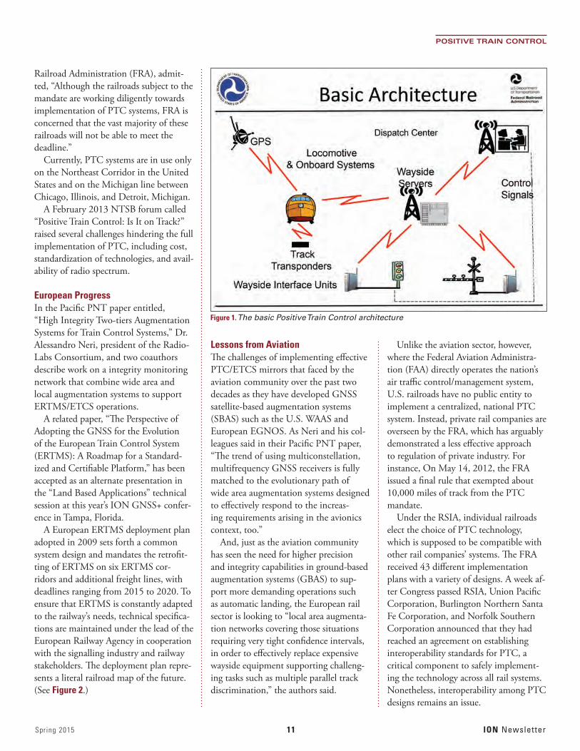
A PTC system monitors the location and movement of trains, then slows or stops any that is not being operated in ac-cordance with signal systems or operating rules. Most use GNSS, in-track circuits or transponders, or a combination of both to determine train location. (See Figure 1.)
The PTC mandate came with congres-sional passage of the Rail Safety Improve-ment Act of 2008 (RSIA) following
the collision of a Metrolink commuter train and a Union Pacific freight train in Chatsworth, California, that resulted in 25 deaths and 102 injuries. The National Transportation Safety Board (NTSB) has included PTC on its Most Wanted List every year from its inception in 1990.
Nonetheless, at an April 14 hearing on “Oversight of the Ongoing Rail, Pipeline, and Hazmat Rulemakings” held by the U.S. House Committee on Transporta-tion and Infrastructure’s Subcommittee on Railroads, Pipelines, and Hazardous Materials, NTSB Chairman Christopher Hart admitted that compliance with the PTC mandate remains in doubt.
“We know that several rail carri-ers have stated that they will not meet the 2015 deadline,” Hart said. “This is disappointing.”
At the same hearing, Sarah Feinberg, acting administrator of the Federal
A Positioning Application Still Not on Track
Positive Train Control in the United States
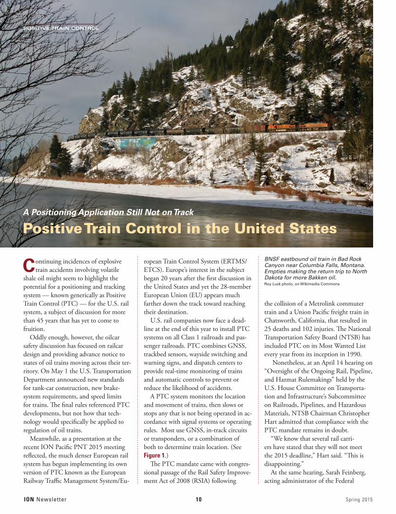
BNSF eastbound oil train in Bad Rock Canyon near Columbia Falls, Montana. Empties making the return trip to North Dakota for more Bakken oil. Roy Luck photo, on Wikimedia Commons
Spring 2015 11 ION Newsletter
POSITIVE TRAIN CONTROL
Railroad Administration (FRA), admit-ted, “Although the railroads subject to the mandate are working diligently towards implementation of PTC systems, FRA is concerned that the vast majority of these railroads will not be able to meet the deadline.”
Currently, PTC systems are in use only on the Northeast Corridor in the United States and on the Michigan line between Chicago, Illinois, and Detroit, Michigan.
A February 2013 NTSB forum called “Positive Train Control: Is It on Track?” raised several challenges hindering the full implementation of PTC, including cost, standardization of technologies, and avail-ability of radio spectrum.
European ProgressIn the Pacific PNT paper entitled, “High Integrity Two-tiers Augmentation Systems for Train Control Systems,” Dr. Alessandro Neri, president of the Radio-Labs Consortium, and two coauthors describe work on a integrity monitoring network that combine wide area and local augmentation systems to support ERTMS/ETCS operations.
A related paper, “The Perspective of Adopting the GNSS for the Evolution of the European Train Control System (ERTMS): A Roadmap for a Standard-ized and Certifiable Platform,” has been accepted as an alternate presentation in the “Land Based Applications” technical session at this year’s ION GNSS+ confer-ence in Tampa, Florida.
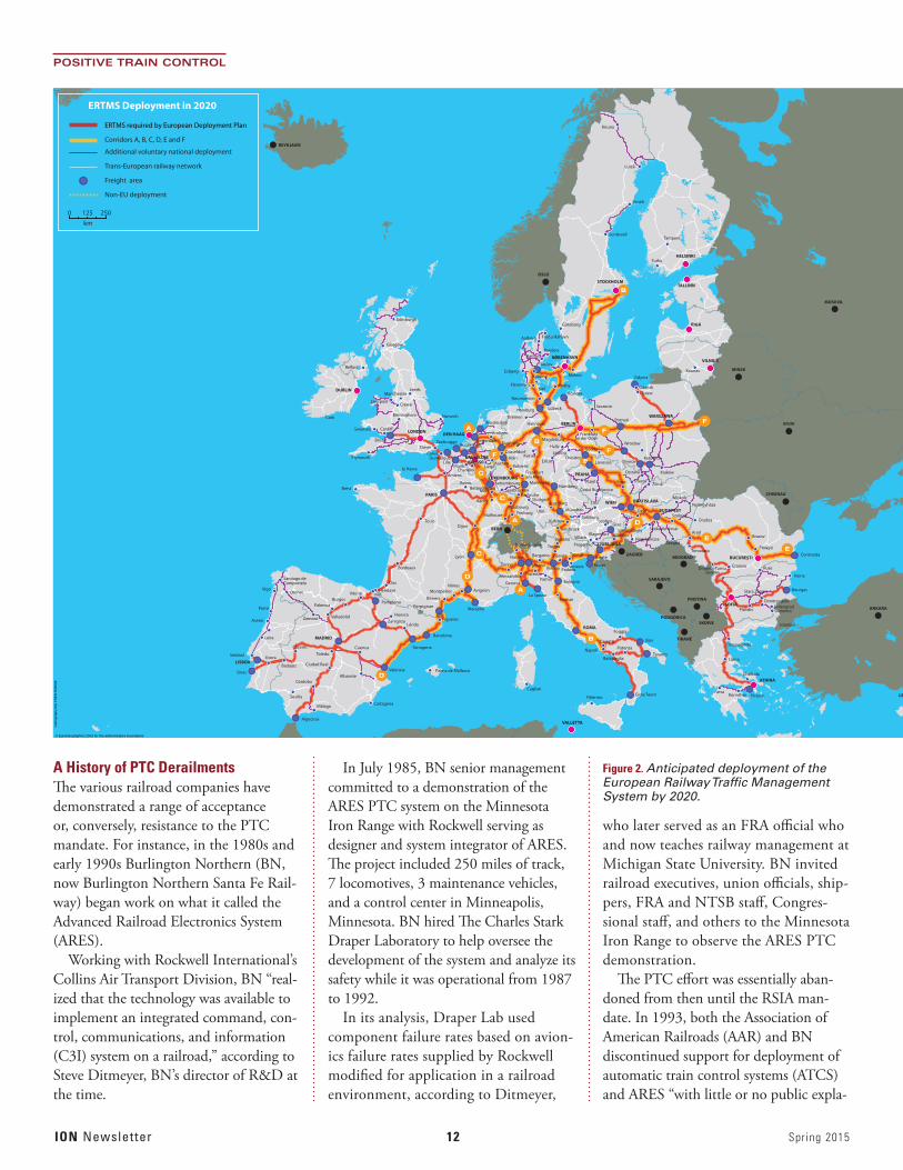
A European ERTMS deployment plan adopted in 2009 sets forth a common system design and mandates the retrofit-ting of ERTMS on six ERTMS cor-ridors and additional freight lines, with deadlines ranging from 2015 to 2020. To ensure that ERTMS is constantly adapted to the railway’s needs, technical specifica-tions are maintained under the lead of the European Railway Agency in cooperation with the signalling industry and railway stakeholders. The deployment plan repre-sents a literal railroad map of the future. (See Figure 2.)
Lessons from AviationThe challenges of implementing effective PTC/ETCS mirrors that faced by the aviation community over the past two decades as they have developed GNSS satellite-based augmentation systems (SBAS) such as the U.S. WAAS and European EGNOS. As Neri and his col-leagues said in their Pacific PNT paper, “The trend of using multiconstellation, multifrequency GNSS receivers is fully matched to the evolutionary path of wide area augmentation systems designed to effectively respond to the increas-ing requirements arising in the avionics context, too.”
And, just as the aviation community has seen the need for higher precision and integrity capabilities in ground-based augmentation systems (GBAS) to sup-port more demanding operations such as automatic landing, the European rail sector is looking to “local area augmenta-tion networks covering those situations requiring very tight confidence intervals, in order to effectively replace expensive wayside equipment supporting challeng-ing tasks such as multiple parallel track discrimination,” the authors said.
Unlike the aviation sector, however, where the Federal Aviation Administra-tion (FAA) directly operates the nation’s air traffic control/management system, U.S. railroads have no public entity to implement a centralized, national PTC system. Instead, private rail companies are overseen by the FRA, which has arguably demonstrated a less effective approach to regulation of private industry. For instance, On May 14, 2012, the FRA issued a final rule that exempted about 10,000 miles of track from the PTC mandate.
Under the RSIA, individual railroads elect the choice of PTC technology, which is supposed to be compatible with other rail companies’ systems. The FRA received 43 different implementation plans with a variety of designs. A week af-ter Congress passed RSIA, Union Pacific Corporation, Burlington Northern Santa Fe Corporation, and Norfolk Southern Corporation announced that they had reached an agreement on establishing interoperability standards for PTC, a critical component to safely implement-ing the technology across all rail systems. Nonetheless, interoperability among PTC designs remains an issue.
Figure 1. The basic Positive Train Control architecture
ION Newsletter 12 Spring 2015
POSITIVE TRAIN CONTROL
A History of PTC DerailmentsThe various railroad companies have demonstrated a range of acceptance or, conversely, resistance to the PTC mandate. For instance, in the 1980s and early 1990s Burlington Northern (BN, now Burlington Northern Santa Fe Rail-way) began work on what it called the Advanced Railroad Electronics System (ARES).
Working with Rockwell International’s Collins Air Transport Division, BN “real-ized that the technology was available to implement an integrated command, con-trol, communications, and information (C3I) system on a railroad,” according to Steve Ditmeyer, BN’s director of R&D at the time.
In July 1985, BN senior management committed to a demonstration of the ARES PTC system on the Minnesota Iron Range with Rockwell serving as designer and system integrator of ARES. The project included 250 miles of track, 7 locomotives, 3 maintenance vehicles, and a control center in Minneapolis, Minnesota. BN hired The Charles Stark Draper Laboratory to help oversee the development of the system and analyze its safety while it was operational from 1987 to 1992.
In its analysis, Draper Lab used component failure rates based on avion-ics failure rates supplied by Rockwell modified for application in a railroad environment, according to Ditmeyer,
who later served as an FRA official who and now teaches railway management at Michigan State University. BN invited railroad executives, union officials, ship-pers, FRA and NTSB staff, Congres-sional staff, and others to the Minnesota Iron Range to observe the ARES PTC demonstration.
The PTC effort was essentially aban-doned from then until the RSIA man-date. In 1993, both the Association of American Railroads (AAR) and BN discontinued support for deployment of automatic train control systems (ATCS) and ARES “with little or no public expla-
Genova
La Spezia
Milano
PiacenzaVerona
Vicenza
Trento
Bolzano
PadovaVenezia
TrevisoLyon
LiègeAachen
KoblenzCharleroi
Mons
Amsterdam
Napoli
Strasbourg
SaarbrückenKarlsruhe
MannheimBettembourgBettembourg
StuttgartAugsburg
UlmFreiburgMulhouse
Düsseldorf
Duisburg
Arnhem
München
NürnbergPlzeň
České Budĕjovice
Rotterdam
Barcelona
AntwerpenZeebrugge
Norwich
Hannover
Rostock
Lübeck
Kiel
Neumünster
Poznań
Dijon
Nancy
DunkerqueLille
Metz
Reims
Amiens
DoverCalais
Marseille
Nîmes
Béziers
Figueras
AvignonMontpellier
Valencia Palma de Mallorca
Cagliari
PalermoCartagena
Pamplona
Valladolid
Málaga
Sevilla
Córdoba
Ciudad Real
ToledoCuencaCáceres
Badajoz
Evora
Albacete
BurgosPalencia
VitoriaHendaye
Irún
Dax
Tarragona
Constanţa
Köln Kassel
Porto
Aveiro
Leira
Kraków
KatowiceGliwice
Brno Přerov
Ostrava
Žilina
Székesfehérvár
Miskolc
Arad
Szolnok
Nyíregyháza
Oradea
SzegedBrasov
Ploieşti
Bourgas
Varna
Plovdiv
PiraeusKorinthos
Thessaloníkí
Lárisa
Chalkida
Patra
Stara Zagora
DimitrovgradSvilengradOrmenio
Craiova RuseDrobeta-TurnuSeverin
Timisoara
GdanskTczew
Szczecin
Frankfurtan der Oder
Görlitz
Gdynia
Torino
AlessandriaBologna
Firenze
Foggia
Potenza
Battipaglia
Caserta
Trieste
Koper
SalzburgKufstein
Innsbruck
Linz
GrazLeoben
VillachKlagenfurt
Pragersko
Szombathely
Nagykanizsa
Győr
Maribor
Parma
Bergamo
Domodossola
Novara
Belfast
Wrocław
DresdenLovosice
Frankfurtam Main
LeipzigHalle
Erfurt
Magdeburg
Hamburg
Bremen
Istanbul
Bordeaux
Liverpool
Birmingham
Crewe
le Havre
Tours
Brest
Plymouth
Cork
ManchesterLeeds
Bristol
Cardi�Swansea
Glasgow
Edinburgh
AarhusRanders
Luleå
Umeå
Sundsvall
Kiruna
Taulov
Malmö
Göteborg
Turku
Kaunas
Tampere
RødbyFlensburg
EsbjergKolding
Aalborg Frederikshavn
Taranto
Bari
Gioia Tauro
Algeciras
Setúbal
Sines
Perpignan
ZaragozaHuesca
Lérida
VigoOrense
Santiago de Compostela
Zamora
PARIS
LUXEMBOURG
BERN
BRUXELLESBRUSSEL
ROMA
DEN HAAGLONDON
PRAHA
BUCUREŞTI
SOFIA
BEOGRAD
SARAJEVO
SKOPJE
TIRANË
ATHINA
PODGORICA
ANKARA
PRISTINA
DUBLIN
BRATISLAVA
BUDAPEST
LJUBLJANA
WIEN
BERLIN
WARSZAWA
KǾBENHAVN
OSLO
REYKJAVÍK
STOCKHOLMTALLINN
HELSINKI
RIGA
VILNIUS
MINSK
ZAGREB
LEFKOSIA
MADRID
KYJIV
MOSKVA
CHISINAU
VALLETTA
LISBOA
ERTMS Deployment in 2020
ERTMS required by European Deployment Plan
Corridors A, B, C, D, E and F
Additional voluntary national deployment
Trans-European railway network
Freight area
Non-EU deployment
0 125 250
km
Car
togr
aphy
DG
TR
EN
05/
2009
© EuroGeographics 2001 for the administrative boundaries
Figure 2. Anticipated deployment of the European Railway Traffic Management System by 2020.
Spring 2015 13 ION Newsletter
POSITIVE TRAIN CONTROL
nation,” according to a 2004 FRA report to Congress.
In a presentation at the 2013 NTSB forum, Gerhard Thelen, vice-president of operations plan-ning for Norfolk Southern Cor-poration — speaking on behalf of the AAR, said that the ARES and other PTC pilot projects “were abandoned due to communica-tions capacity and an unattainable functional Back Office System.”
Costs versus BenefitsIndeed, cost factors probably provided the largest disincentives for railroads to pursue PTC.
“BN and Rockwell manage-ment recognized early that the cost of a system like ARES would not be justified if only the costs of the accidents prevented were con-sidered,” Ditmeyer told the NTSB forum. “They realized, though, that the real-time, precise, con-tinuous information about the locations and speeds of trains and maintenance vehicles could also be used to obtain business ben-efits, such as improved meet-pass planning, shorter running times, closer spacing between trains, reduced fuel consumption and emissions, improved productivity
of maintenance crews, and higher asset utilization. The benefit-to-cost ratio of a systemwide implementation of ARES was calculated to be approximately 3-to-1.”
BN conducted analyses on all these business benefits, which were summarized in a Harvard Business School case study in 1991, he added.
In a September 1999 report to the FRA on PTC from the Railroad Safety Advisory Committee (RSAC) found that safety benefits of PTC could not support the investments needed to deploy the system. The RSAC was unable to reach conclusions regarding the non-safety benefits of PTC-related technologies.
The exercise was essentially repeated a decade later in the 2004 FRA report to
Congress that provided an updated eco-nomic analysis of the costs and benefits of positive train control and related systems “that takes into account advances in technology and system savings to carriers and shippers.”
A cost/benefit analysis by Zeta-Tech Associates undertaken as part of the FRA report estimated that a full-fledged PTC would cost railroads between $2.0 and $3.7 billion in 2003 dollars, and would only return them between $25 million and $202 million per year in benefits.
Business-related benefits, mostly driven by improvements in positioning accuracy due to GNSS, include such things as im-proved railroad productivity and reduced shipper logistical cost, created by preci-sion dispatch, improved capacity, faster and more reliable rail shipments, and diversion of freight traffic from highway to rail.
According to Zeta-Tech, shippers would receive a benefit of between $1.55 and $2.5 billion per year. PTC-preventable rail accident costs would be reduced by $40 to $96 million per year, but would be offset by volume related in-creases in rail accident costs of $20 to $40 million per year. Other benefits would come from reduced traffic accidents and air pollution due to diversion of freight from highways to more efficient railroads.
The total net societal benefits would range from a low of $2.1 billion per year in 2010 to a high of $3.9 billion in 2020, according to Zeta-Tech. During peer re-view of the report, both cost and benefit calculations were assailed by PTC critics and supporters.
Betty Monro, then the FRA’s acting administrator, summarized the conclu-sions: “The analysis . . . shows that the direct safety benefits of PTC would be small relative to the potential costs. The direct business benefits of PTC appear to be controversial, and when interested parties were invited to comment on an early draft of this report, there was sub-stantial criticism of the projected business benefits . . . [which] rely on untested assumptions. . . . If the business benefits
assumptions are correct, however, there would be fairly large societal benefits, but the railroads would receive very little of [these].”
The rail industry view on PTC repre-sented by the AAR ranges from tepid to emphatically resistant. FRA’s FY 2016 budget includes $825 million to assist commuter railroads in achieving full compliance with the statutory mandate to implement PTC. The budget also provides funding to assist with the imple-mentation of PTC on Amtrak routes. Rail freight carriers, however, have to bear most of the PTC financial burden them-selves, a factor that probably underlies the industry’s longstanding hesitation in embracing PTC.
As summarized by Norfolk Southern’s Thelen, these are the AAR’s concerns:• “PTCismuchmorecomplicatedthan
anyone ever envisioned. • Avitalcentralofficesystemhasbeen
attempted and proven to be unattain-able as a first step due to complexity.
• Railroadsrealizedthattheyneedtolearn how to crawl before they can walk.
• Allsubsystemscurrentlyunderdesignare mostly unproven.”Even as Europe forges ahead with a co-
ordinated plan on GNSS-based rail traffic management, then, the United States continues a disparate, less consolidated approach with many starts and stops.
At the conclusion of his presentation to the House subcommittee, the NTSB’s hearing in April, Hart stated, “There is much debate by policymakers on extend-ing the 2015 deadline established by the RSIA. Some railroads may meet this deadline. For those railroads that have made the difficult decisions and invested millions of dollars, they have demonstrat-ed leadership. For those railroads that will not meet the deadline, there should be a transparent accounting for actions taken – and not taken – to meet the deadline so that regulators and policymakers can make informed decisions.” ION
Genova
La Spezia
Milano
PiacenzaVerona
Vicenza
Trento
Bolzano
PadovaVenezia
TrevisoLyon
LiègeAachen
KoblenzCharleroi
Mons
Amsterdam
Napoli
Strasbourg
SaarbrückenKarlsruhe
MannheimBettembourgBettembourg
StuttgartAugsburg
UlmFreiburgMulhouse
Düsseldorf
Duisburg
Arnhem
München
NürnbergPlzeň
České Budĕjovice
Rotterdam
Barcelona
AntwerpenZeebrugge
Norwich
Hannover
Rostock
Lübeck
Kiel
Neumünster
Poznań
Dijon
Nancy
DunkerqueLille
Metz
Reims
Amiens
DoverCalais
Marseille
Nîmes
Béziers
Figueras
AvignonMontpellier
Valencia Palma de Mallorca
Cagliari
PalermoCartagena
Pamplona
Valladolid
Málaga
Sevilla
Córdoba
Ciudad Real
ToledoCuencaCáceres
Badajoz
Evora
Albacete
BurgosPalencia
VitoriaHendaye
Irún
Dax
Tarragona
Constanţa
Köln Kassel
Porto
Aveiro
Leira
Kraków
KatowiceGliwice
Brno Přerov
Ostrava
Žilina
Székesfehérvár
Miskolc
Arad
Szolnok
Nyíregyháza
Oradea
SzegedBrasov
Ploieşti
Bourgas
Varna
Plovdiv
PiraeusKorinthos
Thessaloníkí
Lárisa
Chalkida
Patra
Stara Zagora
DimitrovgradSvilengradOrmenio
Craiova RuseDrobeta-TurnuSeverin
Timisoara
GdanskTczew
Szczecin
Frankfurtan der Oder
Görlitz
Gdynia
Torino
AlessandriaBologna
Firenze
Foggia
Potenza
Battipaglia
Caserta
Trieste
Koper
SalzburgKufstein
Innsbruck
Linz
GrazLeoben
VillachKlagenfurt
Pragersko
Szombathely
Nagykanizsa
Győr
Maribor
Parma
Bergamo
Domodossola
Novara
Belfast
Wrocław
DresdenLovosice
Frankfurtam Main
LeipzigHalle
Erfurt
Magdeburg
Hamburg
Bremen
Istanbul
Bordeaux
Liverpool
Birmingham
Crewe
le Havre
Tours
Brest
Plymouth
Cork
ManchesterLeeds
Bristol
Cardi�Swansea
Glasgow
Edinburgh
AarhusRanders
Luleå
Umeå
Sundsvall
Kiruna
Taulov
Malmö
Göteborg
Turku
Kaunas
Tampere
RødbyFlensburg
EsbjergKolding
Aalborg Frederikshavn
Taranto
Bari
Gioia Tauro
Algeciras
Setúbal
Sines
Perpignan
ZaragozaHuesca
Lérida
VigoOrense
Santiago de Compostela
Zamora
PARIS
LUXEMBOURG
BERN
BRUXELLESBRUSSEL
ROMA
DEN HAAGLONDON
PRAHA
BUCUREŞTI
SOFIA
BEOGRAD
SARAJEVO
SKOPJE
TIRANË
ATHINA
PODGORICA
ANKARA
PRISTINA
DUBLIN
BRATISLAVA
BUDAPEST
LJUBLJANA
WIEN
BERLIN
WARSZAWA
KǾBENHAVN
OSLO
REYKJAVÍK
STOCKHOLMTALLINN
HELSINKI
RIGA
VILNIUS
MINSK
ZAGREB
LEFKOSIA
MADRID
KYJIV
MOSKVA
CHISINAU
VALLETTA
LISBOA
ERTMS Deployment in 2020
ERTMS required by European Deployment Plan
Corridors A, B, C, D, E and F
Additional voluntary national deployment
Trans-European railway network
Freight area
Non-EU deployment
0 125 250
km
Car
togr
aphy
DG
TR
EN
05/
2009
© EuroGeographics 2001 for the administrative boundaries
ION Newsletter 14 Spring 2015
Defense Matters
eLoran – Will the Opportunity Be Lost?
Doug TaggartPresidentOverlook Systems Technologies, Inc.
Enhanced Loran technology has emerged as a leading candidate for providing a backup to GPS — but it appears to be leading from behind.
An enormous volume of information has been bantered about within government circles
over the last several months about the possibility of establishing a revitalized domestic Loran capability, referred to as enhanced Loran (eLoran). The purpose would be to complement GPS and back it up in the event of natural or manmade disruptions.
Adapting and applying a phrase attributed to Congressman Morris “Mo” Udall (D-Arizona, 1961–1991), it might be apropos to characterize the unfortunate dilemma surrounding the opportunity for eLoran to emerge as the backup for GPS thus:
“Everything about its value has been said, but unfortunately not everyone has yet said it.”
This dithering enables the thorniest issue to remain unaddressed, and that is, which federal department or agency will step up to the challenge of leading its return to operation?
Everyone within the Institute of Navi-gation knows that the need for a backup to GPS has been reflected in U.S. policy dating back to the President Bush era and
the National Security Presidential Directive (NSPD-39) of December 2004. Additionally, the ION, with its charter as a professional society dedicated to the advancement of the art and science of positioning, navigation, and timing, is on solid ground to assert that a prudent navigator doesn’t rely solely on only one source of navigation information. The same phi-losophy, incidentally, applies to timing and synchro-nization information.
Not seeking or intending to forget the federal budget challenges of the early years of the current administration, we can understand the recommenda-tion to abandon Loran-C by the U.S. Coast Guard and subsequent decision by OMB in 2009. But budgetary challenges, while still present are no longer a significant factor in decision-making about eLoran as none of the current discussion has indicated that a revitalized domestic system would be too expensive.
Rather, the game now appears to be one of inter-agency dodgeball where the acknowledged require-ment to provide a backup to GPS for a very broad range of PNT constituencies falls outside the span of any single agency’s purview and, as a result, no agency or department is stepping forward to take on the task.
Given that the 2004 backup policy is still in force today, why hasn’t the Obama Administration helped push the backup opportunity for eLoran forward so that the current interagency stalemate can be undone?
Congress has weighed in on this issue in numer-ous ways. In the summer of 2014 Congressman Duncan Hunter (R-50th California), chairman of the House Subcommittee on Coast Guard and Mari-time Transportation, added language to the House authorization bill for the U.S. Coast Guard (USCG) directing a halt to the demolition of the remaining USCG Loran-C antennas. Today, a handful of sta-tions remains available, at least in the near term, with which to begin the process of reintroducing a limited timing backup.
The most recent Capitol Hill action involves Congressman John Garamendi (D-California), the ranking minority member of the Transportation and Infrastructure Subcommittee of the House Coast Guard and Maritime Transportation Committee. Rep. Garamendi has just introduced a bipartisan National Positioning, Navigation, and Timing (PNT) Resilience and Security Act of 2015, H.R. 1678, which requires the Departments of Defense and Transportation along with the Coast Guard to establish and sustain a land-based complement and backup to GPS that would take advantage of the existing Loran infrastructure.
On March 23, a notice was published in the Fed-eral Register by the Department of Transportation seeking public opinion (information, potential appli-cations, requirements, willingness to equip, etc.) re-garding the government’s potential plans for eLoran. The comment period extends until May 22, with all received comments being posted at <http://www.regulations.gov> using “DOT-OST-2015-0053” as the search filter.
As of May 1, when this column was being pre-pared for publication, a total of 48 comments had been posted. The vast majority of these comments are supportive of eLoran; one post referenced a 2007
Only time will tell whether a decision on eLoran will follow the comment period or whether more hand-wringing will prevail.

Federal Register notice on a related subject for which 982 com-ments were received. A post replying to the current notice that could be viewed as unsupportive came from the Regional Air Cargo Carriers Association, which noted that equipage of eLoran receivers for the association’s aviation constituents would be an important aspect of how that community would perceive eLoran as a GPS backup.
This is not a surprising comment, but it does raise the question of what the outcome of the comment period will be — is this simply going to be another means to further divide the interagen-cy leadership into their respective corners so that they can dodge a decision on going forward? Only time will tell whether a decision
on eLoran will follow the comment period or whether more hand-wringing will prevail.
If a decision to move ahead with eLoran does occur, much work remains to be done by the desig-nated agency or agencies responsible for implementing the decision. A source of funding must be identified — Congress can help here — and a strategy for rebuilding, managing, and operating the system must be estab-lished. Additionally, engagement with international bodies will be necessary to finalize and ratify standards for sig-
nals and receivers, a sine qua non for domestic and international industry to reestablish a market for stand-alone and integrated eLoran equipment.
This continuing debate on the viability of eLoran reminds me of an observation, circa 1989–1990, made by a speaker at a Wild Goose Association meeting (attribution to whom I am uncertain) that went like this, “If Loran were treated like GPS, it would be a shoo-in. If GPS had been treated like Loran, it never would have had a chance.”
The choice of eLoran has been obvious, and proven for some time — what is not obvious is whether the necessary government action will be taken. ION
Wik
imed
ia C
om
mo
ns
ION Newsletter 16 Spring 2015
The GLAD activity was the largest-scale experiment of its kind in the Gulf of Mexico, according to GoMRI. During August 2012, Dr. Brian Haus, a professor, of Ocean Sciences at the University of Miami, and his research team deployed more than 300 custom-made drifters, designed to follow surface currents in the Gulf of Mexico, near the Deepwater Horizon site and Louisiana coast.
The drifters incorporated SPOT Satellite GPS Messenger units from Covington, Louisiana–based SPOT LLC, pocket-sized units that combine a GPS receiver and low-Earth orbit satel-lite communications transmitting on the 1610-1620 MHz L-band frequency.
When originally deployed, project managers expected the 317 drifters to provide GPS-derived position informa-tion every five minutes via Globalstar satellite links for four to five weeks. Many of the drifters continued to trans-mit beyond this service design period, prompting an extension of the monitor-ing contract.
To provide seventy-two hour forecasts of the patterns, the Naval Research Laboratory supplied GLAD with 32 realizations of the Navy Coastal Ocean Model (NCOM) provided by the Naval Oceanographic Office, running at one- and three-kilometer resolution. (The NCOMCARTHE investigators used a fully coupled ocean-wave-atmosphere modeling system for real-time data processing. These detailed data were
essential in determining more precisely where the drifters should be launched according to ocean features.
Drifters can be used in calm or stormy weather, day or night. But that didn’t make the effort an easy one. “Even after months of planning for the GLAD experiment, we knew we were
taking a chance on this project,” said CARTHE Director Dr. Tamay Özgök-men, professor of ocean sciences at the University of Miami’s the Rosenstiel School of Marine and Atmospheric Science. “It was such a large scale deployment in such a precisely-engi-neered, complex manner, no one had ever attempted it before. We knew we were taking on a major challenge and whether or not we’d be able to pull it off was uncertain.”
The GLAD experiment tracked upper ocean flows, generating data that were assimilated into ocean circulation mod-els. After three months, the monitor-ing was halted and the CARTHE team began analyzing the wealth of accumu-lated data, representing more than six million records.
The GLAD data improved opera-tional model accuracy and transport predictions as well as the researchers’ understanding of the influences on coastal oil dispersion. These find-ings are important because the oil didn’t spread everywhere, according to GoMRI. Figure 1 shows the circulation patterns in the Gulf of Mexico record-ed by the GLAD drifters.
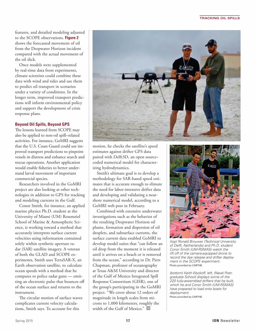
A little over a year later, the SCOPE activity began, with more than 30 re-searchers from 16 universities gathering in Ft. Walton Beach, Florida, in Decem-ber 2013 armed with drifters, dye, and drones to track elusive ocean processes in order to help visualize the three-dimensional movement of Gulf waters.
For the experiment, the researchers deployed 250 GPS-equipped drifters (including 30 biodegradable ones) to track surface waters, using a “release and catch” method to allow repeated use of these specially outfitted devices. SCOPE workers injected a dye both along and outside the surf zone to trace its move-ment through the water column.
The releases of dye and drifters were coordinated with the use of synthetic aperture radar (SAR) images, mi-crostructure and air-sea interaction measurements, observations of frontal
Continued from page 1
TRACKING OIL SPILLS
Figure 2 This image incorporates data on Lagrangian coherent structures or LCS (in red) onto a simulation of the oil slick (in green) following the Deepwater Horizon oil spill. Data from the LCS-core analyses forecasted the subsequent formation and movement of the oil slick (in yellow) some-times referred to as the “tiger tail.” Image by Dr. Maria Josefina Olascoaga. Data acknowledgement to Geoffrey Samuels and the Center for Southeastern Tropical Advanced Remote Sensing (CSTARS) in Miami, Florida
Spring 2015 17 ION Newsletter
TRACKING OIL SPILLS
features, and detailed modeling adjusted to the SCOPE observations. Figure 2 shows the forecasted movement of oil from the Deepwater Horizon incident compared with the actual movement of the oil slick.
Once models were supplemented by real-time data from experiments, climate scientists could combine these data with wind and tides and use them to predict oil transport in scenarios under a variety of conditions. In the longer term, improved transport predic-tions will inform environmental policy and support the development of crisis response plans.
Beyond Oil Spills, Beyond GPSThe lessons learned from SCOPE may also be applied to non-oil spill–related activities. For instance, GoMRI suggests that the U.S. Coast Guard could use im-proved transport predictions to pinpoint vessels in distress and enhance search and rescue operations. Another application would enable fisheries to better under-stand larval movement of important commercial species.
Researchers involved in the GoMRI project are also looking at other tech-nologies in addition to GPS for tracking and modeling currents in the Gulf.
Conor Smith, for instance, an applied marine physics Ph.D. student at the University of Miami (UM) Rosenstiel School of Marine & Atmospheric Sci-ence, is working toward a method that accurately interprets surface current velocities using information contained solely within synthetic aperture ra-dar (SAR) satellite imagery. A veteran of both the GLAD and SCOPE ex-periments, Smith uses TerraSAR-X, an Earth observation satellite, to calculate ocean speeds with a method that he compares to police radar guns — emit-ting an electronic pulse that bounces off of the ocean surface and returns to the instrument.
The circular motion of surface waves complicates current velocity calcula-tions, Smith says. To account for this
motion, he checks the satellite’s speed estimates against drifter GPS data paired with Delft3D, an open source–coded numerical model for character-izing hydrodynamics.
Smith’s ultimate goal is to develop a methodology for SAR-based speed esti-mates that is accurate enough to elimate the need for labor-intensive drifter data and developing and validating a near-shore numerical model, according to a GoMRI web post in February.
Combined with extensive underwater investigations such as the behavior of the resulting Deepwater Horizon oil plume, formation and dispersion of oil droplets, and subsurface currents, the surface current data enabled GoMRI to develop model suites that “can follow an oil drop from the moment it is released until it arrives on a beach or is removed from the ocean,” according to Dr. Piers Chapman, professor of oceanography at Texas A&M University and director of the Gulf of Mexico Integrated Spill Response Consortium (GISR), one of the group’s participating in the GoMRI project. “We cover about 12 orders of magnitude in length scales from mi-crons to 1,000 kilometers, roughly the width of the Gulf of Mexico.” ION
(top) Ronald Brouwer (Technical University of Delft, Netherlands) and Ph.D. student Conor Smith (UM-RSMAS) watch the lift off of the camera-equipped drone to record the dye release and drifter deploy-ment in the SCOPE experiment. Photo provided by CARTHE
(bottom) Keith Wyckoff, left, (Naval Post-graduate School) displays some of the 220 fully-assembled drifters that he built, which he and Conor Smith (UM-RSMAS) have prepared to load onto boats for deployment. Photo provided by CARTHE

ION Newsletter 18 Spring 2015
The 28th International Technical Meeting of the Satellite Division of The Institute of Navigation
ION GNSS+ 2015GNSS + Other Sensors in Today’s Marketplace
September 14 – 18, 2015 Tutorials: Sept. 14 – 15
Tampa Convention Center / Tampa, Florida
SYSTEMS AND APPLICATION TRACKSMass-Market ApplicationsHigh Performance & Safety-Critical ApplicationsSystem Updates, Plans and Policies
And, featuring the popular Indoor Location and Demonstrations
The world’s largest technical meeting and showcase of GNSS technology, products and services.
PEER-REVIEWED TRACKSMultisensor Navigation and ApplicationsAlgorithms and MethodsAdvanced GNSS Technologies

Spring 2015 19 ION Newsletter
North Star Section News
As reported in the ION Winter News-letter, the North Star Section had a
very busy January hosting the Fifth Annual Autonomous Snowplow Competition.
The section would like to acknowledge the hard work of the snowplow competi-tion’s organizing committee and in partic-ular, Suneel Sheikh, who has very capably led this event since its inception in 2009. In addition to Suneel, the committee includes Mark Ahlbrecht, Curt Albrecht, Vibhor Bageshwar, Melissa Fisher, Kristen Gerzina, Tom Jakel, Paul Kline, Jackie Morris, Richard Russell, Kristen Sheikh, Wayne Soehren, and Kevin Sweeney.
More than 75 volunteers made the event possible, from a wide variety of or-ganizations including Honeywell, Alliant Techsystems (now Orbital ATK), ASTER Labs, Lockheed Martin, UTC Aerospace Systems, The Toro Company, University of Minnesota, Target, Innovent Air, John A. Knutson & Company, Emerson, TCF Bank, WSB & Associates, Achievement Rewards for College Scientists (ARCS) Foundation, and Baker Tilly.
The ION North Star section and the Autonomous Snowplow Competition or-ganization committee would like to thank our financial sponsors for their support: the ION Satellite Division, ASTER Labs, Honeywell, Lockheed Martin, Alliant Techsystems (now Orbital ATK), The Toro Company, UTC Aerospace Systems, Deere & Company, U.S. Bancorp, Space Exploration Technologies, Proto Labs, Nuts and Volts Magazine, and Servo Magazine for their ongoing financial support of the competition. The section would also like to thank our Founding Partner, Achievement Rewards for Col-lege Scientists (ARCS) Foundation, for its valuable assistance.
To learn more about the competition and view videos, press coverage, photos and information about the 2015 com-
petition, please visit autosnowplow.com, follow us on Facebook at “Autonomous Snowplow Competition” and on Twitter and Instagram at autosnowplow.
Washington DC Section
Doug Taggart was recently appointed to the role of Chair pro tem of the
DC Section. In response to a non-attribution survey
distributed to 173 ION members in the Virginia, Maryland, and D.C. region, an organizational meeting designed to restart the DC Section was held on Thursday evening, April 2, 2015. Efforts are now focused on finalizing section bylaws and electing a chair, secretary and treasurer.
Member responses to the survey indicated an interest in attending section meetings that provided opportunities for program outreach, social opportunities, student outreach, professional develop-ment, current events and educational opportunities. The current plan is to hold meetings on a quarterly schedule.
A Nomination Committee to orches-trate officer elections has been appointed and elections are expected to be held in mid-May. Mr. Chuck Schue and Mr. Mitch Narins are the Nomination Com-mittee leads.
The next meeting of the Section is scheduled to be held at the U.S. Naval Observatory on the evening of 23 July 2015. Ed Powers has agreed to be the USNO sponsor for the July meeting.
DC Section activity will continue to be posted at: <http://www.ion.org/mem-bership/section-dc.cfm >. ION
ION News and Notes Calendar of Upcoming ION EventsJUNE 2015 22-25: ION JNC 2015, Renaissance Orlando at SeaWorld, Orlando, Florida Contact: The ION Tel: +1 703-366-2723 Web: www.ion.org
AUGUST 201531 August – 10 September 2015ESA/JRC International Summer School on GNSS 2015Hotel Alimara, Barcelona, Spainhttp://congrexprojects.com/2015-events/15m21/registration
SEPTEMBER 2015 14-18: ION GNSS+ 2015, Tampa Convention Center, Tampa, Florida Contact: The ION Tel: +1 703-366-2723 Web: www.ion.org
OCTOBER 2015 20-23: IAIN World Congress 2015, Clarion Congress Hotel Prague, Prague, Czech Republic Contact: IAIN World Congress Tel: +420-284-001-444 Web: www.iain2015.org
JANUARY 201625-28 : ION International Technical Meeting (ITM) & ION Precise Time and Time Interval Meeting (PTTI) 2016, Hyatt Regency Monterey, Monterey, California Contact: ION Tel: +1 703-366-2723 Web: www.ion.org
MAY 20165-8: IEEE/ION Position, Location and Navigation Symposium (PLANS), Hyatt Regency Monterey, Monterey, CaliforniaContact: IONTel: 703-366-2723Web: www.ion.org
ION Newsletter 20 Spring 2015
SMS SMS SMS SMS SMS SMS SMS SMS SMS SMS SMS SMS SMS SMS SMS SMS SMS SMS SMS
Oregon’s Wallowa Moun-tains viewed from Mount Howard. Hurwal Divide is in the front and center, Sacajawea Peak is behind and to the left. Eagle Cap is on the right. Marc Shandro, Wikimedia Commons
HEY WHATS THAT?Name all of the mountain peaks in view
It happens all the time. You’ve pulled over at a scenic overlook or climbed a mountain or sat down on the porch. You look toward the
horizon and say, “What’s the name of that peak over there?”You can pull up a map on your smartphone, but how do you tell what’s
in your field of view? Well, worry no more.The website heywhatsthat.com and its smartphone app shows you all of
the summits visible from where you’re standing (or sitting) anywhere in the world.
The main site computes the horizon and mountain names and other related visualizations, including the surface of the Earth visible from where you’re standing (the visibility cloak or viewshed) and the line of sight profile between you and the distant peaks.
You can view panoramas that someone else has requested and generate your own.
On a smartphone, hit “Show me the view from here.” After a two-minute computation, you’ll see your panorama marked with distant peaks. Scroll from peak to peak with the arrows and use the buttons or menu to see the List and Details views. Go back and try the Surprise Me menu entry to see some particularly nice pre-computed results.
HeyWhatsThat also features an eclipse page, beloved of the Google Earth blog. It features two panes, one showing the expected path of the eclipse on the earth and the other, using Google Sky, shows the current position and path of the Moon across the sky.www.heywhatsthat.com
Spring 2015 21 ION Newsletter
TO THE RESCUECan GNSS, UAVs, and Big Data Save the Elephants?
The half a million elephants and the 20,000 rhinos left in the African
wild may actually go away forever. But they’re not going down without a fight — and GNSS may help.
United Nations numbers show that the illegal wildlife trade is amazingly lucra-tive, with ivory tusks and rhino horns commanding large profits in a $213 bil-lion black market.
But unmanned aerial vehicles (UAVs) equipped with infrared cam-eras and GPS can locate animals and poachers operating in darkness and let rangers know where and when to go find them.
In South Africa, the Lindbergh Foun-dation-funded Air Shepherd nonprofit developed and tested a pilot program in
state parks. They claim, “Where we fly, poaching stops. Completely.”
They worked with University of Mary-land professor Thomas Snitch who devel-oped software to guide the UAVs to spe-cific locations by high-resolution satellite imagery, analysis of past events, terrain, population distribution, radio collars, and other information that results in predict-able patterns of animal behavior.
Snitch said in a Slate interview, “We know, with near 90 percent certainty, where rhinos are likely to be on a particu-lar night between 6:30 and 8:00, prime time for killings. . . . the model tells us precisely where we should deploy our rangers on any specific night.”
The consumer drones they use can be launched by hand, carry two pounds
of cameras for use in the light and the darkness, and fly for up to two hours on a charge.
The problem, said a Duke university lab director involved in a similar project, is that “the poachers have drones of their own. That’s the technology war we are seeing right now.”
SMS SMS SMS SMS SMS SMS SMS SMS SMS SMS SMS SMS SMS SMS SMS SMS SMS SMS SMS
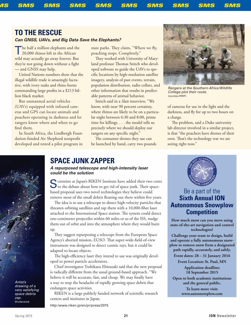
Rangers at the Southern Africa Wildlife College plot their route.(courtesy WWF)
Be a part of the Sixth Annual ION
Autonomous Snowplow Competition
How much snow can you move using state-of-the-art navigation and control
technologies?Challenge your team to design, build
and operate a fully autonomous snow-plow to remove snow from a designated
path rapidly, accurately, and safely.Event dates: 28 – 31 January 2016
Event Location: St. Paul, MNApplication deadline: 18 September 2015
Open to both academic institutions and the general public.
To learn more visit: www.autosnowplow.com
SPACE JUNK ZAPPERA repurposed telescope and high-intensity laser could be the solution
Scientists at Japan’s RIKEN Institute have added their two cents to the debate about how to get rid of space junk. Their space-
based proposal uses two novel technologies they believe could remove most of the small debris floating out there within five years.
The idea is to use a telescope to detect high-velocity particles that threaten orbiting satellites and zap them with a 10,000-fiber laser attached to the International Space station. The system could detect one-centimeter projectiles within 60 miles or so of the ISS, nudge them out of orbit and into the atmosphere where they would burn up.
They suggest repurposing a telescope from the European Space Agency’s aborted mission, EUSO. That super-wide-field-of-view instrument was designed to detect cosmic rays, but it could be adapted to locate objects.
The high-efficiency laser they intend to use was originally devel-oped to power particle accelerators.
Chief investigator Toshikazu Ebisuzaki said that the new proposal is radically different from the usual ground-based approach. “We believe it will be accurate, fast, and cheap. We may finally have a way to stop the headache of rapidly growing space debris that endangers space activities.
RIKEN is a large publicly funded network of scientific research centers and institutes in Japan.http:/www.riken.jp/en/pr/press/2015
Artist’s drawing of a very satisfying space debris zap.Shutterstock

ION Newsletter 22 Spring 2015
GNSS Program Updates
News from Systems Around the WorldIt’s Spring, and GNSS Is in the Air.
It was a busy spring for the world’s GNSS systems. Within one six-day
stretch — March 25–30 — five naviga-tion satellites were placed into orbit: a GPS Block IIF, two full operational capability (FOC) Galileo spacecraft, a new-generation BeiDou satellite, and an Indian Regional Navigation Satellite System (IRNSS) space vehicle.
GPSApril 27 marked the 20th anniversary of the U.S. Air Force Space Command’s declaration of full operational capability (FOC) for the GPS constellation. FOC meant that the system had 24 opera-tional satellites (at the time, Block II/IIA spacecraft) in their assigned orbital slots that provided both the military Precise Positioning Service (PPS) performance standard and the civil Standard Position-ing Service (SPS).
Also in April, Lockheed Martin com-pleted final integration of the first GPS III satellite, bringing together the system module — which includes the naviga-tion payload that performs the primary positioning, navigation and timing mis-sion — the functional bus containing the electronics that manage all satellite operations, and the propulsion core that enables the satellite to maneuver for operations on orbit.
As outlined the ION Pacific PNT meeting by Mr. David Turner, deputy director of the U.S. Department of State’s Office of Space and Advanced Technology, the Global Positioning System continues to sustain a robust operational constel-lation that made up of 3 GPS Block IIA satellites, 12 IIRs, 7 IIR-Ms (adding L2C, L1M, L2M signals) and 9 GPS IIFs (in-cluding new L5 signal) with 8 additional satellites in residual or test status.
The most recent launch — of the ninth IIF space vehicle (SV) — came on March 25. Another two GPS IIF launches are planned during 2015.
System performance continues to improve as new satellites replace older ones, with average user range error for the civil Standard Positioning Service (SPS) signal in space declining to 0.7 meters in 2014 — a steady improvement from 1.6 meters in 2001. Modifications of the bat-tery charge control have extended GPS IIR and IIR-M satellite life by one to two years, Turner added.
BeiDouAnother Pacific PNT 2015 presentation prepared by Weilin Song, of the China Satellite Navigation Office (CSNO), and Jun Shen, CSNO International Coopera-tion Center, revealed details of the next phase of China’s BeiDou Satellite System.
Deployment of a new-generation satel-lites has begun with a successful launch on March 30. Three or four more test satellites will go up this year to carry out validation of a new types of navigation signals and demonstrate inter-satellite links. The spacecraft launch in March was the first BDS satellite developed by Chinese Academy of Sciences, which took advantage of a new, independent upper stage, YZ-1, on the Long March-3 launch vehicle.
GalileoEurope finally managed to get a pair of full operational capability (FOC) Galileo satellites into the correct orbits with a launch on March 27.
The constellation now has eight satel-lites in orbit, including four in-orbit validation (IOV) satellites launched in 2011 and 2012 and the first two FOC spacecraft placed into an anomalous orbit last August. Additional launches of two
satellites each are tentatively scheduled for September and December.
As re-worked by the European Com-mission, the program goal is to deliver, by 2016, a package of Initial Services, in-cluding a free Open Service, an encrypted Public Regulated Service, and a Search And Rescue function to be transferred to the responsibility of the European GNSS Agency, GSA.
GLONASSThe first GLONASS-K2 spacecraft launch will occur in 2018, according to Nicholas Testoyedov, CEO of the satellite manufacturer Reshetnev Infor-mation Satellite Systems. The satellite willl broadcast the new code division (CDMA) signals. Next launch for a cur-rent-generation GLONASS-M satellite is planned from Plesetsk in September.
IRNSSThe fourth satellite of Indian Regional Navigation Satellite System, IRNSS-1D, was launched into geosynchronous orbit (GSO) on March 28 on board the Polar Satellite Launch Vehicle (PSLV-C27).
Seven satellites will comprise the IRNSS constellation being developed by the Indian Space Research Organization (ISRO) to provide navigational services. IRNSS will help augment the satellite-based navigation system of India, which is currently under development and will provide navigation, tracking, and map-ping services to the South Asia region.
IRNSS-1A, 1B and 1C, the first three satellites of the constellation, were suc-cessfully launched by PSLV on July 02, 2013, April 04, 2014, and October 16, 2014, respectively. ISRO expects to have the entire IRNSS constellation completed by 2016. ION

Spring 2015 23 ION Newsletter
The phenomenon of technology creat-ing possibilities faster than govern-
ments can regulate their safe use has become a hallmark of modernization.
Perhaps the most recent example has appeared in the matter of unmanned vehicles and aircraft operating in public environments. Automakers are load-ing sensors and software onto new models that, in effect, create ever more autonomous capabilities in the vehicles: lane-keeping, steering assist, automatic braking, and so.
A recent New York Times article review-ing the 2015 New York Auto Show, observed, “The path to fully autonomous driving will still take years to reach con-sumers, but car manufacturers demon-strated this week that they are now able to offer buyers several levels of so-called active safety features — in which the car takes over driving in certain instances. And they plan to introduce even more advanced semiautonomous capabilities in the coming months.”
In the air, unmanned aerial vehicles (UAVs) are being proposed or used for a multitude of applications, from deliver-ing packages to mapping powerlines to environmental surveillance.
In both domains, positioning and navigation functionality is well estab-lished, using such technologies as GNSS, inertial measurement units, communica-tion infrastructure, digital maps, video, and lasers.
Commercial pressure to permit greater flexibility in the use of UAVs is augment-ed by the presence of well-established programs for implementing guidance, navigation, and control(GNC-)–related operations: automatic dependent surveil-lance, sense and avoid, automated preci-sion landing, and so forth. Indeed, the Federal Aviation Administration (FAA) NextGen program — however much it’s behind schedule and over budget — is al-ready on course to transform the nation’s air traffic management.
As for “smart cars,” in-vehicle naviga-tion-related technologies that were first
introduced 20 years ago have become so taken for granted (and overtaken by smart-phone capabilities) that they are no longer top of mind among new car buyers.
A recent J. D. Power “U.S. Tech Choice Study” showed navigation-related OEM technologies to be a low preference of consumers across all vehicle price seg-ments. Part of this decline in interest in OEM navigation systems may stem from growth in smartphone-based telematics location-based service (LBS) apps. Mobile phone purchase cycles — and associated technology and user interface develop-ment — are much shorter than automo-tive electronics system design, lowering the risks and costs of innovation while increasing flexibility and timeliness of new features.
All these technological advances, however, are outstripping the ability of regulatory agencies to create appropriate rules of engagement to ensure their safe introduction and use.
As the New York Times said in a May 3 article entitled “Hands-Free Cars Take Wheel, and Law Isn’t Stopping Them,” “Technology has sprinted ahead so fast that lawmakers and regulators are scambling to catch up with features like hands-free driving that are now months away, rather than years.”
In February the FAA — caught between a congressional mandate to facili-tate the introduction of safely regulated unmanned aerial systems (UAS) and industry pressure to do so quickly — re-leased a proposed set of regulations would pave the way for small UAS — those un-der 55 pounds — to enter the mainstream of U.S. civil aviation. The rule, according to an FAA statement, “would allow rou-tine use of small UAS in today’s aviation system, and is flexible enough to accom-modate future technological innovations.”
The following month the agency introduced a “summary grant” process designed to speed up Section 333 exemp-tion approvals for many commercial UAS operators. Section 333 is the part of the 2012 FAA reauthorization law that lets
the Secretary of Transportation determine if certain low-risk UAS operations can be authorized prior to finalizing the small UAS proposed rule published in February.
As Jim Williams, manager of the FAA UAS Integration Office, pointed out in a presentation to the Remotely Piloted Aircraft Systems (RPAS) Symposium held by the International Civil Aviation Orga-nization (ICAO) in Montreal, Canada, approvals of exemptions to Section 333 are also growing rapidly. In 2013, 407 exemptions — known as certificates of waiver or authorization (COAs) — were granted, and in 2014, 609. In the first two and a half months of this year, the FAA had already issued 165 COAs.
In the automotive area, however, the regulatory environment is much more ambiguous for autonomous driving. Reportedly, only the state of New York specifically mandates that drivers have to have at least one hand on the wheel. The absence of such laws elsewhere probably stem from the fact that until recently no other navigation options existed for cars except manual control.
In the absence of regulations, automo-bile manufacturers are pushing ahead. Anna Schneider, vice-president for gov-ernment relations at Volkswagen, which ill introduce an Audi next year with the ability to navigate through traffic hands-free, told the New York Times, “Where it’s not expressly prohibited, we would argue it’s allowed.”
The newspaper also quoted Dan Flores, a General Motors spokesman, as saying, “We don’t need any change in legislation to put Super Cruise [a no-hands feature com-ing in the 2016 Cadillac] on the road.”
Even federal regulators acknowledge the legal void. “If someone wants to sell a totally automated vehicle today, you could probably get a court to decide there’s nothing the National Highway Traffic Safety Administration [NHTSA], can do about that until it presents an unreasonable risk to safety,” NHTSA spokesman Gordon Trowbridge admitted to the Times. ION
Unmanned Vehicles, Aircraft
Navigation Technology Versus Regulation

THE INSTITUTE OF NAVIGATION8551 Rixlew Lane, Suite 360Manassas, VA 20109-3701
Nonprofit Org.U.S. Postage
PAIDPermit No. 425 Southern, MD
5Classified Session will be held June 25
at Shades of Green on Walt Disney World Resort
June 22-25, 2015Tutorials: June 22
Show Dates: June 23-24, 2015Renaissance Orlando at SeaWorld
Orlando Florida
Sponsored by:The Military Division of
The Institute of Navigation (ION)
Register Now!
“Military Navigation Technology: The Foundation for Military Ops”
www.ion.org/jnc