Embed Size (px)
Citation preview
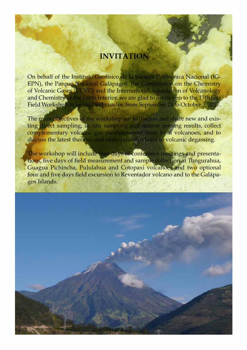
INVITATION
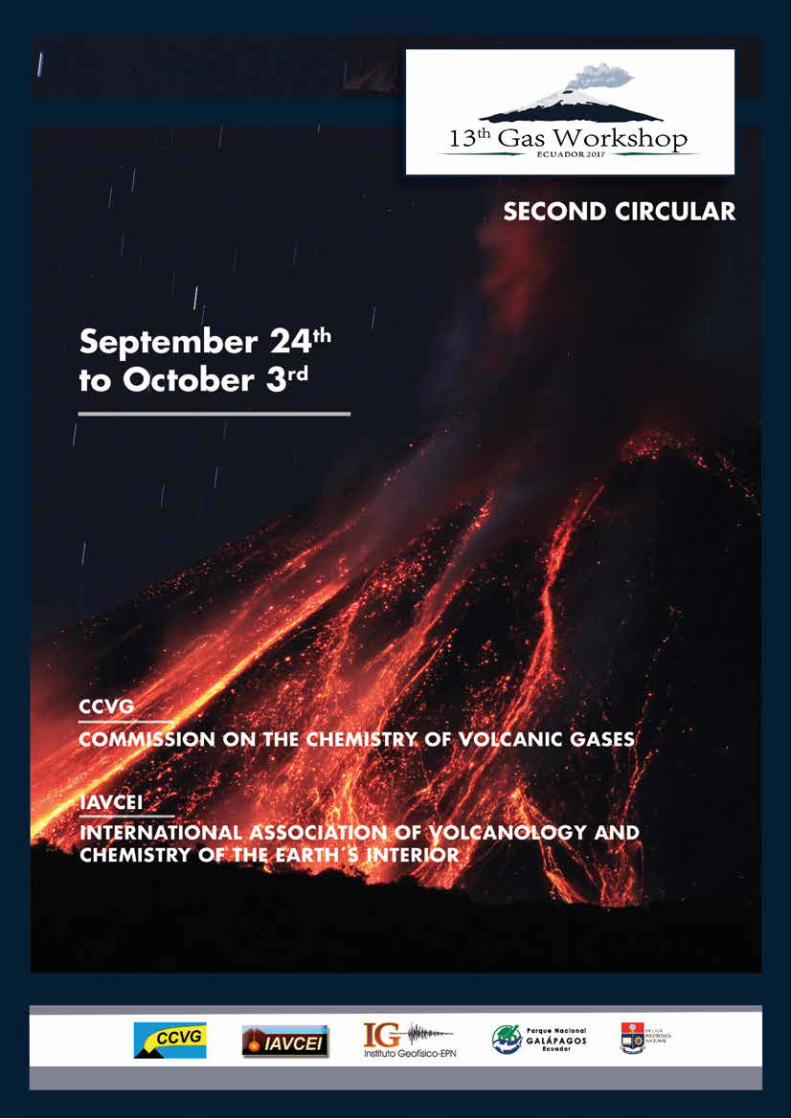
On behalf of the Instituto Geofísico de la Escuela Politécnica Nacional (IG- EPN), the Parque Nacional Galápagos, the Commission on the Chemistry of Volcanic Gases (CCVG) and the International Association of Volcanology and Chemistry of the Earth Interior, we are glad to invite you to the 13th Gas Field Workshop to be held in Ecuador, from September 24 to October 3, 2017.
The main objectives of the workshop are to discuss and share new and exis- ting direct sampling, in situ sampling and remote sensing results, collect complementary volcanic gas measurements from local volcanoes, and to discuss the latest theories and observations related to volcanic degassing.
The workshop will include four days of conference meetings and presenta-tions, five days of field measurement and sample collection at Tungurahua, Guagua Pichincha, Pululahua and Cotopaxi volcanoes and two optional four and five days field excursion to Reventador volcano and to the Galápa-gos Islands.
Scientific Programme
The program will include a 4-day scientific meeting focused on geochemistry of magmatic gases and fluxes from volcanoes, followed by a 5-day field excursion to allow participants to acquire plume measurements, diffuse soil flux measurements and direct fumarole and water samples from local volcanoes. Details of the scientific program and field campaign are outlined below.
Conference:
1. New developments in direct, in situ, remote, and diffuse volcanic gas and aerosol sampling/measurement tech-niques, including but not limited to advancements related to measurement accuracy and precision, acquisition, automation and analysis.
2. Geochemical observations and interpretations of volcanic and hydrothermal systems.
3. The effect of volcanic plumes on atmospheric chemistry, natural hazards and environmental and human health.
4. Modeling of volcanic degassing processes.
5. Integrating volcanic gas observations with complementary datasets to elucidate volcanic processes
Scientific CommitteePatrick Allard Ryu KazahayaSantiago Arellano Taryn Lopez Nicole Bobrowski Agnes MarzotMike Burton Yuri TaranMaarten de Moor Franco TassiTobias Fischer Fatima Viveiros
Field Campaign:
1. Remote plume measurements (Tungurahua and Cotopaxi).2. Measurements of soil degassing (Pululahua).3. Direct sampling of fluids emitted from thermal springs and fumaroles (Tungurahua and Pichincha)
CCVG-IAVCEI 13th GAS WORKSHOP
CCVG-IAVCEI 13th GAS WORKSHOP
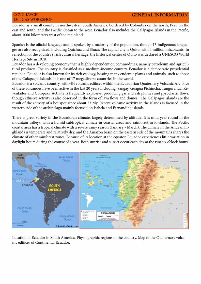
Ecuador is a small county in northwestern South America, bordered by Colombia on the north, Peru on the east and south, and the Pacific Ocean to the west. Ecuador also includes the Galápagos Islands in the Pacific, about 1000 kilometers west of the mainland.
Spanish is the official language and is spoken by a majority of the population, though 13 indigenous langua-ges are also recognized, including Quichua and Shuar. The capital city is Quito, with 4 million inhabitants. In reflection of the country’s rich cultural heritage, the historical center of Quito was declared a UNESCO World Heritage Site in 1978.Ecuador has a developing economy that is highly dependent on commodities, namely petroleum and agricul-tural products. The country is classified as a medium-income country. Ecuador is a democratic presidential republic. Ecuador is also known for its rich ecology, hosting many endemic plants and animals, such as those of the Galápagos Islands. It is one of 17 megadiverse countries in the world.Ecuador is a volcanic country, with~84 volcanic edifices within the Ecuadorian Quaternary Volcanic Arc. Five of these volcanoes have been active in the last 20 years including: Sangay, Guagua Pichincha, Tungurahua, Re-ventador and Cotopaxi. Activity is frequently explosive, producing gas and ash plumes and pyroclastic flows, though effusive activity is also observed in the form of lava flows and domes. The Galápagos islands are the result of the activity of a hot spot since about 23 My. Recent volcanic activity in the islands is focused in the western side of the archipelago mainly focused on Isabela and Fernandina islands.
There is great variety in the Ecuadoran climate, largely determined by altitude. It is mild year-round in the mountain valleys, with a humid subtropical climate in coastal areas and rainforest in lowlands. The Pacific coastal area has a tropical climate with a severe rainy season (January - March). The climate in the Andean hi-ghlands is temperate and relatively dry, and the Amazon basin on the eastern side of the mountains shares the climate of other rainforest zones. Because of its location at the equator, Ecuador experiences little variation in daylight hours during the course of a year. Both sunrise and sunset occur each day at the two six o’clock hours.
GENERAL INFORMATION
Location of Ecuador in South América. Physiographic regions of the country. Map of the Quaternary volca-nic edifices of Continental Ecuador.
CCVG-IAVCEI 13th GAS WORKSHOP
79° W1° N
0°
1° S
2° S
78° W 77° W
Guaranda
Riobamba
Puyo
Ambato
Latacunga
Tena
Baeza
Quito
Cayambe
Otavalo
Ibarra
Tulcán
Santo Domingode Los Tsáchilas
0 5025km
Colombia
Ciudades principales
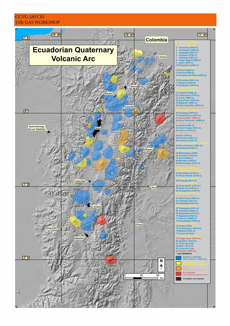
1 Cerro Negro* (4465 m)2 Chiles* (4707 m)3 Potrerillos (4165 m)4 Chulamuez (3566 m)5 Chalpatán (3624 m)6 Horqueta (3700 m)7 Chiltazón (3967 m)8 Virgen Negra (3658 m)9 Iguán (3876 m)10 Chaquilulo (3649 m)11 Soche (3955 m)12 Pilavo (4224 m)13 Parulo (3300 m)14 Yanaurcu de Piñán (4535 m)15 Chachimbiro* (4105 m)16 Pulumbura (4214 m)17 Mangus (3944 m)18 Cotacachi* (4944 m)19 Cuicocha* (3377 m)20 Imbabura* (4621 m)21 Cubilche (3828 m)22 Cushnirumi (3776 m)23 Cusín (3989 m)24 Fuya-Fuya* (4279 m)25 Mojanda* (4263 m)26 Viejo Cayambe* (4815 m)27 Nevado Cayambe* (5790 m)28 Pululahua* (3356 m)29 Casitagua (3519 m)30 Pambamarca (4075 m)31 Reventador* (3562 m)32 Rucu Pichincha* (4696 m)33 Guagua Pichincha* (4776 m)34 Izambi (4356 m)35 Cerro Puntas (4550 m)36 Coturco (3575 m)37 Chacana* (4493 m)38 Ilaló (3188 m)39 Carcacha (3813 m)40 Yanaurcu (3127 m)41 Atacazo-Ninahuilca* (4455 m)42 Pan de Azúcar (3482 m)43 Pasochoa (4199 m)44 Antisana* (5758 m)45 Machángara (3460)46 Corazón* (4782 m)47 Aliso (4260 m)48 Bermejo (2939 m)49 Sincholagua (4873 m)50 Sumaco* (3732 m)51 El Dorado (2785 m)52 Domos Huevos de Chivo53 Rumiñahui (4722 m)54 Almas Santas (3745 m)55 Pumayacu (2950 m)56 Cosanga (4011 m)57 Huañuña (4251 m)58 Iliniza Norte* (5105 m)59 Santa Cruz (3978 m)60 Chaupiloma (4196 m)61 Iliniza Sur* (5245 m)62 Cotopaxi* (5897 m)63 Volcán Azul (3069 m)64 Chalupas (4214 m)65 Quilindaña (4876 m)66 Quilotoa* (3915 m)67 Putzalagua (3512 m)68 Chinibano (4200 m)69 Angahuana (4125 m)70 Sagoatoa (4169 m)71 Pilisurco (4508 m)72 Huicutambo (3534 m)73 Puñalica* (3988)74 Huisla (3763)75 Carihuairazo* (5018 m)76 Mulmul (3878 m)77 Conos de Puyo78 Chimborazo* (6268 m)79 Tungurahua* (5023 m)80 Igualata* (4430 m)81 Conos de Calpi82 Altar* (5319 m)83 Conos de Licto84 Sangay* (5260 m)* con monitoreo
Potencialmente activo(última erupción < 10000 años)
Extinto o dormido(última erupción > 10000 años)
Activo(última erupción < 500 años)
En erupción(con actividad eruptiva en 2011)
N
44
57
3 45
6
7
8
910
12
1314
1617
18
21
2223
24
25
26
2729
3031
32
3334
35
3637
3839 40
4243
495346
47
60
54
5859
6264
65
6867
69
7271
70
75
80
74
76
79
82
81
83
84
77
50
63
56
1
2
11
15
19
20
28
41
61
66
73
78
55
5148
45
52
Ecuadorian QuaternaryVolcanic Arc
CCVG-IAVCEI 13th GAS WORKSHOP
AGENDA
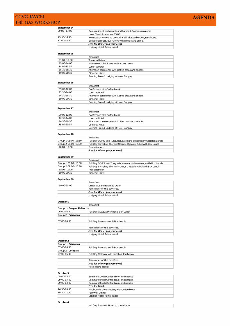
September 24
09:00- 17:00 Registration of participants and handout Congress material
Hotel Check In starts at 13:00
15:30-16:30 Ice Breaker- Welcome cocktail and invitation by Congress hosts.
17:00-18:30 Ecuadorian Party bus “Chiva” with music and drinks.
Lodging Hotel Reina Isabel
September 25
Breakfast
09:00- 12:00 Travel to Baños
13:00-14:00 Free time to check in or walk around town
14:00-15:30 Lunch at Hotel
15:30-18:30 Afternoon conference with Coffee break and snacks
19:00-20:30 Dinner at Hotel
Evening Free & Lodging at Hotel Sangay
September 26
Breakfast
09:00-12:00 Conference with Coffee break
12:30-14:00 Lunch at Hotel
14:30-18:30 Afternoon conference with Coffee break and snacks
19:00-20:30 Dinner at Hotel
Evening Free & Lodging at Hotel Sangay
September 27
Breakfast
09:00-12:00 Conference with Coffee break
12:30-14:00 Lunch at Hotel
14:30-18:30 Afternoon conference with Coffee break and snacks
19:00-20:30 Dinner at Hotel
Evening Free & Lodging at Hotel Sangay
September 28
Breakfast
Group 1 09:00- 16:30 Full Day DOAS and Tungurahua volcano observatory with Box Lunch
Group 2 09:00- 16:30 Full Day Sampling Thermal Springs Casa del Arbol with Box Lunch
17:00- 19:00 Free afternoon
September 29
Breakfast
Group 1 09:00- 16:30 Full Day DOAS and Tungurahua volcano observatory with Box Lunch
Group 2 09:00- 16:30 Full Day Sampling Thermal Springs Casa del Arbol with Box Lunch
17:00- 19:00 Free afternoon
19:00-20:30 Dinner at Hotel
September 30
Breakfast
10:00-13:00 Check Out and return to Quito
Remainder of the day Free.
Lodging Hotel Reina Isabel
October 1
Breakfast
06:00-16:30 Full Day Guagua Pichincha Box Lunch
07:00-16:30 Full Day Pululahua with Box Lunch
Remainder of the day Free.
Lodging Hotel Reina Isabel
October 2
07:00-16:30 Full Day Pululahua with Box Lunch
07:00-16:30 Full Day Cotopaxi with Lunch at Tambopaxi
Remainder of the day Free.
Hotel Reina Isabel
October 3
09:00-13:00 Seminar #1 with Coffee break and snacks
09:00-13:00 Seminar #2 with Coffee break and snacks
09:00-13:00 Seminar #3 with Coffee break and snacks
Free for Lunch
16:30-18:30 Final Conference Meeting with Coffee break
19:30-21:30 Farewell Dinner
Lodging Hotel Reina Isabel
October 4
All Day Transfers Hotel to the Airport
Free for Dinner (on your own)
Free for Dinner (on your own)
Free for Dinner (on your own)
Group 1- Guagua Pichincha
Group 2- Pululahua
Free for Dinner (on your own)
Group 1- Pululahua
Group 2- Cotopaxi
Free for Dinner (on your own)
CCVG-IAVCEI 13th GAS WORKSHOP
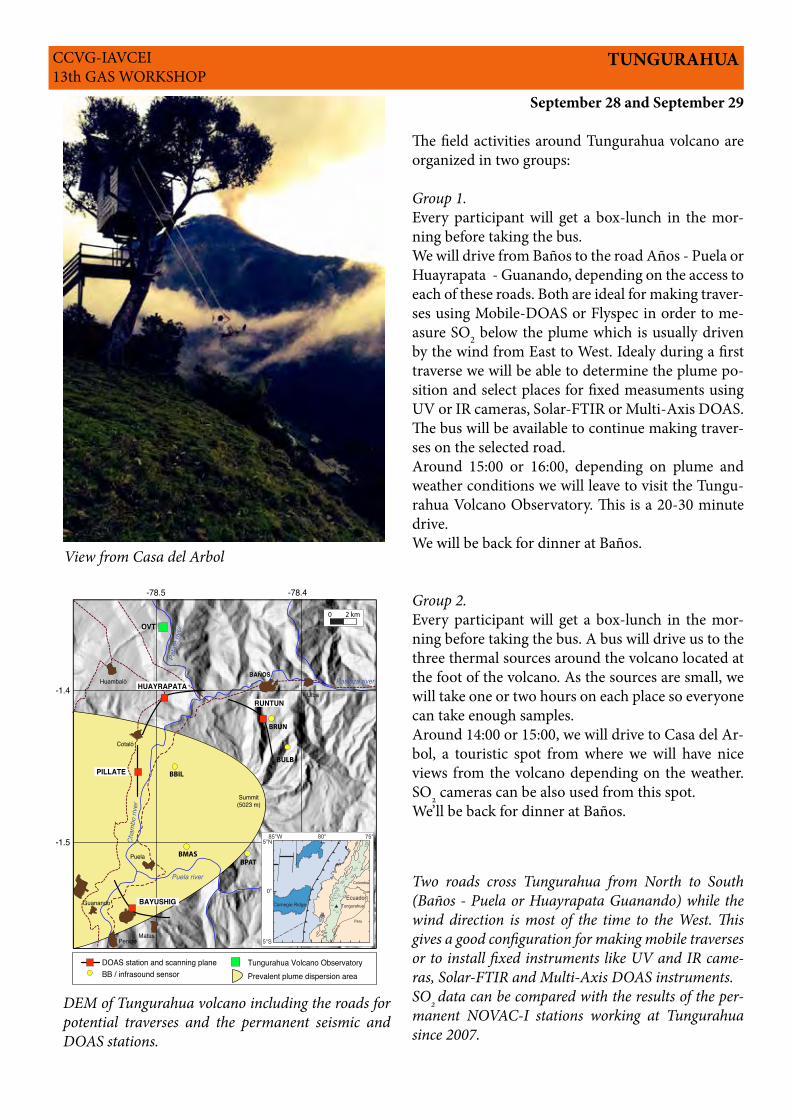
TUNGURAHUA
September 28 and September 29
The field activities around Tungurahua volcano are organized in two groups:
Group 1.Every participant will get a box-lunch in the mor-ning before taking the bus.We will drive from Baños to the road Años - Puela or Huayrapata - Guanando, depending on the access to each of these roads. Both are ideal for making traver-ses using Mobile-DOAS or Flyspec in order to me-asure SO2 below the plume which is usually driven by the wind from East to West. Idealy during a first traverse we will be able to determine the plume po-sition and select places for fixed measuments using UV or IR cameras, Solar-FTIR or Multi-Axis DOAS. The bus will be available to continue making traver-ses on the selected road.Around 15:00 or 16:00, depending on plume and weather conditions we will leave to visit the Tungu-rahua Volcano Observatory. This is a 20-30 minute drive.We will be back for dinner at Baños.
Group 2.Every participant will get a box-lunch in the mor-ning before taking the bus. A bus will drive us to the three thermal sources around the volcano located at the foot of the volcano. As the sources are small, we will take one or two hours on each place so everyone can take enough samples.Around 14:00 or 15:00, we will drive to Casa del Ar-bol, a touristic spot from where we will have nice views from the volcano depending on the weather. SO2 cameras can be also used from this spot.We’ll be back for dinner at Baños.
BAYUSHIG
RUNTUN
HUAYRAPATA
PILLATE
Penipe
Huambaló
Guanando
Puela
Cotaló
Matus
BAÑOS
Ulba
DOAS station and scanning plane
-78.5 -78.4
-1.4
-1.5
Tungurahua Volcano Observatory
Pata
te ri
ver
Pastaza river
Cha
mbo
rive
r
OVT
Summit(5023 m)
Puela river
Prevalent plume dispersion area
0 2 km
BULB
BBIL
BMASBPAT
BRUN
BB / infrasound sensor
9835
80°85°W
5°S
0°
5°N
Ecuador
Peru
Colombia
75°
Carnegie Ridge Tungurahua
Two roads cross Tungurahua from North to South (Baños - Puela or Huayrapata Guanando) while the wind direction is most of the time to the West. This gives a good configuration for making mobile traverses or to install fixed instruments like UV and IR came-ras, Solar-FTIR and Multi-Axis DOAS instruments.SO2 data can be compared with the results of the per-manent NOVAC-I stations working at Tungurahua since 2007.
DEM of Tungurahua volcano including the roads for potential traverses and the permanent seismic and DOAS stations.
View from Casa del Arbol
CCVG-IAVCEI 13th GAS WORKSHOP
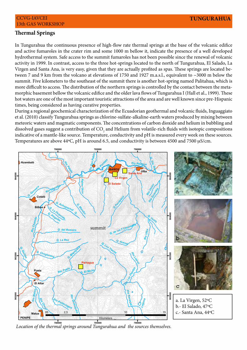
Thermal Springs
In Tungurahua the continuous presence of high-flow rate thermal springs at the base of the volcanic edifice and active fumaroles in the crater rim and some 1000 m bellow it, indicate the presence of a well developed hydrothermal system. Safe access to the summit fumaroles has not been possible since the renewal of volcanic activity in 1999. In contrast, access to the three hot-springs located to the north of Tungurahua, El Salado, La Virgen and Santa Ana, is very easy, given that they are actually profited as spas. These springs are located be-tween 7 and 9 km from the volcano at elevations of 1750 and 1927 m.a.s.l., equivalent to ~3000 m below the summit. Five kilometers to the southeast of the summit there is another hot-spring named Palitahua, which is more difficult to access. The distribution of the northern springs is controlled by the contact between the meta-morphic basement bellow the volcanic edifice and the older lava flows of Tungurahua I (Hall et al., 1999). These hot waters are one of the most important touristic attractions of the area and are well known since pre-Hispanic times, being considered as having curative properties.During a regional geochemical characterization of the Ecuadorian geothermal and volcanic fluids, Inguaggiato et al. (2010) classify Tungurahua springs as chlorine-sulfate-alkaline-earth waters produced by mixing between meteoric waters and magmatic components. The concentrations of carbon dioxide and helium in bubbling and dissolved gases suggest a contribution of CO2 and Helium from volatile-rich fluids with isotopic compositions indicative of a mantle-like source. Temperature, conductivity and pH is measured every week on these sources. Temperatures are above 44ºC, pH is around 6.5, and conductivity is between 4500 and 7500 mS/cm.
TUNGURAHUA
!
! !
!
Q.
Rio N
aranjal
Rio
Cham
bo
Q. La Rea
Rio Chasi
Rio Puela
Q. Choglantus
Rio
Mat
us
Q. del Romero
Q. Los Tiacos
Q. El Niche
Rio
Las
Flau
tas
Rio Palitictagua
Rio Quinaquiro
Rio Laurel
Q. Pingullo
Q. Guilles Q. Map
ayac
u
Q. La Pirámide
Lagu
naR
io U
lba
Rio Pastaza
Rio Chambo
Rio
Vazc
ún
Q. Mandur
Q. Arenal
Q. Ques
era
Q Puc
ayac
u
Rio
Guam
ba
Q. Palm
a Urcu
Q. Achupashal
Q. Uvilla
Rio
Unió
n
Q. Sta. RosaR
io S
an P
ablo
Q. de las 7 Chorreras
Rio Patate Rio Pastaz
a
UlbaBAÑOS
Cotaló
Huambaló
Matus
Puela
Bilbao
El Altar
PENIPE
El Salado
Santa Ana
Palitagua
La Virgen
780000
780000
785000
785000
790000
790000
9830
00
9830
00
9835
00
9835
00
9840
00
9840
00
9845
00
9845
00
05 10 152,5
Kilometers
a.- La Virgenb.- Santa Anac.- El Salado
a
b
c
summit
a. La Virgen, 52ºCb.- El Salado, 47ºCc.- Santa Ana, 44ºC
Location of the thermal springs around Tungurahua and the sources themselves.
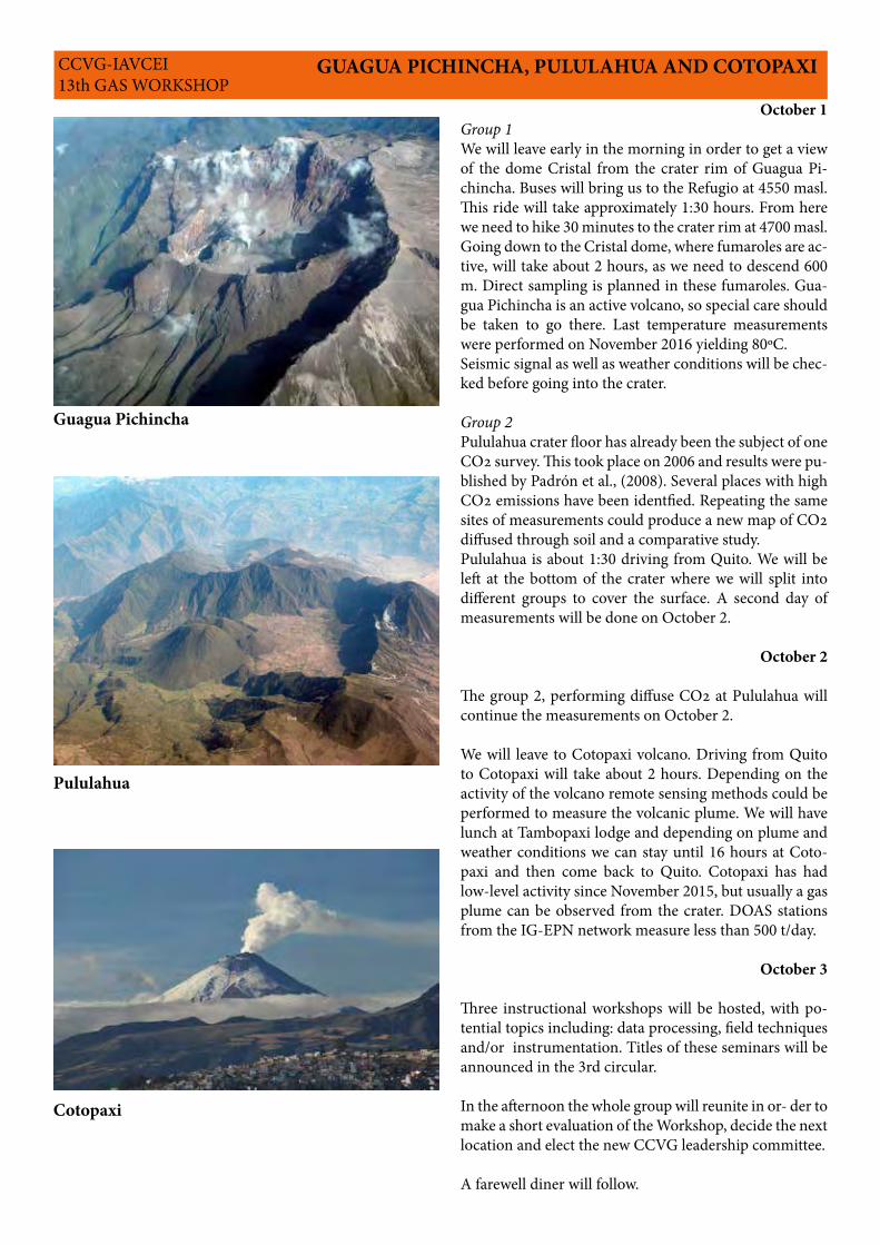
GUAGUA PICHINCHA, PULULAHUA AND COTOPAXICCVG-IAVCEI 13th GAS WORKSHOP
October 1Group 1We will leave early in the morning in order to get a view of the dome Cristal from the crater rim of Guagua Pi-chincha. Buses will bring us to the Refugio at 4550 masl. This ride will take approximately 1:30 hours. From here we need to hike 30 minutes to the crater rim at 4700 masl. Going down to the Cristal dome, where fumaroles are ac-tive, will take about 2 hours, as we need to descend 600 m. Direct sampling is planned in these fumaroles. Gua-gua Pichincha is an active volcano, so special care should be taken to go there. Last temperature measurements were performed on November 2016 yielding 80ºC.Seismic signal as well as weather conditions will be chec-ked before going into the crater.
Group 2Pululahua crater floor has already been the subject of one CO2 survey. This took place on 2006 and results were pu-blished by Padrón et al., (2008). Several places with high CO2 emissions have been identfied. Repeating the same sites of measurements could produce a new map of CO2 diffused through soil and a comparative study. Pululahua is about 1:30 driving from Quito. We will be left at the bottom of the crater where we will split into different groups to cover the surface. A second day of measurements will be done on October 2.
October 2
The group 2, performing diffuse CO2 at Pululahua will continue the measurements on October 2.
We will leave to Cotopaxi volcano. Driving from Quito to Cotopaxi will take about 2 hours. Depending on the activity of the volcano remote sensing methods could be performed to measure the volcanic plume. We will have lunch at Tambopaxi lodge and depending on plume and weather conditions we can stay until 16 hours at Coto-paxi and then come back to Quito. Cotopaxi has had low-level activity since November 2015, but usually a gas plume can be observed from the crater. DOAS stations from the IG-EPN network measure less than 500 t/day.
October 3
Three instructional workshops will be hosted, with po-tential topics including: data processing, field techniques and/or instrumentation. Titles of these seminars will be announced in the 3rd circular.
In the afternoon the whole group will reunite in or- der to make a short evaluation of the Workshop, decide the next location and elect the new CCVG leadership committee.
A farewell diner will follow.
Guagua Pichincha
Pululahua
Cotopaxi
CCVG-IAVCEI 13th GAS WORKSHOP
Proposed Schedule for Pre-Conference Field Trip
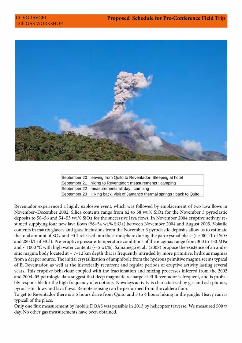
Reventador experienced a highly explosive event, which was followed by emplacement of two lava flows in November–December 2002. Silica contents range from 62 to 58 wt.% SiO2 for the November 3 pyroclastic deposits to 58–56 and 54–53 wt.% SiO2 for the successive lava flows. In November 2004 eruptive activity re-sumed supplying four new lava flows (56–54 wt.% SiO2) between November 2004 and August 2005. Volatile contents in matrix glasses and glass inclusions from the November 3 pyroclastic deposits allow us to estimate the total amount of SO2 and HCl released into the atmosphere during the paroxysmal phase (i.e. 80 kT of SO2 and 280 kT of HCl). Pre-eruptive pressure-temperature conditions of the magmas range from 300 to 150 MPa and ~ 1000 °C with high water contents (~ 5 wt.%). Samaniego et al., (2008) propose the existence of an ande-sitic magma body located at ~ 7–12 km depth that is frequently intruded by more primitive, hydrous magmas from a deeper source. The initial crystallization of amphibole from the hydrous primitive magma seems typical of El Reventador, as well as the historically recurrent and regular periods of eruptive activity lasting several years. This eruptive behaviour coupled with the fractionation and mixing processes inferred from the 2002 and 2004–05 petrologic data suggest that deep magmatic recharge at El Reventador is frequent, and is proba-bly responsible for the high frequency of eruptions. Nowdays activity is characterized by gas and ash plumes, pyroclastic flows and lava flows. Remote sensing can be performed from the caldera floor. To get to Reventador there is a 5 hours drive from Quito and 3 to 4 hours hiking in the jungle. Heavy rain is typicall of the place.Only one flux measurement by mobile DOAS was possible in 2013 by helicopter traverse. We measured 500 t/day. No other gas measurements have been obtained.
September 20 leaving from Quito to Reventador: Sleeping at hotel
September 21 hiking to Reventador: measurements : camping
September 22 measurements all day : camping
September 23 Hiking back, visit of Jamanco thermal springs : back to Quito
REVENTADOR VOLCANOMinimum 10 people, maximum 25
September 20 Leave Quito 08:00 to the Reventador area12:00 Hike to the impressive San Rafael Waterfall, the highest in Ecuador. (1-2 hour hike R/T) 14:00 Lunch at Hostería El Reventador. After Lunch, free time to enjoy the serene area and the pool & wa terslide. 17:00 Hike to see the colorful and rare Cocks of the Rock. Almost uaranteed observation of the noisy Cocks of the Rock in their natural environment. Possibility of seeing monkeys. (1-2 hour hike R/T)19:00 Dinner and explanation about the hike into the Caldera of Reventador.
September 21 Hike into the Caldera of Reventador08:00 Breakfast09:00 Hike into the Caldera of Reventador (4-5 hours O/W)13:00 Lunch at campsite Reventador14:00 Exploration of the Caldera and Gas Workshop activities 18:00 Dinner at campsite. Free time to stroll around the area or sit by the bon fire. Sleep in general campsite.
September 22 Full day Gas Workshop activities in the Caldera Breakfast, Box Lunch and Dinner PM: Dinner at campsite. Free time to stroll around the area or sit by the bon fire. Sleep in general campsite.
September 23 Hike out of the Caldera07:00 Breakfast 09:00 Hike out of the Caldera (3- 4 hours O/W)13:00 Lunch and relaxation by the pool14:00 Leave for Quito. Optional stop at the Jamanco Hot springs ($3)18:00-20:00 Arrive in Quito. Doesn’t Include: Additional beverages or snacks Light rain poncho & Large Knapsack to carry all your gear Note: The hike up to the Caldera is strenuous. Every person must carry their own sleeping bag and mat
Proposed Schedule for Pre-Conference Field TripCCVG-IAVCEI 13th GAS WORKSHOP
CCVG-IAVCEI 13th GAS WORKSHOP
Proposed Schedule for Post-Conference Field Trip
Date time Activities Overnight
04/10/2017 Preparation for Galápagos Hotel in Quito
05/10/2017 06:00 Travel to Galápagos Hotel in Isabela
06/10/2017 07:00 1) Sampling at Minas de Azufre Hotel in Isabela
2) Visit to Volcan Chico
3) Visit to volcanic areas
07/10/2017 07:00 1) Sampling at Minas de Azufre Hotel in Isabela
2) Visit to Volcan Chico
3) Visit to volcanic areas
08/10/2017 07:00 1) Sampling at Minas de Azufre Hotel in Isabela
2) Visit to Volcan Chico
3)Visit to volcanic areas
09/10/2017 05:00 Travel back to Quito
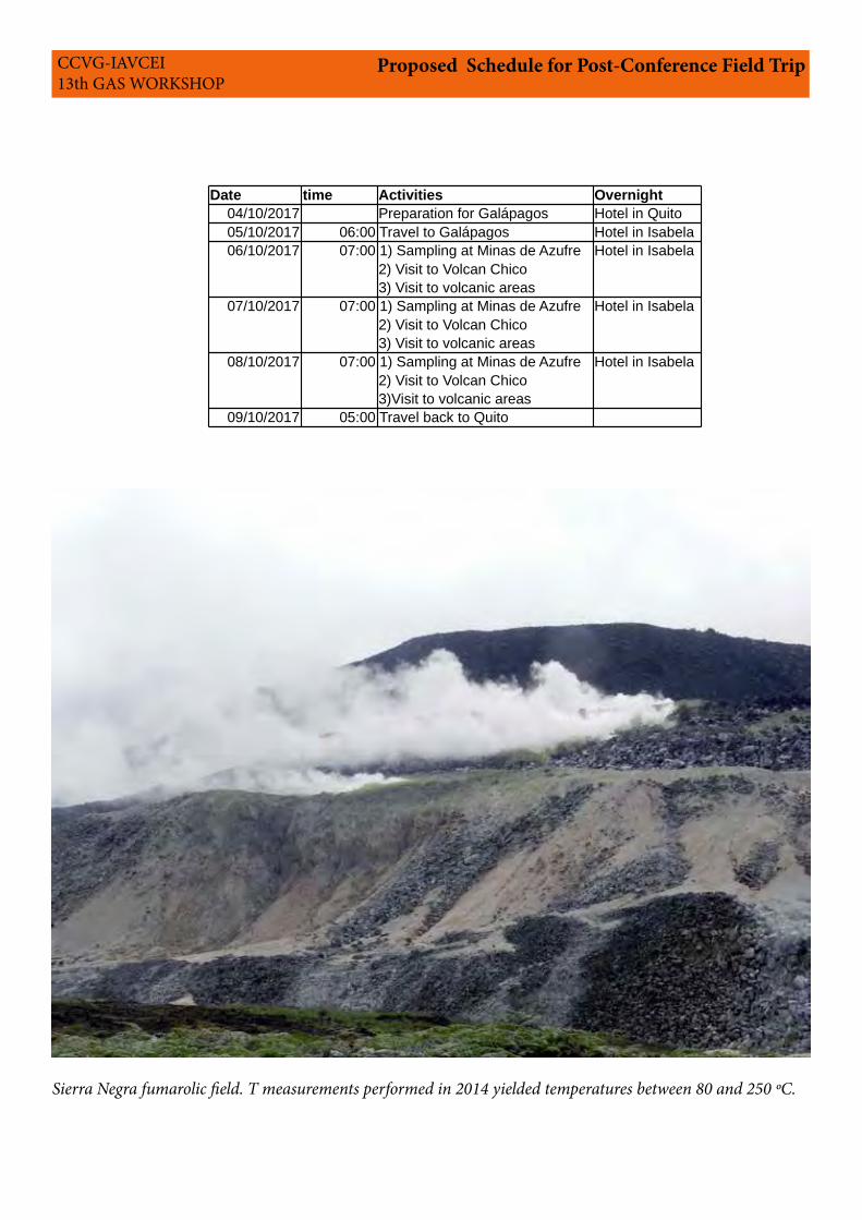
Sierra Negra fumarolic field. T measurements performed in 2014 yielded temperatures between 80 and 250 ºC.
CCVG-IAVCEI 13th GAS WORKSHOP
Registration Fee for Workshop, Tungurahua and Cotopaxi, Pululahua or Guagua Pichincha Field Trips
Single room: 1340 USDDouble room: 1135 USDStudents : 900 USD
These prices include:- Workshop materials: T-shirt, pen, field notebook.- Ice-breaker- Transportation.- Accomodation at Quito on 24 and 30 September and from 1 to 3 October. - Accommodation and meals at Baños - Field transportation and meals including coffee breaks and box-lunches.- Transport to the airport only on October 4.Not Included:- One dinner at Baños- Four dinners at Quito
Optional Pre workshop field trip to Reventador
Price: 450 USD
Includes:- Transportation from, during and back to Quito- Local guides - Excursions mentioned in the Itinerary- Shared Lodging (1 night Hotel Reventador & 2 ni-ghts Camping) - Full board (4 Lunches, 3 Dinners & 3 Breakfasts)- Equipment: Rubber boots, Sleeping bag and Mat
Optional Post workshop field trip to Galápagos
Double room: 1800 USD
This price includes:- Flight ticket from Quito- Accomodation and meals- Field campaing at Sierra Negra- Visit to Volcán Chico- Visit to volcanic areas
COSTS
Local Organizing CommitteeSilvana HidalgoPatricio RamónInstituto Geofísico - Escuela Politécnica NacionalParque Nacional Galápagos
LogisticsJonathan Hall, Ecuadorian Journeys
IAVCEI Organizing CommitteeFranco Tassi, Leader CCVGNicole Bobrowski, Leader CCVGTaryn Lopez, CCVG SecretaryMaarten de Moore, CCVG Editor & Webmaster
Important Note: Ecuador has placed a requirement to enter the country. Your passport must be valid for at least 6 months. It cannot expire within 6 months of your travels within Ecuador. You will not be allowed to board the plane to travel.You are required to have Health Insurance to enter the country.
Important Dates
Third circular:April 2017Pre-registration and fee payment start date:May 2017Pre-registration and fee payment final date:June 1, 2017Abstracts deadline:June 1, 2017Registration fee payment final date:August 15, 2017Pre-conference MeetingSeptember 21 to September 24, 2017Workshop:September 24 to October 3, 2017Post-Conference MeetingOctober 5 to October 9, 2017
CCVG-IAVCEI 13th GAS WORKSHOP
Pictures:Cotopaxi: Marjorie Encalada, Benjamin Ber-nard, Silvana HidalgoTungurahua: Silvana Hidalgo, Francisco Vásco-nezGuagua Pichincha : Patricia MothesPululahua : Patricio RamónGalápagos: Francisco Vásconez, Benjamin Ber-nardReventador: front page: Liz Gaunt, descripive of the field trip: Francisco Vásconez