Embed Size (px)
Citation preview

World Journal of Fish and Marine Sciences 2 (5): 427-435, 2010ISSN 2078-4589© IDOSI Publications, 2010
Corresponding Author: RüÕtü Ilgar, Department of Geography Education, Campus of Anafartalar,Çanakkale Onsekiz Mart University, Turkiye
427
Investigation of Transit Maritime Traffic in the Strait of Çanakkale (Dardanelles)
RüÕtü Ilgar
Department of Geography Education, Campus of Anafartalar, Çanakkale Onsekiz Mart University, Turkiye
Abstract: Dardanelles is a 61 km (28 mile) long and from 1.2 to 6.4 km (3/4 to 4 miles) vital transportation bridgebetween the Black Sea and Mediterranean Sea. It separates Asian Turkiye from European Turkiye (Trace), thusit also separates the two continents. This strategically important strait is the Dardanelles. It leads from theAegean Sea to the Sea of Marmara and to the Black Sea. Marmara is a small harbor sea in Turkiye, connectedto the Black Sea by the Istanbul Strait (Bosporus) and to the Aegean Sea by the Çanakkale Strait (Dardanelles).Thus the Dardanelles is the outer gateway to a great productive area. It deals with increasing ecologicalproblems for the last 50 years that concentrations of the organic and inorganic toxic substances in the sea waterand sediment are high due to municipal and industrial wastes because of Marmara Coastline city (mainly ¤zmit,¤stanbul, Tekirdað, Band2rma and Black Sea Country City and South and Central Europe via Dune. The fish andnatural life exposed to these compounds are negatively affected. The world's ships must pass through here toreach the grain ports oil ports of Black Sea Country’s and the Caucasus region. A total of 49 thousand 453 shipspassed the Straits of the Dardanelles in 2009. Increase in the volume of maritime traffic on the Çanakkale Straitand the Sea of Marmara have increased the risk of the maritime accidents over the years. 152.725.704 tone /yearusing petroleum tanker floating by Çanakkale Strait.
Key words: Marine traffic % Maritime % Vessel % Dardanelles % Turkiye
INTRODUCTION to 6 km/h. A deep current flows from the southwest to the
Turkiye is divided by a complex waterway that 38.5 parts per thousand) and dense (1.028–1.029) water.connects the Black Sea to the Sea of Marmara and the Dardanelles is a 61 km (28 mile) long and from 1.2 to 6.4 kmAegean Sea. The channel passing between the Black Sea (3/4 to 4 miles) vital transportation bridge between theand the Sea of Marmara is named the Istanbul Strait more Black Sea and Mediterranean Sea. commonly called the Bosporus. Istanbul is positioned at Turkiye, as the third largest importer of Russian gasthe south end of the Bosporus. The Sea of Marmara is after Germany and Italy, depends on Russia for almostconnected to the Aegean Sea by a channel called the two-thirds of its gas imports [2]. As a result, someÇanakkale Strait also known as the Dardanelles. The Caspian Basin states are now considering exporting theirTurkish Straits are very narrow and wind more like a river hydrocarbons via Russia even if that gives Moscowthan the sea. These straits are some of the most leverage over them [4] while some Western countries thatdangerous waterways in the world for maritime travelers want to punish Russia are discussing allowing exports via[1]. The Dardanelles originated as a river valley that Iran [5], causal factors of oil cargo spills and tanker bargebecame inundated by the sea as a result of the land’s vessel accidents, while Anderson and Talley [6]subsidence. Length, 120.5 km; width, 1.3 - 18.5 km; depth. investigates the main factors of the risk and the severity53–106 m. The banks of the Dardanelles are composed of of container cargo accidents. Similarly Psaraftis et al. [7],sandstones and limestone, covered with sparse these straits are some of the most dangerous waterwaysvegetation. The water exchange through the Dardanelles in the world for maritime travelers. Resulting from thisis determined by the difference in the water densities of massive transportation, the annual global anthropogenicthe two adjoining seas. The surface current, flowing from marine oil discharge has been estimated to be aroundthe Sea of Marmara in the northeast toward the 4.15 million tons [8]. This waterway with its sharp turnssouthwest, carries fresher, less dense waters (with a (12 within the Strait of TSS, some up to 80º and six withinsalinity of between 25.5 and 29.0 parts per thousand and the Strait of Çanakkale. 8 times mucher then Panamaa density of 1.018). The velocity of current ranges from 2 Canal, 50 000 ships passed through this narrow canal
northeast and carries from the Aegean Sea saline (up to

World J. Fish & Marine Sci., 2 (5): 427-435, 2010
428
Fig. 1: The Location of Study Area
between the Mediterranean and Black Sea. At the other (Dardanelles) which is located near the Çanakkale cityend of the Mediterranean, the Straits of Gibraltar are center. Long controlled (1402-1918) by the Ottomantraversed by over 80,000 vessels; Çanakkale take a place Empire, it was a primary factor in the Eastern Question ofmain city and Gelibolu in coastline. Whilst natural oil the 19th century and the scene of an intensive Alliedseepages into the sea are around 600,000 tons [9] a risk for campaign in World War I. Britain's War Council discussedspecies invasions, as these vessels were found to carry the possibility of attacking Turkiye in order to re-open thean average of 60 tons of residual, unpumpable water and Dardanelles Straits. it was decided to send British troopssediments [10]. Çanakkale Strait is possible effecting and units of the Australian and New Zealand Corpshabitats as passing 49 thousand 453 vessel. (ANZAC) to arrive Russia. But Turkish hero created
Background and Legal Status: The Dardanelles has been Elizabeth, Lord Nelson, Agamemmon, Inflexible, Ocean,a strategic water route-and an object of conquest- Irresistible, Prince George and Majestic from Britain andthroughout history. It is famous for Troy and Fist War the Gaulois, Bouvet and Suffren from France. At first theymarine conflict. That takes progress and alters as a made good progress until the Bouvet struck a mine,continuous from past (BC, Anatolian Principalities and heeled over, capsized and disappeared in a cloud ofOttoman period) to today had came important and smoke. Soon afterwards two more ships, Irresistible andincrease from every time. Dardanelles called the Ocean hit mines.Hellespont in ancient times; the strait is associated with The United Nations Convention on Law of the Seathe legend of Hero and Leander. The modern name comes (UNCLOS) (art. 35/c, 311/5). This article also recognizesfrom Dardanus, mythical ancestor of nearby Troy. The the established regimes for the Gibraltar, Danish andrichness of the ancient Troy owed to the wind because Magellan Straits. In legal terms, this means the exclusion,ships refuge coast by channel. Çanakkale Strait in principle, of the provisions of Part III (art. 34-45) of
biggest marine war in The Strait. The fleet included Queen

World J. Fish & Marine Sci., 2 (5): 427-435, 2010
429
UNCLOS to those straits [11]. The Montreux Convention destructions besides the loss of life and propertyregulates the legal regime of the Turkish Straits and this and also strategic and economic importance. Theis recognized by European Country. The Montreux Çanakkale Straits both geographically andConvention implicitly gives Turkey the power to adopt metaphorically connect Europe to Asia. The TSS aresuch a regulatory scheme [12]. The International the most unique amongst others due to othersConvention for the Prevention of Marine Pollution from physical, hydrological and oceanographicShips, (MARPOL), International Regulations for characteristics, as well as the complicatedPreventing Collisions at Sea, 1972 (COLREG) [13], 1978) navigational conditions. Turkish Government has takenwas accepted by Turkish government [14] are related several constructive steps forward to enhance thestrait rules. The International Maritime Organization navigation through the Strait, inter alia, maritime traffic(IMO), as a consequence of this UN document, started to rules and the VTMIS. refer to the Straits as the Strait of Istanbul, Strait ofÇanakkale and the Marmara Sea. Turkey, due to these Traffic Scheme: Çanakkale Strait is divided 3 strategicallyfacts and as the sovereign state of the Straits, started to regional transport and naval ship telecommunication.officially use the term 'Turkish Straits' in its domestic Çanakkale Straits not only have geopolitical andlegislation, Turkish Government is set The Traffic strategic significance, but also rapidly increasingSeparation Scheme (TSS) which maritime traffic importance for international transportation, both for theregulations have been implemented for indicates that the Black Sea states and for the whole world. This waterwayyearly casualty rate has sharply been reduced especially with its sharp turns (12 within the Strait of Istanbul, someafter 1998 rules. up to 80º and six within the Strait of Çanakkale also in
RESULTS AND DISCUSSION places to less than a nautical mile) creates real dangers
The Çanakkale Strait is the most dangerous restrictions also create dangers for the environment,waterway in the world and serious maritime accidents including the human and marine environment. There foroccurred in the past causing severe environmental strait is divided 3 local areas.
certain places reaching 80º) and narrowness (in some
for safety of passage and navigation. Those physical
Fig. 2: Çanakkale Strait Sectoral Area Which Establish Risk Scenario

World J. Fish & Marine Sci., 2 (5): 427-435, 2010
430
Fig. 3: Sector Gelibolu, Enterence from Marmara in Çanakkale Strait
Fig. 4: Dangerous Areas Sector Nara Middle of Çanakkale Strait
Gelibolu Control Station put in order by VHF Channel and the bend of Nara. Vessels should also take every11, prior 30 nm to Gelibolu Light House and asking for precaution to avoid meeting other vessels in the areaspermission to enter Dardanelles Strait. When you get between Kilitbahir and Çanakkale, between Nara and Kilia,green light from the Control Station, calling also Gelibolu between Gelibolu and Cardak; and, when the current orPilot by VHF Channel 71 advising position and stand by weather is in their favor should give way to oncomingon VHF Channel 11/71 till entering the Dardanelles and vessels by stopping or reducing speed.then switch to VHF Channel 13 till leaving the Dardanelles Çanakkale Strait approximately 90 degrees turningStrait. make ship maneuvering difficult at Nara Turning point.
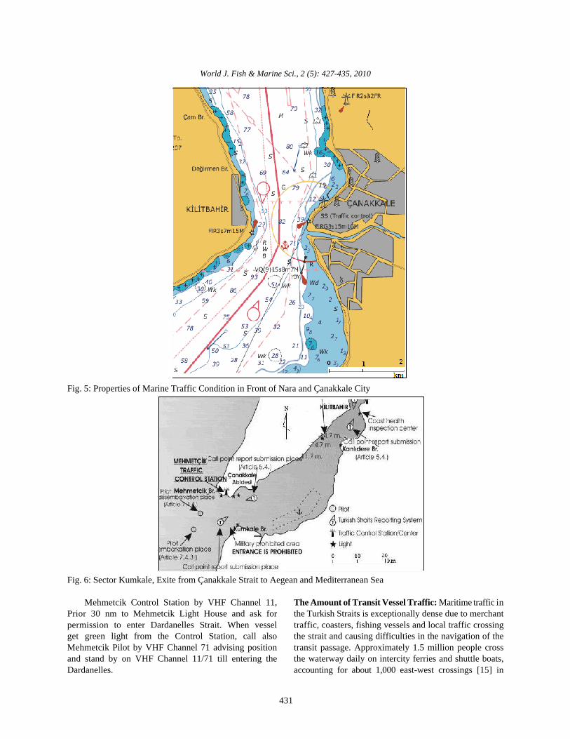
The Dardanelles, vessels should, in accordance with Current speed is 4 knots at Nara turning point is obviousrules of Regulations for Prevention Collisions at Sea, keep which would also negatively affect navigation. Nara is theto that side of mid-channel which lies on their starboard shortest sector and has a sharp turning point both of side.side, taking care to make sound signals in accordance There is environmental potential risk on to Çanakkale citywith the rule when approaching the narrows of Çanakkale on a account of Nara corner.
World J. Fish & Marine Sci., 2 (5): 427-435, 2010
431
Fig. 5: Properties of Marine Traffic Condition in Front of Nara and Çanakkale City
Fig. 6: Sector Kumkale, Exite from Çanakkale Strait to Aegean and Mediterranean Sea
Mehmetcik Control Station by VHF Channel 11, The Amount of Transit Vessel Traffic: Maritime traffic inPrior 30 nm to Mehmetcik Light House and ask for the Turkish Straits is exceptionally dense due to merchantpermission to enter Dardanelles Strait. When vessel traffic, coasters, fishing vessels and local traffic crossingget green light from the Control Station, call also the strait and causing difficulties in the navigation of theMehmetcik Pilot by VHF Channel 71 advising position transit passage. Approximately 1.5 million people crossand stand by on VHF Channel 11/71 till entering the the waterway daily on intercity ferries and shuttle boats,Dardanelles. accounting for about 1,000 east-west crossings [15] in
World J. Fish & Marine Sci., 2 (5): 427-435, 2010
432
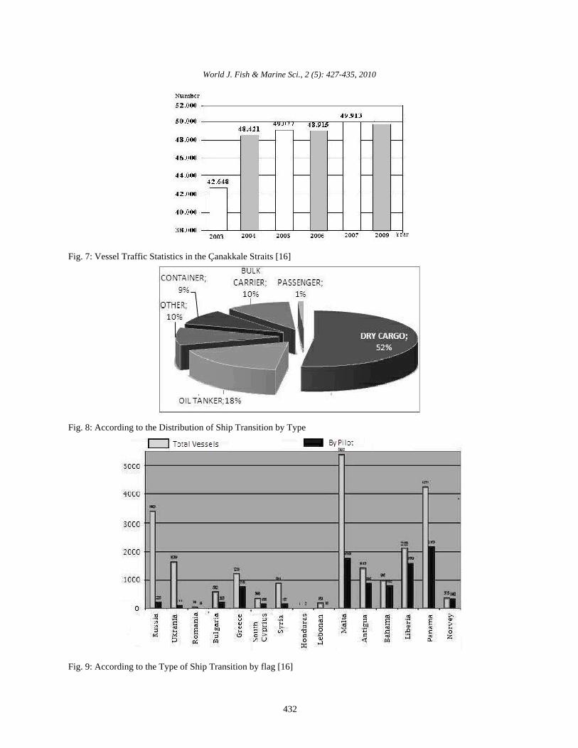
Fig. 7: Vessel Traffic Statistics in the Çanakkale Straits [16]
Fig. 8: According to the Distribution of Ship Transition by Type
Fig. 9: According to the Type of Ship Transition by flag [16]

World J. Fish & Marine Sci., 2 (5): 427-435, 2010
433
Table 1: Amount of Transit Vessel Traffic Statistics in the Çanakkale Straits
Year Total Vessel with Pilot % Sp1 Giving % non Stop % >150M % <150M % >500GT % <500GT %
1995 35459 8292 23 12382 35 23249 66 27295 77 8164 23 3797 11 31662 89
1996 36198 10307 28 13550 37 24072 67 27894 77 8304 23 1409 4 34789 96
1997 36543 11047 30 13570 37 24668 68 28032 77 8511 23 1117 3 35426 97
1998 38777 11448 30 17692 46 25136 65 36383 94 2394 6 1482 4 37295 96
1999 40582 10002 24 24553 61 26900 66 38014 94 2568 6 1492 4 39090 96
2000 41561 11130 26 33861 82 27033 65 38864 93 2697 7 1398 3 40163 97
2001 39249 10704 27 37525 96 26452 67 36289 92 2960 8 936 2 38313 98
2002 42669 12164 28 42077 99 29900 70 39004 91 3665 9 689 2 41980 98
2003 42648 13020 30 42648 100 29114 68 38925 91 3723 9 677 2 41971 98
2004 48421 14404 30 48421 100 36310 75 44504 92 3917 8 1327 3 47094 97
2005 49077 15661 32 48979 100 34784 70 44585 91 4492 9 1211 2 47866 98
2006 48915 16871 35 48264 99 32061 66 44070 90 4845 10 1404 3 47511 97
2007 49913 16885 33 48802 97 31981 64 44968 91 4945 9 1873 4 48040 96
2008 48978 18334 37 48565 99 31981 65 43755 89 5223 9 844 2 48134 98
2009 49453 18588 38 49210 99 32559 66 44277 90 5176 10 615 1 48838 99
Table 2: Usage Pilot and Vessel Traffic Condition in the Çanakkale Straits
Year Total Use Pilot SP I Report Ship of >200m Ship of >500 Transit Pass Tanker
1995 35.450 8.292 12.382 8.164 31.662 23.554 5658
1996 35.387 10.307 13.473 8.304 34.789 24.668 5658
1997 36.543 10.307 13.473 8.304 34.789 24.061 6043
1998 38.777 11.448 17.692 2.394 37.295 25.137 6546
1999 40.582 10.002 24.533 2.568 44.354 26.900 7266
2000 41.561 11.130 33.861 2.697 40.163 26.849 7529
2001 39.249 10.703 - 2.960 38.313 26.443 7064
2002 42.669 12.164 42.477 3.665 41.980 29.600 7637
2003 42.648 13.020 42.648 3.892 42.530 29.120 8114
2004 48.421 14.404 31.469 2.496 30.602 36.123 9016
2005 49.077 15.661 - 4.492 47.866 34.387 8813
2006 48.915 16.871 - 4.845 47.511 32.061 9567
2007 49.913 16.885 48.802 4.945 48.040 31.892 9271
2008 48.978 18.334 48.565 5.223 48.134 31.981 8358
Istanbul strait. No other city in the world is exposed to the Dangerous Cargo and Accidents of Maritime Traffic:transit of such volatile cargo every day. The nature of Çanakkale Strait and the existing grave A total of 49 thousand 453 vessel are transit passed situation created dense traffic congestion. In this case,from Çanakkale Strait in 2009 [16] It is mean 135 ships per the strait cannot bear additional oil shipments withoutday pass. A total 5 176 ships big a 200 m in a total 49 453 putting into danger the safety of Çanakkale, the lives ofship and 9 576 is a oil tanker. A a result vessels are its population and its unique historical and precariousincreasing year by year. environment. The increase in the maritime traffic becomes
While there are no strict length or draft limits more dramatically, reviewing the number of ships passingon vessels using the Dardanelles Strait, vessels through the Straits carrying dangerous cargo. Presentsbetween 150 and 200 meters long and/or with a and analysis on the factors that are importantdraft between 10 and 15 meters must report to the determinants of maritime transportation risk [17]. TurkishTraffic Control Center no less than 24 hours Strait Systems is under ever increasing tanker traffic. Thebefore entering the Dardanelles Strait. Larger vessels must increase in the number of tankers carrying dangerousreport no less than 48 hours before entering the Turkish cargo through the Strait between years 1996-2009 Thestraits. transit traffic consists of the goods imported and exported
Annual tonnage of dangerous cargo passing through by the Black Sea countries and also, at an alarminglythe Çanakkale Straits as bellow: increasing rate, of the oil LNG and LPG. In the past decade

World J. Fish & Marine Sci., 2 (5): 427-435, 2010
434
Fig. 10: The Amount of Ships per-Year Pass in Çanakkale Strait [2]
Fig. 11: The cause of the accident in Çanakkale Strait
Fig. 12: Types of ships involved in the accident in Çanakkale Strait
the system consisting of the Istanbul and means of oil transportation and oil makes up over 35% ofÇanakkale Straits with the inner Sea of Marmara among is the annual tonnage of all sea cargoes [2]. Tankersa major oil hub the other world energy transportation transport almost 60% of the oil consumed in the worldsystems. [18].
The number has reached to 8358. The amount of Ship accidents in the TSS are examined mainly underdangerous cargo being carried through the Straits has four categories; collision, grounding, fire and stranding.increased 138%, being 60.1 million tons in 1996 and 143.5 Each has a distinct effect on the marine ecosystem.million tons in 2005 (Figure 10). Collision is the dominant type of accident in the area. It is
The amount of oil transported by sea worldwide caused by poor visibility and strong currents. Mainlyincreased from 1.3 billion tons in 1988 to over 2 billion ships are breakdown and dry cargo types. It is presentedtons in 2004 [3]. Marine transportation is the primary Figure 12.
World J. Fish & Marine Sci., 2 (5): 427-435, 2010
435
Prevent of accident must be use pilot system. 8. Berthe, C.L. and T. Hopner, 2004. Geo-biologicalBecause The Dardanelles Strait is almost 38 nautical miles Aspects of Coastal Oil Pollution’. Palaeogeography,with a width of from 0.7 to 1.1 nautical miles and it Palaeoclimatology, Palaeoecology, 219: 171-189.contains a very sharp turn at the narrowest point near 9. Committee on Oil in the Sea 2002. Inputs, Fates andÇanakkale. Turkish vessels over 150 meters long must use Effects, Ocean Studies Board and Marine Board,a pilot, but other vessels are recommended to use a pilot, Divisions of Earth and Life Studies andeven though it is not required for transit vessels. Vessels Transportation Research Board, National Researchnot using a pilot in the Dardanelles Strait may expect Council.longer waits than those with pilots. Masters, owners or 10. Bailey, S., I. Duggan, C. van Overdijk, P. Jenkinsagents of the vessels carrying dangerous cargo and and H. MacIsaac, 2003. Viability of Invertebratewhich are 500 gross tons and more, 24 hours before Diapausing Eggs Collected from Residualentering the entrance of the Strait of Istanbul and the Ballast Sediment. Limnology and Oceanography,Strait of Çanakkale, shall give Sailing Plan I (SP I) as 48: 1701–1710.determined by the administration. 11. ¤nan, Y., 1995. Türk Boðazlar2n2n Siyasal ve Hukuksal
REFERENCES Straits), 2nd edition, Turhan Kitapevi, Ankara,2: 2-3.
1. Ilgar, R., 2002. Çanakkale Boðaz Ekosisteminde the Turkish Straits: A Test for Modern InternationalUlaÕ2m Faaliyetleri, Doðu Coðrafya Dergisi, Eastern Law, Emory International Law Review Springer,Geographical Review, Eylül, 8: 23-30. 10: 1-2.
2. Devlet Planlama Teskilati-DPT 2007. Specialized 13. Turkish Official Gazette 1978. 29 April 1978-16278.Commission Report on Oil and Oil Product Industry 14. Turkish official Gazette, 1984. l8 November 1984-of 9th National Development Plan 2007-2013 18579.(in Turkish), Ankara 15. John, C.K. Daly, 2008. Tankers, Pipelines and the
3. Mitropoulos, E.E., 2007. Shipping’s Environmental Turkish Straits, Eurasia Daily Monitor June 26.,Credentials, Where to focus our attention now. Jamestown Foundation, Washington, D.C. WMO. Available at: http://www.imo.org/ 16. Maritime Affairs Sector Report, 2010. VesselInfoResource/ mainframe.asp?topic_id=406&offset=7 Traffic Statistics in the Çanakkale Straits, ConfidentialOil in the sea: III. Inputs, fates and effects. Report, Ministry of Transportation, GeneralWashington, DC: National Academy Directorate of Coastal Security, obtained from thePress.Available online at http://www.nap.edu/ Turkish representative to the International Maritimeopenbook. php?isbn=0309084385 Organization.
4. Alexander, L., 2008. "Seeking a Way Forward on 17. Le Blanc, L.A. and C.T. Rucks, 1996. MultipleTrans-Caspian Pipeline," Radio Free Europe/Radio Discriminant Analysis of Vessel Accidents, AccidentLiberty, Spiegel Online (Hamburg), Sept. 2, Analysis and Prevention, 28: 501-510.
5. Goble, P., 2008. Assessing The Global Impact of 18. Burgherr, P., 2007. In-depth Analysis Of AccidentalRussia's Aggression in Georgia, Radio Free Oil Spills From Tankers in The Context of Global SpillEurope/Radio Liberty, Sept. 3, Trends From All Sources, Journal of Hazardous
6. Anderson, E. and W.K. Talley, 1995. The Oil Spill Materials, 140: 245-256.Size of Tanker and Barge Accidents: Determinantsand Policy Implications, Land Economy, 71: 216-228.
7. Psaraftis, H.N., 1998. Panagakos, G., Desypris, N.and Ventikos, N., "Analysis of MaritimeTransportation Risk Factors", Proceedings of the 8thInternational Offshore and Polar EngineeringConference, Montreal, Canada, 4: 477-483.
Rejimi (The Political and Legal Regime of the Turkish
12. Scharfenberg, S.A., 1996. Regulating Traffic Flow in