Embed Size (px)
DESCRIPTION
Investigation of the use of deflections of vertical measured by DIADEM camera in the GSVS11 Survey. YM Wang 1 , X Li 2 , S Holmes 3 , DR Roman 1 , DA Smith 1 , S Guillaume 4 and B Bürki 4 1 National Geodetic Survey, NOAA, USA 2 ERT Inc. USA 3 SGT Inc. USA - PowerPoint PPT Presentation
Citation preview

Investigation of the use of deflections of vertical measured by
DIADEM camera in the GSVS11 Survey
YM Wang1 , X Li2 , S Holmes3 , DR Roman1 , DA Smith1 , S Guillaume4 and B Bürki4
1 National Geodetic Survey, NOAA, USA2 ERT Inc. USA3 SGT Inc. USA4 Institute of Geodesy and Photogrammetry, Federal Institute of Technology Zürich, Switzerland
European Geosciences Union General Assembly 2013
Vienna | Austria | 07 – 12 April 20131
Outline• Goal: to compute a geoid profile of 325 km long to the sub-cm differential accuracy using GSVS11 data (GPS, Leveling, DoV, gravity, DEM data)
• Data accuracy of GSVS11
• Geoid computation using DoV data, and the effect of the systematic bias on the geoid along the line
• Geoid profile using spectral combination of GPSL and DoV
• Geoid models evaluation and differential accuracy estimation
• Conclusions and future work2

Location of GSVS11
3
325 km218 points1.5 km spacing

Accuracy of gravimetric and geometric data of GSVS11
At each benchmark (~1 mile spacing along the line):-Ellipsoidal height (24-48 hours GPS obs. time), OPUS project used for data processing (σ = ±3-4 mm)
-Leveled elevation of the 1st order class II specification (σ=±0.7 mm, ~13 mm over 325 km)
-DoV observations by DIADEM camera (σ= ± 0.1”)
-Absolute and relative gravity (σ < ± 20 microGal)
4
d
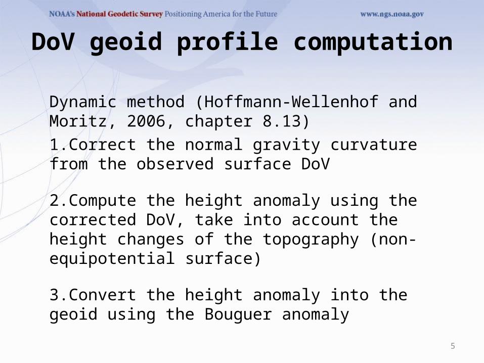
DoV geoid profile computation
Dynamic method (Hoffmann-Wellenhof and Moritz, 2006, chapter 8.13)
1.Correct the normal gravity curvature from the observed surface DoV
2.Compute the height anomaly using the corrected DoV, take into account the height changes of the topography (non-equipotential surface)
3.Convert the height anomaly into the geoid using the Bouguer anomaly
5
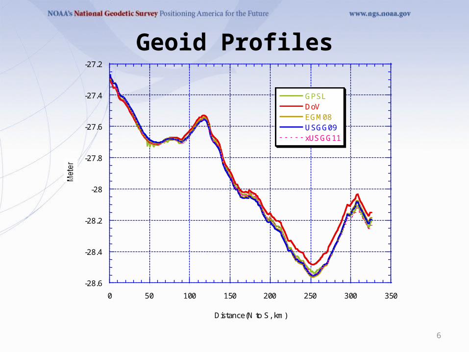
Geoid Profiles
6
-28.6
-28.4
-28.2
-28
-27.8
-27.6
-27.4
-27.2
0 50 100 150 200 250 300 350
GPSLDoVEGM08USGG09xUSGG11
Distance(N to S, km)

Geoid differences
7
-5
0
5
10
0 50 100 150 200 250 300 350
DoV-EGM08DoV-GPSLDoV-xUSGG11xUSGG11-GPSL
Distance(N to S, km)

Geoid differences (in mm)
8
GPSL-DoV
USGG09-DoV
EGM08-
DoV xUSGG11-DoV
xUSGG11-GPSL
Mean -29.7 -30.2 -29.6 -34.5 -4.8
STD 25.4 33.0 32.6 29.6 9.5
RMS 39.1 45.0 44.1 45.5 10.7
Min. -16.7 -77.0 -83.0 -88.0 -40.4
Max. 89.3 28.0 30.0 10.0 32.8

Contribution of “suspected” biases in DoV data to the geoid
9
-0.1
-0.08
-0.06
-0.04
-0.02
0
0 50 100 150 200 250 300 350
Distance(N to S, in km)
Mean xi = -0.075"Mean eta = 0.009"

Power spectral density (PSD) of the residual geoids
10

Spectral combination (GPSL+DoV)
GPSL geoid is accurate at long wavelength, and DoV geoid is precise at short wavelength:
where is the cut-off frequency. The value used in this study corresponds to the wavelength of 96km.
11
)()1()(00
i
N
iDoVii
N
iGPSLicomb fwfwN
0
0
0
1
ni
niwi
0n

High frequency error removed from GPSL geoid profile
12
-3
-2
-1
0
1
2
3
4
0 50 100 150 200 250 300 350
GPSL-Comb.
Distance(N to S, km)

(geoid model – Comb.) along the line
13
-4
-3
-2
-1
0
1
2
3
4
0 50 100 150 200 250 300 350
USGG09-Comb.xUSGG11-Comb.EGM08-Comb.
Distance(N to S, km)

Geoid comparison (model –Comb.)
14
GPSL(mm)
USGG09(mm)
EGM08 (mm)
xUSGG11 (mm)
Mean -0.0 -0.4 0.1 -0.5
STD 7.6 16.9 17.2 6.7
RMS 7.6 16.9 17.2 8.2
Min. -22.2 -28.0 -29.1 -18.2
Max. 33.0 26.7 35.1 8.7

Estimation of differential accuracy of the combined geoid profile
15
• Thus, the differential accuracy of the combined geoid profile is probably better than 5mm.
• Then the differential accuracy of xUSGG11 is around 5mm, and can’t be worse than 6.7 mm.
222
222
22
22
2
7.6)(
7.6)11(
7.6
)()11(
)11(
mmcomb
mmxUSGG
mm
combxUSGG
combxUSGG
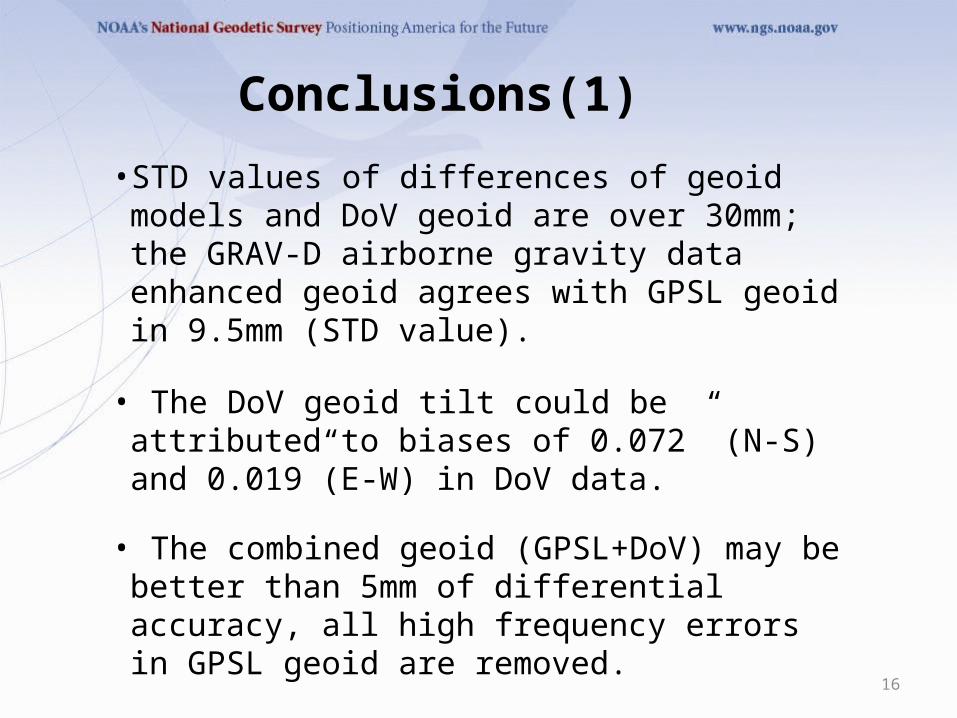
Conclusions(1)
• STD values of differences of geoid models and DoV geoid are over 30mm; the GRAV-D airborne gravity data enhanced geoid agrees with GPSL geoid in 9.5mm (STD value).
• The DoV geoid tilt could be attributed to biases of 0.072” (N-S) and 0.019”(E-W) in DoV data.
• The combined geoid (GPSL+DoV) may be better than 5mm of differential accuracy, all high frequency errors in GPSL geoid are removed.
16

Conclusions(2)
• There is a 0.04 ppm slope between xUSGG11 and GPSL geoid (which one is tilted?)
• GRAV-D airborne gravity data enhanced geoid model xUSGG11 is revealed a differential accuracy of better than 6mm.
• DIADEM camera DoV data could be useful for long traverses if the systematic biases are carefully calibrated.
17

Future Work
• Investigate the terrain effect on the DoV data interpolation and possible system biases removal
• Combine satellite gravity models (long wavelength) with DoV data (short wavelength) in geoid profile computation
18