Embed Size (px)
Citation preview
li-
Investigation of the environmental effects of an oil spill adjacent to the waters
of the Lowendal and Montebello island groups, north west Australia
6 September 1999 Marine Management Branch
Environmental Systems Division Department of Environmental Protection
Investigation Report 01-1999

ISBN 0 7309 8056 1
ISSN 1030 - 0600
Investigation of the environmental effects of an oil spill adjacent to the waters of the Lowendal and Montebello island groups, north west Australia
R J Masini
6 September 1999 Marine Management Branch
Environmental Systems Division Department of Environmental Protection
Investigation Report 01-1999


Contents
Summary
1.0 Background
2.0 Overview of previous investigations
3.0 Current investigation 3.1 Site Selection 3.2 Sampling approach
4.0 Findings
5.0 Conclusions
Figures
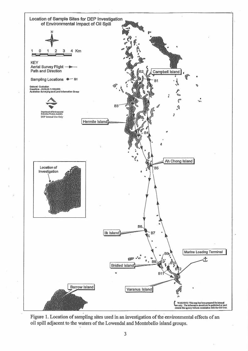
Figure 1. Location of sampling sites used in an investigation of the environmental effects of an oil spill adjacent to the waters of the Lowendal and
Page
1
2
2
4 4 6
6
10
Montebello island groups. 3
Tables
Table 1. Sampling details for DEP investigation of the environmental impact of an oil spill that occurred on 26 July 1999 from the Apache Energy Limited Varanus Island Marine Loading Terminal. 7
Table 2. Concentrations ofBenzene, Toluene, Ethyl-benzene, Xylene and Total BTEX in beach sand samples collected from islands in the Lowendal and Montebello island groups. All results are expressed on a dry weight basis. 8
Table 3. Total petroleum hydrocarbon (TPH) concentrations in beach sand samples collected from islands in the Lowendal and Montebello island groups. All results are expressed on a dry weight basis. 9
Table 4. Quality assurance details provided by Australian Government Analytical Laboratories for hydrocarbon analyses performed on sand samples collected from the Lowendal!Montebello islands 16-17 August, 1999. All results are expressed in percentage(%) or mg kg-1 wherever appropriate on a dry weight basis. LOR= Limit of Reporting. TJ;>H =Total Petroleum Hydrocarbon. 10
Plates
Plate 1. · Beach on Ilk Island, in the Lowendal Island group photographed on Monday 16 August. An oil-derived sheen was reported running off this beach on the morning of 29 July 1999. No evidence of oil was found during
Page
visual inspection conducted in the afternoon of Monday 16 August. 5

Sumnzary
Officers fi"orn the Department of Environmental Protection and the Department of Minerals and Energy unde,:took a low-altitude helicopter-based survey of the islands and waters of the Lowendal and Montebello island groups on 16-17 August 1999, to investigate the environmental implications of an oil spill fi"om the Varanus Island Marine Loading Terminal located approximately 4.2 km north east of Varanus Island. The survey consisted of general observations from the ai1~ supplemented by on-ground observations and collection of beach sand samples from 11 sites on 6 islands within the Lowendal and Montebello island groups that were considered to have had the greatest likelihood of having come into contact with spilled oil.
There was no evidence of oil on any beaches/rocky shores of the Lowendal and Montebello island groups or on the water swface within or around the island groups during the aerial survey.
There was no evidence of oil on beaches. The strandline was clear of oil. There were no oiled wildlife seen and no visible hydrocarbon layering in the sand profile to a depth of approximately 50 em and no hydrocarbon odours noted in swface sands or in subswface sands or water. All mangrove communities examined appeared healthy and showed no signs of oiling or stress.
Beach sand samples contained no detectable benzene, toluene, ethylbenzene or xylene and no detectablepetrolewn hydrocarbons (C6-C9, C10-C14, C15-C28, C29-C36).

1.0 Background
On Monday 26 July the crude oil tanker MN TORUNGEN took up station to receive oil from the Varanus Island Marine Loading Terminal located approximately 4.2 km north east of Varanus Island (Figure 1 ). The offshore terminal consists of a 72m flexible loading hose connected to a pipeline-end manifold (PLEM) at the end of a 4.2 km steel pipe running along the seabed from the Apache Energy facility on Varanus Island. The end of the loading hose is marked by a surface buoy connected to the hose end via a length of chain. At approximately 1220 h on 26 July a crane on the tanker was being used to raise the loading hose in order to connect it to the tanker's cargo manifold to receive crude oil from the offshore terminal. A length of chain on the flexible hose became entangled with a subsea purge valve on the rigid section of the pipe and the pressure exerted by the crane as it attempted to lift the flexible loading hose sheared off the valve leaving a hole of approximately 120 mm in diameter.
It is estimated that approximately 25 m3 of Harriet light crude escaped from the hole in the pipe over an 11 - 12 hour period before a diving team closed an underwater shut-off valve and isolated the holed section to initiate repairs.
Initial estimates of the volume of oil lost ranged from 5 m3 to 200 m3. The lower estimate was
based on an initial visual appraisal of the amount of oil on the sea surface and the higher was based on a worse case scenario previously modelled for the terminal. The final estimate . ( ~ 25 m3
) was determined by officers of the Department of Minerals and Energy (DME) and is consistent with observations of the areal extent of the slick and equates to the volume of water trapped in the loading line after it had been repaired (as measured by the amount of water in the hold of the tanker after cargo loading had been completed).
2.0 Overview of previous investigations
An oil spill response was initiated consistent with Apache's approved Oil Spill Contingency Plan (OSCP). The plan involved alerting relevant Government agencies and monitoring the size ofthe spill, the direction the spilled oil was travelling and the likely fate ofthe oil so as to enable deployment of oil spill booms to deflect oil from sensitive shorelines if necessary. Regular "situation reports" were prepared and distributed to members of the Technical Advisory Committee to the National Plan State Committee for Combatting Marine Oil Pollution. The Technical Advisory Committee includes representatives of the Department of Environmental Protection (DEP), Department of Conservation and Land Management (CALM), Fisheries Western Australia (FWA) and the DME.
A DME inspector conducted an aerial assessment of the extent of the spill and the potential for shoreline contact during the period 27- 28 July (2 days immediately following the spill). Windrows of sheen and emulsified crude averaging 2 - 3 km in length were reported predominantly to the north of the offshore terminal. The DME inspector reported no observed oil contact with shorelines of islands in the Montebello or Lowendal Island groups. Apache personnel tracked the location of the windrows via helicopter and marine vessels over the next four days. By Saturday 31 July there was no observable sheen in the area.
2
•.
Location of Sample Sites for DEP Investigation~ of Environmental Impact of Oil Spill . _,
N ., p
+ .,~~ <? • J',.
1 0 2 3 4 Km 4'.,. ~· ----- -KEY Aerial Survey Flight ~ Path and Direction
Sampling Locations ..- B1
Ottuet CUstodan CQ!sUine • AUSUG 1:100,000: hJstraian &J!Ve)C/10 and Land lnfomlltia> Group
_ ..... ir .........
Pnef'Cfklt " '.-Ccn Aa.llnlit
OEP lnt<mal UR Only
,'!\
. .
0 . 'I!
•,t:>. ~
.I> . c:::, . ~ •
'o•
.~ ..
Figure 1. Location of sampling sites used in an investigation of the environmental effects of an oil spill adjacent to the waters of the Lowendal and Montebello island groups.
3
Between 30 July and 3 August the DME conducted an on-site investigation of the cause of the incident which is outside the scope of the environmental investigation contained in this report.
An environmental investigation of the impacts of the oil spill was undertaken by Apache Energy commencing July 27. A preliminary report of this investigation has been provided to the DEP and forms the basis of the information provided below. A full report ofthe investigation and its findings will be prepared and submitted to relevant agencies including the DEP. The report will also include an appraisal of the performance of the predictive oil spill trajectory modelling based on field observations of the oil slicks and the results of a post-spill water sampling program.
The sampling program included collection of water, beach sand and oyster samples for hydrocarbon analysis (alkanes, BTEX or PAHs) over the period 27 July to 3 August. Apache Energy report one probable oil contact with a shoreline on a small island in the Lowendal group (informally named Ilk Island - see Figure 1) based on an airborne observation of a sheen running off a small beach on the island (plate 1) on the morning of 29 July 1999. Sand samples collected from the beach the next day were free of detectable hydrocarbon. There were no detectable hydrocarbons (alkanes, BTEX or PAHs) in any of the sand samples collected from 20 sites within th~ Lowendal and Montebello island groups. Similarly Apache Energy report (verbal communication from Iva Stejskal of Apache Energy on 19/08/99) no detectable hydrocarbons in any of 15 oyster samples collected within the Lowendal and Montebello island groups. Apart from the aerial observation of sheen running off a beach on Ilk Island, there was no reported evidence of oiling on any of the beaches, rocky areas or mangrove stands visited by the Apache Energy environmental monitoring team. There were no reported observations of oiled wildlife on any beaches. Apache personnel saw three dead birds (unidentified) in the water near the Harriet platforms.
3.0 Current investigation
Dr Ray Masini and Mr Tim Gentle from the DEP and Mr Graham Cobby from DME travelled to Varanus Island with Dr Iva Stejskal of Apache Energy on Monday 16 August to investigate the environmental implications of the oil spill with particular emphasis on determining whether there had been any significant shore-contact with islands in the Lowendal and Montebello island groups.
3.1 Site selection
The objectives of the site visit were to verify the reports prepared by Apache Energy and independently sample shoreline areas that had the highest probability of being impacted by oil from the spill. Photographs of the oil slicks taken by Apache Energy and by an officer of the DME during the period 27 - 28 July 1999 were visually inspected to identify shores in the Lowendal and Montebello island groups most likely to have come into contact with spilled oil. This information, coupled with data collected by Apache Energy on hydrocarbon levels in water and sediment collected from July 29 to August 3, was used to select sampling sites for the investigation.
4
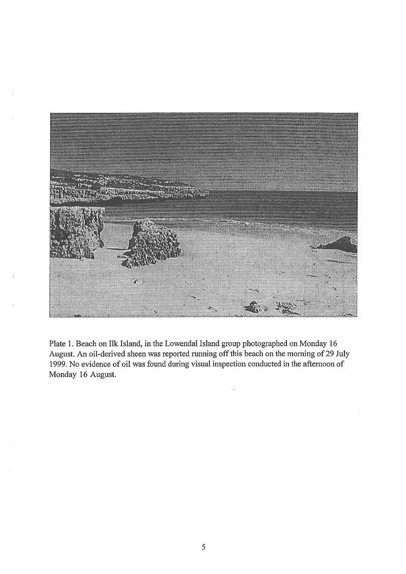
Plate 1. Beach on Ilk Island, in the Lowendal Island group photographed on Monday 16 August. An oil-derived sheen was reported running off this beach on the morning of 29 July 1999. No evidence of oil was found during visual inspection conducted in the afternoon of Monday 16 August.
5
3.2 Sampling approach
Aerial survey: A low-altitude helicopter-based aerial survey was conducted on 16 August 1999 to look for signs of oil in the waters ( eg. slicks/sheens), and on the sandy and rocky shores of islands (eg. oil strandlines), in and around the Lowendal and Montebello island groups. The approximate flight path of the aerial survey is shown in Figure 1.
Beaches survey: Sand samples were collected along the high tide line by scooping sand from the top 10 em using a sterile 250 ml glass jar. The jars were sealed with aluminum foil-lined lids, and stored refrigerated prior to transfer to Perth for analysis. The strand line and adjacent rock/reefal areas were visually assessed for signs of oil and oiled wildlife. Holes were dug by hand to a depth of approximately 50 em to look for oil layers in the sand profile and for oil on subsurface water. Sand samples through the depth profile were also smelled for hydrocarbon odours. The sampling locations are shown on Figure 1 and described in Table 1. Mangroves, where present, were visually examined to assess their general vigour (eg. leaf colour, dead leaves) and examined for signs of oiling ( eg. on trunks and branches), and any indication of dead or oiled mangrove-associated wildlife.
Sample analysis: Sand samples were analysed by the NATA certified Australian Government Analytical Laboratories (AGAL) for alkanes and BTEX using Gas Chromatography/Flame Ionisation detection according to their standard methods (AGAL reference WL 230).
4.0 Findings
Aerial survey: There was no evidence of oil on any beaches/rocky shores of the Lowendal and Montebello island groups or on the water surface within or around the island groups during the low-altitude helicopter-based aerial survey.
Beaches survey: There was no evidence of oil found on beaches. The strandline was clear of oil. There were no oiled wildlife seen and no hydrocarbon layering in the sand profile to a depth of approximately 50 em and no hydrocarbon odours noted in surface sands or in subsurface sands or water. All mangrove communities examined appeared healthy and showed no signs of oiling or stress. Beach sand samples contained no detectable benzene, toluene, ethylbenzene or xylene (Table 2) and no detectable petroleum (C6-C9, C10-C14, C15-C28, C29-C36) hydrocarbons (Table 3). Quality assurance details for the analyses are presented in Table 4.
6

Table 1. Sampling details for DEP investigation of the environmental impact of an oil spill that occuned on 26 July 1999 from the Apache Energy Limited Varanus Island Marine Loading Terminal.
DEP Sample !
Date
Code j
B1 ! 16/08/99
B2 16/08/99
B3* 16/08/99
B4 16/08/99
I B5
B6 i 16/08/99
B7 16/08/99
B8 16/08/99
B9 16/08/99
B10 16/08/99
B11 116/08/99
~ Time ! Apache ! Sample I Code
1435 I M26
~ 1435
1445 j M22 l
1455
1505 I M21
l
1520 i M20
! 1520 I M20
1530 j Mll/12 l
1530 I M11112
1745
1745
B12 17/08/99 0800
~-
*no sample - visual inspection only
Sampling Location/description/notes
1 Campbell Island - sandy beach on east side of j island
! Campbell Island - sandy beach on west side of j island
j Hermite Island - mangrove community
1 Hermite Island - east end of sandy beach on north side of Claret Bay. Algal raft in water to the north of the entrance to Claret Bay which looked like mousse from air. (photographed).
Ah Chong Island - high energy beach on eastern 1 side. Milky substance in water (CaC03?)- no I odours
j Ilk Island - northwest end of beach on west side of j island
l Ilk Island - southeast end of beach on west side of island
Bridled Island - sandy beach west side of island
Bridled Island - sandy beach east side of island
V aranus Island - sandy beach on northeastern end of island
V ar·anus Island - sandy beach on northeastern end of island
Varanus Island - sandy beach on eastern side of island close to "load-out line" below East Spar plant.
7

Table 2. Concentrations ofBenzene, Toluene, Ethyl-benzene, Xylene and Total BTEX in beach sand samples collected from islands in the Lowendal and Montebello island groups. All results are expressed on a dry weight basis.
DEP Date Sampling Sample ! Location Code
B1 16/08/99 Campbell Is.
B2 16/08/99 1 Campbell Is.
B3* i 16/08/99 j Hermite Is.
B4 16/08/99 ' Hermite Is.
B5 16/08/99 Ah Chong Is.
B6 16/08/99 Ilk Is.
B7 1 16/08/99 l Ilk Is~ :
B8 16/08/99 j Bridled Is.
B9 16/08/99 j Bridled Is.
B10 16/08/99 ! Varanus Is. :
B11 i 16/08/99 Varanus Is.
B12 i 17/08/99 Varanus Is.
B12** j17/08/99 ! Varanus Is.
*no sample - visual inspection only ** duplicate analysis
Benzene
(mg kg-1)
< 0.5
< 0.5
<0.5
< 0.5
< 0.5
< 0.5
< 0.5
< 0.5
< 0.5
< 0.5
< 0.5
< 0.5
8
Toluene Ethyl- Xylene Total benzene BTEX
(mgkg-1) (mg kg-1) (mgkg-1) (mg kg-1)
<0.5 < 0.5 < 1.0 < 2.5
< 0.5 <0.5 < 1.0 < 2.5 :
< 0.5 < 0.5 < 1.0 I < 2.5
< 0.5 <0.5 < 1.0 < 2.5
<0.5 < 0.5 < 1.0 < 2.5
< 0.5 < 0.5 < 1.0 I < 2.5
< 0.5 < 0.5 < 1.0 <2.5
< 0.5 < 0.5 < 1.0 < 2.5
< 0.5 < 0.5 < 1.0 < 2.5
< 0.5 < 0.5 < 1.0 < 2.5
< 0.5 < 0.5 < 1.0 < 2.5
< 0.5 < 0.5 < 1.0 < 2.5

Table 3. Total petroleum hydrocarbon (TPH) concentrations in beach sand samples collected from islands in the Lowendal and Montebello island groups. All results are expressed on a dry weight basis.
DEP Sample j
Date Sampling Location
Code I Bl i 16/08/99 i Campbell Is.
B2 116/08/99 j Campbell Is.
B3* 116/08/99 j Hermite Is.
B4 116/08/99 ! Hermite Is.
B5 i 16/08/99 Ah Chong Is .
B6 116/08/99 Ilk Is .
B7 116/08/99 Ilk Is.
B8 116/08/99 i Bridled Is.
B9 116/08/99 I Bridled Is.
B10 116/08/99 j Varanus Is.
B 11 116/.08/99 Varanus Is.
B12 117/08/99 Varanus Is.
B12** j 17/08/99 j Varanus Is.
*no sample- visual inspection only ** duplicate analysis
TPH C6- C9
< 25
< 25
< 25
< 25
< 25
< 25
< 25
< 25
< 25
< 25
< 25
< 25
9
TPH TPH TPH TPH CIO- C14 CIS- C28 C29- C36
<50 < 100 < 100 < 275
<50 < 100 < 100 < 275
<50 < 100 < 100 < 275
<50 < 100 < 100 < 275
<50 < 100 < 100 < 275
< 50 < 100 < 100 < 275
< 50 < 100 < 100 < 275
< 50 < 100 < 100 < 275
< 50 < 100 < 100 < 275
< 50 < 100 < 100 < 275
< 50 < 100 < 100 < 275
< 50 < 100 < 100 < 275
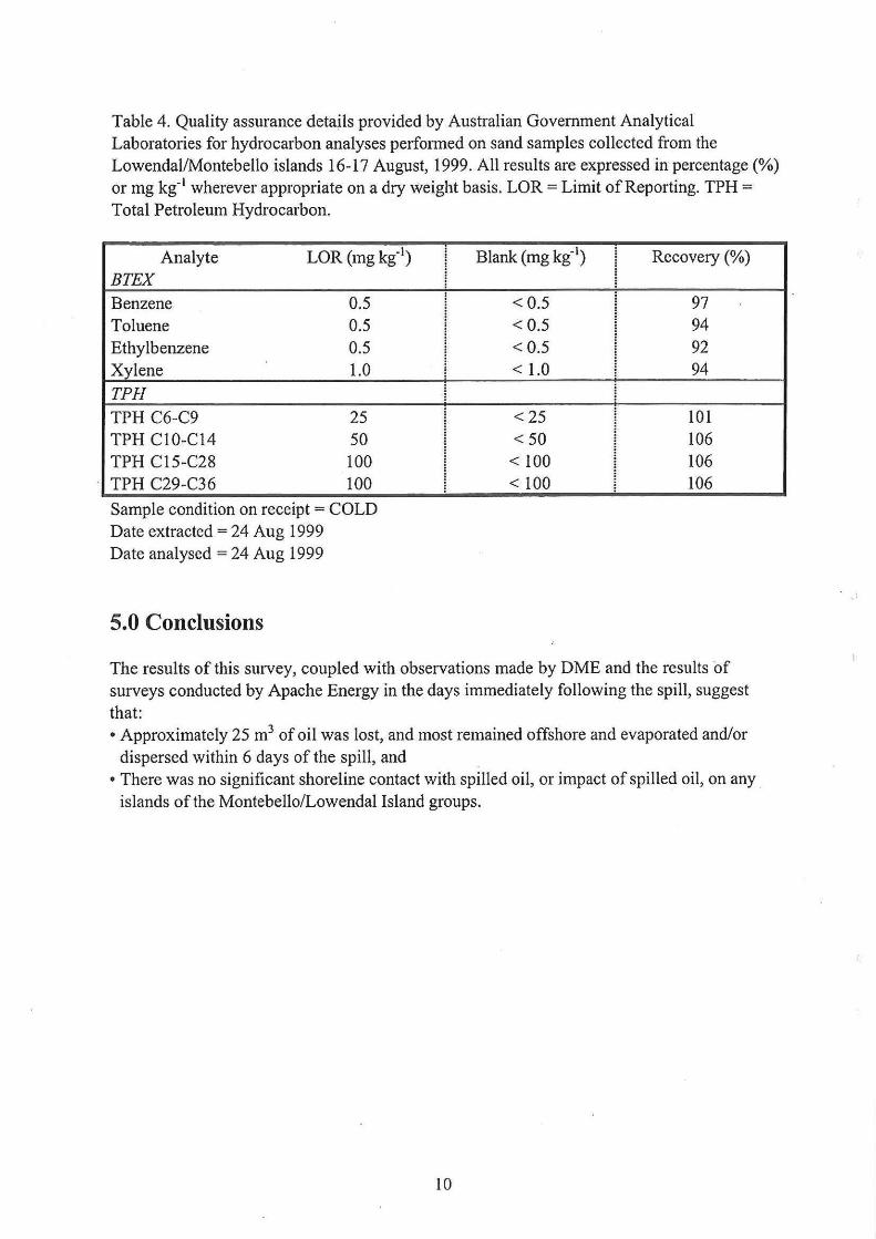
Table 4. Quality assurance details provided by Australian Government Analytical Laboratories for hydrocarbon analyses performed on sand samples collected from the Lowendal/Montebello islands 16-17 August, 1999. All results are expressed in percentage (%) or mg kg-1 wherever appropriate on a dry weight basis. LOR= Limit of Reporting. TPH = Total Petroleum Hydrocarbon.
Analyte LOR (mg kg-1)
BTEX Benzene 0.5 Toluene 0.5 Ethylbenzene 0.5 Xylene 1.0
TPH TPH C6-C9 25 TPH C10-C14 50 TPH C15-C28 100 TPH C29-C36 100
Sample condition on receipt = COLD Date extracted = 24 Aug 1999 Date analysed = 24 Aug 1999
5.0 Conclusions
: Blank (mg kg-1
) Recovery (%)
< 0.5 97 < 0.5 94 < 0.5 92 < 1.0 94
<25 101 <50 106
< 100 106 < 100 106
The results of this survey, coupled with observations made by DME and the results of surveys conducted by Apache Energy in the days immediately following the spill, suggest that: • Approximately 25 m3 of oil was lost, and most remained offshore and evaporated and/or
dispersed within 6 days of the spill, and • There was no significant shoreline contact with spilled oil, or impact of spilled oil, on any .
islands of the Montebello/Lowendal Island groups.
10
..