Embed Size (px)
Citation preview

TECHNICAL NOTE
Investigation of Damage in and Around Kathmandu ValleyRelated to the 2015 Gorkha, Nepal Earthquake and Beyond
Tsuneo Ohsumi . Yoichi Mukai . Hideo Fujitani
Received: 16 February 2016 / Accepted: 26 April 2016 / Published online: 9 May 2016
� The Author(s) 2016. This article is published with open access at Springerlink.com
Abstract An earthquake with a magnitude of 7.8
(Mw) occurred at 11:56 NST (local time) on 25 April
2015, in the central part of Nepal (Gorkha).We
organized a damage survey team and dispatched it to
the affected area for several periods following the
earthquake (May 26 to June 3: first trip, June 17 to 24:
second trip,August 16 to 21: third trip andOctober 27 to
November 2: forth trip) to investigate the damage and
collect data.We found traditional constructionmethods
are stronger than imagined. Many traditional earth-
quake-resistance technologies exist in Nepal. The first
and second surveys were to collect timely statistical
information on the damage to brick and stone masonry
buildings and to confirm the availability of data and
their sources for subsequent surveys. We also carried
out a first-hand building damage survey in selected
areas. The investigation of the strong-motion data set
from the USGS Center for Engineering Strong Motion
Data includes information from stations in Nepal that
continued to function throughout themain shock and the
several subsequent strong aftershocks of the 2015
earthquake. The third and fourth surveys were to collect
the every building damage survey in selected areas. The
motivation behind the surveywas to obtain ground truth
data for the calibration and improvement of a wide-area
damage estimation system that uses satellite data; the
system is currently under development by National
Research Institute for Earth Science and Disaster
Prevention (NEID) and the Japan Aerospace Explo-
ration Agency (JAXA). A survey of the degree of
damage was conducted for every house in Sankhu and
Khokana by the EuropeanMacroseismic Scale (EMS) -
98. This report outlines the findings of this investigation
team into various aspects of the earthquake disaster in
the Kathmandu Valley. The motivation behind the
surveywas toobtainground truth data for the calibration
and improvement of a wide-area damage estimation
system that uses satellite data. Field surveys confirmed
that the severely damaged urban area was well detected
by the decrease derived from the ALOS-2 satellite SAR
data. The higher classification accuracy for non-dam-
aged area helps to detect the damaged urban area using
this technique, immediately after a disaster.
Keywords Gorkha � Nepal earthquake �Kathmandu � Masonry � Ground truth
1 Introduction
An earthquake with a magnitude of 7.8 (Mw) occurred
at 11:56 Nepal Standard Time (NST), (local time) on
25 April 2015, in the central part of Nepal (Gorkha).
T. Ohsumi (&)
National Research Institute for Earth Science and Disaster
Resilience (NIED), Tennoudai 3-1, Tsukuba 305-0006,
Japan
e-mail: [email protected]
Y. Mukai � H. FujitaniKobe University, Rokkoudai 1-1, Nada, Kobe 657-8501,
Japan
123
Geotech Geol Eng (2016) 34:1223–1245
DOI 10.1007/s10706-016-0023-9
The epicenter was east-southeast of Lamjung, 77 km
south-west of Kathmandu, 28.15 at the north latitude
and 84.71 at the east longitude, and the depth was
15 km (USGS). According to the statistics by The
Nepal Police on 22 June the number of deaths 8660
and injured 21,952 for the main shock and deaths 172
and injured 3470 for the aftershock. It was also
reported that[5,000,000 buildings and houses were
damaged and about half those which of had collapsed.
This earthquake was officially named as The 2015
Gorkha, Nepal earthquake, since the hypocenter was
located in the Gorkha region.
A major aftershock with a moment magnitude of
7.3 (Mw) occurred at 12:51 NST on 12 May 2015. The
epicenter was 75 km north-east of Kathmandu and
near the Chinese border, 27.82 at the north latitude and
86.08 at the east longitude, and the depth was 19 km
(USGS).
We surveyed to the affected area during 26 May to
3 June and 17 to 24 to investigate the damage and
collect data. The findings of this investigation under-
taken by this team on the various aspects of the
earthquake disaster in the Kathmandu valley. Third
damage survey and fourth damage were conducted for
every house in Sankhu on 17–18 Aug/29 Oct 2015 and
in Khokana on 19–20 Aug/30–31 Oct 2015.
We found traditional construction methods are
stronger than imagined. Many traditional earthquake-
resistance technologies exist in Nepal. This is an
important factor in maintaining traditional construc-
tion methods to preserve such technologies.
The maintenance of traditional buildings con-
tributes not only to the maintenance of world heritage
but also improvements in the earthquake resistance of
cities. The problem of the masonry structure and in
maintenance is shown in this study.
Surveys of building types and damage extent were
conducted, for every house in Sankhu and Khokana,
Kathmandu, after a second survey term. For building
types, we used building classification surveys by the
Japan International Cooperation Agency, commonly
called JICA (2002). Building damage magnitudes
were classified using European Macroseismic Scale
(EMS)-98 (Grunthal 1998). A high-resolution image
fromMarch 12 (before the disaster) was obtained from
Google EarthTM prior to the survey. This image was
used to identify the position of each building before
the earthquake, based on which the damage to each
building was estimated in accordance with EMS-98.
With the above approach, we determined damage in
Sankhu and Khokana related to the 2015 Gorkha
Earthquake in core areas, using the damage function
indicated by JICA (2002) .
2 Earthquake Recorded in Kanti Path (Katnp),
Central Kathmandu
The strong-motion data set from the USGS Center for
Engineering Strong Motion Data (CESMD: http://
strongmotioncenter.org/cgi-bin/CESMD/iqr1.pl).
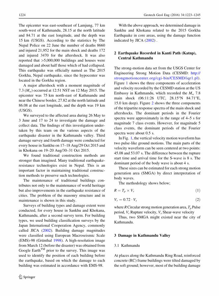
Figure 1 shows the three components of acceleration
and velocity recorded by the CESMD station at the US
Embassy in Kathmandu, which recorded the Mw 7.8
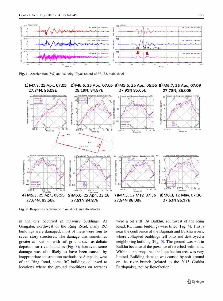
main shock (06:11:26 UTC, 28.15�N 84.71�E,15.0 km deep). Figure 2 shows the three components
of the tripartite response spectra of the main shock and
aftershocks. The dominant periods in the Fourier
spectra were approximately in the range of 4–5 s for
magnitude 7 class events. However, for magnitude 5
class events, the dominant periods of the Fourier
spectra were about 0.5 s.
In Fig. 1, the vertical velocity motionwaveform has
two pulse-like ground motions. The main parts of the
velocity waveform can be seen centered at two points:
45.08 and 53.07 s. The difference between the rupture
start time and arrival time for the S-wave is 8 s. The
dominant period of the body wave is about 4 s.
These sizes can be estimated for each strong motion
generation area (SMGA) by direct interpretation of
body waves.
The methodology shows below;
R ¼ Tp � Vr ð1Þ
Vr ¼ 0:72 � Vs ð2Þ
whereRCircular strongmotion generation area,TpPulse
period, Vr Rupture velocity, Vs Shear-wave velocity
Thus, two SMGA might existed near the city of
Kathmandu.
3 Damage in Kathmandu Valley
3.1 Kathmandu
At places along the Kathmandu Ring Road, reinforced
concrete (RC) frame buildings were tilted damaged by
the soft ground; however, most of the building damage
1224 Geotech Geol Eng (2016) 34:1223–1245
123
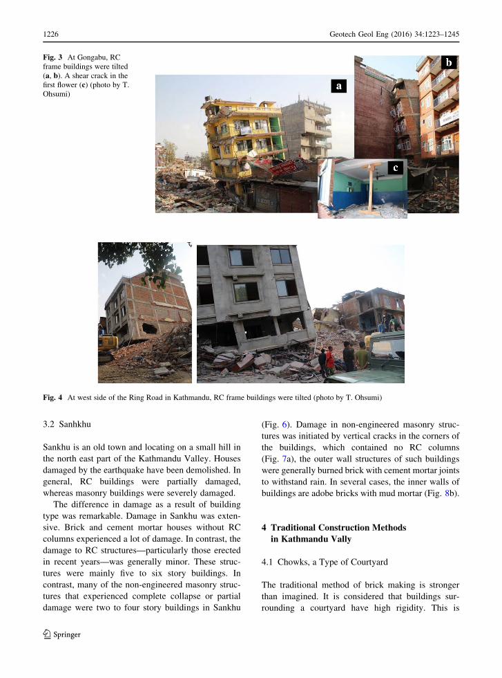
in the city occurred in masonry buildings. At
Gongabu, northwest of the Ring Road, many RC
buildings were damaged; most of these were four to
seven story structures. The damage was sometimes
greater at locations with soft ground such as deltaic
deposit near river branches (Fig. 3); however, some
damage was also likely to have been caused by
inappropriate construction methods. At Sitapaila, west
of the Ring Road, some RC building collapsed at
locations where the ground conditions on terraces
were a bit stiff. At Balkhu, southwest of the Ring
Road, RC frame buildings were tilted (Fig. 4). This is
near the confluence of the Bagmati and Balkhu rivers,
where collapsed buildings fell onto and destroyed a
neighboring building (Fig. 5). The ground was soft in
Balkhu because of the presence of riverbed sediments.
Within our survey area, the liquefaction area was very
limited. Building damage was caused by soft ground
on the river branch (related to the 2015 Gorkha
Earthquake), not by liquefaction.
Fig. 1 Acceleration (left) and velocity (light) record of Mw 7.8 main shock
Fig. 2 Response spectrum of main shock and aftershocks
Geotech Geol Eng (2016) 34:1223–1245 1225
123
3.2 Sanhkhu
Sankhu is an old town and locating on a small hill in
the north east part of the Kathmandu Valley. Houses
damaged by the earthquake have been demolished. In
general, RC buildings were partially damaged,
whereas masonry buildings were severely damaged.
The difference in damage as a result of building
type was remarkable. Damage in Sankhu was exten-
sive. Brick and cement mortar houses without RC
columns experienced a lot of damage. In contrast, the
damage to RC structures—particularly those erected
in recent years—was generally minor. These struc-
tures were mainly five to six story buildings. In
contrast, many of the non-engineered masonry struc-
tures that experienced complete collapse or partial
damage were two to four story buildings in Sankhu
(Fig. 6). Damage in non-engineered masonry struc-
tures was initiated by vertical cracks in the corners of
the buildings, which contained no RC columns
(Fig. 7a), the outer wall structures of such buildings
were generally burned brick with cement mortar joints
to withstand rain. In several cases, the inner walls of
buildings are adobe bricks with mud mortar (Fig. 8b).
4 Traditional Construction Methods
in Kathmandu Vally
4.1 Chowks, a Type of Courtyard
The traditional method of brick making is stronger
than imagined. It is considered that buildings sur-
rounding a courtyard have high rigidity. This is
Fig. 3 At Gongabu, RC
frame buildings were tilted
(a, b). A shear crack in the
first flower (c) (photo by T.
Ohsumi)
Fig. 4 At west side of the Ring Road in Kathmandu, RC frame buildings were tilted (photo by T. Ohsumi)
1226 Geotech Geol Eng (2016) 34:1223–1245
123

important to save the lost courtyard Fig. 8 shows
typical courtyard in Lalitpur and Bhaktapur.
A chowk is a type of courtyard that is common in
the community of Newar in Nepal. The chowk is
characterized by a square or rectangular space sur-
rounded by buildings on all sides. The surrounding
buildings are built on a raised platform, called falcha.
Opposite the main entrance on the ground floor is an
area dedicated to the Guthi—Social Unify and other
Gods with idols of deities. The chowk structure is
excellent with respect to earthquake resistance. How-
ever, these traditional buildings are gradually becom-
ing less common as a result of rebuilding (Fig. 9).
4.2 Typical Masonry Building Four-Story
Structures
In urban core areas, four-story buildings dominate, and
more than a third of the buildings are five stories or
higher. The construction of the Nepalese traditional
four-story house is shown in Fig. 10. These are mainly
brick masonry structures, but many of them have been
extended vertically by adding additional stories to the
original three- or three and a half-story buildings. In
addition, many of them are divided vertically for the
Fig. 5 At the branch point
of the Bagmati River and the
Transformor River,
collapsed building (a) fellonto and destroyed the next
building (b) (photo by T.
Ohsumi). OpenStreetMap
https://www.openstreetmap.
org/
Fig. 6 RC buildings were partially damaged, the difference
appears remarkable in Sankhu (photo by T. Ohsumi)Fig. 7 A vertical crack in a brick masonry wall was generated
from the corner (a). Structures having no RC columns on the
corner (b) (photo by T. Ohsumi)
Geotech Geol Eng (2016) 34:1223–1245 1227
123

use of separate families because of the local custom of
succession of property. This contributes to higher
seismic risk, even if one does not consider the poor
building technology actually adopted for the
construction.
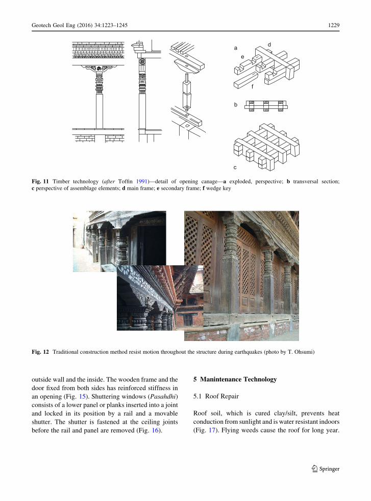
4.3 The Timber Repair
The traditional method of construction, which does not
use metal with timber (Fig. 11) has prevented degra-
dation for a long time. This type of construction should
be repaired using traditional methods without resort-
ing to modern methods. This traditional construction
method resist motion throughout the structure during
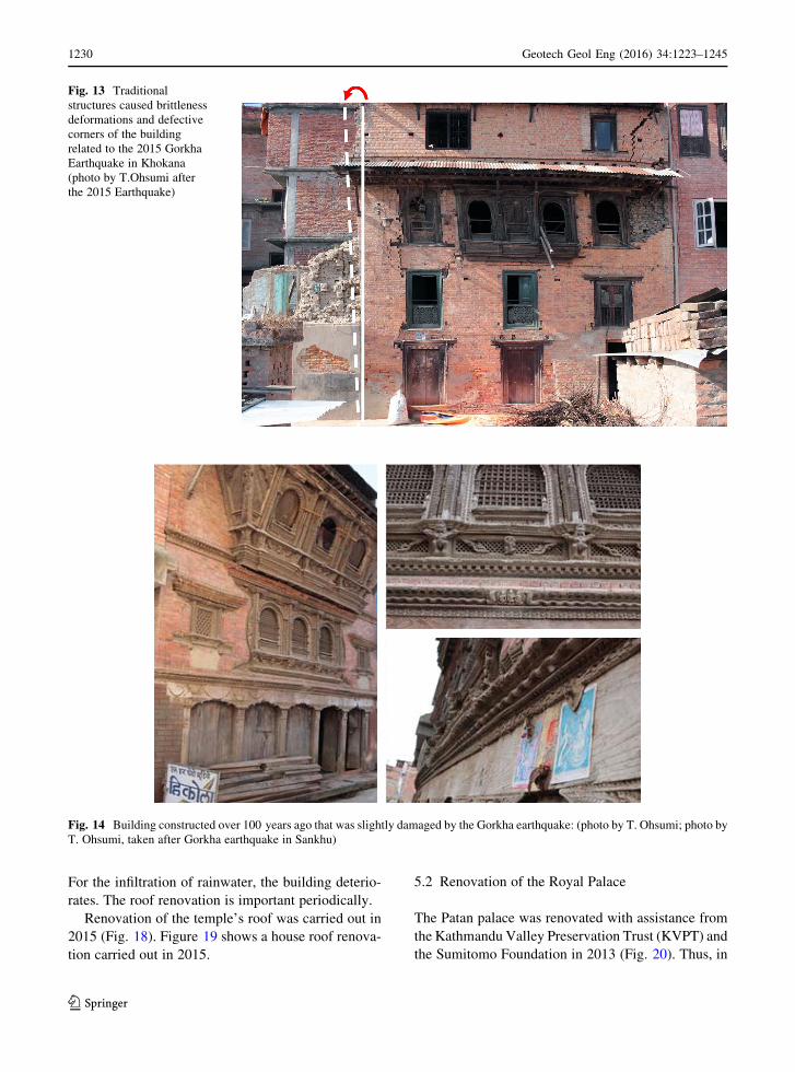
earthquakes (Fig. 12). The traditional structures
caused brittleness transformations and defective
corners of the structures related to the 2015 Gorkha
earthquake (Fig. 13). Reinforcement with such com-
ponents as hold down hardware and battledore bolts is
indispensable.
4.4 The Latticed Window and the Outer Frame
Effect
A latticed window and an outer frame (puratva)
surrounds door are reinforced the buildings (Fig. 14).
The window and the door made with a tree have its
own stiffness. The wooden frame is arranged with the
Fig. 8 Building with a
central courtyard/chowk in
Lalitpur (a photo taken in
2001), b courtyard/chowk
image
Fig. 9 Traditional buildings are gradually becoming less
common as a result of rebuilding (photo by T. Ohsumi, taken
after earthquake in Sankhu)
Fig. 10 Typical cross section of a multiple-story building (after
Toffin 1991)
1228 Geotech Geol Eng (2016) 34:1223–1245
123
outside wall and the inside. The wooden frame and the
door fixed from both sides has reinforced stiffness in
an opening (Fig. 15). Shuttering windows (Pasahdhi)
consists of a lower panel or planks inserted into a joint
and locked in its position by a rail and a movable
shutter. The shutter is fastened at the ceiling joints
before the rail and panel are removed (Fig. 16).
5 Manintenance Technology
5.1 Roof Repair
Roof soil, which is cured clay/silt, prevents heat
conduction from sunlight and is water resistant indoors
(Fig. 17). Flying weeds cause the roof for long year.
a d
e
f
b
c
Fig. 11 Timber technology (after Toffin 1991)—detail of opening canage—a exploded, perspective; b transversal section;
c perspective of assemblage elements; d main frame; e secondary frame; f wedge key
Fig. 12 Traditional construction method resist motion throughout the structure during earthquakes (photo by T. Ohsumi)
Geotech Geol Eng (2016) 34:1223–1245 1229
123
For the infiltration of rainwater, the building deterio-
rates. The roof renovation is important periodically.
Renovation of the temple’s roof was carried out in
2015 (Fig. 18). Figure 19 shows a house roof renova-
tion carried out in 2015.
5.2 Renovation of the Royal Palace
The Patan palace was renovated with assistance from
the Kathmandu Valley Preservation Trust (KVPT) and
the Sumitomo Foundation in 2013 (Fig. 20). Thus, in
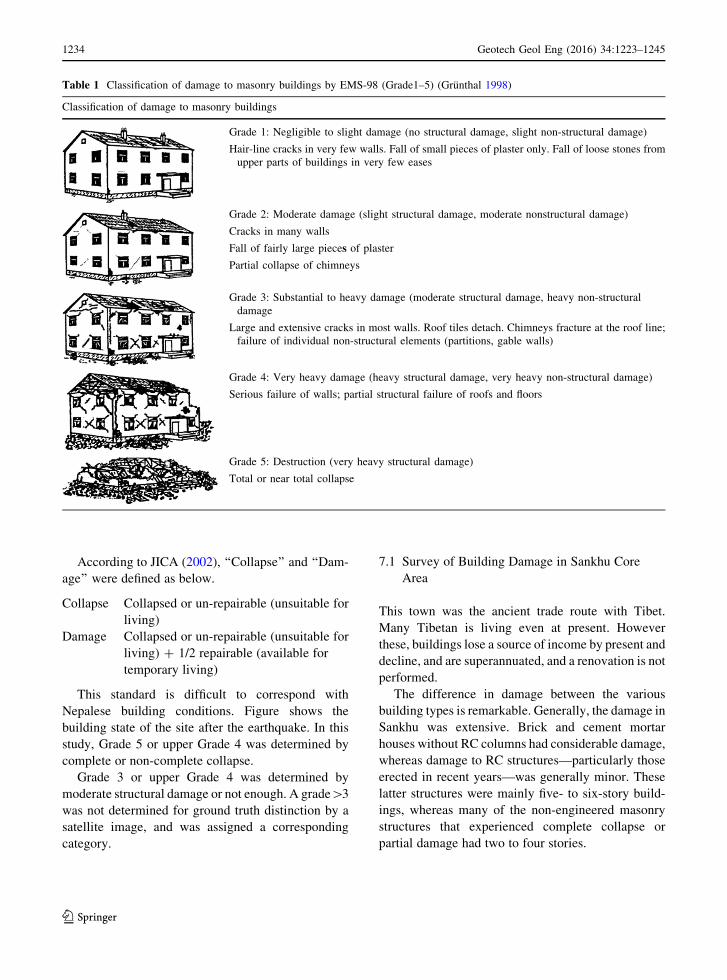
Fig. 14 Building constructed over 100 years ago that was slightly damaged by the Gorkha earthquake: (photo by T. Ohsumi; photo by
T. Ohsumi, taken after Gorkha earthquake in Sankhu)
Fig. 13 Traditional
structures caused brittleness
deformations and defective
corners of the building
related to the 2015 Gorkha
Earthquake in Khokana
(photo by T.Ohsumi after
the 2015 Earthquake)
1230 Geotech Geol Eng (2016) 34:1223–1245
123

Patan, after the earthquake, this palace had only partial
damage at the top of the structure (Gajur and
Baymvah).
6 Building Types in the Kathmandu Valley
Hazards and damage were analyzed in a study on
earthquake disaster mitigation in the Kathmandu
Valley (JICA 2002). To estimate damage to buildings
from the earthquake, a building inventory, especially
one with the distribution of buildings by structural
type, is necessary. Building structure types were
grouped into the following seven classes based on
the inventory.
ST Stone
AD Adobe
BM Brick with mud mortar, poorly built
BMW Brick with mud mortar, well built
BC Brick with cement or lime mortar
RC5 Reinforced concrete (RC) frame with
masonry of four stories or more
Fig. 15 Structural elements
of a window: a and
Section of a door: b details
of sill, lintel, door leaves and
bolts (after Gutschow
et al. 1987)
Fig. 16 Shuttering
window: a (photo by T.
Ohsumi) and section of a
shuttering window: b (after
Gutschow et al. 1987)
Geotech Geol Eng (2016) 34:1223–1245 1231
123

RC3 RC frame with masonry of three stories or
less
According to the inventory, we determined building
types and their distribution in the settlement types of
Kathmandu Valley. The main types are ST, AD, BM,
BC and RC. Newer types (BC and RC) are predom-
inant in the central and rapidly developing areas, and
other types (ST, AD and BM) are predominant in rural
or older core areas with dense population.
(a) RC
RC buildings have been constructed in the last 30 or
40 years in urban areas. Although most building
owners and constructors believe that RC buildings
are safer and sufficiently strong, most buildings were
designed without a structural engineer and were built
with supervision by unskilled craftsmen or masons
who had no fundamental practice or structural knowl-
edge of RC work. The initial plan including such items
as the size of columns and beams was probably for
three-story buildings, but current RC buildings extend
four to six stories without strengthening of columns
and beams. This may be attributed to rapid increase of
Fig. 17 Typical roof cross section. (courtesy of Assistant Prof.
Ram Prasad Suwal with Nepal Engineering College)
Fig. 18 Renovation of a temple’s roof was carried out in 2015 a installation of timber rafters, b hand wood planking (photo by T.
Ohsumi)
Fig. 19 Renovation of a house roof was carried out in 2015
(photo by T. Ohsumi)
1232 Geotech Geol Eng (2016) 34:1223–1245
123

the urban population. Walls of the widened floors are
supported by cantilever beams and are located outside
the RC frames. The latter case has particularly great
fragility in case of a great earthquake.
(b) BC and BM
BC buildings, also constructed in the past 30 or
40 years, comprise about half the buildings in the
valley. This type of building is still weak regarding
horizontal rigidity, owing to poor workmanship and
lack of structural consideration of the joints from wall
to wall, wall to wooden floor and roof, and non-
integration of the masonry wall itself. Although
buildings of this type that are less than four stories
are generally constructed with suitable workmanship
and adequate wall balance, those more than four
stories tall have great fragility during a powerful
earthquake.
BM buildings remain in urban and rural areas.
These buildings have very poor horizontal rigidity
because of low bond strength and strong absorption of
moisture in mud joints, wooden floors and roofs.
During a great earthquake, BM buildings of less than
three stories appear fragile and those of three or more
are even more fragile.
(c) AD and ST
AD and ST buildings have great fragility during a
moderate earthquake.
7 Classification of Damage to Masonry Buildings
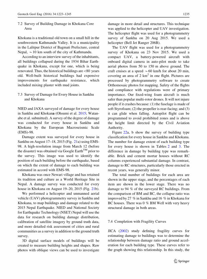
Table 1 shows EMS-98, which is the European
standard. According to this, Grades 1–5 are defined
below.
Grade 5 Very heavy structural damage
Grade 4 Very heavy structural and non-structural
damage
Grade 3 Moderate structural damage and heavy
non-structural damage
Grade 2 Slight structural damage and non-structural
damage
Grade 1 No structural damage and slight non-
structural damage
Fig. 20 Renovation of the structure and the covering of the roof
was carried out in 2011: a (top left) installation of timber rafters,
b hand wood planking, c waterproof membrane, d traditional
terracotta roof tiles on a mud bed (from information plate at the
Patan Museum)
Geotech Geol Eng (2016) 34:1223–1245 1233
123
According to JICA (2002), ‘‘Collapse’’ and ‘‘Dam-
age’’ were defined as below.
Collapse Collapsed or un-repairable (unsuitable for
living)
Damage Collapsed or un-repairable (unsuitable for
living) ? 1/2 repairable (available for
temporary living)
This standard is difficult to correspond with
Nepalese building conditions. Figure shows the
building state of the site after the earthquake. In this
study, Grade 5 or upper Grade 4 was determined by
complete or non-complete collapse.
Grade 3 or upper Grade 4 was determined by
moderate structural damage or not enough. A grade[3
was not determined for ground truth distinction by a
satellite image, and was assigned a corresponding
category.
7.1 Survey of Building Damage in Sankhu Core
Area
This town was the ancient trade route with Tibet.
Many Tibetan is living even at present. However
these, buildings lose a source of income by present and
decline, and are superannuated, and a renovation is not
performed.
The difference in damage between the various
building types is remarkable. Generally, the damage in
Sankhu was extensive. Brick and cement mortar
houses without RC columns had considerable damage,
whereas damage to RC structures—particularly those
erected in recent years—was generally minor. These
latter structures were mainly five- to six-story build-
ings, whereas many of the non-engineered masonry
structures that experienced complete collapse or
partial damage had two to four stories.
Table 1 Classification of damage to masonry buildings by EMS-98 (Grade1–5) (Grunthal 1998)
Classification of damage to masonry buildings
Grade 1: Negligible to slight damage (no structural damage, slight non-structural damage)
Hair-line cracks in very few walls. Fall of small pieces of plaster only. Fall of loose stones from
upper parts of buildings in very few eases
Grade 2: Moderate damage (slight structural damage, moderate nonstructural damage)
Cracks in many walls
Fall of fairly large pieces of plaster
Partial collapse of chimneys
Grade 3: Substantial to heavy damage (moderate structural damage, heavy non-structural
damage
Large and extensive cracks in most walls. Roof tiles detach. Chimneys fracture at the roof line;
failure of individual non-structural elements (partitions, gable walls)
Grade 4: Very heavy damage (heavy structural damage, very heavy non-structural damage)
Serious failure of walls; partial structural failure of roofs and floors
Grade 5: Destruction (very heavy structural damage)
Total or near total collapse
1234 Geotech Geol Eng (2016) 34:1223–1245
123
7.2 Survey of Building Damage in Khokana Core
Area
Khokana is a traditional old town on a small hill in the
southwestern Kathmandu Valley. It is a municipality
in the Lalitpur District of Bagmati Prefecture, central
Nepal, *10 km south of the city of Kathmandu.
According to an interview survey of the inhabitants,
all buildings collapsed during the 1934 Bihar Earth-
quake in Khokana, except for one, which is being
renovated. Thus, the historical buildings are\80 years
old. Well-built historical buildings had expensive
improvements for earthquake resistance, which
included mixing plaster with mud joints.
7.3 Survey of Damage for Every House in Sankhu
and Khokana
NIED and JAXA surveyed of damage for every house
in Sankhu and Khokana (Ohsumi et al. 2015; Watan-
abe et al. submitted). A survey of the degree of damage
was conducted for every house in Sankhu and
Khokana by the European Macroseismic Scale
(EMS)-98.
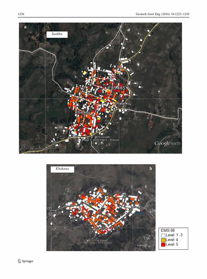
Damage extent was surveyed for every house in
Sankhu on August 17–18, 2015 (Fig. 21a) using EMS-
98. A high-resolution image from March 12 (before
the disaster) was obtained via Google EarthTM prior to
the survey. This image was used to identify the
position of each building before the earthquake, based
on which the extent of damage to each building was
estimated in accord with EMS-98.
Khokana was once Newari village and has retained
its tradition and culture as a World Heritage Site in
Nepal. A damage survey was conducted for every
house in Khokana on August 19–20, 2015 (Fig. 21b).
We performed a helicopter and unmanned aerial
vehicle (UAV) photogrammetry survey in Sankhu and
Khokana, to map buildings and damage related to the
2015 Nepal Earthquake. NIED and National Society
for Earthquake Technology (NSET) Nepal will use the
data for research on building damage distribution,
calibration of satellite imagery by ground truth data,
and more detailed risk assessment of cities and rural
communities as a survey in addition to the ground truth
survey.
3D digital surface models of buildings will be
created to measure building heights and shapes. Raw
photos with oblique views can be used to investigate
damage in more detail and structures. This technique
was applied to the helicopter and UAV investigation.
The helicopter flight was used for a photogrammetry
survey of Sankhu on 20 Aug 2015. We used a
helicopter (Bell Jet Ranger 206B).
The UAV flight was used for a photogrammetry
survey of Khokana on 23 Nov 2015. We used a
compact UAV, a battery-powered aircraft with
onboard digital camera in auto-pilot mode to take
aerial photos from 50 to 150 m above ground. The
craft cruises at a speed *60 km/h for about 20 min,
covering an area of 2 km2 in one flight. Pictures are
processed by photogrammetry software to create
Orthomosaic photos for mapping. Safety of the flights
and compliance with regulations were of primary
importance. Our fixed-wing foam aircraft is much
safer than popular multi-rotor drones. It will not injure
people if it crashes because: (1) the fuselage is made of
soft Styrofoam; (2) the propeller is rear-facing; and (3)
it can glide when falling. Autopilot flight can be
programmed to avoid prohibited zones and is above
the height limit directed by the Civil Aviation
Authority.
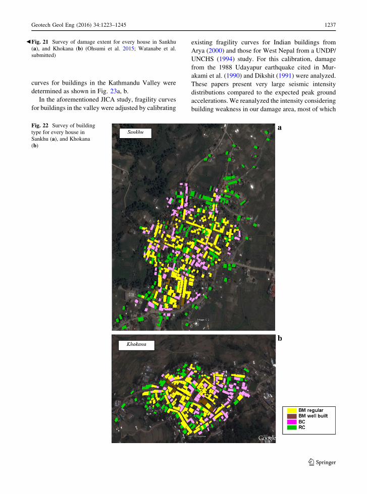
Figure 22a, b show the survey of building type
classification for every house in Sankhu and Khokana.
The number for damage extent of each building type
for every house is shown in Tables 2 and 3. The
difference in damage by building type was remark-
able. Brick and cement mortar houses without RC
columns experienced substantial damage. In contrast,
damage to RC structures, particularly those erected in
recent years, was generally minor.
The total number of buildings for each area are
shown in the upper stage, and the percentages of each
item are shown in the lower stage. There was no
damage to 94 % of the surveyed RC buildings. From
the comparison of BM and BC, the collapse ratio was
improved by 27 % in Sankhu and 16 % inKhokana for
BC houses. There was 0 % BM Well with very heavy
structural damage in both areas.
7.4 Completion with Fragility Curves
JICA (2002) study defining fragility curves for
estimating damage to buildings was to determine the
relationship between damage ratio and ground accel-
eration for each building type. These curves refer to
the graph showing this relationship. In this study, the
Geotech Geol Eng (2016) 34:1223–1245 1235
123
1236 Geotech Geol Eng (2016) 34:1223–1245
123
curves for buildings in the Kathmandu Valley were
determined as shown in Fig. 23a, b.
In the aforementioned JICA study, fragility curves
for buildings in the valley were adjusted by calibrating
existing fragility curves for Indian buildings from
Arya (2000) and those for West Nepal from a UNDP/
UNCHS (1994) study. For this calibration, damage
from the 1988 Udayapur earthquake cited in Mur-
akami et al. (1990) and Dikshit (1991) were analyzed.
These papers present very large seismic intensity
distributions compared to the expected peak ground
accelerations.We reanalyzed the intensity considering
building weakness in our damage area, most of which
bFig. 21 Survey of damage extent for every house in Sankhu
(a), and Khokana (b) (Ohsumi et al. 2015; Watanabe et al.
submitted)
Fig. 22 Survey of building
type for every house in
Sankhu (a), and Khokana
(b)
Geotech Geol Eng (2016) 34:1223–1245 1237
123
are AD or poor BM. Fragility curves of the relation-
ship between damage rate and peak ground acceler-
ation for each building type are shown in Fig. 23.
In the 2015 Gorkha Earthquake, there were no
acceleration observation points in Sankhu and Kho-
kana. The USGS maximum acceleration record was
160 Gal at the US embassy in the city of Kathmandu.
The distance between that embassy and Sankhu is
*15 km, and that between the embassy and Khokana
is *5 km. According to Takai et al. (2015), the main
shock in the observation results was 151 Gal at
Lalitpur and 146 Gal at Thimi. Estimation of main
Table 2 EMS level for
each ratio and building type
in Sankhu
EMS-level 1 EMS-level 2–3 EMS-level 4 EMS-level 5
RC 144 1 9 0
% 94 0 6 0
BC 76 5 23 15
% 64 4 19 13
BM well 9 3 2 0
% 64 22 14 0
BM 50 13 71 90
% 22 6 32 40
Table 3 EMS level for
each ratio and building type
in Khokana
EMS-level 1 EMS-level 2–3 EMS-level 4 EMS-level 5
RC 67 0 4 0
% 94 0 6 0
BC 54 0 17 2
% 74 0 23 3
BM well 7 0 4 0
% 64 0 36 0
BM 39 3 75 28
% 27 2 52 19
0
20
40
60
80
100
0 200 400 600
ST, AD BM
BMW, BCRC3
RC5
Damage rate150 Gal
0
20
40
60
80
100
0 200 400 600
ST, AD
BMBMW, BC
RC5
RC3
Collapse rate150 Gala b
Dam
age
rate
(%)
Dam
age
rate
(%)
PGA (gal) PGA (gal)
Fig. 23 Fragility curves of relation between damage rate and peak ground acceleration. a Damage rate, b Collapse rate
1238 Geotech Geol Eng (2016) 34:1223–1245
123

shock acceleration values was 150 Gal in Sankhu and
Khokana.
Damage ratio of RC is 7–8 % and damage ratio of
BM is the 20 %.
Graed 5, damage ratio of RC is 0 %, damage ratio
of BM is 40 %. In Khokana, damage ratio (Table 4) of
RC is 6 %, BM is 70 %. Collapse ratio of RC is 0 %,
BM is 20 %. The damage curved line of BM is
exceeded the damage curved line of ST, AD.
BM is composite structure including the sun-dried
brick (AD). The building classification is different in
ages and referred earthquakes (i.e., the 1934 Bihal
Earthquake, the 1988 Udayapur Earthquake).
The complicated composite structure is being
classified in BM by the damage function. On the other
hand, RC is actual damage rate and the damage
function rate are good agreement (Table 4).
7.5 SAR Analysis
In the severely damaged core area, the principal
mechanism of microwave radar backscattering
changes from double-bounce to rough-surface scat-
tering. This change corresponds to a decrease of
coherence (c) in synthetic aperture radar (SAR)
imagery observed before and after the disaster
(Fig. 24). The value of c represents the similarity
between two images. A decrease in c was determined
in the data obtained over Sankhu and Khokana by the
Japanese SAR satellite ALOS-2, and this was used
to delineate severely damaged urban areas. Field
surveys confirmed that damaged areas were effec-
tively detected by a decrease in c (Watanabe et al.
submitted).
Figure 25 shows the full view area as a Google
Earth image, including (a) the Timi, Bhaktapur and
Sankhu core areas, and (b) the Kirtipur, Khokana and
Bungamati core areas. The damaged core area is
identified using the coherence change (Dc) obtainedbefore the disaster (cpre) and between the disasters
(cint).Figure 26 shows regions of bright reflections within
severely damaged core areas such as Timi, Bhaktapur
and Sankhu. Figure 27 shows the coherence magni-
tude and a survey of damage extent for every house in
Sankhu. The decrease in coherence (c) in the SAR
imagery observed before and after the disaster readily
facilitated detection of damage in the region.
Figure 28 shows regions of bright reflections within
severely damaged core areas such as Khokana and
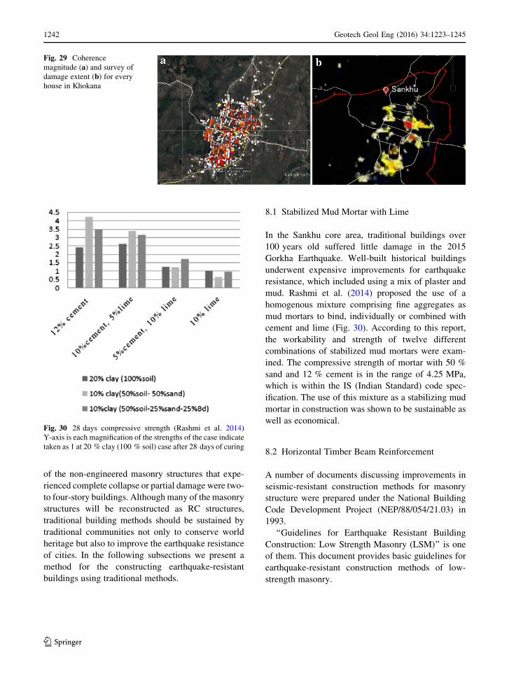
Bungamati. Figure 29 shows the coherence magnitude
Fig. 24 Whole interferogram obtained by the analysis. a Pre-
event, b Post-event
Table 4 Fragility curves
(JICA, 2002) and damage
and collapse rate
Damage rate Collapse rate
RC (%) BM (%) RC (%) BM (%)
Fragility curves
Estimation 7–8 20 5 17
Sankhu
Real damage 6 72 0 40
Khokana
Real damage 6 71 0 19
Geotech Geol Eng (2016) 34:1223–1245 1239
123
and a survey of damage extent for every house in
Khokana. Reflections in the slightly damaged Kirtipur
core area are not as clear and bright as those in the
severely damaged core areas of Khokana and
Bungamati.
7.5.1 Reason for Slight Damage at Kirtipur
The epicentral distance of the Kirtipur core area was
79.74 km, compared with 80.69 km for the epicentral
distance of the Khokana core area. Both core areas are
Fig. 25 Full view of the area as a Google Earth image,
including a the Timi, Bhaktapur and Sankhu core areas and b theKirtipur, Khokana and Bungamati core areas. The damaged core
area is detected using the coherence change (Dc) obtained beforethe disaster (cpre) and between the disasters (cint). Subscript
(pre2–pre1): Two coherences that were acquired from the
images before the disaster (cpre). Subscript (pre2-int): Two
coherences that were acquired from the images before the
disaster (cpre) and between the disasters (cint)
Fig. 26 Bright reflection
areas for severely damaged
urban area such as Timi,
Bhaktapur and Sankhu core
areas
1240 Geotech Geol Eng (2016) 34:1223–1245
123
old traditional towns on small hills in the southwestern
Kathmandu Valley. According to Takai et al. (2015),
acceleration was amplified in Patan (Khokana) located
in the Kathmandu Valley. In contrast, acceleration was
less amplified in Kirtipur, which is located on
outcropping basement rock units outside the valley.
8 After the 2015 Gorkha, Nepal Earthquake
and Beyound
The recovery and reconstruction processes following
the 2015 Gorkha, Nepal Earthquake are ongoing. The
damage to RC structures was generally minor. Many
Fig. 27 Coherence
magnitude (a) and survey of
damage extent (b) for everyhouse in Sankhu
Fig. 28 Bright reflection
areas for Khokana and
Bungamati core areas.
Kirtipur was not clear bright
reflection
Geotech Geol Eng (2016) 34:1223–1245 1241
123
of the non-engineered masonry structures that expe-
rienced complete collapse or partial damage were two-
to four-story buildings. Although many of the masonry
structures will be reconstructed as RC structures,
traditional building methods should be sustained by
traditional communities not only to conserve world
heritage but also to improve the earthquake resistance
of cities. In the following subsections we present a
method for the constructing earthquake-resistant
buildings using traditional methods.
8.1 Stabilized Mud Mortar with Lime
In the Sankhu core area, traditional buildings over
100 years old suffered little damage in the 2015
Gorkha Earthquake. Well-built historical buildings
underwent expensive improvements for earthquake
resistance, which included using a mix of plaster and
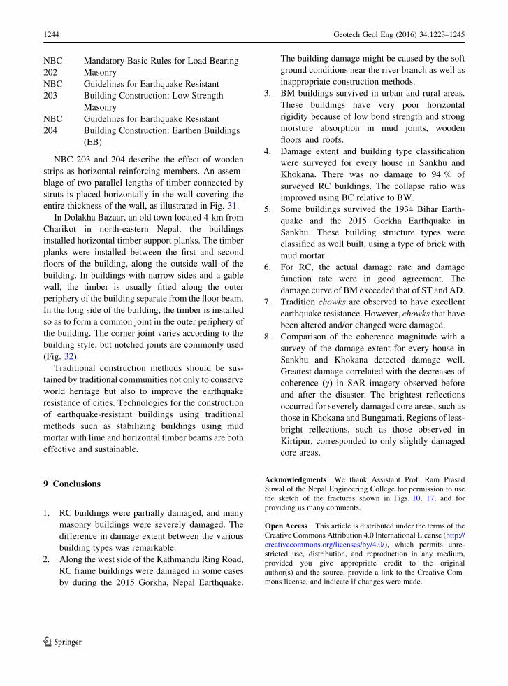
mud. Rashmi et al. (2014) proposed the use of a
homogenous mixture comprising fine aggregates as
mud mortars to bind, individually or combined with
cement and lime (Fig. 30). According to this report,
the workability and strength of twelve different
combinations of stabilized mud mortars were exam-
ined. The compressive strength of mortar with 50 %
sand and 12 % cement is in the range of 4.25 MPa,
which is within the IS (Indian Standard) code spec-
ification. The use of this mixture as a stabilizing mud
mortar in construction was shown to be sustainable as
well as economical.
8.2 Horizontal Timber Beam Reinforcement
A number of documents discussing improvements in
seismic-resistant construction methods for masonry
structure were prepared under the National Building
Code Development Project (NEP/88/054/21.03) in
1993.
‘‘Guidelines for Earthquake Resistant Building
Construction: Low Strength Masonry (LSM)’’ is one
of them. This document provides basic guidelines for
earthquake-resistant construction methods of low-
strength masonry.
Fig. 29 Coherence
magnitude (a) and survey of
damage extent (b) for everyhouse in Khokana
Fig. 30 28 days compressive strength (Rashmi et al. 2014)
Y-axis is each magnification of the strengths of the case indicate
taken as 1 at 20 % clay (100 % soil) case after 28 days of curing
1242 Geotech Geol Eng (2016) 34:1223–1245
123

Fig. 31 Placement of
timber for horizontal
reinforcement bands (after
National Building Code
NBC203). Wooden Collar
Beam with anchor bolt (a),Horizontal reinforcement
with liner (b), Two sawn
lumbers (c)
Fig. 32 Timber band installed between the first and second floors in a house in Charikot (a) and Corner joint of horizontal timber
planks (b). (Photos by Dr. Hiroshi Imai of the JICA study team)
Geotech Geol Eng (2016) 34:1223–1245 1243
123
NBC
202
Mandatory Basic Rules for Load Bearing
Masonry
NBC
203
Guidelines for Earthquake Resistant
Building Construction: Low Strength
Masonry
NBC
204
Guidelines for Earthquake Resistant
Building Construction: Earthen Buildings
(EB)
NBC 203 and 204 describe the effect of wooden
strips as horizontal reinforcing members. An assem-
blage of two parallel lengths of timber connected by
struts is placed horizontally in the wall covering the
entire thickness of the wall, as illustrated in Fig. 31.
In Dolakha Bazaar, an old town located 4 km from
Charikot in north-eastern Nepal, the buildings
installed horizontal timber support planks. The timber
planks were installed between the first and second
floors of the building, along the outside wall of the
building. In buildings with narrow sides and a gable
wall, the timber is usually fitted along the outer
periphery of the building separate from the floor beam.
In the long side of the building, the timber is installed
so as to form a common joint in the outer periphery of
the building. The corner joint varies according to the
building style, but notched joints are commonly used
(Fig. 32).
Traditional construction methods should be sus-
tained by traditional communities not only to conserve
world heritage but also to improve the earthquake
resistance of cities. Technologies for the construction
of earthquake-resistant buildings using traditional
methods such as stabilizing buildings using mud
mortar with lime and horizontal timber beams are both
effective and sustainable.
9 Conclusions
1. RC buildings were partially damaged, and many
masonry buildings were severely damaged. The
difference in damage extent between the various
building types was remarkable.
2. Along the west side of the Kathmandu Ring Road,
RC frame buildings were damaged in some cases
by during the 2015 Gorkha, Nepal Earthquake.
The building damage might be caused by the soft
ground conditions near the river branch as well as
inappropriate construction methods.
3. BM buildings survived in urban and rural areas.
These buildings have very poor horizontal
rigidity because of low bond strength and strong
moisture absorption in mud joints, wooden
floors and roofs.
4. Damage extent and building type classification
were surveyed for every house in Sankhu and
Khokana. There was no damage to 94 % of
surveyed RC buildings. The collapse ratio was
improved using BC relative to BW.
5. Some buildings survived the 1934 Bihar Earth-
quake and the 2015 Gorkha Earthquake in
Sankhu. These building structure types were
classified as well built, using a type of brick with
mud mortar.
6. For RC, the actual damage rate and damage
function rate were in good agreement. The
damage curve of BM exceeded that of ST and AD.
7. Tradition chowks are observed to have excellent
earthquake resistance. However, chowks that have
been altered and/or changed were damaged.
8. Comparison of the coherence magnitude with a
survey of the damage extent for every house in
Sankhu and Khokana detected damage well.
Greatest damage correlated with the decreases of
coherence (c) in SAR imagery observed before
and after the disaster. The brightest reflections
occurred for severely damaged core areas, such as
those in Khokana and Bungamati. Regions of less-
bright reflections, such as those observed in
Kirtipur, corresponded to only slightly damaged
core areas.
Acknowledgments We thank Assistant Prof. Ram Prasad
Suwal of the Nepal Engineering College for permission to use
the sketch of the fractures shown in Figs. 10, 17, and for
providing us many comments.
Open Access This article is distributed under the terms of the
Creative Commons Attribution 4.0 International License (http://
creativecommons.org/licenses/by/4.0/), which permits unre-
stricted use, distribution, and reproduction in any medium,
provided you give appropriate credit to the original
author(s) and the source, provide a link to the Creative Com-
mons license, and indicate if changes were made.
1244 Geotech Geol Eng (2016) 34:1223–1245
123
References
Arya A (2000) Non-engineered construction in developing
countries—an approach toward earthquake risk prediction.
In: Proceedings of 12th WCEE, No. 2824
Dikshit AM (1991) Geological effects and intensity distribution
of the Udayapur (Nepal) earthquake of August 20, 1988.
J NGS 7:1–17
Grunthal G (1998) European Macroseismic Scale 1998, in
Cahiers du Centre Europeen de Geodynamique et de
Seismologique, vol 15. Centre Europeen de Geodynamique
et de Seismologie, Luxembourg, p 101
Gutschow N, Kolver B, Shresthacarya I (1987) Newar towns
and buildings: an illustrated dictionary Newari-English
(Nepalica), p 293
JICA (2002) The study on earthquake disaster mitigation in the
Kathmandu Valley of Nepal. http://www.franceseisme.fr/
EMS98_Original_english.pdf
Murakami HO, Fujiwara TS, Kubo T (1990) Pattern of casualty
occurrence due to the 1988 Earthquake in the Nepal—India
Border Region, 9SEE-90. Roorkee 1(3):25–32
Ohsumi T, Imai T, Inoue H, Aoi S, Fujiwara H (2015) Investi-
gation of damage in and around Kathmandu valley related
to the 2015 Gorkha, Nepal earthquake report of the
National Research Institute for Earth Science and Disaster
Prevention, No. 404, March, 2015, pp 1–54
Rashmi S, Jagadish KS, Nethravathi S (2014) Stabilized mud
mortar. Int J Res Eng Technol 3(Special Issue):233–239
Takai N, Sigefuji M, Bijukchhen S, Ichiyanagi M, Sasatani T
(2015) Storong motion of the Gorkha Earthquake Nepal
earthquake. Bull JAEE 26:2–5
Toffin G (1991) Man and his house in the Himalayas. Sterling
Publishers Private Limited, New Delhi, pp 95–107
ISBN8120713648UNDP/UNCHS (1994) The development of alternative building
materials and technologies for Nepal. His Majesty’s
Government of Nepal Ministry of Housing and Physical
Planning, UNDP/UNCHS (Habitat) SubprojectNEP/88/
054/21.03, Appendix C—seismic vulnerability analysis,
BECA, TAEC, SILT, URR
Watanabe M, Thapa RB, Ohsumi T, Yonezawa C, Tomii N,
Suzuki S (2015) Detection of damaged urban area by using
interferometric SAR coherence change with PALSAR-2.
Earth Planets Space (submitted)
Geotech Geol Eng (2016) 34:1223–1245 1245
123