Embed Size (px)
Citation preview
HAL Id: ujm-01620562https://hal-ujm.archives-ouvertes.fr/ujm-01620562
Submitted on 20 Oct 2017
HAL is a multi-disciplinary open accessarchive for the deposit and dissemination of sci-entific research documents, whether they are pub-lished or not. The documents may come fromteaching and research institutions in France orabroad, or from public or private research centers.
L’archive ouverte pluridisciplinaire HAL, estdestinée au dépôt et à la diffusion de documentsscientifiques de niveau recherche, publiés ou non,émanant des établissements d’enseignement et derecherche français ou étrangers, des laboratoirespublics ou privés.
Investigating the impact of two decades of urbanizationon the water balance of the Yzeron peri-urban
catchment, FranceF. Branger, S. Kermadi, P. Krause, M. Labbas, C. Jacqueminet, K Michel,
Isabelle Braud, S. Kralisch
To cite this version:F. Branger, S. Kermadi, P. Krause, M. Labbas, C. Jacqueminet, et al.. Investigating the impactof two decades of urbanization on the water balance of the Yzeron peri-urban catchment, France.International Congress on Environmental Modelling and Software Managing Resources of a LimitedPlanet, 2012, Leipzig, Germany. �ujm-01620562�
International Environmental Modelling and Software Society (iEMSs) 2012 International Congress on Environmental Modelling and Software
Managing Resources of a Limited Planet, Sixth Biennial Meeting, Leipzig, GermanyR. Seppelt, A.A. Voinov, S. Lange, D. Bankamp (Eds.)
http://www.iemss.org/society/index.php/iemss-2012-proceedings
Investigating the impact of two decades of urbanization on the water balance of the
Yzeron peri-urban catchment, France.
F. Branger 1 , S. Kermadi2, P. Krause3, M. Labbas1, C. Jacqueminet2, K. Michel2, I. Braud1, S. Kralisch4
1. IRSTEA, UR HHLY (Hydrology – Hydraulics), France, [email protected]. University of Lyon, UMR CNRS 5600 EVS, France
3. Thüringer Landesanstalt für Umwelt und Geologie (TLUG), Germany4. Department of Geoinformatic, Geohydrology and Modelling, Friedrich Schiller
University Jena, Germany
Abstract: This paper addresses the impact of 18 years of urbanization (1990-2008) on the Yzeron meso-scale peri-urban catchment (150 km²), located close to Lyon, France. A simplified version of the distributed hydrological model J2000 was used to perform long term simulations at a daily time step for several land use scenarios. These scenarios were derived from satellite SPOT images from years 1990, 1999 and 2008. The corresponding land use maps were classified into 5 classes depending on the percentage of impervious surfaces and the dominant non-impervious land use (agriculture or forest). The paper presents the methodology for the model setup and the simulation results for the main water balance components of the catchment: total runoff, runoff components, evapotranspiration and soil moisture. The results highlight the change of the catchment seasonal response from 1990 to 2008, mainly due to a change of the respective contributions of groundwater flow / surface runoff (+ 92% / - 28%, respectively). Monthly mean summer discharge unexpectedly appears to be higher in summer. It is provided by intermittent surface runoff generated by summer storm events. As surface runoff generated on urban surfaces is likely to carry a wide range of contaminants, this has a potential large impact on water quality.
Keywords: hydrological modelling; land use change; water balance, J2000, JAMS, Yzeron, France.
1 INTRODUCTION
Urban growth and concentration of population in urban areas is a general trend. 68.7% of the world population (94.1% in France) will live in urban areas by 2050 according to the UNO 2009 world urbanization prospect. In terms of water resources, the impact of land use change, extension of impermeable surfaces and introduction of artificial drainage networks may potentially lead to both more frequent floods and more frequent and longer drought periods, along with related water quality and ecological issues. The assessment of this impact on medium to large size catchments is a key issue for local stakeholders. In particular, in the context of the Water Framework Directive, they have to implement adequate policies and provide solutions at such spatial scales and for long time periods. The literature review shows that impact of urbanization on floods has been quite extensively investigated [Jacobson, 2011], whereas the long-term water balance is not that much studied [Claessens et al., 2006]. In particular, few long-term land use change studies address specifically peri-urban catchments, which are characterized by a high degree of heterogeneity with a mixture of natural, agricultural and
F. Branger et al. / Investigating the impact of two decades of urbanization on the water balance of the Yzeron peri-urban catchment, France.
urbanized areas and are evolving quickly [Miller et al., 2002, Choi and Deal, 2008, Im et al., 2009].The objective of the present study is to investigate the impact of urban growth on the hydrological balance of a peri-urban meso-scale catchment located close to Lyon, France, using remote sensing images and a simplified distributed hydrological model.
2 MATERIALS AND METHODS
2.1 Application site and available data
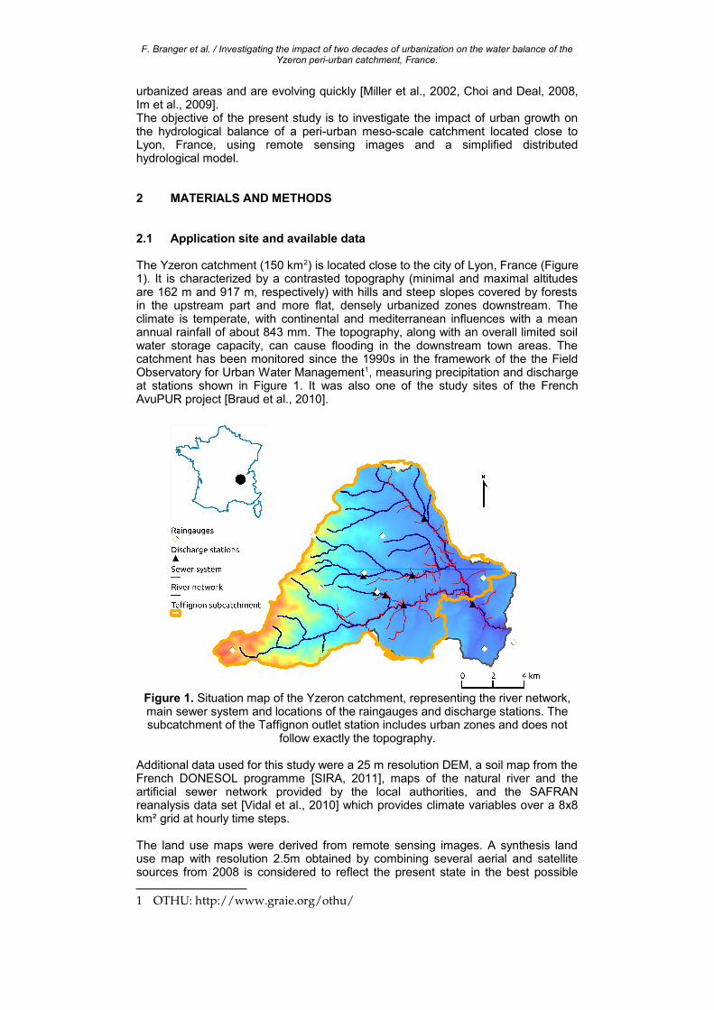
The Yzeron catchment (150 km2) is located close to the city of Lyon, France (Figure 1). It is characterized by a contrasted topography (minimal and maximal altitudes are 162 m and 917 m, respectively) with hills and steep slopes covered by forests in the upstream part and more flat, densely urbanized zones downstream. The climate is temperate, with continental and mediterranean influences with a mean annual rainfall of about 843 mm. The topography, along with an overall limited soil water storage capacity, can cause flooding in the downstream town areas. The catchment has been monitored since the 1990s in the framework of the the Field Observatory for Urban Water Management1, measuring precipitation and discharge at stations shown in Figure 1. It was also one of the study sites of the French AvuPUR project [Braud et al., 2010].
Figure 1. Situation map of the Yzeron catchment, representing the river network, main sewer system and locations of the raingauges and discharge stations. The subcatchment of the Taffignon outlet station includes urban zones and does not
follow exactly the topography.
Additional data used for this study were a 25 m resolution DEM, a soil map from the French DONESOL programme [SIRA, 2011], maps of the natural river and the artificial sewer network provided by the local authorities, and the SAFRAN reanalysis data set [Vidal et al., 2010] which provides climate variables over a 8x8 km² grid at hourly time steps.
The land use maps were derived from remote sensing images. A synthesis land use map with resolution 2.5m obtained by combining several aerial and satellite sources from 2008 is considered to reflect the present state in the best possible
1 OTHU: http://www.graie.org/othu/
F. Branger et al. / Investigating the impact of two decades of urbanization on the water balance of the Yzeron peri-urban catchment, France.
way [Jacqueminet et al., 2012]. Historical land use maps were obtained from satellite SPOT images for 1990, 1999 and 2008 [Kermadi et al., 2011], all resampled at 10 m resolution.
2.2 Model presentation
The model used in this study is the distributed hydrological model J2000 [Krause et al., 2006], available through the JAMS2 modelling framework [Kralisch et al., 2007]. J2000 simulates hydrological processes based on Hydrological Response Units (HRUs), using conceptual and physically-based approaches for simulation of interception, runoff / infiltration partition, evapotranspiration, soil percolation, groundwater flow and routing through the hydrographic network. J2000 was developed for long-term continuous modelling of meso- and macro-scale catchments. Compared to its original version, J2000 was slightly simplified to adapt to the local context and data availability. The snow component was removed as well as the potential evapotranspiration calculation component. Instead, the model was fed directly with potential evapotranspiration data calculated from SAFRAN, following FAO [1998]. Additionally, one of the two groundwater storages was also deactivated.
2.3 Model setup
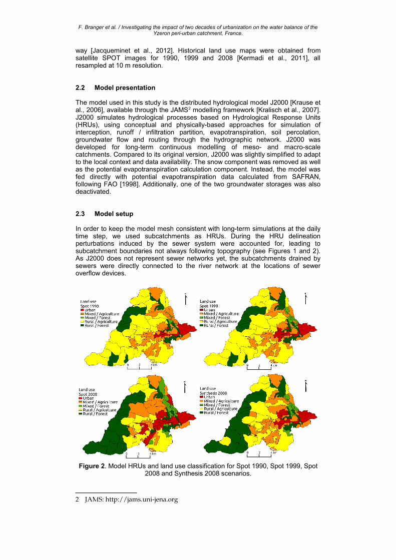
In order to keep the model mesh consistent with long-term simulations at the daily time step, we used subcatchments as HRUs. During the HRU delineation perturbations induced by the sewer system were accounted for, leading to subcatchment boundaries not always following topography (see Figures 1 and 2). As J2000 does not represent sewer networks yet, the subcatchments drained by sewers were directly connected to the river network at the locations of sewer overflow devices.
Figure 2. Model HRUs and land use classification for Spot 1990, Spot 1999, Spot 2008 and Synthesis 2008 scenarios.
2 JAMS: http://jams.unijena.org
F. Branger et al. / Investigating the impact of two decades of urbanization on the water balance of the Yzeron peri-urban catchment, France.
Land use was re-classified into 5 classes, using the same method for all maps. The original maps contained various classes, which were classified in Impervious (buildings and roads), Agriculture (pastures, low vegetation, ploughed soils), and Forest (deciduous trees and conifers) classes. HRUs were classified as Urban if more than 50% of land use was Impervious, Mixed if Impervious ranked between 10% and 50%, and Rural if less than 10%. Within classes Mixed and Rural, subclasses Agriculture and Forest were distinguished, depending on the dominant non-impervious land use. The resulting HRUs are displayed in Figure 2. Average vegetation parameters (leaf area index, crop coefficient, root depth) were set for each class according to FAO [1998] and Ecoclimap database [Masson et al., 2003]. As a first approximation, each land use class was assigned a runoff coefficient equal to the average percentage of impervious land use within the class for a given scenario. Figure 2 shows that between 1990 and 1999, the catchment experienced mainly a densification of existing urbanized zones, and a slight shift of dominant vegetation from agriculture to forest in mixed catchments. Between 1999 and 2008, changes were more important and consist mainly in an overall extension of urbanization, along with the progress of forest in the rural upstream zones. Overall, the percentage of impervious surfaces increased from 10% to 19% between 1990 and 2008, forests increased from 32% to 37% and agriculture decreased from 58% to 44%.
Simulations were run at a daily time step using 12-year climatic forcing time series (1998-2009, using year 1997 as the warm up period) for each of the four land use scenarios. In order to maintain an explicit link between the parameter values and the available data and not to compensate for changes potentially linked to the evolving land use, no calibration was undertaken. J2000's calibration parameters were thus set to neutral values. In order to estimate the model's ability to capture the most important hydrological processes within the catchment, the simulation results for the Synthesis 2008 reference scenario were first compared to discharge observations for the corresponding period (2005-2009). Then, the results over the whole simulation period were analysed for the 3 historical land use scenarios (SPOT 1990, 1999, 2008). The Synthesis 2008 scenario was not included in this analysis in order to avoid an interpretation bias due to image resolution.
3 RESULTS AND DISCUSSION
3.1 Model verification
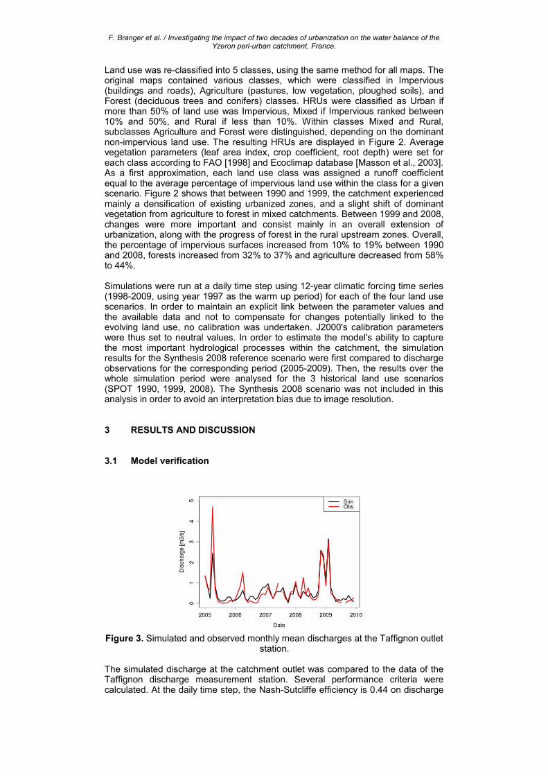
Figure 3. Simulated and observed monthly mean discharges at the Taffignon outlet station.
The simulated discharge at the catchment outlet was compared to the data of the Taffignon discharge measurement station. Several performance criteria were calculated. At the daily time step, the Nash-Sutcliffe efficiency is 0.44 on discharge
F. Branger et al. / Investigating the impact of two decades of urbanization on the water balance of the Yzeron peri-urban catchment, France.
and 0.61 on the square root of discharge, which gives less weight to the peak flow values. The model simulates the low flow values quite well , including the seasonal variations of base flow, whereas it reproduces the peak flow values less efficiently. It was found that the model tends mostly to overestimate peak flows for small events (discharge < 1 m3s-1). A possible explanation for this behaviour could be the model's simplified representation of drainage networks by connecting discharge from sewer-drained HRUs directly to the river. In the real world, this water would partly remain in the sewer network and be diverted towards the Waste Water Treatment Plant, and thus not contribute to river discharge. This will be quantified in more detail in future studies. The assumption of a runoff coefficient equal to the percentage of impervious areas should also be revisited.
The simulated and observed monthly mean discharges are quite in good agreement as represented on Figure 3, with a Nash-Sutcliffe efficiency of 0.78. The model bias for the 2005-2009 period is -2.07% and absolute bias 62.25%. Keeping in mind that the model was not calibrated, these results are quite acceptable. They show that, although not perfect, the model is able to represent the dominating processes involved in the catchment long-term water balance with a sufficient degree of accuracy.
3.2 Influence of land use change
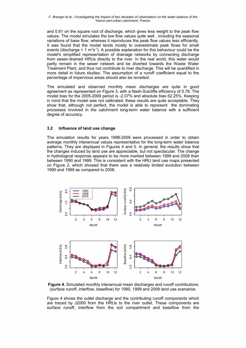
The simulation results for years 1998-2009 were processed in order to obtain average monthly interannual values representative for the long-term water balance patterns. They are displayed in Figures 4 and 5. In general, the results show that the changes induced by land use are appreciable, but not spectacular. The change in hydrological response appears to be more marked between 1999 and 2008 than between 1990 and 1999. This is consistent with the HRU land use maps presented on Figure 2, which showed that there was a relatively limited evolution between 1990 and 1999 as compared to 2008.
Figure 4. Simulated monthly interannual mean discharges and runoff contributions (surface runoff, interflow, baseflow) for 1990, 1999 and 2008 land use scenarios.
Figure 4 shows the outlet discharge and the contributing runoff components which are traced by J2000 from the HRUs to the river outlet. These components are surface runoff, interflow from the soil compartment and baseflow from the
F. Branger et al. / Investigating the impact of two decades of urbanization on the water balance of the Yzeron peri-urban catchment, France.
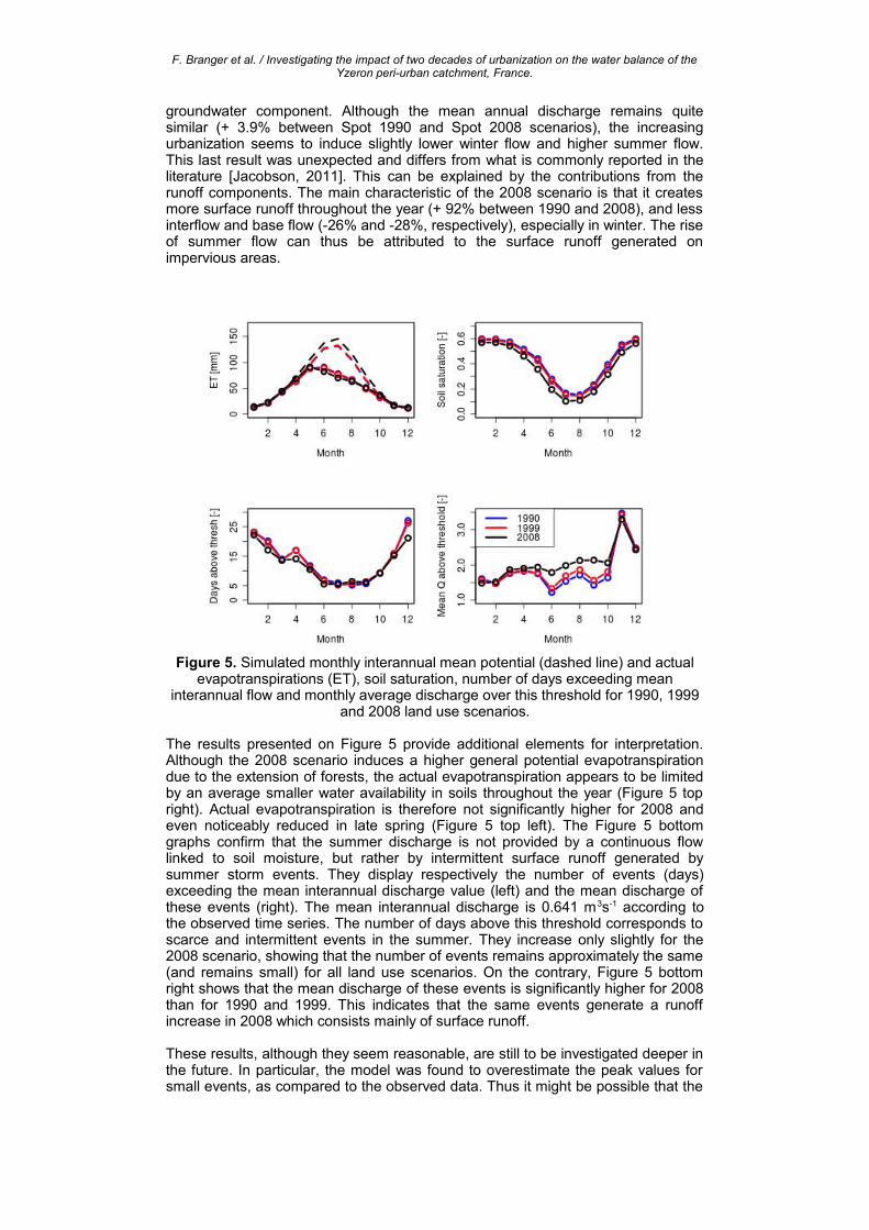
groundwater component. Although the mean annual discharge remains quite similar (+ 3.9% between Spot 1990 and Spot 2008 scenarios), the increasing urbanization seems to induce slightly lower winter flow and higher summer flow. This last result was unexpected and differs from what is commonly reported in the literature [Jacobson, 2011]. This can be explained by the contributions from the runoff components. The main characteristic of the 2008 scenario is that it creates more surface runoff throughout the year (+ 92% between 1990 and 2008), and less interflow and base flow (-26% and -28%, respectively), especially in winter. The rise of summer flow can thus be attributed to the surface runoff generated on impervious areas.
Figure 5. Simulated monthly interannual mean potential (dashed line) and actual evapotranspirations (ET), soil saturation, number of days exceeding mean
interannual flow and monthly average discharge over this threshold for 1990, 1999 and 2008 land use scenarios.
The results presented on Figure 5 provide additional elements for interpretation. Although the 2008 scenario induces a higher general potential evapotranspiration due to the extension of forests, the actual evapotranspiration appears to be limited by an average smaller water availability in soils throughout the year (Figure 5 top right). Actual evapotranspiration is therefore not significantly higher for 2008 and even noticeably reduced in late spring (Figure 5 top left). The Figure 5 bottom graphs confirm that the summer discharge is not provided by a continuous flow linked to soil moisture, but rather by intermittent surface runoff generated by summer storm events. They display respectively the number of events (days) exceeding the mean interannual discharge value (left) and the mean discharge of these events (right). The mean interannual discharge is 0.641 m3s-1 according to the observed time series. The number of days above this threshold corresponds to scarce and intermittent events in the summer. They increase only slightly for the 2008 scenario, showing that the number of events remains approximately the same (and remains small) for all land use scenarios. On the contrary, Figure 5 bottom right shows that the mean discharge of these events is significantly higher for 2008 than for 1990 and 1999. This indicates that the same events generate a runoff increase in 2008 which consists mainly of surface runoff.
These results, although they seem reasonable, are still to be investigated deeper in the future. In particular, the model was found to overestimate the peak values for small events, as compared to the observed data. Thus it might be possible that the
F. Branger et al. / Investigating the impact of two decades of urbanization on the water balance of the Yzeron peri-urban catchment, France.
influence of summer events as shown here is artificially enlarged by the model and does not necessarily correspond to effective hydrological processes. Nevertheless, the results highlight a change of the respective contributions of groundwater flow and surface runoff from 1990 to 2008. Surface runoff generated on urban surfaces is likely to carry a wide range of contaminants, all the more that it is mixed with waste water through the sewer network as it is the case for the Yzeron catchment. Therefore, the impact on water quality and stream health is particularly important, especially in summer when the river's main water providers happen to be the sewers.
4 CONCLUSION AND PERPSECTIVES
This study confirmed the potential of using the J2000 distributed model for assessing the impact of urbanization on the water balance components of the Yzeron catchment. The model adaptation to our application case was quite straightforward thanks to the JAMS framework. The results show that although the mean discharge at the catchment outlet is only slightly modified, the shift of contributions from the various flow components is more important and may lead to water quality problems.
Yet this is only a preliminary study, which must be confirmed and extended in two directions. The first direction would be to further validate and precise these results, in particular by using the available observation data on the catchment. A more detailed insight into the model behaviour could be provided by comparing simulation results with measurements at the intermediate discharge stations, which drain subcatchments with contrasted land uses. A comparison should also be done with results and conclusions based on the analysis of observed data.In the long term, the second direction is a further enhancement of the J2000 model in terms of process representation and spatial discretization to better take into account the peri-urban characteristics of the catchment. In particular, an accurate representation not only of the surface land use patterns but also of the artificial draining system, would allow to better represent historic conditions and to create robust and reliable projections of future development.
ACKNOWLEDGMENTS
The AVuPUR project was funded by the French National Research Agency (ANR) (contract ANR-07-VULN-01). CCVL, IGN, Grand Lyon, Météo-France, SAGYRC, SIAVHY, Sol-Info Rhône-Alpes provided data used in the study. SPOT images were acquired thanks to an ISIS contract.
REFERENCES
Braud, I.; Chancibault, K.; Debionne, S.; Lipeme Kouyi, G.; Sarrazin, B.; Jacqueminet, C.; Andrieu, H.; Béal, D.; Bocher, E.; Boutaghane, H.; Branger, F.; Breil, P.; Chocat, B.; Comby, J.; Dehotin, J.; Dramais, G.; Furusho, C.; Gagnage, M.; Gonzalez-Sosa, E.; Grosprêtre, L.; Honegger, A.; Jankowfsky, S.; Joliveau, T.; Kermadi, S.; Lagouy, M.; Leblois, E.; Martin, J.-Y.; Mazagol, P.-O.; Michel, K.; Molines, N.; Mosini, M.-L.; Puech, C.; Renard, F.; Rodriguez, F.; Schmitt, L.; Thollet, F. and Viallet, P.,The AVuPUR project (Assessing the Vulnerability of Peri-Urban Rivers): experimental setup, modelling strategy and first results, Proceedings of the 7th Novatech 2010 Conference', June 28-July 1st 2010, Lyon, France, 10pp, http://hal.archives-ouvertes.fr/hal-00527564_v1/, 2010.
Choi, W. and Deal, B., Assessing hydrological impact of potential land use change through hydrological and land use change modeling for the Kishwaukee River basin (USA), Journal of Environmental Management, 88(4), 1119-1130, 2008.
F. Branger et al. / Investigating the impact of two decades of urbanization on the water balance of the Yzeron peri-urban catchment, France.
Claessens, L.; Hopkinson, C.; Rastetter, E. and Vallino, J., Effect of historical changes in land use and climate on the water budget of an urbanizing watershed, Water Resources Research, 42(3) W03426, 2006.
FAO, Crop Evaporation - Guidelines for computing crop water requirements. Irrigation and Drainage paper n°56, FAO, Rome, 1998.
Im, S.; Kim, H.; Kim, C. and Jang, C., Assessing the impacts of land use changes on watershed hydrology using MIKE SHE, Environmental Geology, 57, 231-239, 2009.
Jacobson, C., Identification and quantification of the hydrological impacts of imperviousness in urban catchments: A review, Journal of Environmental Management, 92(6), 1438-1448, 2011.
Jacqueminet, C., Kermadi, S., Michel, K., Béal, D., Gagnage, M., Branger, F., Jankowfsky, S., and Braud, I., Land cover mapping using aerial and VHR satellite images for distributed hydrological modelling of periurban catchments: application to the Yzeron catchment (Lyon, France), Journal of Hydrology, Periurban catchments special issue, in revision, 2012.
Kermadi, S.; Braud, I.; Jacqueminet, C.; Michel, K. and Branger, F., Evolution de la pluviométrie dans le bassin péri-urbain de l’Yzeron (Ouest Lyonnais) depuis les années 1970 et caractérisation de l’imperméabilisation, Actes du XXIVème Colloque de l’Association Internationale de Climatologie, 6-11 Septembre 2011, Rovereto (Italy), 6pp, 2011.
Kralisch, S.; Krause, P.; Fink, M.; Fischer, C. and Flügel, W.-A, Component based environmental modelling using the JAMS framework, in L. Oxley & D. Kulasiri, Eds., MODSIM 2007 International Congress on Modelling and Simulation, pp. 812-818, 2007.
Krause, P.; Bäse, F.; Bende-Michl, U.; Fink, M.; Flügel, W. and Pfenning, B., Multiscale investigations in a mesoscale catchment - hydrological modelling in the Gera catchment, Advances in Geosciences, 9, 53-61, 2006.
Masson, V., Champeaux, J.L., Chauvin, F., Meriguet, C., and Lacaze, R., A global database of land surface parameters at 1-km resolutionin meteorological and climate models, Journal of Climate, 16(9), 1261-1282, 2003.
Miller, S.; Kepner, W.; Mehaffey, M.; Hernandez, M.; Miller, R.; Goodrich, D.; Devonald, K.; Heggem, D. and Miller, W., Integrating landscape assessment and hydrologic modeling for land cover change analysis, Journal of the American Water Resources Association, 38(4), 915-929, 2002.
SIRA, Sol Info Rhône-Alpes, [email protected] - http://www.rhone-alpes.chambagri.fr/sira/. Consulted on 2010/09/16, 2011.
Vidal, J.P., Martin, E., Franchisteguy, L., Baillon, M. and Soubeyroux, J.M., A 50-year high-resolution atmospheric reanalysis over France with the SAFRAN system, International Journal of Climatology, 30(11), 1627-1644, 2010.


![Identification of the Natural Elements for …Feng Shui principle and traditional architecture of Vietnam [2]. In the last decades, the development of urbanization in Vietnam made](https://img.pdfslide.us/doc/110x75/5e38d02f65215034e97080eb/identification-of-the-natural-elements-for-feng-shui-principle-and-traditional-architecture.jpg)