Embed Size (px)
Citation preview
EARTH SURFACE PROCESSES AND LANDFORMS, VOL 22, 3–17 (1997)
CCC 0197-9337/97/010003–15 1997 by John Wiley & Sons, Ltd.
INVESTIGATING THE BEHAVIOUR OF TWO-DIMENSIONAL FINITEELEMENT MODELS OF COMPOUND CHANNEL FLOW
P.D. BATES1*, M.G. ANDERSON1, J.-M. HERVOUET2 AND J.C. HAWKES3
1Department of Geography, University of Bristol, University Road, Bristol, BS8 1SS, U.K.2Laboratoire National d’Hydraulique, Electricite de France, Direction des Etudes et Recherches, Chatou, France
3Department of Geography, Kings College, London, U.K.
Received 5 January 1995; Revised 13 November 1995; Accepted 5 January 1996
ABSTRACT
This paper describes results from a recent study concerning the numerical modelling of compound channel flow using twogeneralized two-dimensional finite element codes specifically adapted to floodplain studies: RMA-2 and TELEMAC-2D.By application to an 11km reach of the River Culum, Devon, UK, simulations are developed to investigate the impact ofnumerical technique, mesh resolution and topographic parameterization on model results. The research is shown to raise anumber of issues concerning the construction, calibration and validation of two-dimensional finite element models for thisflow problem. 1997 by John Wiley & Sons, Ltd.
Earth surf. processes landf., 22, 3–17 (1997)No. of figures: 6 No. of tables: 2 No. of refs: 31KEY WORDS finite elements; hydraulic modelling; sensitivity analysis
INTRODUCTION
Models of sediment transport, water quality and geomorphology in fluvial floodplain environments (see forexample James, 1985; Pizzuto, 1987; Marriot, 1992) rely on a realistic description of flow field characteristics inorder to achieve acceptable results. Recently, a number of studies have shown the potential for high resolutiontwo-dimensional modelling of floodplain flows to provide this information (see for example Bates et al., 1992;Feldhaus et al., 1992; Anderson and Bates, 1994). Whilst model validation data have been presented in thesestudies, it can often be difficult to interpret in the absence of a detailed understanding of model response toparameterization uncertainty or calibration procedures. Such studies have therefore demonstrated the need for amore detailed analysis of possible errors associated with two-dimensional flow modelling techniques if suchsimulations are to be used to drive sediment transport or water quality calculations. We now review thedevelopment of modelling schemes to simulate overbank flow in order to identify those areas where moredetailed investigation of model behaviour is required.
Extensive, often hydraulically rough, areas of low bed slope adjacent to river channels which areperiodically inundated at high flows are typical of many lowland river systems. During flood events thesefloodplains may act either as temporary stores for water or provide an additional route for flow conveyance. Thefundamental analytic problem for hydraulic models of such environments is therefore simulation of thecovering and uncovering of floodplain areas caused by the downstream propagation of a low amplitude floodwave. Modelling approaches to this problem have typically employed (Samuels, 1990) finite differencesolutions of the one-dimensional St. Venant equations (see for example Cunge et al., 1980; Samuels, 1983;Fread, 1985). Such models consider the conservation of momentum between two cross-sections ∆x apart toyield a first-order partial differential equation of the form:
δδ
δδ δ
Q
t
Q A
xgA
dh
xS f+ + +
=( / )2
0(1)
Contact grant sponsor: Electricite de FranceContract grant sponsor: Natural Environment Research Council; Contract grant number: GR3/8633
4 P. D. BATES, M. G. ANDERSON, J.-M. HERVOUET AND J. C. HAWKES
where Q = flow discharge; A = flow cross-sectional area; g = acceleration due to gravity; h = depth of flow; Sf =friction slope. Similarly, the mass continuity is given as:
dQ dAdt dt
+ = 0 (2)
This constitutes a pair of simultaneous equations in Q and h which are typically solved via a finite differenceapproximation procedure such as the Preissmann (1961) or Abbott and Ionesco (1967) schemes.
One-dimensional finite difference models are now reasonably well understood and can be calibrated toobtain satisfactory stage predictions at specified cross-sections. This water stage prediction may then beinterpolated between cross-sections, against known topographic data, to give the inundation extent. Recently,computing and numerical advances have, for the first time, made two-dimensional finite element solutions tothis flow problem a realistic proposition. Such an approach treats the computational domain as a continuousfield rather than as a series of cross-sections and draws on the flexibility of the finite element space decretizationto represent complex topographies, such as a channel meandering within a wider floodplain belt, with aminimum number of elements. Two-dimensional methods can predict a wide variety of flow variables,including velocity vectors and depths at each computational node as well as simulating flood inundation extent.As the finite element grid effectively constitutes a continuous independent Digital Terrain Model, all floweffects over topography are inherently included and no further interpolation is necessary to derive theinundation extent. Two-dimensional finite element models would therefore appear to have significant potentialwith regard to the simulation of river channel/floodplain flow which merits full investigation.
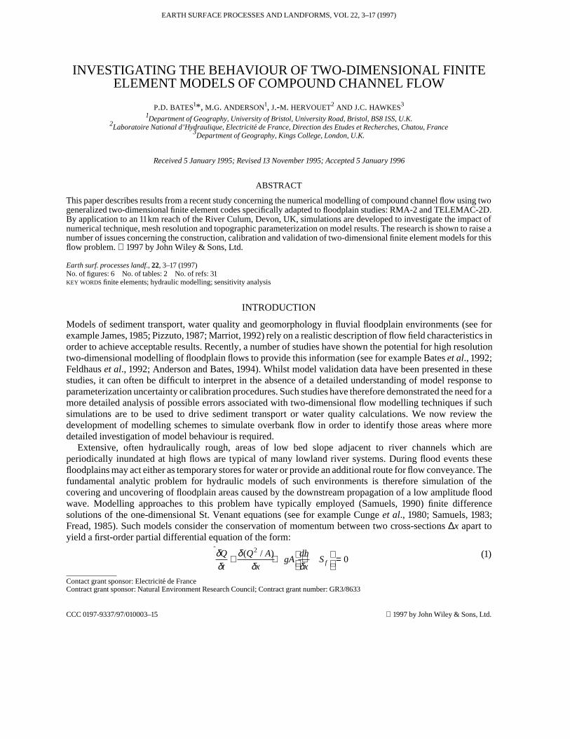
Two-dimensional finite element models as originally developed for application to free surface flowproblems are of limited use for floodplain studies due to their inability to realistically incorporate dry areaswithin the computational domain. In such models representation of the flow field boundary can only beachieved by including or eliminating partially wet elements from the solution domain as a whole (see Figure 1).
Figure 1. (a) Free surface position on a partially wet element. (b) Typical finite element interpolation of a free surface. (c) Interpolationachieved using the enhanced wetting and drying algorithm in TELEMAC-2D
5MODELS OF CHANNEL FLOW
Thus, the floodplain inundation extent is represented as an irregular front based on the element geometryrather than as a smooth feature. Undesirable, and potentially mathematically unstable, oscillations in the frontalposition or spurious flow velocities may also occur with such schemes in response to relatively small depthchanges. Research in this area (Lynch and Gray, 1980; King and Roig, 1988) has led to the development of twogeneralized two-dimensional finite element codes that have the potential to simulate the covering anduncovering of areas of low lateral bed slope in a realistic fashion: the RMA-2 code (King and Norton, 1978),originally developed for the US Army Corps of Engineers, and the TELEMAC-2D code, developed by theLaboratoire National d’Hydraulique, Chatou, France. The generalized RMA-2 code has been further developed(Gee et al., 1990; Bates et al., 1992) specifically to simulate river channel/floodplain flows and initial studiesmade applying the RMA-2 code to the River Fulda in Germany (Baird et al., 1992) and the River Culm, Devon,UK (Bates and Anderson, 1993; Anderson and Bates, 1994). These have demonstrated a number of topographicconstraints on the application of the RMA-2 code to floodplain studies. More recently, TELEMAC-2D has alsobeen enhanced (Hervouet and Janin, 1994; Bates et al., 1994) to provide a topographically robust high space/time resolution flood inundation modelling capability. RMA-2 and TELEMAC-2D therefore currentlyrepresent the only two-dimensional finite element models that have been specifically adapted for reach scalefloodplain flow simulations. Two-dimensional finite element modelling of floodplain flows has been shown tobe viable, giving model predictions broadly in line with field data and a logical response to simple sensitivityanalysis tests. The initial studies have, however, demonstrated the need for a more detailed analysis of modelnumerical solution and parameterization in a number of specific areas which we address in this paper:
1. investigation of the impact of alternative numerical solution techniques;2. examination of the impact of mesh resolution on model simulation results;3. initial quantification of the impact of topographic parameterization accuracy.
These issues currently represent those most poorly understood in relation to this flow modelling problem yetcan potentially have a significant impact on model results. We argue here that a fuller understanding of thebehaviour of the RMA-2 and TELEMAC-2D models for reach scale floodplain flows is an essentialprerequisite to the interpretation of theoretical or field based model validation studies. If the interaction betweenthe model numerical solution chosen and the derived parameter base is not made explicit, comparison ofsimulation results with validation data may be less convincing as scientific evidence than would otherwise bethe case. In this situation the extension of such simulations to drive distributed geomorphology and waterquality models may not be possible despite the obvious research benefits that would stem from such adevelopment. We now provide a description of the RMA-2 and TELEMAC-2D models prior to detailingresearch conducted to explore the three issues raised above.
DESCRIPTION OF THE SIMULATION MODELS
RMA-2 and TELEMAC-2D both solve second-order partial differential equations for depth averaged fluid flowderived from the full three-dimensional Navier–Stokes equations. This gives an equation set consisting of anequation for mass continuity (3) and two force–momentum equations ((4) and (5)). These are given in non-conservative form as:
(3)
(4)
(5)
δδ
δδ
δδ
δδ
δδ
δδ
δδ
u
tu h h u
u
tu u g
h
x hh u S g
Z
x
v
tu v g
h
y hh v S g
Z
y
xf
yf
+ + =
+ + − = −
+ + − = −
.grad( ) div( )
.grad( ) div(v grad( ))
.grad( ) div(v grad( ))
0
1
1
6 P. D. BATES, M. G. ANDERSON, J.-M. HERVOUET AND J. C. HAWKES
where u,v = velocity components in the x and y cartesian directions; h = depth of flow; Zf = bed elevation; v =turbulent viscosity; Sx,Sy = source terms; g = gravitational acceleration; t = time.
The models therefore solve for the three unknowns h, u and v. Both models employ a mean flow concept totreat turbulent flows, averaging instantaneous velocities over time to give mean motion only. In this formulationan additional term, the Reynolds stress, is added to the governing equations to represent the increased internalshear stress on mean flow produced by velocity fluctuations. Evaluation of the Reynolds stress term poses anumber of difficulties for field applications. To estimate this additional unknown and make the governingequations mathematically tractable, some model of the turbulence is therefore introduced. In both modelsemployed in this study the Boussinesq approximation is adopted. Here the Reynolds stress is assumed to be theproduct of the depth–mean velocity gradient and an exchange coefficient, ε, dimensionally similar to thecoefficient of viscosity, µ, and termed the eddy viscosity. This eddy viscosity term can then be used toparameterize the model or can be estimated through a further equation set, such as the k–ε model (Guiyi, 1992).For both models used in this study these additional terms were derived from a constant eddy viscosity model.
Specific attributes of the RMA-2 code
RMA-2 solves the shallow water equations for a continuum of triangular and quadrilateral elements using afully implicit implementation of the Galerkin weighted residual technique. This discretization is linear forwater depth and quadratic for flow velocity, giving six or eight nodes per triangular or quadrilateral elementrespectively. RMA-2 therefore allows meshes which contain a mixture of triangular and quadrilateral elementgeometries. Due to the extreme non-linearity of the governing equations the numerical integration for theGalerkin procedure is performed iteratively using a Newton–Raphson type solver (Norton et al., 1973). RMA-2fully assembles the matrices of the linear system at each iteration. As these matrices are both large and sparsethis can add significantly to the time required to perform a particular calculation, although implementation of asuitable element reordering scheme, such as the King (King, 1970) or Sloan (Sloan and Randolph, 1982)algorithms, can improve this position by reducing the matrix frontwidth.
In the original RMA-2 model, partially wet elements occurring during floodplain wetting and drying areeliminated from the solution domain if the water depth at any node within an element becomes less than zero.This so-called ‘step’ formulation unrealistically represents the flow boundary as an irregular wetting and dryingfront. To overcome this, the model has been upgraded to include a specific wetting and drying algorithm (Kingand Roig, 1988). This method modifies the governing equations for partially wet elements to simulate a smoothtransition between wet and dry states by defining a domain coefficient, θ, representing the proportion of anelement available for fluid flow. To approximate the flow boundary, partially wet elements are retained withinthe solution and the domain coefficient used to scale the simulated elemental water volume to the true volumeresiding on the element at each time step.
Specific attributes of the TELEMAC-2D code
To solve Equations (3), (4) and (5) TELEMAC-2D employs a fractional step method (Marchuk, 1975) whereadvection terms are solved initially, separate from propagation, diffusion and source terms, which are solvedtogether in a second step. This is achieved for a space discretization consisting of either linear triangular or bi-linear quadrilateral elements with three of four nodes per element respectively. Several schemes may be usedfor the advection step, with the Method of Characteristics chosen here for the momentum equation. To ensuremass conservation, two alternative schemes are available for the advection of h in the continuity equation: theStreamline Upwind Petrov Galerkin (SUPG) method (Brookes and Hughes, 1982) and a hybrid numericalmethod specifically developed for TELEMAC-2D. According to the SUPG technique, standard Galerkinweighting functions are modified by adding a streamline upwind perturbation. The hybrid numerical schemeconsists of a combination of the Method of Characteristics and centred differences, which sacrifices theunconditional stability of the Method of Characteristics for an improvement in mass conservation properties.The second step (propagation) of TELEMAC-2D makes use of an implicit time discretization and solves theresulting linear system with a conjugate gradient-type method. In addition, and unlike RMA-2, theTELEMAC-2D code makes significant savings in both computational time and storage requirements through
7MODELS OF CHANNEL FLOW
the use of an element-by-element solution technique. Here the matrices in the linear system are stored in theirelementary form without recourse to full assembly.
TELEMAC-2D incorporates an additional modification to simulate areas of low lateral bed slope such asfloodplains or tidal flats. If this option is not implemented, partially wet elements are retained within thesolution domain and the model interpolates a spurious non-zero lateral free water slope across the element (seeFigure 1b). For such an element the driving terms in the momentum equation are:
du dzdt dx
= − g (6)
where z = free surface elevation.
Other terms, for example friction, diffusion etc., still act on such an element but have been discarded forclarity. On dry elements a fictitious free surface slope is computed which can cause the numerical scheme tooverpredict flow velocities. The object of the modification for floodplain areas in TELEMAC-2D is to provide abetter approximation of the water surface slope. First, a check is made for each element to test for the existenceof a wet/dry boundary. If the bottom elevation for a particular node, Zf2 with depth h2, is greater than the watersurface elevation at one of the other nodes in that element with depth h1, then a new water surface elevation (z2)is defined as:
z2 = Zf1 + h2 (7)
This can then be used to develop more realistic flow velocities in floodplain areas (see Figure 1c). Moreover, asonly the momentum equation is modified, mass conservation properties are not affected.
A comparison of the numerical solution techniques employed by these models shows the TELEMAC-2Dscheme to be theoretically more efficient than RMA-2 due to its use of an element-by-element solver. Suchschemes have been shown to result in significant savings in both computational time and core storage (Binleyand Beven, 1992; Hervouet, 1993). The TELEMAC-2D model therefore has the potential to solve flowproblems requiring large numbers of finite elements and at a high time resolution. In addition, advanced
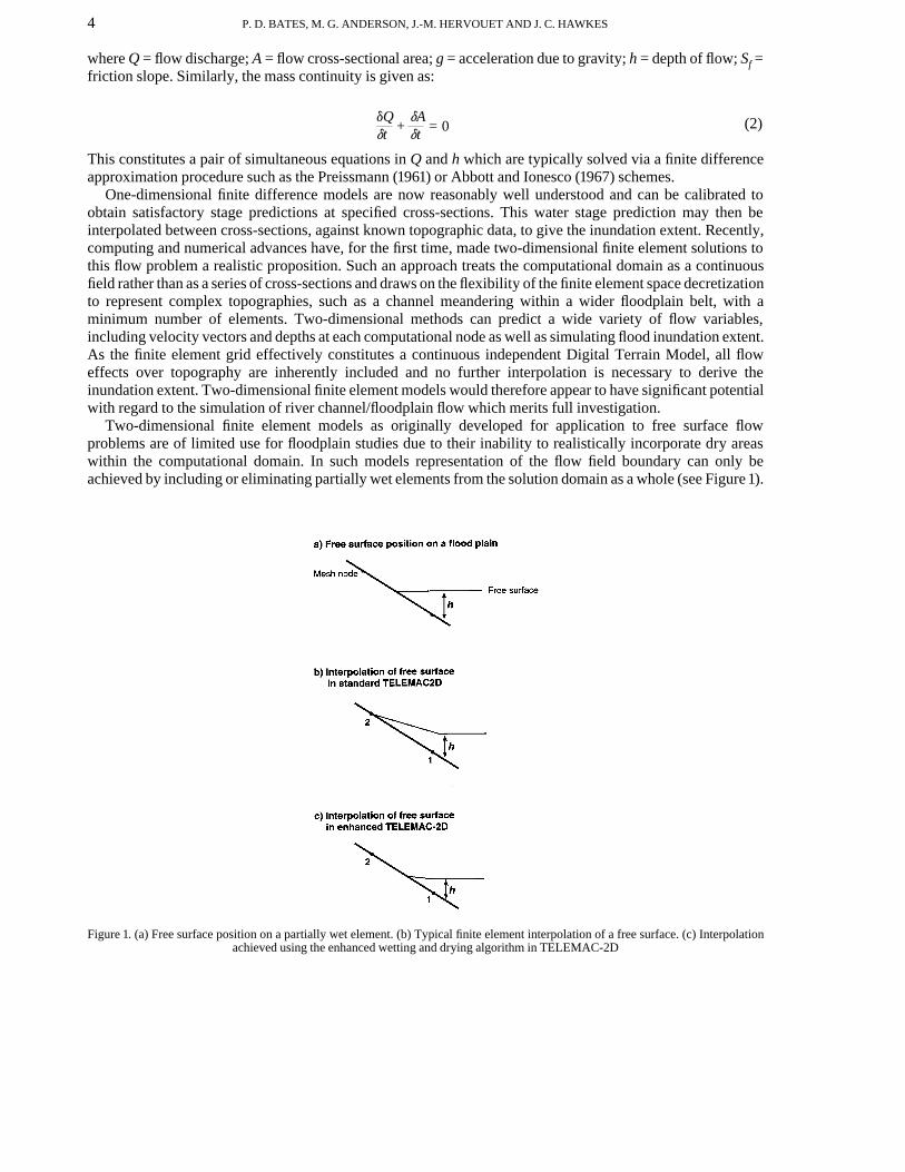
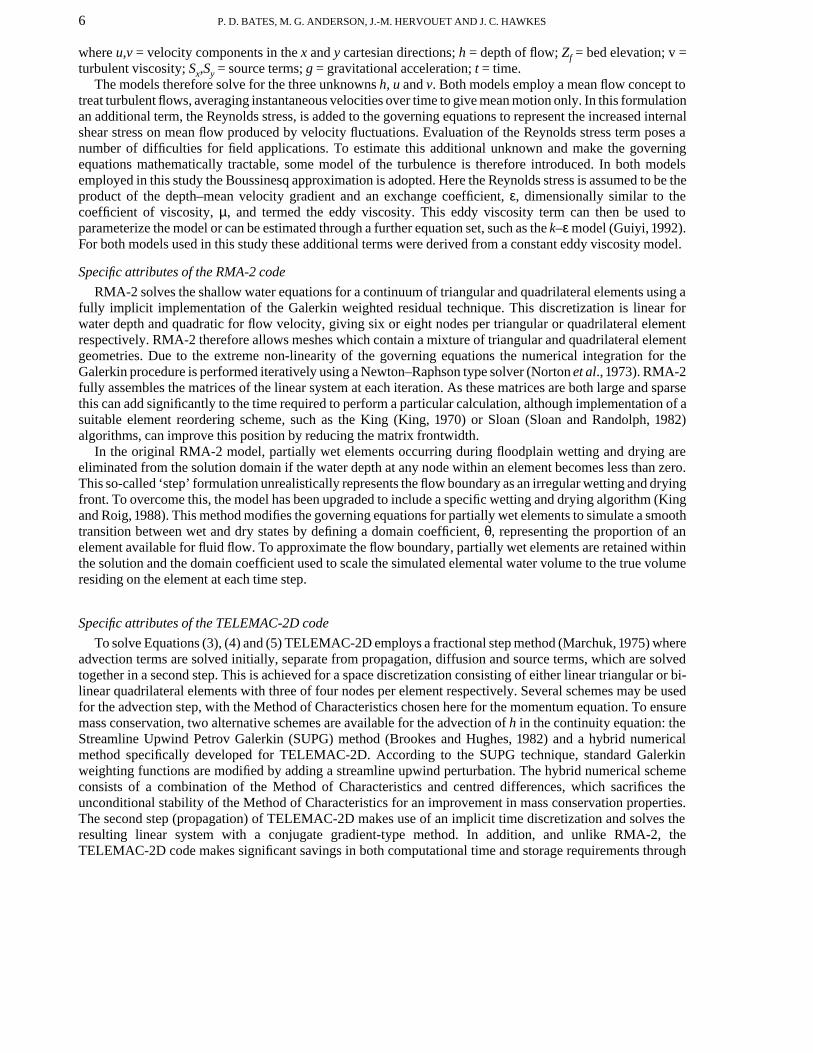
Figure 2. Low resolution finite element mesh of the River Culm, Devon, UK, for an 11km reach between the flow gauging stations atWoodmill (upstream) and Rewe (downstream)
8 P. D. BATES, M. G. ANDERSON, J.-M. HERVOUET AND J. C. HAWKES
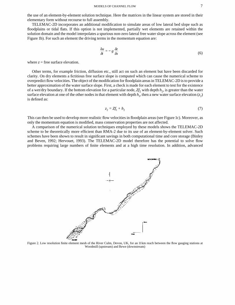
Figure 3. High resolution finite element mesh of the River Culm, Devon, UK, between Woodmill and Rewe
numerical techniques, such as the SUPG method, may confer a number of advantages in terms of accuracy andcomputational cost over standard Galerkin weighted residual solvers.
RESEARCH DESIGN AND NUMERICAL RESULTS
Examination of the three areas of interest outlined in the introduction to this paper was achieved in two parts.Firstly, a combined research design was devised to simultaneously analyse the impact of numerical solutiontechnique and mesh resolution using the RMA-2 and TELEMAC-2D models. Secondly, an initial attempt wasmade to quantify the impact of topographic parameterization with a distributed space/time sensitivity analysisusing the RMA-2 model only.
An 11km reach of the River Culm, Devon, UK, between established stage recorder gauging stations atWoodmill and Rewe (see Figure 2) was selected as the test site for these simulations. For this reach twotriangular finite element discretizations at low (see Figure 2) and high (see Figure 3) mesh resolutions wereconstructed. These were used for simulations with both numerical models in order to control for meshresolution effects. The low resolution mesh discretization was constructed to minimize computational effort,which in the case of RMA-2 also involved amalgamation of a number of triangular element pairs intoquadrilaterals to give a mix of triangular and quadrilateral elements. This was not expected to have a discernibleimpact on model results aside from an improvement in computational efficiency as the number and position ofcomputational nodes remained constant. Due to the constraint on the number of elements, however, bothRMA-2 and TELEMAC-2D low resolution meshes exhibit a high degree of distortion and no smooth transitionbetween elements of varying size, particularly in near-channel areas. A further high resolution discretizationwas therefore constructed by decreasing the length-to-breadth ratio of channel and near-channel elements fromapproximately 20:1 to 5:1. In order to obtain a comparison between mesh properties, the Courant number, anumerical scheme stability criterion, was calculated for each mesh/model combination using the equation:
9MODELS OF CHANNEL FLOW
DtDx
Cr = u
(8)
where Cr = Courant number; x = mesh size.
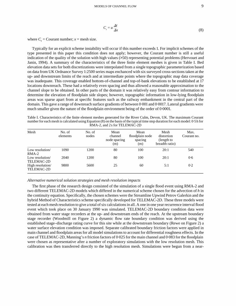
Typically for an explicit scheme instability will occur if this number exceeds 1. For implicit schemes of thetype presented in this paper this condition does not apply; however, the Courant number is still a usefulindication of the quality of the solution with high values (>50) representing potential problems (Hervouet andJanin, 1994). A summary of the characteristics of the three finite element meshes is given in Table I. Bedelevation data sets for both discretizations were interpolated from a single topographic parameterization basedon data from UK Ordnance Survey 1:2500 series maps enchanced with six surveyed cross-sections taken at theup- and downstream limits of the reach and at intermediate points where the topographic map data coveragewas inadequate. This coverage enabled bottom-of-channel and top-of-bank elevations to be established at 17locations downreach. These had a relatively even spacing and thus allowed a reasonable approximation to thechannel slope to be obtained. In other parts of the domain it was relatively easy from contour information todetermine the elevation of floodplain side slopes; however, topographic information in low-lying floodplainareas was sparse apart from at specific features such as the railway embankment in the central part of thedomain. This gave a range of downreach surface gradients of between 0·001 and 0·0017. Lateral gradients weremuch smaller given the nature of the floodplain environment being of the order of 0·0001.
Table I. Characteristics of the finite element meshes generated for the River Culm, Devon, UK. The maximum Courantnumber for each mesh is calculated using Equation (8) on the basis of the typical time step duration for each model: 0·5h for
RMA-2, and 2s for TELEMAC-2D
Mesh No. ofelements
No. ofnodes
Meanchannel
node spacing(m)
Meanfloodplain node
spacing(m)
Meshdistortion(length to
breadth ratio)
Max.Courant no.
Low resolution/RMA-2
1090 1200 80 100 20:1 540
Low resolution/TELEMAC-2D
2040 1200 80 100 20:1 0·6
High resolution/TELEMAC-2D
9800 5600 25 60 5:1 0·2
Alternative numerical solution strategies and mesh resolution impacts
The first phase of the research design consisted of the simulation of a single flood event using RMA-2 andtwo different TELEMAC-2D models which differed in the numerical scheme chosen for the advection of h inthe continuity equation. Specifically, the chosen schemes were the Streamline Upwind Petrov Galerkin and thehybrid Method of Characteristics scheme specifically developed for TELEMAC-2D. These three models weretested at each mesh resolution to give a total of six calculations in all. A one in one year recurrence interval floodevent which took place on 30 January 1990 was simulated. TELEMAC-2D boundary condition data wereobtained from water stage recorders at the up- and downstream ends of the reach. At the upstream boundarystage recorder (Woodmill on Figure 2) a dynamic flow rate boundary condition was derived using theestablished stage–discharge rating curve for this site while at the downstream boundary (Rewe on Figure 2) awater surface elevation condition was imposed. Separate calibrated boundary friction factors were applied inmain channel and floodplain areas for all model simulations to account for differential roughness effects. In thecase of TELEMAC-2D, Manning’s n friction factors of 0·025 for the main channel and 0·083 for the floodplainwere chosen as representative after a number of exploratory simulations with the low resolution mesh. Thiscalibration was then transferred directly to the high resolution mesh. Simulations were begun from a near-
10 P. D. BATES, M. G. ANDERSON, J.-M. HERVOUET AND J. C. HAWKES
steady-state condition and consisted of 27,000 time steps of 2 s duration. This appeared to be the optimum forminimizing computational time.
RMA-2 calculations performed using the flood event described above also employed an imposed flow rate asthe upstream boundary condition and began from a near-steady-state condition. Simulations did, however,differ in terms of downstream boundary condition, friction factor and time step. Here a stage–dischargerelationship was used as the downstream boundary condition. This was used to define a nominal flow rate whichwas then treated in an identical manner to an imposed flow boundary condition. Calibrated boundary frictionparameterizations were also based on the Manning’s n coefficient, again differentiating between main channel,n = 0·03, and floodplain, n = 0·1. Both RMA-2 and TELEMAC-2D parameterizations are within physicallyrealistic limits for this type of environment (Acrement and Schneider, 1984). The friction calibrations arebroadly consistent, with the differences in roughness parameterization, reflecting the fact that in this study wecompare best fit calibrations which give minimum phase error between predicted and observed hydrographpeaks for each model. If a single calibration were used, one model would have an implicit advantage and thecomparative nature of the present study would be invalidated. Finally, as both RMA-2 and TELEMAC-2D usea fully implicit solver, no stability problems relating to Courant number were experienced. For RMA-2 a large,1800 s (or 0·5 h), time step could therefore be employed. This had the advantage of minimizing the adverseimpact on computational time resulting from full assembly of the matrices of the linear system. This does,however, result in a high value for the Courant number (see Table I) which can potentially indicate problemswith the solution of the controlling equations (Hervouet and Janin, 1994).
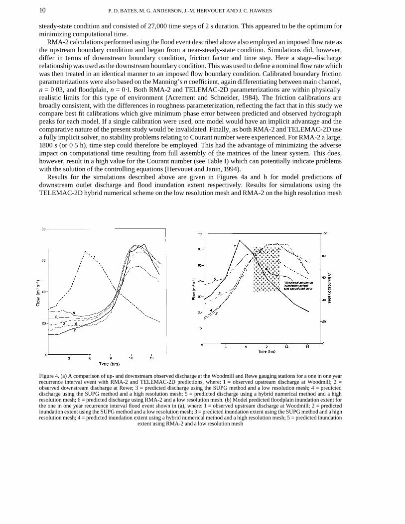
Results for the simulations described above are given in Figures 4a and b for model predictions ofdownstream outlet discharge and flood inundation extent respectively. Results for simulations using theTELEMAC-2D hybrid numerical scheme on the low resolution mesh and RMA-2 on the high resolution mesh
Figure 4. (a) A comparison of up- and downstream observed discharge at the Woodmill and Rewe gauging stations for a one in one yearrecurrence interval event with RMA-2 and TELEMAC-2D predictions, where: 1 = observed upstream discharge at Woodmill; 2 =observed downstream discharge at Rewe; 3 = predicted discharge using the SUPG method and a low resolution mesh; 4 = predicteddischarge using the SUPG method and a high resolution mesh; 5 = predicted discharge using a hybrid numerical method and a highresolution mesh; 6 = predicted discharge using RMA-2 and a low resolution mesh. (b) Model predicted floodplain inundation extent forthe one in one year recurrence interval flood event shown in (a), where: 1 = observed upstream discharge at Woodmill; 2 = predictedinundation extent using the SUPG method and a low resolution mesh; 3 = predicted inundation extent using the SUPG method and a highresolution mesh; 4 = predicted inundation extent using a hybrid numerical method and a high resolution mesh; 5 = predicted inundation
extent using RMA-2 and a low resolution mesh
11MODELS OF CHANNEL FLOW
were unsuccessful and are not therefore shown. TELEMAC-2D simulations employing the hybrid numericalscheme on the low resolution mesh displayed a number of problems including poor mass conservationproperties, irregular velocity vectors and significant negative depths. The method was therefore rejected as anappropriate numerical technique for use with such highly distorted meshings. In the case of RMA-2 simulationson the high resolution mesh, the computer storage requirments generated by the necessity to fully assemblematrices at each time step significantly exceeded available memory on a high powered workstation, even whenan accepted frontwidth reduction algorithm (King, 1970) was used. Supercomputer simulations may provide asolution here although for practical purposes this calculation is not currently feasible. Solution of highresolution fluid flow problems would thus appear to be best performed with an element-by-element code wherematrices are stored in their elementary form. Computation times on an HP9000/735 workstation for theremaining successful simulations are given in Table II.
Table II. Computation times and efficiencies for simulations of a one in one year recurrence interval flood event conductedon an HP9000/735 workstation using a variety of numerical techniques and mesh resolutions
Mesh/solver No. of nodes Computation time(min)
Efficiency (time per 1000nodes per time step)
Low resolution/RMA-2 1200 265 7·361 minLowe resolution/SUPG 1200 320 0·593sHigh resolution/SUPG 5600 2188 0·868sHigh resolution/hybrid 5600 2930 1·162s
Little difference in simulated discharge or inundation extent is shown between TELEMAC-2D calculationsmade with the SUPG and hybrid numerical solution schemes. The SUPG scheme appears to attain a moreconvincing initial steady state, but once the rising limb of the hydrograph is reached the hybrid numericaltechnique produces near-identical discharge predictions. In terms of computation time, the SUPG method ismore efficient (see Table II), giving an approximate 28 per cent reduction in computational requirements forthis flow problem over the alternative hybrid scheme. Over the entire simulation the SUPG scheme also gave anapproximate 20 per cent reduction in the relative error on mass calculated by the model. The Galerkin weightedresidual technique employed by RMA-2 correctly predicts the timing but not the nagnitude of the observeddischarge peak. Fully implicit Galerkin techniques of the type employed by RMA-2 have been shown byFourier analysis to have an undesirable damping effect on the solution by reducing the amplitude of simulatedwaves. It may be that this is a cause of the underprediction of the flood peak by RMA-2 whereby the dampingeffect would not allow the model to capture the full dynamic range of the hydrograph. Further testing would beneeded to determine this conclusively. Despite this, all simulations show a realistic initial decline in dischargemagnitude. RMA-2 and TELEMAC-2D similarly estimate maximum inundation extent but differ in both thetiming and range predicted. This may partially be a consequence of not controlling for roughnessparameterization in the two schemes. In addition, both models commence the simulation with a partially wetfloodplain; this implies either that the flow field along the reach prior to the flood event was not a steady state orthat the channel topographic resolution was not sufficient to precisely identify bankfull discharge in particularlocations. Previous studies with TELEMAC-2D (Hervouet and Janin, 1994) have shown that simulations can bedeveloped with a completely dry mesh and continued until the flood has receded. With RMA-2, however,model instability was noted for floodplain states that were predominantely dry, particularly under conditions offlood wave recession.
Moving from a low to a high resolution finite element mesh, TELEMAC-2D shows relatively littleimprovement in the accuracy of discharge predictions. The high resolution mesh gives a better fit to the peakdischarge; however, timing of the peak and the initial part of the simulation are replicated more closely by thelow resolution mesh. This probably reflects a need to refine the calibration for the high resolution mesh insteadof merely transferring the previously derived low resolution calibration. This implies that calibrations are, tosome extent, discretization specific and non-stationary. Both finite element meshes do, however, produce goodresults well within the error limits of the data set. In terms of TELEMAC-2D inundation extent, the highresolution mesh predicts a greater range than the low resolution mesh, albeit with similar timing, and is also able
12 P. D. BATES, M. G. ANDERSON, J.-M. HERVOUET AND J. C. HAWKES
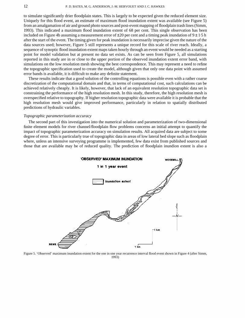
to simulate significantly drier floodplain states. This is largely to be expected given the reduced element size.Uniquely for this flood event, an estimate of maximum flood inundation extent was available (see Figure 5)from an amalgamation of air and ground photo sources and post-event mapping of floodplain trash lines (Simm,1993). This indicated a maximum flood inundation extent of 68 per cent. This single observation has beenincluded on Figure 4b assuming a measurement error of ±20 per cent and a timing peak inundation of 9 ± 1·5 hafter the start of the event. The timing given for peak inundation is necessarily imprecise given the nature of thedata sources used; however, Figure 5 still represents a unique record for this scale of river reach. Ideally, asequence of synoptic flood inundation extent maps taken hourly through an event would be needed as a startingpoint for model validation but at present no data set exists. As can be seen from Figure 5, all simulationsreported in this study are in or close to the upper portion of the observed inundation extent error band, withsimulations on the low resolution mesh showing the best correspondence. This may represent a need to refinethe topographic specification used to create the model, although given that only one data point with assumederror bands is available, it is difficult to make any definite statement.
These results indicate that a good solution of the controlling equations is possible even with a rather coarsediscretization of the computational domain and that, in terms of computational cost, such calculations can beachieved relatively cheaply. It is likely, however, that lack of an equivalent resolution topographic data set isconstraining the performance of the high resolution mesh. In this study, therefore, the high resolution mesh isoverspecified relative to topography. If higher resolution topographic data were available it is probable that thehigh resolution mesh would give improved performance, particularly in relation to spatially distributedpredictions of hydraulic variables.
Topographic parameterization accuracy
The second part of this investigation into the numerical solution and parameterization of two-dimensionalfinite element models for river channel/floodplain flow problems concerns an initial attempt to quantify theimpact of topographic parameterization accuracy on simulation results. All acquired data are subject to somedegree of error. This is particularly true of topographic data in areas of low lateral bed slope such as floodplainwhere, unless an intensive surveying programme is implemented, few data exist from published sources andthose that are available may be of reduced quality. The prediction of floodplain inundion extent is also a
Figure 5. ‘Observed’ maximum inundation extent for the one in one year recurrence interval flood event shown in Figure 4 (after Simm,1993)
13MODELS OF CHANNEL FLOW
quantity with a high sensitivity to topographic parameterization, as a small error in the specified bed elevationmay have a large impact on the predicted lateral extent of the flow field.
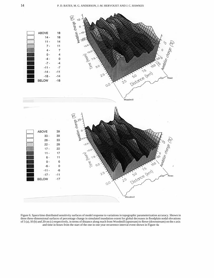
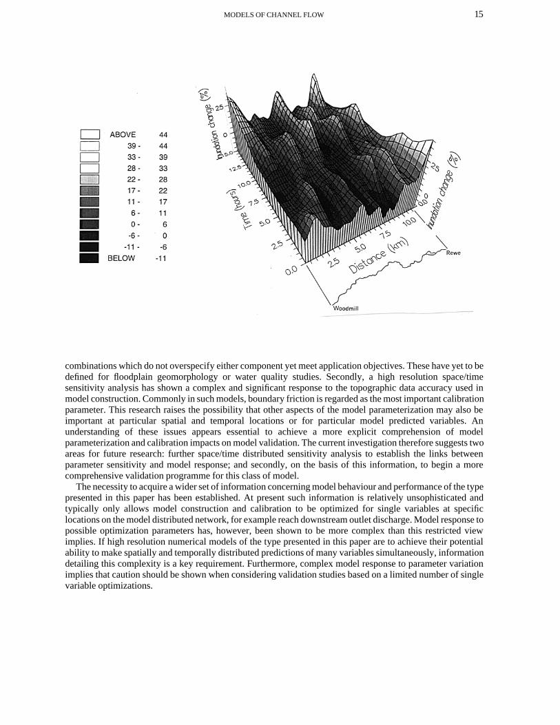
These effects have been examined using a distributed sensitivity analysis to determine spatial and temporalvariations in model response to varying topographic parameterization accuracy. Initially, this investigation hasbeen solely conducted using the RMA-2 finite element code in conjunction with the low resolution mesh shownin Figure 2 and the one in one year recurrence interval flood event described above. Four model simulations ofthis flood event were conducted: a control calculation and three further calculations where all floodplain nodeswere lowered by 5, 15 and 20cm from their original elevation respectively. These values were chosen as theywere felt to be representative of the accuracy of topographic parameterization found for floodplainenvironments. Although a uniform change in floodplain elevation would not be a typical error surface, such ananalysis should be capable of giving a preliminary indication of model sensitivity in this respect and providenecessary information for a more sophisticated research design. For each simulation a time sequence offloodplain inundation extent maps was constructed at intervals of 3 h. Then for a series of 20 cross-sectionsalong the reach, approximately 0·5km apart, the percentage floodplain inundation was determined. Theincrease in inundation extent at these points caused by a lowering of the floodplain surface could then becalculated and variation of this quantity in both space and time obtained. These data are summarized for the −5,−15 and −20cm treatments in Figures 6a, b and c.
Figure 6 indicates that certain areas of the mesh are more sensitive to inaccuracies in topographicparameterization than others and, moreover, that this sensitivity is consistent within treatments over the courseof a dynamic flood simulation. This is evidenced by the strong ridges present in the data, indeed in the initialstages of the simulation some decreases in inundation extent, representing negative sensitivites, are apparent.This is probably a consequence of the dynamic nature of the simulation and illustrates the insights into modelperformance to be gained from this type of analysis. The passage of a floodwave through the reach can beclearly seen as a trough in the sensitivity surface running from approximately 2·5h into the simulation at thehead of the reach to approximately 10h at the downreach end. This is an artefact of the analysis method wherebyduring periods of high floodplain occupancy only small increases in percentage inundation are possible.Correlations between aspects of model geometry such as floodplain width and lateral slope have also beeninvestigated as possible means of explaining some of the pattern in the sensitivity surface, but no significantrelationship has been found (Bates and Anderson, 1996). Figure 6 also shows significant variation in space/timeresponse between treatments. The results imply that the accuracy of topographic data used to parameterize themodel may be more important in some specific locations than others, a conclusion that, potentially, hassignificant implications for data collection programmes for two-dimensional finite element schemes. It is cleartherefore that even such a restricted investigation as outlined here may be able to aid in the design of field datacapture programmes and show the potential of the methodology for understanding complex modelling systems.
DISCUSSION
This paper has successfully applied two two-dimensional finite element codes to a relatively long (11km) riverreach with the specific aim of investigating the numerical solution, discretization and parameterization of thisclass of scheme for river flood simulation problems. In terms of the relative merits of the two schemes, theRMA-2 code incurs the lower computational cost due to the use of a relatively long time step. This may,however, give a high Courant number. Despite the fact that model stability is not affected by such constraintsfor an implicit scheme, the physical basis of the Courant number means that for a good quality solution it isoften desirable to keep within a reasonable limit. For this reason the TELEMAC-2D code may provide a moreaccurate solution of the controlling equations and this would appear to be borne out by the data presented inFigure 4a.
Two separate issues arising from this study should be highlighted. Firstly, this research has indicated apotentially significant interaction between the resolution of the topographic data used to establish the model andthe resolution of the finite element mesh employed. Both mesh construction and topographic data capture havesignificant resource requirements which the modelling process should seek to minimize. A primaryrequirement for future research is therefore the development of an ability to identify mesh/topography
14 P. D. BATES, M. G. ANDERSON, J.-M. HERVOUET AND J. C. HAWKES
Figure 6. Space/time distributed sensitivity surfaces of model response to variations in topographic parameterization accuracy. Shown inthree three-dimensional surfaces of percentage change in simulated inundation extent for global decreases in floodplain nodal elevationsof 5 (a), 10 (b) and 20cm (c) respectively, in terms of distance along reach from Woodmill (upstream) to Rewe (downstream) on the x axis
and time in hours from the start of the one in one year recurrence interval event shown in Figure 4a
15MODELS OF CHANNEL FLOW
combinations which do not overspecify either component yet meet application objectives. These have yet to bedefined for floodplain geomorphology or water quality studies. Secondly, a high resolution space/timesensitivity analysis has shown a complex and significant response to the topographic data accuracy used inmodel construction. Commonly in such models, boundary friction is regarded as the most important calibrationparameter. This research raises the possibility that other aspects of the model parameterization may also beimportant at particular spatial and temporal locations or for particular model predicted variables. Anunderstanding of these issues appears essential to achieve a more explicit comprehension of modelparameterization and calibration impacts on model validation. The current investigation therefore suggests twoareas for future research: further space/time distributed sensitivity analysis to establish the links betweenparameter sensitivity and model response; and secondly, on the basis of this information, to begin a morecomprehensive validation programme for this class of model.
The necessity to acquire a wider set of information concerning model behaviour and performance of the typepresented in this paper has been established. At present such information is relatively unsophisticated andtypically only allows model construction and calibration to be optimized for single variables at specificlocations on the model distributed network, for example reach downstream outlet discharge. Model response topossible optimization parameters has, however, been shown to be more complex than this restricted viewimplies. If high resolution numerical models of the type presented in this paper are to achieve their potentialability to make spatially and temporally distributed predictions of many variables simultaneously, informationdetailing this complexity is a key requirement. Furthermore, complex model response to parameter variationimplies that caution should be shown when considering validation studies based on a limited number of singlevariable optimizations.
16 P. D. BATES, M. G. ANDERSON, J.-M. HERVOUET AND J. C. HAWKES
ACKNOWLEDGEMENTS
This research was made possible by the support of Electricite de France, Direction des Etudes et Recherches,Chatou, France, and the Natural Environment Research Council in the UK (Grant Number GR3/8633).
REFERENCES
Abbott, M. B. and Ionesco, F. 1967. ‘On the numercial computation of nearly horizontal flows’, Journal of Hydraulics Research, 5, 97–117.
Acrement, G. J. and Schneider, V. R. 1984. Guide for selecting Manning’s roughness coefficients for natural channels and floodplains,U.S. Department of Transportation, Federal Highways Administration, Report No. FHWA-TS-84-204, 62 pp.
Anderson, M.G. and Bates, P.D. 1994. ‘Initial testing of a two-dimensional finite element model for floodplain inundation’, Proceedingsof the Royal Society of London Series A, 444, 149–159.
Baird, L., Gee, D. M. and Anderson, M. G. 1992. ‘Ungauged catchment modelling II. Utilization of hydraulic models for validation’,Catena, 19, 33–42.
Bates, P.D. and Anderson, M.G. 1993. ‘A two-dimensional finite element model for river flow inundation’, Proceedings of the RoyalSociety of London Series A, 440, 481–491.
Bates, P. D. and Anderson, M. G. 1995. ‘A preliminary investigation into the impact of initial conditions on flood inundation predictionsusing a time/space distributed sensitivity analysis’, Catena, 26, 115–134.
Bates, P.D., Anderson, M.G., Baird, L., Walling, D.E. and Simm, D. 1992. ‘Modelling floodplain flows using a two-dimensional finiteelement model’, Earth Surface Processes and Landforms, 17, 575–588.
Bates, P. D., Anderson, M. G. and Hervouet, J.-M. 1994. ‘Computation of a flood event using a two-dimensional finite element model andits comparison to field data’, in Molinaro, P. and Natale, L (Eds), Modelling Flood Propagation Over Initially Dry Areas, AmericanSociety of Civil Engineers, New York, 243–256.
Binley, A. and Beven, K. 1992. ‘Three-dimensional modelling of hillslope hydrology’, Hydrological Processes, 6, 347–359.Brookes, A. N. and Hughes, T. J. R. 1982. ‘Streamline Upwind/Petrov Galerkin formulations for convection dominated flows with
particular emphasis on the incompressible Navier-Stokes equations’, Computer Methods in Applied Mechanics and Engineering, 32,199–259.
Cunge, J. A., Holly, F. M. and Verwey, A. 1980. Practical Aspects of Computational River Hydraulics, Pitman, London, 420 pp.Feldhaus, R., Hottges, J., Brockhau, T. and Rouve, G. 1992. ‘Finite element simulation of flow and pollution transport applied to a part of
the River Rhine’, in Falconer, R. A., Shiono, K. and Matthews, R. G. S. (Eds), Hydraulic and Environmental Modelling; Estuarine andRiver Waters, Ashgate Publishing, Aldershot, 323–334.
Fread, D. L. 1985. ‘Channel routing’, in Anderson, M. G. and Burt, T. P. (Eds), Hydrological Forecasting, John Wiley and Sons,Chichester, 437–503.
Gee, D. M., Anderson, M. G. and Baird, L. 1990. ‘Large scale floodplain modelling’, Earth Surface Processes and Landforms, 15, 512–523.
Guiyi, L. 1992. ‘Turbulence modelling’, Proceedings of the Institution of Civil Engineers, Water, Maritime and Energy, 96, 187–192.Hervouet, J.-M. 1993. ‘Validating the numerical simulation of dam-breaks and floods’, Advances in Hydro-Science and Engineering
Volume 1 Part A, Washington, USA, 754–761.Hervouet, J.-M. and Janin, J.-M. 1994. ‘Finite element algorithms for modelling flood propagation’, in Molinaro, P. and Natale, L. (Eds),
Modelling Flood Propagation Over Initially Dry Areas, American Society of Civil Engineers, New York, 102–113.James, C. S. 1985. ‘Sediment transfer to overbank sections’, Journal of Hydraulic Research, 23, 435–452.King, I. P. 1970. ‘An automatic reordering scheme for simultaneous equations derived from network systems’, International Journal of
Numerical Methods in Engineering, 2, 523–533.King, I. P. and Norton, W. R. 1978. ‘Recent applications of RMA’s finite element models for two-dimensional hydrodynamics and water
quality’, Proceedings of the Second International Conference on Finite Elements in Water Resources, Pentech Press, London, 81–99.King, I. P. and Roig, L. C. 1988. ‘Two-dimensional finite element models for floodplains and tidal flats’, in Niki, K. and Kawahara, M.
(Eds), Proceedings of an International Conference on Computational Methods in Flow Analysis, Okayama, Japan, 711–718.Lynch, D. R. and Gray, W. G. 1980. ‘Finite element simulations of flow deforming regions’, Journal of Computational Physics, 36, 135–
153.Marchuk, G. I. 1975. Methods of Numerical Mathematics, Springer-Verlag, New York, 316 pp.Marriot, S. 1992. ‘Textural analysis and modelling of a flood deposit: River Severn, UK’, Earth Surface Processes and Landforms, 17,
687–697.Norton, W. R., King, I. P. and Orlob, G. T. 1973. A finite element model for Lower Granite Reservoir: a report prepared for the U.S. Army
Corps of Engineers, Walla Walla District, Washington, Water Resources Engineers, Walnut Creek, California, 105 pp.Pizzuto, J. E. 1987. ‘Sediment diffusion during overbank flows’, Sedimentology, 34, 301–317.Preissmann, A. 1961. ‘Propagation des intumescences dans les canaux et rivieres’, 1er Congres de l’Association Francaise de Calcul,
Grenoble, 433–442.Samuels, P. G. 1983. ‘Computational modelling of flood flows in embanked rivers’, Proceedings of an International Conference on the
Hydraulic Aspects of Floods and Flood Control, BHRA, 229–240.Samuels, P. G. 1990. ‘Cross section location in one-dimensional models’, in White, W. R. (Ed.), International Conference on River Flood
Hydraulics, John Wiley and Sons, Chichester, 339–350.

17MODELS OF CHANNEL FLOW
Simm, D. 1993. The deposition and storage of suspended sediment in contemporary floodplain systems: a case study of the River Culm,Devon, Unpublished Ph.D. Thesis, University of Exeter.
Sloan, S.W. and Randolph, M.F. 1982. ‘Automatic reordering for finite element analysis with frontal solution’, International Journal ofNumerical Methods of Engineering, 19, 1153–1181.


![INVESTIGATING THE NON-LINEAR BEHAVIOR OF RC FRAMED ...€¦ · K braced frame. [5] Investigated the behavior of RC beam-column connection using finite element analysis. Separate finite](https://img.pdfslide.us/doc/110x75/605faa960f9bec1b2d32278a/investigating-the-non-linear-behavior-of-rc-framed-k-braced-frame-5-investigated.jpg)