Embed Size (px)
Citation preview

JULY 2013
MINISTRY OF ENVIRONMENT AND FORESTS
INVENTORY AND MAPPING
OF PROBABLY CONTAMI-
NATED SITES IN INDIA DRAFT REPORT OF TASK 5: PRIORITIZATION OF SITES


JULY 2013
MINISTRY OF ENVIRONMENT AND FORESTS
INVENTORY AND MAPPING
OF PROBABLY CONTAMI-
NATED SITES IN INDIA DRAFT REPORT OF TASK 5: PRIORITIZATION OF SITES
ADDRESS COWI A/S
Parallelvej 2
2800 Kongens Lyngby
Denmark
TEL +45 56 40 00 00
FAX +45 56 40 99 99
WWW cowi.com
PROJECT NO. A019251
DOCUMENT NO. 011
VERSION 001
DATE OF ISSUE 10 July 2013
PREPARED DH, TJR
CHECKED SV
APPROVED SV


http://projects.cowiportal.com/ps/A019251/Documents/3 Project documents/Reports/Task 5 Proritization system/Draft Task 5 report Prioritization system (2).docx
CONTENTS
1 Introduction 7
2 Review of existing approaches 9
3 Selection of appropriate prioritization /ranking
system 12
4 Level of information 14
5 Approach proposed 16
5.1 Introduction 16
5.2 Step 1 Prioritization 17
5.3 Step 2 Prioritization 19
5.4 Calibration and refinement 22
5.5 Testing and review against initial site data 22
5.6 Application to full database 22
6 Plan for completing Task 5 23
APPENDICES
Appendix A Comparison of Prioritization Systems
Appendix B Parameters in Prioritization Systems
Appendix C Methodologies examined


INVENTORY AND MAPPING OF PROBABLY CONTAMI-NATED SITES IN INDIA
http://projects.cowiportal.com/ps/A019251/Documents/3 Project documents/Reports/Task 5 Proritization system/Draft Task 5 report Prioritization system (2).docx
7
1 Introduction
The current Report provides a status of the Task 5 Prioritization of Sites for the
project Inventory and Mapping of Probably Contaminated Sites In India, which
was awarded by the Ministry of Environment and Forest to a Consortium
consisting of COWI as lead partner in association with KADAM, Witteveen+Bos
and Tauw as sub-consultants. The Project is funded by the World Bank (WB). Our
work is coordinated with the other two assignments of the National Program for
Rehabilitation of Polluted Sites (NPRPS); Assignment 2: the Development of
Methodologies for NPRPS and Assignment 3: Development of National Program
for Rehabilitation of Polluted Sites
Task 5 is one out of the five tasks to be completed in this project, see the
conceptual model shown on next page.
Objectives The objective of the total assignment is to prepare an inventory of contaminated
sites across India, which will provide information to Central and State governments
when preparing and implementing the National Program for Rehabilitation of
Polluted Sites (NPRPS). The Inventory must be a dynamic tool where data are
adjusted and supplemented on a regular basis.
8 INVENTORY AND MAPPING OF PROBABLY CONTAMI-NATED SITES IN INDIA
http://projects.cowiportal.com/ps/A019251/Documents/3 Project documents/Reports/Task 5 Proritization system/Draft Task 5 report Prioritization system (2).docx
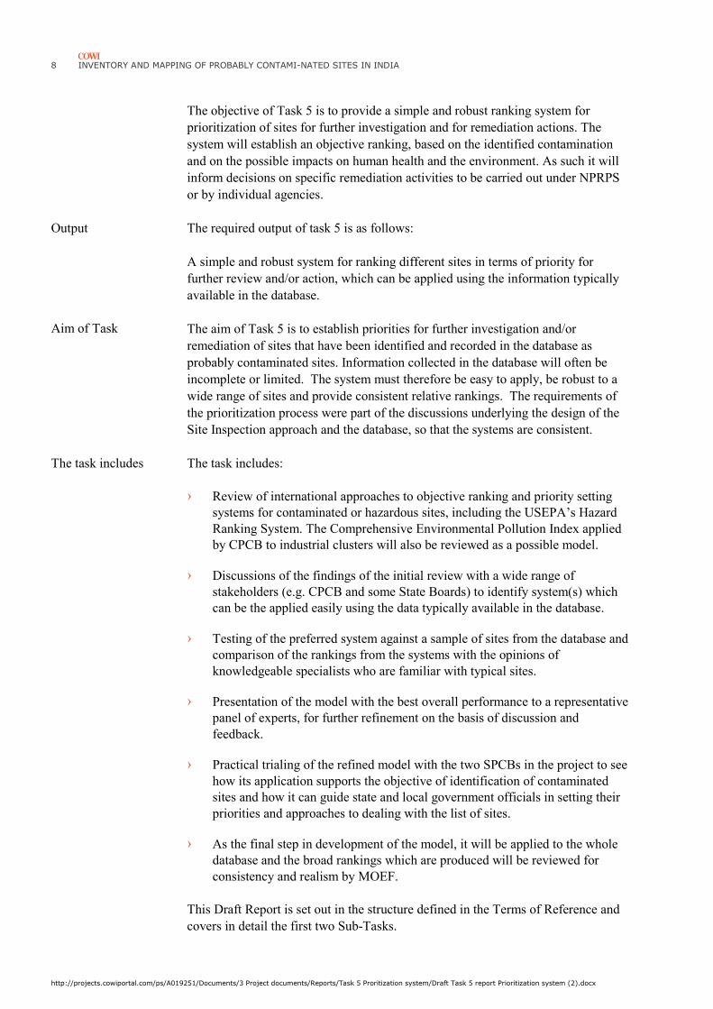
The objective of Task 5 is to provide a simple and robust ranking system for
prioritization of sites for further investigation and for remediation actions. The
system will establish an objective ranking, based on the identified contamination
and on the possible impacts on human health and the environment. As such it will
inform decisions on specific remediation activities to be carried out under NPRPS
or by individual agencies.
Output The required output of task 5 is as follows:
A simple and robust system for ranking different sites in terms of priority for
further review and/or action, which can be applied using the information typically
available in the database.
The aim of Task 5 is to establish priorities for further investigation and/or
remediation of sites that have been identified and recorded in the database as
probably contaminated sites. Information collected in the database will often be
incomplete or limited. The system must therefore be easy to apply, be robust to a
wide range of sites and provide consistent relative rankings. The requirements of
the prioritization process were part of the discussions underlying the design of the
Site Inspection approach and the database, so that the systems are consistent.
The task includes The task includes:
› Review of international approaches to objective ranking and priority setting
systems for contaminated or hazardous sites, including the USEPA’s Hazard
Ranking System. The Comprehensive Environmental Pollution Index applied
by CPCB to industrial clusters will also be reviewed as a possible model.
› Discussions of the findings of the initial review with a wide range of
stakeholders (e.g. CPCB and some State Boards) to identify system(s) which
can be the applied easily using the data typically available in the database.
› Testing of the preferred system against a sample of sites from the database and
comparison of the rankings from the systems with the opinions of
knowledgeable specialists who are familiar with typical sites.
› Presentation of the model with the best overall performance to a representative
panel of experts, for further refinement on the basis of discussion and
feedback.
› Practical trialing of the refined model with the two SPCBs in the project to see
how its application supports the objective of identification of contaminated
sites and how it can guide state and local government officials in setting their
priorities and approaches to dealing with the list of sites.
› As the final step in development of the model, it will be applied to the whole
database and the broad rankings which are produced will be reviewed for
consistency and realism by MOEF.
This Draft Report is set out in the structure defined in the Terms of Reference and
covers in detail the first two Sub-Tasks.
Aim of Task

INVENTORY AND MAPPING OF PROBABLY CONTAMI-NATED SITES IN INDIA
http://projects.cowiportal.com/ps/A019251/Documents/3 Project documents/Reports/Task 5 Proritization system/Draft Task 5 report Prioritization system (2).docx
9
2 Review of existing approaches
There are a range of different prioritization systems that have been developed over
the years, mainly drawing on initial work in the 1990s in the USA to assess
identified sites in terms of their importance for inclusion into the National Priorities
List under Superfund.
A review for the European Environment Agency identified 27 different
methodologies worldwide which were, or had been, used in preliminary risk
assessment (see appendix C). The coverage and level of detail of these varies
considerably. After examination of the available information on the system, six of
these are judged to be relevant to the present task. To these six, are added the
Blacksmith Index (from the Blacksmith Institute, currently applied to sites
worldwide) and the Comprehensive Environmental Pollution Index (CEPI)
developed for the CPCB and used in assessment of industrial clusters in India.
The eight selected systems have been examined in some detail for essential
characteristics and for similarities. This range of approaches is believed to cover
the plausible range of practical systems that are available as models for the present
task.
The essential characteristics of the eight systems are summarized immediately
below and the systems are compared in Annex A.
Objective is to assess the relative potential of sites to pose a threat to human health.
Use to register “uncontrolled waste sites” onto National Priorities List. Does not
determine prioritize for funding.
Uses “complex and structured analytical approach to scoring risks”. Main
indicators are in three categories: likelihood of release of hazardous material from
site; toxicity and quantity of the waste; people or sensitive areas as “targets”. Each
pathway scored on sources; likelihood of release; waste characteristics; targets.
Algorithm: Each pathway scored based on estimation of indicators, factors and
parameters. Multiplicative relations, then normalized to 100 point scale. HRS
overall score is based on root-mean square of pathway scores. Source hazard is
based on toxicity/carcinogenicity. Pathways evaluated are Groundwater; surface
water; soil exposure; air. For each of these specific receptors are used.
USEPA Hazard
Ranking System
(1990)

10 INVENTORY AND MAPPING OF PROBABLY CONTAMI-NATED SITES IN INDIA
http://projects.cowiportal.com/ps/A019251/Documents/3 Project documents/Reports/Task 5 Proritization system/Draft Task 5 report Prioritization system (2).docx
Objective is to establish rational and consistent basis for comparative assessment of
contaminated sites, as input to national remediation program.
Additive numerical method based on sum of indicator scores for Contaminants
Characteristics plus Exposure Pathways plus Receptors.
Ranking puts sites in one of four classes: high; medium; medium-low; and low
risk.
Objective is to provide rapid hazard assessment, sufficient to prioritise sites for
further investigation.
Based on a multiplicative Source –Pathway - Receptor approach, scaled to 0 to1.
Highest score of three pathways used. Factors based on mix of quantitative and
qualitative values.
Objective is to define the “remediation urgency” of sites affected by serious soil
contamination.
Compares site contamination levels against generic intervention values. If above,
then calculation to show whether expected exposure is above human toxicological
intervention values. Separate procedure for ecological risk.
Concentrations in soil can be used to calculate expected concentrations in contact
media and thus exposures, unless actual data exist for contact media, which then
take precedence. Different pathways considered for human health risk, including
direct contact, food, fishing, drinking water.
Output is determination of timescale over which that responsible authority must
start remediation.
Objective is to determine whether further investigations are needed, based on
ranking to three classes of risk.
Focus is on direct contact and water pathways, with calculations using basic data
on contamination levels at source. Scores given on 0 to 3 scale for each element
and combined in “simple algorithm” for each pathway/land use. Highest score
applies.
Objective is to provide local authorities with prioritization system for sites about
which little is known. The prioritization system uses the Source-Pathway-Receptor
concept to assess risks. It is split into two steps. The Step I assessment involves
hazard ranking sites based on their historical industrial uses and the receptor’s
sensitivity. The Step II procedure involves refining the assessment from Step I by
carrying out an exposure assessment. Default data on industry types and potential
receptors used in Step 1. For Step 2 source contaminant data used. Land,
Groundwater and Surface water pathways/receptors assessed separately. Additive
algorithm (matrix) for Contaminant and Pathway/Receptor.
Final risk score is max of the three pathways.
Canada National
Classification
System (NCS) for
contaminated sites
(1992)
New Zealand Risk
Screening System
(2003)
The Netherlands
Remediation
Urgency Method
(1995)
France - Simplified
Risk Assessment
(2001)
GeoEnviron System
for the Prioritization
of Point Sources
(2003)

INVENTORY AND MAPPING OF PROBABLY CONTAMI-NATED SITES IN INDIA
http://projects.cowiportal.com/ps/A019251/Documents/3 Project documents/Reports/Task 5 Proritization system/Draft Task 5 report Prioritization system (2).docx
11
Objective is comparative ranking of contaminated sites worldwide in terms of
health risk.
Source contaminant levels and population at risk are main factors, with pathway
adjustment. The ranking is additive algorithm, using logarithms of key values.
Basic data from standardized site screening visit methodology.
Objective is to help categorizing areas in terms of priority of planning for
intervention in relation to environmental parameters. The system has been applied
to 88 industrial clusters across India, using data from local agencies. Use additive
approach across pollution pathway and receptor. Penalty values calculated for each
factor in each pathway, and then cluster ranked by total score, with 70/100
regarded as “critically polluted”.
The eight systems listed here have been reviewed in detail and a comparative table
prepared (below) setting out key features of each, as the basis for developing a
system appropriate to the situation in India.
Blacksmith Index
(2006)
India
Comprehensive
Environmental
Pollution Index
(CEPI) (2009)

12 INVENTORY AND MAPPING OF PROBABLY CONTAMI-NATED SITES IN INDIA
http://projects.cowiportal.com/ps/A019251/Documents/3 Project documents/Reports/Task 5 Proritization system/Draft Task 5 report Prioritization system (2).docx
3 Selection of appropriate prioritization
/ranking system
Based on the analysis carried out of the candidate systems, there are common
features in several that can be taken and adapted for use but none is directly
applicable to the current situation in India. The US system is very detailed and
requires considerable information and then draws on specific US data. The
Canadian and New Zealand approaches were developed for specific programs and
are not readily adaptable. The Netherlands approach requires detailed information,
which is typically already available for sites in that country. The French system is
based on specific values for contaminants which are not readily available and
comparable. The UK/Denmark model from Geokon is broadly applicable. A GIS
system is incorporated and the system also includes a 2 step prioritization system
which is suitable for India condition. The Blacksmith Index is applicable but may
not be detailed enough for the requirements of the Ministry. The CEP'I Index
developed for the CPCB is also broadly appropriate but has been developed for
ongoing industrial activity where monitoring data is available and so cannot be
applied directly.
There is enough broad consistency between these different systems to be able to
identify some common features which are taken as the basis for the prioritization
system for this project.
Broad findings On the basis of detailed review of the models discussed above, the following
findings can be set out, with their implications for this project.
› There is no analytical model which is common to most of the models but the
Source-Pathway-Receptor approach is basis for all the systems.
› The key parameters can be values (concentrations, populations) or can be
marks (typically on a scale of 1 to 10).
› Some systems are tailored/biased to particular problems (such as petroleum
contamination) while others are more general but less detailed
› Most systems address impacts on humans, groundwater and surface water. In
some cases they are combined into one overall score: in others they are

INVENTORY AND MAPPING OF PROBABLY CONTAMI-NATED SITES IN INDIA
http://projects.cowiportal.com/ps/A019251/Documents/3 Project documents/Reports/Task 5 Proritization system/Draft Task 5 report Prioritization system (2).docx
13
reported separately. Ground- or surface water can, in some cases, be both
pathway and receptor.
› Data requirements vary. In some systems, default data on sources is provided
or can be used, avoiding or reducing the need for site investigations (but
requiring information on past use and industrial types).
› There are a number of definitions of the receptor, ranging from any human
exposure to estimating the populations affected, usually by distance from the
source.
› The sensitivity of a system to small differences can be increased, at the cost of
additional complexity, which means more variables and data required. (See
table comparing parameters in appendix A)
› The basic algorithm is based either on adding scores for element (additive) or
on multiplying them together (multiplicative). There is no fundamental
reason to prefer one approach over the other. Some systems are a mixture of
both approaches.
› Systems produce either a score or assign a site to a class (typically high,
medium, low, or unclassified). Some systems use the score to produce a
classification.
The approach adopted for this project is based on the Source – Pathway – Receptor
conceptual model, which underlies all the systems reviewed. The logic for this
approach is simple and universally accepted.
It draws on data from Task 1 and 4, which includes site specific information and
sampling data to the extent possible.
The model is to be robust to uncertainty in the data (a small change in the
information available should not make a significant difference in the priority
ranking or classification). Given the constrained coverage and quality of the
information from Task 1 and 4, the precision expected of the output is to be no
more than two significant figures – in other words, it will rank sites on a scale of 1
to 100.
The model uses professional experience and judgment for the details of
calculations and the calibration of the parameters. The approach used is clear and
the relevance and importance of each factor can easily be seen in the outputs.
The model contains the three major components of source, pathways and receptor.
The table in Annex B sets out the main parameters in the five of the current
systems examined that are most accessible and are the best models for the system
to be used in this project.
Basics of proposed
approach
Detailed options for
prioritization process

14 INVENTORY AND MAPPING OF PROBABLY CONTAMI-NATED SITES IN INDIA
http://projects.cowiportal.com/ps/A019251/Documents/3 Project documents/Reports/Task 5 Proritization system/Draft Task 5 report Prioritization system (2).docx
4 Level of information
Based on the information from the visited institutions and organizations, we have
in Task 1 identified a total of approx. 600 sites all around the country. Table 4.1
gives an overall status of the information level of obtained data in Task 1 and
expected outcome of information obtained in Task 4 (Site Inspection).The level of
information of each site varies widely.
In Task 1 (desktop study) we have obtained reasonable good information about the
general site information and information about source and waste characteristics,
but very little information about pathways. At some sites, there is detailed
information including primary data and knowledge about source, pathways and
receptors. For a few sites, the knowledge is very limited e.g. with virtually only
information about the name and location of the site.
In Task 4 we will obtain supplementary information about the sites based on the
Site Inspections at 100 sites with special information about pathways, receptors and
primary data. In general we expect that the sites can be classified in two categories:
› Site with high level of information: This includes the 100 sites where Site
Inspection will be conducted and probably some additional sites with data
from previous site investigations (e.g. sites investigated by SPCBs, MoEF and
CPCB). Due to combined desk top study and Site Inspection most data in table
4.1 will be available.
› Site with medium to low level of information. This include the remaining
number of sites identified in Task 1 (in total 400-500 sites)

INVENTORY AND MAPPING OF PROBABLY CONTAMI-NATED SITES IN INDIA
http://projects.cowiportal.com/ps/A019251/Documents/3 Project documents/Reports/Task 5 Proritization system/Draft Task 5 report Prioritization system (2).docx
15
Table 4-1 Typical level of information based on data collection in task 1
Topic Explanation Level of information
Task 1
(~ 600 sites)
Task 4
(~100 sites)
Ge
ne
ral
site
in
form
ati
on
Approximate area of site 3-4 4-5
Type of Site 1 = "Point" site (Single industrial site/dump site), 2 =
"Area" site Industrial area or estate (cluster) 3 = Other
4 5
Type of contamination Effluent, Air, Municipal Solid Waste, Bio-medical Waste,
Hazardous Waste, Ship Break Waste, Other
4 5
Type of Industry Types of industrial uses the site has been subjected to 3-4 5
Industrial processes, Type
of hazardous waste
Activity which caused the contamination: According to
schedule 1 – HW Rules 2008
3-4 4-5
Period of operation Beginning year and end year e.g. 1988 - 1995 2 3-4
Operational status Active/ongoing, Closed, Abandoned, Other 3-4 5
Previous or ongoing
remediation activities
Remediation activities 2-3 5
So
urc
e
Primary Contaminant(s) The most important Chemical names is specified 3-4 5
Source characteristic Area and volume of contaminated soil, Physically state of
waste as deposited, Visual contamination
2-3 4-5
Origin of the deposit 2-3 4-5
Existing primary data
Analysis results from e.g. soil, groundwater, surface water,
air
2-3 5
Pa
thw
ay
s
Geology at the site Broad description of the typical stratigraphical sequences 2-3 5
Hydrogeology at the site Overall description of aquifers 2-3 5
Any drainage system
on/outside the site
General description of (drain, trenches, streams) or
streams at the site
1-2 5
Any flooding If any flooding frequency and type should be described 1-2 5
Surface water body Type of Surface water Body , distance from site, 3-4 5
Sensitive use of surface water
Prevailing wind direction 1 4
Re
cep
tors
Use of groundwater aquifer Current and future planned use of any aquifer 3-4 5
Drinking water intakes Distances to nearest well (private and public) 1-2 5
Surface water use Sensitive use of surface water 1-2 5
Ecological areas (m) E.g. Reserves, wetland 1 5
Land use (on site) Agriculture land, Waste land, Water bodies, Forests,
Habitation settlement, Commercial, Industrial, Mixed ,
Other
Previous = 2-3
Current = 3-4
Future = 1-2
Previous = 2-3
Current = 5
Future = 2-3
Land use (vicinity of site) 3-4 5
Activity in the vicinity of the
site?
Distance to nearest habitation or other sensitive activities
(e.g. Kindergarden)
3-4 5
Socio economic conditions 2-3 5
Potential/observed
pathways for spreading
Groundwater pathway, Surface Water pathway, Soil
exposure pathway, Air pathway
2-3 5
Potential/observed
exposure
Direct human contact, Ingestion, Groundwater/surface
water use, Inhalation, Sensitive environments
2-3 5
Observed impacts E.g. observed impacts on humans, animals, flora, fauna 1-2 5
Total population at risk Population at risk 3-4 5
Note: * Score: 1 = Obtained for nearly no sites (< 10%), 2 = Obtained for around 10-40 % of sites, 3 = Obtained for
half of sites (40-60 %), 4 = Obtained for most sites (60-90%), 5 = Obtained for nearly all sites (>90 %)

16 INVENTORY AND MAPPING OF PROBABLY CONTAMI-NATED SITES IN INDIA
http://projects.cowiportal.com/ps/A019251/Documents/3 Project documents/Reports/Task 5 Proritization system/Draft Task 5 report Prioritization system (2).docx
5 Approach proposed
5.1 Introduction
Based on the detailed review of the different systems in use worldwide, an
approach has been adopted for the project which is simple and robust. In the Indian
context, where there are a very wide range of potentially contaminated sites and
where the population numbers to be considered can be high, reliability over a range
of situations is important.
The approach uses an algorithm (a formula) which links the Source, Pathway and
Receptor elements, using values for each parameter based on actual measurements
from the site, as recorded in the database. The algorithm produces a priority value
for each site, which is compared with the equivalent values for other sites to
provide the overall ranking of all the sites in the database.
The practical construction of the algorithm comprises two parts: the STRUCTURE,
which links the different parameters, and the individual PARAMETERS, which are
based on the values in the database.
Flexibility must be allowed for refinement of the model after the initial period of
use so that additional factors can be included if these are demonstrated to be
important. For this reason, the model has to be conceptually clear and logical.
Overall structure The proposed overall structure for the algorithm, based on review of the other
systems and initial testing of the robustness of the approach, is as follows. This can
be simplified for a first step analysis with limited data.
SCORE = (source term)(modified by pathway factor) PLUS (terms for receptors:
population; groundwater, sensitivity)
This is a simple and flexible structure which is consistent with the models
reviewed. The effectiveness of the model comes from the selection of the specific
terms and of the values to be used for the parameters.

INVENTORY AND MAPPING OF PROBABLY CONTAMI-NATED SITES IN INDIA
http://projects.cowiportal.com/ps/A019251/Documents/3 Project documents/Reports/Task 5 Proritization system/Draft Task 5 report Prioritization system (2).docx
17
Two step approach As described in section 4 the level of information for the individual sites in general
can be divided in 2 groups: 1) Sites with information based on Desk top studies and
b) Sites with information from both Desk top study and Site inspection). After
discussions with MoEF at the meeting in Delhi 16 May 2013, it was agreed that
the prioritization system should include a two-step approach:
› Step 1: Initial Prioritization. This ranking of sites are based on basic
information which typically will be obtained in a desktop study and will cover
all the sites identified in Task 1. The Step I assessment involves hazard
ranking sites based on their historical industrial uses and the receptor’s
sensitivity. The step I assessment can be carried out very rapidly, providing
that source and receptor information is available
› Step 2: Detailed Prioritization: This ranking of sites is based on more detailed
information about the sites including primary data and a site reconnaissance
(e.g. a Site Inspection). This ranking will cover the inspected sites in Task 4,
and also other sites where previous investigations has been performed. The
Step II assessment involves refining the priority listing obtained from step I,
by carrying out a Site Inspection with assessment of pathway and exposure to
determine whether or not a potential pollutant linkage exists. The step II also
include obtaining primary data of contaminants.
5.2 Step 1 Prioritization
Objective The objective of Step 1 prioritization is to establish a prioritization system for
probably contaminated sites about which little is known. The system should be able
to include all sites which have been identified as a “Probably contaminated site”.
The system should prioritize sites based on their potential risk to humans.
Step 1 prioritization applies when the information available consists only of basic
information (or even assumptions) about the site and its surroundings and it does
not require a Site Inspection. It is applied at an early phase to a large number of
sites, in order to identify those which appear to present a serious risk and for which
further data should be obtained. In the current project, Step 1 can be applied for all
sites in the database.
Formula The formula is simplified to reflect the basics of the situation, which are the scale
of the source and the size and sensitivity of the receptor. The Step 1 score could be
determined as:
Step I Priority Score = [Industry; source] + [Land use + Population +
Groundwater + Surface water; receptors]
The first step of the site prioritization is based solely on the types of industrial uses
the site has been subjected to and the sensitivity of the potential receptors. The
issue of pathways is considered in Step 2.
Parameters Proposed parameters for the Step 1 Prioritization is shown in table 5.1.

18 INVENTORY AND MAPPING OF PROBABLY CONTAMI-NATED SITES IN INDIA
http://projects.cowiportal.com/ps/A019251/Documents/3 Project documents/Reports/Task 5 Proritization system/Draft Task 5 report Prioritization system (2).docx
Table 5.1 Input parameter for Step 1 Prioritization
Para-
meter
S-P-R* Description Basis Range Data source Comment
I Source Industry type Scoring Low,
Med, High risk
1 - 3 Information is obtained in
Task 1 (desktop study) or in
Task 4 (Site Inspection).
List of “Industry types” are
presented in Task 1 report .
The Geoenviron include a
list of 50 Industry types
which can be used initially
L Recepto
r
Land Use Scoring Low,
Med, High Risk
1 - 3 Information is obtained in
Task 1 (desktop study) or in
Task 4 (Site Inspection).
List of land use categories
proposed in Task 1 report
will be used
P Population at risk Estimated within
1 km. Log(pop) or
Low, Med, High
1 - 3 Information can be
obtained in Task 1 (desktop
study) as a simple spatial
query performed in a digital
map (e.g. Google map) or in
a GIS system. Information
can also be obtained in
Task 4 (Site Inspection)
This will be a rough
estimate. Accuracy of
population estimates only
order of magnitude
G Groundwater
system at risk
Use/importance
of aquifer; Low,
Med, High
0 – 3 Information can be
obtained from “Central
Ground Water Board”,
http://cgwb.gov.in/District_
Profile/AP_districtProfiles.h
tml
Classification system must
be performed. Should be
discussed with Central
Ground Water Board.
S Surface water
system at risk
Use/importance
of water source;
Low, Med, High
0 - 3 To be specified but should
be obtained from Central
Government Board
*: Source – Pathway – Receptor
Source The source scale can be taken from a table prepared for common types of Industry
types (e.g. industrial dumps, petrochemical plants, tanneries, chemical
manufacturing etc.), where each Industry type is given a hazard score based on the
contaminants likely to be present on the site. E.g. Tannery operation will give a
high hazard score due to the use of several toxic compounds (e.g. Chromium VI
which is carcinogenic and highly mobile in groundwater and surface water). Also
chemical manufacturing of e.g. herbicides will have a high score due to the highly
toxic compounds. The scoring for each Industry type can be divided in hazard
scores in relation to land use, ground and surface water receptors. For example lead
contamination from “Metal smelting operation” can cause a high risk for humans
(direct contact) but only a low risk for groundwater due to the low mobility of lead
in the subsurface.
Information about Industry types will be available for most sites.
The population at risk and the presence of an important groundwater/surface water
resource can be determined from readily available maps (whether hard copy or
GIS).

INVENTORY AND MAPPING OF PROBABLY CONTAMI-NATED SITES IN INDIA
http://projects.cowiportal.com/ps/A019251/Documents/3 Project documents/Reports/Task 5 Proritization system/Draft Task 5 report Prioritization system (2).docx
19
Pathways Because of the lack of information for many sites the pathway term is not included
in the Step I prioritization.
Receptor The fundamental receptor is the population potentially exposed (P). The current
“Land use” at the site (L) is also included as a parameter although it is our
experience from Task 1 (data collection), that information about land use can be
difficult to obtain in a desktop study. The relevant population has to be identified in
order to characterize P. This will be estimated based on distance (e.g. population
within a certain radius – typically 1 km).
Groundwater (G) and Surface water (S) at risk are included in the receptor
parameters. These parameters are added to the human receptor score. Information
can be obtained from Central Government Board.
Where the data required is not available, implementation of the method can be
based on assumptions. In such cases, we propose to assume a worst case scenario
for each situation. Further information should then be collected in order to verify
assumptions made and further refine the priority listing.
5.3 Step 2 Prioritization
For the sites where a Preliminary Investigation has been carried out and where
more details are provided in the database, a step 2 Prioritization system can be
applied.
Objective The objective is to establish a more robust prioritization system. The system will
cover sites where primary data is available and where a Site Inspection has been
performed. The system should prioritize sites based on their potential risk to
humans and the environment.
The Step 2 assessment involves refining the priority listing obtained from step I, by
carrying out a Site Inspection to obtain primary data and to assess pathway and
exposure routes to determine whether or not a potential pollutant linkage exists.
Prosed scoring formula The proposed algorithm is as follows:
Priority score =
{[Concentration + Quantity + Toxicity + Mobility]*Pathway} +
{Land use + Population + Sensitivity + Groundwater + Surface water +
Ecosystem}
The proposed algorithm is basically additive, except for the pathway factor.
Alternative structures for the algorithm and possible ranges of values for each of
the parameters will be considered during the testing and the refinement of this
prioritization process.
The priority score, as outlined in the box above, can be written as:

20 INVENTORY AND MAPPING OF PROBABLY CONTAMI-NATED SITES IN INDIA
http://projects.cowiportal.com/ps/A019251/Documents/3 Project documents/Reports/Task 5 Proritization system/Draft Task 5 report Prioritization system (2).docx
Step 2 Priority Score = [C +Q +T +M](F) + [L + P +S +G +S + E]
Parameters The starting parameters and numerical ranges used in the first iteration of
calibration and testing of the model are shown in table 5.2.
Table 5.2: Initial Parameter values for testing system.
Para-
meter
S-P-R * Description Basis Range Data Source
C Source
Source concentration Marks as Low, Med, High or
Ratio to Screening Level
1 - 4 To be obtained from Site Inspection in
Task 4 and/or from previous
investigation performed at the site
Q Quantity of source Volume, or Low, Med, High 1 - 3 To be obtained from desktop study
and/or Site Inspection in Task 4
T Toxicity Factor A list of Chemicals 0 - 2 Can be obtained from CEPI or the
Geoenviron Data Base
M Mobility List – chemical
characteristics
0 - 2 Can be obtained from Geoenviron Data
Base
F
Pathway Pathway factor Conn x Att (see description
below)
1 – 0.01 To be calculated based on Conn and Att
Conn (Containment) Site Report 1 – 0.1 To be specified, Technical judgement
Att (Attenuation) Pathway, tables 1 – 0.1 Reflecting directness of path to receptor.
Can be obtained from US values
L Recep-
tors
Landuse at the site Scoring Low, Med, High
Risk
1 - 3 Information is obtained during Site
Inspection
P Population at risk Estimated within 1km.
Log(pop) or Low, Med, High
1 – 3 Can be obtained from Task 1 (desktop
study) or from Task 4 (Site Inspection)
S
Sensitivity of receptor Guidance to be developed 0 – 1 Based on observation from Site
Inspection e.g. part of the population is
particularly at risk or disadvantaged
G Groundwater system
at risk
Use/importance of aquifer;
Low, Med, High
0 – 3 Classification system must be performed.
Information can be obtained from
“Central Government Boards ” and/or
from Site Inspection
S Surface water at risk Use/importance of surface
water; Low, Med, High
0-3
E Sensitive ecosystems Designated reserves, etc 0 – 3
*: Source – Pathway – Receptor
Source term The source term is a measure of the scale and risk of the critical contaminant. This
is in common with most of the systems reviewed, the approach here uses one
“dominant” contaminant but it is possible to use a combination where there are
high values for several different contaminants.
The basic source term is the concentration (C) of the pollutant at the site in relation
to the relevant screening value. This number can be a simple ratio of actual to
action value or can be a score reflecting the extent of the over-standard. Where
there is a very wide range of high values across sites, the logarithm of the values
can be used. The current uses of the site are taken into account by selecting the
screening value appropriate for that land use. In cases where there is no
information on the concentration (or where the sampling data is very limited or
unreliable) it is possible to use estimates of the typical levels of contamination
using data from similar sites or informed judgments.

INVENTORY AND MAPPING OF PROBABLY CONTAMI-NATED SITES IN INDIA
http://projects.cowiportal.com/ps/A019251/Documents/3 Project documents/Reports/Task 5 Proritization system/Draft Task 5 report Prioritization system (2).docx
21
To characterize the source better, terms are added for the quantity (Q), the toxicity
(T) and the mobility of the contaminant (M). The quantity is scored in terms of an
estimate of size (small, medium, large). This factor can also be used to reflect a
source that is a cluster of industries, where the value of Q is increased to capture
the overall scale of the collective source. This is equivalent to the CEPI factor for
scale of industrial activity. Toxicity and mobility scores are based on specific
characteristics of the contaminant, as recorded in the scientific literature.
Pathway The pathway term is a measure of how direct is the path from the source to the
receptor. In this model, it is structured to be a modifier of the source term.
For sites where the critical receptor is actually on the site (for example people
living on polluted land) then the pathway is direct and the pathway factor (F) is
unity. A land use risk factor (L) is incorporated to reflect a generalized concept of
the pathway and receptor, in cases where there is little information on these.
Where the receptors are off-site then some reduction in the risk will occur, based
on two main factors. First, the existence or provision of containment (or restriction
of access) will reduce exposure to the source. Second, distance from the source
will normally reduce the exposure (simple geometry shows that the concentration
will drop with increasing radius from the site) unless there is a narrow and direct
pathway (such as prevailing winds, a defined groundwater plume or a waterway).
The factor F is therefore a function of (i) containment, and (ii) attenuation and is
assessed on a scale of 1 to zero. Containment can be estimated in terms of the
probable effectiveness of control measures. Attenuation depends on the pathway
and requires judgment to assess but there is some guidance from international
practice, which suggests the appropriate ranges.
Receptor The fundamental receptor is the population potentially exposed (P) and in the
present formulation, additional receptor parameters can be used for groundwater
(G), surface water (W) and for sensitive environments (E). These parameters are
added to the human receptor score. This means that a site which has many impacts
will get a high score, while a site that has serious ecological impacts but limited
human ones (for example) will be given a score to reflect this risk. Plausible
values for these parameters are being tested empirically.
The relevant population has to be identified in order to characterize P. This is
sometimes based on distance (e.g. population within a certain radius – typically 1
km) or may be estimated in terms of pathway assumptions, such as number of well
water users or the population directly downwind.
The present model includes a sensitivity factor (S) which would signify that the
exposed population (or environment) were particularly at risk or disadvantaged.
This could refer, for example, to children being particularly exposed or that
particular population having particularly constrained options to avoid or deal with
the problem.

22 INVENTORY AND MAPPING OF PROBABLY CONTAMI-NATED SITES IN INDIA
http://projects.cowiportal.com/ps/A019251/Documents/3 Project documents/Reports/Task 5 Proritization system/Draft Task 5 report Prioritization system (2).docx
5.4 Calibration and refinement
The prioritization process is a pragmatic and judgmental one. The next step is
calibration of the proposed form and the main alternatives against a representative
sample of sites, to ensure that consistent results are obtained, and that they are
reviewed and modified in the light of informed expert opinion in India.
The proposed algorithm can be readily tested and revised in a spreadsheet format.
Once the final structure is agreed, it will be integrated into the final database. This
initial application in a spreadsheet will allow the algorithm and alternative
formulations to be readily and transparently applied to a sample of the sites in the
database, as the basis for review, discussion and refinement.
5.5 Testing and review against initial site data
This prototype system will be calibrated against the available site data in the
database. This will test the application of the prioritization and ranking system. A
critical element will be to carry out sensitivity testing to ensure that changes in the
input data do not create unreasonable changes in priorities.
5.6 Application to full database
The prioritization system will be constructed so that it can be readily applied to the
whole database and will allow for any future adjustments easily to be implemented.
A process for interpretation, evaluation and upgrading of the results will also be set
out.
INVENTORY AND MAPPING OF PROBABLY CONTAMI-NATED SITES IN INDIA
http://projects.cowiportal.com/ps/A019251/Documents/3 Project documents/Reports/Task 5 Proritization system/Draft Task 5 report Prioritization system (2).docx
23
6 Plan for completing Task 5
We propose the following activities to complete the prioritization system in Task 5:
› Our proposed approach will be discussed with MoEF and World Bank
› Our approach will be modified based on comments from MoEF and World
Bank.
› The refined model will be tested against representative sites from the database
in a spreadsheet format
› The model will be presented to a representative panel of stakeholders (e.g.
CPCB and some State Boards) and experts and will be refined on the basis of
discussion and feedback.
Once the final structure is agreed, it will be integrated into the GeoEnviron
database.

24 INVENTORY AND MAPPING OF PROBABLY CONTAMI-NATED SITES IN INDIA
http://projects.cowiportal.com/ps/A019251/Documents/3 Project documents/Reports/Task 5 Proritization system/Draft Task 5 report Prioritization system (2).docx
Appendix A Comparison of Prioritization
Systems

INVENTORY AND MAPPING OF PROBABLY CONTAMI-NATED SITES IN INDIA
http://projects.cowiportal.com/ps/A019251/Documents/3 Project documents/Reports/Task 5 Proritization system/Draft Task 5 report Prioritization system (2).docx
25
Annex A: Comparison of Prioritisation systems
Topic US EPA: Hazard Ranking System
(HRS)
Canada: National Classification System for
Contaminated Sites
New Zealand: Risk Screening System Netherlands: Remediation Urgency Method (in
Dutch “SUS”)
Broad structure HRS addresses risks in terms of potential or
actual release of hazardous substances; waste
characteristics; and targets affected. Produces
score which is used to put sites on National
Priorities List
Assesses hazard of site on basis of limited site
specific data. Calculates Site classification score
based on indicator scores for sources, pathways
and receptors. Sites ranked into four classes,
based on score.
Aims to provide a nationally consistent ranking of
sites that are, or suspected, contaminated using
readily available information. The purpose of
ranking a site is to prioritize for further
investigation. A simplified version of earlier
system.
Introduced in by government in 1994 to prioritise
the remediation of contaminated sites . Based
on human and ecological risk assessment and
risks of contaminant migration. Replaced by new
model “SANSCRIT” available only in Dutch
Where applied Used in US since 1990. Basis for listing of
Superfund sites. Still available for assessment of
new sites.
Developed in 2005 and updated 2008. One of
several tools used to ensure consistency in
implementation of national programme
Released 2001, updated 2007. To prioritize sites
for further investigation. Originally linked to
fund which is now closed.
Regularly used in Netherlands in context of
extensive available technical information and
pathway specific models.
Details of source Uses sample data showing values above human
health benchmark; or estimate using waste
quantity and toxicity; mobility; etc
characteristics. Also release/containment
characteristics.
Scores given for toxicity, area and state of
contaminants. If no data, then may be
“unclassified”.
Score 1 to 10 based on broad types of waste or
source.
Site contamination levels (normally as measured)
compared with generic intervention levels, both
human and ecological. Subsequently develop
site specific standards.
Treatment of
pathways
Distinguishes: groundwater; surface water; soil
or air. Considers physical characteristics and
potential for release
Provides score based on qualitative assessment
of groundwater; surface water and direct
contact. Known or potential score differently.
Addresses Surface water; groundwater; direct
contact. Allows for containment, distance and
other physical factors. Qualitative estimates.
Modeling of different pathways used with
toxicological intervention values to determining
exposure risks. Includes soil, water, air or food.
For environment, consider sensitivity of area
affected.
Receptors For each pathway, distance limit and population
affected are defined.
Scores given for known or potential impact on
humans and animals via each pathway. Also
score for impact on environment.
Scores estimated based on land use. No factor
for number of people etc.
Exposure to risk examined in terms of pathway
used. Dispersion modeling used if specific
targets.
Data
requirements
Site specific investigation data Some site specific data required, else site is not
unclassified.
Site specific data not required Data on actual site contamination levels
Link to No specific link. Relevant data entered for each No link No link Not for risk assessment

26 INVENTORY AND MAPPING OF PROBABLY CONTAMI-NATED SITES IN INDIA
http://projects.cowiportal.com/ps/A019251/Documents/3 Project documents/Reports/Task 5 Proritization system/Draft Task 5 report Prioritization system (2).docx
geographical data site.
Algorithm Complex and structured “black box“ using typical
US factors. Score for each pathway built up as
product of indicators and factor scores. For
multiple pathways applies Root Mean Square
calculation. Generates HRS score.
Site Classification score determined as sum of
scores for contaminant, exposure and receptor.
Based on hazard-pathway-receptor approach.
Scores multiplicative for eac pathway so any low
component score will eliminate site. Results
reported as High/Med/Low for each of three
pathways
Based on exposure models for human risks,
together with dispersion modelling if relevant.
Screening levels Hazard and toxicity calculated internally from
reference data.
Uses ratio of sample to CCME guideline value.
Scores on order of magnitude basis.
Not used as such Dutch Intervention levels, which are published.
Sensitivity of
outputs
Highly detailed inputs, very specific outputs.
Well demonstrated and reliable.
Generally simple model. Probably quite robust
to qualitative scores for individual elements
Simple model which ranks sites high, medium,
low. Robust rather than sensitive.
The approach is more advanced than a simple
risk assessment and produces detailed analytical
results.
Usability Designed for use in US physical and regulatory
conditions. Can be accessed via EPA website but
not simple to use. Not directly adaptable to
Indian conditions.
Paper and Excel versions available on website. Guidance and spreadsheet available on website.
Uses mainly US health data.
Models are publicly available but in Dutch and
calibrated for Dutch conditions. Approaches are
technical applicable in India but too advanced for
screening or initial risk assessment stage.

INVENTORY AND MAPPING OF PROBABLY CONTAMI-NATED SITES IN INDIA
http://projects.cowiportal.com/ps/A019251/Documents/3 Project documents/Reports/Task 5 Proritization system/Draft Task 5 report Prioritization system (2).docx
27
Annex A – continued
France: Simplified Risk Assessment Geoenviron (System for Prioritisation of Point
Sources)
India CPCB: Comprehensive Environmental
Pollution Index
Worldwide: Blacksmith Index
Broad structure Developed by BROM for use in preliminary
stages, to determine where more detailed
investigations are needed. Based on source,
transfer and target, for groundwater, surface
water and soil.
Developed by Geokon as commercial product.
GIS data used to identify where sources and
receptors overlap. Separate assessment for land,
groundwater and surface water receptors
Algorithm based on Source-Pathway-Receptor.
Draws on information about industry distribution
and also recorded pollutant levels
Uncomplicated Source-Pathway-Receptor model,
using limited data obtained from site surveys.
Where applied Supporting national database Used by local authorities to prioritise sites about
which little is known. Aimed at industrial sites
and landfills.
Used to support prioritisation of needs for
interventions at 88 active industrial clusters
across India
Applied to large database of varied sites
worldwide in order to identify those with highest
priority for further interventions
Details of source Hazard scores (0-3) given for material, quantity. Contaminant toxicity defined as high, medium,
low and given score. Different scores for contact
pathway contaminants and for volatiles.
Scores given for toxicity of key pollutant(s)
multiplied by scale of industrial activity
Uses ratio of composite sample data to
Screening Level. Additional score for
toxicity/persistence
Treatment of
pathways
Scores given for mobility, state, hydrology,
containment, etc. and transfer potential
Scores given for different pathway/receptor
combinations. Direct contact and inhalation
score for each are additive
Scored on reported ambient pollution and
evidence of impacts on people and environment
Dissipation factors applied to pathways: soil,
groundwater, surface water
Receptors Scores given for accessibility, population, water
system, water use,
Included in pathway/receptor analysis; can be
adjusted for “special conditions”
Numbers of potentially affected people within
2km, with additional score for level of exposure
and sensitivity. Additional score for (lack of)
control and containment
Number of people potentially affected by each
pathway. No ecological component.
Data
Requirements
Basic information on contamination levels Stage 1 can used generic industrial figures. Stage
2 applies site specific data
Uses monitored data for the industrial clusters
assessed
Based on (limited) actual site sampling data
Link to
geographical data
Not linked Allows link to GIS and identification of spatial
relationships between sources and potential
receptors
No specific link No specific link (although each site geo-
referenced)
Algorithm Weighted sum of scores determined for three
groundwater cases; three surface water and for
soil. Scores used to assign sites to 3 classes.
Contaminant and pathway/receptor score
additive for each of the three receptors
considered.
Total score is additive with highest (worst) value
of 100
Log of source ratio and log of population used in
additive overall Index value

28 INVENTORY AND MAPPING OF PROBABLY CONTAMI-NATED SITES IN INDIA
http://projects.cowiportal.com/ps/A019251/Documents/3 Project documents/Reports/Task 5 Proritization system/Draft Task 5 report Prioritization system (2).docx
Screening levels French levels, with German and Dutch as fall-
back
Uses appropriate soil quality standard values,
together with volatility data, where appropriate
Relevant Indian Standards Based on authoritative international systems
(WHO, USEPA, etc)
Sensitivity of
outputs
Straightforward approach, based on expert
defined scores and weights
Broadly robust as individual scores not sensitive
to small changes.
Quite robust to changes in individual factor
scores
Use of logs of key parameters makes system
robust to uncertainties in values
Usability Summary hard copy version available in English.
Scores and weights developed for French
conditions. Not clear how to translate to India.
Overall applicable in India. Would have to
ensure values used are consistent with local
regulations. Marking system could be tested for
robustness to changed assumptions.
Applicable in principle but uses discharge and
contamination data that may not be readily
available
Readily usable or adaptable

INVENTORY AND MAPPING OF PROBABLY CONTAMI-NATED SITES IN INDIA
http://projects.cowiportal.com/ps/A019251/Documents/3 Project documents/Reports/Task 5 Proritization system/Draft Task 5 report Prioritization system (2).docx
29
Appendix B Parameters in Prioritization
Systems

30 INVENTORY AND MAPPING OF PROBABLY CONTAMI-NATED SITES IN INDIA
http://projects.cowiportal.com/ps/A019251/Documents/3 Project documents/Reports/Task 5 Proritization system/Draft Task 5 report Prioritization system (2).docx
Annex B: Parameters in prioritisation systems
CANADA NEW ZEALAND
Surface water
NEW ZEALAND
Groundwater
NEW ZEALAND Direct
Contact
GEOKON Blacksmith CEPI (India)
SOURCE
Residency media Toxicity Toxicity Toxicity Industry type Concentration Contaminants
Hazard Quantity Quantity Quantity Chemical compound Persistence Scale
Exceedance Mobility Mobility Mobility Mobility
Quantity Toxicity
Modifiers Volatility
Degradation, aerobic
Evidence of impact
PATHWAY
G/w movement Containment Containment Containment Exposure to buildings Attenuation Concentration
Surface water Cover Cover Depth People impacts
Soil Soil permeability Drinking water intake Ecological impacts
Vapour Depth Aquifer protection
Sediment Distance, surface water
Modifiers
RECEPTOR
Land use Runoff Aquifer type Land use Landuse (current) Population Population
Accessibility Aquifer use Exceedance
Direct contact Quality goal, surface water Sensitivity
Inhalation Special risk element
Ingestion
Terrestrial
Aquatic
Modifiers
Other receptors

INVENTORY AND MAPPING OF PROBABLY CONTAMI-NATED SITES IN INDIA
http://projects.cowiportal.com/ps/A019251/Documents/3 Project documents/Reports/Task 5 Proritization system/Draft Task 5 report Prioritization system (2).docx
31
Appendix C Methodologies examined
The European Environment Agency prepared a listing in 2004 of different
methodologies that were identified worldwide for “preliminary risk assessment” of
soil contamination. The 27 sites listed (see table) were reviewed as candidates for
this project and 8 of these were then taken as possible models for this project.

32 INVENTORY AND MAPPING OF PROBABLY CONTAMI-NATED SITES IN INDIA
http://projects.cowiportal.com/ps/A019251/Documents/3 Project documents/Reports/Task 5 Proritization system/Draft Task 5 report Prioritization system (2).docx
Table: Systems identified by EEA
Acronym
Name Year Country
1 A.G.A.P.E A.G.A.P.E 1988 Germany
2 A.H.R.M Alaska Hazard Ranking Method 2003 USA
3 A.R.G.I.A. Analysis of Risk for the Prioritisation of
polluted sites of the register
2003
Italy (Emilia Romagna)
4 BWM Baden-Wurttemberg 1988 Germany (Baden-
Wurttemberg)
5 C.S.S.M. Contaminated Sites Screening Model 1993 Italy (Sicilia)
6 D.R.E.A.M. Dundee Risk Evaluator Assessment
Model
2001 Scotland
7 G.T.K. Geologian Tutkimus Keskus 2001 Finland
8 H.R.S. Hazard Ranking System 1990 USA
9 I.S.M. Indiana Scoring Model 1989 USA (Indiana)
10 L.R. Lombardia Risorse 1991 Italy (Lombardia)
11 M.I.F.O. Method for the Inventory of
Contaminated Sites
2002 Sweden
12 N.C.S.C.S. National Classification System for
Contaminated Sites
1992
Canada
13 N.R.S. Numerical Ranking System 2004 USA (Massachusetts)
14 R.P. Metodo Regione Piemonte 2000 Italy (Piemonte)
15 R.R.S.E. Relative Risk Site Evaluation 1996 USA
16 R.R.S.M. Receptor Source Proximity Relative Risk-
Screening Model
2001
England (Eden)
17 R.A.S.C.L. Risk Assessment for Small Closed
Landfills
2002 New Zealand
18 RI.SI.CO. RIsk of COntaminated SItes 2001 Italy
19 R.S.S. Risk Screening System for contaminated
sites
2003 New Zealand
20 R.U.M. Remediation Urgency Method 1995 Netherlands
21 S.R.A. Simplified Risk Assessment 2001 French
22 S.A.M. Site Assessment Model 1990 USA (Michigan)
23 S.A.P.S. Site Assessment Prioritisation System 2000 USA (Oregon)
24 S.P.C. Site Prioritisation Criteria USA (Colorado)
25 S.P. Snamprogetti 1990 Italy (Piemonte)
26 S.P.P.S. System for the Prioritisation of Point
Sources
2003 Denmark
27 W.A.R.M. Washington Ranking Methods 1992 USA (Washington)
Reference: “Towards an EEA Europe-wide assessment of areas under risk for soil
contamination – Volume II: Review and analysis of existing methodologies for preliminary
risk assessment.” Final Version. December 2004. European Environment Agency,
Copenhagen, Denmark.