Embed Size (px)
Citation preview
University of Nebraska - LincolnDigitalCommons@University of Nebraska - LincolnTransactions of the Nebraska Academy of Sciencesand Affiliated Societies Nebraska Academy of Sciences
1996
Inventory and Floristics of Sandhills Fens in CherryCounty, NebraskaGerry SteinauerNebraska Game and Parks Commission
Steven RolfsmeierChadron State College
Joyce Phillips HardyChadron State College
Follow this and additional works at: http://digitalcommons.unl.edu/tnas
Part of the Life Sciences Commons
This Article is brought to you for free and open access by the Nebraska Academy of Sciences at DigitalCommons@University of Nebraska - Lincoln. Ithas been accepted for inclusion in Transactions of the Nebraska Academy of Sciences and Affiliated Societies by an authorized administrator ofDigitalCommons@University of Nebraska - Lincoln.
Steinauer, Gerry; Rolfsmeier, Steven; and Hardy, Joyce Phillips, "Inventory and Floristics of Sandhills Fens in Cherry County,Nebraska" (1996). Transactions of the Nebraska Academy of Sciences and Affiliated Societies. 88.http://digitalcommons.unl.edu/tnas/88
1996. Transactions of the Nebraska Academy of Sciences, 23: 9-21
INVENTORY AND FLORISTICS OF SANDHILLS FENS IN CHERRY COUNTY, NEBRASKA
Gerry Steinauer
Nebraska Game and Parks Commission 2200 N. 33rd Street
Lincoln, Nebraska 68510 and
Steven Rolfsmeier
Rt 2, Box 134A Milford, Nebraska 68405
Joyce Phillips Hardy
School of Science and Mathematics Chadron State College
Chadron, Nebraska 69337
ABSTRACT
The Sandhills of north-central Nebraska and south-central South Dakota are the largest sand-dune area in the Western Hemisphere. In 1991 and 1992, an inventory of Sandhills fens in Cherry County, Nebraska, documented 39 fens ranging in size from 4 to 280 ha. The majority of these sites had been ditched and were used as hay meadows. In 1996, a detailed floristic survey of six fens in Cherry County ~ocum~nted 191 species and one subspecies of vascular plants, mcludmg 21 species considered rare in Nebraska. Fifteen Sandhills fen indicator species were identified. The Sandhills populations of the indicator species are disjunct from their primary ranges to the north and east of the Great Plains suggesting these populations to be glacial relicts. '
t t t
Peatlands are wetlands with saturated organic soils (muck, mucky peat, and peat) that form under anaerobic conditions, allowing plant growth to exceed decomposition. Fens and bogs, the two major types of peatlands, cover extensive areas of northern temperate and boreal North America where a level glacial landscape and cool climate promote organic soil formation. Fens differ from bogs in several ways: fens receive water and dissolved solids through groundwater and mineral surface runoff, whereas bogs receive water and dissolved solids through rainfall; fens are less acidic (groundwater pH > 4.2) than bogs; and fens have a more diverse flora than bogs (Glaser 1987). Whereas bogs are found only in areas with cool, moist climates, fens can be found in warmer, more arid regions such as the Great Plains where they are associated with spring seeps. Here groundwater saturates soils, slowing plant decomposition and allowing organic soil formation under climatic conditions otherwise unsuitable for this process. Great Plains fens often support regionally unique floras (The Nature Conservancy 1994).
9
Prior to this study the vegetation of fens in N ebraska was poorly studied. The first botanical collections from a Sandhills fen were made by J.M. Bates in the late 1800s and early 1900s at fens on Boardman Creek in Cherry County (Bates 1914). In the late 1930s William Tolstead collected at the Dewey Lake Fen in Cherry County. In his 1942 publication ''Vegetation of Northern Cherry County" he mentions 15 common species growing on the peat soils of drying lake beds, but makes no specific reference to the flora of fens. After the work of Bates and Tolstead, no other collections are known from Sandhills fens until the early 1980s. In 1981, South Dakota biologists discovered the Minnechaduza Creek Fen on the Cherry County, Nebraska! Todd County, South Dakota border (Ode and Vandel , unpublished letter to The Nature Conservancy). They stressed the site's floristic uniqueness and were the first to use the term fen to describe a Sandhills wetland. In the late 1980s the Nebraska Natural Heritage Program identified several other fens in Cherry County and used the term "Sandhills fen" to describe them (Clausen et al. 1989).
The objectives of this study were to determine the distribution, abundance, and floristics of Sandhills fens in Cherry County, Nebraska. Cherry County was chosen as a study site because it contained a relatively large number of organic soil units compared to other Sandhill counties and funding was not available to inventory the entire Sandhills region.
STUDY AREA
The Sandhills, covering 50,000 kro2 of north-central Nebraska and south-central South Dakota, is the largest sand dune area in the Western hemisphere (Bleed and Flowerday 1990). Cherry County, Neb~aska
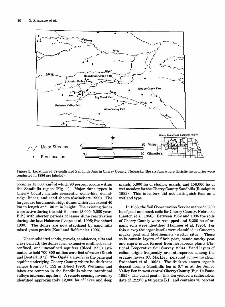
10 G. Steinauer et al.
•
•
• Goose Creek Fen
~ •
Pullman Valley Fen
Allen Valley Fen
•
• Cherry County and Sandhills Region
/\I Major Streams 20 o
• Fen Location 30 o 30 KilolllEiers
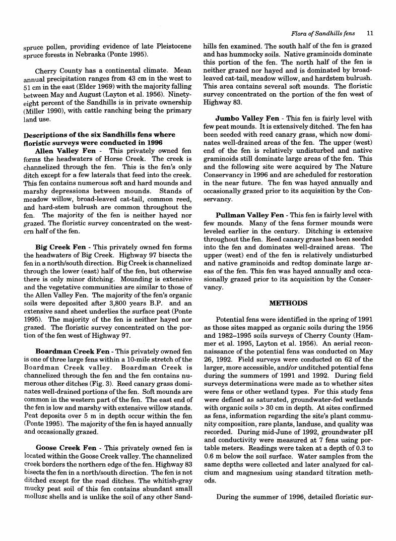
Figure 1. Locations of 39 confinned Sandhills fens in Cherry County, Nebraska (the six fens where floristic inventories were conducted in 1996 are labeled).
occupies 15,500 km2 of which 90 percent occurs within the Sandhills region (Fig. 1). Major dune types in Cherry County include crescentic, dome-like, domalridge, linear, and sand sheets (Swinehart 1990). The largest are barchanoid ridge dunes which can exceed 40 km in length and 130 m in height. The existing dunes were active during the mid-Holocene (8,000-5,000 years B.P.) with shorter periods of lesser dune reactivation during the late-Holocene (Loope et al. 1995; Swinehart 1990). The dunes are now stabilized by sand hills mixed-grass prairie (Kaul and Rolfsmeier 1993).
Unconsolidated sands, gravels, sandstones, silts and clays beneath the dunes form extensive confined, semiconfined, and unconfined aquifers (Bleed 1990) estimated to hold 700-800 million acre-feet of water (Keech and BentaIl1971). The Ogalala aquifer is the principal aquifer underlying Cherry County where its thickness ranges from 30 to 152 m (Bleed 1990). Wetlands and lakes are common in the Sandhills where interdunal valleys intersect aquifers. A remote sensing inventory identified approximately 12,000 ha of lakes and deep
marsh, 5,600 ha of shallow marsh, and 158,000 ha of wet meadow for the Cherry County Sandhills (Rundquist 1983). This inventory did not distinguish fens as a wetland type.
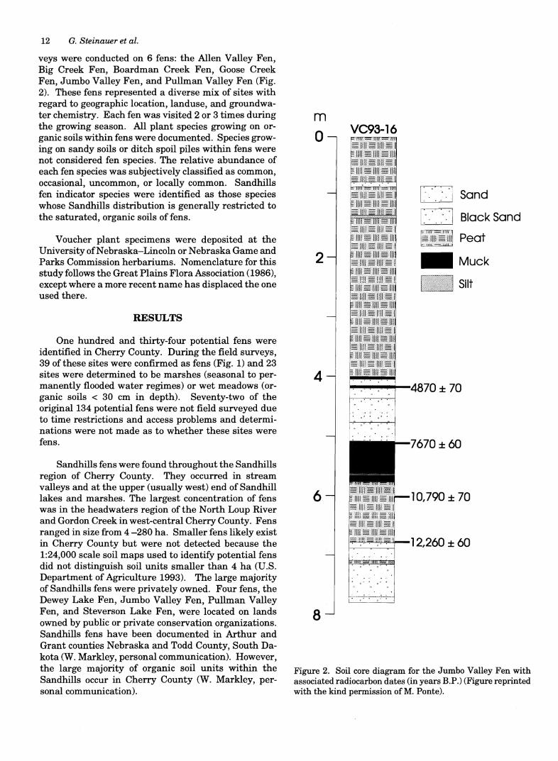
In 1956, the Soil Conservation Service mapped 9,200 ha of peat and muck soils for Cherry County, Nebraska (Layton et al. 1956). Between 1982 and 1995 the soils of Cherry County were remapped and 6,200 ha of organic soils were identified (Hammer et al. 1995). For this survey the organic soils were classified as Cutcomb mucky peat and Medihemists (wetter sites). These soils contain layers of fibric peat, hemic mucky peat and sapric muck formed from herbaceous plants (National Cooperative Soil Survey 1994). Sand layers of eolian origin frequently are interspersed among the organic layers (C. Markley, personal communication, Swinehart et al. 1995). The thickest known organic deposit from a Sandhills fen is 6.7 m at the Jumbo Valley Fen in west central Cherry County (Fig. 1) (Ponte 1995). The basal peat of this fen yielded a radiocarbon date of 12,260 ± 60 years B.P. and contains 70 percent
spruce pollen, providing evidence of late Pleistocene spruce forests in Nebraska (Ponte 1995).
Cherry County has a continental climate. Mean annual precipitation ranges from 43 cm in the west to 51 cm in the east (Elder 1969) with the majority falling between May and August (Layton et al. 1956). Ninetyeight percent of the Sandhills is in private ownership (Miller 1990), with cattle ranching being the primary land use.
Descriptions of the six Sandhills fens where floristic surveys were conducted in 1996
Allen Valley Fen - This privately owned fen forms the headwaters of Horse Creek. The creek is channelized through the fen. This is the fen's only ditch except for a few laterals that feed into the creek. This fen contains numerous soft and hard mounds and marshy depressions between mounds. Stands of meadow willow, broad-leaved cat-tail, common reed, and hard-stem bulrush are common throughout the fen. The majority of the fen is neither hayed nor grazed. The floristic survey concentrated on the western half ofthe fen.
Big Creek Fen - This privately owned fen forms the headwaters of Big Creek. Highway 97 bisects the fen in a north/south direction. Big Creek is channelized through the lower (east) half of the fen, but otherwise there is only minor ditching. Mounding is extensive and the vegetative communities are similar to those of the Allen Valley Fen. The majority ofthe fen's organic soils were deposited after 3,800 years B.P. and an extensive sand sheet underlies the surface peat (Ponte 1995). The majority of the fen is neither hayed nor grazed. The floristic survey concentrated on the portion of the fen west of Highway 97.
Boardman Creek Fen - This privately owned fen is one of three large fens within a 10-mile stretch ofthe Boardman Creek valley. Boardman Creek is channelized through the fen and the fen contains numerous other ditches (Fig. 3). Reed canary grass dominates well-drained portions of the fen. Soft mounds are common in the western part of the fen. The east end of the fen is low and marshy with extensive willow stands. Peat deposits over 5 m in depth occur within the fen (Ponte 1995). The majority ofthe fen is hayed annually and occasionally grazed.
Goose Creek Fen - This privately owned fen is located within the Goose Creek valley. The channelized creek borders the northern edge of the fen. Highway 83 bisects the fen in a north/south direction. The fen is not ditched except for the road ditches. The whitish-gray mucky peat soil of this fen contains abundant small mollusc shells and is unlike the soil of any other Sand-
Flora of Sandhills fens 11
hills fen examined. The south half of the fen is grazed and has hummocky soils. Native graminoids dominate this portion of the fen. The north half of the fen is neither grazed nor hayed and is dominated by broadleaved cat-tail, meadow willow, and hardstem bulrush. This area contains several soft mounds. The floristic survey concentrated on the portion of the fen west of Highway 83.
Jumbo Valley Fen - This fen is fairly level with few peat mounds. It is extensively ditched. The fen has been seeded with reed canary grass, which now dominates well-drained areas of the fen. The upper (west) end of the fen is relatively undisturbed and native graminoids still dominate large areas of the fen. This and the following site were acquired by The Nature Conservancy in 1996 and are scheduled for restoration in the near future. The fen was hayed annually and occasionally grazed prior to its acquisition by the Conservancy.
Pullman Valley Fen - This fen is fairly level with few mounds. Many of the fens former mounds were leveled earlier in the century. Ditching is extensive throughout the fen. Reed canary grass has been seeded into the fen and dominates well-drained areas. The upper (west) end of the fen is relatively undisturbed and native graminoids and redtop dominate large areas of the fen. This fen was hayed annually and occasionally grazed prior to its acquisition by the Conservancy.
METHODS
Potential fens were identified in the spring of 1991 as those sites mapped as organic soils during the 1956 and 1982-1995 soils surveys of Cherry County (Hammer et al. 1995, Layton et al. 1956). An aerial reconnaissance of the potential fens was conducted on May 26, 1992. Field surveys were conducted on 62 of the larger, more accessible, and/or unditched potential fens during the summers of 1991 and 1992. During field surveys determinations were made as to whether sites were fens or other wetland types. For this study fens were defined as saturated, groundwater-fed wetlands with organic soils> 30 cm in depth. At sites confirmed as fens, information regarding the site's plant community composition, rare plants, landuse, and quality was recorded. During mid-June of 1992, groundwater pH and conductivity were measured at 7 fens using portable meters. Readings were taken at a depth of 0.3 to 0.6 m below the soil surface. Water samples from the same depths were collected and later analyzed for calcium and magnesium using standard titration methods.
During the summer of 1996, detailed floristic sur-
12 G. Steinauer et al.
veys were conducted on 6 fens: the Allen Valley Fen, Big Creek Fen, Boardman Creek Fen, Goose Creek Fen, Jumbo Valley Fen, and Pullman Valley Fen (Fig. 2). These fens represented a diverse mix of sites with regard to geographic location, landuse, and groundwater chemistry. Each fen was visited 2 or 3 times during the growing season. All plant species growing on organic soils within fens were documented. Species growing on sandy soils or ditch spoil piles within fens were not considered fen species. The relative abundance of each fen species was subjectively classified as common, occasional, uncommon, or locally common. Sandhills fen indicator species were identified as those species whose Sandhills distribution is generally restricted to the saturated, organic soils of fens.
Voucher plant specimens were deposited at the University of Nebraska-Lincoln or Nebraska Game and Parks Commission herbariums. Nomenclature for this study follows the Great Plains Flora Association (1986), except where a more recent name has displaced the one used there.
RESULTS
One hundred and thirty-four potential fens were identified in Cherry County. During the field surveys, 39 of these sites were confirmed as fens (Fig. 1) and 23 sites were determined to be marshes (seasonal to permanently flooded water regimes) or wet meadows (organic soils < 30 cm in depth). Seventy-two of the original 134 potential fens were not field surveyed due to time restrictions and access problems and determinations were not made as to whether these sites were fens.
Sandhills fens were found throughout the Sandhills region of Cherry County. They occurred in stream valleys and at the upper (usually west) end of Sandhill lakes and marshes. The largest concentration of fens was in the headwaters region of the North Loup River and Gordon Creek in west-central Cherry County. Fens ranged in size from 4 -280 ha. Smaller fens likely exist in Cherry County but were not detected because the 1:24,000 scale soil maps used to identify potential fens did not distinguish soil units smaller than 4 ha (U.S. Department of Agriculture 1993). The large majority of Sandhills fens were privately owned. Four fens, the Dewey Lake Fen, Jumbo Valley Fen, Pullman Valley Fen, and Steverson Lake Fen, were located on lands owned by public or private conservation organizations. Sandhills fens have been documented in Arthur and Grant counties Nebraska and Todd County, South Dakota (W. Markley, personal communication). However, the large majority of organic soil units within the Sandhills occur in Cherry County (W. Markley, personal communication).
m o
2
4
6
8
VC93-16
C Sand
C BlackSand
~~f(IIE~!!lll Peat
_Muck
Silt
~~""",,*-LIR70 ± 70
. , . ~. . ~' .
7670 ± 60
10,790 ± 70
~~4-12,260 ± 60
Figure 2. Soil core diagram for the Jumbo Valley Fen with associated radiocarbon dates (in years RP.) (Figure reprinted with the kind permission ofM. Ponte).
Surface mounding was found to be characteristic of Sandhills fens. The mounds, up to 2 m in height and 1 ha in area, were circular to nearly linear in shape. Three types of mounds were identified: soft peat mounds, hard peat mounds, and sand mounds. Soft peat mounds are highly saturated areas of groundwater discharge that often quake underfoot. They apparently form from groundwater pressure pushing the surface peat upward and from excess peat accumulation near the seeps. Soft mounds can form in a relatively short period of time as a result of a groundwater pressure. A series of rather high mounds on the Boardman Creek Fen have developed since the 1950s (R. Ravenscroft, personal communication). When examined in 1992, one of these mound had a surface peat layer about 0.6 m thick below which was a pool of water at least 1.5 m deep -it's bottom could not be reached with a spade. Hard peat mounds contain firmer peat and are less saturated than soft peat mounds. They are sometimes areas of groundwater discharge. Sand mounds consist entirely of sand or sand overlain by a layer of peat. The latter are difficult to distinguish from hard peat mounds. The pH of Sandhills fens ranged from 6.0 to 6.9, while conductivity ranged from 99 to 780 (mohmlcm), Ca ranged from 8.0 to 115.2 mg/l, and Mg ranged from 4.9 to 13.7 mg/l (Table 1).
One hundred and ninety-one species and one subspecies of vascular plants were recorded for the six Sandhills fens surveyed in 1996 (Table 2). The most commonly represented families were the Cyperaceae (29 species), Poaceae (28 species), and Asteraceae (25 species and one subspecies). Twenty-one species (11 percent) were Nebraska Natural Heritage Program element-species (plants possibly rare in Nebraska) and 22 species (11 percent) were exotics. Sixty-six of the 192 taxa were ubiquitous to all six fens and 35 taxa were restricted to only one fen.
Sandhills fen indicator species included bog aster (Aster borealis), flat-top aster CA. umbellatus var. pubens), marsh marigold (Caltha palustris), water sedge (Carex aquatilis), mud sedge (C. limosa), prairie sedge
Table 1. Groundwater conductivity, pH, Ca and Mg levels for seven Sandhills fens in Cherry County, Nebraska.
Conductivity Ca Mg Fen Name mohmlcm pH mg/l mg/l
Allen Valley Fen 99 6.0 8.0 4.9 Big Creek Fen 101 6.0 9.6 7.8 Boardman Creek Fen 150 6.0 16.0 7.8 CanetFen 164 6.6 24.0 13.7 Carver Creek Fen 132 6.0 12.8 8.8 Goose Creek Fen 780 6.9 115.2 13.7 Jumbo Valley Fen 108 6.4 12.8 6.8
Flora of Sandhills fens 13
(C. prairea), cottongrass (Eriophorum angustifolium), slender cottongrass (E. gracile), bottle gentian (Gentiana andrewsii), wild lily (Lilium philadelphicum), bog buckbean (Menyanthes trifoliata), bog muhly (Muhlenbergia glomerata), adder's tongue (Ophioglossum pusillum), swamp lousewort (Pedicularis lanceolata), and marsh St. John's-wort (Triadenum fraseri). These species grew most frequently on soft peat mounds, but occasionally were found in other fen habitats.
The vegetation pattern of undisturbed Sandhills fens was heterogenous with mounds interspersed with low marshy areas, shrub patches, and open meadow" like areas (Fig. 3). Soft peat mounds had high plant species diversity and were often dominated by spikesedge (Eleocharis elliptica), prairie sedge (Carex prairea), C. interior, hard-stem bulrush (Scirpus acutus), and marsh fern (Thelypteris palustris). The vegetation of hard peat mounds was less diverse than soft mounds. Hard mounds were sometimes dominated by near mono culture stands of common reed (Phragmites australis). Sand mounds within fens supported species typical of Sandhi lIs wet meadows. Low marshy areas within Sandhills fens were dominated by ripgut sedge (C. lacustris), water smartweed (Polygonum amphibium), arrowhead (Sagittaria latifolia), hard-stem bulrush, burreed (Sparganium eurycarpum), and broad-leaved cattail (Typha latifolia). These species are common in Sandhill marshes. Meadow willow (Salix petiolaris) was the dominant shrub in Sandhills fens and often formed dense patches. Other fen shrubs included American currant (Ribes americanum), red osier (Cornus sericea), and false indigo CAmorpha fruticosa). Herbaceous cover beneath the shrubs was usually sparse with the most abundant species being marsh fern, sensitive fern (Onoclea sensibilis), touch-me-not (Impatiens capensis), and spikesedge. Meadow-like areas within fens were dominated by blue joint (Calamagrostis canadensis), prairie cordgrass (Spartina pectinata), sedges (Carex spp.), and spikesedge. These graminoids also were dominant in hayed fens along with several exotic species including redtop, (Agrostis stolonifera),
Table 2. Fen size and number of vascular, exotic, and rare plant species for six Sandhills fens in Cherry County, Ne-braska.
Tot. Plants Size (species Exotic Element
Fen Name (ha) & subsp.) spp. spp.
Allen Valley Fen 138 126 11 11 Big Creek Fen 174 122 9 15 Boardman Creek Fen 200 136 11 14 Goose Creek Fen 70 112 4 13 Jumbo Valley Fen 100 128 19 14 Pullman Valley Fen 256 119 14 11 Total 192 22 21
14 G. Steinauer et al.
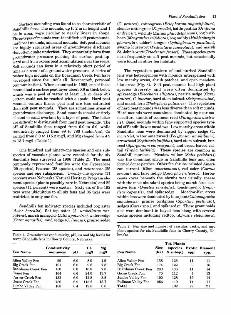
Figure 3. A. The Allen Valley Fen (bordered by a hayed wet meadow). B. Boardman Creek Fen showing extensive ditching.
timothy (Phleum pratense), Kentucky bluegrass (Poa pratensis), reed canary grass (Phalaris arundinacea), and various clovers (Trifolium spp.). Reed canary grass formed dense, near mono culture stands in many hayed fens where ditching has lowered groundwater levels.
Annotated list Vascular plant species and subspecies listed by
family for the six Sandhills fens surveyed in 1996 along with relative abundance, habitat, and location comments. Locations are represented by the following symbols: A - Allen Valley Fen, Bg - Big Creek Fen, Bd -Boardman Creek Fen, G - Goose Creek Fen, J - Jumbo Valley Fen, and P - Pullman Valley Fen. An "*,, designates a Nebraska Natural Heritage Program element species.
Alismataceae
Alisma subcordatum Raf. [including A. triuialel (water plantain) - uncommon in shallow water (Bd, G, P).
Sagittaria latifolia Willd. (arrowhead) - common (all).
Apiaceae
Berula erecta (Huds.) COy. var. incisum (Torr.) Cronq. (water parsnip) - occasional in ditches and spring holes (A, Bg, Bd, P). '
Cicuta bulbifera* L. (bulbous water hemlock) - uncommon to locally common (G, J).
Cicuta maculata L. (common water hemlock) - occasional (all).
Sium suave Walt. (water parsnip) - occasional in ditches (all).
Apocynaceae
Apocynum cannabinum L. (hemp dogbane) - uncommon (A, Bg, J).
Asclepiadaceae
Asclepias incarnata L. (swamp milkweed) - occasional (all). Asclepias speciosa Torr. (showy milkweed) - uncommon on
hard peat mound (G).
Asteraceae
Achillea millefolium L. (yarrow) - occasional at fen margins (A, Bd, P)
Ambrosia artemisiifolia L. (common ragweed) - occasional at fen margins, hard peat mounds, ditch banks (Bg Bd J, P). ' ,
Aster borealis* (T. & G.) Provo [A. junciformisl (bog aster) -common (all).
Aster lanceolatus Willd. ssp. hesperius (A. Gray) Semple & Chmielewski [A. hesperiusl (panicled aster) - common (all).
Aster lanceolatus Willd. ssp. lanceolatus [A. simplex var. ramosissimusl (panicled aster) - uncommon (Bd).
Aster pans us (Blake) Cronq. -locally common (G). Aster praealtus Poir. var. nebraskensis (Britt.) Wieg.
(willowleaf aster) - common (all). Asterumbellatus* P. Mill. var.pubens A. Gray [A.pubentior]
(flat-top aster) - locally common (all).
Flora of Sandhills fens 15
Bidens cernua L. (nodding beggar-ticks) - common in ditches and spring holes (all).
Bidens connata Muhl. ex Willd. (beggar-ticks) - uncommon (P).
Bidens coronata (L.) Britt. (tickseed sunflower) - common (all).
Bidens frondosa L. (beggar-ticks) - occasional (Bd, P). Bidens vulgata Greene (beggar-ticks) - uncommon (Bd). Cirsium arvense (L.) Scop. (Canada thistle) - uncommon on
ditch bank (J). Exotic. Cirsium vulgare (Savi) Ten. (bull thistle) - uncommon on
ditch banks (J, P). Exotic. Eupatorium maculatum L. var. bruneri (A. Gray) Breitung
(joe-pye weed) - common (all). Eupatorium perfoliatum L. (boneset) - occasional to com
mon (A, Bg, Bd, G). Euthamia gymnospermoides Greene (viscid euthamia) -
uncommon along fen margin (P). Helenium autumnale L. (sneezeweed) - uncommon along
fen margins, hard peat mounds (Bg, Bd, G). Helianthus nuttallii T. & G. (Nuttall's sunflower) - com
mon (all). Some larger individuals are close to H. grosseserratus Martens.
Liatris lancifolia (Greene) Kittell (tall gayfeather) - uncommon along fen margins (G).
Rudbeckia hirta L. (black-eyed Susan) - occasional (all). Solidago canadensis L. (Canada goldenrod) - occasional
(all). Solidago gigantea Ait. (late goldenrod) - occasional (all). Solidago rigida L. (stiff goldenrod) - uncommon (Bd, G, J). Taraxacum officinale Weber (dandelion) - uncommon to
occasional (A, G, J, P). Exotic.
Balsaminaceae
Impatiens capensis Meerb. (spotted touch-me-not) -locally common in ditches and spring holes (all).
Brassicaceae
Barbarea vulgaris R. Br. (winter cress) - occasional (J, P). Exotic.
Cardamine pensylvanica* Muhl. (bitter cress) - uncommon to locally common around spring holes (J, P).
Thlaspi arvense L. (pennycress) - uncommon (J, P). Exotic.
Campanulaceae
Campanula aparinoides Pursh (marsh bellflower) - common (all).
Lobelia siphilitica L. (blue cardinal flower) - common (all).
Caryophyllaceae
Cerastium brachypodum (Engelm. ex A. Gray) Robins. -uncommon (J).
Cerastium fontanum Baumg. ssp. vulgare (Hartman) Greuter & Burdet [C. uulgatuml - uncommon (Bg, Bd). Exotic.
Stellaria longifolia Muhl. ex Willd. (long-leaved stitchwort) - common (all).
Clusiaceae
Hypericum majus (A. Gray) Britt. (greater St. John's-wort) - uncommon (A, Bg).
Triadenum fraseri* (Spach) Gl. (marsh St. John's-wort) -locally common (A, Bg, Bd, J, P).
16 G. Steinauer et al.
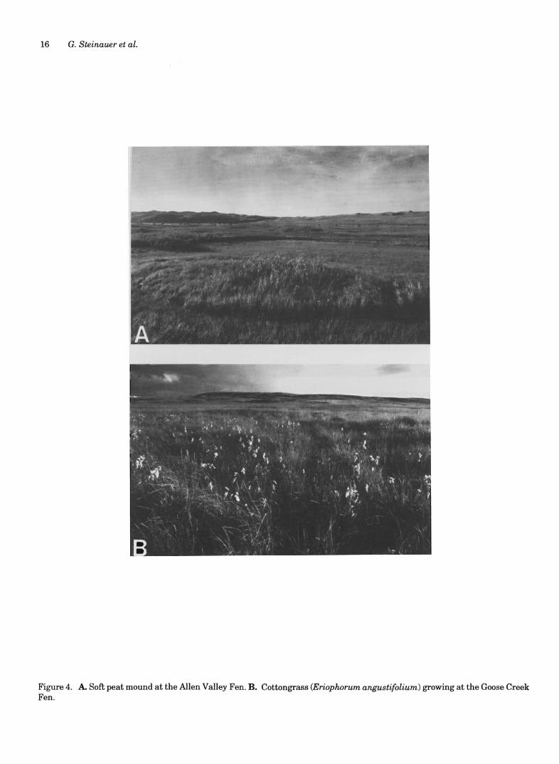
Figure 4. A. Soft peat mound at the Allen Valley Fen. B. Cottongrass (Eriophorum angustifolium) growing at the Goose Creek Fen.
Cornaceae
Comus sericea L. [C. stolonifera] (red osier) - uncommon (Bd).
Crassulaceae
Penthorum sedoides L. (ditch stonecrop) - uncommon (A, Bd, J).
Cupressaceae
Juniperus virginiana L. (eastern red cedar) - uncommon (G).
Cuscutaceae
Cuscuta glomerata Choisy (dodder) - occasional on hard mounds, mostly on Asteraceae, particularly Solidago gigantea (A, Bg, Bd, G).
Cuscuta indecora Choisy (large alfalfa dodder) - uncommon on hard mounds, on Helianthus nuttallii (Bd).
Cyperaceae
Carex aquatilis* Wahl. var substricta Kiikenth. (water sedge) -locally common (Bg, Bd, J, P).
Carex comosa F. Boott - locally common in ditches and spring holes (A, Bg, J, P).
Carex diandra* Schrank - uncommon (Bg, G). Carex emoryi Dew. - occasional (A, Bg, Bd, G). Carex hysteric ina Muhl. ex Willd. (bottlebrush sedge) -
occasional (A, Bg, Bd, G). Carex interior Bailey - common (all). Carex lacustris Willd. (ripgut sedge) - common (all). Carex limosa* L. (mud sedge) - uncommon to locally com
mon(Bd, G). Carex nebrascensis Dew. - common (all). Carex pellita Muhl. [C. lanuginosa, misapplied] (woolly
sedge) - common (all). Carex prairea* Dew. (prairie sedge) - common (all). Carex sartwellii Dew. - occasional to common (all). Carex scoparia Schkuhr ex Willd. - common (A, Bg, Bd, J,
P). Carex stipata Muhl. - occasional (all). Carex tetanica Schkuhr - occasional (all). Carex vulpinoidea Michx. - occasional (A, Bg, G). Cyperus bipartitus Torr. [C. rivularis] (brook flats edge) -
uncommon to locally common (Bg, G, J). Cyperus strigosus L. - occasional (A, Bg, Bd, G, J). Dulichium arundinaceum* (L.) Britt. - uncommon (Bg,
Bd). Eleocharis acicularis (L.) R. & S. (hairgrass) - occasional
(A, Bd, G, J). Eleocharis elliptica Kunth [E. compressa, misapplied]
(spikesedge) - common (all). Eleocharis erythropoda Steud. (spikesedge) - occasional,
often in ditches (A, Bd, G, J, P). Eriophorum angustifolium* Honck. [E. polystachion]
(cottongrass) - common (all). Eriophorum gracile* Koch (slender cottongrass) - locally
common (A, Bg, G). Scirpus acutus Muhl. (hardstem bulrush) - common (all). Scirpus fluviatilis (Torr.) A. Gray (river bulrush) - uncom
mon in ditches (Bd). Scirpus pallidus (Britt.) Fern. (darkgreen bulrush) - occa
sional (A, Bg, Bd, G, P).
Flora of Sandhills fens 17
Scirpus pungens Vahl (three-square bulrush) - occasional to locally common (all).
Scirpus validus Vahl (softstem bulrush) - occasional, especially along ditches (all).
Equisetaceae
Equisetum arvense L. (field horsetail) - uncommon (A, Bg, Bd).
Fabaceae
Amorpha fruticosa L. (false indigo) - uncommon (Bd). Desmodium canadense (L.) DC. (Canada tickclover) - un
common along margin offen (Bg, P). Lotus unifoliatus (Hook.) Benth. [L. purshianus] (prairie
trefoil) - uncommon along margin offen (Bd). Medicago lupulina L. (black medic) - uncommon (A, Bd, J).
Exotic. Melilotus alba Medic. (white sweet clover) - uncommon (J).
Exotic. Melilotus officinalis (L.) Pall. (yellow sweet clover) - un
common (A, Bd). Exotic. Trifolium hybridum L. (alsike clover) - occasional (A, Bg,
Bd, J, P). Exotic. Trifoliumpratense L. (red clover) - occasional (A, Bg, Bd, J,
P). Exotic. Trifolium repens L. (white clover) - occasional (A, Bg, J, P).
Exotic.
Gentianaceae
Gentiana andrewsii Griseb. (bottle gentian) - uncommon (A, Bg, Bd, J).
Grossulariaceae
Ribes americanum P. Mill. (wild black currant) - uncommon (all).
lridaceae
Sisyrinchium montanum Greene (blue-eyed grass) - uncommon (A, Bg, G, J, P).
Juncaceae
Juncus articulatus* L. - uncommon (G). Juncus balticus Willd. - occasional to locally common (all). Juncus canadensis* Gay ex Laharpe - uncommon to com-
mon (Bg, Bd, J, P). Juncus dudleyi Wieg. - occasional (all). Juncus marginatus Rostk. (grassleaf rush) - uncommon at
fen margin (P). Juncus nodoBus L. (knotted rush) - occasional (A, Bg, Bd, G,
J).
Juncaginaceae
Triglochin maritimum L. (arrow grass) - locally common (G).
Lamiaceae
LyCOpUB americanus Muhl. ex Bart. (water horehound) -occasional (all).
Lycopus asper Greene (rough bugleweed) - uncommon on hard mounds (G, J).
Lycopus uniflorus Michx. (one-flower horehound) - common (all).
Mentha arvensiB L. (field mint) - common (all).
18 G. Steinauer et al.
Nepeta cataria L. (catnip) - uncommon on hard mounds and ditch banks (Bd, J). Exotic.
Scutellaria galericulata L. (marsh skullcap) - common (all).
Scutellaria lateriflora L. (blue skullcap) - occasional (all). Stachys palustris L. ssp. pilosa (Nutt.) Epl. (hedge nettle)
- uncommon on hard mounds (G). Teucrium canadense L. var. occidentale (A. Gray) McCl.
& Epl. [T. canadense var. boreale1 (American germander) - uncommon (G, P).
Lemnaceae
Lemna minor L. s. I. (duckweed) - common in ditches and spring holes (all).
Liliaceae
Hypoxis hirsuta (L.) COy. (yellow stargrass) - occasional (A, Bg, Bd, G).
Lilium philadelphicum * L. (wild lily) - uncommon on peat mounds (A, Bg, Bd, G, J).
Maianthemum stellatum (L.) Link [Smilacina stellata1 (false Solomon's seal) - uncommon on peat mounds (Bd, G).
Lytbraceae
Lythrum alatum var. alatum Pursh (winged loosestrife)occasional (A, G).
Menyanthaceae
Menyanthes trifoliata* L. (bog buckbean) - uncommon to common (Bd, G, J).
Onagraceae
Epilobium ciliatum Raf. (willow-herb) - occasional around seep holes (A, Bg, P).
Epilobium coloratum Biehler (purple-leaved willow-herb) -occasional around seep holes (A, Bg, J, P).
Epilobium leptophyllum Raf. (narrow-leaved willow-herb) - common (all).
Ludwigia palustris (L.) Ell. (marsh seedbox) - uncommon in ditches (P).
Oenothera villosa Thunb. (common evening primrose) -occasional (A, Bg, Bd, J, P).
Ophioglossaceae
Ophioglossum pusillum* Raf. [0. vulgatum var. pseudopodum1 (adder's-tongue) - uncommon (A, Bg, J).
Orchidaceae
Liparis loeselii* (L.) Rich. (twayblade) - uncommon (Bg). Spiranthes cernua (L.) Rich. Oady's-tresses) - uncommon to
occasional (A, Bg, Bd, J, P).
Plantaginaceae
Plantago major L. (plantain) - uncommon (G, J). Exotic.
Poaceae
Agrostis scabra Willd. (ticklegrass) - occasional to common (all).
Agrostis stolonifera L. (redtop) - common (all). Exotic. Alopecurus aequalis Sobol. (short-awn foxtail) - occasional
(A, P). Andropogon gerardii Vitman (big bluestem) - uncommon
on hard mounds (Bg).
Beckmannia syzigachne (Steud.) Fern. (American sloughgrass) - uncommon along ditches (A, Bd, J).
Bromus ciliatus L. (fringed brome) - occasional to locally common (all).
Bromus inermis Leyss. ssp. inermis (smooth brome) - uncommon along fen margins (Bd). Exotic.
Calamagrostis canadensis (Michx.) Beauv. (bluejoint) -common (all).
Calamagrostis stricta (Timm) Koel. (northern reedgrass) -occasional (all).
Dichanthelium acuminatum (Sw.) Gould & Clark (spring panicum) - uncommon (P).
Echinochloa muricata (Beauv.) Fern. var. microstachya Wieg. (barnyard grass) - uncommon to occasional (Bg, Bd, G,J, P).
Elymus canadensis L. (Canada wildrye) - uncommon on hard mounds (A, P).
Elymus trachycaulus (Link) Gould ex Shinners ssp. trachycaulus [Agropyron caninum ssp. majus var. mqjus1 (slender wheatgrass) - uncommon along fen margins (Bd).
Glyceria grandis S. Wats. ex A. Gray (tall mannagrass) -occasional (A, Bg, Bd, J, P).
Glyceria striata (Lam.) Hitchc. (fowl mannagrass) - common (all).
Hordeumjubatum L. (foxtail barley) - uncommon to occasional along fen margins (A, Bg, Bd, G, J).
Leersia oryzoides (L.) Sw. (rice cutgrass) -locally common in ditches (all).
Muhlenbergia glomerata* (Willd.) Trin. - occasional to locally common (all).
Muhlenbergia mexicana (L.) Trin. - uncommon to occasional (Bg, Bd, G, J, P).
Panicum capillare L. (witchgrass) - uncommon on hard mounds (A, G).
Phalaris arundinacea L. (reed canary grass) - locally common along fen margins (Bg, Bd, J, P). Exotic.
Phleum pratense L. (timothy) - occasional (A, Bg, Bd, J, P). Exotic.
Phragmites australis (Cav.) Trin. ex Steud. (common reed) - locally common on hard mounds (all).
Poa palustris L. (fowl bluegrass) - occasional (A, Bg, Bd, J, P). Exotic.
Poa pratensis L. (Kentucky bluegrass) - occasional to common (all). Exotic.
Sorghastrum nutans (L.) Nash (Indian grass) - occasional on hard mounds and along fen margins (A, Bg, Bd, G).
Spartina pectinata Link (prairie cordgrass) - occasional to common (all).
Sphenopholis obtusata (Michx.) Scribn. var. obtusata (prairie wedgegrass) - uncommon (A, G).
Polygonaceae
Polygonum amphibium L. (water smartweed) - common (all).
Polygonum coccineum Muhl. [Po amphibium var. emersum1 (swamp smartweed) - occasional to common (all).
Polygonum hydropiper L. (water pepper) - uncommon in ditches and around spring holes (J, P). Exotic.
Polygonum lapathifolium L. (nodding willow-weed) - locally common in ditches and spring holes (all).
Polygonum persicaria L. Oady's-thumb) - uncommon in ditches (A, Bd, J, P). Exotic.
polygonum punctatum Ell. (water smartweed) - locally common in spring holes (A, Bg, Bd, P).
polygonum sagittatum L. (tear-thumb) - locally common around spring holes (A, Bg, Bd, J, P).
Rumex orbiculatus Gray (great water dock) - locally common around spring holes (all).
Polypodiaceae
Onoclea sensibilis L. (sensitive fern) - uncommon to common (A, Bg, Bd, P).
Thelypteris palustris Schott (marsh fern) - common (all).
Primulaceae
Lysimachia ciliata L. (fringed loosestrife) - uncommon (A, Bg, J).
Lysimachia thyrsiflora L. (tufted loosestrife) - common (all).
Ranunculaceae'
Caltha palustris* L. (marsh marigold) - uncommon to common (A, Bg, Bd, J, P).
Ranunculus cymbalaria Pursh (shore buttercup) - uncommon (G).
Ranunculus pensylvanicus L. f. (bristly crowsfoot) - uncommon, often along ditches (A, Bd, J, P).
Ranunculus sceleratus L. var. multifidus Britt. (cursed crowsfoot) - uncommon (J, P).
Thalictrum dasycarpum Fisch. & Ave-Lall. (meadow rue)occasional (Bd).
Rosaceae
Geum aleppicum Jacq. (yellow avens) - uncommon to occasional (A, Bg, Bd, J, P).
Potentilla norvegica L. (Norwegian cinquefoil) - uncommon on ditch banks (J, P).
Potentilla rivalis Nutt (brook cinquefoil) - uncommon (Bd, J, P).
Rosa woodsii Lind!. (western wild rose) - uncommon on peat mound (G).
Rubiaceae
Galium aparine L. (catchweed bedstraw) - uncommon (A). Galium trifidum L. s. l. (small bedstraw) - occasional to
common (all).
Salicaceae
Salix amygdaloides Anderss. (peach-leaved willow) - uncommon in ditches (A, Bd).
Salix petiolaris J. E. Sm. (meadow willow) - common (all). Salix rigida Muhl. var. watsonii (Bebb) Cronq. [So lutea,
misapplied] (diamond willow) - uncommon (Bg).
Scrophulariaceae
Agalinis tenuifolia (Vahl) Raf. var. parviflora (Nutt.) Penn. (gerardia) - occasional (Bg, Bd, G, J, P).
Mimulus glabratus H. B. K. var. fremontii (Benth.) A. L. Grant (roundleaf monkey flower) - occasional in spring holes (A, Bg, J).
Mimulus ringens L. (Allegheny monkey flower) - uncommon in spring holes (Bd, J).
Pedicularis lanceolata* Michx. (swamp lousewort) - occasional to locally common (A, Bd, G).
Veronica peregrina L. var. xalapensis (H. B. K.) St. John
Flora of Sandhills fens 19
& Warren (purslane speedwell) - uncommon (Bg, P).
Sparganiaceae
Sparganium eurycarpum Engelm. (bur-reed) -locally common in spring holes and ditches (all).
Typhaceae
Typha latifolia L. (broad-leaved cat-tail) - common (all).
Urticaceae
Boehmeria cylindrica (L.) Sw. (false nettle) - uncommon to locally common (A, Bd).
Parietaria pensylvanica Muhl. (Pennsylvania pellitory) -uncommon (G, J).
Pilea fontana (Lunell) Rydb. (clearweed) - locally common in spring holes (all).
Urtica dioica L. ssp. gracilis (Ait.) Seland. (stinging nettle) - occasional on hard mounds and ditch banks (A, Bd, J).
Verbenaceae
Verbena hastata L. (blue vervain) - occasional (A, Bg, Bd, G, J).
Violaceae
Viola nephrophylla Greene - (northern bog violet) common (all).
Vitaceae
Parthenocissus vitacea (Knerr) Hitchc. (woodbine) - uncommon (Bd).
DISCUSSION
According to Ponte (1995), organic soil accumulation in the oldest Sandhills fens began in the late Pleistocene and continued into the early Holocene. Between 8,000 and 5,000 years B.P. significant drought and eolian activity caused cessation of organic soil accumulation and deposition of sand sheets over a significant portion of Sandhills fens. Organic soil accumulation in fens resumed around 5,000 B.P. with the return of mesic conditions. Many Sandhills fens, as well as other fens in the Midwest (Glaser 1987, Pearson and Leoschke 1992), appear to have initiated development at this time. Organic soil accumulation continued in Sandhills fens through the late Holocene, though radiocarbon dating at the base of sand layers in several fens suggests periods of drought and eolian activity between 3,500 and 2,800 years B.P. and sometime slightly after 1,000 years B.P. Sand mounds were deposited in many fens during these periods. Those mounds later saturated by groundwater developed a surface covering of peat.
Several Sandhills fen indicator species including bog aster, flat-top aster, water sedge, mud sedge, cottongrass, slender cottongrass, and bog muhly are found in Nebraska only in Sandhills fens and no other habitats. The other indicator species are occassionally found in other Nebraska habitats. For example, the
20 G. Steinauer et al.
authors have collected adder's tongue from a spring seep in the Niobrara River valley in northern Cherry County and bog buckbean from a sandy shallow stream bed and marsh in the Cherry County Sandhills. Marsh marigold has been collected from 3 northeast Nebraska counties (Great Plains Flora Association 1977), likely in seepage communities. The Sandhills populations of most fen indicator species (e.g. mud sedge, cottongrass, and slender cottongrass) are disjunct from their primary ranges to the north and east of the Great Plains (Great Plains Flora Association 1977). These populations are likely relicts from the late Pleistocene when the species were distributed widely over Nebraska's periglacial landscape. How these species survived periods of Holocene drought and dune movement in the Sandhills is open to speculation. Portions of Sandhills fens with strong seepage may have been unaffected by the drifting sands and provided a refugium for the plants.
Soil aeration and pH-nutrient regimes are the most important environmental factors affecting the vegetation and flora of peatlands (Jeglum 1971). This study did not examine soil aeration levels within Sandhills fens and the water chemistry sampling was insufficient to make detailed correlations between fen vegetation and water chemistry. However, there is some evidence that water chemistry influences Sandhills fen vegetation. The Goose Creek Fen, with the highest pH among the sampled fens, contained 3 alkaline-tolerant species, arrow grass (Triglochin maritimum),Aster pansus, and tall gayfeather (Liatris lancifolia), which were not found in the other Sandhill fens. Other factors likely influencing the vegetation and flora of Sandhills fens include soil type (muck, mucky peat, or peat), depth and thickness of underlying sand layers, and past and present landuse.
Haying is the predominant landuse of Sandhills fens. Ditching and drainage offens to facilitate haying began as early as the late 1800s with shovels, horsedrawn scrapers and dynamite (Steinauer 1992). After World War II, a surplus of heavy equipment was available and this greatly increased the rate and effectiveness of ditching. The extent of ditching varies among fens. Some contain only a single main ditch while others contain 1 to several main ditches and numerous laterals. Nearly all perennial streams flowing through fens have been channelized. After being ditched, fens were often cleared of shrubs by chaining, bulldozing, herbicide spraying, and burning and their peat mounds leveled to further facilitate haying.
Ditching impacts Sandhills fens by lowering surface and groundwater levels and possibly by altering groundwater flow patterns. When allowed to dry, organic soils quickly decompose through oxidation. De-
composition and compaction of organic soils is evident in many Sandhill fens by a drop in the elevation of the soil surface adjacent to ditches. It is speculated that many shallow organic soil deposits in Cherry County have totally decomposed in recent decades due to ditching (W. Markley, personal communication). This may partially explain why 3,000 fewer hectares of organic soils were mapped in Cherry County in 1982-95 (Hammer et al. 1995) than in 1956 (Layton et al 1956).
Most ditched Sandhills fens have been seeded with exotic cool-season grasses and legumes to improve hay quality. Traditional mid- to late-summer annual haying promotes the exotics at the expense of native fen plants. These exotics are far less abundant in unditched, less hydrologically disturbed fens. Sandhills fens are occasionally grazed with cattle. Cattle generally avoid wet or soft areas of fens and limit their grazing to fen margins and areas adjacent to ditches. Trampling by cattle has caused hummocks and ruts to form in the organic soils of some fens. Ranchers often prefer to winter graze fens when soils are frozen and more accessible to cattle and less susceptible to damage.
Sandhills fens are a unique wetland type in N ebraska. Their ancient and fragile organic soils support an unusual assemblage of plants not found in other Nebraska wetlands. The biological integrity of these rare wetlands is being threatened by human manipulations that facilitate hay production and to a lesser extent grazing. Because of these factors, protection and restoration of Sandhills fens should be a conservation priority in Nebraska.
ACKNOWLEDGMENTS
We would like to thank Jennifer Delisle, Roger Hammer, Chuck Markley, Rick Schneider and Jim Swinehart for reviewing drafts of this manuscript. We also thank the Sandhill ranchers who allowed us access to their property and shared their knowledge of the Sandhills. Marian Borgmann-Ingwersen of Wayne State College provided several records from Big Creek, Jumbo Valley, and Pullman Valley fens.
Funding for the 1991-1992 portion ofthe study was provided by the U.S. Fish and Wildlife Service's Biodiversity Fund (Agreement No. 14-16-0006-91-909) and the Nebraska Game and Parks Commission. Funding for the 1996 field surveys were provided by The Nature Conservancy and Nebraska Game and Parks Commission.
LITERATURE CITED
Bates, J. M. 1914. On the sedges of Nebraska (family Cyperaceae). University of Nebraska Studies 14(2): 145-165.
Bleed, A. 1990. Groundwater. In: A Bleed and C. Flowerday (eds.), Atlas of the Sand Hills. Resource Atlas No. 5a. University of Nebraska-Lincoln, Conservation and Survey Division: 67-92
_, and C. Flowerday. 1990. Introduction. In: A. Bleed and C. Flowerday (eds.), Atlas of the Sand Hills. Resource Atlas No. 5a. University of Nebraska-Lincoln, Conservation and Survey Division: 1-16
Clausen, M., M. Fritz, and G. Steinauer. 1989. The Nebraska Natural Heritage Program two-year progress report. Lincoln, Nebraska Game & Parks Commission: 154 pp.
Elder, J. A 1969. Soils of Nebraska. Resource Report No.2. University of Nebraska-Lincoln, Conservation and Survey Division: 60 pp.
Glaser, J. H. 1987. The ecology of patterned boreal peatlands of northern Minnesota: A community profile. United States Fish and Wildlife Service Report 85(7.14): 98 pp.
Great Plains Flora Association. 1977. Atlas of the flora of the Great Plains. Ames, Iowa State University Press: 600 pp.
--. 1986. Flora of the Great Plains. Lawrence, University Press of Kansas: 1392 pp.
Hammer, R, W. Markley, and C. Latta. 1995. Soil survey of Cherry County, Nebraska. United States Department of Agriculture Natural Resources Conservation Service in cooperation with the University of Nebraska-Lincoln, Conservation and Survey Division. Unpublished report (advance copies subject to change).
Jeglum, J. K. 1971. Plant indicators of pH and water level in peatlands at Candle Lake, Saskatchewan. Canadian Journal of Botany 49: 1661-1676.
Kaul, R B., and S.B. Rolfsmeier. 1993. Native Vegetation of Nebraska. University of Nebraska-Lincoln, Conservation and Survey Division: 1 pp. map 1:1,000,000.
Keech, C. E., and R Bentall. 1971. Dunes on the plains. Resource Report No.4. University of Nebraska-Lincoln, Conservation and Survey Division.
Layton, M., C. Buzzard, and H. Hoy. 1956. Soil survey of Cherry County, Nebraska. Washington, D. C., United States Department of Agriculture: 91 pp.
Loope, D.L., J.B. Swinehart, and J.P. Mason. 1995.
Flora of Sandhills fens 21
Dune-dammed paleovalleys of the Nebraska Sandhills - intrinsic versus climatic controls on the accumulation of lake and marsh sediments. Geological Society of America Bulletin 107: 396-406.
Miller, S. 1990. Land development and use. In: A Bleed and C. Flowerday (eds.), Atlas of the Sand Hills. Resource Atlas No. 5a. University of Nebraska-Lincoln, Conservation and Survey Division: 207-226.
National Cooperative Soil Survey. 1994. Official series description of the Cutcomb Series. Valentine, Nebraska, Cherry County Soil Conservation Survey Office: 5 pp.
Nature Conservancy. 1994. Rare plant communities of the conterminous United States, an initial survey. Arlington, Virginia: 620 pp.
Pearson, J. A, and M. J. Leoschke. 1992. Floristic composition and conservation status off ens in Iowa. Journal of the Iowa Academy of Science 99(2-3): 41-52.
Ponte, M. R 1995. Eolian origin of sand within interdune peat, central Nebraska sand hills. University of Nebraska-Lincoln. Unpublished masters thesis. 74 pp. plus appendices.
Rundquist, D. 1983. Wetland inventories of Nebraska's Sandhills. Nebraska Remote Sensing Center, Resource Report No.9. University of Nebraska-Lincoln, Conservation and Survey Division: 46 pp.
Steinauer, G. A 1992. Sandhills fens. NEBRASKAland 70(6): 16-31.
Swinehart, J. B. 1990. Wind-blown deposits. In A Bleed and C. Flowerday (eds.), Atlas of the Sand Hills. Resource Atlas No. 5a. University of Nebraska-Lincoln, Conservation and Survey Division: 43-56
---, W.C. Markley, D. B. Loope, and M. R Ponte. 1995. The last 1000 years in the Nebraska Sand Hills: a history of sporadic blowouts or regional episodes of sand mobilization? Abstracts of The Geological Society of America, North Central and South Central Sections 27(3): 89.
Tolstead, W. L. 1942. Vegetation ofthe northern part of Cherry County, Nebraska. Ecological Monographs 12(2): 257-292.
United States Department of Agriculture. 1993. Soil Survey Manual, Handbook No. 18. Washington D.C.