Embed Size (px)
Citation preview

Introduction to
RedHawk SA
GPS Speaker Mic with LCD
Dismounted Team Situation Awareness Communications, Command & Control

ADD PERSONAL SITUATIONAL AWARENESS TO ANY TWO WAY RADIO! Introducing:
RedHawk SA GPS Speaker Microphone with LCD
TRACK TEAM MEMBERS IN REAL TIME THROUGH ANY RADIO
NO PC NEEDED! SEE EVERYONE ON THE LCD OF
YOUR SPEAKER MIC Connects also to many off the shelf
GIS software packages for Team Leader, Incident Command Tracking and Control with PC, LAPTOP, PDA.
WHERE IS EVERYONE?
RIGHT HERE!

GET MORE OUT OF YOUR
RADIO! Icom’s RedHawk SA is not just a conventional GPS Mic.
Traditional GPS Mics only send data to a PC located at a distance.
All users on the same radio channel receive and store all positional data transmitted from others.
Replaces a conventional speaker microphone.
Has a built-in GPS receiver, LCD display, Joystick Control.

GET MORE OUT OF YOUR
RADIO! With the built-in LCD Display, provides users with:
Total Situational Awareness,
Increased personal and team safety.

HOW DOES IT WORK?
Attaches to most any 2 way radio (portable or mobile) via an accessory cable:
On Releasing the Unit’s Push to Talk (PTT) button, sends to all other RedHawk SA units operating on the same radio channel the User’s Positional Information.
Data Sent:
Unit Location (ID, Group #) Speed Direction Altitude Heading

The Unit may also be polled by another field unit.
The User interfaces with the LCD via the built-in joystick.
(or via software with a PC at the Command or Dispatch
station)

Positional data that is transmitted from a Mic in the field is received and is stored in each GPS-Mic that is on the same radio channel and set to the same Group ID.

The Accessory may be used with either analog or digital P25 radios. This depends on the radio or radio channel being used:
Analog (sending FFSK data burst over audio carrier)
Digital (P25 or other): sending data inaudibly over the radio data channel of a P25 compatible two way radio.

Data may also be received on a PC or Laptop or PDA where a Radio, RedHawk unit and a PC are used.
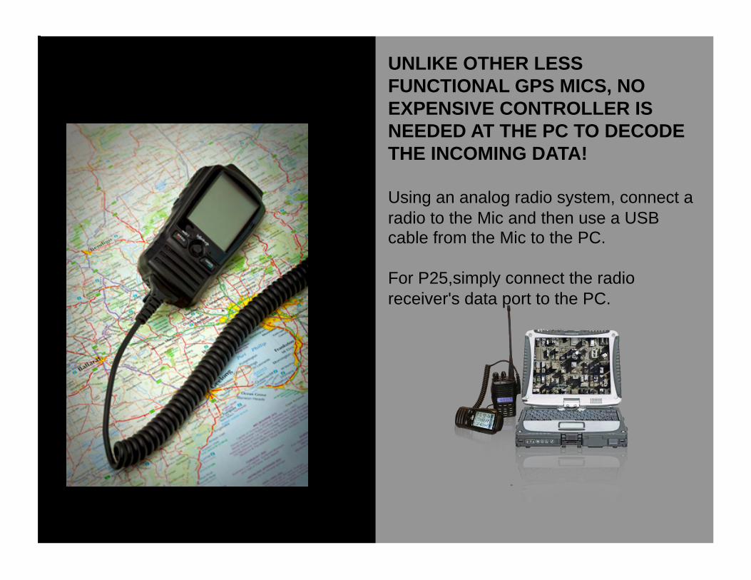
UNLIKE OTHER LESS FUNCTIONAL GPS MICS, NO EXPENSIVE CONTROLLER IS NEEDED AT THE PC TO DECODE THE INCOMING DATA!
Using an analog radio system, connect a radio to the Mic and then use a USB cable from the Mic to the PC.
For P25,simply connect the radio receiver's data port to the PC.

USER INTERFACE:
User may consult the various menus of the console using the built in joystick control.

USING THE JOYSTICK, ONE MAY SELECT: FINDER: View other User’s positions relative to the receiving party. See field unit’s speed, location, request a position update and navigate with an ETA to the position of selected group members.
TRACKS: The Mic console also works as a standard GPS Tracker. Stop tracks, start tracks automatically with Power Up of the console as well as by time / range. View track list details, delete tracks.
WAYPOINTS: Add, view, change name/symbol for, and navigate with ETA to waypoints; send to groups or individuals. Stores up to 50,000 waypoints.
FEATURE OVERVIEW

SATELLITE: Provides start up information ahead of a Mission: View GPS signal capture and constellations seen, VDOP accuracy status of GPS receiver, satellites & signal strength. See User’s location, elevation, speed, date, time,
COMPASS: Toggle between two compass views: (1) Due North (2) Floating. Use the Compass to set a course to a filed unit or a received or stored waypoint
UNIT STATUS: View speed, course, time, location, distance moved, average speed and convert DASTRUM used to ORG, UTM, or USNG..
FEATURE OVERVIEW

MESSAGES: Leverage your radio to send and receive confidential information and waypoints securely: Send & receive text messages to groups or individuals; view inbox by time/date received.
EXTRAS: Calendar displays dates from the year 2000 through year 2099
SETTINGS: Customizes and sets up the console: Configure the unit for analog or P25 digital operation; set format for Time, Date, Datum; Adjust LCD Contrast Distance/ Speed,/Elevation, Temperature units; Set User Name; Manage Power, Set SOS TX Time; and Data Baud Rate.
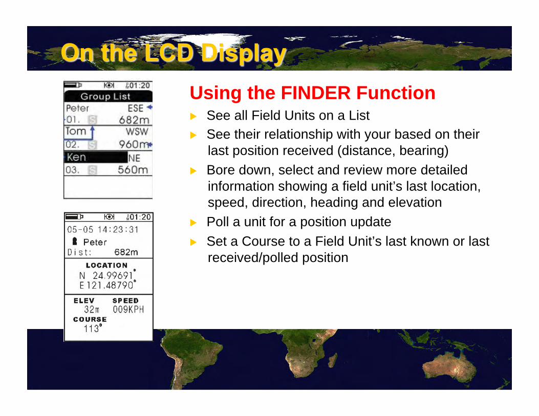
Using the FINDER Function ▶ See all Field Units on a List ▶ See their relationship with your based on their
last position received (distance, bearing)
▶ Bore down, select and review more detailed information showing a field unit’s last location, speed, direction, heading and elevation
▶ Poll a unit for a position update
▶ Set a Course to a Field Unit’s last known or last received/polled position

USING THE FINDER FUNCTION
Using the Joystick control: ▶ Poll a Field Unit for a positional
update
▶ See other Field Unit’s as how they relate to your position
▶ Set a Course to Field Unit
▶ Once you are moving, show your Estimated Time of Arrival (ETA) based on a straight line of travel

TEXT MESSAGING Function
Using the Mic's Virtual Keyboard and the built-in Joystick control, Send and Receive Text Messages
▶ Sends a message to an individual or group
▶ Messages may be 39 characters in length

Using the WAYPOINT Function
Maneuvering through the menus:
▶ Mark a Location as a Waypoint
▶ Name the Waypoint
▶ Attach a pre-set Icon to the Waypoint
▶ Store the Waypoint
▶ Send the waypoint to an individual or a group

Using the WAYPOINT Function
Maneuvering through the menus: ▶ Receive a Waypoint
▶ Store Waypoints in a Waypoint List
▶ Go To a Waypoint

Using the SATELLITE Function
Before embarking on a Mission provides the user with an easy way to validate operation of the unit:
▶ Information on number of satellites seen, signal strength
▶ 2D or 3 D Lock
▶ User’s position
▶ Accuracy of the system (PDOP)

In real-time all Group Members that are on the same radio channel may see all other members of their Group displayed on their unit’s LCD display without the use of a PC in reference to their own position along with relative distance and bearing, last known direction, speed and elevation.
TEAM MEMBER TO TEAM MEMBER

With a REDHAWK unit and 2 Way Radio: Team Member to Team Member
See other units, poll, send and receive text messages and waypoints. Set a course to a field unit or waypoint.
With a PC, Laptop, PDA or Tablet PC and a radio: Team Leader or Incident Commander to Field Team Members
See field units in real time on a Map, send and receive text messages and waypoints, poll a field unit
TOTAL SITUTATIONAL AWARENESS

TEAM MEMBER TO TEAM MEMBER
TEAMS IN THE FIELD VIEW ON THE LCD SCREEN

Connecting a Radio/GPS Mic to a PC/PDA/Laptop Using optional GIS software and a PC or like device an Incident Commander or a Team Leader can monitor all field unit movements in real time overlaid on a map or any GIS projection.
Command may poll field units receiving updated and the latest positional data, send, receive and view text messages and waypoints, etc..

SQUAD LEADER TO TEAM MEMBER
VIEW ON OPTIONAL GIS SOFTWARE for Laptop/PC/PDA
REDHAWK CORRESPONDING VIEW
on LCD Display

SQUAD LEADER TO TEAM MEMBER
Many off-the-shelf GIS software packages are available.
Complementary data string-sets are provided free of charge to software developers, GIS departments for
adaptation to existing and proprietary GIS/CAD systems
Following are just some of the software capabilities available.

SQUAD LEADER TO TEAM MEMBER
▶ Poll any radio/user to provide real-time update of resource locations
▶ Display all units in the field

SQUAD LEADER TO TEAM MEMBER
▶ Use the software’s map markup tools to designate and illustrate a search area, search area covered, annotate hazards
▶ Establish “no-go”, or “danger zone” using GIS fencing
▶ Alert Command if anyone that has entered a restricted area

SQUAD LEADER TO TEAM MEMBER
▶ Add satellite imagery providing a 3 dimensional view of the operation providing Command with a birds-eye view of the operation. Better identify hazards for field operatives.
Using Aircraft and a GPS Mic connected to a radio plot the perimeter of a fire, transmitting the data live to a PC or to users in the field.

SQUAD LEADER TO TEAM MEMBER
▶ Track teams live, in real-time. ▶ Playback complete stored tracks documenting the mission for after action review, training or audit. ▶ Create reports, map books, share information. ▶ Create a new layer for every operational period
SQUAD LEADER TO TEAM MEMBER
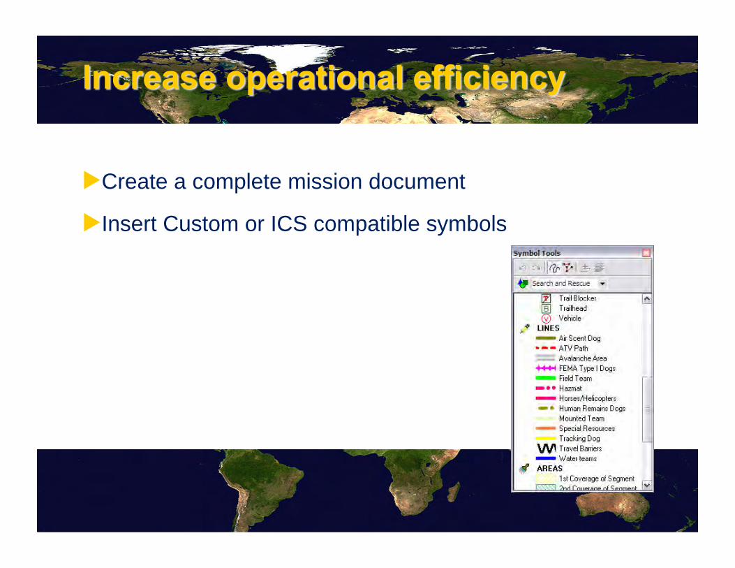
▶ Create a complete mission document
▶ Insert Custom or ICS compatible symbols

SQUAD LEADER TO TEAM MEMBER
▶ Send a waypoint for a mission to the field as selected on a GIS map using a stylus or touch screen
▶ Sending waypoints electronically avoids errors when compared to the use of traditional, verbal transmissions
▶ Sending text messages or waypoints electronically keeps information secure

SQUAD LEADER TO TEAM MEMBER
Some Case Studies and Applications:

SQUAD LEADER TO TEAM MEMBER
Hardware Validation: Y 2007: Rocky Mountain Colorado National Park Rangers have successfully tested the GPS Mic accessory connected to their model BK radios for a 4 month period validating feature, functionality, user friendliness, accuracy and durability. Results:
▶ Using the GPS Mic accessory augments situational awareness, Ranger safety.
▶ Creates tracks for download
▶ Communicates position to Dispatch
▶ Finds injured Rangers

SQUAD LEADER TO TEAM MEMBER
▶ In an Emergency: an SOS signal may be send out via a timed GPS position burst over the radio: even if the unit is out of contact with Dispatch.
▶ Approaching Rescuers with similar devices are then used to locate the Ranger.
▶ Conversely, anyone on the same radio channel with a like unit (or PC) may POLL and request any field unit to transmit an updated position.

SQUAD LEADER TO TEAM MEMBER
CASE STUDY 2: USE IN ACTUAL “DEAN CHRISTY” SEARCH,
SAN BERNADINO, CALIFOIRNIA, USA SHERIFF

SQUAD LEADER TO TEAM MEMBER
Search called off for hiker lost in San Bernardino Mountains
The Associated Press. Article Launched: 01/13/2008 05:52:27 PM PST
GREEN VALLEY LAKE, Calif.—The search for a hiker lost for over a week high in the snow-blanketed San Bernardino Mountains was called off Sunday, authorities said.
About 80 people combed the area near Green Valley Lake for Dean Christy for a final time but found no trace of him before the search was ended at 3 p.m., Sheriff's Sgt. Rick Ells said.
Christy, 62, made a cell phone call for help Jan. 4 when he became disoriented in fog at an elevation of about 7,000 feet. Sunday's search concentrated on a 1 kilometer area around where the phone call came from, Ells said.
"We've searched as well as we can," Ells said. "We've pretty much covered all the area we can." Rescuers were assisted by four snow cats, three helicopters and five search dogs. Although some snow has melted since the storm that caught Christy, movement in the rugged, densely wooded area has been made difficult by drifts as deep as 6 feet. Christy was wearing a down jacket, gloves and hiking boots, but had no food or water.

SQUAD LEADER TO TEAM MEMBER
▶ Individual field units may see in real time on their LCD screen progress and location of other teams.
▶ Users in the field may mark and name waypoints corresponding to potential evidence found and sending their details to other units without using voice.
▶ Send and Receive Text messages, and waypoints.

SQUAD LEADER TO TEAM MEMBER
▶ When connected to a PC and using GIS software, provides Incident Command with a 3 dimensional view and live updates of field units.
▶ On the GIS software, command may tap an area on the PC;s screen and send that waypoint to field users.

SQUAD LEADER TO TEAM MEMBER
“ CHRISTY SEARCH”, Tracks Days 1 to 5,
• Photo Courtesy: San Bernardino (CA., USA) Sheriff

SQUAD LEADER TO TEAM MEMBER
Case Study 3: Windsor, Colorado Tornado:
NWS Radar at 11:34 AM, May 22, 2008 Photo’s courtesy Rampart Search and Rescue R3.

SQUAD LEADER TO TEAM MEMBER
Within the First 10 Minutes
▶ Windsor proper, 18,670 inhabitants
▶ Affected people, property, livestock, infrastructure, and 5 communities, 600 homes damaged
▶ 1 death
▶ 1 x 38 mile wide path within 10 minutes

SQUAD LEADER TO TEAM MEMBER
Search & Rescue Teams Deployed
▶ During the first Operational Period of the first day, teams were deployed and were in night- time operations

SQUAD LEADER TO TEAM MEMBER
▶ Teams in the same operational period were given Missions and were inadvertently sent to the same area on multiple occasions, wasting time and valuable available human resources.
▶ Street signs were missing, out of town responders had difficulty in relaying accurate location information to ICS

SQUAD LEADER TO TEAM MEMBER
TEST OF TECHNOLOGY UNREHEARSED:
Second Operational Period : 2 way radios were equipped with the K&A Infinity Mic device.
5 Divisional Teams with Poudre Valley Fire & Rescue used the Mic Speaker Microphone over the next 3 operational days.

SQUAD LEADER TO TEAM MEMBER
▶ Result: ▶ Reduced Confusion at Incident Command.
▶ Full Time and Volunteer Responders were used more effectively.
▶ Waypoints were sent via the consoles with details as to damage assessment of individual buildings.
▶ Text messages reduced radio traffic and keeping confidential any sensitive discoveries.

SQUAD LEADER TO TEAM MEMBER

SQUAD LEADER TO TEAM MEMBER
With the GPS Mic Console:
▶ Individual Team Members could see areas covered by other Teams and Poll and update location of all Members without the use of verbal communications. ▶
Waypoint marking, naming of waypoints and their transmission aid in transmitting damage assessments to authorities.

SQUAD LEADER TO TEAM MEMBER
Case Study 4: Wildland Fires
▶ Providing real time updates to Incident Command and Field Units of Fire Perimeter and Progress.
▶ For Live Updates: A Helicopter was deployed to do a perimeter run of the fire where a GPS REDHAWK Console that was connected to a two way radio transmitted positional information once every 3 seconds. (Using the console’s SOS button)

SQUAD LEADER TO TEAM MEMBER
▶ As positional data was received from the helicopter:
▶ Field Units: ▶ See the perimeter of the fire on their Console’s
LCD Screen.
▶ See the Perimeter as it relates to their position in the field
▶ See Location and Tracks of all Fire Personnel on the same radio channel.

SQUAD LEADER TO TEAM MEMBER
▶ At Incident Command with a PC:
– See the perimeter of the fire overlaid onto GIS mapping.
– See the location and progress of all personnel in the field.
– Poll field units for updates
– Alert Incident Command of any units in a danger zone as created by a Geo-fence

SQUAD LEADER TO TEAM MEMBER

SQUAD LEADER TO TEAM MEMBER
Case Study 5: For Crowd Control and Safety
Formula 1 Grand Prix, SES, Melbourne, Australia Incident Command and Responders:
▶ See the Location and Progress of all personnel in the field.
▶ Manage better available Assets and Resources.
▶ Ensure that tasks and areas are covered
and missions are completed.

SQUAD LEADER TO TEAM MEMBER
Formula 1 Grand Prix, SES, Melbourne, Australia

SQUAD LEADER TO TEAM MEMBER
Other Applications: ▶ Motorcycle Police and Bicycle Patrols
▶ Campus Security
▶ Oil Field Production and Power Utility Workers
▶ Lumber and Resources Management ▶ Tactical and Specialized Police Units
▶ Lone Worker situations
▶ Resort Area, Parks, Recreation Area Management
▶ Ski Patrols
▶ …and more!
Get More Out of Your 2-Way Radio!

SQUAD LEADER TO TEAM MEMBER

Get More out of your radio!
Situational awareness is now in your hands!
RedHawk SA
Icom America Systems 2380 116th Ave NE Bellevue, WA, USA 98004
Voice: 425-450-6098 Fax: 425-450-6093 [email protected]
© 2011 Icom America Inc. Specifications, functions and features may be subject to change without notice