Embed Size (px)
Citation preview

Workshop Outline
1. Introduction – What is GIS?
2. What does GIS do and who uses it?
3. ArcGIS software discussion and
demonstration.
4. You use ArcGIS and make a map.
5. Questions and concerns.

What is GIS?
• Geographic Information System
• “a system for the management, analysis, and display of geographic information” (What is ArcGIS, ESRI Press, 2004)
• Mapmaking software • A way to visualize information

Google Earth – Sort of a GIS (Can add data; projection is imprecise)

DC Atlas – Almost a GIS. (Query, look at layers--but can’t add)

ESRI’s ArcGIS – the most popular GIS software. (Expensive)

What makes a GIS?
• Add and edit data • Make queries • Use various map projections for accuracy • Work with vector and raster data • Make map layouts • Read specific file types (shp, gdb, kml,
etc.) • Store data

Proprietary vs. Open Source
Proprietary
– ESRI ArcGIS – Cartographica (for
Mac)
Open Source/Free
– GRASS
– Quantum GIS
– DIVA-GIS
– GeoDa
– ArcExplorer

GIS (ESRI) on UMD Campus
• In McKeldin Library • on all public computers • [email protected]
• Other campus computer labs or terminals (access may be limited due to licensing)

GIS Courses at UMD
• Geography Department – GEOG 170, 306, 372, 373, 376, 472, 473, 475, 476
• Urban Studies – URSP 612
• Government & Politics (may be cross-listed) – GVPT 729
• Computer Science – CMSC 725
• Civil & Environmental Engineering – ENCE 200
• Criminology / Criminal Justice – CCJS 699
• Landscape Architecture – LARC 221, 341

Who Uses GIS?
• Municipalities and urban planners • Public health professionals • Federal government • First responders • Video game designers • Cartographers • Military • Etc., etc.

GIS for Urban Planning Riverside County, CA (from http://www.fhwa.dot.gov/tcsp/case7.html)

GIS for Politics 2004 election results by county, from USA Today

GIS for archaeology (Image from Geographical Information Systems in Archaeology / Conolly
and Lake)

GIS for environmental / natural resources / health

Why is GIS so great?
• Fast, powerful, interactive! – You can ask it questions—can’t do that with
paper maps. – Analysis and comparisons. – Easy layering. – Easy projection and changes of projection. – Land, water, space, time – works for all of
them.
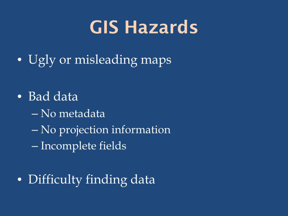
GIS Hazards
• Ugly or misleading maps • Bad data
– No metadata – No projection information – Incomplete fields
• Difficulty finding data

Working with a GIS
• Finding your data. • Cleaning up and assessing your data. • Querying and analyzing your data. • Making your data into useful maps.

ArcCatalog

ArcMap and ArcToolbox

GIS Data Vector - uses geometric
objects (points, lines and polygons) to represent real features on the earth’s surface such as light poles, roads and buildings. Ideal for discrete themes with definite boundaries.
Raster - is composed of a continuous grid of cells that represent a portion of the earth’s surface. Ideal for continuous themes where there is lots of change.
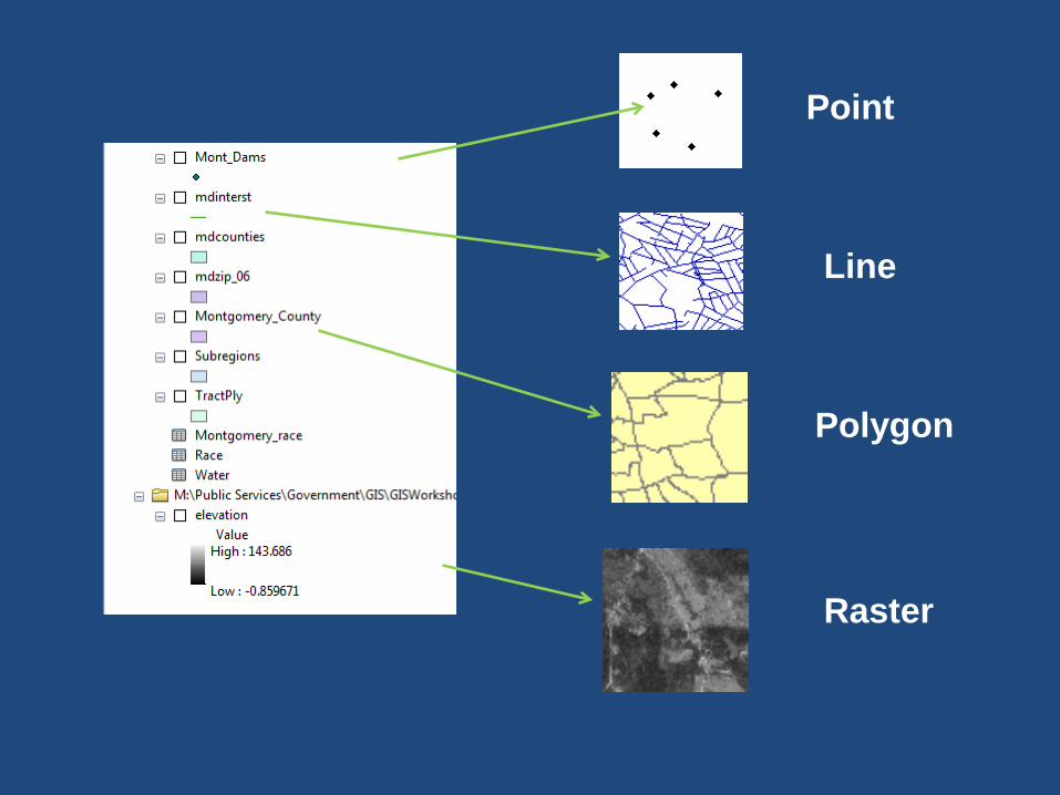
Point
Line
Polygon
Raster

GIS Data - Attribute Table

Let’s Go!
Demonstration of ArcGIS