Embed Size (px)
Citation preview

Paper G 27
GEOLOGIC HYPOTHESES ON LAKE TANGANYIKA REGION, ZAIRE, DRAWN FROM ERTS IMAGERY
Ulyera Wolyce and Senduve Ilunga, Bureau du President, Zaire
INTRODUCTION
Based on i n i t i a l work i n the Lake Tanganyika area o f eastern
Zaire, we conclude tha t ERTS imagery i s extremely useful f o r recon-
naissance leve l geologic mapping and analysis i n t h i s region o f the
humid tropics.
recognizing and mapping regional structural uni ts, f o r recognizing
major structural features, and f o r a r r i v i ng a t some preliminary
hypotheses about the mineral potent ia l o f the area. Results so f a r
indicate tha t ERTS imagery can make a major contr ibut ion t o the de-
velopment o f the mineral resources of our country. We hope t o continue
our research as pr inc ipa l invest igators i n the ERTS-B program.
I n par t icu lar , ERTS imagery has proven useful f o r
The Government of Zaire i s not a selected ERTS-1 pr inc ipa l
investigator. We learned o f the program too l a t e t o successfully
propose an experiment. However, recognizing the wide range o f potent ia l
applications that ERTS imagery could have i n the f i e l d o f resource
inventory, management and development i n our country, and ant ic ipat ing
the poss ib i l i t y o f par t ic ipat ing as Pr incipal Investigators i n the
ERTS-B program, the Government o f Zaire undertook an independent re-
search program on the applications o f ERTS imagery t o several resource
955
https://ntrs.nasa.gov/search.jsp?R=19740022659 2018-09-02T23:29:21+00:00Z
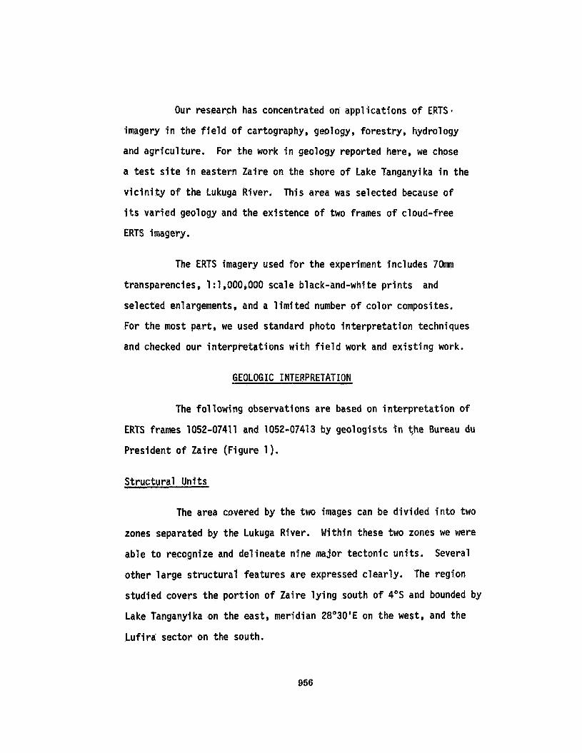
Our research has concentrated on applications o f ERTS
imagery i n the f i e l d o f cartography, geology, forestry, hydrology
and agriculture. For the work i n geology reported here, we chose
a t e s t s i t e i n eastern Zaire on the shore o f Lake Tanganyika i n the
v i c i n i t y o f the Lukuga River. This area was selected because o f
i t s varied geology and the existence o f two frames o f cloud-free
ERTS imagery.
The ERTS imagery used f o r the experiment includes 7Omm
transparencies, 1 :1,000,000 scale black-and-white p r i n t s and
selected enlargements, and a 1 i m i ted number o f co lor composites.
For the most part, we used standard photo in terpretat ion techniques
and checked our in terpretat ions wi th f i e l d work and ex is t ing work.
GEOLOGIC INTERPRETATION
The fol lowing observations are based on in terpretat ion o f
ERTS frames 1052-07411 and 1052-07413 by geologists i n the Bureau du
President o f Zaire (Figure 1).
Structural Units
The area covered by the two images can be divided i n t o two
zones separated by the Lukuga River. Within these two zones we were
able t o recognize and delineate nine major tectonic units. Several
other large s t ructura l features are expressed clear ly. The region
studied covers the por t ion o f Zaire l y i n g south o f 4"s and bounded by
Lake Tanganyika on the east, meridian 28O3O'E on the west, and the
Lu f i ra sector on the south.
956

7
6
1
D FOR FIGURE 1
U Te
Bea
/ 777 ’
7
Red Grits
Kwango Series
Lukuga and Walikale O r Niemba-Karoo Groups
Granitic Rocks
Katanga o r Shaba Supergroup, i ncl udi ng Kundel ungu and Roan
Ruzizi Group
Kibasa Group
Faults
Axis of Anticline
* Unfortunately, the overlay f o r Figure 1 was mailed separately and has been l o s t o r delayed i n t r ans i t .
957

958
Southern Zone. In this zone, lying essentially south'of 6 O S
and east of 28'E, one of the most prominent features i s a large anti-
cline or dome i n the eastern part of the region known as the Grand
Dome.
o u t on the dome and are flanked on the nor th by a narrow band of
lukugian and Wasakalien rocks which l i e along the south bank o f the
lukuga River. The area underlain by Lukugian rocks is actually divided
by the lukuga River, w i t h a strip of these rocks forming the north
valley wall of this river.
In this part of the zone, the Kibasa Group crops
The Grand Dome i s covered by the Kibasa Formation and sur-
rounded by the Rukugien through Niemba Formations and the Waljkien
Formation (Carboniferous through Upper Permian).
is known elsewhere as the Karoo. The Karoo i s equivalent t o the Gres
de Carnot which is well known as a diampnd-bearing formation in the
Central African Republic. This u n i t has yielded a few precious stones
i n the Equator Province of Zaire.
intrusions, the southern p a r t of the area is underlain by the Kundelunga
Group, the upper part of the well known Katanga Supergroup which contains
the rich copper deposits of Zaire i n i t s lower u n i t called Roan.
The base o f the Niemba
In addition to scattered granitic
Two large northeast trending faults cut the
southeastern part of the Grand Dome. One of these lies essentially on
the axis o f th i s breached anticline. The second, essentially parallel
to the f i r s t , passes through the Baudoinville area.
959

The rock u n i t exposed i n the southern crestal por t ion *o f
the an t i c l i ne i s c lea r l y different from the surrounding uni ts. This
i s the Kundelunga system.
The shores of Lake Tanganyika are composed of recent sedi-
ments derived from the upland described above. These sediments may
contain d e t r i t a l deposits o f minerals present i n the Dome.
Progressing t o the west, the western f lank o f the Dome i s
bordered by Kibasien rocks which under l ie the va l ley wal ls o f the
Niemba River. The region west o f the r i v e r i s essent ia l ly a grani to id
te r ra in characterized by a large number o f intrust ions.
Imnediately north and south o f the Lukuga River, banks o f
the r i v e r expose a l i t h o l o g i c u n i t which Cahan has ca l led Red Sandstone.
Northern Zone. This zone extends north o f the Lukuga and i s
dominated by the Muhomba Plateau, an extension o f the Mt. Mitumba upland
i n Maniema.
The un i t s cropping out i n the region are, i n order of
importance, the Ruzizi Group whose synclinal axes are occupied by the
Kwango and Lualaba series and over la in by the red sandstones and the
Ter t iary rocks. It i s i n these Rheatic age plunging synclines tha t the
coal beds were deposited. Three coal beds are the only mineral depos’its
current ly exploited i n t h i s region.
The area i s dominated by a large northwest trending f a u l t
system, which appears t o be traceable i n Tanzania across the lake. The
960
fracture system i s composed of a large number of individual fauits,
a l l essentially parallel. Another important faul t direction i s
suggested by a northeast trending faul t oblique t o the larger
northeast trending fault .
One interesting feature should be pointed out here. There
i s a white polygonal area visible in the highlands of the Northern
Zone.
shaped, l ight colored granite cut by numerous joints.
I t has not yet been identified, b u t i t may be a geometrically
As i n the Southern Zone, the Northern Zone has a large number
of granite intrusions.
Analysis o f Mineral Potential
1. The Karoo i s a continental deposit (Carboniferous,
Permian, Triassic and Jurassic). Rocks of these
ages are coal-bearing a l l over the world and are
diamond-bearing in the Central African Republic
(Gres de Carnot, for example) and i n the Equator Prov-
ince o f Zaire. T h i s u n i t also forms an extension
o f the "Golden Belt" of Kivu.
2. A1 teration halos surrounding granitic intrusions in
the area offer the possibility of supplemental
mineralizations such as uranium, beryllium, t i n ,
gold, zinc, lead, si lver, etc. Systematic study
961

of these in t rUSiOhS, particularly their a1 teration
ha1 os, may 1 ead to economic d i scoveries depending
on the degree of erosion.
3. The faulted areas north o f former Baudoinville should
be prospected, since they may have related copper and
possibly cobalt mineralization. Indeed, these faults
cut the underlying Roan copper belt formation.
general, the Katanga or Shaba Supergroup includes
three units:
In
- Kundelungu;
- Dolomitic schist, called Minier;
- Roan (Fai sceau des Mines).
Continental Basin
Because we are dealing w i t h a continental depositional s i te ,
i t m i g h t be well t o consider the type of deposits we are likely to
encounter. In general, a former continental basin i s also a former
river basin. Thus, there were waters running downhill and converging
i n the basin. The discovery of current direction indicators i n these
paleo-channels will indicate the direction t o the deepest part of the
basin.
There is a wide variety o f minerals associated w i t h conti-
nental basin deposition, including uranium, vanadium, copper, nickel,
etc. For example, the uranium associated w i t h vanadium of the Colorada
962

Plateau is found in a paleo-river basin, now a desert. Similarly, the
uranium in Agades, Niger occurs in a desert paleo-river basin.
fact, these beds are saturated with non-replenished fossil water which
defines the extent of the old basin. Copper as well as uranium can be
concentrated in the paleo-river channels and basins.
In
In assessing the mineral potential of continental sedimentary
terrains, one must consider both primary and secondary features, that
is , depositional and post-deposi tional possi bi 1 i ties such as secondary enrichment, alteration, etc. These two types of mineralization offer
the possibility of not only hydrocarbons and placer deposits such as
gold, but also gold, uranium, beryllium, wolframite, copper and zinc.
In light of these possibiltties, it i s particularly important
to consider structurally disturbed areas such as the Permian beds
present in the Hercynien folds o f the Kibasa region situation on the
edge of the African Shield peripheral to the Zaire 'basin. These are
deeply eroded folded chains that contain some volcanic rocks. These
are known to contain some deposits of magnetite, ilmenite, nickeliferous
minerals, gold in quartz, and tourmaline.
uranium and ilmenite result from erosion of the Karoo or Gres de Carnot.
Deposits of monazite,
For example, the grits of the thick Karoo in Africa are
diamond carriers. As mentioned above, in Central Africa Republic there
are diamonds in the Gres de Carnot, the lateral equivalent of the Karoo o f Zaire. A few stones have already been found in the Equator Province
of Zaire.
963

I n the fau l ted zones i n the region nor th o f Lake h e r o and
from Kapula t o Moba, Seremi has found ind icat ions o f wolframite,
t i n , copper, some graphi te schists, and ind icat ions o f gold.
Minera l izat ion Found i n the Southern and Northern Zones
The fo l lowing descr ip t ion o f prospecting tends t o v e r i f y
some o f the hypotheses based on the i n t e r p r e t a t i o n o f ERTS data.
Regional prospecting work was completed i n 1973.
No. 166 probably contains the fo l lowing deposits:
I n Kivu, block Zer
1. T in and wolfrarni t e on the Grand Dome are
considered certain.
2, T i n minerals, i lmen i te and tourmaline
e x i s t i n the metamorphic ser ies and i n
the black sands on the beaches o f Lake
Tanganyi ka.
3. Prospecting i n the zone o f a l te red Kibasien
evaporites around grani tes has y i e l ded
ind icat ions o f gold, t in , copper and other
associated minerals.
I n Shaba, block Zer No. 165 has even more promising possi-
b i l i t i e s w i t h about f i f t e e n anomalies o f copper/cobalt act ive, gold,
t i n , wolfram discovered i n Haute L u i z i and Kongolo, and the discovery
o f an extension o f the Katangian rocks i n the southeast p a r t o f the
block.
964

The Katanga Supergroup includes the Roan Formation which
contains the copper beds. Th i s i s a fortunate discovery and prospecting
is i n progress. Copper and zinc anomalies also were found i n Kikwanga,
Ngaza i n the Cretaceous rocks of Mwajhidi.
Other very recent discoveries include:
Augus t 1973 - Shaba, No. 165
1.
2.
3.
1.
2.
3.
Alluvial samples of gold, t i n and
wolfram i n Kongolo and Haute Luizi.
The discovery o f a deformed Katanga
granite outcropping over an area o f
approximately 1,000 km2 i n the south-
eastern part of Zer.
Granite and muscovite exposures i n the
K i bas fen.
- Kivu, No. 166
Cassiterite i n the Kawa River.
Syenite and grani te-bearing muscovite.
Quartz and tourmal ine , cassiteri te and
wol frami t e bordering the K i vu Permi an.
965
4. Various quartz veins containing
wolframite i n the northeast o f Zer.
These indicat ions seem t o be
promi s ing . September 1973 - Shaba, No. 165
Several s ign i f i can t samples i n terms of t h e i r
analysis suggest there may be as many as
f i f t e e n copperjcobalt anomalies.
- Kivu, No. 166
Several a l l u v i a l samples analyzed i n the course
o f a regional geologic study o f Kinshasa show
concentrations o f cass i ter i te .
CONCLUSION
Our preliminary test ing o f ERTS imagery f o r the purpose o f
assessing mineral resource potent ia l i n Zaire involved preliminary
del ineat ion o f tectonic un i ts and s t ructura l features on the imagery,
developing hypotheses about mineral potent ia l of the area based on what
we saw i n the imagery and general knowledge o f the geologic un i ts i n the
area, and preliminary test ing of these hypotheses using the most recent
information avai lable on resul ts o f mineral prospecting i n the area. To
date, we have used ERTS imagery covering only a small pa r t o f our country.
From t h i s work we conclude that ERTS imagery can probably make a material
966
contribution t o assessing the mineral resource potential of our country
and will be particularly valuable i n the less known areas. We very
much look forward to ERTS-B and an opportunity to t e s t ERTS imagery for
geologic exploration over larger areas.
ACKNOWLEDGEMENTS
We are deeply grateful to the Government of Zaire for its
support of this work, and particularly to M. Bisengimana Rwema, Director
of the Office of the President, We would like t o thank the people of
Earth Satell i te Corporation for their advice and assistance dur ing this
study, particularly Mr. Jack Palgen and Dr. John Everett, for translating
this report i n t o English and editing i t for publication.
967


![Engines and Carnot Cycle Markscheme - We Love …...1 Engines and Carnot Cycle Markscheme 1a. [1 mark] The P–V diagram of the Carnot cycle for a monatomic ideal gas is shown. State](https://img.pdfslide.us/doc/110x75/5fdebb59ad4070290d497d2d/engines-and-carnot-cycle-markscheme-we-love-1-engines-and-carnot-cycle-markscheme.jpg)