Embed Size (px)
Citation preview

Black Mountain Boulevard SR 51/Loop 101 Interchange to Cave Creek Road Environmental Assessment PHX-0(266)A Introduction and Purpose and Need Chapters 0000 MA PHX SS979 03D
1
Introduction
The purpose of this study is to evaluate alternatives for a north-south oriented major arterial street
located in the north Phoenix metropolitan area (Figure 1). The purpose of a future project, if
undertaken, would be to provide direct access to and from areas of existing and future development
and State Route (SR) 51, address a gap that exists in north-south oriented streets between Cave Creek
Road and Tatum Boulevard, increase efficiency of the transportation network by reducing congestion
and travel times for motorists, and provide greater regional mobility and improved access to other
subregions within the Phoenix metropolitan area.
Explanation of Environmental Assessment
This environmental assessment (EA) for Black Mountain Boulevard (BMB) between SR 51 and Cave
Creek Road was prepared in accordance with the National Environmental Policy Act of 1969 (NEPA) with
the Federal Highway Administration (FHWA) acting as the lead federal agency. The Arizona Department
of Transportation (ADOT) and the City of Phoenix (Phoenix) participated in conjunction with FHWA as
joint lead agencies in the planning, preparation, and review of all technical and environmental
documents. For the preparation of the EA, the United States (US) Bureau of Reclamation (Reclamation)
and the US Army Corps of Engineers (Corps) accepted FHWA’s invitation to be cooperating agencies.
Reclamation accepted the invitation due to potential impacts to their lands resulting from the range of
alternatives being considered for SR 51 to BMB ramp alignments, and to verify that the integrity of their
facilities would remain intact and continue to function adequately and efficiently as flood-control
facilities. The Corps accepted the invitation because of potential impacts to ephemeral washes that may
require Clean Water Act (CWA) Section 404 permitting.
According to Council on Environmental Quality (CEQ) regulations (40 Code of Federal Regulations [CFR]
§1508.9), the function of the EA is to describe the purpose and need for the proposed action,
alternatives for implementing or constructing the proposed action, and the environmental impacts of
the proposed action and alternatives; it also provides a listing of agencies and persons consulted. This
document serves as a tool for FHWA and ADOT to identify potentially significant impacts to social,
economic, and environmental resources along with measures that can mitigate these impacts.
Project Location
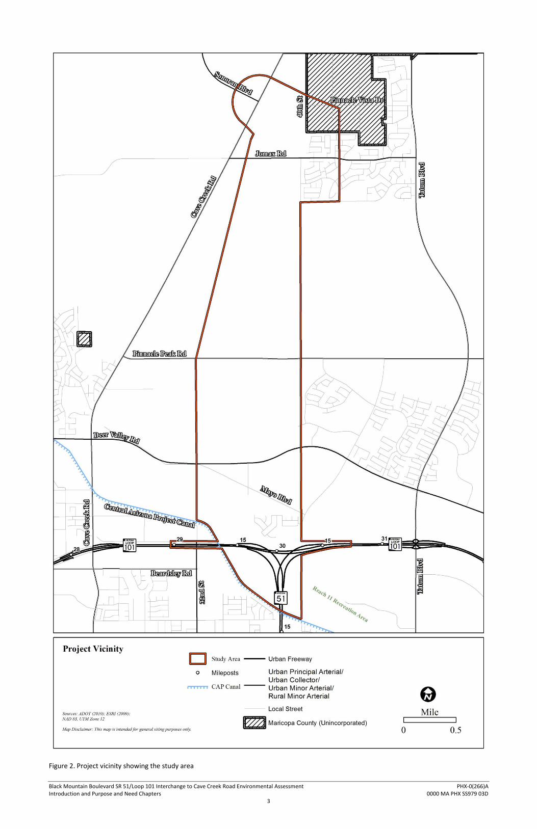
The study area is located in north Phoenix (refer to Figure 1) and is roughly bounded by the Central
Arizona Project (CAP) Canal to the south, the 32nd Street alignment to the west, the 40th Street
alignment to the east, and Pinnacle Vista Drive to the north (Figure 2). The study area is located entirely
within portions of the city of Phoenix and unincorporated portions of Maricopa County. Ownership of
the majority of the study area is split between State Trust lands managed by the Arizona State Land
Department (ASLD) and private holdings. The southern portion of the area paralleling the CAP Canal is
Federal land with the primary rights belonging to Reclamation. The portion of the study area between
Deer Valley and Pinnacle Peak roads also is Federal land managed by the Veterans Administration, which
operates the National Cemetery of Arizona (Figure 3).

Black Mountain Boulevard SR 51/Loop 101 Interchange to Cave Creek Road Environmental Assessment PHX-0(266)A Introduction and Purpose and Need Chapters 0000 MA PHX SS979 03D
2
Figure 1. State and county location map
Black Mountain Boulevard SR 51/Loop 101 Interchange to Cave Creek Road Environmental Assessment PHX-0(266)A Introduction and Purpose and Need Chapters 0000 MA PHX SS979 03D
3
Figure 2. Project vicinity showing the study area

Black Mountain Boulevard SR 51/Loop 101 Interchange to Cave Creek Road Environmental Assessment PHX-0(266)A Introduction and Purpose and Need Chapters 0000 MA PHX SS979 03D
4
Figure 3. Land ownership and jurisdiction

Black Mountain Boulevard SR 51/Loop 101 Interchange to Cave Creek Road Environmental Assessment PHX-0(266)A Introduction and Purpose and Need Chapters 0000 MA PHX SS979 03D
5
To adequately account for potential project impacts that may have consequences for the subregion
commonly known as north Phoenix or the Desert View Village, some aspects of the environment were
examined beyond the study area boundaries described above. Certain data, for example, population
projections and future traffic conditions, were studied for a larger area bounded by Bell Road to the
south, Cave Creek Road to the west, Tatum Boulevard to the east, and Dynamite Boulevard to the north.
This area encompasses approximately 8,000 acres or about 13 square miles. In this EA, project
construction area refers to the footprint of construction disturbance that would be created by the
implementation of the preferred alternative. Study area refers to the project construction limits and the
adjacent areas as depicted by the red-bordered shape in Figure 2. Project vicinity refers to the area
beyond the study area boundaries and may include the broader subregional context of north Phoenix.
Project Background and Overview
Phoenix was incorporated in 1881 and remained a small city until World War II and the following
economic boom (Phoenix 2012). The expansion beyond the original city limits to the north reached
unincorporated Sunny Slope by the 1950s and the CAP Canal alignment by 1990 (MAG 2008).
Throughout this time and into the present, Phoenix published general plans with regular updates to
specify the future land uses and zoning, as well as the transportation network to serve the expanding
city. The Maricopa Association of Governments (MAG), the entity responsible for regional transportation
planning, also contributes to the planning of transportation networks in Phoenix through the adoption
of the Regional Transportation Plan (RTP) that includes regional funding for arterial street projects (the
Arterial Life Cycle Program, or ALCP).
The component of the Phoenix General Plan that outlines the development of the City’s arterial street
network, known as the Street Classification Map, identified plans for BMB in 1994 (Phoenix 2010). BMB
was originally conceived as a north-south parkway connecting the future SR 51 with Cave Creek Road at
an intersection between the Jomax Road and Dynamite Boulevard alignments. BMB would connect with
east-west running arterial routes including Deer Valley, Pinnacle Peak, Happy Valley, and Jomax roads
forming a leg of the irregular but approximately one-mile spaced future arterial grid network. Updates
to the General Plan in 2002 better defined the BMB concept, abandoning the term “parkway” in favor of
boulevard to avoid public confusion caused by the historic use of the “parkway” to describe freeways.
Ultimately, BMB was adopted into the Street Classification map as a six-lane divided roadway (three
lanes in each direction) with a landscaped median (Phoenix 2010).
As documented in the Outer Loop Freeway Specific Plan (Phoenix 1995), BMB was integrated with the
planning efforts of the RTP and ramp connections between BMB and northbound and southbound SR 51
were incorporated into plans for the future system interchange connecting SR 51 and SR 101L. When
the SR 51/SR 101L System Interchange was constructed in 2003, the connection points were included to
provide for future ramps between SR 51 and BMB. When the new RTP was approved in 2004, the
construction of the ramps connecting SR 51 and BMB, including the segment of BMB from the ramps to
Deer Valley Road, was incorporated into the ALCP and became eligible for funding through regional
revenue sources. Along with regional revenue, the ramps and BMB segment terminating at Deer Valley
Road also is eligible to receive federal-aid funding. The remaining planned segment of BMB between
Black Mountain Boulevard SR 51/Loop 101 Interchange to Cave Creek Road Environmental Assessment PHX-0(266)A Introduction and Purpose and Need Chapters 0000 MA PHX SS979 03D
6
Deer Valley Road and Cave Creek Road is not part of the ALCP or currently eligible for regional funding
under the RTP, but would be eligible for federal-aid funding in the future. However, BMB segments
between Deer Valley and Cave Creek roads could also be funded by developers as adjacent lands are
developed.
Project Purpose and Need
The following summary illustrates the project purpose and need, which are discussed in greater detail in
subsequent sections of this chapter. The purpose and need provide a baseline for the development of
alternatives and are used as criteria to help evaluate and select a preferred project alternative.
Lands within the study area and vicinity have been developed or are committed to future development
and populations are projected to more than double over the next 20 years. Insufficient access to existing
and future development, and lack of mobility within these areas, is caused by gaps in the arterial street
grid. The gaps in the grid, especially the lack of a north-south oriented street between Cave Creek Road
and Tatum Boulevard, requires circuitous routes through bottlenecked access points for motorists to
reach SR 51. The inefficiencies in the transportation network for projected future conditions would
result in diminished quality of life and economic impacts from excessive trip times and traffic delays. The
lack of direct access to and from the study area and SR 51 would hamper motorists accessing other
subregions within the Phoenix metropolitan to the south and the associated employment and cultural
centers, shopping, education, recreation and entertainment facilities.
The purpose of a future project, if undertaken, would be to increase efficiency of the transportation
network, reduce congestion and travel times for motorists, provide direct access to and from SR 51 and
areas of future development, and provide greater regional mobility and improved access to other
subregions within the Phoenix metropolitan area.
Need for the Proposed Project
Population and Employment Growth
Phoenix experienced significant population increases in the twentieth century. By 1950, Phoenix had
106,000 residents and was ranked the 99th largest US city by population (Phoenix 2012). By 1990, the
population had grown to 987,220. The population reached 1,324,016 in 2000 and 1,451,966 by 2010
(Arizona Office of Employment and Population Statistics 2012). Phoenix is currently ranked the 5th
largest US city by population.
Population data specific to the study area and project vicinity was provided by MAG and is used as the
basis for their traffic models and projections of future travel demand. The Traffic Analysis Zones (TAZs)
are the smallest units for which MAG prepares projections and have boundaries that are defined using
major streets and landmarks (Figure 4). Existing population and estimates for 2035 were provided and
are summarized in Table 1.

Black Mountain Boulevard SR 51/Loop 101 Interchange to Cave Creek Road Environmental Assessment PHX-0(266)A Introduction and Purpose and Need Chapters 0000 MA PHX SS979 03D
7
Table 1. Current and Estimated Population of the Project Vicinity by TAZ
TAZ 2011 Population 2035 Estimated
Population Percent Change
511 41 4,573 11,054%
512 132 7,523 5,599%
514 2,760 4,480 62%
515 3,126 9,068 190%
562 260 7,536 2,799%
563 203 3,007 1,381%
564 411 990 141%
565 6,665 7,287 9%
567 5348 5,387 1%
569 823 10,417 1,166%
570 3,592 4,991 39%
572 5,172 9,912 92%
573 107 109 2%
TOTAL 28,640 75,280 163%
Note: Population values include resident population dwelling in households, populations dwelling in group quarters (dormitories, for example), transient population defined as those living in the project vicinity for two weeks or less, and seasonal population defined as those living in the project vicinity for between two weeks and six months. Source: MAG 2011

Black Mountain Boulevard SR 51/Loop 101 Interchange to Cave Creek Road Environmental Assessment PHX-0(266)A Introduction and Purpose and Need Chapters 0000 MA PHX SS979 03D
8
Figure 4. Project vicinity showing TAZs
Black Mountain Boulevard SR 51/Loop 101 Interchange to Cave Creek Road Environmental Assessment PHX-0(266)A Introduction and Purpose and Need Chapters 0000 MA PHX SS979 03D
9
Based on the projections presented in Table 1, the population for all of the TAZs of the study area and
vicinity are expected to increase. This is largely due to the availability of currently undeveloped land that
has been committed to residential development, as demonstrated in the Phoenix General Plan and ASLD
master plans such as Desert Ridge, Paradise Ridge, and Tatum East-West (Azara). These planned
developments, which are discussed in a subsequent section of this chapter, are zoned for between 2 and
10 dwelling units (homes) per acre.
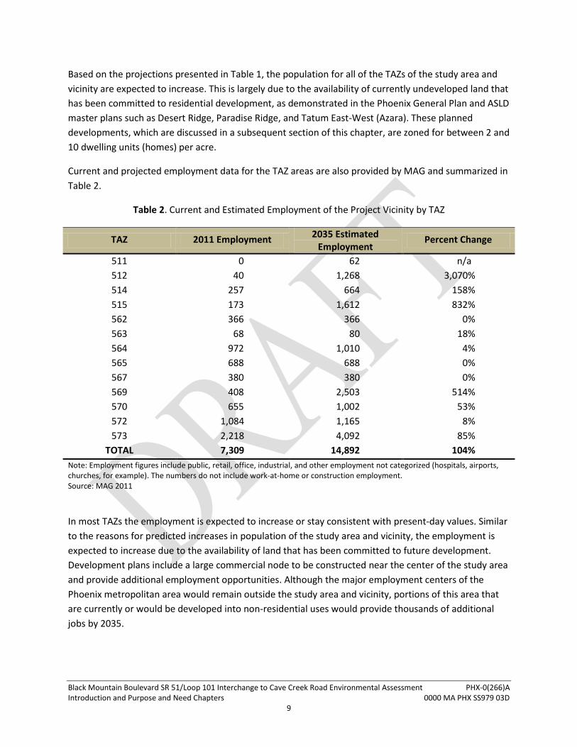
Current and projected employment data for the TAZ areas are also provided by MAG and summarized in
Table 2.
Table 2. Current and Estimated Employment of the Project Vicinity by TAZ
TAZ 2011 Employment 2035 Estimated
Employment Percent Change
511 0 62 n/a
512 40 1,268 3,070%
514 257 664 158%
515 173 1,612 832%
562 366 366 0%
563 68 80 18%
564 972 1,010 4%
565 688 688 0%
567 380 380 0%
569 408 2,503 514%
570 655 1,002 53%
572 1,084 1,165 8%
573 2,218 4,092 85%
TOTAL 7,309 14,892 104%
Note: Employment figures include public, retail, office, industrial, and other employment not categorized (hospitals, airports, churches, for example). The numbers do not include work-at-home or construction employment. Source: MAG 2011
In most TAZs the employment is expected to increase or stay consistent with present-day values. Similar
to the reasons for predicted increases in population of the study area and vicinity, the employment is
expected to increase due to the availability of land that has been committed to future development.
Development plans include a large commercial node to be constructed near the center of the study area
and provide additional employment opportunities. Although the major employment centers of the
Phoenix metropolitan area would remain outside the study area and vicinity, portions of this area that
are currently or would be developed into non-residential uses would provide thousands of additional
jobs by 2035.

Black Mountain Boulevard SR 51/Loop 101 Interchange to Cave Creek Road Environmental Assessment PHX-0(266)A Introduction and Purpose and Need Chapters 0000 MA PHX SS979 03D
10
Local Transportation Network and System Linkages
To accommodate the population and employment growth and the transportation needs of the
burgeoning population, Phoenix has generally developed an arterial street system that forms a grid of
major streets with one-mile spacing along section lines (Phoenix 2010). As the urban freeway system in
the Phoenix metropolitan area continues to be developed, the traffic interchanges (TIs, or the points of
access to and from the freeway) follow this general pattern of development, and TIs have been
constructed at the existing or planned major arterial streets with one-mile spacing.
Outside the urban core, the development and planning of the grid system has been impacted by
topography and geophysical obstacles requiring segments of the system to deviate from the grid
pattern. The lack of a contiguous arterial street network with consistent spacing impacts local access for
existing development and would continue to impede access as future development occurs. Without a
grid of major arterial streets, the future roadway network would resemble a dense and
incomprehensible system of secondary residential streets. No routes within a network lacking major
arterial streets would be capable of handling the traffic demands generated by the projected number of
residents in the study area and vicinity.
Irregularities in the arterial street network also influence the placement of TIs along freeways and can
create gaps in excess of one mile. These irregularities are evident in the study area and project vicinity.
For example, the lack of a continuous north-south arterial route between Cave Creek Road and Tatum
Boulevard; a gap tapering from approximately 3.5 miles in the south portion of the project area to 1.5
miles in the north portion of the project vicinity. This gap in the arterial street network at the south end
of the project area also corresponds to lack of freeway access for approximately 3.5 miles between
access points at Cave Creek Road and Tatum Boulevard. The gap in access points causes motorist to
funnel in and out of the project vicinity at a limited number of locations, and results in circuitous routes
and increased travel times. Motorists traveling to SR 51 from the study area are currently required to
travel on an east-west arterial to access Cave Creek Road or Tatum Boulevard, and then backtrack a
similar distance along SR 101L to access SR 51 through the SR 51/SR 101L System TI. Access to SR 51 is
important to the present and future residents of the study area and vicinity because SR 51 provides
direct access to the Phoenix metropolitan area to the south. Destinations include downtown Phoenix
and the associated employment and cultural centers, shopping, education, recreation and
entertainment facilities. SR 51 also connects the project vicinity to Sky Harbor International Airport and
provides connectivity to the Interstate Highway System at Interstate 10 (I-10).
Black Mountain Boulevard SR 51/Loop 101 Interchange to Cave Creek Road Environmental Assessment PHX-0(266)A Introduction and Purpose and Need Chapters 0000 MA PHX SS979 03D
11
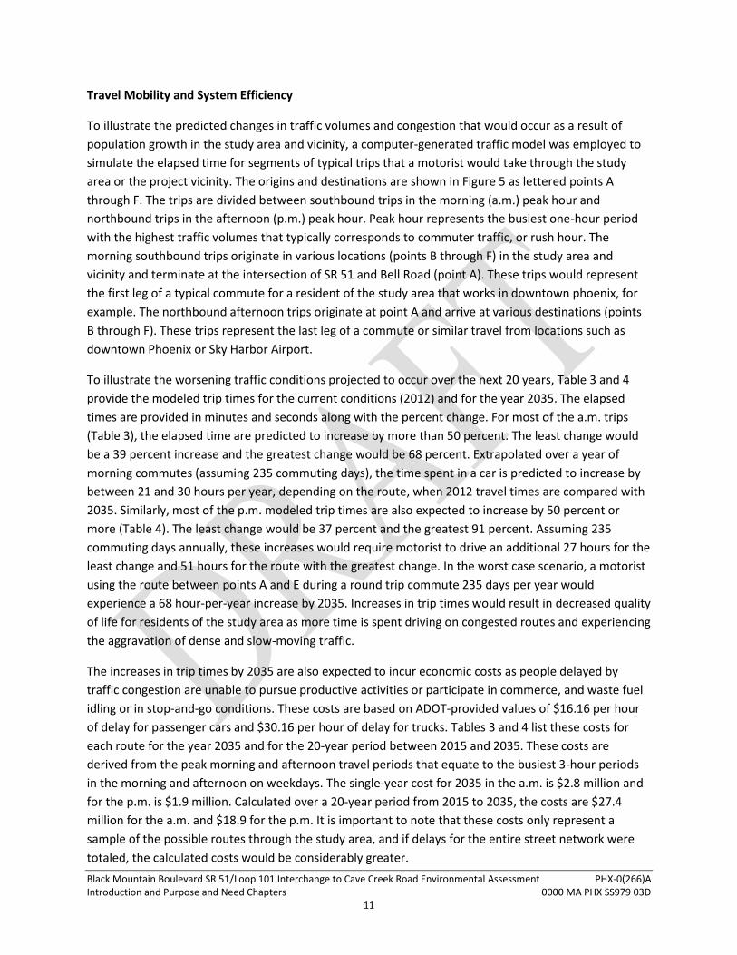
Travel Mobility and System Efficiency
To illustrate the predicted changes in traffic volumes and congestion that would occur as a result of
population growth in the study area and vicinity, a computer-generated traffic model was employed to
simulate the elapsed time for segments of typical trips that a motorist would take through the study
area or the project vicinity. The origins and destinations are shown in Figure 5 as lettered points A
through F. The trips are divided between southbound trips in the morning (a.m.) peak hour and
northbound trips in the afternoon (p.m.) peak hour. Peak hour represents the busiest one-hour period
with the highest traffic volumes that typically corresponds to commuter traffic, or rush hour. The
morning southbound trips originate in various locations (points B through F) in the study area and
vicinity and terminate at the intersection of SR 51 and Bell Road (point A). These trips would represent
the first leg of a typical commute for a resident of the study area that works in downtown phoenix, for
example. The northbound afternoon trips originate at point A and arrive at various destinations (points
B through F). These trips represent the last leg of a commute or similar travel from locations such as
downtown Phoenix or Sky Harbor Airport.
To illustrate the worsening traffic conditions projected to occur over the next 20 years, Table 3 and 4
provide the modeled trip times for the current conditions (2012) and for the year 2035. The elapsed
times are provided in minutes and seconds along with the percent change. For most of the a.m. trips
(Table 3), the elapsed time are predicted to increase by more than 50 percent. The least change would
be a 39 percent increase and the greatest change would be 68 percent. Extrapolated over a year of
morning commutes (assuming 235 commuting days), the time spent in a car is predicted to increase by
between 21 and 30 hours per year, depending on the route, when 2012 travel times are compared with
2035. Similarly, most of the p.m. modeled trip times are also expected to increase by 50 percent or
more (Table 4). The least change would be 37 percent and the greatest 91 percent. Assuming 235
commuting days annually, these increases would require motorist to drive an additional 27 hours for the
least change and 51 hours for the route with the greatest change. In the worst case scenario, a motorist
using the route between points A and E during a round trip commute 235 days per year would
experience a 68 hour-per-year increase by 2035. Increases in trip times would result in decreased quality
of life for residents of the study area as more time is spent driving on congested routes and experiencing
the aggravation of dense and slow-moving traffic.
The increases in trip times by 2035 are also expected to incur economic costs as people delayed by
traffic congestion are unable to pursue productive activities or participate in commerce, and waste fuel
idling or in stop-and-go conditions. These costs are based on ADOT-provided values of $16.16 per hour
of delay for passenger cars and $30.16 per hour of delay for trucks. Tables 3 and 4 list these costs for
each route for the year 2035 and for the 20-year period between 2015 and 2035. These costs are
derived from the peak morning and afternoon travel periods that equate to the busiest 3-hour periods
in the morning and afternoon on weekdays. The single-year cost for 2035 in the a.m. is $2.8 million and
for the p.m. is $1.9 million. Calculated over a 20-year period from 2015 to 2035, the costs are $27.4
million for the a.m. and $18.9 for the p.m. It is important to note that these costs only represent a
sample of the possible routes through the study area, and if delays for the entire street network were
totaled, the calculated costs would be considerably greater.
Black Mountain Boulevard SR 51/Loop 101 Interchange to Cave Creek Road Environmental Assessment PHX-0(266)A Introduction and Purpose and Need Chapters 0000 MA PHX SS979 03D
12
Figure 5. Travel routes
Table 3. Morning Peak Hour Travel Time Comparison for Southbound Traffic
Travel Route 2012 Travel
Time (minutes)
2035 Travel Time
(minutes)
Change (minutes)
Change (percentage)
Cost of Delay (2035)
Cost of Delay (2015 - 2035)
B → A (via Cave Creek Rd)
10:40 17:16 6:36 62% $534,000 $1,393,000
B → A (via Tatum Blvd)
9:16 15:36 6:20 68% $918,000 $4,364,000
C → A (via Cave Creek Rd)
11:13 18:52 7:39 68% $142,000 $1,548,000
C → A (via Tatum Blvd)
10:55 17:22 6:26 59% $446,000 $3,751,000
D → A (via Cave Creek Rd)
13:43 20:34 6:51 50% $158,000 $687,000
D → A (via Tatum Blvd)
12:28 17:20 4:52 39% $384,000 $1,414,000
E → A 12:23 19:36 7:13 58% $70,000 $5,218,000
F → A 10:18 15:16 4:58 48% $145,000 $8,977,000
Total $2,797,000 $27,352,000
Table 4. Afternoon Peak Hour Travel Time Comparison for Northbound Traffic
Travel Route 2012 Travel
Time (minutes)
2035 Travel Time
(minutes)
Change (minutes)
Change (percentage)
Cost of Delay (2035)
Cost of Delay (2015 - 2035)
A → B (via Cave Creek Rd)
14:27 27:34 13:07 91% $135,000 $1,324,000
A → B (via Tatum Blvd
9:16 14:19 5:03 54% $254,000 $2,486,000
A → C (via Cave Creek Rd)
15:30 26:59 11:30 74% $46,000 $446,000
A → C (via Tatum Blvd)
12:02 16:27 4:25 37% $159,000 $1,550,000
A → D (via Tatum Blvd)
17:29 31:27 13:58 80% $50,000 $488,000
A → D (via Tatum Blvd)
13:01 18:36 5:35 43% $115,000 $1,126,000
A → E 16:51 26:55 10:04 60% $317,000 $3,103,000
A → F 10:52 16:35 5:43 53% $853,000 $8,345,000
Total $1,929,000 $18,868,000

Black Mountain Boulevard SR 51/Loop 101 Interchange to Cave Creek Road Environmental Assessment PHX-0(266)A Introduction and Purpose and Need Chapters 0000 MA PHX SS979 03D
13
In the 2035, the projected congestion and inefficiency in the street network would also affect the travel
times for emergency services, especially between the study area and Paradise Valley Hospital located
near the intersection of SR 51 and Bell Road. Paradise Valley Hospital, south of the project limits,
operates the nearest emergency room to the study area. Similarly, the response time for law
enforcement also could be affected by the predicted congestion on the arterial street network in the
2035 scenario.
Conformity with Regulations, Land Use Plans, and Other Plans
This purpose and need was prepared in accordance with 40 CFR §1502.13, 23 CFR §450.212, the
FHWA/Federal Transit Administration’s (FTA) Interim Guidance on Purpose and Need, dated August 21,
2003, and the FHWA/FTA Safe, Accountable, Flexible, Efficient, Transportation Equity Act: A Legacy for
Users (SAFETEA-LU) Environmental Review Process Final Guidance, dated November 15, 2006.
A north-south arterial street between SR 51 and Cave Creek Road with ramp connections to SR 51 has
been adopted in the following transportation and land use plans. A composite of future land uses based
on these plans is shown in Figure 6.
General Plan: A Vision for the Future (City of Phoenix updated 2011)
Street Classification Map (City of Phoenix updated 2010)
Regional Transportation Plan Executive Summary (MAG updated 2010)
Desert Ridge Specific Plan: Master Plan and Development Regulations (ASLD and Northeast
Phoenix Partners 1990 as revised)
Desert Ridge, Paradise Ridge, and Tatum East-West (AZARA) Infrastructure Masterplan (ASLD
revised 2008)
Central Arizona Project Reach 11 Recreation Master Plan: Final Environmental Impact Statement
(Bureau of Reclamation 2002)
Outer Loop Freeway Specific Plan: Agua Fria and Pima Freeways (Loop 101) (Phoenix 1995)
The majority of lands in the study area are currently part of the State Land Trust managed by ASLD (refer
to Figure 3). The purpose of the State Trust is “to enhance value and optimize economical return for the
Trust beneficiaries, consistent with sound stewardship, conservation, and business management
principles supporting socioeconomic goals for citizens here today and generations to come” (ASLD
2012). On a continual basis, Trust land is sold to fund beneficiaries such as public schools and state
hospitals. These sales frequently occur in places where land is most valued and market demand is high,
as maximizing economic benefit for its beneficiaries is a goal of the Trust (ASLD 2012). The State Trust
land in the study area is one such location where land has high market value and demand is expected to
be high in conjunction with population growth. ASLD has planned accordingly for the anticipated future

Black Mountain Boulevard SR 51/Loop 101 Interchange to Cave Creek Road Environmental Assessment PHX-0(266)A Introduction and Purpose and Need Chapters 0000 MA PHX SS979 03D
14
Figure 6. Existing and future land use

Black Mountain Boulevard SR 51/Loop 101 Interchange to Cave Creek Road Environmental Assessment PHX-0(266)A Introduction and Purpose and Need Chapters 0000 MA PHX SS979 03D
15
demand for land in the study area and vicinity and is prepared to sell it for the maximum potential
economic benefit. The sale of the Trust land within the study area and vicinity and its planned
conversion to mostly private residential use is described in detail in the Desert Ridge Specific Plan:
Master Plan and Development Regulations and Desert Ridge and the Paradise Ridge, and Tatum East-
West (AZARA) Infrastructure Masterplan.
Conclusion
Land within the study area and vicinity is largely undeveloped but has been committed to future urban
development through the planning process by Phoenix and ASLD. These plans show the lands within the
study area are zoned for between 2 and 10 homes per acre with a large commercial node to be
constructed at the future location of BMB and Happy Valley Road. Population will increase as land is
subdivided and converted to residential uses, and employment within the study area and vicinity also is
expected to increase. The population is projected to grow in the study area from 28,640 to 75,280 with
employment increasing from 7,309 to 14,892. Corridors for arterial streets have been designated within
the study area and vicinity to provide access to and from the areas of planned development. These
arterial streets would serve to connect motorists with local destinations such as parks, schools, and
neighborhoods, and are intended to provide efficient access to and from the Regional Freeway System.
Without a comprehensive network of arterial streets, especially the lack of a north-south oriented street
between Cave Creek Road and Tatum Boulevard, motorists would be required to take circuitous routes
through bottlenecked access points to reach SR 51. The predicted trip times that motorists would
typically make to reach destinations south of the study area are expected to increase as traffic increases
on the arterial grid and access to SR 51 remains circuitous and inefficient. These travel times are
predicted to increase by 50 percent or more for most routes, with the worse case scenario adding 68
hours of additional travel time per year by 2035. These delays would also have an economic cost that for
the 20-year period between 2015 and 2035 is projected to be $46.3 million for 8 common routes
through the study area and vicinity. Lack of direct access to the Regional Freeway System would hamper
motorists accessing other subregions within the Phoenix metropolitan area and important destinations
such as downtown Phoenix and the associated employment and cultural centers, shopping, education,
recreation and entertainment facilities. The deficient transportation network would negatively affect the
implementation of land development plans and would decrease the quality of life and desirability of the
area for prospective future residents.
The completion of a north-south oriented major arterial street within the study area that provides direct
access to and from SR 51 would provide access to the areas of future development, increase efficiency
of the transportation network, reduce congestion and travel times for motorists, and provide greater
regional mobility with improved access to the Regional Freeway System.
Black Mountain Boulevard SR 51/Loop 101 Interchange to Cave Creek Road Environmental Assessment PHX-0(266)A Introduction and Purpose and Need Chapters 0000 MA PHX SS979 03D
16
References Cited
Arizona Office of Employment and Population Statistics. 2012. Census Data and Population Estimates.
http://azstats.gov/population-data-query-tool/. Accessed June 2012.
ASLD. 2012. ASLD website. http://www.land.state.az.us/index.html. Accessed June 2012.
MAG. 2003. List of Original ALCP Projects in the RTP.
http://www.azmag.gov/Documents/pdf/cms.resource/List_of_Original_ALCP_Projects_in_RTP1
1802.pdf. Accessed June 2012.
2008. Population Growth in Maricopa County 1912-2030.
http://www.azmag.gov/Documents/pdf/cms.resource/POPTAC_2008_Population-Growth-in-
Maricopa-County_1912-2030.pdf. Accessed June 2012.
2011. 2011 TAZ Data. Provided by MAG via Stanley Consultants Incorporated 2012.
Phoenix, City of. 1995. Outer Loop Freeway Specific Plan: Agua Fria and Pima Freeways (Loop 101).
2010. Street Classification Map. http://phoenix.gov/planning/stclass.pdf. Accessed June 2012.
2012. Out of the Ashes. http://phoenix.gov/citygovernment/facts/history/index.html. Accessed
June 2012.


![walk4life.info · Web viewLYONSHALL MEDIEVAL WALKS Walk No. 1. [Lyonshall Village Hall - circuitous route taking approximately one hour]. Start point: The Village “Memorial” Hall](https://img.pdfslide.us/doc/110x75/5e6525335a9331133070ecd5/web-view-lyonshall-medieval-walks-walk-no-1-lyonshall-village-hall-circuitous.jpg)