Embed Size (px)
Citation preview
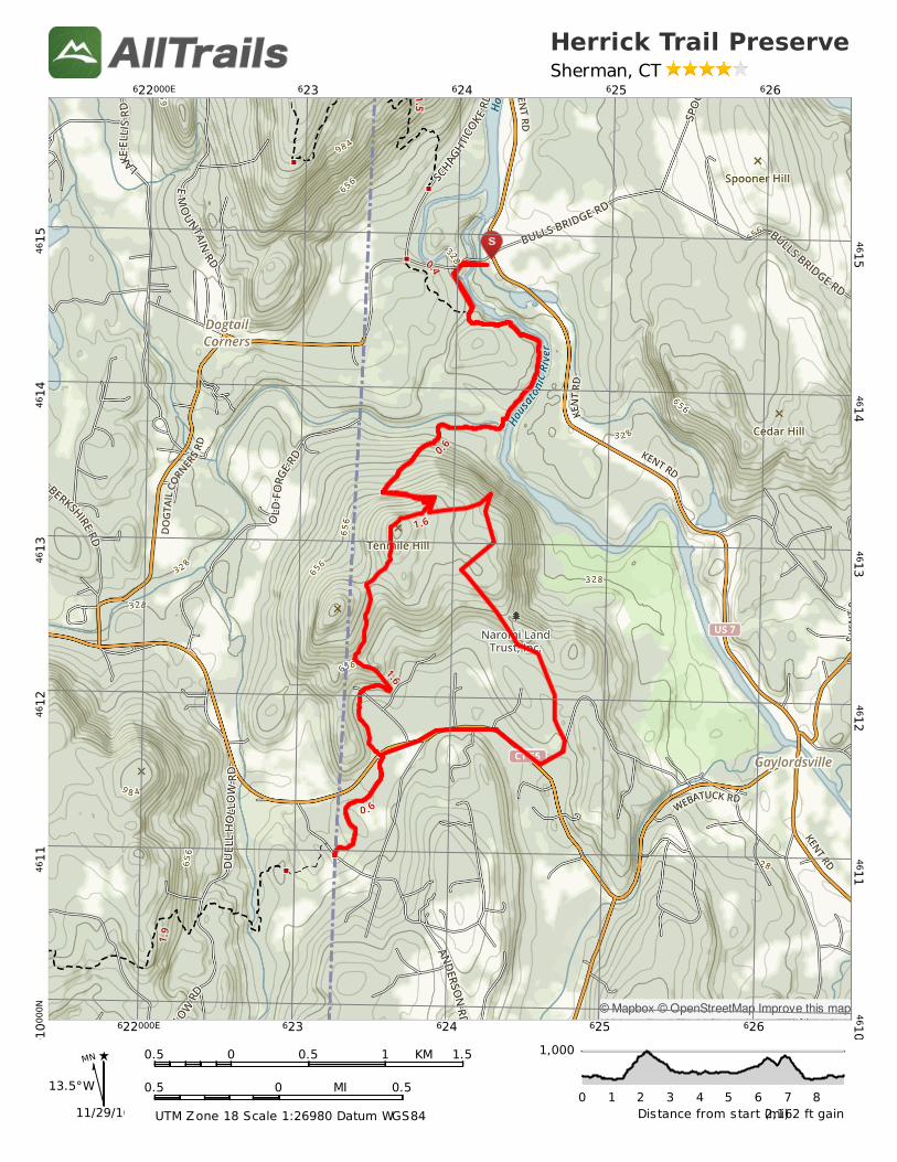
Introduction to UTM Coordinates UTM stands for Universal Transverse Mercator. Using UTM coordinates it is possible to easily identify a specific location on a map, with great precision. A UTM coordinate consists of three parts; a Grid Zone Designator, an Easting, and a Northing. The Grid Zone Designator is a number from 1-60 followed by a letter determined by the latitude within the numbered zone. The Easting and Northing are distances measured within the zone in meters. 18T,624187m E,4614799m N, Easting Northing
The key concept in learning to use UTM coordinates is to understand which digits identify a grid on your map, and which digits you need to measure within the grid square. Many of the maps gridded for these coordinate systems help the user by using a specific typographic style to represent the coordinates. 622 623 624 Notice that the distance between the grid lines (for example between 622 and 623) is one kilometer (one “click”), or 0.62 miles. So, UTM coordinates give you a sense of distance between two points on the map in a way that Lat/Lon coordinates do not! Again consider the following UTM coordinates: 18T,624187m E,4614799m N, Easting Northing
Now, look at the map below. Can you figure out what point on the map corresponds to these UTM coordinates? Is it the parking lot at Bulls Bridge, the point marked “S”? Suppose you are hiking in the area shown on the map, and you inadvertently stray from the trail. Further suppose that you see no features that would enable you to locate yourself on the map, just trees. You are momentarily lost. How do you know where you are so that you can navigate back to the trail and ultimately back to your intended destination? Well, if you have a GPS (or a smart phone with a GPS app such as HandyGPS or GPSTracks), you can use it to determine your current UTM coordinates, and these will tell you, with great precision, where you are on the map. Once you know where you are on the map, you are no longer lost. If you have GPS, a paper map with UTM coordinates printed in the margins, and a compass, you are “out of the woods”, so to speak.
MN
13.5°W
11/29/16
KM0.5 0 0.5 1 1.5
MI0.5 0 0.5
UTMZone18Scale1:26980DatumWGS84
1,000
Distancefromstart(mi)0 1 2 3 4 5 6 7 8
2,162ftgain
HerrickTrailPreserveSherman,CT
622000E 623 624 625 626
622000E 623 624 625 626
4610000N
4611
4612
4613
4614
4615
4610000N
46114612
46134614
4615
©Mapbox©OpenStreetMapImprovethismap