Embed Size (px)
Citation preview

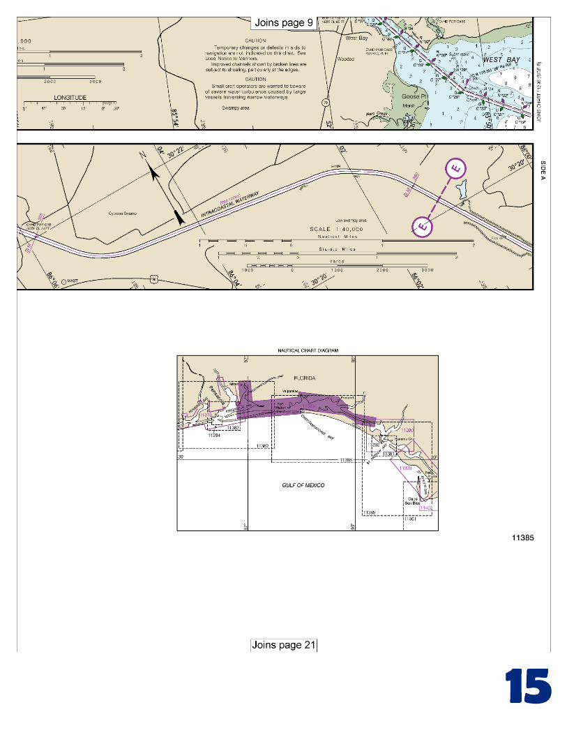
BookletChart™ Intracoastal Waterway – West Bay to Santa Rosa Sound NOAA Chart 11385
A reduced-scale NOAA nautical chart for small boaters When possible, use the full-size NOAA chart for navigation.

2
Published by the National Oceanic and Atmospheric Administration
National Ocean Service Office of Coast Survey
www.NauticalCharts.NOAA.gov 888-990-NOAA
What are Nautical Charts?
Nautical charts are a fundamental tool of marine navigation. They show water depths, obstructions, buoys, other aids to navigation, and much more. The information is shown in a way that promotes safe and efficient navigation. Chart carriage is mandatory on the commercial ships that carry America’s commerce. They are also used on every Navy and Coast Guard ship, fishing and passenger vessels, and are widely carried by recreational boaters.
What is a BookletChart?
This BookletChart is made to help recreational boaters locate themselves on the water. It has been reduced in scale for convenience, but otherwise contains all the information of the full-scale nautical chart. The bar scales have also been reduced, and are accurate when used to measure distances in this BookletChart. See the Note at the bottom of page 5 for the reduction in scale applied to this chart.
Whenever possible, use the official, full scale NOAA nautical chart for navigation. Nautical chart sales agents are listed on the Internet at http://www.NauticalCharts.NOAA.gov.
This BookletChart does NOT fulfill chart carriage requirements for regulated commercial vessels under Titles 33 and 44 of the Code of Federal Regulations.
Notice to Mariners Correction Status
This BookletChart has been updated for chart corrections published in the U.S. Coast Guard Local Notice to Mariners, the National Geospatial Intelligence Agency Weekly Notice to Mariners, and, where applicable, the Canadian Coast Guard Notice to Mariners. Additional chart corrections have been made by NOAA in advance of their publication in a Notice to Mariners. The last Notices to Mariners applied to this chart are listed in the Note at the bottom of page 7. Coast Pilot excerpts are not being corrected.
For latest Coast Pilot excerpt visit the Office of Coast Survey website at http://www.nauticalcharts.noaa.gov/nsd/searchbychart.php?chart=11385
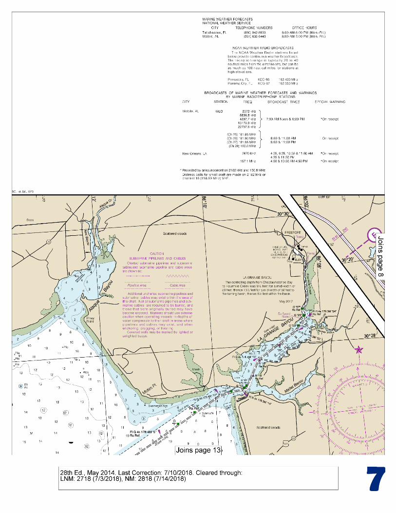
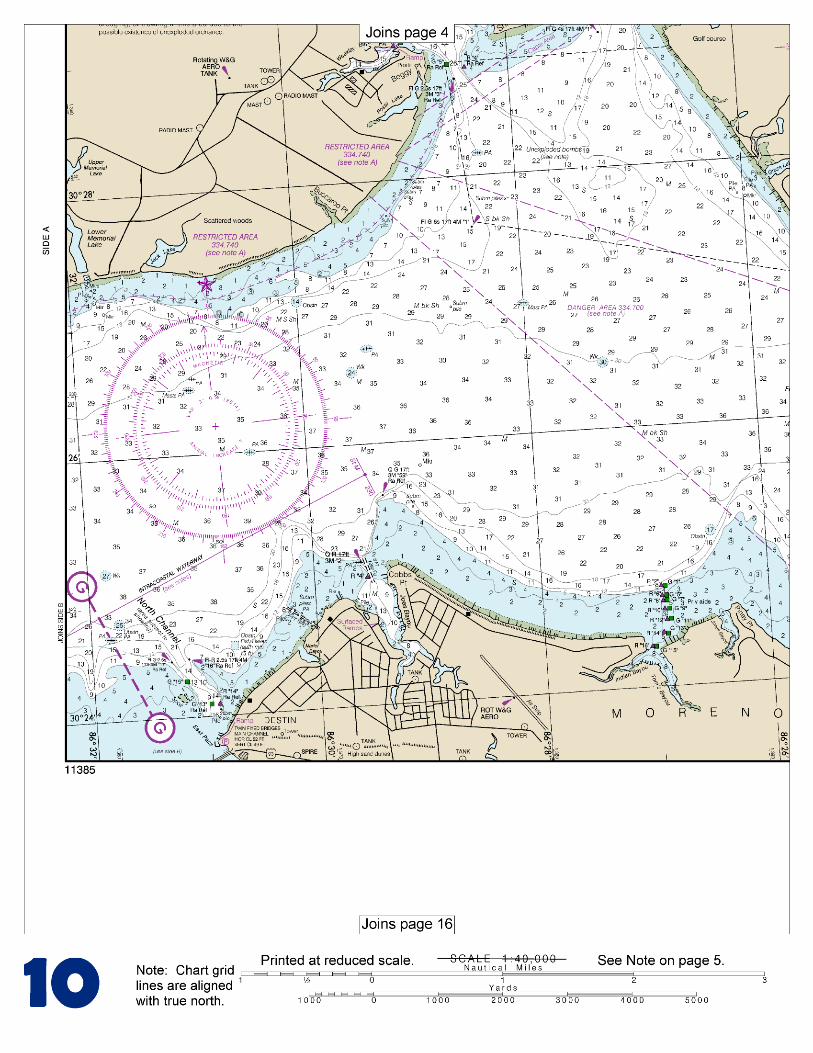
[Coast Pilot 5, Chapter 9 excerpts]. Choctawhatchee Bay Entrance. East Pass extends into the W part of Choctawhatchee Bay between Moreno Point and Santa Rosa Island, and is protected by two jetties. The jetties are marked by a light off their seaward ends. Choctawhatchee Bay Entrance Lighted Whistle Buoy CB (30°22'18"N., 86°30'24"W.), 0.5 mile off the entrance to the channel, marks the approach. To carry the best depths, mariners should be guided by the color of
the water. Passage should not be attempted in rough weather. Local knowledge is advised. The controlling depth was 5.5 feet (6.1 feet at
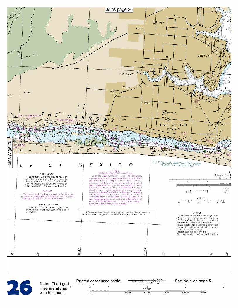
midchannel) from Buoy CB to the bridge; thence 9.9 feet through North Channel to the bay. The channel S of the bridge is subject to frequent changes and shoals between dredgings. Buoys are shifted to mark best water. The channel is marked by lights, buoys, and daybeacons. Choctawhatchee Bay. Depths in the bay decrease gradually from W to E with 18 to 43 feet in the W two-thirds, except near the shores, and 8 to 16 feet in the E third. Choctawhatchee River. The mouth of Choctawhatchee River is shallow, and boats enter through Cypress River. Cypress River entrance, marked by a light, has a depth of 6 feet. Black Creek, with depths of 8 feet inside, but bars of about 1-foot depth blocking the entrance, leads to the village of Black Creek. Berths, gasoline, a launching ramp, water, ice, and marine supplies are available at a small fish camp on the W bank of the creek 1.6 miles above its mouth. A channel leads from Choctawhatchee Bay to a turning basin at the head of navigation S of the fixed bridge at Freeport. The depth was 5½ feet (6 feet at midchannel) in the channel with 8½ to 9½ feet in the turning basin, except for lesser depths along the N and NW edges. The channel is well marked. The bridge at Freeport has a clearance of 5 feet. An overhead power cable with a clearance of 24 feet crosses the channel close E of the bridge. Access channels have been dug through the spoil banks to a channel along the E bank as far as Ramsey Branch. Depths of about 1½ feet were reported in these channels. A small marina on Ramsey Branch provides temporary bulkhead tie-up, limited marine supplies, and outboard engine repairs. There are private piers and fish piers on LaGrange Bayou and Fourmile Creek. Gasoline and marine supplies can be obtained on U.S. Route 331 and State Route 20 in Freeport. Basin Bayou. State Route 20 bridge across the narrow entrance with a clearance of 4 feet. A paved launching ramp is near the bridge and gasoline is available in cans. The launching ramp is accessible at high water only. Rocky Bayou has depths of 10 to 20 feet and affords good anchorage for small craft. The entrance to the bayou is marked on the W side by a light. A channel about 0.9 mile above the entrance to the bayou leads SE to a marina in Ward Cove. The channel is marked by a private buoy and had a depth of 6 feet. Gasoline, diesel fuel, berths with water and electricity, ice, a launching ramp, and marine supplies are available. A restricted area has been designated in Weekley Bayou, an arm of Boggy Bayou. (See 334.740, chapter 2, for limits and regulations.) The danger zones of two Air Force proving grounds have been established in Santa Rosa Sound, The Narrows, and the Gulf. (See 334.710 and 334.730, chapter 2, for limits and regulations.) Unexploded ordnance lies on the bottom a mile offshore from Santa Rosa Island, about 8 miles W of Choctawhatchee Bay Entrance. Santa Rosa Island and the E part of Perdido Key, W of the entrance to Pensacola Bay, are part of Gulf Islands National Seashore and subject to the rules and regulations of the U.S. Department of the Interior’s National Park Service.
U.S. Coast Guard Rescue Coordination Center 24 hour Regional Contact for Emergencies
RCC New Orleans Commander
8th CG District (504) 589-6225 New Orleans, LA

G
NOAA’s navigation managers serve as ambassadors to the maritime community. They help identify navigational challenges facing professional and recreational mariners, and provide NOAA resources and information for safe navigation. For additional information, please visit nauticalcharts.noaa.gov/service/navmanagers
To make suggestions or ask questions online, go to nauticalcharts.noaa.gov/inquiry. To report a chart discrepancy, please use ocsdata.ncd.noaa.gov/idrs/discrepancy.aspx.
Lateral System As Seen Entering From Seaward on navigable waters except Western Rivers
PORT SIDE
ODD NUMBERED AIDS
GREEN LIGHT ONLY
FLASHING (2)
PREFERRED CHANNEL
NO NUMBERS – MAY BE LETTERED
PREFERRED CHANNEL TO
STARBOARD
TOPMOST BAND GREEN
PREFERRED CHANNEL
NO NUMBERS – MAY BE LETTERED
PREFERRED CHANNEL
TO PORT
TOPMOST BAND RED
STARBOARD SIDE
EVEN NUMBERED AIDS
RED LIGHT ONLY
FLASHING (2)
FLASHING FLASHING
OCCULTING GREEN LIGHT ONLY RED LIGHT ONLY OCCULTING QUICK FLASHING QUICK FLASHING
ISO COMPOSITE GROUP FLASHING (2+1) COMPOSITE GROUP FLASHING (2+1) ISO
"1"
Fl G 6s
G "9"
Fl G 4s
GR "A"
Fl (2+1) G 6s
RG "B"
Fl (2+1) R 6s
"2"
Fl R 6s
8
R "8"
Fl R 4s
LIGHT
G
C "1"
LIGHTED BUOY
G
"5"
GR
"U"
GR
C "S"
RG
N "C"
RG
"G"
LIGHT
6
R
N "6"
LIGHTED BUOY
R
"2
"
CAN DAYBEACON
CAN NUN NUN
DAYBEACON
For more information on aids to navigation, including those on Western Rivers, please consult the latest USCG Light List for your area.
These volumes are available online at http://www.navcen.uscg.gov
Navigation Managers Area of Responsibility
Northeast
Lt. Meghan McGovern
Northwest and
Pacific Islands
Crescent Moegling
Great Lakes Region
Tom Loeper
Chesapeake and
Delaware Bay
Steve Soherr
California
Jeff Ferguson
[email protected] Mid-Atlantic
Lt. Ryan Wartick
Alaska
Lt. Timothy M. Smith
Western Gulf Coast
Alan Bunn
Central Gulf Coast
Tim Osborn
[email protected] South Florida
Puerto Rico
U.S. Virgin Islands
Michael Henderson
Southeast
Kyle Ward
2
2 C U 5
1


VHF Marine Radio channels for use on the waterways:Channel 6 – Inter-ship safety communications.Channel 9 – Communications between boats and ship-to-coast.Channel 13 – Navigation purposes at bridges, locks, and harbors.Channel 16 – Emergency, distress and safety calls to Coast Guard and others, and to initiate calls to other
vessels. Contact the other vessel, agree to another channel, and then switch.Channel 22A – Calls between the Coast Guard and the public. Severe weather warnings, hazards to navigation and safety warnings are broadcast here.Channels 68, 69, 71, 72 and 78A – Recreational boat channels.
Getting and Giving Help — Signal other boaters using visual distress signals (flares, orange flag, lights, arm signals); whistles; horns; and on your VHF radio. You are required by law to help boaters in trouble. Respond to distress signals, but do not endanger yourself.
EMERGENCY INFORMATION
Distress Call Procedures
• Make sure radio is on.• Select Channel 16.• Press/Hold the transmit button.• Clearly say: “MAYDAY, MAYDAY, MAYDAY.”• Also give: Vessel Name and/or Description;Position and/or Location; Nature of Emergency; Number of People on Board.• Release transmit button.• Wait for 10 seconds — If no responseRepeat MAYDAY call.
HAVE ALL PERSONS PUT ON LIFE JACKETS!
This Booklet chart has been designed for duplex printing (printed on front and back of one sheet). If a duplex option is not available on your printer, you may print each sheet and arrange them back-to-back to allow for the proper layout when viewing.
QR
Quick ReferencesNautical chart related products and information - http://www.nauticalcharts.noaa.gov
Interactive chart catalog - http://www.charts.noaa.gov/InteractiveCatalog/nrnc.shtmlReport a chart discrepancy - http://ocsdata.ncd.noaa.gov/idrs/discrepancy.aspx
Chart and chart related inquiries and comments - http://ocsdata.ncd.noaa.gov/idrs/inquiry.aspx?frompage=ContactUs
Chart updates (LNM and NM corrections) - http://www.nauticalcharts.noaa.gov/mcd/updates/LNM_NM.html
Coast Pilot online - http://www.nauticalcharts.noaa.gov/nsd/cpdownload.htm
Tides and Currents - http://tidesandcurrents.noaa.gov
Marine Forecasts - http://www.nws.noaa.gov/om/marine/home.htm
National Data Buoy Center - http://www.ndbc.noaa.gov/
NowCoast web portal for coastal conditions - http://www.nowcoast.noaa.gov/
National Weather Service - http://www.weather.gov/
National Hurrican Center - http://www.nhc.noaa.gov/
Pacific Tsunami Warning Center - http://ptwc.weather.gov/
Contact Us - http://www.nauticalcharts.noaa.gov/staff/contact.htm
NOAA’s Office of Coast Survey The Nation’s Chartmaker
For the latest news from Coast Survey, follow @NOAAcharts
NOAA Weather Radio All Hazards (NWR) is a nationwide network of radio stations broadcasting continuous weather information directly from the nearest National Weather Service office. NWR broadcasts official Weather Service warnings, watches, forecasts and other hazard information 24 hours a day, 7 days a week. http://www.nws.noaa.gov/nwr/