Embed Size (px)
Citation preview

INTERNATIONAL TROPICAL TIMBER ORGANIZATION (ITTO)
REDUCING DEFORESTATION AND FOREST DEGRADATION AND ENHANCING ENVIRONMENTAL SERVICES IN TROPICAL FORESTS (REDDES)
PROJECT DOCUMENT
TITLE
REDUCING EMISSIONS FROM DEFORESTATION AND FOREST DEGRADATION THROUGH COLLABORATIVE MANAGEMENT WITH LOCAL COMMUNITIES
SERIAL NUMBER
RED-PD 026/09 Rev.1 (F)
COMMITTEE
REFORESTATION AND FOREST MANAGEMENT
SUBMITTED BY
GOVERNMENT OF GHANA
ORIGINAL LANGUAGE
ENGLISH
SUMMARY The Ankasa Conservation Area, which incorporates the Nini-Suhien National Park and the Ankasa Resource Reserve, is considered as the most biologically diverse forest ecosystem in Ghana. However, due to encroachment by local communities for unsustainable shifting cultivation and illegal logging in and around the area, the conservation area is being over-exploited leading to deforestation and degradation. This leads to poverty-forest resource depletion cycle and decreased quality of environmental services including increased emission of greenhouse gases. Hence this project aims to contribute to sustainable management and conservation of Ankasa Conservation area to improve the provision of environmental services and reduce greenhouse gas (GHG) emissions. It specifically intends to develop and implement participatory, good governance and management system for the Ankasa conservation area, determine the financial value of the environmental services as well as methods for measurement, assessment reporting and verification (MARV) for forest carbon. The project will be participatory and thus will build on a high level community involvement and capacity building. EXECUTING AGENCY
FORESTRY RESEARCH INSTITUTE OF GHANA (FORIG)
COOPERATING GOVERNMENTS
-
DURATION
48 MONTHS
APPROXIMATE STARTING DATE
TO BE DETERMINED
BUDGET AND PROPOSED SOURCES OF FINANCE
Contribution Local Currency Source in US$ Equivalent
ITTO Gov’t of Ghana TOTAL
658,716
101,692
760,408

Table of Contents LIST OF ABBREVIATONS ___________________________________________ 2 1 PART 1: PROJECT CONTEXT ____________________________________ 3
1.1 ORIGIN ____________________________________________________________________ 3 1.2 RELEVANCE________________________________________________________________ 3
1.2.1 Conformity with ITTO’s objectives and priorities___________________________________ 3 1.2.2 Relevance to the submitting country’s policies ____________________________________ 5
1.3 Target area _________________________________________________________________ 7 1.3.1 Geographic Location ________________________________________________________ 7 1.3.2 Social, cultural, economic and environmental aspects ______________________________ 8
1.4 Expected outcomes at project completion ________________________________________ 12 2 PART 2: PROJECT RATIONALE AND OBJECTIVES __________________ 13
2.1 Rationale __________________________________________________________________ 13 2.1.1 Institutional set-up and organizational issues ____________________________________ 13 2.1.2 Stakeholder analysis _______________________________________________________ 15 2.1.3 Problem analysis__________________________________________________________ 15 2.1.4 Logical Framework Matrix ___________________________________________________ 19
2.2 OBJECTIVES ______________________________________________________________ 22 2.2.1 Development objective and impact indicators____________________________________ 22 2.2.2 Specific objective and outcome indicators ______________________________________ 22
3 PART 3: DESCRIPTION OF PROJECT INTERVENTIONS ______________ 23 3.1 OUTPUTS AND ACTIVITIES __________________________________________________ 23
3.1.1 Outputs _________________________________________________________________ 23 3.1.2 Activities ________________________________________________________________ 23
3.2 Implementation approaches and methods ________________________________________ 24 3.3 WORKPLAN _______________________________________________________________ 26 3.4 BUDGET __________________________________________________________________ 28
3.4.1 Master Budget Schedule____________________________________________________ 28 3.4.2 Consolidated budget by component (in U.S. Dollars)______________________________ 35 3.4.3 ITTO Budget by Component (in U.S. Dollars)____________________________________ 37 3.4.4 Executing Agency Budget by Component (in U.S. Dollars) _________________________ 38
3.5 ASSUMPTIONS, RISKS, SUSTAINABILITY ______________________________________ 40 3.5.1 Assumptions and risks _____________________________________________________ 40 3.5.2 Sustainability _____________________________________________________________ 40
4 PART 4: IMPLEMENTATION ARRANGEMENTS______________________ 41 4.1 Organization structure and stakeholder involvement mechanisms _____________________ 41
4.1.1 Executing agency and partners_______________________________________________ 41 4.1.2 Project management team __________________________________________________ 41 4.1.3 Project steering committee __________________________________________________ 42 4.1.4 Stakeholder Involvement and Mechanisms _____________________________________ 42
4.2 Reporting, review, monitoring and evaluation______________________________________ 42 4.3 Dissemination and on mainstreaming of project learning _____________________________ 43
4.3.1 Disseminating of project results ______________________________________________ 43 4.3.2 Mainstreaming of project learning_____________________________________________ 43
ANNEX 1. PROFILES OF THE EXECUTING AND COLLABORATING AGENCIES ___ 44 ANNEX 2. TASKS AND RESPONSIBILITIES OF KEY EXPERTS PROVIDED BY THE EXECUTING AGENCY ___________________________________________ 45 ANNEX 3: EXPERT COMMENTS AND THEIR RESPONSES _______________ 47

2
LIST OF ABBREVIATONS CREMA - Community Resource Management Area DSA - Daily Subsistence Allowance FSD - Forestry Service Division FAO - Food and Agricultural Organisation FCPF - Forest Carbon Partnership Facility FORUM - Forest Protection and Resource Use Management Project FSDP NRMP - Natural Resources Management Programme FPRI - Forest Products Research Institute GHG - Green House Gas GPRSP - Ghana Poverty Reduction Strategy Project HFZ - High Forest Zones IUCN - International Union of Conservation of Nature ITTO - International Tropical Timber Organization NTFPs - Non-Timber Forest Products PADP - Protected Area Development Programme PRA - Participatory Rural Appraisal REDD - Reduction of Emission from Deforestation and Degradation R-PP - REDD Readiness Preparation Proposal SFM - Sustainable Forest Management UNFCCC - United Nations Framework Convention on Climate Change

1 PART 1: PROJECT CONTEXT 1.1 ORIGIN This proposal originated from a study made on floral, fauna and habitat assessment of the CREMAs surrounding the Ankasa Conservation Area. During this study the local communities acknowledged that although the Park was of very much relevance they complained that they are not involved in the management of the area. They also complained that the park doesn’t helped them with their livelihood thus they undertake illegal activities to support their livelihood. It was agreed that there was some vegetation change which they thought was due to the change in the change in the weather patterns but were not aware of climate change During the debriefing session at the end the study, it was proposed that the research team was tasked to look how to get community involved in the management and also to improve their livelihood. Therefore, when the call for proposal on ITTO’s thematic programme on Reducing Deforestation and Forest Degradation and Enhancing Environmental Services in Tropical Forests (REDDES), was made, this proposal was developed and discussed with the local communities who gave their approval.
1.2 RELEVANCE 1.2.1 Conformity with ITTO’s objectives and priorities
The project contributes to REDDES programme by helping to address the REEDES core problem of inadequate capacity of ITO producer member countries and their stakeholders to maintain and enhance environmental services of tropical forests by preventing and reducing environmental degradation The proposal conforms to the general and specific objective of REEDES Thematic Programme which states as follows: The general objective of the Thematic Programme is to reduce deforestation and forest degradation enhance environmental services and help improve forest dependant livelihoods through sustainable management of tropical forests, forest restoration and other related activities. The specific objective of the Programme is to strengthen the capacity of ITTO developing member countries and their stakeholders to:
(a) reduce unplanned deforestation; (b) reduce forest degradation; (c) maintain and enhance climate change mitigation and other environmental services of tropical forests; (d) contribute to the social and economic sustainability and well-being of forest-dependent communities
by increasing forest values through forest restoration and rehabilitation, as well as payments for forest-based environmental services; and
(e) enhance adaptation and resilience of tropical forests to negative effects of climate change and human-induced impacts.
The following tables also demonstrate how the project contributes to the Tropical Timber Framework. Compliance with ITTA 1994 Objectives The project complies with the following objectives, as set forth in the International Tropical Timber Agreement (ITTA, 1994), Article 1: Definition How the project addresses the objective (c) To contribute to the process of sustainable
development. The project contributes to the sustainability of Ghanaian forests by managing restored degraded forest landscapes thus contributing positively to their productivity and biodiversity.
(f) To promote and support research and development with a view to improving forest management and efficiency of wood utilization as well as increasing the capacity to conserve and enhance other forest values in timber producing tropical forests.
The project has various research components, which aim at producing information for maximising productivity of restored degraded forest landscapes as well as improving livelihood methods for local communities.

4
The project is in harmony with the project activities: reforestation and forest management, of the organization as stated in Article 25.1 of the agreement. Further, it will contribute to the following functions of The Committee of Reforestation and Forest Management as stated in Article 27: Definition How the project addresses the objective (b) Encourage the increase of technical assistance and
transfer of technology in the fields of reforestation and forest management to developing countries.
The project has various research components where silviculturists, socio-economist and agroforester, and forest ecologists will provide input to the project beneficiaries.
(e) Facilitate the transfer of knowledge in the field of reforestation and forest management with the assistance of competent organizations.
The participating local organizations (FORIG, Wildlife Division and KNUST) have comprehensive experience in reforestation and forest management in Ghana. Their participation in the project will ensure that the knowledge is transferred to the community level.
As well as the following function of The Committee on Forest Industry: Definition How the project addresses the objective (a) Human resources development and training. The project has a strong component on human
resources development and training.
Additionally, the project will contribute to ITTO’s work in relation to statistics, studies and information as stated in Article 29 by generating new knowledge in relation to forest carbon stocks and tropical forest landuse changes Compliance with ITTO Yokohama Action Plan 2002-2006 The project will contribute to the following cross-cutting actions of the action plan:
The Project focuses on the Reforestation and Forest Management aspects of the ITTO Action Plan, including: Definition How the project addresses the objective GOAL 1, Action 1
Support the effective enforcement of forest laws and regulations that ensure sustainable forest management and secure the production base.
The project will work with the communities on forest governance as well as introduction of the most applicable incentive schemes.
GOAL 1, Action 2
Support networking and the exchange of information with relevant international organizations to maintain the integrity of the resource base, including protected area networks.
The project will utilise the expertise of international experts with substantial experience in the international climate change processes. There will be strong networking on progress made in reducing deforestation and forest degradation in developing countries.
GOAL 1, Action 4
Promote the conservation, rehabilitation and sustainable management of threatened forest ecosystems…
This project aims at achieving avoiding deforestation and forest degradation of the Conservation Area, and thus will contribute as a whole to sustainable management of threatened forests in Ghana.
GOAL 1, Action 5
Asses opportunities for, and promote development of, non-timber forest products and forest services which can improve the economic attractiveness of maintaining the forest resource base.
One of the major outputs of the project will be determination of potential carbon benefits from avoided deforestation which will improve the economic attractiveness of maintaining the forest resource base.
GOAL 1, Action 7
Identify shortcomings in enforcement of forest law and regulations, and overcome them.
The project will review and harmonise existing policy, legislative and institutional framework on community involvement in forest conservation and and benefit sharing arrangements
Definition How the project addresses the objective (a) Encourage and assist producing member countries to
identify and address constraints in their implementation of sustainable forest management and the sustainable development of the forest industry to enhance the contribution of the forest sector to national objectives.
The project aids Ghana to address challenges posed by integration of REDD into existing SFM activities. When this constraint is addressed, it will have a significant impact on the productive capacity of the Ghanaian forests and thus contributing to poverty alleviation, one of Ghana’s most important national objectives.
5
GOAL 2, Action 7
Contribute appropriately to national and international efforts in the area of prevention and management of fire in relation to tropical-timber producing forests.
Fire protection will be an integral aspect in the project implementation
GOAL 2, Action 10
Improve the productive capacity of natural forests, …, better utilization of lesser used-species, …, guided natural generation, …, and reforestation; Implement research and development activities in the management of secondary tropical forests, restoration of degraded tropical forests and rehabilitation of degraded forest land, taking into consideration ITTO guidelines; Undertake measures for the prevention and management of fire relating to tropical timber-producing countries; Intensify training of forestry personnel and other stakeholders in the management of both natural forests and timber plantations.
The project aims at generally on improving the productive capacity of Ghanaian forests, with a special emphasis on the communities. The project follows ITTO Guidelines on management of secondary tropical forests, restoration of degraded tropical forests and rehabilitation of degraded forest land as well as the ITTO/IUCN Manual on Forest Landscape Restoration Fire protection is an integral part of the project implementation. The training and capacity building are well considered in the project implementation.
1.2.2 Relevance to the submitting country’s policies This proposal is relevant to the National Forest and Wildlife Policy (1994) which has among it’s objectives as “to manage the existing forest estate for sustainability of timber and non-timber resources and to expand the nation’s forest cover for increased yields of domestic and industrial products, rehabilitation of denuded lands, protection of water catchments and stream banks and enhancement of the natural environment’’. It also relevant to Ghana’s Participation in the World Bank Forest Carbon Partnership for REDD. It is also relevant to Ghana’s effort to mitigate forest-related climate change challenges and Ghana’s National REDD strategy. The strategy among others recognizes the following:
the need to identify threatened forests to pilot REDD activities the need to design a credible monitoring and verification system for land use change related
emissions that reliable baseline and robust monitoring approaches are essential for advancing REDD
in Ghana the need to account for CO2 emissions and removals due to changes in carbon stocks on timely
basis that REDD for Ghana require capacity building along with demonstration activities, institutional
arrangements, benefit sharing arrangements, clarification of carbon rights etc. the use GIS for archiving and analyzing data coming from land-uses and carbon stocks that REDD would proactively support SFM, forest law enforcement and governance and ensure
forest protection Also Ghana’s REDD Readiness Preparation Proposal (R-PP) DRAFT v.1 26 has the goal and purpose as follows:
Goal: To achieve collective ownership of the process to develop strategies that reduce emissions through deforestation and degradation (REDD) and to support conservation, sustainable forest management, and the enhancement of forest carbon stocks (the + in REDD plus).
Purpose: To ensure that all stakeholder groups have a better understanding of REDD plus, how it relates to Ghana and what roles, responsibilities and opportunities they have within Ghana‘s efforts.
The following were the Summary of Discussions of Ghana’s Draft R-PP Fourth Meeting of the Participants Committee (PC4) on Forest Carbon Partnership Facility (FCPF October 27-28, 2009 — Washington, DC )
On Ownership across government agencies, sectors, and stakeholders: Participants noted that a key challenge in REDD is that of ownership across government agencies, sectors, and stakeholders (namely traditional owners and local communities), and asked for

6
clarification on who sits on the National REDD+ Steering Committee and how Ghana intends to address this challenge of ownership.
On Consultation and participation: Participants requested further detail on the planned consultation and participation process during R-PP formulation and Readiness Preparation. It was recommended that the REDD consultation process be strengthened along the lines of the process used under Ghana’s FLEGT Voluntary Partnership Agreement (VPA), which is considered by many to be an effective model.
On Addressing multi and cross-sectoral issues: Some participants suggested that the R-
PP should clarify the relationship between FLEG and REDD, and should focus more on carbon issues, the outputs of reducing deforestation and forest degradation, the contributions of REDD to the country’s social situation, and the role of other related areas (e.g., cocoa production, food and agriculture, conservation and sustainable forest management).
Thus to complement the Ghana FCPF, the following activities will be undertaken:
There will be start-up workshop where all the major stakeholders will be invited. The workshop will discuss the project objectives, outcomes output and activities. It will also determine the roles and responsibilities of each stakeholder group. Each stakeholder group will also have specific activities which they will implement and which they will report on at the quarterly Jomoro District Assembly meetings.
Participatory and verifiable methods for estimating forest carbon and monitoring will be implemented.
And capacity of community members will be built in assessment of emission reductions and forest carbon stocks.
The six monthly progress report will also be widely circulated to all stakeholders including Government Agencies ,Local Communities, Traditional Rulers, FCPF secretariat, FAO, District Assembly staff etc
Biyearly meetings will be held to discuss the progress report and how activities will be improved on, if the need be. The FCPF Secretariat as well as the Ministry of Lands and Natural Resources will be invited to these meetings. Data on carbon stocks will be shared with all relevant stakeholders.
In addition the proposal is relevant to the Ghana Poverty Reduction Strategy Programme (GPSRSP). The GPSRSP document emphasizes the need to:
Protect, rehabilitate and sustainably manage the national land, forest and wildlife resources through collaborative management and aimed at increasing the incomes of rural communities who own these resources.
Enhanced community involvement in the management of forest and wildlife and savannah woodland resources and improve the benefit flows to communities from resource sales.
This proposal is consistent with ITTO objectives
(a) To promote the expansion and diversification of international trade in tropical timber from sustainably managed and legally harvested forests
(b) To promote the sustainable management of timber producing forests because the proposal aims at sustainable management of the Ankasa Conservation area, develop management plans for the area which will determine where and when to harvest timber trees and promote the prevention illegal logging.
Furthermore the proposal is related to these ITTO activities in Ghana:
PD 30/97 Rev (6) F: Rehabilitation of degraded forests with collaboration of local communities. The species which had maximum growth, the lessons learnt and the capacity building aspect of this project will facilitate the implementation of this project. Also important is the lessons learnt on soliciting community support to achieving effective collaboration and as well community-ownership of such projects.
PD 284/04 Rev.2 (F): Fire Management and post-fire restoration with Collaboration of Local Communities in Ghana. Although fire is vey rare in the Ankasa areas, the manual on the

7
community based fire management will be made available so as to prevent any fire in the area.
PD 105/01 Rev.3 (F): Alternative mixed plantation systems and restoration strategies for conservation and sustainable production of timber species in Ghana. The lessons learnt will facilitate successful establishment of ecologically stable plantation systems with native species that are less vulnerable to incidence of pests and disease in the Ankasa area.
PD 105/01 Rev.3 (F): Towards Sustainable Timber Production in Ghana: Stage I. Improving Shoot Borer Resistance and Developing Silvicultural Systems to Maximize Mahogany Plantation Success. Results of this project, especially related to improved silviculture and pest control, will help promote the development of plantation-grown African Mahogany in the study area.
PD 431/06 Rev.1 (I): Processing and utilization of trees on farmlands and logging residues through collaboration with local communities. This project will learning from this project facilitate in the processing of trees on farmlands. This project offers valuable lessons on how to reduce/prevent illegal logging in the Ankasa area. The outputs are also important in the valuation of the ecosystem services as well are the development of the benefit sharing scheme for REDD in Ghana
PD 424/06 Rev.2 (F): Conservation and utilization of medicinal plants in Ghanaian forest fringe communities. Lessons in this project will help in developing conservation and sustainable utilization strategies for medicinal plant species within forest the areas.
1.3 Target area The principal target beneficiary would be the local communities within and around the conservation area, the management of the Ankasa Conservation Area, the Wildlife Division of the Forestry Commission, the Government of Ghana and the Forestry Commission. It will help in participatory management of conservation thus ensuring the protection of the biodiversity improve their livelihood and also contribute to reducing Ghana’s greenhouse gas emissions. The technologies and capacity built will enhance Ghana’s capacity in national greenhouse gas accounting and thus strengthen her commitment to the international climate agenda. Globally, the project will contribute to enhancement of environmental services such, carbon sequestration and biodiversity conservation. 1.3.1 Geographic Location The Ankasa Conversation Area is an area the Jomoro District in southwestern Ghana (Figure 1), about 365 kilometers west of Accra near the border with Côte d'Ivoire. It incorporates the Nini-Suhien National Park and the Ankasa Resource Reserve. The park is approximately 500 square kilometers, and consists largely of tropical evergreen rainforest. The Ankasa, Nini, and Suhien Rivers all pass through the park, and are known for their rapids and waterfalls. The forest has the most biological diversity of any in Ghana, with over 300 different plant species having been recorded in a single hectare of forest. Animal life includes the elephant, bongo, chimpanzee, Diana monkey, and 263 species of birds. It is located on Latitude 5o17' N and Longitude 2o35' W. Being tropical, the district is hot and humid. August is the coldest month and March the hottest. Relative humidity in the night is about 90% descending to 75% in the afternoon. The driest period is December and January. The area experiences two rainy seasons from April to July and September to November. There is a short dry spell in August and longer dry period in December to January. Although February and March are relatively hot, a number of rains usually allow cropping to begin. The study area is the wettest part of the country with average annual rainfall more than 1732mm.

8
Figure 1: Map of Ghana showing location of the Ankasa Conservation Area 1.3.2 Social, cultural, economic and environmental aspects 1.3.2.1 Social aspects
The population of the district is about 111,348 with a density of 83 persons per km2 and an annual growth rate of 3%. (2000 Population and Housing Census). The demographic structure of the Jomoro District has some common features with other rural districts in Ghana such as low density, high mortality rates and relatively high out migration. However, there are some specific characteristics due to the low development level of the district. The population of the district fell from 45, 162 in 1960 to 37,685 in 1970. It sharply rose to 70,881 in 1984 and that of the year 2000 was 111,348. The population density of 83 persons per square kilometer in 2000 portrays a rural district where population is not yet a problem. The male population of the district constitutes 49.7% while the female takes 50.3%. This shows a deviation from the Regional figure that indicates higher percentage for males than females. The population of the district is 5.8% of that of the region. The dependency ratio is approximately 1:1. The male population of Jomoro constitutes 49.7% while that of female takes 50.3%. The 0-14 cohorts constitute 67 percent of the total population while the aged 65 years and above make only 2 percent. The dependant population in the district, that is those in cohorts 0-14 years plus those in cohorts 65 years and above constitutes 69% of the total population. The economically active population (i.e. 15-64 years cohort) constitutes 31 % of the total population. The dependency ratio in the district, that is the ratio of the elderly (those aged 65 years and above) plus the youth (those under 15 years) to the population in the “working age” (those in cohorts 15-64 years of age) is 0.278:1. This in demographic

9
sense means that, every 100 economically active persons have 278 extra persons to cater for. Simply stated, the ratio is 1:3. In the area like most parts of Ghana, there are more male-headed households than female-headed households; males are seldom recorded as spouses. On the other hand, females are recorded more as spouses than as heads of household. This may be due to delay in marriage or young adult females with children living independently. Indeed, the fact that there is not a one-to-one correspondence between male heads and female spouses and between female heads and male spouses means that many heads of households may be single parent or single person households. This appears more the case for female heads than it is for male heads. The cultural phenomenon of normally deferring to the male in a sort of patriarchal relationship even if that male is himself dependent on the female of the household, cannot also be discounted in accounting for the high percentage of male heads of household. Marriage in the area includes formal unions by ordinance, traditional or religious rites and informal co-habiting unions. More than half of the marriageable population (15 years and older) in the district are living together either on formal or informal basis. The societal expectation that a man should be able to provide economic support for his family even in the face of economic hardship tends to delay marriage in the area. In this area there are more males than females who have never been married. In contrast, larger proportions of females than males are married. This may be because men, who normally have to bear the cost of getting married, have to ensure that they are adequately prepared before marriage. In Ghana, there is religious pluralism, in which a wide variety of religious preferences exist side by side. Christianity is the largest religion in all the districts. In the area, within the Christian religion, Catholics predominate with over a population of 32.8%. Literacy is an important indicator of social development and such high levels of illiteracy across the districts indicate under-development in most parts of the region. The area have less than 20 per cent of persons above 15 years literate in the English language only, while it has between 1.3 and 2.9 per cent of persons literate in only a Ghanaian language. Literacy in English and a Ghanaian language is however widespread. More than one-quarter of all persons above 15 years throughout the districts are literate in both languages. At the primary and junior secondary level, there is not much difference in educational attainment of males and females. At the primary level, females seem to outnumber males in most districts. The trend however begins to change as one climbs up the educational ladder to the tertiary level. The area has high proportions of both males and females with senior secondary education. In this case this could be explained by the presence of large numbers of customs and security personnel at the borders, all of whom are expected to have at least a senior secondary school certificate before they can be recruited into these services. Every community in the district has a chief and his elders which is hereditary. They also have elected Assembly men and Unit Committee members who represent them at the District Assembly at Half Assini which is District Headquarters. As has been stated earlier, the Western Region, especially the Jomoro District is potentially one of the richest regions of the country. Yet in terms of infrastructure and educational facilities, the area faces many difficulties. To ensure the full participation of local communities in the implementation of the project strategy, activities presented in this section are meant to foster their involvement in terms of participatory reflection and action. Project awareness campaigns and start-up workshops: Lack of communication between project planners, implementation agencies and communities ranks high as a major cause of failures in many projects. Policies and plans designed must always be clearly understood by community members and representatives so that they can be responsive to project needs and desires. To ensure sustainability of management strategies identified and implemented under the project, community-focussed management would be the foundation upon which the project team’s approach in dealing with the communities in the project area would be built. The development of a high level of community involvement and organisation will be an overall objective that will be taken into consideration at all stages of the project cycle. Consequently, the first major activity in each community within the project area will be a start-up workshop organised in collaboration with the respective district assemblies to bring together all the stakeholders in the project within the communities. The project team will make initial visits to each community within the project area well before the start-up (introductory) workshop to meet personnel of the district assemblies and communities, introduce the project
10
and reach agreement on the planning of the project launching workshops. Agreement will be reached with identified district staff and community leaders/representatives on how to involve the communities in planning of the start-up workshop and subsequent project activities. The workshop will be designed to:
introduce the project to the communities; ensure that all actors and stakeholders understand the project concept, the opportunities, limits and
modalities, and roles and responsibilities of the various actors; enable the project team capture preliminary data/information that will be useful for planning of detailed field activities in connection with the project; ensure agreement on subsequent activities and secure maximum co-operation from all stakeholders;
and determine how participation can be sustained throughout the project cycle.
Participants at the project launching workshop will include district assembly members, unit committee members, district assembly officials, traditional leaders, community-based organisations, opinion leaders, and community residents. A major theme that will be stressed in the workshop will be that of effective community participation and the role of the project team in ensuring the provision of appropriate conditions for the community to take charge of the project. Gender and special community group representation will be sought at these workshops. This proposed project will contribute to the improvement in the livelihood of concerned local communities within and around the Conservation Area. It is envisaged that improved management of the conservation area will lead to increased productivity and sustainability of NTFPs on which the communities depend. 1.3.2.2 Economic Aspects
The mainstay of the Jomoro District, where the study area is located, is subsistence farming and petty commerce with coconut farming dominating. Land for farming in the district is acquired mainly through the share cropping system. About 36% of the land in the district is used for tree crop cultivation, 22% for forest reserve, 4% for fallow lands and 8% for settlements. Coconut and oil palm are the main tree crops grown. The average size of farm for tree crops is estimated to be 10.8 hectares while farm sizes form food crops range between one and thirty-four acres. The major food crops grown are cassava, plantain, cocoyam, garden eggs and pepper. Both inland and sea fishing is another major economic activity and is characterized by the use of canoes with out-board motors and dragnets. Livestock production is on the rise especially pig farming because of the abundance of coconut chaff, which is used as feed. Structure of the local economy: The economy of the district is mixed consisting of large traditional agricultural sector made up of mostly small-scale peasant farmers, also dependent on illegal logging and NTFP harvesting and processing, a growing informal sector of small businessmen, artisans and technicians and an insignificant proportion in the processing and manufacturing sector. The major occupational structure in the district is agriculture, which absorbs 54.1% of the total labour force in the district. Population engaged in industry and service is comparatively small. Farming both subsistence and commercial especially cassava (40.5%) coconut (16.0%) maize (15%) and the rest cocoa (9.4%) plantain (9.4%) and Forestry (9.4%) are the principal occupation in the district. The district can be said to be an agrarian district. 3.6% of the farmers cultivate on land size of 0-3 hectares. In view of the fact that agriculture is also in the hands of peasant farmers using rudimentary tools and methods of farming it has serious negative implication on output levels. The service sector is dominated by public servants, traders who serve as middlemen between farmers and middle women, and those in the communication sector and drivers. Hotels and restaurants contribute a very small labour force. The industrial sector contribution to the local economy is very low. At the national level, the main contributors to this sector are mining and electricity, manufacturing, however, the contribution is declining. These sub sectors do not exist in the district. This explains why the industrial sector employs a few people. Energy: A large part of the district does not have electricity. The large towns in the district such as Half Assini, Elubo, Tikobo No. 1, Jaway Wharf, Mpataba have all been hooked to the National Grid. Settlements on the South Western part of the district like Newtown, Nzimtianu and other parts in the North, have no power. Those with power experience voltage fluctuations and frequent power

11
interruptions. The use of gas in the district is rare, given the difficulties in obtaining supplies from Takoradi the nearest supply point. An estimated 36.1% of the districts population use fuel wood followed by electricity 24.0%, kerosene 21.7% with the rest using charcoal and LPG in that order. This development, constraints especially those in agro-processing and in the service sector to develop and expand and to get out of the poverty web. Household Income: About 91.5% of the household heads receive an annual income ranging from GHC 10.00 – 110.00. Most households about 44% are reported as having been receiving remittances from their relatives elsewhere, to support their finances. The low-income level of the population is an indication of the high poverty status of the district. About 91.5 percent of household heads having the above income means that the economic well-being of the people has seriously retarded in terms of consumption and economic access to health, education, energy and so on. Food consumption is the item which takes major share of the household income (60%) whilst 40% of their incomes go to non-food items. Access to financial credit: Access to financial credit is very low. 97.5 percent of the districts population do not have access to financial credit. The implication is that people in the micro, small and medium scale industries cannot expand their businesses to employ more hands and increase incomes. This is against the backdrop that banking services has not developed in the district. There is one major bank in the District which is the Ghana Commercial Bank. The bank has branches in Half Assini and Elubo. The others are the Jomoro Rural Bank and one Credit Union for Small Scale Entrepreneurs. These banks do not extend their services to the remote part of the district where most farmers and the other people with different trades reside. As seen from above, the Ankasa conservation is surrounded by a number of communities and others are even located in the heart of this area. By virtue of these communities proximity to this area they depend on it for their livelihood. In try access goods and services from this park for their living local communities are engage in unsustainable shifting cultivation for food and cash crops as well as illegal logging. Owning to these practices the park is being over-exploited leading to deforestation and degradation. The impact of this is that there is reduced supply of forest products as well as environmental services such as increased CO2 emissions, loss of biodiversity and reduction of reduced water quality and supply, increased soil erosion. Recent studies by CARE international of the park indicates that there has been significant reduction in number of plant species including NTFP producing plants as compared to about five years ago. This increases the vulnerability of local communities to climate change as well as loss of economic development opportunities for local populations living in and around forest areas. According to Birdlife International (2009) hunting and illegal exploitation of non-timber forest products are evident in many parts of the area. These effects tend to worsen the poverty levels of local communities, deteriorate livelihoods and lead to migration of youth to the urban centers such as Takoradi, Accra and other places. The interventions from this ITTO project are tailored at mitigating effects of these challenges in this conservation area and improving the livelihood of the communities living in and around this park. Target activities to improve the livelihood of communities will entail community forest enterprise to promote alternative livelihoods to local communities 1.3.2.3 Environmental aspects
Ankasa Resource Reserve and the contiguous Nini-Suhien National Park are Wildlife Protected Areas located in the wet evergreen forest area of the South-Western Region of Ghana, forming a key component of West Africa’s Upper Guinean Forest Ecosystem (Living Earth Foundation 2009). The Ankasa, Nini, and Suhien Rivers all pass through the park, and are known for their rapids and waterfalls. The forest has the most biological diversity of any in Ghana, with over 300 different plant species recorded in a single hectare. According to Birdlife International 2009, Ankasa is considered to be the 'hottest' forest in Ghana, with a GHI of 301, indicating a high density of rare species. Nini Sushien (GHI 205) contains one of the few remaining blocks of relatively untouched forest in the country. This, plus the faunal diversity of the site, makes the two areas one of the most important sites for conservation of forest biodiversity in Ghana. Animal life includes the elephant, bongo, chimpanzee, Diana monkey, and 263 species of birds. Therefore this ITTO project’s interventions are aimed enhancing these forest resources in this park and to enable it perform its functions effectively. This is expected to be achieved through conservation of biodiversity, provision of the ecosystem services, including reducing emissions and enhancing carbon stocks in order to mitigate climate change.

12
1.4 Expected outcomes at project completion This project will be a demonstration of avoided deforestation and forest degradation through effective participation of local communities in forest conservation. It is envisaged that successful completion of this project will ultimately lead to sustainable management of the Ankasa Conservation Area. This should result in significant reduction in lost of forest biomass and consequent emissions in the project area. Enhancement in forest carbon stocks would have increased. Improvement in biodiversity, watershed conditions and other environmental services are expected. Some lessons on governance issues and benefit sharing arrangements for REDD in Ghana would be generated. Lessons on mainstreaming REDD activities into SFM would emerge pout of this study. In all, technical lessons learnt will be essential information for the development of overall national REDD strategy for Ghana. Technologies developed on forest carbon inventory and monitoring will be a significant contribution in the development of methodologies for the realisation of REDD in tropical countries. This in particular will improve national carbon accounting and further strengthen Ghana’s commitment to the global climate agenda, particularly the UNFCCC and the Kyoto Protocol.
13
2 PART 2: PROJECT RATIONALE AND OBJECTIVES 2.1 Rationale 2.1.1 Institutional set-up and organizational issues The Executing Agency will be the Forestry Research Institute of Ghana (FORIG). FORIG has the prime mandate to conduct high quality, user-focused research that generates scientific knowledge and appropriate technologies which enhance the sustainable development, conservation, and efficient utilization of Ghana's forest resources; and also to disseminate the information for the improvement of social, economic and environmental well-being of the people of Ghana. The institute has over the years developed expertise in specialized areas in Forestry and related fields to include, Silviculture, Entomology, Forest botany, Forest ecology, Seed technology, Mensuration / Statistics, Genetics, Wood Science & Technology, Wood Products Chemistry, Socio-Economics and Marketing and Information Science. FORIG has recently expanded its research focus to include issues related to forest policy, environmental conservation including biodiversity and climate change, forest industry and trade. In addition to main stream research activities, FORIG also honours numerous consultancies related to capacity building, institutionalization and management of the forestry sector. The institute is well endowed with facilities and personnel/expertise for efficient execution of a plethora of research and development activities. Facilities: The Institute's permanent offices and laboratories are located at Fumesua, near Kumasi. It has research centres in 5 research stations strategically located in Kumasi and in one or more ecological zones of the country. These stations are listed below: Location Region Name of Research Station
Benso Western Wet/Moist Evergreen
Kubease Ashanti Moist Semi-Deciduous N/E
Amantia Ashanti Moist Semi-Deciduous S/E
Abofour Ashanti Dry Semi-Deciduous Bolgatanga Upper East Northern Savanna
The institute is the focal point of Plant Resources of Tropical Africa (PROTA) PROTA is an international, not-for-profit foundation. It intends to synthesize the dispersed information on the approximately 7,000 useful plants of Tropical Africa and to provide wide access to the information through Web databases, Books, CD-Rom’s and Special Products. Collaborating Agencies: The collaborating partners will be (i)Wildlife Division of the Forestry Commission(ii) Faculty of Renewable Natural Resources of the Kwame Nkrumah University of Science and Technology (KNUST)(iii) and most importantly the local communities. Responsibilities: The Wildlife Division will contribute to the identification of the communities to take part in the project, other stakeholders and to provide technical advice on management. The Faculty of Renewable Natural Resources of the University will contribute to training the local communities and in preparing progress reports. Local communities: Will responsible for execution of the field work. Key project staff and their responsibilities will be: Dr. Dominic Blay: (Project Coordinator, Forester/Ecologist), Forestry Research Institute of Ghana (FORIG). He is responsible for the design of the project; the execution and coordination of all aspects of the project; collection and collation of project reports for all participating scientists and community project teams. He will also be take charge of all forestry & ecological aspects of the project. Mr. Francis K. Dwomoh: (GIS/Remote Sensing Expert and Silvicultrist), FORIG. He will be responsible for all aspects of the project related to remote sensing and GIS operations. Mr Lawrence Damnyag: (Social-economist), FORIG. He will be in charge of all socio-economic studies and for organizing workshops.
14
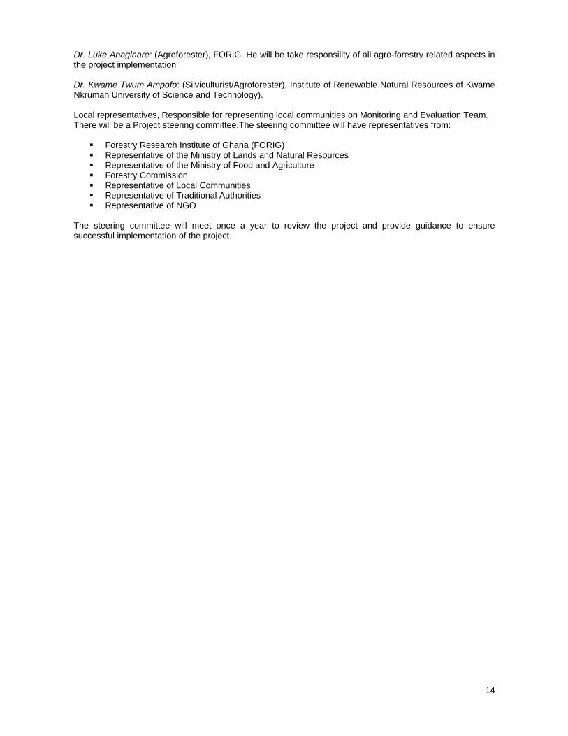
Dr. Luke Anaglaare: (Agroforester), FORIG. He will be take responsility of all agro-forestry related aspects in the project implementation Dr. Kwame Twum Ampofo: (Silviculturist/Agroforester), Institute of Renewable Natural Resources of Kwame Nkrumah University of Science and Technology). Local representatives, Responsible for representing local communities on Monitoring and Evaluation Team. There will be a Project steering committee.The steering committee will have representatives from:
Forestry Research Institute of Ghana (FORIG) Representative of the Ministry of Lands and Natural Resources Representative of the Ministry of Food and Agriculture Forestry Commission Representative of Local Communities Representative of Traditional Authorities Representative of NGO
The steering committee will meet once a year to review the project and provide guidance to ensure successful implementation of the project.

15
2.1.2 Stakeholder analysis Table 1: Stakeholder analysis
Stakeholder categories
Rights to ownership and
access to resources in the
reserves
Roles/responsibilities Interest
Relationships
Primary stakeholders Wildlife Division of Forestry Commission( FC)
Right to administer forest regulation
Enforce protection, management and controls and monitoring
To achieve sustainable management of the Ankasa conservation area
-Collaboration with other stakeholders -Conflict with respect to controlling access of resource usage
Local communities
Traditional rights of ownership and limited access to resource use
Protection of the resource
Sustainability of the resource base
Collaborate with FC; Conflict with FC; Connivance with chainsaw operators/ illegal loggers
Landowners (Traditional Authority)
Customary and legal rights
Represent communities in official decision-making processes party to timber rights allocation process
Sustainable flow of benefits Collaboration with FC; Conflict and/or connivance with illegal operators,
Office of the administrator of stool lands
No rights Manage revenue from timber resources
Ensuring forest resource revenue capture
Collaborate with FC
Illegal forest resource gatherers
Illegal operators hold no official rights
No formal legal responsibilities
Financial returns Connivance with FC and communities, Conflict with FC, and farmers
Private tree growers
rights to their own plantations
Contribute to forest resource development
Profits and business development
Collaborate with FC and communities Conflicts with illegal operators
Secondary stakeholders GTMO/GTA Logging rights Payment of fees
(stumpage fees, SRA and export levies) and maintenance of the resource
Profits Collaborate with FC and traditional authorities; Conflict with illegal chainsaw operators
Tertiary Scientific community- (FORIG, BIRD, CBUD, consultants etc )
No rights Research and provide scientific information and technical assistance for policy and management
Efficient management and utilization
Collaboration
Environmental NGOs.,
No rights Advocacy and awareness creation on forest conservation
Sustainable resource use Collaboration with government agencies academia and communities
2.1.3 Problem analysis Conservation areas are recognised as institutions, which have a key role to play in alleviation of poverty and maintenance of the global community’s critical life-support systems (IUCN, 1998). These protected areas in the country particularly forest protected areas, including the national parks, wild life sanctuary and resource reserves constitute an important component of the natural capital stock of Ghana. The importance of protected areas is emphasised by international conventions and programmes such as the Convention on Biological Diversity (CBD), the World Heritage Convention (WHC), the Ramsar Convention on Wetlands, UN Law of the Sea Convention, UNESCO’s Man and the Biosphere (MAB) Programme of the United Nations Educational, Scientific and Cultural Organisation (UNESCO) and the Global programme of World Commission on Protected Areas (WCPA). These agreements and programmes together form the backbone

16
of international policy on the establishment and management of protected areas for biodiversity conservation and sustainable use of natural and cultural resources. Following IUCN, 1994 definition, a protected area is “an area of land/ or sea especially dedicated to the protection and maintenance of biological diversity, and of natural and associated cultural resources and managed through legal or other effective means. The World Conversation Union (IUCN) has categorized forest-protected areas into a number of groups including i) strict nature reserves; ii) wilderness area; iii) national park (protected area managed mainly for ecosystem protection and recreation. That is natural area of land/ or sea designated to a) protect the ecological integrity of one or more ecosystems for present and future generations; b) exclude exploitation or occupation inimical to the purposes of designation of the area; c) Provide a foundation for spiritual, scientific, educational, recreational and visitor opportunities, all of which must be environmentally and culturally compatible); iv) natural monument; v) habitat/species management area; vi) protected landscape/seascape; vii) resource protected area. The Ankasa conservation area is the project site for this ITTO project. Ankasa Resource Reserve and the contiguous Nini-Suhien National Park are Wildlife Protected Areas located in the wet evergreen forest area of the South-Western Region of Ghana, forming a key component of West Africa’s Upper Guinean Forest Ecosystem (Living Earth Foundation 2009). The Ankasa, Nini, and Suhien Rivers all pass through the park, and are known for their rapids and waterfalls. The forest has the most biological diversity of any in Ghana, with over 300 different plant species recorded in a single hectare. According to Birdlife International 2009, Ankasa is considered to be the 'hottest' forest in Ghana, with a GHI of 301, indicating a high density of rare species. Nini Sushien (GHI 205) contains one of the few remaining blocks of relatively untouched forest in the country. This, plus the faunal diversity of the site, makes the two areas one of the most important sites for conservation of forest biodiversity in Ghana. Animal life includes the elephant, bongo, chimpanzee, Diana monkey, and 263 species of birds. However, due to encroachment of the park by local communities for unsustainable shifting cultivation for both food and cash crops as well as illegal logging in and around the park , the park is being over-exploited leading to a lot of deforestation and degradation .This leads to poverty-forest resource depletion cycle in local communities in around the Park. The impact of this is that there is reduced supply of forest products of NTFPs which the local communities depend on as well as environmental services such as increased CO2 emissions, loss of biodiversity and reduction of reduced water quality and supply, increased soil erosion. Recent studies by CARE international of the park indicates that there has been significant reduction in number of plant species including NTFP producing plants as compared to about five years ago. This increases the vulnerability of local communities to climate change as well as loss of economic development opportunities for local populations living in and around forest areas. According to Birdlife International (2009) hunting and illegal exploitation of non-timber forest products are evident in many parts of the area. Moreover, Living Earth Foundation (2009) revealed that there are extremely low levels of awareness concerning the reasons for the protected status of Ankasa among communities living on the periphery of the Reserve. All these have resulted in the poor conservation of this area leading to the continued deforestation and degradation and increased carbon emissions. These effects aggravate the poverty of already poor people, deteriorate livelihoods and lead to displacement of people and migration to urban centers such as Takoradi, Accra and other places. It leads to conflicts among the different villages around the park over the forest resources which they depend for their livelihoods. It is therefore essential that management of the conservation area (park) is aimed at conserving biodiversity, providing the ecosystem services, including reducing emissions and enhancing carbon stocks in order to mitigate climate change as well as to maintaining the livelihood of the local communities. However these aims are not being achieved because of the following: Inadequate involvement of local communities in the planning & management of the conservation area; lack of information on the financial worth of ecosystem services provided by the conservation area; lack of good governance and benefit sharing arrangements PES; and local communities do not have the capacity for monitoring REDD & lack of standard methodologies for local communities participation in monitoring REDD (Figure 2). This proposal is therefore aimed at ameliorating these conditions through participatory management and good governance so that provision of goods and environmental services by the Ankasa Conservation Area is maintained and enhanced, thereby preventing and reducing deforestation and degradation and improving livelihoods of the local communities. The interventions of this ITTO project are intended to address these challenges and support this conservation area to perform its function of reducing emissions from deforestation and degradation and enhancement of carbon stocks. This is expected to be done through a number of activities envisaged in the project. These activities include participatory development and implementation of management systems; quantifying the financial value of ecosystem services and

17
development of framework for good governance and benefit sharing arrangement for REDD. The others are the development of participatory methods for monitoring, assessment, verification and reporting on forest carbon (Figure 3). It is important to point out that these interventions are in line with overall national objectives Ghana’s National Strategy on REDD and climate change programmes. Figure 2: Problem tree

18
Figure 3: Objectives tree
SPECIFIC OBJECTIVE
OUTPUTS
ACTIVITIES
To develop and implement participatory, good governance and management system for the Ankasa conservation area, methods for measurement, assessment reporting and verification (MARV) for forest carbon as well as estimation of the value of environmental services
1.Participatory management system developed and implemented
3. Governance and benefit sharing arrangements PES developed
2. Financial value of the environmental services provided by the conservation area determined
4. Participatory methods for measurement, assessment, reporting and verification (MARV) for forest carbon developed and implemented
1.1 Identification of management system of areas surrounding conservation area
1.2 Identification of relevant local stakeholders
1.3 Strategic analysis of the drivers of forest degradation and deforestation in the Conservation area
1.4 Participatory development of management system
1.5 Implementation of developed system
1.6 Evaluation and review of management system
2.1 Identification of the ecosystem services provided by the Conservation area
2.2 Determination of the financial value of these services
2.3 Validation of the estimates of the financial values
2.4 Preparation of final report with estimates
3.1 Development of framework for good governance and benefit sharing for REDD
3.2 Development of best practice guidelines for forest governance
3.3 Stakeholder consultation to validate best practice guidelines and framework for good governance and benefit sharing
3.4 Dissemination of good practice schemes and lessons to stakeholder groups
4.1 Participatory development of verifiable method for forest carbon estimation and monitoring
4.2 Determination of baseline carbon stocks
4.3 Establishment of baselines of forest cover changes
4.4 Participatory estimation of emissions reduction and enhancement in sequestered carbon under REDD project scenario
4.5 Establishment of social baselines and institutions for monitoring REDD
4.6 Participatory development of reporting and verification methods
DEVELOPMENT OBJECTIVE
To contribute to sustainable management and conservation of Ankasa Conservation area to improve the provision of environmental services and reduce GHG emissions from deforestation and degradation as well enhance carbon stocks in tropical forests

19
2.1.4 Logical Framework Matrix
Project Element Indicators Means of verification
Assumption
Development objective To contribute to sustainable management and conservation of Ankasa Conservation area to improve the provision of environmental services and reduce GHG emissions from deforestation and degradation as well enhance carbon stocks in tropical forests
(i) The conservation are sustainably managed and conserved by 2013 (ii) The provision of environmental services enhanced by 2014 (iii) Activities which contribute to deforestation and degradation such as illegal logging, encroachment, shifting cultivation etc reduced to barest minimum by 2013. (iv) The carbon stocks in conservation area enhanced and available stock known by 2013. .
Field visits. Interaction with local communities. Report on reduction of GHG emission and enhancement of forest carbon stocks. Field visits
Local communities are willing to participate
Specific objective Specific objectives To develop and implement participatory, good governance and management system for the Ankasa conservation area, methods for measurement, assessment reporting and verification (MARV) for forest carbon as well as estimation of the value of environmental services
Every community in project area has 2 representatives involved in management.
i. Participatory management system and good governance operational for the conservation area by 2011
ii. Financial value of environmental services estimated and benefit sharing arrangements for REDD and other benefits such as PES developed and validated by 2013.
iii. Participatory measurement, assessment, reporting and verification (MARV) methods for forest carbon stocks developed by 2011
iv. Capacities of local communities would have been built in management systems and MARV by 2011.
Field visits Report on Community and management meetings Report on Training sessions for target communities Workshop reports
Stakeholders are willing to contribute to the activities in and around Conservation area
20
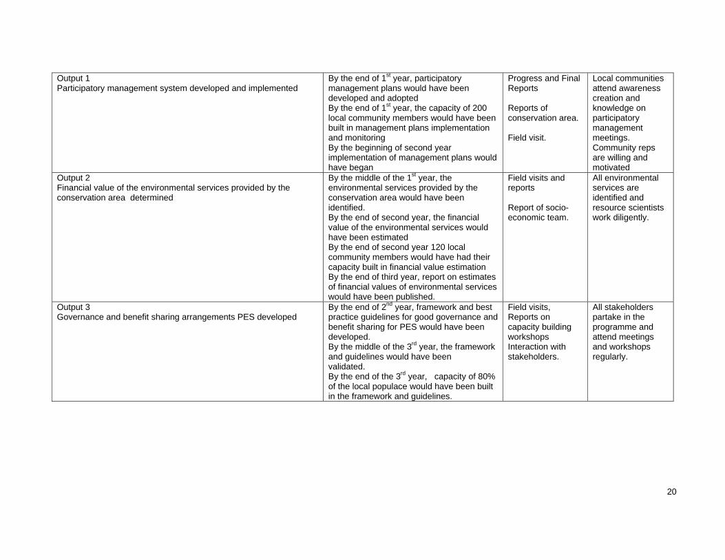
Output 1 Participatory management system developed and implemented
By the end of 1st year, participatory management plans would have been developed and adopted By the end of 1st year, the capacity of 200 local community members would have been built in management plans implementation and monitoring By the beginning of second year implementation of management plans would have began
Progress and Final Reports Reports of conservation area. Field visit.
Local communities attend awareness creation and knowledge on participatory management meetings. Community reps are willing and motivated
Output 2 Financial value of the environmental services provided by the conservation area determined
By the middle of the 1st year, the environmental services provided by the conservation area would have been identified. By the end of second year, the financial value of the environmental services would have been estimated By the end of second year 120 local community members would have had their capacity built in financial value estimation By the end of third year, report on estimates of financial values of environmental services would have been published.
Field visits and reports Report of socio-economic team.
All environmental services are identified and resource scientists work diligently.
Output 3 Governance and benefit sharing arrangements PES developed
By the end of 2nd year, framework and best practice guidelines for good governance and benefit sharing for PES would have been developed. By the middle of the 3rd year, the framework and guidelines would have been validated. By the end of the 3rd year, capacity of 80% of the local populace would have been built in the framework and guidelines.
Field visits, Reports on capacity building workshops Interaction with stakeholders.
All stakeholders partake in the programme and attend meetings and workshops regularly.

21
Output 4 Participatory methods for measurement, assessment, reporting and verification (MARV) for forest carbon developed and implemented
Participatory and verifiable methods for estimating forest carbon and monitoring developed by 2012. Capacity of 60 community members built in assessment of emission reductions and carbon stocks by 2012 Baseline data on forest cover changes available by 2012 Participatory assessment of reduction of emissions as well as carbon stocks undertaken by 2012 Social baselines and institutions for monitoring REDD established as well reporting and verification methods developed by 2013
Project reports and field visits Interaction with stakeholders Landuse change and Carbon maps
Suitable satellite images will be available for the project scene Local community members are willing and motivated to collaborate International consultant will be available on time

22
2.2 OBJECTIVES 2.2.1 Development objective and impact indicators To contribute to sustainable management and conservation of Ankasa Conservation area to improve the provision of environmental services and reduce GHG emissions from deforestation and degradation as well enhance carbon stocks in tropical forests The impacts of the development objective are:
I. The conservation are sustainably managed and conserved by 2013 II. The provision of environmental services enhanced by 2014
III. Activities which contribute to deforestation and degradation such as illegal logging, encroachment, shifting cultivation etc reduced to barest minimum by 2013.
IV. The carbon stocks in conservation area enhanced and available stock known by 2013. 2.2.2 Specific objective and outcome indicators To develop and implement participatory, good governance and management system for the Ankasa conservation area, methods for measurement, assessment reporting and verification (MARV) for forest carbon as well as estimation of the value of environmental services. The outcomes of this objective are: -
i. Participatory management system and good governance operational for the conservation area by 2011
ii. Financial value of environmental services estimated and benefit sharing arrangements for REDD and other benefits such as PES developed and validated by 2013.
iii. Participatory measurement, assessment, reporting and verification (MARV) methods for forest carbon stocks developed by 2011
iv. Capacities of local communities would have been built in management systems and MARV by 2011.

23
3 PART 3: DESCRIPTION OF PROJECT INTERVENTIONS
3.1 OUTPUTS AND ACTIVITIES 3.1.1 Outputs 1) Participatory management system developed and implemented Indicators
By the end of 1st year, participatory management plans would have been developed and adopted By the end of 1st year, the capacity of 200 local community members would have been built in
management plans implementation and monitoring By the beginning of second year implementation of management plans would have began
2) Financial value of the environmental services provided by the conservation area
determined Indicators
By the middle of the 1st year, the environmental services provided by the conservation area would have been identified.
By the end of second year, the financial value of the environmental services would have been estimated
By the end of second year 120 local community members would have had their capacity built in financial value estimation
By the end of third year, report on estimates of financial values of environmental services would have been published.
3) Governance and benefit sharing arrangements PES developed Indicators
By the end of 2nd year, framework and best practice guidelines for good governance and benefit sharing for PES would have been developed.
By the middle of the 3rd year, the framework and guidelines would have been validated. By the end of the 3rd year, capacity of 80% of the local populace would have been built in the
framework and guidelines. 4) Participatory methods for measurement, assessment, reporting and verification (MARV)
for forest carbon developed and implemented Indicators Participatory and verifiable methods for estimating forest carbon and monitoring developed
by 2012. Capacity of 60 community members built in assessment of emission reductions and carbon stocks
by 2012 Baseline data on forest cover changes available by 2012 Participatory assessment of reduction of emissions as well as carbon stocks undertaken by 2012 Social baselines and institutions for monitoring REDD established as well reporting and verification
methods developed by 2013 3.1.2 Activities 1 Participatory management system developed and implemented Activities 1.1 Identification of management system of areas surrounding conservation area 1.2 Identification of relevant local stakeholders 1.3 Strategic analysis of the drivers of forest degradation and deforestation in the Conservation area 1.4 Participatory development of management system 1.5 Implementation of developed system 1.6 Evaluation and review of management system

24
2 Financial value of the environmental services provided by the conservation area
determined Activities 2.1 Identification of the ecosystem services provided by the Conservation area 2.2 Determination of the financial value of these services 2.3 Validation of the estimates of the financial values 2.4 Preparation of final report with estimates 3 Governance and benefit sharing arrangements PES developed Activities 3.1 Development of framework for good governance and benefit sharing for REDD 3.2 Development of best practice guidelines for forest governance 3.3 Stakeholder consultation to validate best practice guidelines and framework for good governance and
benefit sharing 3.4 Dissemination of good practice schemes and lessons to stakeholder groups 4 Participatory methods for measurement, assessment reporting and verification (MARV)
of forest carbon developed and implemented Activities 4.1 Participatory development of verifiable method for forest carbon estimation and monitoring (based on
a combination of field surveys and monitoring through satellites images) 4.2 Determination of baseline carbon stocks 4.3 Establishment of baselines of forest cover changes 4.4 Participatory estimation of emissions reduction and enhancement in sequestered carbon under REDD
project scenario 4.5 Establishment of social baselines and institutions for monitoring REDD 4.6 Participatory development of reporting and verification methods 3.2 Implementation approaches and methods National Parks major objective of conservation also enhances carbon stock. These two activities are recognized under the Bali Action Plan as contributing to mitigation of climate change. However the major threats to the achievement of these objectives are deforestation and degradation. These threats if reduced will enhance biodiversity conservation, climate change mitigation and sustainable development. Thus activities which will be implemented under the technical and scientific aspects will include: Participatory management of the Conservation area: Community Resource Management Areas have been formed as part of the management of the Conservation area .However the committees responsible for theses CREMAS lack the capacities for management for conservation, including the restoration and rehabilitation of the degraded areas. They are also not motivated because they lack resources for the management. Thus the project will build the capacities for management and monitoring of the resource base as well as for restoration and rehabilitation. It will provide resources that will be needed for management including the provision of alternative livelihoods. Enhancement of biodiversity and carbon stocks, as well as reduction of emissions: In order to achieve the above objective, there will be regular monitoring of the resource base with collaboration of the local communities. Thus the local communities will be trained in the collection of all relevant data on biodiversity, carbon stocks and emissions. This will collect and update regularly. To facilitate updating an information system on this will be established. Awareness and knowledge on REDD at local and regional level developed Approaches here would involve organization of workshops at the local and regional levels. Information delivery through community radio broadcast will also be employed. Brief education materials on REDD in simple and easy to read languages (English and vernacular) will be published and distributed to relevant stakeholders.

25
Community participation in forest conservation, monitoring of illegal logging and forest encroachment improved Approaches would include stakeholder consultation at various levels through workshops and community interactions. The CREMAs will be strengthened through training, provision of logistics and incentives to improve their role in forest conservation, monitoring of illegal logging and forest encroachment Governance and benefit sharing arrangements for REDD developed, and REDD concept mainstreamed within SFM activities Local level governance structures will be strengthened. Multi-stakeholder dialogue will be used to promote policy harmonization as well as integration of local level initiatives in national strategies. Equitable benefit sharing arrangements as well as responsibilities would be developed through stakeholder consultations. The capacity of the local communities on activities that contribute to SFM would be enhanced and measures taken to mainstream these activities in their land use practices. Local level practices on SFM and good governance would be documented and lessons leant will serve input in formulating the guidelines. Verifiable method for carbon accounting and monitoring developed In order to establish a verifiable methodology for carbon monitoring and accounting, the approach will involve consideration of the most up to date, but cost effective GIS and remote sensing based REDD monitoring methodologies. Measurements will made using standard, but rigorously applied, forest sampling methods to assess forest biomass/carbon stocks. Recommended allometric equations suitable for the project area will be used to estimate biomass stocks. Without compromising on scientifically approved standards, the project will adopt measures that would make local communities play active role in carbon measurement and monitoring. Participatory GIS tools will be employed to build and enhance the capacity of the local communities in forest resource and carbon mapping. This is expected to foster transparency, help increase benefits to the local people and also reduce the transaction costs associated with carbon measurement and monitoring. Baseline emissions and potential carbon credit under REDD project scenario determined This study will explore baseline approaches that will potentially reflect the local (national) circumstances. The study will use approaches based on GIS modelling and remote sensing multi-resolution methods for mapping and qualitative analysis of baseline scenarios, estimation of emissions and enhancement of carbon stocks. GIS models that incorporate biophysical factors as well as socio-economic spatial information will be explored. Monitoring of forest cover change will done using satellite remote sensing for determining baseline deforestation rates against which future rates of change can be based. Adequate validation and accuracy assessments will be carried out to determine the levels of uncertainties contained in the estimates. All these approaches are meant to provide improved spatially explicit information on the location of carbon stocks.
26
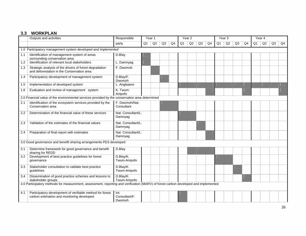
3.3 WORKPLAN Outputs and activities Responsible Year 1 Year 2 Year 3 Year 4
party Q1 Q2 Q3 Q4 Q1 Q2 Q3 Q4 Q1 Q2 Q3 Q4 Q1 Q2 Q3 Q4
1.0 Participatory management system developed and implemented
1.1 Identification of management system of areas surrounding conservation area
D.Blay
1.2 Identification of relevant local stakeholders L. Damnyag
1.3 Strategic analysis of the drivers of forest degradation and deforestation in the Conservation area
F. Dwomoh
1.4 Participatory development of management system D.Blay/F. Dwomoh
1.5 Implementation of developed system L. Anglaaere
1.6 Evaluation and review of management system K. Twum-Ampofo
2.0 Financial value of the environmental services provided by the conservation area determined
2.1 Identification of the ecosystem services provided by the Conservation area
F. Dwomoh/Nat. Consultant
2.2 Determination of the financial value of these services Nat. Consultant/L. Damnyag
2.3 Validation of the estimates of the financial values Nat. Consultant/L. Damnyag
2.4 Preparation of final report with estimates Nat. Consultant/L. Damnyag
3.0 Good governance and benefit sharing arrangements PES developed
3.1 Determine framework for good governance and benefit sharing for REDD
D.Blay
3.2 Development of best practice guidelines for forest governance
D.Blay/K. Twum-Ampofo
3.3 Stakeholder consultation to validate best practice guidelines
D.Blay/K. Twum-Ampofo
3.4 Dissemination of good practice schemes and lessons to stakeholder groups
D.Blay/K. Twum-Ampofo
4.0 Participatory methods for measurement, assessment, reporting and verification (MARV) of forest carbon developed and implemented
4.1 Participatory development of verifiable method for forest carbon estimation and monitoring developed
Int. Consultant/F. Dwomoh

27
4.2 Determination of baseline carbon stocks F.Dwomoh
4.3 Establishment of baselines of forest cover changes F. Dwomoh
4.4 Participatory estimation of emissions reduction and enhancement in sequestered carbon under REDD project scenario
L. Anglaaere /F. Dwomoh
4.5 Participatory development of reporting and verification methods
D.Blay/F. Dwomoh
4.6 Establishment of social baselines and institutions for monitoring REDD
L. Anglaaere /D.Blay

28
3.4 BUDGET 3.4.1 Master Budget Schedule Outputs/Activities
Description Budget Component
Quantity Unit Unit Cost US$
Total Cost US$
ITTO GoG
Year 1 Year 2
Year 3
Year 4
Year 1 Year 2 Year 3 Year 4
1.0 Participatory management system developed and implemented
1.1 Identification of management system of areas surrounding conservation area
Forester 11.3 1 Person-month
500 500 500 - - -
Agroforester 11.2 1 500 500 500 - - -
Socio-economist 11.6 1 500 500 500 - - -
DSA 31.1 12 100 1,200 1,200 - - -
Fuel 53 400 gallons 4 1,520 1,520 - - -
Vehicle maintenance 52 1 500 500 500 - - -
1.2 Identification of relevant local stakeholders
Forester 11.3 1 500 500 500 - - -
Agroforester 11.2 1 500 500 500 - - -
Socio-economist 11.6 1 500 500 500 - - -
DSA 31.1 9 100 900 900 - - -
Fuel 53 500 gallons 4 1,900 1,900 - - -
Vehicle maintenance 52 1 500 500 500 - - -
1.3 Strategic analysis of the drivers of forest degradation and deforestation in the Conservation area
Forester 11.3 2 500 1,000 1,000 - - -
Socio-economist 11.6 2 500 1,000 1,000 - - -
Silvuculturist 11.5 1 500 500 500 - - -
Agroforester 11.2 1 500 500 500 - - -
DSA 31.1 12 travel times
100 1,200 1,200 - - -
Forest Technicians 11.7 2 250 500 500 - - -
DSA 31.1 20 50 1,000 1,000 - - -
Fuel 53 500 gallons 4 1,900 1,900 - - -
Vehicle maintenance 52 2 700 1,400 1,400 - - -
1.4 Participatory development of management system

29
Forester 11.3 2 500 1,000 1,000 - - -
Silvuculturist 11.5 1.5 500 750 750 - - -
Agroforester 11.2 1.5 500 750 750 - - -
GIS/ Remote sensing expert 11.4 1.5 500 750 750 - - -
Socio-economist 11.6 1.5 500 750 750 - - -
DSA 31.1 30 100 3,000 3,000 - - -
Forest Technicians 11.7 5 250 1,250 1,250 - - -
DSA 31.1 20 50 1,000 1,000 - - -
Incentives- Local community representatives
12.3 200 40 8,000 8,000 - - -
Training workshop 61 1 6,000 6,000 6,000 - - -
Fuel 53 600 4 2,280 2,280 - - -
Vehicle maintenance 52 3 700 2,100 2,100 - - -
Satellite images 51 1 1,000 1,000 1,000 - - -
1.5 Implementation of developed system
Forester 11.3 3 3 3 500 4,500 - 1,500 1,500 1,500
Agroforester 11.2 3 3 3 500 4,500 - 1,500 1,500 1,500
Socio-economist 11.6 3 3 3 500 4,500 - 1,500 1,500 1,500
Silvuculturist 11.5 2 2 2 500 3,000 - 1,000 1,000 1,000
DSA 31.1 30 30 30 100 9,000 - 3,000 3,000 3,000
Forest Technicians 11.7 4 4 4 250 3,000 - 1,000 1,000 1,000
DSA 31.1 30 30 30 50 4,500 - 1,500 1,500 1,500
Incentives- Local community representatives
12.3 60 60 60 40 7,200 - 2,400 2,400 2,400
Fuel 53 550 550 550 4 6,270 - 2,090 2,090 2,090
Vehicle maintenance 52 3 3 3 700 6,300 - 2,100 2,100 2,100
1.6 Evaluation and review of management system
Silvuculturist 11.5 2 2 1 500 2,500 - 1,000 1,000 500
Socio-economist 11.6 1 1 1 500 1,500 - 500 500 500
GIS/ Remote sensing expert 11.4 2 2 2 500 3,000 - 1,000 1,000 1,000
DSA 31.1 12 12 12 100 3,600 - 1,200 1,200 1,200
Fuel 53 360 360 360 4 4,104 - 1,368 1,368 1,368

30
Vehicle maintenance 52 2 2 2 700 4,200 - 1,400 1,400 1,400
Incentives- Local communities 12.3 30 30 30 50 4,500 - 1,500 1,500 1,500
2.0 Financial value of the environmental services provided by the conservation area determined
2.1 Identification of the ecosystem services provided by the Conservation area
National consultant (ES) 13.1 2 weeks 500 1,000 1,000 - - -
Socio-economist 11.6 1 500 500 500 - - -
Forester 11.3 1 500 500 500 - - -
GIS/ Remote sensing expert 11.4 1.5 500 750 750 - - -
DSA 31.1 20 100 2,000 2,000 - - -
Fuel 53 300 4 1,140 1,140 - - -
Vehicle maintenance 52 1 700 700 700 - - -
Forest Technicians 11.7 2 250 500 500 - - -
DSA 31.1 32 50 1,600 1,600 - - -
Incentives- Local communities 12.3 500 30 15,000 15,000 - - -
2.2 Determination of the financial value of these services
National consultant (ES) 13.1 6 weeks 500 3,000 - 3,000 - -
Socio-economist 11.6 1 500 500 - 500 - -
Forester 11.3 1 500 500 - 500 - -
GIS/ Remote sensing expert 11.4 1 500 500 - 500 - -
DSA 31.1 16 100 1,600 - 1,600 - -
Fuel 53 300 4 1,140 - 1,140 - -
Vehicle maintenance 52 1 700 700 - 700 - -
2.3 Validation of the estimates of the financial values
Wokshop facilities (Including venue, facilitation, transport, materials etc)
61 1 4,000 4,000 - 4,000 - -
2.4 Preparation of final report with estimates
National consultant (ES) 13.1 2 weeks 500 1,000 - 1,000 - -
Socio-economist 11.6 1 500 500 - 500 - -
Forester 11.3 1 500 500 - 500 - -
GIS/ Remote sensing expert 11.4 1 500 500 - 500 - -
3.0 Good governance and benefit sharing arrangements PES developed

31
3.1 Determine framework for good governance and benefit sharing for REDD
Socio-economist 11.6 2 500 1,000 - 1,000 - -
Agroforester 11.2 2 500 1,000 - 1,000 - -
Silvuculturist 11.5 2 500 1,000 - 1,000 - -
Forester 11.3 2 500 1,000 - 1,000 - -
DSA 31.1 16 100 1,600 - 1,600 - -
Fuel 52 300 4 1,140 - 1,140 - -
Vehicle maintenance 53 1.5 700 1,050 - 1,050 - -
Incentives-Local communities 12.3 500 30 15,000 - 15,000 - -
3.2 Development of best practice guidelines for forest governance
Socio-economist 11.6 2 500 1,000 - - 1,000 -
Agroforester 11.2 1.5 500 750 - - 750 -
Silvuculturist 11.5 1.5 500 750 - - 750 -
Forester 11.3 3 500 1,500 - - 1,500 -
DSA 31.1 12 100 1,200 - - 1,200 -
Fuel 52 140 4 532 - - 532 -
Vehicle maintenance 53 1 700 700 - - 700 -
3.3 Stakeholder consultation to validate best practice guidelines
Wokshop facilities (Including venue, facilitation, transport, materials etc)
61 1 5,000 5,000 - - 5,000 -
3.4 Dissemination of good practice schemes and lessons to stakeholder groups
Wokshop facilities (Including venue, facilitation, transport, materials etc)
61 1 5,500 5,500 - - 5,500 -
4.0 Participatory methods for measurement, assessment, reporting and verification (MARV) of forest carbon developed and implemented
4.1 Participatory development of verifiable method for forest carbon estimation and monitoring developed
International Consultant (Carbon accounting)
14.1 20 Person-days
500 10,000 - 10,000 - -
International travel (return ticket) 32.2 1 4,000 4,000 - 4,000 - -
DSA 31.2 20 200 4,000 - 4,000 - -
GIS/ Remote sensing expert 11.4 2 Person-months
500 1,000 - 1,000 - -
Forester 11.3 2 500 1,000 - 1,000 - -
Silvuculturist 11.5 2 500 1,000 - 1,000 - -

32
DSA 31.1 30 100 3,000 - 3,000 - -
Forest Technicians 11.7 2 250 500 - 500 - -
DSA 31.1 40 50 2,000 - 2,000 - -
Fuel 53 300 4 1,140 - 1,140 - -
Vehicle maintenance 52 1 700 700 - 700 - -
Incentives - Local community trainees
12.3 60 30 1,800 - 1,800 - -
Ipaqs (with GPS+ArcPad software) 44.5 5 2,000 10,000 10,000 - - -
Purchase of base maps 51 1 1,000 1,000 - 1,000 - -
Misc. Training materials 61 60 5 300 - 300 - -
4.2 Determination of baseline carbon stocks
GIS/ Remote sensing expert 11.4 3 Person-months
500 1,500 - 1,500 - -
Forester 11.3 2 500 1,000 - 1,000 - -
Silvuculturist 11.5 2 500 1,000 - 1,000 - -
DSA 31.1 36 100 3,600 - 3,600 - -
Forest Technicians 11.7 8 250 2,000 - 2,000 - -
DSA 31.1 84 50 4,200 - 4,200 - -
Fuel 53 900 4 3,420 - 3,420 - -
Vehicle maintenance 52 2 700 1,400 - 1,400 - -
Incentives -Local community members- (Labour)
12.3 60 25 1,500 - 1,500 - -
4.3 Establishment of baselines of forest cover changes
GIS/ Remote sensing expert 11.4 2 2 2 Person-months
500 3,000 1,000 - 1,000 1,000
Forester 11.3 1 1 1 500 1,500 500 - 500 500
DSA 31.1 14 14 14 100 4,200 1,400 - 1,400 1,400
Forest Technicians 11.7 2 2 2 250 1,500 500 - 500 500
DSA 31.1 14 14 14 50 2,100 700 - 700 700
Incentives -Local communities 12.3 25 25 25 30 2,250 750 - 750 750
ArcGIS software 9.3 -Network version (ESRI Inc.)
44.4 1 Pack 18,000 18,000 18,000 - - -
Erdas Imagine software 9.2- Network Version (Leica Inc.)
44.4 1 Pack 15,000 15,000 15,000 - - -
Satellite images 51 1 2 1 1 1,500 7,500 1,500 3,000 1,500 1,500
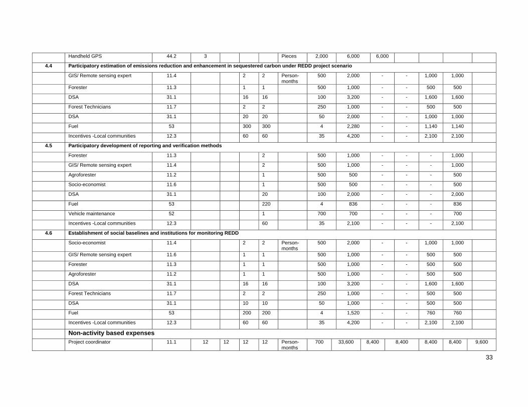
33
Handheld GPS 44.2 3 Pieces 2,000 6,000 6,000
4.4 Participatory estimation of emissions reduction and enhancement in sequestered carbon under REDD project scenario
GIS/ Remote sensing expert 11.4 2 2 Person-months
500 2,000 - - 1,000 1,000
Forester 11.3 1 1 500 1,000 - - 500 500
DSA 31.1 16 16 100 3,200 - - 1,600 1,600
Forest Technicians 11.7 2 2 250 1,000 - - 500 500
DSA 31.1 20 20 50 2,000 - - 1,000 1,000
Fuel 53 300 300 4 2,280 - - 1,140 1,140
Incentives -Local communities 12.3 60 60 35 4,200 - - 2,100 2,100
4.5 Participatory development of reporting and verification methods
Forester 11.3 2 500 1,000 - - - 1,000
GIS/ Remote sensing expert 11.4 2 500 1,000 - - - 1,000
Agroforester 11.2 1 500 500 - - - 500
Socio-economist 11.6 1 500 500 - - - 500
DSA 31.1 20 100 2,000 - - - 2,000
Fuel 53 220 4 836 - - - 836
Vehicle maintenance 52 1 700 700 - - - 700
Incentives -Local communities 12.3 60 35 2,100 - - - 2,100
4.6 Establishment of social baselines and institutions for monitoring REDD
Socio-economist 11.4 2 2 Person-months
500 2,000 - - 1,000 1,000
GIS/ Remote sensing expert 11.6 1 1 500 1,000 - - 500 500
Forester 11.3 1 1 500 1,000 - - 500 500
Agroforester 11.2 1 1 500 1,000 - - 500 500
DSA 31.1 16 16 100 3,200 - - 1,600 1,600
Forest Technicians 11.7 2 2 250 1,000 - - 500 500
DSA 31.1 10 10 50 1,000 - - 500 500
Fuel 53 200 200 4 1,520 - - 760 760
Incentives -Local communities 12.3 60 60 35 4,200 - - 2,100 2,100
Non-activity based expenses Project coordinator 11.1 12 12 12 12 Person-
months 700 33,600 8,400 8,400 8,400 8,400 9,600

34
Administrative staff 11.8 12 12 12 12 Person-months
200 9,600 2,400 2,400 2,400 2,400 9,600
Driver 12.1 12 12 12 12 Person-months
300 14,400 3,600 3,600 3,600 3,600
Project Secretary 12.2 12 12 12 12 Person-months
300 14,400 3,600 3,600 3,600 3,600
4WD pick up 43 1 40,000 40,000 40,000 - - -
Premises 41 1 1 1 1 Per year 2,000 8,000
Land 42 1 1 1 1 Per year 1,200 4,800
Office supplies (Papers, cartridges, Papers, cartridges, toners,etc)
54 1 1 1 1 Per year 1,000 4,000 1,000 1,000 1,000 1,000 4,000
Computer and accessories (1 laptop + 4 desktops, printer, scanner, camera, LCD projector)
44.1 1 lump sum 14,000 14,000 14,000 - - -
Plotter (Size A0 for GIS/RS lab) 44.3 1 Sets 10,000 10,000 10,000 - - -
Paper & ink for plotter 51 1 lump sum 2,500 2,500 2,500 - - -
Clinometer 44.2 2 units 600 1,200 1,200 - - -
Calipers 44.2 4 Pairs 400 1,600 1,600 - - -
Diameter tapes 44.2 5 Pieces 300 1,500 1,500 - - -
Weighing scale 44.2 2 Sets 500 1,000 1,000 - - -
Digital fish eye-lens camera 44.2 1 Sets 2,000 2,000 2,000 - - -
Consumables 51 1 1 1 1 Lump sum/year
1,200 4,800 1,200 1,200 1,200 1,200 2,000
Media, publication & education 55 1 1 1 1 Per year 1,500 6,000 1,500 1,500 1,500 1,500
Attending seminars, workshops & conferences
32.1 1 1 1 1 Per year 4,500 18,000 4,500 4,500 4,500 4,500
Steering Committee meeting 63 1 1 1 1 event/year
2,000 8,000 2,000 2,000 2,000 2,000 4,000
Total 550,122 228,190 145,048 92,840 84,044 42,000
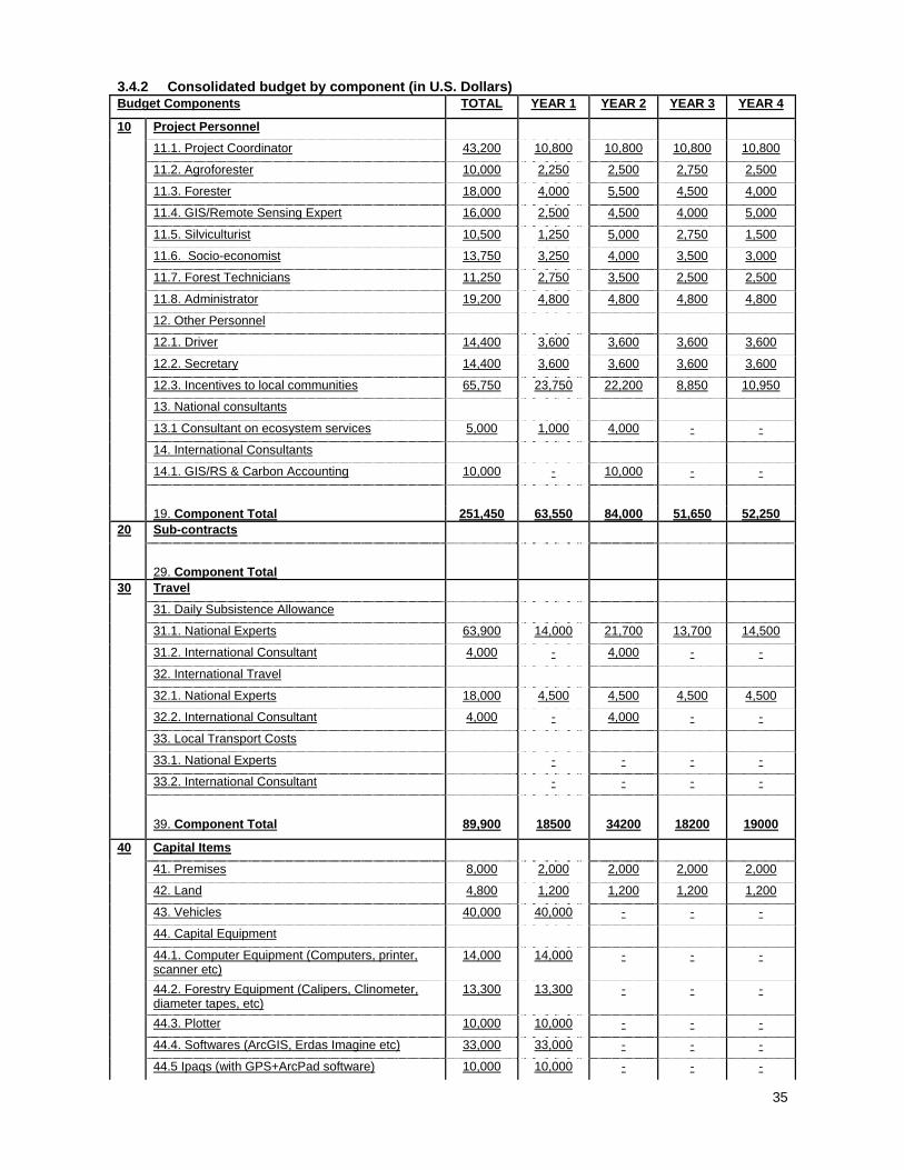
35
3.4.2 Consolidated budget by component (in U.S. Dollars) Budget Components TOTAL YEAR 1 YEAR 2 YEAR 3 YEAR 4
10 Project Personnel
11.1. Project Coordinator 43,200 10,800 10,800 10,800 10,800
11.2. Agroforester 10,000 2,250 2,500 2,750 2,500
11.3. Forester 18,000 4,000 5,500 4,500 4,000
11.4. GIS/Remote Sensing Expert 16,000 2,500 4,500 4,000 5,000
11.5. Silviculturist 10,500 1,250 5,000 2,750 1,500
11.6. Socio-economist 13,750 3,250 4,000 3,500 3,000
11.7. Forest Technicians 11,250 2,750 3,500 2,500 2,500
11.8. Administrator 19,200 4,800 4,800 4,800 4,800
12. Other Personnel
12.1. Driver 14,400 3,600 3,600 3,600 3,600
12.2. Secretary 14,400 3,600 3,600 3,600 3,600
12.3. Incentives to local communities 65,750 23,750 22,200 8,850 10,950
13. National consultants
13.1 Consultant on ecosystem services 5,000 1,000 4,000 - -
14. International Consultants
14.1. GIS/RS & Carbon Accounting 10,000 - 10,000 - -
19. Component Total 251,450 63,550 84,000 51,650 52,250 20 Sub-contracts
29. Component Total 30 Travel
31. Daily Subsistence Allowance
31.1. National Experts 63,900 14,000 21,700 13,700 14,500
31.2. International Consultant 4,000 - 4,000 - -
32. International Travel
32.1. National Experts 18,000 4,500 4,500 4,500 4,500
32.2. International Consultant 4,000 - 4,000 - -
33. Local Transport Costs
33.1. National Experts - - - -
33.2. International Consultant - - - -
39. Component Total 89,900 18500 34200 18200 19000
40 Capital Items
41. Premises 8,000 2,000 2,000 2,000 2,000
42. Land 4,800 1,200 1,200 1,200 1,200
43. Vehicles 40,000 40,000 - - -
44. Capital Equipment
44.1. Computer Equipment (Computers, printer, scanner etc)
14,000 14,000 - - -
44.2. Forestry Equipment (Calipers, Clinometer, diameter tapes, etc)
13,300 13,300 - - -
44.3. Plotter 10,000 10,000 - - -
44.4. Softwares (ArcGIS, Erdas Imagine etc) 33,000 33,000 - - -
44.5 Ipaqs (with GPS+ArcPad software) 10,000 10,000 - - -

36
49. Component Total 133,100 123500 3200 3200 3200
50 Consumable Items
51. Raw materials (Satellite images etc) 18,800 6,700 5,700 3,200 3,200
52. Spares (including vehicle manitenance) 20,872 5,200 7,440 4,032 4,200
53. Fuel & Utilities 31,200 8,740 10,208 6,058 6,194
54. Office Supplies 8,000 2,000 2,000 2,000 2,000
55. Media, Publication and Education 6,000 1,500 1,500 1,500 1,500
59. Component Total 84,872 24,140 26,848 16,790 17,094
60 Miscellaneous
61. Sundry 20,800 6,000 4,300 10,500 -
62. Auditing 4,800 1,200 1,200 1,200 1,200
63. Steering Committee 12,000 3,000 3,000 3,000 3,000
69. Component Total 37,600 10200 8500 14700 4200
SUBTOTAL 1 596,922 239890 156748 104540 95744
70 National Managment Costs
71 Executing agency management cost (10% of total budget by activity)
59,692
79. Component Total 59,692 80 Project Monitoring and Administration
81. ITTO Monitoring and Review 40,000
82. ITTO midterm, final, ex-post Evaluation Costs 15,000
SUBTOTAL 2 711,614
83. ITTO Programme Support Costs (8% ) 48,794
100 GRAND TOTAL 760,408
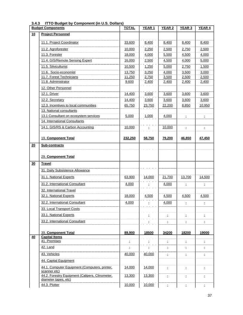
37
3.4.3 ITTO Budget by Component (in U.S. Dollars) Budget Components TOTAL YEAR 1 YEAR 2 YEAR 3 YEAR 4
10 Project Personnel
11.1. Project Coordinator 33,600 8,400 8,400 8,400 8,400
11.2. Agroforester 10,000 2,250 2,500 2,750 2,500
11.3. Forester 18,000 4,000 5,500 4,500 4,000
11.4. GIS/Remote Sensing Expert 16,000 2,500 4,500 4,000 5,000
11.5. Silviculturist 10,500 1,250 5,000 2,750 1,500
11.6. Socio-economist 13,750 3,250 4,000 3,500 3,000 11.7. Forest Technicians 11,250 2,750 3,500 2,500 2,500
11.8. Administrator 9,600 2,400 2,400 2,400 2,400
12. Other Personnel
12.1. Driver 14,400 3,600 3,600 3,600 3,600
12.2. Secretary 14,400 3,600 3,600 3,600 3,600
12.3. Incentives to local communities 65,750 23,750 22,200 8,850 10,950
13. National consultants
13.1 Consultant on ecosystem services 5,000 1,000 4,000 - -
14. International Consultants
14.1. GIS/RS & Carbon Accounting 10,000 - 10,000 - -
19. Component Total 232,250 58,750 79,200 46,850 47,450
20 Sub-contracts
29. Component Total
30 Travel
31. Daily Subsistence Allowance
31.1. National Experts 63,900 14,000 21,700 13,700 14,500
31.2. International Consultant 4,000 - 4,000 - -
32. International Travel
32.1. National Experts 18,000 4,500 4,500 4,500 4,500
32.2. International Consultant 4,000 - 4,000 - -
33. Local Transport Costs
33.1. National Experts - - - -
33.2. International Consultant - - - -
39. Component Total 89,900 18500 34200 18200 19000 40 Capital Items 41. Premises - - - - -
42. Land - - - - -
43. Vehicles 40,000 40,000 - - -
44. Capital Equipment
44.1. Computer Equipment (Computers, printer, scanner etc)
14,000 14,000 - - -
44.2. Forestry Equipment (Calipers, Clinometer, diameter tapes, etc)
13,300 13,300 - - -
44.3. Plotter 10,000 10,000 - - -

38
44.4. Softwares (ArcGIS, Erdas Imagine etc) 33,000 33,000 - - -
44.5 Ipaqs (with GPS+ArcPad software) 10,000 10,000 - - -
49. Component Total 120,300 120300 0 0 0 50 Consumable Items
51. Raw materials (Satellite images etc) 16,800 6,200 5,200 2,700 2,700
52. Spares (including vehicle manitenance) 20,872 5,200 7,440 4,032 4,200
53. Fuel & Utilities 31,200 8,740 10,208 6,058 6,194
54. Office Supplies 4,000 1,000 1,000 1,000 1,000
55. Media, Publication and Education 6,000 1,500 1,500 1,500 1,500
59. Component Total 78,872 22,640 25,348 15,290 15,594 60 Miscellaneous
61. Sundry 20,800 6,000 4,300 10,500 -
62. Auditing 4,800 1,200 1,200 1,200 1,200
63. Steering Committee 8,000 2,000 2,000 2,000 2,000
69. Component Total 33,600 9200 7500 13700 3200
SUBTOTAL 1 554,922 229,390 146,248 94,040 85,244
70 National Managment Costs
79. Component Total
80 Project Monitoring and Administration
81. ITTO Monitoring and Review 40,000
82. ITTO midterm, final, ex-post Evaluation Costs 15,000
SUBTOTAL 2 609,922
83. ITTO Programme Support Costs (8% on items 10 to 82 above)
48,794
100 GRAND TOTAL 658,716
3.4.4 Executing Agency Budget by Component (in U.S. Dollars) Budget Components TOTAL YEAR 1 YEAR 2 YEAR 3 YEAR 4
10 Project Personnel
11.1. Project Coordinator 9,600 2,400 2,400 2,400 2,400
11.8. Administrative staff 9,600 2,400 2,400 2,400 2,400
19. Component Total 19,200 4,800 4,800 4,800 4,800
20 Sub-contracts
29. Component Total
30 Travel

39
39. Component Total - - - - -
40 Capital Items
41. Premises 8,000 2,000 2,000 2,000 2,000
42. Land 4,800 1,200 1,200 1,200 1,200
49. Component Total 12,800 3200 3200 3200 3200
50 Consumable Items
51. Raw materials 2,000 500 500 500 500
54. Office Supplies 4,000 1,000 1,000 1,000 1,000
59. Component Total 6,000 1,500 1,500 1,500 1,500
60 Miscellaneous
61. Sundry - - - -
62. Auditing - - - -
63. Steering Committee 4,000 1,000 1,000 1,000 1,000
69. Component Total 4,000 1000 1000 1000 1000
SUBTOTAL 1 42,000 10,500 10,500 10,500 10,500
70 National Managment Costs
Executing Agency Management Costs (10% 0f Total of Overall Project Budget by Activity)
59,692
79. Component Total 59,692
100 GRAND TOTAL 101,692

40
3.5 ASSUMPTIONS, RISKS, SUSTAINABILITY 3.5.1 Assumptions and risks The project has the objective of empowering local communities to participate in the management and governance of the National Park in to achieve its prime aim of and provision of environmental services. Thus major stakeholders in this regards are the local communities and the Officials of Wildlife Division who are currently managing of the Park. However may be due to technical arrogance on the part of administrators and misunderstanding on the part of the local communities there may be conflict between these two major stakeholders especially as concerned with the utilization of goods and services. This conflict if not minimized will demotivate the local communities and thus prevent from the project activities. To minimize the risks the following action will be taken.
Determination of potential risks and actions to mitigate these through participatory consultation with all stakeholders.
Development of conflict resolution mechanism between the stakeholders Empower local communities in the implementation of the mechanism Enhance community forest enterprise around the conservation area to promote alternative
livelihoods to local communities Scale up disseminate good lessons learnt in the implementation of project to the wider community in
the Nzema East District within which Ankasa National Park is located as well as throughout the country.
3.5.2 Sustainability To ensure sustainability of management strategies identified and implemented under the project, community-focussed management would be the foundation upon which the project team’s approach in dealing with the communities in the project area would be built. The development of a high level of community involvement and organisation will be an overall objective that will be taken into consideration at all stages of the project cycle. Achieving environmental stability and sustainable provision of environmental services are of prime essence to Ghana. In view of this the project has the support of the government and all the local communities. Forestry projects are essentially long term. However it is hoped that the project objectives will be achieved by the year 2014. However lessons learnt will serve as significant input in the overall development of national strategy on REDD. The study area will serve for the transfer of knowledge from participating communities to non-participating ones. The area can therefore be adopted as an operation REDD project site in Ghana. There will thus be promotion of REDD implementation to ensure that Ghana benefits from the international carbon market. Additionally, the following measures will be pursued to ensure sustainability of the outcomes and outputs of the project after ITTO funding has expired: (i) Incorporate the project into the national programme on poverty reduction and economic
growth. Thus the project can be presented as an innovative model to complement existing efforts on collaborative forest management being pursued by the Forestry Commission
(ii) Ensure that the activities are mainstreamed into the yearly plan of action of the Wildlife Division of the Forestry Commission. This will ensure that the activities are budgeted for an implemented in their plan of operations
(iii) Incorporate the programme in the Environmental Plan of the Jomoro District Assembly so that the assembly can budget for it and also ensure that it is implemented. Already, the District Assembly and the Unit Committees are enthusiastic in getting their areas benefit from the emerging carbon market. Therefore political support from the local government is high.
(iv) This project recognizes that building on and enhancing community-based forest management is essential to efficiently prevent and/or monitor deforestation and degradation. Already, Community Resource Management Areas (CREMAs) are established in the area. These are community-lead with structures in the communities. This ITTO project will work closely with the CREMAs and ensure gradual integration of the project activities into the activities of the CREMAs.
(v) Promote the use of study site as a pilot site by the FCPF by sharing data with them. (vi) FORIG will continue to use the area as a research site for long-term studies on forest carbon
accounting, assessment and monitoring of land use changes, forest resources modelling and other relevant researchable issues.

41
4 PART 4: IMPLEMENTATION ARRANGEMENTS 4.1 Organization structure and stakeholder involvement mechanisms 4.1.1 Executing agency and partners The Executing Agency of the Project will be the FORIG and the collaborating partners will be Wildlife Division of the Forestry Commission, Faculty of of Renewable Natural Resources of the Kwame Nkrumah University of Science and Technology (KNUST) and most importantly the local communities (Figure 4).
Figure 4: Organizational structure Responsibilities FORIG:
Will nominate project coordinator Submit all reports relevant to the project implementation Ensure smooth implementation of the project Facilitate writing of all publications including scientific papers Collaborate with others to ensure smooth running of the project
WILDLIFE Division: Provide technical input to the preparation of management plans Facilitate in the identification of ecosystem services provided by the conservation area Liase with local communities to ensure effective participation
KNUST Responsible for all training sessions
LOCAL Communities Will be responsible for implementation of most of the field activities
The Wildlife Division will contribute to the identification of the communities to take part in the project, other stakeholders and to provide technical advice on management. The Faculty of Renewable Natural Resources of the University will contribute to training the local communities and in preparing progress reports. 4.1.2 Project management team Key project staff and their responsibilities will be: Dr. Dominic Blay: (Project Coordinator, Foresters/Ecologist), Forestry Research Institute of Ghana (FORIG). He is responsible for the design of the project; the execution and coordination of all aspects of the project;

42
collection and collation of project reports for all participating scientists and community project teams. He will also be take charge of all forestry & ecological aspects of the project. Mr. Francis K. Dwomoh: (GIS/Remote Sensing Expert and Silvicultrist), FORIG. He will be responsible for all aspects of the project related to remote sensing and GIS operations. Mr Lawrence Damnyag: (Social-economist), FORIG. He will be in charge of all socio-economic studies and for organizing workshops. Dr. Luke Anglaare (Agroforester), FORIG. He will be take responsibility of all agro-forestry related aspects in the project implementation Dr. Kwame Twum Ampofo: (Silviculturist/Agroforester), Institute of Renewable Natural Resources of Kwame Nkrumah University of Science and Technology). Local representatives, Responsible for representing local communities on Monitoring and Evaluation Team 4.1.3 Project steering committee The steering committee will have representatives from:
Forestry Research Institute of Ghana (FORIG) Representative of the Ministry of Lands and Natural Resources Representative of the Ministry of Food and Agriculture Forestry Commission Representative of Local Communities Representative of Traditional Authorities Representative of NGO The steering committee will meet once a year to review the project and provide guidance to ensure
successful implementation of the project. 4.1.4 Stakeholder Involvement and Mechanisms Stakeholders will be involved through participatory planning and implementation. Their role would include strategic analysis of the drivers of deforestation; identification and valuation of ecosystem services; determination of good governance and benefit sharing arrangements. Stakeholders at the local communities would play active role in the overall execution of field activities, especially on forest monitoring and carbon accounting. To this end, capacity of the communities in carbon accounting and forest resource mapping are key components of the project activities. 4.2 Reporting, review, monitoring and evaluation (a) Project Progress Report The project coordinator will be responsible for the preparation of project process reports minimum four weeks before each ITTO monitoring visit and two months before ITTC sessions. (b) Project Completion Report The project coordinator will be responsible for the compilation of the project completion report and have it submitted to ITTO within three months of the project completion. (c) Project Technical Report Project technical reports will be prepared by project staff responsible for specific technical activities, peer reviewed by other project staff and submitted to ITTO by the project coordinator. All technical reports will be disseminated at the national, sub-regional as well as international level in order to share lessons learnt by this project with other actors in REDD. (d) Monitoring, Review and Steering Committee's visits ITTO monitoring visits will be carried out every 12 months, a total of 4 visits throughout the project cycle. An internal monitoring and self-evaluation for the project will be carried out .To do this, a monitoring committee of five (5) members made of three members selected by the community and two project team members in each project area. This tea\m will be responsible for ensuring the successful execution of project in their respective areas and will required to submit progress on activities in their areas bi- yearly (before submission to progress report to ITTO) to the project coordinator .

43
The results of the self-evaluation will be used in fine-tuning the activities foreseen for the rest of the project cycle. The project steering committee will meet once a year to discuss project technical details as well as to approve certain documents, such as the yearly plan of operations (YPO). 4.3 Dissemination and on mainstreaming of project learning Dissemination and on mainstreaming REDD activities into SFM would emerge out of this study. In all, technical lessons learnt will be essential information for the development of overall national REDD strategy for Ghana. Technologies developed on forest carbon inventory and monitoring will be a significant contribution in the development of methodologies for the realisation of REDD in tropical countries. This in particular will improve national carbon accounting and further strengthen Ghana’s commitment to the global climate agenda, particularly the UNFCCC and the Kyoto Protocol. 4.3.1 Disseminating of project results Results of the project will be disseminated as follows:
(i) Final workshop will be held at the end of the project to disseminate the results of the project as well as agree on follow up actions.
(ii) Web site developed on the Internet to disseminate the results of each activity completed (iii) Scientific publications will be made scientific journals. (iv) Media publications will also be made especially during the steering committee meeting.
4.3.2 Mainstreaming of project learning Technical lessons learnt will be used for the development of overall national REDD strategy for Ghana and technologies developed on forest carbon inventory and monitoring especially by local communities will be significant contribution in the development of methodologies for the realisation of REDD in other communities in Ghana and in other tropical countries in Africa. This in particular will improve national carbon accounting and further strengthen Ghana’s commitment to the global climate agenda, particularly the UNFCCC and the Kyoto Protocol.
44
ANNEX 1. PROFILES OF THE EXECUTING AND COLLABORATING AGENCIES
FORESTRY RESEARCH INSTITUTE OF GHANA (FORIG) The Forestry Research Institute of Ghana is one of the 13 institutes of the Council for Scientific and Industrial Research (CSIR). It is located at Fumesua near Kumasi in the Ashanti Region of Ghana. It started as a research unit within the Forestry Department in 1962. It was fully established as a research institute and named FOREST PRODUCTS RESEARCH INSTITUTE (FPRI) under the then Ghana Academy of Sciences in 1964 and in 1968 placed under the Council for Scientific and Industrial Research (CSIR).By Act of Parliament (Act 405) the Institute was transferred from the CSIR to the Forestry Commission in 1980. In 1991, the name of the Institute was changed to Forestry Research Institute of Ghana to reflect the widening scope of its research activities. In 1993, by another Act of Parliament (Act 453) the Institute was reverted to the CSIR. The goals of FORIG are:
Conduct user-focused research commissioned by its client Generate and disseminate useful scientific and appropriate technological information directly to its
clients, stakeholders and the general public in a timely manner. Anticipate and address the major research information needs that are likely to face managers, policy
makers, and stakeholders in the future, (i.e. develop capacity for quick response to changing circumstances)
Enhance its institutional capability through appropriate training programmes to address technical problems in forestry resources protection, sustainable management, and utilization.
Contribute, through research to the social, economic and environmental well-being of the people of Ghana
Enhance the sustainable management, conservation and efficient utilization of Ghana’s forest resources
Foster strong linkages, through collaborative research across disciplines among forestry professional, stakeholders and external institutions.
FORIG has the following objectives:
Develop technologies for sustainable management of natural forests and biodiversity conservation Develop technologies fundamental to the success of plantation forestry. Generate technological
properties and develop appropriate processing techniques for the efficient utilization of Ghana’s forest resources
Enhance sustainable management and utilization of non-timber forest products (NTFPs) Mobilize, process and disseminate information critical to the management of Ghana’s forest
resources Strengthen capacity and use it for optimum research and commercialized services Establish mechanism for attracting financial assistance from donors, private and public institutions
for research Expertise: The Institute has specialists in Silviculture, Entomology, Forest botany, Forest ecology, Seed technology, Mensuration / Statistics, Genetics, Agro-forestry, Socio-Economics and Marketing and Information Science, GIS and Remote Sensing. Staff Strength: The Institute has total staff strength of 278 made up of 47 senior members 17 who have Ph.D degrees and the remaining with M.Sc degrees and 61 non-research senior officers. Facilities: The Institute's permanent offices and laboratories are located at Fumesua, near Kumasi. It has research centres at Bobiri and Amantia both in the Moist, Semi-Deciduous Forest Zone, Benso in the Wet Evergreen Zone, and Bolgatanga in the Savannah zone. There are also research stations at Subri, Afram Headwaters, Pra-Anum, Accra plains, Northern grassland, Bia Tano and Asenanyo. Externally Funded Projects FORIG has won a number of competitive grants/donor supports for a wide variety of projects. Currently, there are over 10 donor-funded projects. These are in the areas of forest management, wood utilization and construction, sivliculture and management and entomology. Donors/sponsors are varied and range from bilateral support through to researcher support. Our donors include ITTO, DFID, AAS and the European Union. Below is the list of some on-going donor sponsored projects:

45
o Silviculture and Economics of Improved Natural Forest Management in Ghana o Processing and Utilization of Logging Residues through Collaboration with Local Communities and
Forest Industries o Development of an Integrated Strategy for Reduction of Shoot Borer Impact on African Mahogany in
the Tropical Humid Forest of Africa o Increasing Productivity and Quality of West African Teak Plantations using Genetic Diversity and
Sustainable Management o Rehabilitation of Mined Sites o Rehabilitation of Degraded Forests in the Savanna o Rehabilitation of Degraded Forests through Collaboration with Local Communities o Sustainable Development of Bamboo Resources in Ghana and Togo (AFORNET) o Genetic Improvement, Productivity and Biodiversity Conservation of T. scleroxylon (AFORNET) o Flower induction and mass productivity and biodiversity of T. scleroxylon using tissue culture
(TWAS) o Alternative mixed plantation systems and restoration strategies for conservation and sustainable
production of timber species in Ghana (ITTO) o Silvicultural strategies for mitigating shootborer impact on African Mahogany; Effect of pruning and
companion planting (IFS) Responding to the challenges and demands of national and global trends FORIG is an active member of prestigious international associations such as Commonwealth Forestry Association, International Union of Forestry Research Organizations (IUFRO) and International Union for the Conservation of Nature (IUCN). ANNEX 2. TASKS AND RESPONSIBILITIES OF KEY EXPERTS PROVIDED BY THE EXECUTING AGENCY Dominic BLAY – Principal Research Scientist – Forestry Research Institute of Ghana Dr. Blay is a principal research scientist at the Forestry Research Institute of Ghana with an expertise on restoration of degraded lands, forest fires, rural forestry and local community collaboration as well as monitoring and evaluation. He has a wide scientific experience on forestry including field experience from different parts of Ghana, Nigeria, Papua New Guinea, Brazil and Austria. He has been the project leader of numerous researches and field projects in his country and is a member of various forestry related professional associations.
Date and place of birth and nationality: 04 August 1950 Ghana, Ghanaian Field and institution of graduation: Botany and Biochemistry, University of Ghana, Legon, Ghana Field and institution of post-graduation: M.Sc. Forestry Resources Management, University of
Ibadan, Nigeria, Dr. rer. nat. tech. Forestry Ecology, Universitat fur Bodenkultur, Vienna, Austria. Lawrence DAMNYAG – Environmental and Natural Resources Economist He is a Research Scientist-(Forest Economics) at the Forestry Research Institute of Ghana. His expertise and relevant experiences include questionnaire design and data analysis, Rural households poverty-environment/forest analysis, Farm/environmental/forest resources valuation, Natural resources decision analysis and working with local communities on natural resources management. He has experience in the application of the following software for data and decision analysis; i) Eviews, ii) SPSS, iii) LIMDEP and v) DEFINITE
Date and place of birth and nationality: 04 July 1963 Ghana, Ghanaian Field and institution of graduation: Economics with statistics, University of Ghana, Legon, Ghana Field and institution of post-graduation: M.Phil Economics, specializing in Econometrics and
Environmental and Natural Resources Economics Francis K. DWOMOH – Remote Sensing & GIS Expert/ Silviculturist Mr. Francis Kwabena Dwomoh is currently a Research Scientist at the Forestry Research Institute of Ghana. He is a silviculturist and an expert in Remote Sensing and Geographic Information Systems (GIS) with specialisation in the management of natural resources. His current resarch interests include monitoring and modelling of tree/forest resources, tropical land-cover/land-use changes and ecosystem services. More specific interests are the application of Remote Sensing and GIS techniques in fire behaviour modelling; assessment and modelling of carbon sequestration/emissions from tropical forests. He has worked very well with local communities having worked as a silviculturist on the ITTO funded project ‘Rehabilitating Degraded Forest through Collaboration with Local Communities PD030/97 Rev.6 (F)’.
Date and place of birth and nationality: 7th February, 1978 Ghana, Ghanaian Field and institution of graduation: BSc. (Natural Resources Management) - KNUST, Kumasi, Ghana

46
Field and institution of post-graduation: MSc. (Geo-information Science and Earth Observation for Natural Resource Management). ITC, Enschede, The Netherlands & KNUST, Kumasi, Ghana
Luke Anglaare – Agroforester Luke Anglaare is a Senior Research Scientist at the Forestry Research Institute of Ghana. He has expertise in Agroforestry and forest management. He has wide experience in community forestry, landuse dynamics as well as the design of agroforestry interventions.
Field and institution of graduation: BSc. Natural Resources Management, KNUST, Kumasi-Ghana, Field and institution of post-graduation: M.Sc. Agroforestry, KNUST, Kumasi-Ghana; Ph. D.
Agroforestry, University of Wales, Bangor

47
ANNEX 3: EXPERT COMMENTS AND THEIR RESPONSES
Comment 1: The proposal does not provide detailed information on the social aspects of the local communities in and around the Ankasa Conservation Area. Please revise
This revision is under section 4.3.2.1 4.3.2.1 Social aspects
The population of the district is about 111,348 with a density of 83 persons per km2 and an annual growth rate of 3%. (2000 Population and Housing Census). The demographic structure of the Jomoro District has some common features with other rural districts in Ghana such as low density, high mortality rates and relatively high out migration. However, there are some specific characteristics due to the low development level of the district. The population of the district fell from 45, 162 in 1960 to 37,685 in 1970. It sharply rose to 70,881 in 1984 and that of the year 2000 was 111,348. The population density of 83 persons per square kilometer in 2000 portrays a rural district where population is not yet a problem. The male population of the district constitutes 49.7% while the female takes 50.3%. This shows a deviation from the Regional figure that indicates higher percentage for males than females. The population of the district is 5.8% of that of the region. The dependency ratio is approximately 1:1. The male population of Jomoro constitutes 49.7% while that of female takes 50.3%. The 0-14 cohorts constitute 67 percent of the total population while the aged 65 years and above make only 2 percent. The dependant population in the district, that is those in cohorts 0-14 years plus those in cohorts 65 years and above constitutes 69% of the total population. The economically active population (i.e. 15-64 years cohort) constitutes 31 % of the total population. The dependency ratio in the district, that is the ratio of the elderly (those aged 65 years and above) plus the youth (those under 15 years) to the population in the “working age” (those in cohorts 15-64 years of age) is 0.278:1. This in demographic sense means that, every 100 economically active persons have 278 extra persons to cater for. Simply stated, the ratio is 1:3. In the area like most parts of Ghana, there are more male-headed households than female-headed households; males are seldom recorded as spouses. On the other hand, females are recorded more as spouses than as heads of household. This may be due to delay in marriage or young adult females with children living independently. Indeed, the fact that there is not a one-to-one correspondence between male heads and female spouses and between female heads and male spouses means that many heads of households may be single parent or single person households. This appears more the case for female heads than it is for male heads. The cultural phenomenon of normally deferring to the male in a sort of patriarchal relationship even if that male is himself dependent on the female of the household, cannot also be discounted in accounting for the high percentage of male heads of household. Marriage in the area includes formal unions by ordinance, traditional or religious rites and informal co-habiting unions. More than half of the marriageable population (15 years and older) in the district are living together either on formal or informal basis. The societal expectation that a man should be able to provide economic support for his family even in the face of economic hardship tends to delay marriage in the area. In this area there are more males than females who have never been married. In contrast, larger proportions of females than males are married. This may be because men, who normally have to bear the cost of getting married, have to ensure that they are adequately prepared before marriage. In Ghana, there is religious pluralism, in which a wide variety of religious preferences exist side by side. Christianity is the largest religion in all the districts. In the area, within the Christian religion, Catholics predominate with over a population of 32.8%. Literacy is an important indicator of social development and such high levels of illiteracy across the districts indicate under-development in most parts of the region. The area have less than 20 per cent of persons above 15 years literate in the English language only, while it has between 1.3 and 2.9 per cent of persons literate in only a Ghanaian language. Literacy in English and a Ghanaian language is however widespread. More than one-quarter of all persons above 15 years throughout the districts are literate in both languages. At the primary and junior secondary level, there is not much difference in educational attainment of males and females. At the primary level, females seem to outnumber males in most districts. The trend however begins to change as one climbs up the educational ladder to the tertiary level. The area has high proportions of both males and females with senior secondary

48
education. In this case this could be explained by the presence of large numbers of customs and security personnel at the borders, all of whom are expected to have at least a senior secondary school certificate before they can be recruited into these services. Every community in the district has a chief and his elders which is hereditary. They also have elected Assembly men and Unit Committee members who represent them at the District Assembly at Half Assini which is District Headquarters. As has been stated earlier, the Western Region, especially the Jomoro District is potentially one of the richest regions of the country. Yet in terms of infrastructure and educational facilities, the area faces many difficulties. Comment 2: The proposal does not provide detailed information on the economic aspects for better understanding of the current livelihoods of the local communities. Please revise This revision shown below is also provided under section 4.3.2.2 4.3.2.2 Economic Aspects
The mainstay of the Jomoro District, where the study area is located, is subsistence farming and petty commerce with coconut farming dominating. Land for farming in the district is acquired mainly through the share cropping system. About 36% of the land in the district is used for tree crop cultivation, 22% for forest reserve, 4% for fallow lands and 8% for settlements. Coconut and oil palm are the main tree crops grown. The average size of farm for tree crops is estimated to be 10.8 hectares while farm sizes form food crops range between one and thirty-four acres. The major food crops grown are cassava, plantain, cocoyam, garden eggs and pepper. Both inland and sea fishing is another major economic activity and is characterized by the use of canoes with out-board motors and dragnets. Livestock production is on the rise especially pig farming because of the abundance of coconut chaff, which is used as feed. Structure of the local economy: The economy of the district is mixed consisting of large traditional agricultural sector made up of mostly small-scale peasant farmers, also dependent on illegal logging and NTFP harvesting and processing, a growing informal sector of small businessmen, artisans and technicians and an insignificant proportion in the processing and manufacturing sector. The major occupational structure in the district is agriculture, which absorbs 54.1% of the total labour force in the district. Population engaged in industry and service is comparatively small. Farming both subsistence and commercial especially cassava (40.5%) coconut (16.0%) maize (15%) and the rest cocoa (9.4%) plantain (9.4%) and Forestry (9.4%) are the principal occupation in the district. The district can be said to be an agrarian district. 3.6% of the farmers cultivate on land size of 0-3 hectares. In view of the fact that agriculture is also in the hands of peasant farmers using rudimentary tools and methods of farming it has serious negative implication on output levels. The service sector is dominated by public servants, traders who serve as middlemen between farmers and middle women, and those in the communication sector and drivers. Hotels and restaurants contribute a very small labour force. The industrial sector contribution to the local economy is very low. At the national level, the main contributors to this sector are mining and electricity, manufacturing, however, the contribution is declining. These sub sectors do not exist in the district. This explains why the industrial sector employs a few people. Energy: A large part of the district does not have electricity. The large towns in the district such as Half Assini, Elubo, Tikobo No. 1, Jaway Wharf, Mpataba have all been hooked to the National Grid. Settlements on the South Western part of the district like Newtown, Nzimtianu and other parts in the North, have no power. Those with power experience voltage fluctuations and frequent power interruptions. The use of gas in the district is rare, given the difficulties in obtaining supplies from Takoradi the nearest supply point. An estimated 36.1% of the districts population use fuel wood followed by electricity 24.0%, kerosene 21.7% with the rest using charcoal and LPG in that order. This development, constraints especially those in agro-processing and in the service sector to develop and expand and to get out of the poverty web. Household Income: About 91.5% of the household heads receive an annual income ranging from GHC 10.00 – 110.00. Most households about 44% are reported as having been receiving remittances from their relatives elsewhere, to support their finances. The low-income level of the population is an indication of the

49
high poverty status of the district. About 91.5 percent of household heads having the above income means that the economic well-being of the people has seriously retarded in terms of consumption and economic access to health, education, energy and so on. Food consumption is the item which takes major share of the household income (60%) whilst 40% of their incomes go to non-food items. Access to financial credit: Access to financial credit is very low. 97.5 percent of the districts population do not have access to financial credit. The implication is that people in the micro, small and medium scale industries cannot expand their businesses to employ more hands and increase incomes. This is against the backdrop that banking services has not developed in the district. There is one major bank in the District which is the Ghana Commercial Bank. The bank has branches in Half Assini and Elubo. The others are the Jomoro Rural Bank and one Credit Union for Small Scale Entrepreneurs. These banks do not extend their services to the remote part of the district where most farmers and the other people with different trades reside. Comment 3: No information is provided on any linkages of the project with ITTO activities. Please provide as applicable
Response below is under 1.2.2: relevance to the submitting country’s policies This proposal is consistent with ITTO objectives: a) To promote the expansion and diversification of international trade in tropical timber from
sustainably managed and legally harvested forests b) To promote the sustainable management of timber producing forests because the proposal aims
at sustainable management of the Ankasa Conservation area, develop management plans for the area which will determine where and when to harvest timber trees and promote the prevention illegal logging.
Furthermore the proposal is related to these ITTO activities in Ghana:
PD 30/97 Rev (6) F: Rehabilitation of degraded forests with collaboration of local communities. The species which had maximum growth, the lessons learnt and the capacity building aspect of this project will facilitate the implementation of this project. Also important is the lessons learnt on soliciting community support to achieving effective collaboration and as well community-ownership of such projects.
PD 284/04 Rev.2 (F): Fire Management and post-fire restoration with Collaboration of Local Communities in Ghana. Although fire is vey rare in the Ankasa areas, the manual on the community based fire management will be made available so as to prevent any fire in the area.
PD 105/01 Rev.3 (F): Alternative mixed plantation systems and restoration strategies for conservation and sustainable production of timber species in Ghana. The lessons learnt will facilitate successful establishment of ecologically stable plantation systems with native species that are less vulnerable to incidence of pests and disease in the Ankasa area.
PD 105/01 Rev.3 (F): Towards Sustainable Timber Production in Ghana: Stage I. Improving Shoot Borer Resistance and Developing Silvicultural Systems to Maximize Mahogany Plantation Success. Results of this project, especially related to improved silviculture and pest control, will help promote the development of plantation-grown African Mahogany in the study area.
PD 431/06 Rev.1 (I): Processing and utilization of trees on farmlands and logging residues through collaboration with local communities. This project will learning from this project facilitate in the processing of trees on farmlands. This project offers valuable lessons on how to reduce/prevent illegal logging in the Ankasa area. The outputs are also important in the valuation of the ecosystem services as well are the development of the benefit sharing scheme for REDD in Ghana
PD 424/06 Rev.2 (F): Conservation and utilization of medicinal plants in Ghanaian forest fringe communities. Lessons in this project will help in developing conservation and sustainable utilization strategies for medicinal plant species within forest the areas.

50
Comment 4: In the context of project sustainability, the long-term sustainability remains a challenge, please further elaborate on this aspect in terms of outputs and outcomes Elaboration below is under section 3.5.2 The following measures will be pursued to ensure sustainability of the outcomes and outputs of the project after ITTO funding has expired: (i) Incorporate the project into the national programme on poverty reduction and economic
growth. Thus the project can be presented as an innovative model to complement existing efforts on collaborative forest management being pursued by the Forestry Commission
(ii) Ensure that the activities are mainstreamed into the yearly plan of action of the Wildlife Division of the Forestry Commission. This will ensure that the activities are budgeted for an implemented in their plan of operations
(iii) Incorporate the programme in the Environmental Plan of the Jomoro District Assembly so that the assembly can budget for it and also ensure that it is implemented. Already, the District Assembly and the Unit Committees are enthusiastic in getting their areas benefit from the emerging carbon market. Therefore political support from the local government is high.
(iv) This project recognizes that building on and enhancing community-based forest management is essential to efficiently prevent and/or monitor deforestation and degradation. Already, Community Resource Management Areas (CREMAs) are established in the area. These are community-lead with structures in the communities. This ITTO project will work closely with the CREMAs and ensure gradual integration of the project activities into the activities of the CREMAs.
(v) Promote the use of study site as a pilot site by the FCPF by sharing data with them. (vi) FORIG will continue to use the area as a research site for long-term studies on carbon
accounting, assessment and monitoring of land use changes, forest resources modelling and other relevant researchable issues.
Comment 5: It would be good if the Executive Agency can articulate the project with other ongoing activities in REDD, especially with those financed by the FCPF because the outputs of the project can be very useful when implementing the REDD- strategy in Ghana.
Articulation of the project with FCPF: This is also provided under section 1.2.2- Relevance to the submitting country’s policies Ghana’s REDD Readiness Preparation Proposal (R-PP) DRAFT v.1 26 has the goal and purpose as follows:
Goal: To achieve collective ownership of the process to develop strategies that reduce emissions through deforestation and degradation (REDD) and to support conservation, sustainable forest management, and the enhancement of forest carbon stocks (the + in REDD plus).
Purpose: To ensure that all stakeholder groups have a better understanding of REDD plus, how it relates to Ghana and what roles, responsibilities and opportunities they have within Ghana‘s efforts.
The following were the Summary of Discussions of Ghana’s Draft R-PP Fourth Meeting of the Participants Committee (PC4) on Forest Carbon Partnership Facility (FCPF October 27-28, 2009 — Washington, DC )
On Ownership across government agencies, sectors, and stakeholders: Participants noted that a key challenge in REDD is that of ownership across government agencies, sectors, and stakeholders (namely traditional owners and local communities), and asked for clarification on who sits on the National REDD+ Steering Committee and how Ghana intends to address this challenge of ownership.
On Consultation and participation: Participants requested further detail on the planned consultation and participation process during R-PP formulation and Readiness Preparation. It was recommended that the REDD consultation process be strengthened along the lines of the process used under Ghana’s FLEGT Voluntary Partnership Agreement (VPA), which is considered by many to be an effective model.

51
On Addressing multi and cross-sectoral issues: Some participants suggested that the R-PP should clarify the relationship between FLEG and REDD, and should focus more on carbon issues, the outputs of reducing deforestation and forest degradation, the contributions of REDD to the country’s social situation, and the role of other related areas (e.g., cocoa production, food and agriculture, conservation and sustainable forest management).
Thus to complement the Ghana FCPF, the following activities will be undertaken:
There will be start-up workshop where all the major stakeholders will be invited. The workshop will discuss the project objectives, outcomes output and activities. It will also determine the roles and responsibilities of each stakeholder group. Each stakeholder group will also have specific activities which they will implement and which they will report on at the quarterly Jomoro District Assembly meetings.
Participatory and verifiable methods for estimating forest carbon and monitoring will be implemented.
And capacity of community members will be built in assessment of emission reductions and forest carbon stocks.
The six monthly progress report will also be widely circulated to all stakeholders including Government Agencies ,Local Communities, Traditional Rulers, FCPF secretariat, FAO, District Assembly staff etc
Biyearly meetings will be held to discuss the progress report and how activities will be improved on, if the need be. The FCPF Secretariat as well as the Ministry of Lands and Natural Resources will be invited to these meetings. Data on carbon stocks will be shared with all relevant stakeholders.