Embed Size (px)
Citation preview

PLEASE SCROLL DOWN FOR ARTICLE
This article was downloaded by: [HEAL-Link Consortium]On: 9 March 2011Access details: Access Details: [subscription number 786636650]Publisher Taylor & FrancisInforma Ltd Registered in England and Wales Registered Number: 1072954 Registered office: Mortimer House, 37-41 Mortimer Street, London W1T 3JH, UK
International Journal of Remote SensingPublication details, including instructions for authors and subscription information:http://www.informaworld.com/smpp/title~content=t713722504
Local similarity measure for landslide detection and identification incomparison with the image differencing methodSiti Khairunniza-Bejoa; Maria Petroub; Athanassios Ganasc
a Department of Biological and Agricultural Engineering, Faculty of Engineering, Universiti PutraMalaysia, Serdang, Selangor, Malaysia b Department of Electrical and Electronic Engineering, ImperialCollege, London, UK c Geodynamics Institute, National Observatory of Athens, Athens, Greece
Online publication date: 10 December 2010
To cite this Article Khairunniza-Bejo, Siti , Petrou, Maria and Ganas, Athanassios(2010) 'Local similarity measure forlandslide detection and identification in comparison with the image differencing method', International Journal ofRemote Sensing, 31: 23, 6033 — 6045To link to this Article: DOI: 10.1080/01431160903376365URL: http://dx.doi.org/10.1080/01431160903376365
Full terms and conditions of use: http://www.informaworld.com/terms-and-conditions-of-access.pdf
This article may be used for research, teaching and private study purposes. Any substantial orsystematic reproduction, re-distribution, re-selling, loan or sub-licensing, systematic supply ordistribution in any form to anyone is expressly forbidden.
The publisher does not give any warranty express or implied or make any representation that the contentswill be complete or accurate or up to date. The accuracy of any instructions, formulae and drug dosesshould be independently verified with primary sources. The publisher shall not be liable for any loss,actions, claims, proceedings, demand or costs or damages whatsoever or howsoever caused arising directlyor indirectly in connection with or arising out of the use of this material.

Local similarity measure for landslide detection and identification incomparison with the image differencing method
SITI KHAIRUNNIZA-BEJO*†, MARIA PETROU‡ and
ATHANASSIOS GANAS§
†Department of Biological and Agricultural Engineering, Faculty of Engineering,
Universiti Putra Malaysia, 43400 Serdang, Selangor, Malaysia
‡Department of Electrical and Electronic Engineering, Imperial College, London, SW7
2AZ, UK
§Geodynamics Institute, National Observatory of Athens, 118 10 Lofos Nymfon, PO Box
20048, Athens, Greece
(Received 26 February 2008; in final form 18 December 2008)
In this article, a new simple method of landslide detection and identification is
proposed. It is based on the use of local mutual information and image threshold-
ing. A binary change image is then produced. Connected component analysis is
used to identify the connected regions. Landslides are identified as the largest
connected regions in this image. Mathematical morphology is used to approximate
the landslide region. This method is simple and suitable for the detection of large
changed regions where the ratio of the unchanged to changed pixels in the image is
approximately one to a few tens. Compared to the image differencing method, this
method gives more reliable results.
1. Introduction
A landslide is defined as the movement of a mass of rock, debris or earth down a slope.
Earthquakes, heavy rains, volcanic eruptions and erosion by rivers may cause land-
slides. These geological and geographical factors can cause landslides to occur at the
same area as in the past. Under the assumption that future landslides will occur under
conditions similar to those in the past, the area where a landslide occurs is categorized
as belonging to a prone-to-landslide environment. Therefore, an effective way to
prevent future damage is to identify landslide areas. When such an area is identified,its activity may be monitored and specific analysis can be done so that precautions can
be taken.
Remote sensing data are primary sources extensively used for change detection and
identification. There are three important aspects in identifying landslides: size of the
features, their contrast (the difference in spectral characteristics between the land-
slides and their surrounding areas) and their morphological (shape) expression. Many
change detection and identification techniques have been developed. These include
image enhancement (Ostir et al. 2003, Nichol and Wong 2005a, 2005b, Whitworthet al. 2005) image differencing (Hervas et al. 2003, Cheng et al. 2004, Rosin and
Hervas 2005), vegetation index differencing (Lin et al. 2005), image classification
*Corresponding author. Email: [email protected]
International Journal of Remote SensingISSN 0143-1161 print/ISSN 1366-5901 online # 2010 Taylor & Francis
http://www.tandf.co.uk/journalsDOI: 10.1080/01431160903376365
International Journal of Remote Sensing
Vol. 31, No. 23, 10 December 2010, 6033–6045
Downloaded By: [HEAL-Link Consortium] At: 14:52 9 March 2011

(Nichol and Wong 2005a, 2005b) and image registration (Yamaguchi et al. 2003). All
these techniques have their advantages and disadvantages. Image enhancement can be
used to salienate landslides in Earth observation images. However, it requires human
experience and knowledge of the study area for visual interpretation. Image differen-
cing has the advantage of being a simple, straightforward method with results that areeasy to interpret, but it cannot provide a detailed change matrix and it requires the
selection of thresholds. Vegetation index differencing emphasizes differences in spec-
tral response of different features and reduces impacts of topographic effects and
illumination. However, this technique also enhances random noise or coherent noise.
Image classification minimizes the impact of atmospheric, sensor and environmental
differences between multi-temporal images, but it requires the selection of sufficient
training sample data for classification. Image registration can be used to detect land-
slide movements with sub-pixel accuracy, but it has high computational cost in termsof CPU time.
In this article, a new simple method of change detection and identification based on
the use of a local similarity measure is introduced. Mutual information is used as the
measure of similarity. The method is validated by experiments on three landslide
events. It will be shown that the local similarity measure method is significantly better
than the image differencing method. The method can detect landslides which fail to be
detected by using the image differencing method. Compared to the visual change
detection method, this method is semi-automatic and does not require experts tointerpret the data. Therefore, it may reduce the great demand of time and labour.
2. Study area and imagery used
Images of landslide areas taken before and after landslide events in Japan, Indonesia
and Pakistan were used for the experiments. The landslides in Niigata, Japan were
triggered by a string of earthquakes with magnitude ranging from 5.9 to 6.8. The
data used are IKONOS images taken before and after the earthquakes as shown in
figures 1(a) and 1(b), respectively. The image after the earthquake shows one such
landslide on the Enoki Tunnel with mud, rock and trees covering the road along the
river. The landslides in Aceh, Indonesia, were triggered by an underwater earthquakeand tsunamis. Figures 1(c) and 1(d) show a small area along the Sumatran coast in
the Aceh province before and after the tsunami, respectively. The images are taken
from Landsat 7 Enhanced Thematic Mapper Plus (ETMþ). The landslides in
Muzaffarabad, Pakistan, were triggered by a powerful 7.6 magnitude earthquake.
The images before and after the earthquake taken by the Advanced Spaceborne
Thermal Emission and Reflection Radiometer (ASTER) imager are shown in
figures 1(e) and 1(f), respectively. Landslides covered many of the steep hills around
the city. Nearly all the mountains that flanked the city collapsed in several places. Insome cases, wide sections of the mountain, more than one kilometre in width, slid
into the valley below.
3. Methodology
In this section we describe a simple method of change detection. The method is based
on the use of the point similarity measure proposed by Rogelj and Kovacic (2003).
Point similarity is defined as a measure which is used to calculate the similarity of
individual pixels. The basic idea of the proposed method of change detection is that
pixels affected by landslides will be maximally dissimilar, that is, the value of
6034 S. Khairunniza-Bejo et al.
Downloaded By: [HEAL-Link Consortium] At: 14:52 9 March 2011
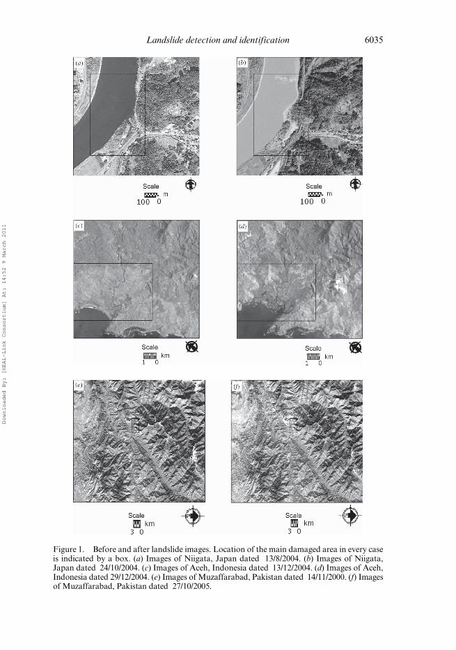
Figure 1. Before and after landslide images. Location of the main damaged area in every caseis indicated by a box. (a) Images of Niigata, Japan dated 13/8/2004. (b) Images of Niigata,Japan dated 24/10/2004. (c) Images of Aceh, Indonesia dated 13/12/2004. (d) Images of Aceh,Indonesia dated 29/12/2004. (e) Images of Muzaffarabad, Pakistan dated 14/11/2000. (f) Imagesof Muzaffarabad, Pakistan dated 27/10/2005.
Landslide detection and identification 6035
Downloaded By: [HEAL-Link Consortium] At: 14:52 9 March 2011

similarity of these pixels will be low. We use mutual information as the measure of
similarity. Point similarity based on mutual information was used by Rogelj et al.
(2003) as a way of measuring similarity when registering two medical images.
Mutual information of the overlapping parts of the two images was computed using:
MAB ¼XpA
XpA
PABðpAi ; p
Bi Þ log10
PABðpAi ; p
Bi Þ
PAðpAÞPBðpBÞ
� �; (1)
where PAðpAÞ is the normalized histogram of grey values of the reference image,PBðpBÞ is the normalized histogram of grey values of the sensed image and
PABðpAi ; p
Bi Þis the normalized joint histogram of the grey values pA
i and pBi which
correspond to the same pixel i. Local mutual information is derived from the global
mutual information. Equation (1) may be rewritten as:
MAB ¼XpA
XpB
Ni
Nlog10
PABðpAi ; p
Bi Þ
PAðpA; pBÞ
� �
¼ 1
N
Xc
log10
PABðpAc ; p
Bc Þ
PAðpA; pBÞ
� �; ð2Þ
where Ni is the number of occurrences of intensity pair ðpAi ; p
Bi Þ and N is the number of
pixels in the overlapping part of the two images. Furthermore, PABðpAc ; p
Bc Þ is the
normalized joint histogram of grey values pAc and pB
c which correspond to the same
coordinate c. Note that the final summation is taken over the spatial image coordinates
instead of the intensities. Therefore, the global similarity MAB can be treated as anaverage of point similarities SMAB
, defined for each pixel at coordinate c:
MAB ¼1
N
Xc
SMAB; (3)
where
SMAB; log10
PABðpAc ; p
Bc Þ
PAðpAÞPBðpBÞ
� �: (4)
We begin by calculating the point similarity of a pixel in every coordinate in the
image. Thus, every pixel c is represented by its value of mutual information. We notethat SMAB
> 0 when PABðpAc ; p
Bc Þ > PAðpAÞPBðpBÞ. This implies that the information
of a pixel at coordinate c in image A can be predicted using the information of the pixel
at coordinate c in image B. Thus, since they are related to each other, point c is defined
as a point with high value of similarity. SMAB¼ 0 when PABðpA
c ; pBc Þ ¼ PAðpAÞPBðpBÞ.
It means that the pixel at coordinate c in image A does not give any information about
the pixel at the same coordinate in image B. They are totally independent. Either pixel
may take any value at all (Petrou 2004). We note that SMAB< 0 when
PABðpAc ; p
Bc Þ < PAðpAÞPBðpBÞ. This means that values pA and pB may have very high
frequencies, but they do not occur together. This is due to a high dissimilarity of the
pixel at coordinate c in images A and B. Thus, based on this definition, we threshold
our local mutual information image as follows:
GðcÞ ¼ 255 if SMAB> 0
0 if SMAB�0
� �; (5)
6036 S. Khairunniza-Bejo et al.
Downloaded By: [HEAL-Link Consortium] At: 14:52 9 March 2011

where G(c) is the binary value of the pixel at coordinate c in the thresholded image.
Therefore, the changed areas are represented by the black pixels in a binary image.
Simple thresholding is not sufficient to identify the true changes. There will be some
undesirable change blobs detected. Therefore, in order to eliminate all undesirable
change blobs, we filtered out these pixels using an area-based filter. We assumed thelandslide to be the largest changed region(s) in the image. To apply it, we first grouped
the connected changed pixels into regions using connected component analysis. The
number of pixels that made up every region was then calculated. The landslide area
was identified as the region or regions with the largest area.
4. Experimental results
Figure 2 shows results of the landslides being detected using the local similaritymeasure method. The binary change image of Niigata is shown in figure 2(a). From
this figure, we can see that the changed locations, which are represented by black
pixels, have very high concentration in the region of the landslide covering the road
along the river. The proposed change detection method is used to detect landslides
with a very large extent. Therefore the threshold value is selected by referring to the
number of pixels in the changed regions. The region or regions with higher numbers of
pixels will be identified as the landslide area. Figure 2(b) shows a histogram of the
changed regions. Regions which contained the number of pixels at the right of thehistogram will be considered as the large region. Therefore, in order to identify the
landslide area, we chose a threshold value of 4000 pixels to the changed regions. As a
result, regions which contained less than 4000 pixels were eliminated. Only two
regions were left. In order to extract these regions properly, we dilated the pixels
inside these regions seven times with a 3 � 3 pixels structuring element. The result is
shown in figure 2(c). The area threshold chosen and the number of dilations per-
formed may appear to be arbitrarily chosen here. However, the choice is made based
on the resolution of the image and the size of the changed regions one seeks to identify.Results of the landslide in Acheh are shown in figure 3. The binary change image of
Aceh is shown in figure 3(a). The area histogram of the regions identified using
connected component analysis is shown in figure 3(b). From this histogram, a thresh-
old value of 1000 pixels was chosen to eliminate the changed regions which contained
less than 1000 pixels. As a result, only two regions were left. Pixels in these regions
were then dilated two times with a 3� 3 pixels structuring element to approximate the
landslide region as shown in panel (c).
Results of the landslide in Muzaffarabad are shown in figure 4. The binary changeimage of Muzaffarabad is shown in figure 4(a). This figure shows that there is a lower
concentration of changed pixels. Thus, it is clearly indicated that both images are
quite similar to each other. The area histogram of the regions identified using
connected component analysis is shown in figure 4(b). From this histogram, a thresh-
old value of 90 pixels was chosen to eliminate the changed regions which contained
less than 90 pixels. The region left is shown in figure 4(c). From this figure, we can see
that the change region was detected at the upper right of the image which is outside the
indicated box. The result shows that this method cannot be used to detect the land-slides in Muzaffarabad. This is because this landslide is too small compared with the
size of the imagery used. To improve the effectiveness of the detection, we decided to
crop the large images and keep only sub-images of size 100 � 100 pixels, 200 � 200
pixels and 300 � 300 pixels which we know contain the landslide, and repeat the
Landslide detection and identification 6037
Downloaded By: [HEAL-Link Consortium] At: 14:52 9 March 2011

process. In all cases, the result showed that the largest identified regions were inside
the boxes indicating the landslide area. These results are shown in figure 5.
Figure 6 shows results of the landslides being detected using the image differencing
method. In the case of landsides in Niigata, it has been shown in figure 6(a) that the
image differencing method detects many changes in the river that are not at the
location along the river where the exact location of the landslides had occurred.
This is because the grey-level values of the pixels before and after the landslide
Figure 2. Landslide in Niigata, Japan. (a) Binary change image produced by thresholding thelocal mutual information of the image. (b) An area histogram of the changed regions. (c) Pixelsin the regions which contain 4000 or more pixels in (a) are dilated seven times with a 3� 3 pixelsstructuring element.
6038 S. Khairunniza-Bejo et al.
Downloaded By: [HEAL-Link Consortium] At: 14:52 9 March 2011

occurrence in this area are not similar. Therefore, although there are no physical
changes, the image differencing method will detect these changes. In the case of
landslides in Pakistan, the image differencing method only can detect the landslides
when the sub-images of size 100 � 100 were used. This is shown in figure 7(a).
From the results, we found that both change detection methods cannot be used to
detect and quantify small landslides when the size of the imagery used is too large
Figure 3. Landslide in Aceh, Indonesia. (a) Binary change image produced by thresholdingthe local mutual information of the image. (b) An area histogram of the changed regions. (c)Pixels in the regions which contain 1000 or more pixels in (a) are dilated two times with a 3� 3pixels structuring element.
Landslide detection and identification 6039
Downloaded By: [HEAL-Link Consortium] At: 14:52 9 March 2011

compared with the landslide areas. Table 1 summarizes the ratio of the approximate
size of the landslide over the size of the imagery used. Since the sizes of landslides fromthe ground truth data were not available, we assumed the size of each landslide to
be the same as the size of the box indicating it. From this table, it can be concluded
that the local similarity measure method works well when the ratio between the
landslide and the imagery used is approximately 1 to a few tens, and that the method
breaks down when this ratio is of the order of 1 to 100. This is because the landslide
has to be small enough for the global mutual information not to be affected by its
0 20 40 60 80 100 1200
2
4
6
8
10
number of pixels
num
ber
of r
egio
ns
(a)
(b)
(c)
km
km
Figure 4. Landslide in Muzaffarabad, Pakistan. (a) Binary change image produced by thresh-olding the local mutual information of the image. (b) The area histogram of the changedregions. (c) Regions which contain 90 or more pixels in (a).
6040 S. Khairunniza-Bejo et al.
Downloaded By: [HEAL-Link Consortium] At: 14:52 9 March 2011

presence (and so the landslide to appear as a significant anomaly), and large enough
for the anomaly created by the landslide to be larger than the normal variation
observed either due to genuine small changes in the image, or due to noise in the
calculation of the statistical quantities. However, the image differencing method does
not give a consistent ratio of the detected landslide area with size of imagery used. Thisis because the image differencing method only depends on the grey-level value of the
image, not global or local information. Results of the detected change areas show that
some mis-detection occurred in both methods. Therefore, the false alarm rate was
Figure 5. Results of the local similarity measure method for the subimages of the landslides inMuzaffarabad, Pakistan. The largest region in the images has been dilated with a 3 � 3 pixelsstructuring element. (a) 100 � 100 pixels size of subimage. One time erosion and one timedilation. (b) 200 � 200 pixels size of subimage. Two time dilation and eight time erosion.(c) 300 � 300 pixels size of subimage. Two time dilation and eight time erosion.
Landslide detection and identification 6041
Downloaded By: [HEAL-Link Consortium] At: 14:52 9 March 2011

Figure 6. Results of the image differencing method. (a) Binary change image of Niigata, Japanproduced by thresholding the difference image with the threshold value of 100. (b) Pixels in theregions which contain 35 000 or more pixels in (a). (c) Binary change image of Aceh, Indonesiaproduced by thresholding the difference image with the threshold value of 50. (d) Pixels in theregions which contain 1600 or more pixels in (c) are dilated two times with a 3 � 3 pixelsstructuring element. Results of the image differencing method. (e) Binary change image ofMuzaffarabad, Pakistan produced by thresholding the difference image with the thresholdvalue of 15. (f) Pixels in the regions which contain 1600 or more pixels in (e).
6042 S. Khairunniza-Bejo et al.
Downloaded By: [HEAL-Link Consortium] At: 14:52 9 March 2011

calculated by dividing the number of false alarms by the number of alarms. It has been
shown that the proposed method gives a smaller false alarm rate of only 16%,
compared to that of the image differencing method, which is 50%. In terms of CPU
time, the local similarity measure method has higher computational cost compared to
the image differencing method. The method took 349 s for the Niigata image, 7 s forthe Aceh image and 2 s for the Muzaffarabad image to complete the whole process of
Figure 7. Results of the image differencing method for the subimages of the landslides inMuzaffarabad, Pakistan. The largest region in the images. (a) 100� 100 pixels size of subimage.The largest region in the image has been dilated one time with a 3� 3 pixels structuring element.(b) 200 � 200 pixels size of subimage. (c) 300 � 300 pixels size of subimage.
Landslide detection and identification 6043
Downloaded By: [HEAL-Link Consortium] At: 14:52 9 March 2011

detection and identification. Meanwhile, the image differencing method took only 1 s
for the Niigata image and , 1 s for the Aceh and Muzaffarabad images.
5. Conclusions
In this article we presented a simple method of change detection and identificationusing a local similarity measure based on mutual information and image thresholding.
It has been shown that the local similarity measure method gives more reliable results
of detection and identification compared to the image differencing method. Since
mutual information is used as a measure of similarity, this method can be used to
detect landslides even from different modality images. We demonstrated that this
method can be used to detect changes in natural and remote areas. The area-based
filter can be used to identify the most significant changed areas. Therefore, this
method is suitable for detecting extensive landslides, where the area covered by thelandslide region is also identified as the largest area among the other changed regions.
The use of mathematical morphology gave a good approximation of the area where
the landslide had occurred. The algorithm for detecting the changed pixels can be fully
automatic. Post-processing for identifying coherent changed regions, however,
requires the choice of thresholds and this is semi-automatic. This part may also be
automated if prior knowledge about the scale of the image and the size of the expected
landslide is considered. The method is superior to the simplest method of change
detection. However, the method does not include a mechanism that allows thedistinction between a landslide and any other change on the surface of the Earth
that causes changes in the appearance of the image. Such a mechanism should
probably involve a higher level of knowledge which includes the slope and shape
information and it should probably operate in conjunction with an expert system.
Since the capability of the proposed method depends on the ratio of the unchanged to
changed pixels in the image, this semi-automatic method has the potential to detect
small size landslides in high spatial resolution satellite images if the ratio between the
unchanged to changed pixels in the image is in the order of one to a few tens. Withfurther in-depth study of this method, it could have the potential to be used to classify
landslide zones, such as zone of initiation, zone of transportation and zone of
accumulation.
ReferencesCHENG, K.S., WEI, C. and CHANG, S.C., 2004, Locating landslides using multi-temporal satellite
images. Advances in Space Research, 33, pp. 296–301.
Table 1. Comparison on the ratio of the approximation of the landslide area with size ofimagery used.
CaseImage size
(pixel)Box size(pixel) Ratio
Local similaritymeasure
Imagedifferencing
Niigata 1033 �1044 450 � 720 1:33.33p �
Aceh 270 � 270 170 � 130 1:32.99 p pMuzaffarabad 565 � 768 40 � 65 1:166.89 � �Sub-image 1 100 � 100 40 � 65 1:3.85
p pSub-image 2 200 � 200 40 � 65 1:15.38 p �Sub-image 3 300 � 300 40 � 65 1:34.62 p �
6044 S. Khairunniza-Bejo et al.
Downloaded By: [HEAL-Link Consortium] At: 14:52 9 March 2011

HERVAS, J., BARREDO, J.I., ROSIN, P.L., PASUTO, A., MANTOVANI, F. and SILVANO, S., 2003,
Monitoring landslides from optical remotely sensed imagery: the case history of Tessina
landslide, Italy. Geomorphology, 1346, pp. 1–13.
LIN, W.T., CHOU, W.C., LIN, C.Y., HUANG, P.H. and TSAI, J.S., 2005, Vegetation recovery
monitoring and assessment at landslides caused by earthquake in Central Taiwan.
Forest Ecology and Management, 210, pp. 55–66.
NICHOL, J. and WONG, M.S., 2005a, Satellite remote sensing for detailed landslide inventories
using change detection and image fusion. International Journal of Remote Sensing, 9,
pp. 1913–1926.
NICHOL, J. and WONG M.S., 2005b, Detection and interpretation of landslides using satellite
images. Land Degradation and Development, 16, pp. 243–255.
OSTIR, K., VELJANOVSKI, T., PODOBNIKAR, T. and STANCIC, Z., 2003, Application of satellite
remote sensing in natural hazard management: the Mount Mangart landslide case
study. International Journal of Remote Sensing, 24, pp. 3983–4002.
PETROU, M., 2004, Image Registration: an overview. Advances in Imaging and Electron Physics,
130, pp. 243–291.
ROGELJ, P. and KOVACIC, S., 2003, Point similarity measure based on mutual information. In 2nd
International Workshop on Biomedical Image Registration, 23–24 June, 2003, Philadelphia,
USA, pp. 112–121 (New York: Springer-Verlag).
ROGELJ, P., KOVACIC, S. and GEE, J.C., 2003, Point similarity measures for non-rigid registra-
tion of multi-modal data. Computer Vision and Image Understanding, 92, pp. 112–140.
ROSIN, P.L. and HERVAS, J., 2005, Remote sensing image thresholding methods for determining
landslide activity. International Journal of Remote Sensing, 26, pp. 1075–1092.
WHITWORTH, M.C.Z., GILES, D.P. and MURPHY, W., 2005, Airbone remote sensing for landslide
hazard assessment: a case study on the Jurassic escarpment slopes of Worcestershire,
UK. The Quarterly Journal of Engineering Geology and Hydrogeology, 38, pp. 197–213.
YAMAGUCHI, Y., TANAKA, S., ODAJIMA, T., KAMAI, T. and TSUCHIDA, S., 2003, Detection of a
landslide movement as geometric misregistration in image matching of SPOT HRV
data of two different dates. International Journal of Remote Sensing, 24, pp. 3523–3534.
Landslide detection and identification 6045
Downloaded By: [HEAL-Link Consortium] At: 14:52 9 March 2011


![User profile correlation-based similarity (UPCSim) algorithm ......collaborative ltering similarity [29], the Triangle Multiplying Jaccard (TMJ) similarity [30], and the similarity](https://img.pdfslide.us/doc/110x75/6147013af4263007b1358a2c/user-profile-correlation-based-similarity-upcsim-algorithm-collaborative.jpg)


![Pal_et_al[1] SAR FFT Lineament IJRS](https://img.pdfslide.us/doc/110x75/577d205d1a28ab4e1e92a9c1/paletal1-sar-fft-lineament-ijrs.jpg)