Embed Size (px)
Citation preview

International Conservation Designation
Special Protection Areas
Bowland Fells SPA
1. The Bowland Fells SPA was first classified by the UK government as an SPA under the provisions of the Birds Directive in 1993.
2. The SPA covers 16,002.31 ha in the county of Lancashire 3. The SPA qualifies under Article 4.1 of the Birds Directive as it is used regularly by 1% or more
of the Great Britain populations of the following species listed on Annex I: During breeding season: Hen Harrier, Circus cyaneus Merlin, Falco columbarius
4. The SPA also qualifies under Article 4.2 of the Directive as it is used regularly by 1% or more
of the biogeographical population of the following regularly occurring migratory species: During breeding season: Lesser Black‐backed Gull, Larus fuscus
5. The Bowland Fells SPA departmental brief, designation citation and conservation objective summary are currently being updated. The boundary map is included in Annex...
6. The proposed offshore wind farm is located outside of the SPA.
Dee Estuary SPA
7. The Dee Estuary SPA was first classified by the UK government as an SPA under the provisions of the Birds Directive in 1985, covering an area of 13,065.8 ha. The current area of the SPA was classified in 2009.
8. The SPA covers 14,291.56 ha in the counties of Cheshire, Denbighshire and Flintshire. 9. The SPA qualifies under Article 4.1 of the Birds Directive as it is used regularly by 1% or more
of the Great Britain populations of the following species listed on Annex I: During breeding season: Common Tern, Sterna hirundo Little Tern, Sterna albifrons On passage: Sandwich Tern, Sterna sandvicensis Over winter: Bar‐tailed Godwit, Limosa lapponica
10. The SPA also qualifies under Article 4.2 of the Directive as it is used regularly by 1% or more of the biogeographical population of the following regularly occurring migratory species:
On passage: Redshank, Tringa totanus Over winter: Black‐tailed Godwit, Limosa limosa islandica Curlew, Numenius arquata
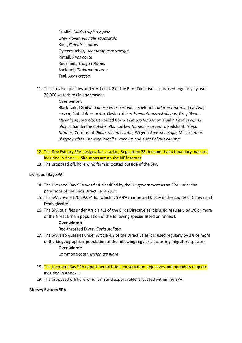
Dunlin, Calidris alpina alpina Grey Plover, Pluvialis squatarola Knot, Calidris canutus Oystercatcher, Haematopus ostralegus Pintail, Anas acuta Redshank, Tringa totanus Shelduck, Tadorna tadorna Teal, Anas crecca
11. The site also qualifies under Article 4.2 of the Birds Directive as it is used regularly by over 20,000 waterbirds in any season:
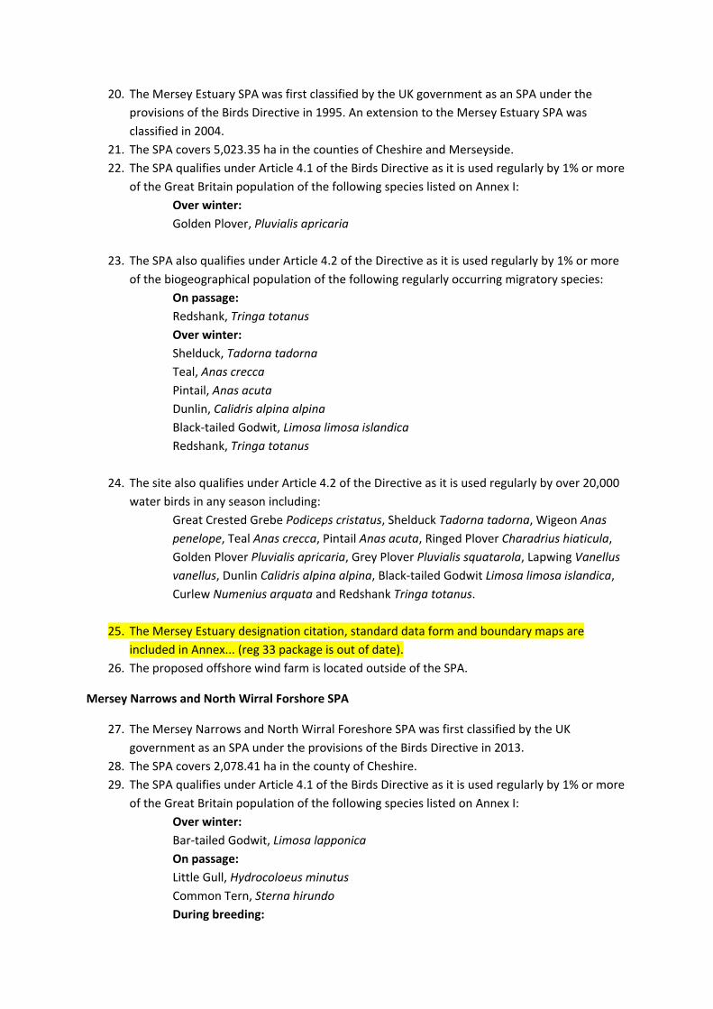
Over winter: Black‐tailed Godwit Limosa limosa islandic, Shelduck Tadorna tadorna, Teal Anas crecca, Pintail Anas acuta, Oystercatcher Haematopus ostralegus, Grey Plover Pluvialis squatarola, Bar‐tailed Godwit Limosa lapponica, Dunlin Calidris alpina alpina, Sanderling Calidris alba, Curlew Numenius arquata, Redshank Tringa totanus, Cormorant Phalacrocorax carbo, Wigeon Anas penelope, Mallard Anas platyrhynchos, Lapwing Vanellus vanellus and Knot Calidris canutus
12. The Dee Estuary SPA designation citation, Regulation 33 document and boundary map are included in Annex... Site maps are on the NE internet
13. The proposed offshore wind farm is located outside of the SPA.
Liverpool Bay SPA
14. The Liverpool Bay SPA was first classified by the UK government as an SPA under the provisions of the Birds Directive in 2010.
15. The SPA covers 170,292.94 ha, which is 99.9% marine and 0.01% in the county of Conwy and Denbighshire.
16. The SPA qualifies under Article 4.1 of the Birds Directive as it is used regularly by 1% or more of the Great Britain population of the following species listed on Annex I:
Over winter: Red‐throated Diver, Gavia stellata
17. The SPA also qualifies under Article 4.2 of the Directive as it is used regularly by 1% or more of the biogeographical population of the following regularly occurring migratory species:
Over winter: Common Scoter, Melanitta nigra
18. The Liverpool Bay SPA departmental brief, conservation objectives and boundary map are included in Annex...
19. The proposed offshore wind farm and export cable is located within the SPA
Mersey Estuary SPA
20. The Mersey Estuary SPA was first classified by the UK government as an SPA under the provisions of the Birds Directive in 1995. An extension to the Mersey Estuary SPA was classified in 2004.
21. The SPA covers 5,023.35 ha in the counties of Cheshire and Merseyside. 22. The SPA qualifies under Article 4.1 of the Birds Directive as it is used regularly by 1% or more
of the Great Britain population of the following species listed on Annex I: Over winter: Golden Plover, Pluvialis apricaria
23. The SPA also qualifies under Article 4.2 of the Directive as it is used regularly by 1% or more of the biogeographical population of the following regularly occurring migratory species:
On passage: Redshank, Tringa totanus Over winter: Shelduck, Tadorna tadorna Teal, Anas crecca Pintail, Anas acuta Dunlin, Calidris alpina alpina Black‐tailed Godwit, Limosa limosa islandica Redshank, Tringa totanus
24. The site also qualifies under Article 4.2 of the Directive as it is used regularly by over 20,000 water birds in any season including:
Great Crested Grebe Podiceps cristatus, Shelduck Tadorna tadorna, Wigeon Anas penelope, Teal Anas crecca, Pintail Anas acuta, Ringed Plover Charadrius hiaticula, Golden Plover Pluvialis apricaria, Grey Plover Pluvialis squatarola, Lapwing Vanellus vanellus, Dunlin Calidris alpina alpina, Black‐tailed Godwit Limosa limosa islandica, Curlew Numenius arquata and Redshank Tringa totanus.
25. The Mersey Estuary designation citation, standard data form and boundary maps are included in Annex... (reg 33 package is out of date).
26. The proposed offshore wind farm is located outside of the SPA.
Mersey Narrows and North Wirral Forshore SPA
27. The Mersey Narrows and North Wirral Foreshore SPA was first classified by the UK government as an SPA under the provisions of the Birds Directive in 2013.
28. The SPA covers 2,078.41 ha in the county of Cheshire. 29. The SPA qualifies under Article 4.1 of the Birds Directive as it is used regularly by 1% or more
of the Great Britain population of the following species listed on Annex I: Over winter: Bar‐tailed Godwit, Limosa lapponica On passage: Little Gull, Hydrocoloeus minutus Common Tern, Sterna hirundo During breeding:
Common tern, Sterna hirundo
30. The SPA also qualifies under Article 4.2 of the Directive as it is used regularly by 1% or more of the biogeographical population of the following regularly occurring migratory species:
Overwinter: Knot, Calidris canutus
31. The site also qualifies under Article 4.2 of the Directive as it is used regularly by over 20,000 water birds in any season including:
Cormorant Phalacrocorax carbo, Oystercatcher Haematopus ostralegus, Grey Plover Pluvialis squatarola, Sanderling Calidris alba, Knot Calidris canutus, Dunlin Calidris alpina alpina, Bar‐tailed Godwit Limosa lapponica and Redshank Tringa totanus
32. The Mersey Narrows and North Wirral Foreshore SPA designation citation and standard data form are included in Annex...
33. The proposed offshore wind farm is located outside of the SPA.
Morecambe Bay SPA
34. The Morecambe Bay SPA was first classified by the UK government as an SPA under the provisions of the Birds Directive in 1996.
35. The SPA covers 37,404.6 ha in the counties of Lancashire and Cumbria. 36. The SPA qualifies under Article 4.1 of the Birds Directive as it is used regularly by 1% or more
of the Great Britain population of the following species listed on Annex I: During breeding: Sandwich Tern, Sterna sandvicensis
37. The SPA also qualifies under Article 4.2 of the Directive as it is used regularly by 1% or more of the biogeographical population of the following regularly occurring migratory species:
Over winter: Pink‐footed Goose, Anser brachyrhynchus Shelduck, Tadorna tadorna Pintail, Anas acuta Oystercatcher, Haematopus ostralegus Grey Plover, Pluvialis squatarola Knot, Calidris canutus Dunlin, Calidris alpina alpina Bar‐tailed Godwit, Limosa lapponica Curlew, Numenius arquata Redshank, Tringa totanus Turnstone, Arenaria interpres On passage: Ringed Plover, Charadrius hiaticula
38. The site also qualifies under Article 4.2 of the Directive as it is used regularly by over 20,000 water birds in any season including:
Sandwich Tern Sterna sandvicensis, Pink‐footed Goose Anser brachyrhynchus, Shelduck Tadorna tadorna, Pintail Anas acuta, Oystercatcher Haematopus ostralegus, Grey Plover Pluvialis squatarola, Knot Calidris canutus, Dunlin Calidris alpina alpina, Bar‐tailed Godwit Limosa lapponica, Curlew Numenius arquata, Redshank Tringa totanus, and Turnstone Arenaria interpres
39. The Morecambe Bay SPA Regulation 33, standard data form and boundary map are included in Annex...
40. The proposed offshore wind farm is located outside of the SPA.
Ribble and Alt Estuaries SPA
41. The Ribble and Alt Estuary SPA was first classified by UK government as an SPA under the provisions of the Birds Directive in 1995.
42. The SPA covers 12,421.31 ha in the counties of Merseyside and Lancashire. 43. The SPA qualifies under Article 4.1 of the Birds Directive as it is used regularly by 1% or more
of the Great Britain population of the following species listed on Annex I: Over winter Golden Plover, Pluvialis apricaria Bewicks Swan, Cygnus columbianus bewickii Whooper Swan, Cygnus cygnus Bar‐tailed Godwit, Limosa lapponica
44. The SPA also qualifies under Article 4.2 of the Directive as it is used regularly by 1% or more of the biogeographical population of the following regularly occurring migratory species:
Over winter Pink‐footed Goose, Anser brachyrhynchus Shelduck, Tadorna tadorna Wigeon, Anas penelope Teal, Anas crecca Pintail, Anas acuta Oystercatcher, Haematopus ostralegus Grey Plover, Pluvialis squatarola Knot, Calidris canutus Dunlin, Calidris alpina Black‐tailed godwit, Limosa limosa Redshank, Tringa totanus On passage Redshank, Tringa totanus Sanderling, Calidris alba
45. The site also qualifies under Article 4.2 of the Directive as it is used regularly by over 20,000 water birds in any season including:
Black‐headed Gull Larus ridibundus , Lesser Black‐backed Gull Larus fuscus, Common Tern Sterna hirundo, Cormorant Phalacrocorax carbo, Bewick’s Swan Cygnus columbianus bewickii, Whooper Swan Cygnus cygnus, Pink‐footed Goose Anser
brachyrhynchus, Shelduck Tadorna tadorna, Wigeon Anas penelope, Teal Anas crecca, Pintail Anas acuta, Greater Scaup Aythya marila, Common Scoter Melanitta nigra, Oystercatcher Haematopus ostralegus, Ringed Plover Charadrius hiaticula, Golden Plover Pluvialis apricaria, Grey Plover Pluvialis squatarola , Northern Lapwing Vanellus vanellus, Knot Calidris canutus, Sanderling Calidris alba, Dunlin Calidris alpina alpina, Black‐tailed Godwit Limosa limosa islandica, Bar‐tailed Godwit Limosa lapponica, Curlew Numenius arquata, Redshank Tringa totanus.
46. The Ribble and Alt Estuary SPA Regulation 33, Standard Data Form and boundary map are included in Annex...
47. The proposed offshore wind farm is located outside of the SPA.
Upper Solway Flats and Marshes SPA
48. The Solway Firth SPA was first classified by UK government as an SPA under the provisions of the Birds Directive in 1992.
49. The SPA covers 43,636.73 ha in the counties of Cumbria and Dumfries and Galloway. 50. The SPA qualifies under Article 4.1 of the Birds Directive as it is used regularly by 1% or more
of the Great Britain population of the following species listed on Annex I: Over winter Barnacle Goose, Branta leucopsis Whooper Swan, Cygnus cygnus Golden Plover, Pluvialis squatarola Bar‐tailed Godwit, Limosa lapponica
51. The SPA also qualifies under Article 4.2 of the Directive as it is used regularly by 1% or more of the biogeographical population of the following regularly occurring migratory species:
Over winter Pink‐footed Goose, Anser brachyrhynchus Oystercatcher, Haematopus ostralegus Knot, Calidris canutus Curlew, Numenius arquata Pintail, Anas acuta Redshank, Tringa totanus Greater Scaup, Aythya marila Ringed Plover, Charadrius hiaticula
52. The site also qualifies under Article 4.2 of the Directive as it is used regularly by over 20,000 water birds in any season including:
Whooper Swan Cygnus cygnus, Pink‐footed Goose Anser brachyrhynchus, Barnacle Goose Branta leucopsis, Shelduck Tadorna tadorna, Teal Anas crecca, Pintail Anas acuta, Northern Shoveler Anas clypeata, Greater Scaup Aythya marila, Common Goldeneye Bucephala clangula, Oystercatcher Haematopus ostralegus, Golden Plover Pluvialis apricaria, Grey Plover Pluvialis squatarola, Knot Calidris canutus, Sanderling Calidris alba, Dunlin Calidris alpina alpina, Bar‐tailed Godwit Limosa
lapponica, Curlew Numenius arquata, Redshank Tringa totanus, Turnstone Arenaria interpres.
53. The Upper Solway Flats and Marshses SPA Regulation 33, Standard Data Form and boundary map are included in Annex...
54. The proposed wind farm is located outside of the SPA.
Ramsar Sites
Dee Estuary
55. The Dee Estuary Ramsar was first classified by the UK government as a Ramsar under the provisions of the Ramsar Convention in 1985. The boundaries and site features were revised in 2009.
56. The Ramsar covers 14,303.02 ha along the counties of Cheshire, Denbighshire and Cheshire. 57. The site qualifies under the following criteria:
Criterion 1: the site contains a representative, rare, or unique example of a natural or near‐natural wetland type found within the appropriate biogeographical region Criterion 2: the site supports vulnerable, endangered, or critically endangered species or threatened ecological communities Criterion 5: the site regularly supports 20,000 or more waterbirds Criterion 6: the sire regularly supports 1% of the individuals in the populations of the following species or subspecies of waterbird in any season: Redshank, Tringa totanus Shelduck, Tadorna tadorna Teal, Anas crecca Pintail, Anas acuta Oystercatcher, Haematopus ostralegus Grey Plover, Pluvialis squatarola Knot, Calidris canutus islandica Dunlin, Calidris alpina Black‐tailed Godwit, Limosa limosa islandica Bar‐tailed Godwit, Limosa lapponica Curlew, Numenius arquata Redshank, Tringa totanus
58. The Dee Estuary Ramsar citation and Regulation 33 documents are included in Annex... 59. The proposed offshore wind farm is located outside the Ramsar.
Morecambe Bay
60. The Morecambe Bay Ramsar was classified by the UK government as a Ramsar under the provisions of the Ramsar Convention in 1996.
61. The Ramsar covers 37,404.6 ha in the counties of Cumbria and Lancashire. 62. The site qualifies under the following criteria:
Criterion 4: The site is a staging area for migratory wildfowl including internationally important numbers of passage Ringed Plover, Charadrius hiaticula.
Criterion 5: the site regularly supports 20,000 or more waterbirds Criterion 6: species/populations occurring at levels of international importance Qualifying species/populations: Species regularly supported during the breeding season: Lesser Black‐backed Gull, Larus fuscus Herring Gull, Larus argentatus Sandwich Tern, Sterna sandvicensis Species with peak counts in spring/autumn: Great Cormorant, Phalacrocorax carbo Common Shelduck, Tadorna tadorna Northern Pintail, Anas acuta Common Eider, Somateria mollissima Eurasian Oystercatcher, Haematopus ostralegus Ringed Plover, Charadrius hiaticula
Grey Plover, Pluvialis squatarola Sanderling, Calidris alba Eurasian Curlew, Numenius arquata Common Redshank, Tringa totanus Ruddy Turnstone, Arenaria interpres Lesser Black‐backed Gull, Larus fuscus Species with peak counts in winter: Great Crested Grebe, Podiceps cristatus Pink‐footed Goose, Anser brachyrhynchus Eurasian Wigeon, Anas penelope Common Goldeneye, Bucephala clangula Red‐breasted Merganser, Merus serrator Golden Plover, Pluvialis apricaria Northern Lapwing, Vanellus vanellus Knot, Calidris canutus Dunlin, Calidris alpina Bar‐tailed Godwit, Limosa lapponica
63. The Morecambe Bay Ramsar Information Sheet is included in Annex... 64. The proposed offshore wind farm is located outside of the Ramsar.
Sites of Special Scientific Interest
Bowland Fells SSSI
65. The Bowland Fells SSSI was classified by the UK government as a SSSI under the provisions of the Wildlife and Countryside Act 1981 in 1988.
66. The SSSI covers 16,007.64 ha in the county of Lancashire 67. The site has been notified for:
Upland moorland and grassland with water bodies Aggregations of breeding birds: Hen Harrier, Circus cyaneus
Lesser Black‐backed Gull, Larus fuscus Merlin, Faclo columbarius Vascular plant assemblage
68. The Bowland Fells SSSI site information can be found here: http://tenis:8008/special/sssi/SSSIhome.cfm?frmid=1005542&sssi_id=1005542&frmvalue=
69. The proposed offshore wind farm is located outside of the SSSI.
Dee Estuary SSSI
70. The Dee Estuary SSSI was classified by UK government as a SSSI under the provisions of the Wildlife and Countryside Act in 1998.
71. The site covers 6,320.18 ha in the counties of Merseyside and Cheshire. 72. The site has been notified for:
Aggregations of breeding birds: Common Tern, Sterna hirundo Redshank, Tringa totanus Aggregations of non‐breeding birds: Bar‐tailed Godwit, Limosa lapponica Black‐tailed Godwit, Limosa limosa Cormorant, Phalacrocorax carbo Curlew, Numenius arquata Dunlin, Calidris alpina Great Crested Grebe, Podiceps cristatus Grey Plover, Pluvialis squatarola Knot, Calidris canutus Oystercatcher, Haematopus ostralegus Pintail, Anas acuta Redshank, Tringa totanus Ringed Plover, Charadrius hiaticula Shelduck, Tadorna tadorna Teal, Anas crecca Wigeon, Anas penelope Estuaries Sheltered muddy shores (including estuarine muds) Wave exposed sandy shores (with burrowing crustaceans and polychaetes) Hard rocky sandstone cliffs of Hilbre Island and Middle Eye with their cliff vegetation and maritime heathland and grassland; its assemblage of nationally scarce plants; and its populations of Sandhill Rustic Moth
73. The Dee Estuary SSSI site information can be found here: http://tenis:8008/special/sssi/SSSIhome.cfm?frmid=1000595&sssi_id=1000595&frmvalue=
74. The proposed offshore wind farm is located outside of the SSSI.
Duddon Estuary SSSI
75. The Duddon Estuary SSSI was classified by UK government as a SSSI under the provisions of the Wildlife and Countryside Act in 1991.
76. The site covers 6,786.02 ha in the county of Cumbria. 77. The site has been notified for:
Aggregations of more than 20,000 non‐breeding waterbirds Aggregations of breeding birds: Sandwich Tern, Sterna sandvicensis Aggregations of non‐breeding birds: Curlew, Numenius arquata Dunlin, Calidris alpine Knot, Calidris canutus Oystercatcher, Haematopus ostralegus Pintail, Anas acuta Red‐breasted Merganser, Mergus serrator Redshank, Tringa tetanus Ringed Plover, Charadrius hiaticula Sanderling, Calidris alba Shelduck, Tadorna tadorna Assemblages of breeding birds – Sand dunes and saltmarshes Natterjack Toad, Budo calamita Saline coastal lagoons Sheltered muddy shores (including estuarine muds) Invertebrate assemblage Vascular plant assemblage
78. The Duddon Estuary SSSI site information can be found here: http://tenis:8008/special/sssi/SSSIhome.cfm?frmid=1000104&sssi_id=1000104&frmvalue=
79. The proposed offshore wind farm is located outside of the SSSI.
Lune Estuary SSSI
80. The Lune Estuary SSSI was classified by UK government as a SSSI under the provisions of the Wildlife and Countryside Act in 1990.
81. The site covers 7,633.24 ha in the county of Lancashire. 82. The site is notified for:
Aggregations of breeding birds: Common Tern, Sterna hirundo Aggegations of non‐breeding birds: Black‐tailed Godwit, Limosa limosa Curlew, Numenius arquata Dunlin, Calidris alpina Grey Plover, Pluvialis squatarola Knot, Calidris canutus Oystercatcher, Haematopus ostralegus Pink‐footed Goose, Anser brachyrhynchus Redshank, Tringa totanus

Ringed Plover, Charadrius hiaticula Sanderling, Calidris alba Turnstone, Arenaria interpres Assemblages of breeding birds – Sand‐dunes and saltmarshes Sheltered muddy shores (including estuarine muds) Wave exposed sandy shores (with burrowing crustaceans and polychaetes) Vascular plant assemblage
83. The Lune Estuary SSSI site information can be found here: http://tenis:8008/special/sssi/SSSIhome.cfm?frmid=1001709&sssi_id=1001709&frmvalue=
84. The proposed offshore wind farm is located outside of the SSSI.
Mersey Narrows SSSI
85. The Mersey Narrows SSSI was classified by UK government as a SSSI under the Wildlife and Countryside Act in 2000
86. The site covers 116.34 ha in the county of Merseyside 87. The site has been notified for:
Aggregations of non‐breeding birds: Cormorant, Phalacrocorax carbo Redshank, Tringa totanus Turnstone, Arenaria interpres Isolated saline lagoons Moderately exposed sandy shores (with polychaetes and bivalves) Sheltered muddy shores (including estuarine muds) SM9 – Suaeda maritima Saltmarsh
88. The Mersey Narrows SSSI site information can be found here: http://tenis:8008/special/sssi/SSSIhome.cfm?frmid=2000436&sssi_id=2000436&frmvalue=
89. The proposed offshore wind farm is located outside of the SSSI.
North Wirral Foreshore SSSI
90. The North Wirral Foreshore SSSI was classified by the UK government as a SSSI under the Wildlife and Countryside Act in 1983.
91. The site covers 1,962.29 ha in the county of Merseyside. 92. The site has been notified for:
Aggregations of non‐breeding birds: Bar‐tailed Godwit, Limosa lapponica Dunlin, Calidris alpina Knot, Calidris canutus Turnstone, Arenaria interpres Sheltered muddy shores (including estuarine muds) Wave exposed sandy shores (with burrowing crustaceans and polychaetes) SM10 – Transitional low marsh vegetation with Puccinellia maritima, annual Salicornia species and Suaeda maritima
SM6 – Spartina anglica Saltmarsh
93. The North Wirral Foreshore SSSI site information can be found here: http://tenis:8008/special/sssi/SSSIhome.cfm?frmid=1003676&sssi_id=1003676&frmvalue=
94. The proposed offshore wind farm is located outside of the SSSI.
Ribble Estuary SSSI
95. The Ribble Estuary SSSI was classified by UK government as a SSSI under the provisions of the Wildlife and Countryside Act in 1984.
96. The site covers 9,348.45 ha in the counties of Lancashire and Merseyside. 97. The site has been notified for:
Aggregations of more than 20,000 non‐breeding waterbirds Aggregations of breeding birds Black‐headed Gull, Larus ridibundus Common Tern, Sterna hirundo Redshank, Tringa totanus Aggregations of non‐breeding birds: Bar‐tailed Godwit, Limosa lapponica Bewick’s Swan, Cugnus columbianus bewickii Black‐tailed Godwit, Limosa limosa Dunlin, Calidris alpina Golden Plover, Pluvialis apricaria Knot, Calidris canutus Oystercatcher, Haematopus ostralegus Pink‐footed Goose, Anser brachyrhynchus Sanderling, Calidris alba Shelduck, Tadorna tadorna Wigeon, Anas penelope Assemblages of breeding birds – mixed Sheltered muddy shores (including estuarine muds)
98. The Ribble Estuary SSSI site information can be found here: http://tenis:8008/special/sssi/SSSIhome.cfm?frmid=1004299&sssi_id=1004299&frmvalue=
99. The proposed offshore windfarm is located outside the SSSI.
River Dee SSSI
100. The River Dee SSSI was classified by UK government as a SSSI under the provisions of the Wildlife and Countryside Act in 2002.
101. The site covers 371.46 ha in the counties of Cheshire and Shropshire. 102. The site has been notified for:
Atlantic Salmon, Salmo salar Otter, Lutra lutra Flowing waters – Type VI: base‐rich, mesotrophic rivers in western and northern Britain, with a moderate to fast current

Nationally rare and scarce dragonfly species – Gomphus vulgatisimus, Club‐tailed Dragonfly IA – Fluvial Geomorphology
103. The River Dee SSSI site information can be found here: http://tenis:8008/special/sssi/SSSIhome.cfm?frmid=2000452&sssi_id=2000452&frmvalue=
104. The proposed offshore wind farm is located outside the SSSI.
Sefton Coast SSSI
105. The Sefton Coast SSSI was classified by the UK government as a SSSI under the provisions of the Wildlife and Countryside Act in 2000.
106. The site covers 4,634.05 ha in the county of Merseyside. 107. The site has been notified for:
Aggregations of non‐breeding birds: Bar‐tailed Godwit, Limosa lapponica Dunlin, Calidris alpine Grey Plover, Pluvialis squatarola Knot, Calidris canutus Oystercatcher, Haematopus ostralegus Ringed Plover, Charadrius hiaticula Sanderling, Calidris alba Vascular plant assemblage Grassland, Dune communities, dune‐slack community, strandline community and sandmarsh
108. The Sefton Coast SSSI site information can be found here: http://tenis:8008/special/sssi/SSSIhome.cfm?frmid=2000426&sssi_id=2000426&frmvalue=
109. The proposed offshore wind farm is located outside the SSSI.
South Walney and Piel Channel Flats SSSI
110. The South Walney and Piel Channel Flats SSSI was classified by UK government as a SSSI under the provisions of the Wildlife and Countryside Act in 1997.
111. The site covers 2,329.86 ha in the county of Cumbria.
112. The site has been notified for: Aggregations of more than 20,000 non‐breeding waterbirds Aggregations of breeding birds: Arctic Tern, Sterna paradisaea Eider, Somateria mollissima Herring Gull, Larus argentatus Lesser Black‐backed Gull, Larus fuscus Sandwich Tern, Sterna sandvicensis Aggregations of non‐breeding birds:
Cormorant, Phalacrocorax carbo Curlew, Numenius arquata Dunlin, Calidris alpina Eider, Somateria mollissima Grey Plover, Pluvialis squatarola Herring Gull, Larus argentatus Knot, Calidris canutus Lesser Black‐backed Gull, Larus fuscus Oystercatcher, Haematopus ostralegus Redshank, Tringa totanus Shelduck, Tadorna tadorna Invertebrate assemblage Reefs Saline coastal lagoons Sheltered muddy shores (including estuarine muds) Wave exposed sandy shores (with burrowing crustaceans and polychaetes) Vascular plant assemblage
113. The South Walney and Piel Channel Flats SSSI site information can be found here: http://tenis:8008/special/sssi/SSSIhome.cfm?frmid=1002022&sssi_id=1002022&frmvalue=
114. The proposed offshore wind farm is located outside the SSSI.
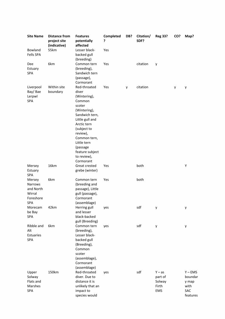
Site Name Distance from project site (indicative)
Features potentially affected
Completed?
DB? Citation/SDF?
Reg 33? CO? Map?
Bowland Fells SPA
55km Lesser black‐backed gull (breeding)
Yes
Dee Estuary SPA
6km Common tern (breeding), Sandwich tern (passage), Cormorant
Yes citation y
Liverpool Bay/ Bae Lerpwl SPA
Within site boundary
Red‐throated diver (Wintering), Common scoter (Wintering), Sandwich tern, Little gull and Arctic tern (subject to review), Common tern, Little tern (passage feature subject to review), Cormorant
Yes y citation y y
Mersey Estuary SPA
16km Great crested grebe (winter)
Yes both Y
Mersey Narrows and North Wirral Foreshore SPA
6km Common tern (breeding and passage), Little gull (passage), Cormorant (assemblage)
Yes both
Morecambe Bay SPA
42km Herring gull and lesser black‐backed gull (Breeding)
yes sdf y y
Ribble and Alt Estuaries SPA
6km Common tern (breeding), Lesser black‐backed gull (Breeding), Common scoter (assemblage), Cormorant (assemblage)
yes sdf y y
Upper Solway Flats and Marshes SPA
150km Red‐throated diver. Due to distance it is unlikely that an impact to species would
yes sdf Y – as part of Solway Firth EMS
Y – EMS boundary map with SAC features
SACs
Site Name
Distance from project site (indicative)
Features potentially affected
Completed? DB? Citation/sdf?
Reg 33?
Co? Map?
Dee Estuary SAC
6km Annex II River Lamprey and Sea Lamprey Annex I mudflats and sand flats covered by seawater at low tide; Salicornia and other annuals colonising mud and sand; estuaries; annual vegetation of cliff lines; vegetated sea cliffs of the Atlantic and Baltic coasts, Annex I embryonic shifting dunes; shifting dunes along the shoreline with Ammomphilia; fixed dunes with herbaceous vegetation.
River Dee and Bala Lake SAC
8.5km Annex II Atlantic salmon; River Lamprey and Sea Lamprey. Annex I mudflats and sand flats covered by seawater at low tide; Salicornia and other annuals colonising mud and sand; estuaries; annual vegetation of cliff lines; vegetated sea cliffs of the Atlantic and Baltic coasts.
Sefton Coast SAC
9km Annex I embryonic shifting dunes; shifting dunes along the shoreline with Ammomphilia; fixed dunes with herbaceous vegetation; dunes with Salix repens ssp.argentea; humid dune slacks; Atlantic decalcified dunes.
Shell Flat and Lune Deep SAC
38km Annex I sandbanks which are slightly covered by sea water all the time and reefs (due to distance from site would
occur)
not have a direct effect through site development however should be considered when planning navigational routes to ports).
Ramsar Sites
Dee Estuary Ramsar 6km Common Tern (Breeding), Little Tern (Breeding), Sandwich Tern (Passage), Cormorant
Morecambe Bay 42km Internationally important numbers of breeding
SSSIs
Site Name Distance from project site (indicative)
Notified features/ Impact Concerns
Bowland Fells SSSI 56km Lesser black‐backed gulls (Aggregations of breeding birds)
Dee Estuary SSSI 6km Common tern (Aggregations of breeding birds), Cormorant (Aggregations of non‐breeding birds). Impact on sediment supplies
Duddon Estuary SSSI 68km Sandwich tern (Aggregations of breeding birds)
Lune Estuary SSSI 49km Common tern (Aggregations of breeding birds)
Mersey Narrows SSSI 7km Cormorant (Aggregations of non‐breeding birds)
North Wirral Foreshore SSSI 7km Impact on sediment supplies Ribble Estuary SSSI 6km Common tern (Aggregations of
breeding birds), Black‐headed gull (Aggregations of breeding birds), Lesser black‐backed gull; Sea bird assemblage
River Dee SSSI 8.5km Atlantic Salmon Sefton Coast SSSI 6km Impact on sediment supplies South Walney and Piel Channel Flats SSSI
64km Arctic tern; Herring Gulls; Lesser Black‐Backed Gulls and Sandwich terns (Aggregations of breeding birds); Herring Gulls (Aggregations of non‐breeding birds); Sea bird assemblage

UK SAC data form
River Dee and Bala Lake/ Afon Dyfrdwy a Llyn Tegid Natura 2000 Data Form Produced by JNCC., 27/07/11
Page 1
NATURA 2000 STANDARD DATA FORM
FOR SPECIAL PROTECTION AREAS (SPA) FOR SITES ELIGIBLE FOR IDENTIFICATION AS SITES OF COMMUNITY IMPORTANCE (SCI)
AND FOR SPECIAL AREAS OF CONSERVATION (SAC)
1. Site identification: 1.1 Type B 1.2 Site code UK0030252
1.3 Compilation date 200305 1.4 Update
1.5 Relationship with other Natura 2000 sites
1.6 Respondent(s) International Designations, JNCC, Peterborough
1.7 Site name River Dee and Bala Lake/ Afon Dyfrdwy a Llyn Tegid
1.8 Site indication and designation classification dates date site proposed as eligible as SCI 200305 date confirmed as SCI 200412 date site classified as SPA date site designated as SAC 200504
2. Site location: 2.1 Site centre location longitude latitude 02 51 40 W 53 02 50 N
2.2 Site area (ha) 1308.93 2.3 Site length (km) 175.7
2.5 Administrative region
NUTS code Region name % cover
UK911 Clwyd 44.14% UK913 Gwynedd 43.79% UK721 Shropshire 1.64% UK81 Cheshire 10.43%
2.6 Biogeographic region
X Alpine Atlantic Boreal Continental Macaronesia Mediterranean
UK SAC data form
River Dee and Bala Lake/ Afon Dyfrdwy a Llyn Tegid Natura 2000 Data Form Produced by JNCC., 27/07/11
Page 2
3. Ecological information:
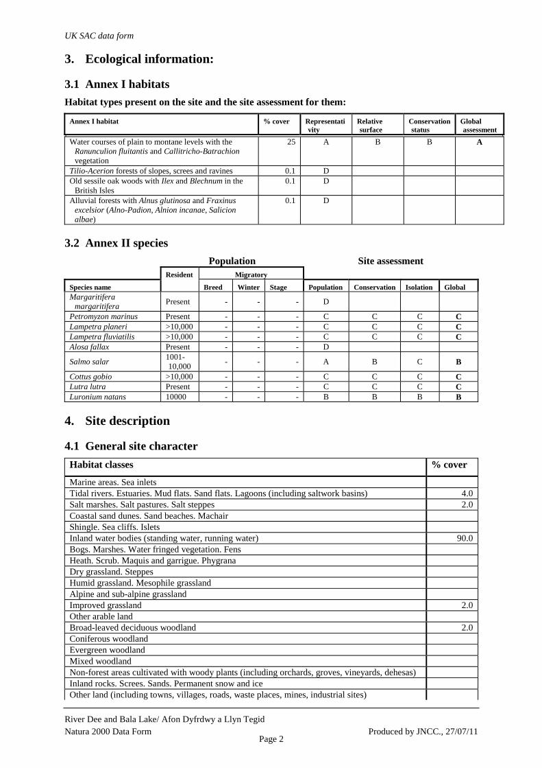
3.1 Annex I habitats Habitat types present on the site and the site assessment for them:
Annex I habitat % cover Representativity
Relative surface
Conservation status
Global assessment
Water courses of plain to montane levels with the Ranunculion fluitantis and Callitricho-Batrachion vegetation
25 A B B A
Tilio-Acerion forests of slopes, screes and ravines 0.1 D Old sessile oak woods with Ilex and Blechnum in the
British Isles 0.1 D
Alluvial forests with Alnus glutinosa and Fraxinus excelsior (Alno-Padion, Alnion incanae, Salicion albae)
0.1 D
3.2 Annex II species Population Site assessment
Resident Migratory
Species name Breed Winter Stage Population Conservation Isolation Global Margaritifera
margaritifera Present - - - D
Petromyzon marinus Present - - - C C C C Lampetra planeri >10,000 - - - C C C C Lampetra fluviatilis >10,000 - - - C C C C Alosa fallax Present - - - D
Salmo salar 1001-10,000 - - - A B C B
Cottus gobio >10,000 - - - C C C C Lutra lutra Present - - - C C C C Luronium natans 10000 - - - B B B B
4. Site description
4.1 General site character Habitat classes % cover
Marine areas. Sea inlets Tidal rivers. Estuaries. Mud flats. Sand flats. Lagoons (including saltwork basins) 4.0 Salt marshes. Salt pastures. Salt steppes 2.0 Coastal sand dunes. Sand beaches. Machair Shingle. Sea cliffs. Islets Inland water bodies (standing water, running water) 90.0 Bogs. Marshes. Water fringed vegetation. Fens Heath. Scrub. Maquis and garrigue. Phygrana Dry grassland. Steppes Humid grassland. Mesophile grassland Alpine and sub-alpine grassland Improved grassland 2.0 Other arable land Broad-leaved deciduous woodland 2.0 Coniferous woodland Evergreen woodland Mixed woodland Non-forest areas cultivated with woody plants (including orchards, groves, vineyards, dehesas) Inland rocks. Screes. Sands. Permanent snow and ice Other land (including towns, villages, roads, waste places, mines, industrial sites)
UK SAC data form
River Dee and Bala Lake/ Afon Dyfrdwy a Llyn Tegid Natura 2000 Data Form Produced by JNCC., 27/07/11
Page 3
Habitat classes % cover
Total habitat cover 100%
4.1 Other site characteristics
Soil & geology: Alluvium, Sandstone, Shingle
Geomorphology & landscape: Floodplain, Lowland
4.2 Quality and importance Water courses of plain to montane levels with the Ranunculion fluitantis and Callitricho-Batrachion vegetation • for which this is considered to be one of the best areas in the United Kingdom. Petromyzon marinus • for which the area is considered to support a significant presence. Lampetra planeri • for which the area is considered to support a significant presence. Lampetra fluviatilis • for which the area is considered to support a significant presence. Salmo salar • for which this is considered to be one of the best areas in the United Kingdom. Cottus gobio • for which the area is considered to support a significant presence. Lutra lutra • for which the area is considered to support a significant presence. Luronium natans • for which this is considered to be one of the best areas in the United Kingdom.
4.3 Vulnerability The habitats and species for which the site is designated are dependent on the maintenance of good water quality and suitable flow conditions. Fish species require suitable in-stream habitat and an unobstructed migration route. Otters also require suitable terrestrial habitat to provide cover and adequate populations of prey species. The site and its features are threatened by practices which have an adverse effect on the quality, quantity and pattern of water flows. In particular the following may threaten riverine ecosystems: inappropriate flow regulation; excessive abstraction (for industry, agriculture and domestic purposes); threats to water quality from direct and diffuse pollution; eutrophication and siltation. Degradation of riparian habitats due to engineering works, agricultural practices and invasive plant species may also have an adverse effect. The Atlantic salmon population is threatened by excessive exploitation by high sea, estuarine and recreational fisheries. Introduction of non-indigenous species could also threaten both fish and plant species. These issues are being addressed by a variety of statutory bodies that are in a position to overcome these threats through regulatory powers and partnerships with landowners, industry and other interested parties.
5. Site protection status and relation with CORINE biotopes:
5.1 Designation types at national and regional level Code % cover
UK00 (N/A) 0.8UK04 (SSSI/ASSI) 99.3
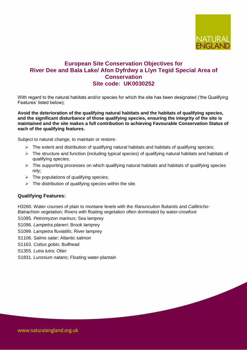
European Site Conservation Objectives for River Dee and Bala Lake/ Afon Dyfrdwy a Llyn Tegid Special Area of
Conservation Site code: UK0030252
With regard to the natural habitats and/or species for which the site has been designated („the Qualifying Features‟ listed below); Avoid the deterioration of the qualifying natural habitats and the habitats of qualifying species, and the significant disturbance of those qualifying species, ensuring the integrity of the site is maintained and the site makes a full contribution to achieving Favourable Conservation Status of each of the qualifying features. Subject to natural change, to maintain or restore:
The extent and distribution of qualifying natural habitats and habitats of qualifying species; The structure and function (including typical species) of qualifying natural habitats and habitats of
qualifying species; The supporting processes on which qualifying natural habitats and habitats of qualifying species
rely; The populations of qualifying species; The distribution of qualifying species within the site.
Qualifying Features: H3260. Water courses of plain to montane levels with the Ranunculion fluitantis and Callitricho-Batrachion vegetation; Rivers with floating vegetation often dominated by water-crowfoot S1095. Petromyzon marinus; Sea lamprey S1096. Lampetra planeri; Brook lamprey S1099. Lampetra fluviatilis; River lamprey S1106. Salmo salar; Atlantic salmon S1163. Cottus gobio; Bullhead S1355. Lutra lutra; Otter S1831. Luronium natans; Floating water-plantain

This is a cross border site
This site crosses the border between England and Wales. Some features may only occur in one Country. Explanatory Notes: European Site Conservation Objectives
European Site Conservation Objectives are those referred to in the Conservation of Habitats and Species Regulations 2010 (the “Habitats Regulations”) and Article 6(3) of the Habitats Directive 1992. They are for use when either the appropriate nature conservation body or competent authority is required to make an Appropriate Assessment under the relevant parts of the respective legislation. These conservation objectives are set for each habitat or species of a Special Area of Conservation (SAC). Where the objectives are met, the site can be said to demonstrate a high degree of integrity and the site itself makes a full contribution to achieving favourable conservation status for those features. This document is also intended for those who are preparing information to be used for an appropriate assessment by either the appropriate nature conservation body or a competent authority. As such this document cannot be definitive in how the impacts of a project can be determined. Links to selected sources of information, data and guidance which may be helpful can be found on Natural England‟s website. This list is far from exhaustive.
SOLWAY
EUROPEAN MARINE SITE
Natural England and Scottish Natural Heritage advice given in compliance with Regulation 33 (2) and in support of the implementation of The Conservation (Natural Habitats &c.) Regulations
1994 (as amended)
Interim Revision 2010

Issued 1st July 2010
3
Natural England’s and Scottish Natural Heritage’s advice for the Solway European marine site given in compliance with Regulation 33(2) and in support of the implementation of the Conservation (Natural Habitats &c.) Regulations 1994
Contents
CONTENTS........................................................................................................................... 3
LIST OF FIGURES.................................................................................................................. 6 LIST OF TABLES ................................................................................................................... 6
PREFACE ............................................................................................................................. 7
1. INTRODUCTION ....................................................................................................... 10
1.1 NATURA 2000 .......................................................................................................... 10 1.2 THE ROLE OF NATURAL ENGLAND AND SCOTTISH NATURAL HERITAGE ........................ 11 1.3 THE ROLE OF RELEVANT AUTHORITIES ....................................................................... 11 1.4 ACTIVITY OUTSIDE THE CONTROL OF RELEVANT AUTHORITIES...................................... 12 1.5 RESPONSIBILITIES UNDER OTHER CONSERVATION DESIGNATIONS ................................ 12 1.6 ROLE OF CONSERVATION OBJECTIVES........................................................................ 12 1.7 ROLE OF ADVICE ON OPERATIONS .............................................................................. 12 1.8 PRECAUTIONARY PRINCIPLE...................................................................................... 13
2 IDENTIFICATION OF INTEREST FEATURES UNDER THE HABITATS AND BIRDS DIRECTIVES....................................................................................................................... 15
2.1 INTRODUCTION ......................................................................................................... 15 2.2 QUALIFYING INTEREST FEATURES UNDER THE EU HABITATS DIRECTIVE OCCURRING IN THE EUROPEAN MARINE SITE.............................................................................................. 15 2.3 QUALIFYING INTEREST FEATURES UNDER THE EU BIRDS DIRECTIVE OCCURRING IN THE EUROPEAN MARINE SITE .................................................................................................... 16 2.4 CRITERION UNDER THE RAMSAR CONVENTION ON WETLANDS OF INTERNATIONAL IMPORTANCE OCCURRING IN THE EUROPEAN MARINE SITE ................................................... 16 2.5 OTHER QUALIFYING FEATURES OR FEATURES OF INTEREST WITHIN THE SAC, SPA AND RAMSAR DESIGNATIONS OUTSIDE THE EUROPEAN MARINE SITE............................................ 16 2.5.1 Solway Firth SAC ............................................................................................. 17 2.5.2 Upper Solway Flats & Marshes SPA ................................................................ 17 2.5.3 Upper Solway Flats & Marshes Ramsar site......................................................... 17
3 SAC INTEREST FEATURES ........................................................................................ 19
3.1 Estuaries ............................................................................................................. 19 3.1.1 General description .......................................................................................... 19 3.1.2 Importance of the Solway ................................................................................. 19 3.1.3 Key sub-features and constituent qualifying interest features ........................... 20
3.2 SANDBANKS WHICH ARE SLIGHTLY COVERED BY SEAWATER ALL THE TIME (SUBTIDAL SANDBANKS) ...................................................................................................................... 21 3.2.1 Definition .......................................................................................................... 21 3.2.2 Importance of the feature ................................................................................ 21 3.2.3 Key sub-features ............................................................................................. 22
3.3 MUDFLATS AND SANDFLATS NOT COVERED BY SEAWATER AT LOW TIDE (INTERTIDAL MUDFLATS AND SANDFLATS) ............................................................................................... 22 3.3.1 Definition .......................................................................................................... 22 3.3.2 Importance of the feature ................................................................................. 22 3.3.3 Key sub-features .............................................................................................. 22
3.4 SALICORNIA AND OTHER ANNUALS COLONISING MUD AND SAND (PIONEER SALTMARSH) 23
Issued 1st July 2010
4
3.4.1 Definition .......................................................................................................... 23 3.4.2 Importance of the feature ................................................................................. 23 3.4.3 Key sub-features .............................................................................................. 23
3.5 ATLANTIC SALT MEADOWS (GLAUCO-PUCCINELLIETALIA MARITIMAE) ............................ 24 3.5.1 Definition .......................................................................................................... 24 3.5.2 Importance of the feature ................................................................................. 24 3.5.3 Key sub-features .............................................................................................. 25
3.6 SEA LAMPREY PETROMYZON MARINUS ....................................................................... 25 3.6.1 Definition .......................................................................................................... 25 3.6.2 Importance of the feature ................................................................................. 25
3.7 RIVER LAMPREY LAMPETRA FLUVIATILIS ..................................................................... 26 3.7.1 Definition .......................................................................................................... 26 3.7.2 Importance of the feature ................................................................................. 27
3.8 REEFS ..................................................................................................................... 27 3.8.1 Definition .......................................................................................................... 27 3.8.2 Importance of the feature ................................................................................. 27
4 SPA INTEREST FEATURES ........................................................................................ 29
4.1 BACKGROUND AND CONTEXT..................................................................................... 29 4.2 DEFINITION .............................................................................................................. 29 4.3 IMPORTANCE OF THE ANNEX 1 SPECIES ..................................................................... 30 4.3.1 Key sub-features .............................................................................................. 30
4.4 IMPORTANCE OF THE INTERNATIONALLY IMPORTANT POPULATIONS OF REGULARLY OCCURRING MIGRATORY SPECIES........................................................................................ 31 4.4.1 Key sub-features .............................................................................................. 31
4.5 IMPORTANCE OF THE INTERNATIONALLY IMPORTANT ASSEMBLAGE OF WATERFOWL ...... 32 4.5.1 Key sub-features .............................................................................................. 32
5 RAMSAR INTEREST FEATURES ................................................................................ 33
5.1 BACKGROUND AND CONTEXT..................................................................................... 33 5.2 INTERNATIONALLY IMPORTANT FOR THE SUPPORT OF VULNERABLE, ENDANGERED OR CRITICALLY ENDANGERED SPECIES OR THREATENED ECOLOGICAL COMMUNITIES. .................. 34 5.2.1 Key sub-features .............................................................................................. 34
5.3 INTERNATIONALLY IMPORTANT WETLAND, REGULARLY SUPPORTING AN ASSEMBLAGE OF WATERFOWL ...................................................................................................................... 34 5.3.1 Key sub-features .............................................................................................. 34
5.4 INTERNATIONALLY IMPORTANT FOR THE SUPPORT OF 1% OR MORE OF THE INDIVIDUALS IN A POPULATION OF ONE SPECIES OR SUB-SPECIES OF WATERFOWL......................................... 34 5.4.1 Key sub-features .............................................................................................. 35
6 CONSERVATION OBJECTIVES …………………………………………………………….34
6.1 Conservation Objectives for the SAC features ………………………..…………..….36
6.2 Conservation Objectives for the SPA features (England) …………………………...35 6.2.1 The conservation objective for the internationally important populations of the regularly occurring Annex 1 bird species....................................................................... 37 6.2.2 The conservation objective for the internationally important populations of regularly occurring migratory bird species ..................................................................... 37 6.2.3 The conservation objective for the internationally important assemblage of waterfowl....................................................................................................................... 37
6.2.4 Conservation Objectives for the SPA (Scotland)………………………………….….36 6.3 CONSERVATION OBJECTIVES FOR THE RAMSAR FEATURES (ENGLAND ONLY)….......39 6.3.1 The conservation objective for the wetland which hosts internationally important populations of natterjack toad Bufo calamita ................................................................. 39 6.3.2 The conservation objective for the internationally important wetland, regularly supporting 20,000 or more waterbird............................................................................. 39
Issued 1st July 2010
5
6.3.3 The conservation objective for the internationally important wetland, regularly supporting 1% or more of the individuals in a population of one species or sub-species of waterfowl....................................................................................................................... 39
7 FAVOURABLE CONDITION TABLE ............................................................................. 39
8 INTRODUCTION TO THE ADVICE ON OPERATIONS ............................................. 59
8.1 PURPOSE OF ADVICE ................................................................................................ 59 8.2 METHODS FOR ASSESSMENT ..................................................................................... 59 8.2.1 Sensitivity assessment ..................................................................................... 59 8.2.2 Exposure assessment ...................................................................................... 60 8.2.3 Vulnerability assessment.................................................................................. 60
8.3 FORMAT OF ADVICE .................................................................................................. 60 8.4 UPDATE AND REVIEW OF ADVICE................................................................................ 61
9 ADVICE ON OPERATIONS .......................................................................................... 62
9.1 SUMMARY OF ADVICE ON OPERATIONS ....................................................................... 62 9.2 INTEREST FEATURE AND SUB-FEATURE SPECIFIC ADVICE ON OPERATIONS .................... 66 9.2.1 Estuaries .......................................................................................................... 66 9.2.2 Salicornia and other annuals colonising mud and sand ................................... 68 9.2.3 Atlantic salt meadows (Glauco-Puccinellietalia maritimae) .............................. 69 9.2.4 Mudflats and sandflats not covered by seawater at low tide ............................. 69 9.2.5 Sandbanks which are slightly covered by seawater all the time........................ 70 9.2.6 Reefs................................................................................................................ 71 9.2.7 River and sea lamprey...................................................................................... 72 9.2.8 Special Protection Area interests...................................................................... 74
10 BIBLIOGRAPHY ....................................................................................................... 86
11 GLOSSARY ............................................................................................................... 88
APPENDIX I MATRIX OF RELATIVE VULNERABILITY................................................ 92
APPENDIX II NVC SALTMARSH COMMUNITIES, SUB-COMMUNITIES, TRANSITIONAL GRASSLAND COMMUNITIES OF THE SOLWAY .............................................................. 93
APPENDIX III SOLWAY EUROPEAN MARINE SITE MANAGEMENT GROUP – MEMBERSHIP .................................................................................................................. 94
APPENDIX IV PLANS AND PROJECTS .......................................................................... 95
APPENDIX V CONSIDERATION OF DEVELOPMENT PROPOSALS AFFECTING SPA'S & SAC'S ................................................................................................................. 94
Issued 1st July 2010
6
List of Figures – Figure 1 Location of Solway European Marine Site Figure 2 Solway Firth European Marine Site: Extent and Distribution of Annex 1 Habitats. Location of SPA birds principle roost/use areas at designation. List of Tables Table 1 A summary of the designations associated with the Solway Firth European marine site and the habitats and species protected Table 2 Information on the populations of internationally important species of birds that are qualifying interest features of the Upper Solway Flats & Marshes SPA. Box 1 Glossary of terms used in Table 3 – Favourable Condition Table Table 3 Favourable Condition Table Table 4 Operations which may cause deterioration or disturbance to the Solway European marine site interest features at current levels of use Table 5 Assessment of the relative vulnerability of interest features and sub-features to different categories of operations
Issued 1st July 2010
7
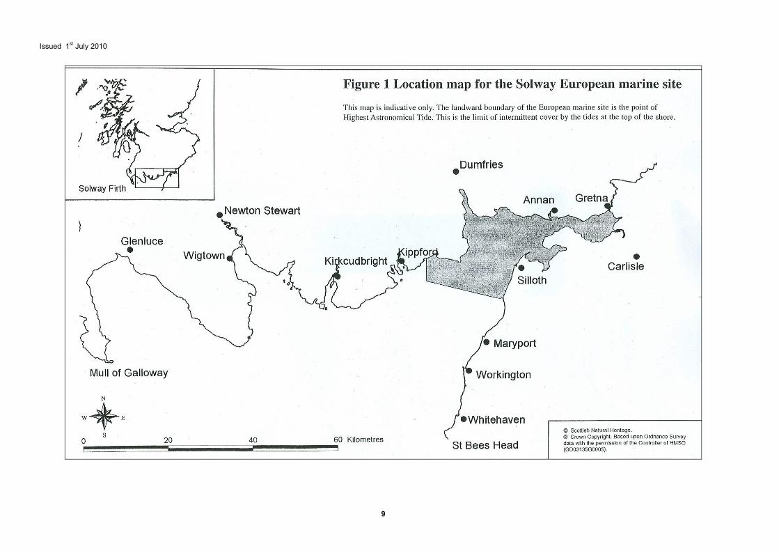
Preface This document provides Natural England’s and Scottish Natural Heritage’s joint advice to other relevant authorities as to, and in support of, (a) the conservation objectives and (b) any operations which may cause deterioration of natural habitats or the habitats of species, or disturbance of species for the Solway European Marine Site (EMS). This advice is being prepared to both comply with, and support, our obligations under Regulation 33(2) of the Conservation (Natural Habitats &c.) Regulations 1994 (as amended). The revision of this document has been undertaken by Natural England and Scottish Natural Heritage in collaboration. The reason for this update is to provide advice in relation to habitat and species qualifying interest features added as a result of the European Union moderation process. This information is also required to inform any future revision of the Solway Firth European Marine Site Management Plan 2000. It is expected that a full revision of the Regulation 33 document will be carried out by Natural England and Scottish Natural Heritage by 2011. It is important to note that cross border differences exist in the application of the Habitats Regulations, due to amendments to the legislation made either side of the border since the 1994 Regulations came into force. Differences relevant to the Reg 33 document are listed below:-
• A European Marine Site (EMS) in England is defined as any part of a European site covered (continuously or intermittently) by tidal waters or any part of the sea in or adjacent to Great Britain up to the seaward limit of territorial waters. European sites include Special Areas of Conservation (SAC) under the Habitats Directive and Special Protection Areas (SPA) under the Birds Directive.
• The Conservation Objectives (CO) for the SAC that appear in this document in Section 6.1 reflects the CO that apply within England. Reference to the CO that apply in Scotland can be found on SNH’s website www.snh.org.uk at http://gateway.snh.gov.uk/pls/portal/Sitelink.Show_Site_Document?p_pa_code=8377&p_Doc_Type_ID=29. The SAC CO for both habitats and species in Scotland do not use the prefix “Subject to natural change”
• The Conservation Objectives for the SPA, Section 6.2, are those applied by Natural
England. It is important to note that the CO that apply in Scotland also consider bird population, distribution and disturbance in addition to maintaining supporting habitat. Full details of the CO for the Upper Solway Flats and Marshes SPA can be obtained on the SNH website via Sitelink: http://gateway.snh.gov.uk/pls/portal/Sitelink.Show_Site_Document?p_pa_code=8588&p_Doc_Type_ID=29
Other legislative differences between England and Scotland were introduced on 1st April 2010. The Conservation (Natural Habitats, &c.) Regulations 1994 as amended were revoked in England and Wales and the legislation has been consolidated to produce the Conservation of Habitats and Species Regulations 2010. However, the legislation that applies in Scotland remains the Conservation (Natural Habitats, &c.) Regulations 1994 as amended. Consequently the numbering of the regulations in the two pieces of legislation are different. Regulation 33 of the Conservation (Natural Habitats, &c.) Regulations 1994 as amended corresponds to Regulation 35 of the Conservation of Habitats and Species Regulations 2010; Regulation 48 of the Conservation (Natural Habitats, &c.) Regulations 1994 as amended would correspond to Regulation 61 of the Conservation of Habitats and Species Regulations 2010. As this document is an interim update pending a full revision and as this revised version was completed before the changes were made to the legislation in England and Wales, the

Issued 1st July 2010
8
references to the legislation have not been changed throughout the document. Therefore, wherever the document refers to 'Regulation 33', 'Regulation 48', or 'Conservation (Natural Habitats, &c.) Regulations 1994 as amended', these references apply to current Scottish legislation and the reader should note the changes that now apply to the legislation in England and Wales and the corresponding regulations as set out above. Ramsar sites, under the Convention wetlands of International Importance Especially as Waterfowl Habitats 1971, are not included within the Natura 2000 definition. However, it is government policy in England that Ramsar sites be given the same consideration under the Conservation (Natural Habitats, &c.) Regulations 1994 (as amended) as SPA’s and SAC’s, particularly for the purposes of site management and development control. In Scotland it is Government policy that those sites that are only Ramsar sites (and not SAC or SPA) have the same considerations to their protection as if they were classified as SPAs (Scottish Executive revised circular 6/1995). In many instances, as is the case of the Solway EMS, these designations may coincide and our advice covers the SAC, SPA and Ramsar interests. This ‘Regulation 33 package’ is designed to help relevant and competent authorities, who have responsibilities to implement the Habitats Directive, to: • understand the international importance of the site, underlying physical processes
and the ecological requirements of the habitats and species involved; • develop a management scheme which will ensure that the ecological requirements of
the site’s interest features are met; and • set the standards against which the condition of the site’s interest features can be
determined and undertake compliance monitoring to establish whether they are in favourable condition.
In addition, the Regulation 33 package will provide a basis to inform the scope and nature of ‘appropriate assessment’ required in relation to plans and projects. This requirement stems from the Habitat Regulations and in particular Regulation 48(1) which relates to activities such as planning applications, Regulation 50(2) concerning the review of existing decisions and consents and Regulation 85B in relation to land use plans. Natural England and Scottish Natural Heritage are keeping this advice under review and may update it every six years or sooner, depending on the changing circumstances of the European Marine Site. This document is the product of the first of such reviews and replaces the earlier version produced on 29th February 2000. The main reasons for the review are: • the addition of Interest Features to the Special Area of Conservation citation following
moderation (see section 1.1). • the update of information regarding the Special Protection Area (i.e. bird numbers
and a minor alteration to the qualifying features (see section 4.3)). • provision of more detailed information regarding the Ramsar designation than was
provided in the previous version (see section 5). Where a plan or project could affect a European site the requirements of the Habitats Regulations (as amended), will need to be considered. In such circumstances the relevant nature conservation agency can provide more detailed advice to the competent/relevant authority if required. Chris Lumb Natural England 1st April 2010
Issued 1st July 2010
9
Issued 1st July 2010
10
1. Introduction This section is included to provide relevant contextual information in support of the advice required under Regulation 33. 1.1 Natura 2000 The European Union Habitats1 and Birds2 Directives are international agreements which set out a number of actions to be taken for nature conservation. The Habitats Directive aims to promote the maintenance of biodiversity, taking account of economic, social, cultural and regional requirements, and sets out measures to maintain or restore natural habitats and species of European Union interest at a favourable conservation status3. The Birds Directive protects all wild birds and their habitats within the European Union, especially migratory birds and those that are considered rare or vulnerable. The Habitats and Birds Directives include requirements for the designation of conservation areas. In the Habitats Directive these areas are Special Areas of Conservation (SACs) which support certain natural habitats or species, and in the Birds Directive, Special Protection Areas (SPAs) which support wild birds of European Union interest. These sites form a network of conservation areas known as “Natura 2000”. Where SACs or SPAs consist of areas continuously or intermittently covered by tidal waters or any part of the sea in or adjacent to Great Britain up to the limit of territorial waters, they are referred to as European Marine Sites. In 1999, lists of candidate Special Areas of Conservation were submitted to the European Commission for a process known as moderation. Shortfalls across the whole Atlantic Biogeographic Region were identified, and in the UK these have been addressed by including further interest features occurring on existing sites, extending site boundaries to include more of particular habitats and species and identifying new sites. For the Solway Firth SAC, moderation led to the inclusion of Lampetra fluviatilis (River Lamprey), Petromyzon marinus (Sea Lamprey), Reefs, Perennial vegetation of stony banks and Fixed dunes with herbaceous vegetation (“grey dunes”). The latter two interest features lie outside of the European Marine Site as they occur above the Highest Astronomical Tide, although they are part of the Solway Firth SAC. They are therefore outside the remit of this document although the requirements of the Habitats Regulations (as amended) do apply to them. Conservation Objectives for these features can be supplied on request. The Convention on Wetlands of International Importance especially as Waterfowl Habitats was signed in Ramsar, Iran in 1971. The broad objectives are to stem the loss and progressive encroachment on wetlands now and in the future, through the designation of Ramsar sites. A habitat can qualify as a Ramsar site for its representation of a wetland, the plant or animal species it supports and for its role in supporting internationally important waterfowl. In accordance with the Office of the Deputy Prime Minister’s Planning Policy Statement 9, the DEFRA statement Ramsar Sites in England – A Policy Statement (November 2006) and the Scottish Government’s National Planning Policy Guidelines 14, Ramsar sites classified under the Convention on Wetlands of International Importance4 must be given the same consideration as European sites when considering plans and projects that may affect them. The interest features of the Upper Solway Flats & Marshes Ramsar site that occur within the EMS are therefore discussed within this document.
1 Council Directive 92/43/EEC on the conservation of natural habitats of wild fauna and flora. 2 Council Directive 79/409/EEC on the conservation of wild birds. 3 A habitat or species is defined as being at favourable conservation status when its natural range and the areas it covers within that range are stable or increasing and the specific structure and functions which are necessary for its long term maintenance exist and are likely to continue to exist for the foreseeable future. 4 Convention on Wetlands of International Importance especially as Waterfowl Habitat (Ramsar Convention), 1971.
Issued 1st July 2010
11
Further guidance on European Marine Sites is contained in the HMSO document: European marine sites in England & Wales: A guide to the Conservation (Natural Habitats &c.) Regulations 1994 and to the preparation and application of management schemes (available from Defra publications), Planning Policy Statement 9: Biodiversity and Geological Conservation and Circular 06/05: Biodiversity and Geological Conservation – Statutory Obligations and Their Impact Within the Planning System. Guidance and advice on how the Habitats and Birds Directives apply in Scotland can be found in the Scottish Executive Environment and Rural Affairs Department Circular No. 6/1995 (Revised June 2000). The Regulations can be viewed at the HMSO website and the Circular can be found on the Scottish Government website. Furthermore, the websites of Natural England, Scottish Natural Heritage and Joint Nature Conservation Committee (JNCC) contain useful guidance, information and links. 1.2 The role of Natural England and Scottish Natural Heritage The Conservation (Natural Habitats &c.) Regulations 1994 (as amended) translate the Habitats Directive into law in Great Britain. It gives Natural England and Scottish Natural Heritage a statutory responsibility to advise relevant authorities as to the conservation objectives for European Marine Sites in England and Scotland respectively, and to advise these authorities which operations may cause deterioration of natural habitats or the habitats of species, or disturbance of species for which the site has been designated. This information provides the foundation for the management schemes that are developed for these sites. This document is advice required under Regulation 33 issued by both Natural England and Scottish Natural Heritage in fulfilment and in support of Regulation 33 (2) of the Conservation (Natural Habitats &c.) Regulations 1994 (the Regulation 33 package). Copies of key references quoted in this document are held at Natural England or Scottish Natural Heritage’s local offices. In addition to providing such advice, the Regulation 33 advice plus supporting information will help to inform on the scope and nature of “appropriate assessments” which the Directive requires to be undertaken for plans and projects. Natural England and Scottish Natural Heritage may also provide more detailed advice to competent and relevant authorities to assess the implications of any such plans or projects. 1.3 The role of relevant authorities The Conservation (Natural Habitats &c.) Regulations 1994 (as amended) require relevant authorities to exercise their functions so as to secure compliance with the Habitats Directive. The management scheme, first produced in 2000 but subject to ongoing review, for the Solway European Marine Site, provides the framework through which this will be done and it will be based on the advice in this package. In this respect, relevant authorities must, within their areas of jurisdiction, have regard to both direct and indirect effects on an interest feature of the site. This may include consideration of issues and impacts outside the boundary of the European marine site. Relevant authorities should ensure that all plans for the area integrate with the management scheme for the EMS. Such plans may include, amongst others, Local Development Frameworks, shoreline management plans, local Environment Agency plans, SSSI management plans, local Biodiversity Action Plans and sustainable development strategies for estuaries. This must occur to ensure that there is only a single management scheme through which all relevant authorities exercise their duties under the Conservation (Natural Habitats &c.) Regulations (as amended).
Issued 1st July 2010
12
Relevant authorities also need to have regard to changing circumstances of the SAC, SPA and Ramsar site and may therefore need to modify the management scheme and or the way in which they exercise their functions so as to maintain the favourable condition of interest features concerned in the long term. There is no requirement for relevant authorities to take any actions outside their statutory functions. 1.4 Activity outside the control of relevant authorities Nothing within this package will require relevant authorities to undertake any actions or ameliorate changes in the condition of qualifying interest features if it is shown that changes result wholly from natural causes5. This also applies if the changes, although causing deterioration or disturbance to the qualifying interest features, are the result of human or natural events outside their control. On the Solway European Marine Site a management group has been established and should be used to alert either Natural England or Scottish Natural Heritage to such issues so that they may be assessed and any appropriate measures taken. This does not however preclude relevant authorities from taking action to prevent deterioration to the qualifying interest features, for example by introducing or promoting codes of practice through the management group. It should be noted that in Scotland the Scottish Marine Wildlife Watching Code (SMWWC) was produced in 2007 in fulfilment of the requirement under section 51 of the Nature Conservation (Scotland) Act 2004. This code sets out recommendations, advice and information relating to commercial and leisure activities involving the watching of marine wildlife. 1.5 Responsibilities under other conservation designations In addition to its SAC, SPA and Ramsar status, parts of the Solway are also designated and subject to agreements under other conservation legislation (e.g. SSSIs notified under the Wildlife and Countryside Act 1981 as amended 1985, 2004 & 2007 and by the Nature Conservation (Scotland) Act 2004). The obligations of relevant authorities and other organisations under such designations are not affected by the advice contained in this document. 1.6 Role of conservation objectives Section 6 of this document sets out the conservation objectives for the Solway European Marine Site as required under Regulation 33 (2)(a). They are the starting point from which management schemes and monitoring programmes are developed as they provide the basis for determining what is likely to cause a significant effect, and for informing on the scope of appropriate assessments of plans or projects. The conservation objectives set out what needs to be achieved and thus deliver the aims of the Directive. 1.7 Role of advice on operations The advice on operations set out in Sections 8 and 9 provides the basis for discussion about the nature and extent of the operations taking place within or close to the site, and which may have an impact on its interest features. It is given on the basis of the working assumption that sites were in a favourable condition at the time they were identified. The advice should also be used to identify the extent to which existing measures of control, management and use are, or can be made consistent with the conservation objectives and thereby focus the attention of relevant authorities on areas that may need management measures.
5 Determination of what constitutes natural change will be based on the best available information and scientific opinion at the time.
Issued 1st July 2010
13
This operations advice will be refined through further detailed discussions with the management and advisory groups in formulating and agreeing a revised management scheme with agreed time scales for implementation. 1.8 Precautionary Principle Assessment of impacts of human activities on a site should use the best scientific information available. However, when damage to a site is both potentially significant and uncertain it is appropriate to act on the basis of the precautionary principle, outlined below. All forms of environmental risk should be tested against the precautionary principle. This means that where there are real risks to the site, lack of full scientific certainty should not be used as a reason for postponing measures that are likely to be cost effective in preventing such damage. It does not however imply that the suggested cause of such damage must be eradicated unless proved to be harmless and it cannot be used as a licence to invent hypothetical consequences. Moreover, it is important, when considering whether the information available is sufficient, to take account of the associated balance of likely cost, including environmental costs, and benefits (DETR& the Welsh Office, 1998).
Issued 1st July 2010
14
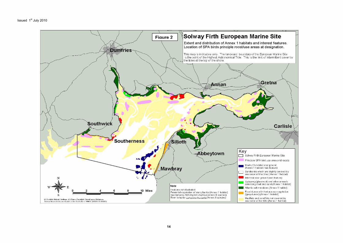
Figure 2
Issued 1st July 2010
15
2 Identification of interest features under the Habitats and Birds Directives This section is included to provide relevant contextual information in support of the advice required under Regulation 33 (2). 2.1 Introduction The Solway is a large shallow complex estuary formed by a variety of historical physical influences including glaciation, river erosion, sea level change and geological barriers from hard rock outcrops. Of the few examples of these estuaries within Great Britain, the Solway is the largest. It is also one of the least industrialised and most natural estuary systems in Europe (Brown et al., 1997). Located on the west coast of Britain, it straddles the border between England and Scotland (Figure 1), forming an extensive system draining into the Irish Sea. The inner firth drains several rivers including, Lochar Water, Kirtle Water, the Nith, Sark, Annan, Esk, Eden, Wampool and Waver. The estuary system supports extensive areas of saltmarsh, both pioneer and Atlantic salt meadow, as well as large areas of intertidal mudflats, reefs and sandflats, and subtidal sandbanks each of which are of international importance in their own right. The Solway Firth is a Special Area of Conservation (SAC) and the Upper Solway Flats and Marshes are a Special Protection Area (SPA) and Ramsar site, the boundaries of which are illustrated in Figure 2. The site includes the subsumed Rockcliffe Marsh SPA and Ramsar site, which was originally the subject of a separate classification. The marine components of the SAC and SPA are within the European Marine Site, but for the purpose of this advice, the Ramsar components occurring below Highest Astronomical Tide are also included in this document. Accordingly, the advice contained covers the SAC habitat and species interests, the SPA bird interests of the European Marine Site, and the Ramsar habitat and bird interests. The features, for which the SAC, SPA and RAMSAR have been selected, known as qualifying interest features, are listed below. These qualifying interest features and ecologically important components, termed sub-features, are described in more detail in Sections 3, 4 and 5 and mapped in Figure 2 to show their location, distribution and extent. 2.2 Qualifying interest features under the EU Habitats Directive occurring in the European Marine Site The Solway qualifies as a SAC for the following Annex I habitats and Annex II species:
• Estuaries: • Salicornia and other annuals colonising mud and sand (referred to within this
document as pioneer saltmarsh); • Atlantic salt meadows Glauco-Puccinellietalia maritimae (also commonly
referred to as saltmarsh); • Mudflats and sandflats not covered by sea water at low tide (referred to within
this document as intertidal mudflats and sandflats); and • Sandbanks which are slightly covered by sea water at all times (referred to
within this document as subtidal sandbanks). • Reefs • Lampetra fluviatilis (River lamprey) • Petromyzon marinus (Sea lamprey)

Issued 1st July 2010
16
2.3 Qualifying interest features under the EU Birds Directive occurring in the European Marine Site The Upper Solway Flats and Marshes (including Rockcliffe Marsh) qualifies as a SPA under the EU Birds Directive in that it supports:
• internationally important populations of regularly occurring Annex 1 species; • internationally important populations of regularly occurring migratory species;
and • an internationally important assemblage of waterfowl.
The Upper Solway Flats and Marshes SPA was classified in 1986 and it is that citation on which this advice is based along with additional qualifying species identified during the 2001 SPA review. A more detailed explanation of the SPA can be found in Section 4 of this document and a list of individual bird species associated with the site, including population numbers, is given in Table 2. 2.4 Criterion under the Ramsar Convention on Wetlands of International Importance occurring in the European Marine Site The Upper Solway Flats & Marshes Ramsar Site qualifies under Criterion 2 as it supports vulnerable, endangered species or threatened ecological communities;
• Supports over 10% of the British population of natterjack toad Bufo calamita (Habitats Directive Annex IV species (S1202))
The Upper Solway Flats & Marshes Ramsar Site qualifies under Criterion 5 as it regularly supports
• 20,000 or more waterfowl (5 year peak mean 1998/99 – 2002/03) The Upper Solway Flats & Marshes Ramsar Site qualifies under Criterion 6 as it regularly supports
• 1% or more of the individuals in a population of one species or sub-species of waterfowl
The Upper Solway Flats & Marshes Ramsar site, with an area of 43,636.73ha, was listed on 30th November 1992. 2.5 Other qualifying features or features of interest within the SAC, SPA and Ramsar designations outside the European Marine Site The features discussed below either qualify (SAC) or represent a vital component (SPA and RAMSAR) for each designation but do not occur within the European Marine Site as they occur above the Highest Astronomical Tide (HAT). The conservation objectives for the qualifying interest features of the SAC which occur outside of the European Marine Site boundary are provided in Section 6 of this document. However, there are no specific conservation objectives within this document for the habitats, discussed below, that support the qualifying bird populations of the SPA and RAMSAR sites but lie outside the EMS boundary. Their protection, under the Conservation (Natural Habitat &c.) Regulations 1994 (as amended), is equivalent to that for those within the EMS. Relevant authorities need to have regard to such adjacent interests as they may be affected by activities taking place within, or adjacent to the European Marine Site.
Issued 1st July 2010
17
2.5.1 Solway Firth SAC The Solway Firth also qualifies as a SAC for the Annex 1 habitats
� Fixed dunes with herbaceous vegetation (“grey dunes”) (dune grassland) � Perennial vegetation of stony banks (Coastal shingle vegetation outside the reach of
waves). 2.5.2 Upper Solway Flats & Marshes SPA
There are a number of habitats, such as wet grazing marsh that are utilised by waterfowl, which occur within the boundary of the SPA and support the qualifying bird species but, as they are above Highest Astronomical Tide, are not discussed within this document. Advice around the appropriate management of these features can be supplied on request. 2.5.3 Upper Solway Flats & Marshes Ramsar site
As with the SPA, the populations and assemblages of birds that led to the Ramsar designation of the Upper Solway flats and marshes also utilise habitats that lie within the Ramsar site but occur outside of the European Marine Site. Relevant authorities must be aware of these but they are not included in this document. Advice around the appropriate management of these features can be supplied on request.
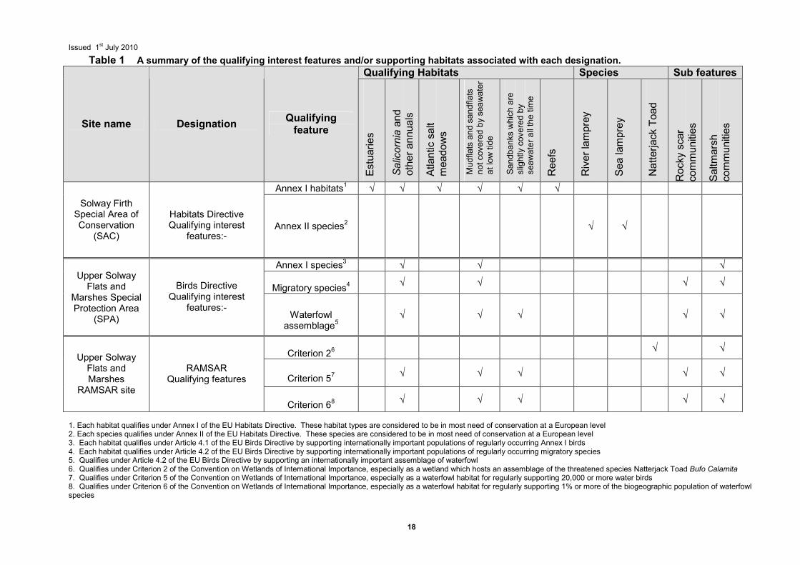
Issued 1st July 2010
18
Table 1 A summary of the qualifying interest features and/or supporting habitats associated with each designation.
Qualifying Habitats Species Sub features
Site name Designation Qualifying feature
Estuaries
Salicornia and
other annuals
Atlantic salt
meadows
Mudflats and sandflats
not covered by seawater
at low tide
Sandbanks which are
slightly covered by
seawater all the time
Reefs
River lamprey
Sea lamprey
Natterjack Toad
Rocky scar
communities
Saltmarsh
communities
Annex I habitats1 √ √ √ √ √ √ Solway Firth Special Area of Conservation
(SAC)
Habitats Directive Qualifying interest
features:- Annex II species2 √ √
Annex I species3 √ √ √
Migratory species4 √ √ √ √
Upper Solway Flats and
Marshes Special Protection Area
(SPA)
Birds Directive
Qualifying interest features:-
Waterfowl assemblage5
√ √ √ √ √
Criterion 26 √ √
Criterion 57 √ √ √ √ √
Upper Solway Flats and Marshes
RAMSAR site
RAMSAR
Qualifying features
Criterion 68 √ √ √ √ √
1. Each habitat qualifies under Annex I of the EU Habitats Directive. These habitat types are considered to be in most need of conservation at a European level 2. Each species qualifies under Annex II of the EU Habitats Directive. These species are considered to be in most need of conservation at a European level 3. Each habitat qualifies under Article 4.1 of the EU Birds Directive by supporting internationally important populations of regularly occurring Annex I birds 4. Each habitat qualifies under Article 4.2 of the EU Birds Directive by supporting internationally important populations of regularly occurring migratory species 5. Qualifies under Article 4.2 of the EU Birds Directive by supporting an internationally important assemblage of waterfowl 6. Qualifies under Criterion 2 of the Convention on Wetlands of International Importance, especially as a wetland which hosts an assemblage of the threatened species Natterjack Toad Bufo Calamita 7. Qualifies under Criterion 5 of the Convention on Wetlands of International Importance, especially as a waterfowl habitat for regularly supporting 20,000 or more water birds 8. Qualifies under Criterion 6 of the Convention on Wetlands of International Importance, especially as a waterfowl habitat for regularly supporting 1% or more of the biogeographic population of waterfowl species
Issued 1st July 2010
19
3 SAC interest features This section describes and explains the importance of the SAC interest features of the Solway European marine site and is provided in support of the advice required under Regulation 33 (2). 3.1 Estuaries 3.1.1 General description Estuaries are complex and highly productive systems supporting a wide range of habitat types. They form the interface between freshwater and marine environments and extend from the upper limit of tidal influences to the open sea. Unlike large shallow inlets and bays, there is generally a substantial freshwater influence within estuaries. The mixing of freshwater and seawater and the reduced wave action in the shelter of the estuary lead to deposition of fine sediments, often forming extensive intertidal sandflats and mudflats which, at higher elevations within the tidal range, are exposed for sufficiently long periods to become vegetated with salt tolerant plants and form saltmarshes (or merse). Typical animals associated with intertidal mudflats include the gastropod mollusc Hydrobia spp., sandhoppers Corophium spp. and a variety of polychaete worms; all of which are food for migratory waterfowl and which make many of Britain’s estuaries of international importance for over-wintering waterfowl and waders. Where rock occurs, there are restricted communities characteristic of brackish flowing water, consisting of sparse fucoid algae and species of barnacle and hydroids. Towards the mouth of the estuary, the water gradually becomes more saline and the silt content of the sediment tends to decline. Here the animal communities of the sediments are dominated by invertebrates such as polychaete worms and bivalve molluscs. 3.1.2 Importance of the Solway The Solway Firth estuary complex is one of the largest, least industrialised and most natural sandy estuaries in Europe (Brown et al. 1997). The Solway Firth SAC, with a total area of around 44,000ha, supports extensive areas of Atlantic salt meadows, pioneer saltmarsh, intertidal mudflats and sandflats, subtidal sandbanks, reefs, coastal shingle vegetation and dune grassland. Each of these is of international importance, qualifying under the Habitats Directive as Annex I Habitats in their own right, and are qualifying interest features of the Solway Firth SAC. At low water the area of the inner Solway almost completely dries out exposing extensive fringing mudflats and sandflats, which together with the extensive subtidal sandbanks, form the third largest continuous area of sedimentary habitats in Britain. The geomorphology and vegetation of the estuarine saltmarsh or merse are of international importance, with broad transitions to mature ‘upper marsh’ being particularly well represented. Tidal currents are moderately strong and levels of wave energy can be high, with considerable seasonal fluctuations in water temperature due to the shallow nature of the estuary. The combination of environmental and ecological characteristics is most unusual for British estuaries. The Solway Firth provides migratory passage for the Annex II species, sea lamprey Petromyzon marinus and river lamprey Lampetra fluviatilis, to and from spawning and nursery grounds in a number of rivers, including the Eden, which is designated as a SAC for these species. The estuary is also important for migrating fish, particularly sea trout Salmo trutta and salmon Salmo salar as they pass into the rivers Nith, Annan, Sark, Kirtle Water, Border Esk, Eden and Wampool. The estuary supports additional fish populations including
Issued 1st July 2010
20
a number of Annex II6 Species such as allis shad Alosa alosa and twaite shad Alosa fallax, which migrate through the Solway Firth to freshwater breeding grounds. Annex IV7 species associated with the estuary include harbour porpoise Phocoena phocoena which frequents the area, otter Lutra lutra which is frequently associated with the coastal areas, while turtles, particularly leatherback Dermochelys coriaceae have been recorded infrequently. Finally, the area is important for its breeding population of Natterjack Toad Bufo Calamita. The site also supports other typical estuarine fish populations, such as flounder and other flat fish including plaice, sole and dab. The mudflats and sandflats of the inner estuary provide nursery and feeding grounds for commercially and recreationally important fish species, particularly shellfish such as cockle Cerastoderma edule, as well as providing a significant food source for birds. The whole estuarine complex is important for wintering wildfowl (ducks, geese and swans) and waders, and is a vital link in a chain of west coast UK estuaries used by migrating waterbirds. The SPA supports virtually the entire Svalbard population of Barnacle Goose Branta leucopsis over the winter (see sections 4 and 5 for more details regarding bird species). 3.1.3 Key sub-features and constituent qualifying interest features Rocky scar communities - Intertidal and subtidal scar ground (exposed boulders and rocks) is a characteristic feature of the Solway Firth with extensive areas of scar ground present on the English side (Solway Firth Partnership 1996). These scar areas which remain clear of sand, support a rich and well developed epifauna typical of rocky areas, such as the brown seaweed (fucoids) and the edible mussel Mytilus edulis. The habitat is also important for crabs, various species of fish and supports the reef building polychaete worm Sabellaria alveolata in the intertidal and Sabellaria spinulosa in the subtidal. These are specialist communities that can tolerate scour and are considered to be nationally scarce. The extent of exposed scar varies as it is scoured and buried by the constantly shifting intertidal flats. However, an estimated 400 ha. of scar is thought to be currently uncovered by sediment.
Rocky scars, such as those at Southerness, mostly have communities similar to those of rocky shores. The scar grounds generally lack the littoral fringe and supralittoral communities of bedrock, but are characterised by spiral wrack Fucus spiralis above a band of bladder wrack Fucus vesiculosus or knotted wrack Ascophyllum nodosum depending on the prevalent wave exposure at the site. Many rocky scar sites also have edible mussel Mytilus edulis beds. Invertebrates, including common limpets Patella vulgata, the barnacles Semibalanus balanoides and Elminius modestus and dog whelk Nucella lapillus are common to these areas. On areas where these rocky shore scars are subject to reduced salinity, they support the brown seaweed horned wrack Fucus ceranoides. The Fucus ceranoides biotope is scarce in the UK.
Areas of scar subject to more frequent scouring by sand, such as Hogus Point and Powfoot scars support species such as the periwinkle Littorina littorea and barnacles Semibalanus balanoides and Elminius modestus. There is very little fucoid growth as a result of the frequent scour. Mussel Mytilus edulis beds are also commonly associated with these areas. Subtidal sandbanks – subtidal sandbanks within the Solway are the best example of muddy sandbanks influenced by reduced salinity in the UK. This habitat is included in Annex I of
6 A species listed in Annex II of the Habitats Directive and for which Special Areas of Conservation can be selected. 7 Animal and plant species listed in Annex IV of the Habitats Directive as being in need of strict protection.
Issued 1st July 2010
21
the Habitats Directive and is a qualifying interest feature of the Solway Firth SAC in its own right. Therefore a detailed description is supplied separately in section 3.2. Intertidal mudflats and sandflats – intertidal sediments contribute significantly to the habitat diversity of the site and to its international importance. This habitat is included in Annex I of the Habitats Directive and is a qualifying interest feature of the Solway Firth SAC in its own right. Therefore a detailed description is supplied separately in section 3.3. Pioneer saltmarsh – pioneer saltmarsh is part of a complete sequence of saltmarsh types which occur within the estuary. This habitat, Salicornia and other annuals colonising mud and sand, is included in Annex I of the Habitats Directive and is a qualifying interest feature of the Solway Firth SAC in its own right. Therefore a detailed description is supplied separately in section 3.4. Saltmarsh – the Atlantic salt meadows which occur within the Solway comprise one of the largest areas of saltmarsh in Britain. This habitat is included in Annex I of the Habitats Directive and is a qualifying interest feature of the Solway Firth SAC in its own right. Therefore a detailed description is supplied separately in section 3.5. Sea lamprey - Petromyzon marinus – The Solway is regarded as an important migration route for this species. This species is included in Annex II of the Habitats Directive and is a qualifying interest feature of the Solway Firth SAC in its own right. Therefore a detailed description is supplied separately in section 3.6
River lamprey - Lampetra fluviatilis – The Solway provides an important marine migration route for this species adjacent to their spawning and nursery grounds in a number of rivers. This species is included in Annex II of the Habitats Directive and is a qualifying interest feature of the Solway Firth SAC in its own right. Therefore a detailed description is supplied separately in section 3.7. Reefs - Reefs are rocky marine habitats or biological concretions that rise from the seabed. They are usually subtidal but may extend as an unbroken transition into the intertidal zone, in which case they are exposed at low tide. This habitat is included in Annex I of the Habitats Directive and is a qualifying interest feature of the Solway Firth SAC in its own right. Therefore a detailed description is supplied separately in section 3.8. 3.2 Sandbanks which are slightly covered by seawater all the time (Subtidal sandbanks) 3.2.1 Definition This habitat primarily consists of soft sediment seabeds that are permanently submerged and predominantly surrounded by deeper water. Sandbanks are elevated, elongated, rounded or irregular topographic features which consist mainly of sandy sediments, although may include coarse boulders and cobbles or finer mud. ‘Slightly covered by seawater all the time’ means that the water depth above the sandbank is seldom more than 20m below chart datum. However, sandbanks can extend below 20m of water depth and are included within this definition if they have the associated biological assemblage. Typical species associated with subtidal sandbanks include a burrowing fauna of worms, crustaceans, bivalve molluscs and echinoderms. The mobile fauna at the surface of the sandbank often includes shrimps, crabs and fish. 3.2.2 Importance of the feature
Issued 1st July 2010
22
The subtidal sandbanks of the Solway Firth are the best example of muddy sandbanks influenced by reduced salinity in the UK. The subtidal sediment banks are separated by six main river channels which are continually changing their patterns of erosion and accretion. They play an important role in maintaining a sediment balance within the estuary, acting as both a source and sink for sediments. The sublittoral sediment communities of the inner estuary is typically sparse but becomes richer towards the outer estuary due to the less extreme environmental conditions and a more varied substrate including patches of mud, silt, stone and outcrops of underlying hard bed rock amongst sand. These sediments provide spawning grounds and nursery grounds for fish, invertebrates and shrimps. 3.2.3 Key sub-features Infralittoral gravel and sand communities - to the west of the Solway Firth, the sandbanks are predominantly fine to medium sands, supporting rich and diverse communities dominated by the polychaete worm Nephtys cirrosa and the amphipod Bathyporeia elegans (Cutts and Hemingway 1996). Other species present include the polychaete Magelona mirabilis, the bivalves Fabulina fabula, Spisula subtruncata and Angulus tenuis, and juvenile horse mussels Modiolus modiolus. Towards the middle channel and the east, the banks are mainly gravely clean sands with low species diversity, the key species being Nephtys cirrosa in clean sand and Microphthalmus similis in the areas of gravel and pebbles (Cutts and Hemingway 1996). 3.3 Mudflats and sandflats not covered by seawater at low tide (Intertidal mudflats and sandflats) 3.3.1 Definition Intertidal mudflats and sandflats are submerged at high tide and exposed at low tide. They form a major component of estuaries and embayments in the UK but also occur along the open coast. The physical structure of the intertidal flats can range from the mobile coarse sand beaches of wave exposed coasts to the fine stable sediment mudflats of estuaries. This habitat type can often be divided into three broad categories, clean sands, muddy sands and muds, although in practice there is a continuous gradient between them. Within this range the plant and animal communities present vary according to the type of sediment, its stability and the salinity of the water. 3.3.2 Importance of the feature The mudflats and sandflats of the Solway Firth comprise the third largest continuous area of intertidal mud and sand in the UK, after the Wash and Morecambe Bay (Solway Firth Partnership, 1996). They contribute significantly to the habitat diversity of the site and to its international importance. The flats are highly mobile and consist predominantly of fine sands and silt. Fine sandy sediments occur in the inner estuary with coarser sediments in the outer reaches. The presence of fine sands rather than muds, due to the lack of mud being imported into the system from rivers (Marshall, 1962), is unusual in conditions of estuarine salinity. A typical estuarine fauna is supported by the flats with variation in the dominant infauna dependent on variation in sediment composition and position on the shore. The flats provide a valuable food source for feeding birds and fish as well as acting as a refuge for roosting birds. A range of factors including, salinity, sediment grain size, organic content and wave exposure influence the sediment communities within the Solway Firth. 3.3.3 Key sub-features Muddy sand communities - muddy sand communities are found towards the head of the Solway Firth (Covey and Emblow, 1992; Cutts and Hemingway, 1996). Communities here are dominated by polychaetes such as the lugworm Arenicola marina and bivalves such as
Issued 1st July 2010
23
the common cockle Cerastoderma edule and the Baltic tellin Macoma balthica. The cockle beds of the Inner Solway are a characteristic feature of the estuarine complex. They play a crucial role in the functioning and health of the estuary itself, acting as filter feeders and primary consumers which take phytoplankton out of the system and provide pathways for nutrient recycling and making organic matter available to other consumers. Sandy mud communities - this community occurs in sandy mud in sheltered or extremely sheltered conditions often in variable or low salinities. It is widespread on the mid and lower shores of much of the inner Solway as well as the sheltered estuaries of the outer Solway (Solway Firth Partnership 1996). The most abundant species include the ragworm Hediste diversicolor and the Baltic tellin Macoma balthica. The burrowing sandhopper Corophium volutator and the laver spire shell Hydrobia ulvae are also often common within this community. Gravel and clean sand communities - in areas of relatively high wave exposure, where the sediments are characteristically coarse, the faunal community is dominated by burrowing amphipods, mainly Bathyporeia spp. (Cutts and Hemingway 1996). Medium clean sands to fine sand in moderately exposed reaches of the Solway Firth are dominated by bristleworms such as Nephtys cirrosa and Nephtys hombergii, and bivalve shellfish such as Angulus tenuis and Donax vittatus. Transitional communities occur with changes in grain size. In areas of fine or very fine sand typical species include bristleworms Nephtys spp., Scoloplos armiger, the lugworm Arenicola marina, and the amphipod Bathyporeia pelagica (Covey and Emblow 1992). These communities are tolerant of variable or low salinities. Areas greatly influenced by freshwater run-off are typically dominated by oligochaete worms. 3.4 Salicornia and other annuals colonising mud and sand (Pioneer saltmarsh) 3.4.1 Definition Pioneer saltmarsh occurs at the lowest levels of the saltmarsh zone, where immersion occurs at nearly every tide. It colonises intertidal mudflats and sandflats in areas protected from strong wave action and is an important precursor to the development of more stable vegetation. Pioneer saltmarsh develops at the lower reaches of saltmarshes where vegetation is frequently flooded by the tide and can also colonise open creek sides, depressions or pans within saltmarsh, as well as disturbed areas of upper saltmarshes. 3.4.2 Importance of the feature Pioneer saltmarsh on the Solway Firth has been selected to represent the habitat type in north-west England and south-west Scotland. It is part of a complete sequence of saltmarsh types which occur on the Solway Firth from pioneer communities through to mid and high saltmarsh and tidal grazing marsh (Brown et al. 1997). The distribution of pioneer saltmarsh varies in response to changing river channels and erosion of existing marsh and forms part of a dynamic suite of maritime habitat types for which the site has been separately selected. The communities present in the Solway Firth are dominated by glasswort Salicornia spp. Glasswort, which is largely absent from other Scottish firths (Burd 1987), forms a distinct zone in the lower marshes of the Solway Firth, but is also characteristic of other bare mud and sand habitats such as the sides of creeks, borrow pits, eroded marsh and at lower elevations in tidal range. 3.4.3 Key sub-features
Issued 1st July 2010
24
Annual Salicornia spp. communities - this plant community is limited to those annual species that can withstand the tidal regime, and will exhibit considerable seasonal variation. The density of plants will vary according to local conditions, such as sediment composition and exposure to tides. 3.5 Atlantic salt meadows (Glauco-puccinellietalia maritimae) 3.5.1 Definition Atlantic salt meadows Glauco-puccinellietalia maritimae occur on North Sea, English Channel and Atlantic shores. They develop when halophytic vegetation colonises soft intertidal sediments of mud and sand protected from strong wave action. This vegetation forms the middle and upper reaches of saltmarshes where tidal inundation occurs, but with decreasing frequency and duration. Saltmarshes play a fundamental role within estuaries bringing stability to coastal margins and operating as a source of primary productivity (Davison et al. 1991). Atlantic salt meadows comprise a wide range of vegetation types which are zoned according to frequency and duration of tidal inundation; this can often be blurred by other factors such as climate which will affect periods of inundation. Those Atlantic salt meadows which are grazed differ significantly from those which are ungrazed, in terms of both structure and species composition. Areas that are overgrazed are generally more species-poor and dominated by grasses such as Puccinellia spp. This in turn affects related invertebrate communities and breeding and feeding birds. The upper saltmarsh of the Solway is regarded as particularly important because it has been lost in many other estuaries as a result of land claim and overgrazing. 3.5.2 Importance of the feature The Solway Firth has been selected for its Atlantic salt meadows for their size and the extent of uninterrupted transitions. The overall area of this saltmarsh type in the UK is some 29,000 ha, of which around 3,800 ha, or 13% occurs on the Solway Firth where they have been little affected by land claim, enclosures and agricultural intensification, with the result that they demonstrate unusually large transitions to freshwater grassland communities. Unlike more southerly saltmarshes, those of the Solway Firth develop on sediments with a higher sand content. Furthermore, some of the plants that they support, such as sea purslane Atriplex portulacoides, common sea lavender Limonium vulgare and lax-flowered sea lavender Limonium humile are at the northern limits of their range in the UK (Solway Firth Partnership 1996). As the Atlantic salt meadows of the Solway Firth are important for a variety of wintering waterfowl which graze them, it is also important to maintain their structure to ensure continued use by waterfowl considered as typical or characteristic of these marshes. The saltmarsh of the inner Solway is notable for its geomorphological structure. Terraces are evident within the marshes which have developed as a result of saltmarsh forming as the land moves in relation to the sea (a phenomenon referred to as isostatic adjustment) (Marshall 1962). These marshes provide breeding pools and food sources for natterjack toads Bufo calamita which, although not an interest feature of the SAC in their own right, are a feature of the Ramsar site (see section 5.2) and an Annex IV species of the Habitats Directive. The natterjack toad population within the inner Solway saltmarshes is thought to amount to over 10% of the breeding population in the UK. Otters Lutra lutra make extensive use of the inner Solway intertidal habitats for shelter and food; this population is considered to be an important resource for the recolonisation of northern England (Solway Firth Partnership 1996). Otters are listed as Annex II and Annex IV species in the Habitats Directive but are not an interest feature for this site. The marshes
Issued 1st July 2010
25
also support all four types of salt pan, primary, secondary, channel and residual pans (Marshall 1962). 3.5.3 Key sub-features Low marsh communities – lying immediately above the pioneer saltmarsh zone, the saltmarsh communities here experience a greater number of tidal inundations than the mid- or upper- marsh. As a result of this, the vegetation communities of the low marsh and mid-low marsh are often relatively species poor, composed of halophytes that can withstand such conditions. Communities of common saltmarsh grass Puccinellia maritima (NVC community SM13) and the annual glasswort Salicornia spp. (NVC community SM8) typify low marsh. Mid marsh communities - the mid upper marsh is dominated by the saltmarsh rush Juncus gerardii with smaller areas of saltmarsh grass/fescue communities Puccinellia/Festuca (NVC community SM16). In the mid marsh zone, as the number of tidal inundations becomes less frequent, the vegetation becomes more diverse, with a more complex structure and a greater proportion of herbs. Upper marsh communities - at the upper levels of the marsh, tidal inundation only occurs at the highest spring tides. The vegetation communities here reflect this with some species being restricted to this zone. The upper marsh communities will grade into the transitional communities at around extreme high water spring tide mark, these may be freshwater habitats, woodlands or grassland. Where the upper marshes have been truncated by sea walls, these transitions are lost. Such truncations can also affect the succession of saltmarshes and their ability to respond to changes in sea levels. 3.6 Sea lamprey Petromyzon marinus 3.6.1 Definition The sea lamprey is the largest and least common of the three lamprey species found in the UK and may reach a length of 100cm and weigh 2.5kg, although it is more usually about 50cm long. Relatively little is known about the precise habitats occupied by adult sea lamprey, but it is thought to occur over much of the North Atlantic, both in shallow coastal waters and deep offshore. The species is anadromous - growing to maturity in the sea and migrating into fresh water to spawn in upstream clean gravel beds. The larvae (known as ammocoetes) migrate downstream to spend several years living in burrows within silt beds before metamorphosing into adults and migrating downstream to the sea. Sea lampreys have a widespread distribution within the UK, although populations have declined over the last hundred years due to pollution and barriers to migration. Sea lampreys are probably more highly migratory than other species of lamprey and also appear to be particularly poor at ascending obstacles to migration. They have consequently become extinct in a number of rivers (Maitland, 1997). Lampreys are parasitic and feed by attaching their mouthparts to the skin of fish, rasping away to penetrate and eat the flesh and muscle. Some prey may not recover from such an attack, although there is no evidence of any significant damage to native fish stocks by lampreys. Prey species may include salmon, trout, eel, flounder, dab, herring, sprat, allis and twaite shad. 3.6.2 Importance of the feature Very little is known about the sea lamprey in the Solway Firth, except that the estuary forms an essential part of the species’ migratory route. It is thought that the mature adults begin their upstream migration to spawn in many of the rivers which feed into the Solway in May, although little else is known about their behaviour. It is thought that the migration is
Issued 1st July 2010
26
triggered by both water temperature and pheromones from juvenile lamprey. After spending several years as ammocoetes, juvenile lamprey are thought to begin their descent into the estuary between October and March. The UK is one of the strongholds of the sea lamprey, which, although rare and threatened in some European countries and extinct in others, is fairly widespread in England and other parts of the UK. Marine sites selected for designation are those that are considered to be important migration routes and/or feeding grounds. Sea lamprey are known to use the Solway Firth as a migratory passage to and from their spawning and nursery grounds in the River Esk and River Eden, which is designated as an SAC for this species, and other river systems flowing into the estuary. The River Eden SAC is characterised by extensive areas of gravels and fine silts, which provide excellent conditions for spawning and nursery areas and supports a large and healthy population of sea lamprey. 3.7 River lamprey Lampetra fluviatilis 3.7.1 Definition The average adult length of the river lamprey is around 30cm with a weight of some 60g. It can be distinguished from sea lamprey by the smaller size, colouration and pattern of the teeth. It is confined to Western Europe, migrating from the sea to spawn in silt beds of many UK rivers. The species is normally anadromous - growing to maturity in estuaries and coastal waters and then migrating into freshwater to spawn. River lamprey must not be confused with the brook lamprey, Lampetra planeri, which are confined to rivers for the duration of their life cycle. Like all species of lamprey, it requires clean gravel for spawning and marginal silt or sand for burrowing juveniles. The larvae spend several years in silt beds before metamorphosing and migrating downstream into estuaries. Here they can be found in large numbers feeding on estuarine fish, particularly herring, sprat and flounder. After 1-2 years, they stop feeding in the autumn and migrate upstream to spawn in freshwater. Spawning in British rivers commences when the water temperature reaches 10 -11 degrees centigrade, usually during March and April. There can be high mortality at this time from predators, including birds and mammals, but all lampreys die following spawning. Pollution - either from direct toxic effects or through smothering of eggs, and barriers to migration are of particular concern for this species. Similarly, river engineering works (weirs and dams) can create obstacles to upstream migration, whilst dredging can remove spawning habitat. Although considerable information is available on the biology of the river lamprey in freshwater, much less is known about its habits in estuaries and the sea. (Maitland,1997).
Issued 1st July 2010
27
3.7.2 Importance of the feature Little is known about the river lamprey in the Solway Firth. The mature adults begin their upstream migration to spawn in many of the rivers which feed into the Solway in November, although they do not actually spawn until May. It is thought that the migration is triggered by both water temperature and pheromones from juvenile lamprey. After spending several years as ammocoetes, juvenile lampreys are thought to begin their descent into the estuary between October and March. Although numbers have declined over the last 100 years, the UK is one of the strongholds of the river lamprey, which, although rare and threatened in some European countries, is still fairly widespread in England and other parts of the UK. These populations are considered important for the conservation of this species at an EU level. Marine sites that are considered to be important migration routes or feeding grounds have been selected. River lamprey are known to use the Solway Firth as a migratory passage to and from their spawning and nursery grounds in the River Eden and other river systems and they are also believed to feed in the estuary. 3.8 Reefs 3.8.1 Definition Reefs are rocky marine habitats or biological concretions that rise from the seabed. They are usually subtidal but may extend as an unbroken transition into the intertidal zone, in which case they are exposed at low tide. Reefs are very variable in form and in the communities they support. Reefs comprise two main types: those where animal and plant communities develop on bedrock or stable boulders and cobbles, and those where structure is created by the animals themselves, called biogenic reefs. Those found in the Solway Firth are biogenic reefs. In the UK the most important reef forming species in inshore waters are Sabellaria alveolata, S.spinulosa, Mytilus edulis, Modiolus modiolus and Serpula vermicularis. 3.8.2 Importance of the feature Biogenic reefs may affect the physical environment by stabilising loose sediments; they can form important areas for supporting marine organisms by providing a variety of substrates, surfaces and cavities for shelter or colonisation and a food source derived from accumulated faeces. Biogenic reefs are characterised by a rich associated fauna and flora, more diverse than other subtidal marine habitats and are considered important for conservation of marine diversity. Of the reef forming species listed above, two are known to form biogenic reef features in the Solway – Mytlius edulis and Sabellaria alveolata. Reef structures formed by both species go through a cyclical process of reef formation and growth then loss before reformation at predictable localities. The Institute of Estuarine and Coastal Studies survey of 2004 surveyed one large area of dense mussel bed, an example of biogenic reef, in the mid-shore area at Wolsty Bank on the southern shore of the Solway along the Cumbrian coast. M. edulis was found to be super-abundant, with frequent S. balanoides and E. modestus encrusting the hard substratum, together with occasional L. conchilega and C. maenas. Small patches of Type 68 Sabellaria alveolata c. 7cm by 7cm were also recorded on the periphery of the mussel bed. The mussel bed has been observed being used extensively for feeding by Oystercatcher (Hemingway et al. 2006). 8Low lying patches of Sabellaria alveolata often forming ‘barnacle-like’ coverage on rocks/sediment and may include juvenile forms following settlement. Although this type of reef generally occurs at the margins of more developed reefs in relatively low abundance, the coverage may be highly variable (10% - 100%) and may in some areas form the entire reef (Allen et al., 2002)

Issued 1st July 2010
28
This example of reef in the Solway is one of several that can be found within the site at any time. However, due to the cyclical nature of the reefs found, the structure of the reef varies on a temporal basis. Although the location of reefs is predictable, the habitat may not always be found in these locations in its full structure. Usually there will be one or two reasonably well formed examples, of the two forms present, in the low intertidal and extending sub-littorally. Although the coverage of reef at a site level is low, coverage of the habitat at a national level is equally low which is why the Solway reefs are so important.
Issued 1st July 2010
29
4 SPA interest features This section describes and explains the importance of the SPA interest features of the Solway European marine site and is provided in support of the advice required under Regulation 33 (2). 4.1 Background and context A major aim of the Birds Directive is to take special measures to conserve the habitats of qualifying wild birds in order to ensure their survival and reproduction within the European Union. A key mechanism in achieving this is the classification by Member States of the most suitable sites as Special Protection Areas (SPAs). Natural England and Scottish Natural Heritage’s conservation objectives at a site level focus on maintaining the condition of the habitats used by the qualifying species. Habitat condition will be delivered through appropriate site management including the avoidance of damaging disturbance. In reporting on site condition, account will need to be taken both of habitat condition and the status of the birds on the SPA. Accordingly, Natural England and Scottish Natural Heritage will use annual counts, in the context of five year peak means for qualifying species, together with available information on population and distribution trends, to assess whether an SPA is continuing to make an appropriate contribution to the Favourable Conservation Status of the species at a European level. Count information will be assessed in combination with information on habitat management activities, at the appropriate time within the reporting cycle, in order to report to the European Commission. This document includes advice on the qualifying species for which the SPA was originally classified along with those species identified as being present in qualifying numbers during the UK SPA Network Review (2001) led by the JNCC. This review identified natural changes in species numbers and composition which led to alterations to the advice contained within this document. Such natural changes may continue and, depending on the findings of future reviews and decisions from DEFRA or the Scottish Government, Natural England and Scottish Natural Heritage may reissue this advice on SPAs with updated bird information. In addition to focusing on avoiding deterioration to the habitats of the qualifying species, the Habitats Directive also requires that actions are taken to avoid significant disturbance to the species for which the site was designated. Such disturbance may include alterations in population trends and/or distribution patterns. In this context, five year peak mean information on populations will be used as the basis for assessing whether disturbance is damaging. Attention is, however, also directed to the inclusion of disturbance in the advice on operations provided in sections 8 and 9. Where disturbance is highlighted in such advice, relevant authorities need to avoid damaging disturbance to qualifying species when exercising their functions under the Directive. 4.2 Definition The Upper Solway Flats and Marshes (including Rockcliffe Marsh) SPA, the boundary of which is shown in figure 2, represents one of the largest continuous areas of intertidal habitat in Britain. The geomorphology and vegetation of the estuarine saltmarshes or merses are of international importance, with broad transitions to mature ‘upper-marsh’ being particularly well represented. The whole estuarine complex is of importance for wintering
Issued 1st July 2010
30
wildfowl (ducks, geese and swans) and waders, and is a vital link in a chain of west coast UK estuaries used by migrating waterbirds. The site includes the subsumed SPA of Rockcliffe Marsh, which was originally subject to separate classification. The site qualifies under Article 4.1 of the EU Birds Directive by supporting: • populations of European importance of the following regularly occurring Annex 1 species: barnacle goose Branta leucopsis, bar-tailed godwit Limosa lapponica, whooper swan Cygnus cygnus and golden plover Pluvialis apricaria.
The site also qualifies under Article 4.2 of the Directive (79/409/EEC) in that it supports: • populations of European importance of regularly occurring migratory species; and an
internationally important assemblage of waterfowl. Details on the population size and thresholds of the qualifying species for which the SPA was originally classified and on which this advice focuses, are a given in Table 2. 4.3 Importance of the Annex 1 species Virtually the entire Svalbard population of the barnacle goose Branta leucopsis overwinters on the Solway Firth, arriving from their arctic breeding grounds in late September. Their distribution on the site mirrors that of the Atlantic salt meadows, as these and adjacent farmland, are their principle feeding grounds. Important roosting areas for the barnacle goose, which vary according to the tide, include Mersehead, Caerlaverock, Blackshaw Bank and the extensive sandflats fronting Rockcliffe saltmarsh. The population of this species of barnacle goose has been steadily increasing since 1986 when the SPA was classified. A huge count of 32,000 birds in February 1998 suggests that some birds from the Greenlandic population wintering in Islay may have moved to the Solway during that year. A count made during the winter of 1999-2000 confirmed that the population was around the 24,000 mark. The Solway Firth hosts an internationally important population of the Annex 1 species golden plover Pluvialis apricaria and the intertidal mudflat areas on the site comprise important roosting grounds for this species (Solway Firth Partnership 1996). On the north shore there is a strong autumn passage, whilst on the south shore numbers rise steeply around October, remaining high until mid February. Usage of the site by this species varies although their principle feeding areas include Caerlaverock and Rockcliffe marsh. The Solway Firth is also internationally important for whooper swans Cygnus cygnus, which regularly overwinter on the site, mainly at Caerlaverock and Morecambe Bay, and usually arriving from Iceland in early-mid October. Whooper swans feed on saltmarsh vegetation, as well as on adjacent farmland and roost on the estuary. Since the SPA was originally classified a further Annex 1 species: bar-tailed godwit Limosa lapponica, has been identified at qualifying levels. 4.5% of Great Britain’s bar-tailed godwit wintering population utilise the SPA between the months of November and February, flying in from their breeding grounds in arctic Eurasia. They feed across the Solway’s intertidal sandflats and mudflats which provide bivalves and worms. 4.3.1 Key sub-features Saltmarsh - saltmarsh grass is grazed by barnacle geese Branta leucopsis, requiring a relatively short sward height. The preferred sward height for grazing is considered to be between 2-4 cm. Whooper swans Cygnus cygnus and golden plover Pluvialis apricaria also feed on the saltmarsh whilst overwintering on the Solway Firth.
Issued 1st July 2010
31
Intertidal mudflats and sandflats - the mudflats and sandflats of the Solway Firth provide a valuable food source and roosting area for birds. The flats are a particularly important roosting area for golden plover Pluvialis apricaria, barnacle geese Branta leucopsis and whooper swans Cygnus cygnus. The mud and sandflats provide a valuable feeding site for bar-tailed godwit Limosa lapponica where worms and bivalves are available. 4.4 Importance of the internationally important populations of regularly
occurring migratory species The Upper Solway Flats and Marshes (including Rockcliffe Marsh) qualify as an SPA for supporting eight internationally important populations of regularly occurring migratory waterfowl, in addition to those listed under annex 1. These are: On passage: ringed plover Charadrius hiaticula Over winter: curlew Numenius arquata, dunlin Calidris alpina alpina, knot Calidris canutus, oystercatcher Haematopus ostralegus, pink-footed goose Anser brachyrhynchus, pintail Anus acuta, redshank Tringa tetanus. With the third largest continuous area of intertidal habitat in the UK, covering some 220 km2, the inner Solway is a vital resting and wintering area for birds migrating along the eastern Atlantic seaboard. Being on the west coast, the Solway can increase in importance for birds during periods of severe cold weather to the east in Britain or Europe. Bird communities are highly mobile and exhibit patterns of activity related to tidal water movements and many other factors. Different bird species exploit different parts of an intertidal area and different prey species. Changes in the habitat may therefore affect their prey availability. The important bird populations therefore require a functional estuarine regime which is capable of supporting intertidal habitat for feeding and areas above high tide for roosting. Factors important to this functioning include:
• the current extent and distribution of suitable feeding & roosting habitat (e.g. saltmarsh and mudflats);
• sufficient food availability (e.g. vegetation, small fish, crustaceans, bivalve molluscs and worms);
• minimal levels of disturbance; and • water quality (including salinity and minimal pollution) necessary to maintain intertidal plant and animal communities and to maintain saltmarsh conditions suitable for bird feeding and roosting.
4.4.1 Key sub-features Saltmarsh - many species of wildfowl graze on grasses and seeds on intertidal saltmarsh areas and in creeks. Although the site does not qualify for breeding waders it is worth noting that the saltmarsh is also an important breeding area for migratory species such as redshank Tringa totanus, which breed at Rockcliffe Marsh. Oystercatchers Haematopus ostralegus also breed on many of the saltmarshes within the Firth. Intertidal mudflats and sandflats - the abundance of invertebrates in the mudflats and sandflats provide food for many species of wader including curlews Numenius arquata, oystercatcher Haematopus ostralegus and redshank Tringa totanus. The Solway is the second most important site in the UK for oystercatcher. Moricambe Bay, on the Inner Solway, is of particular importance for curlew Numenius arquata. Knot Calidris canutus, which arrive on the Solway from their breeding grounds in Greenland and Canada in late Autumn, are specialist waders, feeding on various species of bivalve mollusc. Although
Issued 1st July 2010
32
there are favoured areas of the site, all of the Solway Firth intertidal mudflats and sandflats are potentially suitable habitats for migratory waterfowl. Intertidal rocky scar ground - scar ground is an important habitat for breeding and wintering wading birds. Their rich and varied fauna provide a valuable source of food for a number of birds such as the oystercatcher Haematopus ostralegus, which feeds on a variety of marine invertebrates on the foreshore. 4.5 Importance of the internationally important assemblage of waterfowl The site also qualifies under Article 4.2 of the Directive (79/409/EEC) by regularly supporting at least 20,000 waterfowl. The area regularly supports over 130,000 individual birds that feed and roost on the site (5 year peak mean 1991/2 – 1995/6). This assemblage comprises those species listed in Sections 4.2, 4.3 and 4.4 as well as the following waterfowl species:, goldeneye Bucephala clangula, grey plover Pluvialis squatarola, scaup Athya marila, lapwing Vanellus vanellus, great crested grebe Podiceps cristatus, cormorant Phalacrocorax carbo, shellduck Tadorna tadorna, and mallard Anas platyrhynchos . 4.5.1 Key sub-features Saltmarsh communities - as with the Annex 1 and migratory birds mentioned in Sections 4.2 and 4.4, saltmarsh provides a roosting and feeding habitat to a range of waterfowl. Goldeneye use the edges of the merse for roosting and feeding, with the largest populations currently being within Kirkconnell and Rockcliffe marshes (Quinn et al. 1993). Intertidal mudflats and sandflats - the Solway Firth flats provide food for an internationally important assemblage of waterfowl. Shelduck Tadorna tadorna for example, feed mainly on laver spire shell Hydrobia ulvae which live on and within muddy sediments. They also support dunlin Calidris alpina which feed on a wide range of worms and bivalves living in the mud. Intertidal rocky scar ground - scar ground is an important feeding habitat for a range of wading birds within the Solway European Marine Site, such as the grey plover Pluvialis squatarola, which overwinter in the Firth. Subtidal sandbanks - the soft sediment seabeds that are permanently covered by shallow seawater, typically at depths of less than 20m support a burrowing fauna of worms, crustaceans, bivalve molluscs, echinoderms and mobile fauna at the surface of the sandbank such as shrimps, crabs and fish. These are an important source of food for diving birds such as the Scaup Athya marila.
Issued 1st July 2010
33
5 Ramsar interest features This section describes and explains the importance of the Ramsar interest features of the Solway European marine site and is provided in support of the advice required under Regulation 33 (2). 5.1 Background and context The Convention on Wetlands of International Importance Especially as Waterfowl Habitats was signed in Ramsar, Iran in 1971 and ratified by the UK Government in 1976. The broad objectives are to stem the loss and progressive encroachment on wetlands now and in the future through the designation of Ramsar sites. In addition, signatories to the Convention are required to promote the conservation of wetland habitats and wise use of wetlands within their territories. Although Ramsar sites are not included within the Habitats Directive itself, in England such sites are afforded the same level of protection as SAC’s and SPA’s both at a policy level and in the consideration of new developments (i.e. Article 6 of the Conservation (Natural Habitats, &c.) Regulations 1994 (as amended) applies to Ramsar sites also). In Scotland it is Government policy that those sites that are only Ramsar sites (and not SAC or SPA) have the same considerations to their protection as if they were classified as SPAs (Scottish Executive revised circular 6/1995). The Upper Solway Flats & Marshes Ramsar site includes both marine areas (i.e. land covered continuously or intermittently by tidal waters) and land that is not subject to tidal influences. Therefore, the areas of the Ramsar site below Highest Astronomical Tide fall within the Solway Firth European Marine Site (see Figure 2 for the complete boundary of the Ramsar site which matches that of the SAC and SPA). Where the Ramsar qualifying species occur within the European Marine Site, they are referred to as interest features. Sub-features (habitats) have also been identified to highlight the ecologically important components of the European Marine Site for each interest feature. An area can qualify as a Ramsar site for it’s representation of a wetland, for supporting wetland plant or animal species or for it’s role in supporting internationally important waterfowl. Interest features are identified within certain criteria. The Upper Solway Flats and Marshes Ramsar site qualifies under the following criteria: Criterion 2: A wetland should be considered internationally important if it supports vulnerable, endangered or critically endangered species or threatened ecological communities. Criterion 5: A wetland should be considered internationally important if it regularly supports 20,000 or more waterfowl. Criterion 6: A wetland should be considered internationally important if it regularly supports 1% or more of the individuals in a population of one species or sub-species of waterfowl. The following sections set out in more detail the reasons why the Solway Firth qualifies as a RAMSAR site under each of these criteria.
Issued 1st July 2010
34
5.2 Internationally important for the support of vulnerable, endangered or critically endangered species or threatened ecological communities. The Upper Solway Flats & Marshes qualifies as a Ramsar site under criterion 2 because it supports over 10% of the British population of natterjack toad Bufo calamita (Habitats Directive Annex IV species). There are several colonies within the area which use pools on the landward edge of the saltmarsh and are here at the northern limit of their range. The natterjack is tolerant of brackish water and takes advantage of the occasional saltwater flushing of ponds within the saltmarsh (below Highest Astronomical Tide) which discourages other amphibians. 5.2.1 Key sub-features
Saltmarsh Communities – saltmarsh communities around the Solway Firth contain shallow pools of fresh or slightly saline water which are essential breeding areas for the natterjack toad Bufo calamita. Adjacent to these pools, grazing pressure creates the short sward (less than 3 cm) which the species requires as a feeding habitat. The main populations of natterjack lie within the Caerlaverock National Nature Reserve and along the NW Cumbrian coast. 5.3 Internationally important wetland, regularly supporting an assemblage of waterfowl The Upper Solway Flats & Marshes qualifies as a Ramsar site under criterion 5 because it regularly supports 20,000 or more waterbirds (see Table 2). Between 1998 and 2003 the site had a 5 year peak mean of 135,720 birds. More information regarding this assemblage can be found in Section 4.5 of this document 5.3.1 Key sub-features
The key sub-features for the 20,000 or more waterfowl are those which are discussed in section 4.5.1: • Saltmarsh communities • Intertidal mudflats and sandflats • Intertidal rocky scar ground • Subtidal sandbanks 5.4 Internationally important for the support of 1% or more of the individuals in a population of one species or sub-species of waterfowl. The Upper Solway Flats & Marshes Ramsar site supports 1% or more of the individuals in a biogeographic population in 12 species of waterfowl. The following qualifying species were identified during the designation process: Species with peak counts in spring/autumn Eurasian oystercatcher Haematopus ostralegus – 56,831 individuals, representing an average of 5.5% of the population (5 year peak mean 1998/99-2002/03) Species with peak counts in winter Whooper Swan Cygnus Cygnus – 154 individuals, representing an average of 2.6% of the GB population (5 year peak mean 1998/99-2002/03)
Issued 1st July 2010
35
Pink-footed goose Anser brachyrhynchus – 4,321 individuals, representing an average of 1.8% of the population (5 year peak mean 1998/99-2002/03) Barnacle goose Branta leucopsis – 13,515 individuals, representing an average of 58.7% of the population (5 year peak mean 1998/99-2002/03) Northern pintail Anas acuta – 4,264 individuals, representing an average of 7.1% of the population (5 year peak mean 1998/99-2002/03) Greater scaup Aythya marila – 1,612 individuals, representing an average of 21.3% of the GB population (5 year peak mean 1998/99-2002/03) Red knot Calidris canutus islandica – 9,370 individuals, representing an average of 2% of the population (5 year peak mean 1998/99-2002/03) (wintering) Bar-tailed godwit Limosa lapponica – 1,758 individuals, representing an average of 1.4% of the population (5 year peak mean 1998/99-2002/03) Eurasian curlew Numenius arquata – 6,179 individuals, representing an average of 1.4% of the population (5 year peak mean 1998/99-2002/03) (breeding) Common redshank Tringa tetanus – 3,459 individuals, representing an average of 1.3% of the population (5 year peak mean 1998/99-2002/03) 5.4.1 Key sub-features
The key sub-features for the populations of waterbird species are those which are discussed in section 4.3.1 and 4.5.1: • Saltmarsh communities • Intertidal mudflats and sandflats • Intertidal rocky scar ground • Subtidal sandbanks
Issued 1st July 2010
36
6 Conservation Objectives This section is provided in compliance with Regulation 33 (2)(a) of The Conservation (Natural Habitats, &c.) Regulations 1994 (as amended). Under Regulation 33 (2)(a), Natural England and Scottish Natural Heritage have a duty to advise other relevant authorities as to the conservation objectives for the European marine site. The conservation objectives for the Solway European marine site are provided below and should be read in the context of other advice given in support of these objectives, particularly: • Figure 2 shows the extent of the interest features of the European marine site • summary information on the interest of each of the features (Sections 3 and 4); and • the favourable condition table providing information on how to recognise favourable
condition for each of the features (Section 6). 6.1 The conservation objectives for the SAC features The conservation objectives for the marine qualifying interests of the Solway Firth SAC are as follows: Subject to natural change, avoid deterioration of the qualifying habitat (Estuaries, Sandbanks which are slightly covered by seawater all the time, Mudflats and sandflats not covered by seawater at low tide, Reefs, Salicornia and other annuals colonising mud and sand and Atlantic salt meadows (Glauco-Puccinellietalia maritimae)) thus ensuring that the integrity of the site is maintained and the site makes an appropriate contribution to achieving favourable conservation status for each of the qualifying interests. To ensure for the qualifying habitats that the following are maintained in the long term: • Extent of the habitat on site • Distribution of the habitat within site • Structure and function of the habitat • Processes supporting the habitat • Distribution of typical species of the habitat • Viability of typical species as components of the habitat • No significant disturbance of typical species of the habitat The above conservation objectives also apply to the following terrestrial qualifying habitats of the Solway Firth SAC which are not included in the European Marine Site (the terrestrial habitats occurring above Highest Astronomical Tide). These must be given equal consideration when assessing potential impacts upon and management actions for the EMS. The terrestrial qualifying interests of the Solway Firth SAC are as follows: • Perennial vegetation of stony banks • Fixed dunes with herbaceous vegetation (“grey dunes”)*
*Indicates priority habitat The conservation objectives for Annex II species are as follows:
Issued 1st July 2010
37
Subject to natural change, avoid deterioration of the habitats of the qualifying species (Sea Lamprey Petromyzon marinus and River Lamprey Lampetra fluviatilis) or significant disturbance to the qualifying species, thus ensuring that the integrity of the site is maintained and the site makes an appropriate contribution to achieving favourable conservation status for each of the qualifying interests. To ensure for the qualifying features that the following are maintained in the long term: • Population of the species as a viable component of the site • Distribution of the species within the site • Distribution and extent of habitats supporting the species • Structure, function and supporting processes of habitats supporting the species • No significant disturbance of the species 6.2 The conservation objectives for the SPA features (England) 6.2.1 The conservation objective for the internationally important populations of the regularly occurring Annex 1 bird species
6.2.2 The conservation objective for the internationally important populations of regularly occurring migratory bird species
6.2.3 The conservation objective for the internationally important assemblage of waterfowl
9 A detailed definition of favourable condition is given in the glossary. For a detailed definition of how to recognise favourable condition see attached table (section 7).
Subject to natural change, maintain in favourable condition9 the habitats of the internationally important populations of the regularly occurring Annex 1 species, in particular: • Extent and sward height of saltmarsh communities. • Intertidal mudflats and sandflats as roosting and feeding grounds.
Subject to natural change, maintain* in favourable condition9 the habitats of the regularly occurring internationally important migratory waterfowl present during the winter, in particular: • Extent and sward height of saltmarsh communities. • Extent and species diversity of intertidal mudflat and sandflat communities. • Extent and species diversity of intertidal rocky scar communities.
Subject to natural change, maintain* in favourable condition9 the habitats of the internationally important assemblage of waterfowl, in particular: • Extent and sward height of saltmarsh communities. • Extent and species diversity of intertidal mudflat and sandflat communities. • Extent of pioneer saltmarsh communities. • Extent and species diversity of intertidal rocky scar communities. • Extent and species diversity of subtidal sandbank communities.
Issued 1st July 2010
38
6.2.4 The Conservation Objectives for the SPA (Scotland) The conservation Objectives for the SPA can be viewed on the SNH website using the following link:- http://gateway.snh.gov.uk/pls/portal/Sitelink.Show_Site_Document?p_pa_code=8588&p_Doc_Type_ID=29
To avoid deterioration of the habitats of the qualifying species (listed below) or significant disturbance to the qualifying species, thus ensuring that the integrity of the site is maintained; and to ensure for the qualifying species that the following are maintained in the long term: • Population of the species as a viable component of the site • Distribution of the species within site • Distribution and extent of habitats supporting the species • Structure, function and supporting processes of habitats & supporting the
species • No significant disturbance of the species Qualifying Species: Barnacle goose (Branta leucopsis) Bar-tailed godwit (Limosa lapponica) Cormorant (Phalacrocorax carbo)* Curlew (Numenius arquata) Dunlin (Calidris alpina) Goldeneye (Bucaphala clangula)* Grey plover (Pluvialis squatorola )* Great crested grebe (Podiceps cristatus)* Golden plover (Pluvialis apricaria) Knot (Calidris canutus) Lapwing (Vanellus vanellus)* Mallard (Anas platyrhynchos)* Oystercatcher (Haematopus ostralegus) Pink-footed goose (Anser brachyrhynchus) Pintail (Anas acuta) Redshank (Tringa totanus) Ringed plover (Charadrius hiaticula) Scaup (Aythya marila)* Shelduck (Tadorna tadorna)* Whooper swan (Cygnus cygnus) Waterfowl assemblage * Indicates assemblage qualifier only The site overlaps with Solway Firth Special Area of Conservation
Issued 1st July 2010
39
6.3 The conservation objectives for the Ramsar features (England only) 6.3.1 The conservation objective for the wetland which hosts internationally important populations of natterjack toad Bufo calamita 6.3.2 The conservation objective for the internationally important wetland, regularly supporting 20,000 or more waterbird 6.3.3 The conservation objective for the internationally important wetland, regularly supporting 1% or more of the individuals in a population of one species or sub-species of waterfowl Note: The SPA and Ramsar conservation objectives (only in England) focus on habitat
condition in recognition that bird populations may change as a reflection of national or international trends or events. Annual counts for qualifying species will be used by Natural England and Scottish Natural Heritage, in the context of five year peak means, together with available information on UK population and distribution trends, to undertake site condition monitoring to assess whether this SPA is continuing to make an appropriate contribution to the Favourable Conservation Status of the species across Europe.
There are no Conservation Objectives for the Ramsar designation in Scotland. * Maintain implies restoration if the feature is not currently in favourable condition
Subject to natural change, maintain* the habitats which host the endangered populations of natterjack toad Bufo calamita in favourable condition9, in particular: • Saltmarsh communities
Subject to natural change, maintain* the wetland regularly supporting 1% or more of the individuals in a population of one species or sub-species of waterfowl in favourable condition9, in particular: • Saltmarsh communities • Intertidal mudflats and sandflats • Intertidal rocky scar ground • Subtidal sandbanks
Subject to natural change, maintain* the wetland regularly supporting 20,000 or more waterfowl in favourable condition 9, in particular: • Saltmarsh communities • Intertidal mudflats and sandflats • Intertidal rocky scar ground • Subtidal sandbanks
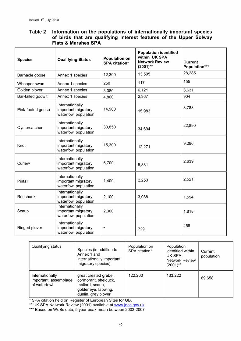
Issued 1st July 2010
40
Table 2 Information on the populations of internationally important species of birds that are qualifying interest features of the Upper Solway Flats & Marshes SPA
Qualifying status
Species (in addition to Annex 1 and internationally important migratory species)
Population on SPA citation*
Population identified within UK SPA Network Review (2001)**
Current population
Internationally important assemblage of waterfowl
great crested grebe, cormorant, shelduck, mallard, scaup, goldeneye, lapwing, dunlin, grey plover
122,200
133,222
89,658
* SPA citation held on Register of European Sites for GB. ** UK SPA Network Review (2001) available at www.jncc.gov.uk *** Based on WeBs data, 5 year peak mean between 2003-2007
Species
Qualifying Status
Population on SPA citation*
Population identified within UK SPA Network Review (2001)**
Current Population***
Barnacle goose
Annex 1 species 12,300 13,595 28,285
Whooper swan
Annex 1 species 250 117 155
Golden plover Annex 1 species 3,380 6,121 3,631
Bar-tailed godwit Annex 1 species 4,800 2,367 904
Pink-footed goose
Internationally important migratory waterfowl population
14,900 15,983
8,783
Oystercatcher
Internationally important migratory waterfowl population
33,850 34,694
22,890
Knot
Internationally important migratory waterfowl population
15,300 12,271
9,296
Curlew
Internationally important migratory waterfowl population
6,700 5,881
2,639
Pintail
Internationally important migratory waterfowl population
1,400 2,253
2,521
Redshank Internationally important migratory waterfowl population
2,100 3,088 1,594
Scaup Internationally important migratory waterfowl population
2,300 1,818
Ringed plover
Internationally important migratory waterfowl population
- 729
458
Issued 1st July 2010
41
7 Favourable condition table The favourable condition table is supplied as part of the Regulation 33 advice package provided by Natural England in support of the conservation objectives for the Solway European marine site (Section 6). The favourable condition table is intended to supplement the conservation objectives only in relation to management of established and ongoing activities and future reporting requirements on monitoring the condition of the site and its features. The table does not by itself provide a comprehensive basis on which to assess plans & projects as required under the Habitats Regulations (as amended) but it does provide a basis to inform the scope and nature of any ‘appropriate assessment’ that may be needed. It should be noted that appropriate assessments are, by contrast, a separate activity to condition monitoring, requiring consideration of issues specific to individual plans or projects. Natural England and Scottish Natural Heritage will provide more detailed advice to competent and relevant authorities in England and Scotland respectively, to assess the implications of any given plan or project under the Regulations, where appropriate, at the time a plan or project is being considered. The favourable condition table is the principal source of information that Natural England will use to assess the condition of an interest feature in England and as such comprises indicators of condition. The Habitats Directive requires that member states of the EU report every 6 years on the implementation of measures designed to maintain or restore habitats and species at favourable conservation status. In Scotland, assessment of site condition is conducted for 66% of features (~130 marine features) within a 6 year cycle under a Site Condition Monitoring programme and is based on a predefined set of criteria, but not specifically the Favourable Condition Table provided. On many terrestrial European sites, we know sufficient about the preferred or target condition of qualifying habitats to be able to define measures and associated targets for all attributes to be assessed in condition monitoring. Assessments as to whether individual interest features are in favourable condition will be made against these targets. In European marine sites we know less about habitat condition and find it difficult to specify favourable condition. Individual locations within a single marine habitat category are also all very different, further hampering the identification of generic indicators of condition. Accordingly, in the absence of such information, condition of interest features in European marine sites will be assessed against targets based on the existing conditions, which may need to be established through baseline surveys in many cases. The advice also provides the basis for discussions with management and advisory groups, and as such the attributes and associated measures and targets may be modified over time. The aim is to produce a single agreed set of attributes that will then be monitored in order to report on the condition of features. Monitoring of the attributes may be of fairly coarse methodology, underpinned by more rigorous methods on specific areas within the site. To meet UK agreed common standards, Natural England will be committed to reporting on each of the attributes subsequently listed in the final version of the table, although the information to be used may be collected by other organisations through agreements. The table is an important, but not the only, driver of the site condition monitoring programme. Other data, such as results from compliance monitoring and appropriate assessments, will also have an important role in assessing condition. Natural England and Scottish Natural Heritage will be responsible for collating the information required to assess condition and will form a judgement on the condition of each feature within the site, taking into account all available information and using the favourable condition table or equivalent as a guide where appropriate.
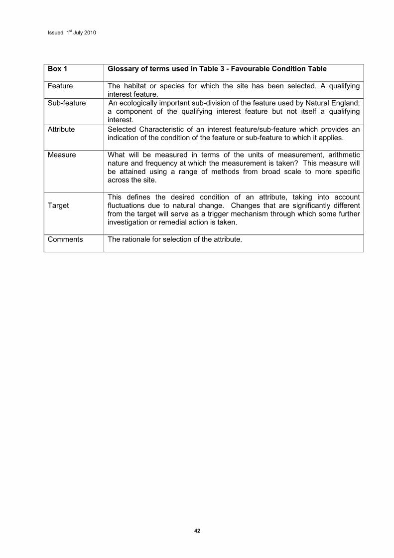
Issued 1st July 2010
42
Box 1 Glossary of terms used in Table 3 - Favourable Condition Table
Feature
The habitat or species for which the site has been selected. A qualifying interest feature.
Sub-feature An ecologically important sub-division of the feature used by Natural England; a component of the qualifying interest feature but not itself a qualifying interest.
Attribute
Selected Characteristic of an interest feature/sub-feature which provides an indication of the condition of the feature or sub-feature to which it applies.
Measure What will be measured in terms of the units of measurement, arithmetic nature and frequency at which the measurement is taken? This measure will be attained using a range of methods from broad scale to more specific across the site.
Target
This defines the desired condition of an attribute, taking into account fluctuations due to natural change. Changes that are significantly different from the target will serve as a trigger mechanism through which some further investigation or remedial action is taken.
Comments The rationale for selection of the attribute.
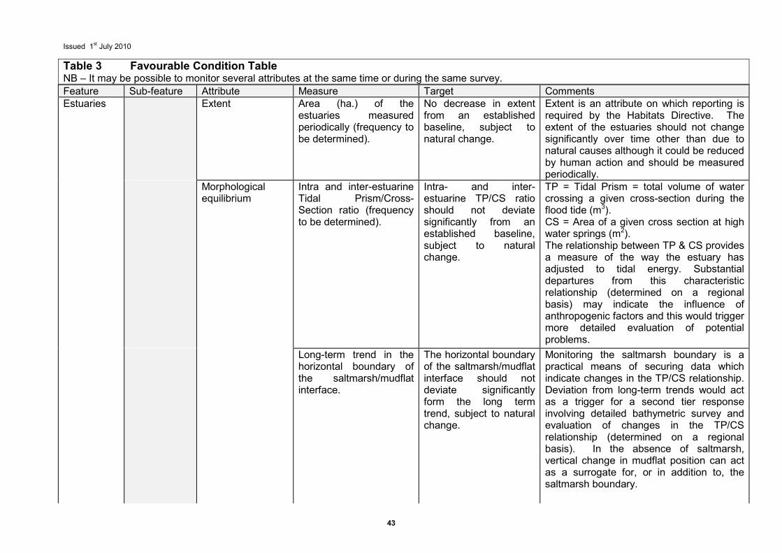
Issued 1st July 2010
43
Feature Sub-feature Attribute Measure Target Comments Estuaries Extent Area (ha.) of the
estuaries measured periodically (frequency to be determined).
No decrease in extent from an established baseline, subject to natural change.
Extent is an attribute on which reporting is required by the Habitats Directive. The extent of the estuaries should not change significantly over time other than due to natural causes although it could be reduced by human action and should be measured periodically.
Morphological equilibrium
Intra and inter-estuarine Tidal Prism/Cross-Section ratio (frequency to be determined).
Intra- and inter-estuarine TP/CS ratio should not deviate significantly from an established baseline, subject to natural change.
TP = Tidal Prism = total volume of water crossing a given cross-section during the flood tide (m3). CS = Area of a given cross section at high water springs (m2). The relationship between TP & CS provides a measure of the way the estuary has adjusted to tidal energy. Substantial departures from this characteristic relationship (determined on a regional basis) may indicate the influence of anthropogenic factors and this would trigger more detailed evaluation of potential problems.
Long-term trend in the horizontal boundary of the saltmarsh/mudflat interface.
The horizontal boundary of the saltmarsh/mudflat interface should not deviate significantly form the long term trend, subject to natural change.
Monitoring the saltmarsh boundary is a practical means of securing data which indicate changes in the TP/CS relationship. Deviation from long-term trends would act as a trigger for a second tier response involving detailed bathymetric survey and evaluation of changes in the TP/CS relationship (determined on a regional basis). In the absence of saltmarsh, vertical change in mudflat position can act as a surrogate for, or in addition to, the saltmarsh boundary.
Table 3 Favourable Condition Table NB – It may be possible to monitor several attributes at the same time or during the same survey.
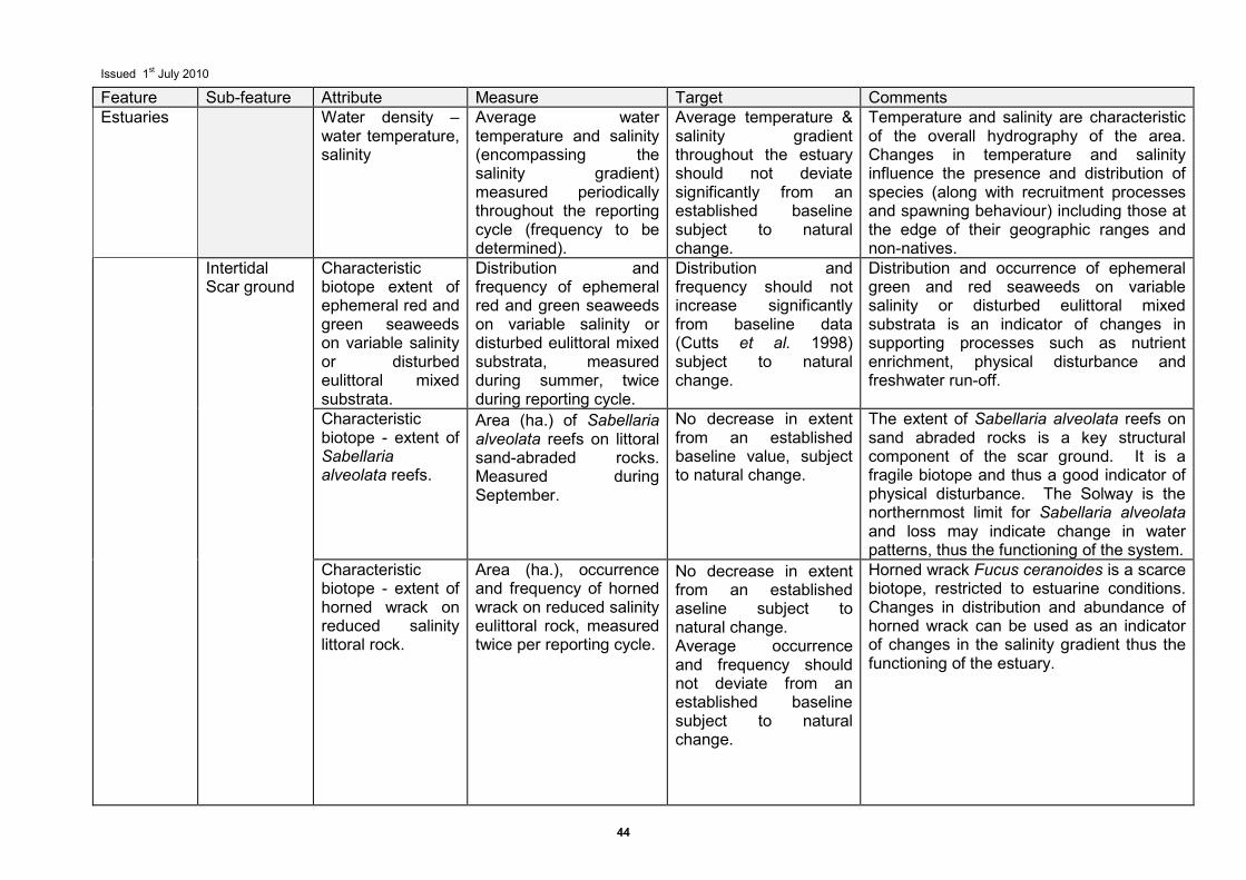
Issued 1st July 2010
44
Feature Sub-feature Attribute Measure Target Comments Estuaries Water density –
water temperature, salinity
Average water temperature and salinity (encompassing the salinity gradient) measured periodically throughout the reporting cycle (frequency to be determined).
Average temperature & salinity gradient throughout the estuary should not deviate significantly from an established baseline subject to natural change.
Temperature and salinity are characteristic of the overall hydrography of the area. Changes in temperature and salinity influence the presence and distribution of species (along with recruitment processes and spawning behaviour) including those at the edge of their geographic ranges and non-natives.
Intertidal Scar ground
Characteristic biotope extent of ephemeral red and green seaweeds on variable salinity or disturbed eulittoral mixed substrata.
Distribution and frequency of ephemeral red and green seaweeds on variable salinity or disturbed eulittoral mixed substrata, measured during summer, twice during reporting cycle.
Distribution and frequency should not increase significantly from baseline data (Cutts et al. 1998) subject to natural change.
Distribution and occurrence of ephemeral green and red seaweeds on variable salinity or disturbed eulittoral mixed substrata is an indicator of changes in supporting processes such as nutrient enrichment, physical disturbance and freshwater run-off.
Characteristic biotope - extent of Sabellaria alveolata reefs.
Area (ha.) of Sabellaria alveolata reefs on littoral sand-abraded rocks. Measured during September.
No decrease in extent from an established baseline value, subject to natural change.
The extent of Sabellaria alveolata reefs on sand abraded rocks is a key structural component of the scar ground. It is a fragile biotope and thus a good indicator of physical disturbance. The Solway is the northernmost limit for Sabellaria alveolata and loss may indicate change in water patterns, thus the functioning of the system.
Characteristic biotope - extent of horned wrack on reduced salinity littoral rock.
Area (ha.), occurrence and frequency of horned wrack on reduced salinity eulittoral rock, measured twice per reporting cycle.
No decrease in extent from an established aseline subject to natural change. Average occurrence and frequency should not deviate from an established baseline subject to natural change.
Horned wrack Fucus ceranoides is a scarce biotope, restricted to estuarine conditions. Changes in distribution and abundance of horned wrack can be used as an indicator of changes in the salinity gradient thus the functioning of the estuary.
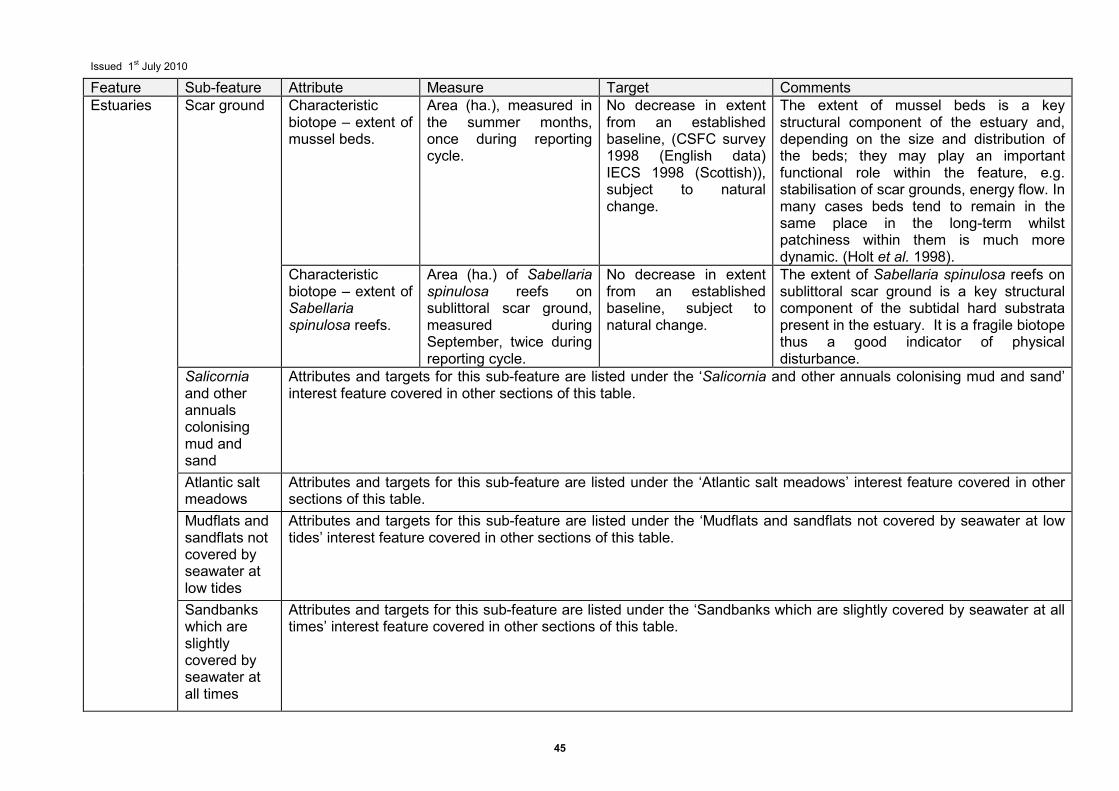
Issued 1st July 2010
45
Feature Sub-feature Attribute Measure Target Comments Estuaries Scar ground Characteristic
biotope – extent of mussel beds.
Area (ha.), measured in the summer months, once during reporting cycle.
No decrease in extent from an established baseline, (CSFC survey 1998 (English data) IECS 1998 (Scottish)), subject to natural change.
The extent of mussel beds is a key structural component of the estuary and, depending on the size and distribution of the beds; they may play an important functional role within the feature, e.g. stabilisation of scar grounds, energy flow. In many cases beds tend to remain in the same place in the long-term whilst patchiness within them is much more dynamic. (Holt et al. 1998).
Characteristic biotope – extent of Sabellaria spinulosa reefs.
Area (ha.) of Sabellaria spinulosa reefs on sublittoral scar ground, measured during September, twice during reporting cycle.
No decrease in extent from an established baseline, subject to natural change.
The extent of Sabellaria spinulosa reefs on sublittoral scar ground is a key structural component of the subtidal hard substrata present in the estuary. It is a fragile biotope thus a good indicator of physical disturbance.
Salicornia and other annuals colonising mud and sand
Attributes and targets for this sub-feature are listed under the ‘Salicornia and other annuals colonising mud and sand’ interest feature covered in other sections of this table.
Atlantic salt meadows
Attributes and targets for this sub-feature are listed under the ‘Atlantic salt meadows’ interest feature covered in other sections of this table.
Mudflats and sandflats not covered by seawater at low tides
Attributes and targets for this sub-feature are listed under the ‘Mudflats and sandflats not covered by seawater at low tides’ interest feature covered in other sections of this table.
Sandbanks which are slightly covered by seawater at all times
Attributes and targets for this sub-feature are listed under the ‘Sandbanks which are slightly covered by seawater at all times’ interest feature covered in other sections of this table.
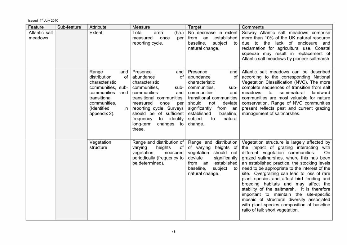
Issued 1st July 2010
46
Feature Sub-feature Attribute Measure Target Comments Atlantic salt meadows
Extent Total area (ha.) measured once per reporting cycle.
No decrease in extent from an established baseline, subject to natural change.
Solway Atlantic salt meadows comprise more than 10% of the UK natural resource due to the lack of enclosure and reclamation for agricultural use. Coastal squeeze may result in replacement of Atlantic salt meadows by pioneer saltmarsh
Range and distribution of characteristic communities, sub-communities and transitional communities. (Identified in appendix 2).
Presence and abundance of characteristic communities, sub-communities and transitional communities, measured once per reporting cycle. Surveys should be of sufficient frequency to identify long-term changes to these.
Presence and abundance of characteristic communities, sub-communities and transitional communities should not deviate significantly from an established baseline, subject to natural change.
Atlantic salt meadows can be described according to the corresponding National Vegetation Classification (NVC). The more complete sequences of transition from salt meadows to semi-natural landward communities are most valuable for nature conservation. Range of NVC communities present reflects past and current grazing management of saltmarshes.
Vegetation structure
Range and distribution of varying heights of vegetation, measured periodically (frequency to be determined).
Range and distribution of varying heights of vegetation should not deviate significantly from an established baseline, subject to natural change.
Vegetation structure is largely affected by the impact of grazing interacting with different vegetation communities. On grazed saltmarshes, where this has been an established practice, the stocking levels need to be appropriate to the interest of the site. Overgrazing can lead to loss of rare plant species and affect bird feeding and breeding habitats and may affect the stability of the saltmarsh. It is therefore important to maintain the site-specific mosaic of structural diversity associated with plant species composition at baseline ratio of tall: short vegetation.
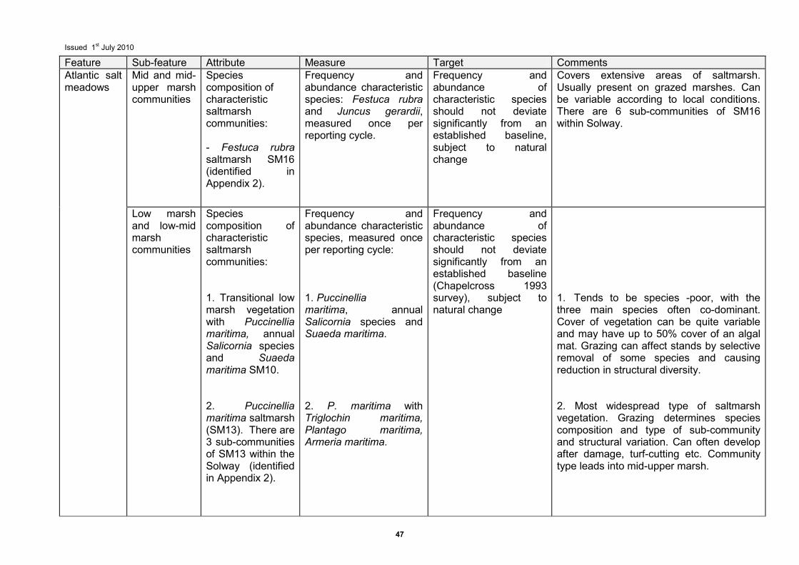
Issued 1st July 2010
47
Feature Sub-feature Attribute Measure Target Comments Atlantic salt meadows
Mid and mid-upper marsh communities
Species composition of characteristic saltmarsh communities: - Festuca rubra saltmarsh SM16 (identified in Appendix 2).
Frequency and abundance characteristic species: Festuca rubra and Juncus gerardii, measured once per reporting cycle.
Frequency and abundance of characteristic species should not deviate significantly from an established baseline, subject to natural change
Covers extensive areas of saltmarsh. Usually present on grazed marshes. Can be variable according to local conditions. There are 6 sub-communities of SM16 within Solway.
Low marsh and low-mid marsh communities
Species composition of characteristic saltmarsh communities: 1. Transitional low marsh vegetation with Puccinellia maritima, annual Salicornia species and Suaeda maritima SM10. 2. Puccinellia maritima saltmarsh (SM13). There are 3 sub-communities of SM13 within the Solway (identified in Appendix 2).
Frequency and abundance characteristic species, measured once per reporting cycle: 1. Puccinellia maritima, annual Salicornia species and Suaeda maritima. 2. P. maritima with Triglochin maritima, Plantago maritima, Armeria maritima.
Frequency and abundance of characteristic species should not deviate significantly from an established baseline (Chapelcross 1993 survey), subject to natural change
1. Tends to be species -poor, with the three main species often co-dominant. Cover of vegetation can be quite variable and may have up to 50% cover of an algal mat. Grazing can affect stands by selective removal of some species and causing reduction in structural diversity. 2. Most widespread type of saltmarsh vegetation. Grazing determines species composition and type of sub-community and structural variation. Can often develop after damage, turf-cutting etc. Community type leads into mid-upper marsh.
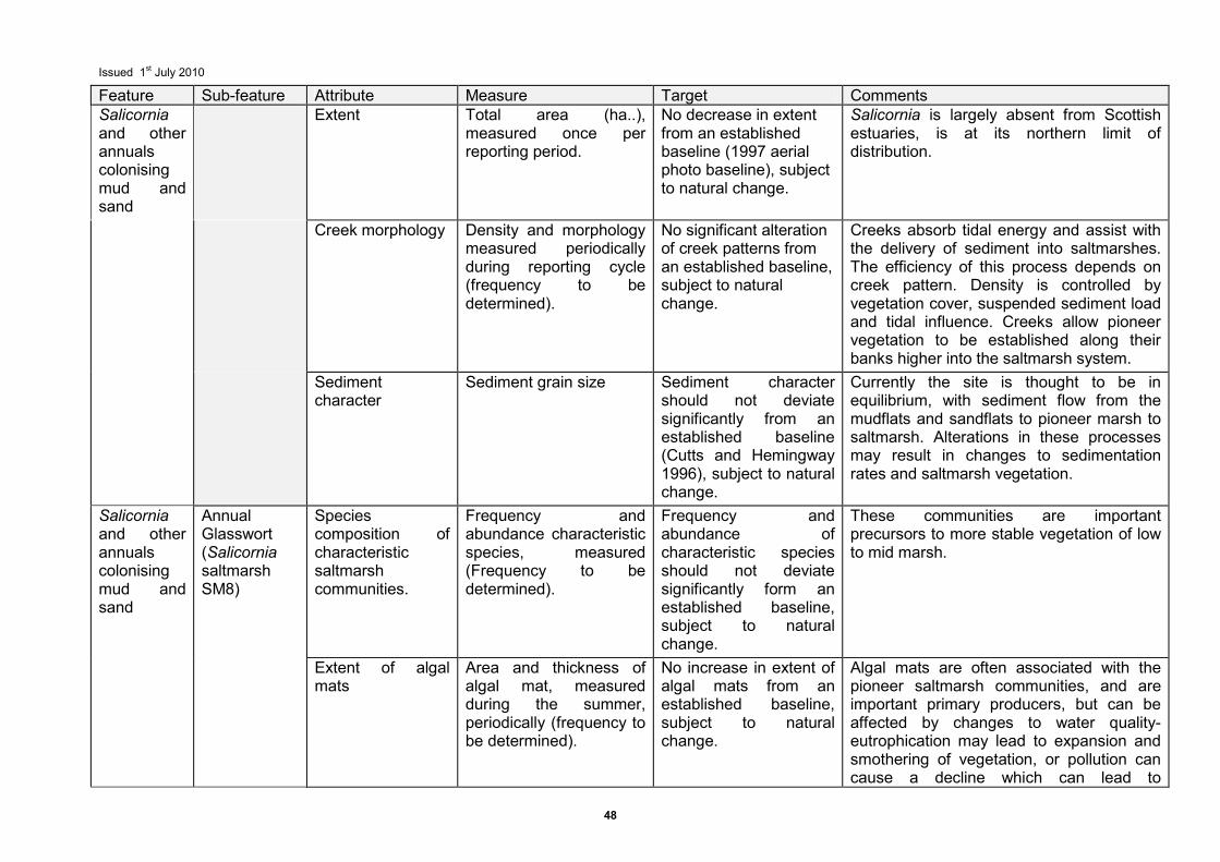
Issued 1st July 2010
48
Feature Sub-feature Attribute Measure Target Comments Salicornia and other annuals colonising mud and sand
Extent
Total area (ha..), measured once per reporting period.
No decrease in extent from an established baseline (1997 aerial photo baseline), subject to natural change.
Salicornia is largely absent from Scottish estuaries, is at its northern limit of distribution.
Creek morphology Density and morphology measured periodically during reporting cycle (frequency to be determined).
No significant alteration of creek patterns from an established baseline, subject to natural change.
Creeks absorb tidal energy and assist with the delivery of sediment into saltmarshes. The efficiency of this process depends on creek pattern. Density is controlled by vegetation cover, suspended sediment load and tidal influence. Creeks allow pioneer vegetation to be established along their banks higher into the saltmarsh system.
Sediment character
Sediment grain size Sediment character should not deviate significantly from an established baseline (Cutts and Hemingway 1996), subject to natural change.
Currently the site is thought to be in equilibrium, with sediment flow from the mudflats and sandflats to pioneer marsh to saltmarsh. Alterations in these processes may result in changes to sedimentation rates and saltmarsh vegetation.
Salicornia and other annuals colonising mud and sand
Annual Glasswort (Salicornia saltmarsh SM8)
Species composition of characteristic saltmarsh communities.
Frequency and abundance characteristic species, measured (Frequency to be determined).
Frequency and abundance of characteristic species should not deviate significantly form an established baseline, subject to natural change.
These communities are important precursors to more stable vegetation of low to mid marsh.
Extent of algal mats
Area and thickness of algal mat, measured during the summer, periodically (frequency to be determined).
No increase in extent of algal mats from an established baseline, subject to natural change.
Algal mats are often associated with the pioneer saltmarsh communities, and are important primary producers, but can be affected by changes to water quality- eutrophication may lead to expansion and smothering of vegetation, or pollution can cause a decline which can lead to
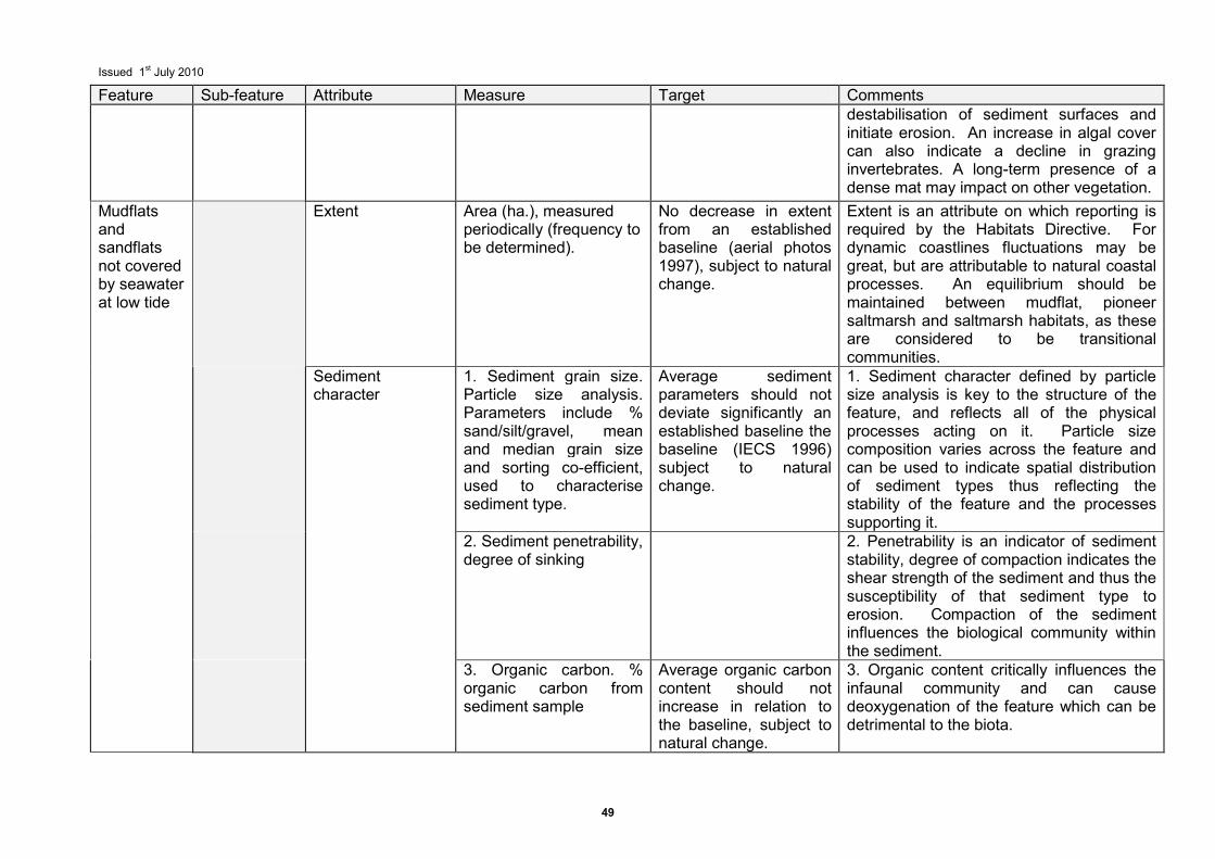
Issued 1st July 2010
49
Feature Sub-feature Attribute Measure Target Comments destabilisation of sediment surfaces and initiate erosion. An increase in algal cover can also indicate a decline in grazing invertebrates. A long-term presence of a dense mat may impact on other vegetation.
Mudflats and sandflats not covered by seawater at low tide
Extent Area (ha.), measured periodically (frequency to be determined).
No decrease in extent from an established baseline (aerial photos 1997), subject to natural change.
Extent is an attribute on which reporting is required by the Habitats Directive. For dynamic coastlines fluctuations may be great, but are attributable to natural coastal processes. An equilibrium should be maintained between mudflat, pioneer saltmarsh and saltmarsh habitats, as these are considered to be transitional communities.
Sediment character
1. Sediment grain size. Particle size analysis. Parameters include % sand/silt/gravel, mean and median grain size and sorting co-efficient, used to characterise sediment type.
Average sediment parameters should not deviate significantly an established baseline the baseline (IECS 1996) subject to natural change.
1. Sediment character defined by particle size analysis is key to the structure of the feature, and reflects all of the physical processes acting on it. Particle size composition varies across the feature and can be used to indicate spatial distribution of sediment types thus reflecting the stability of the feature and the processes supporting it.
2. Sediment penetrability, degree of sinking
2. Penetrability is an indicator of sediment stability, degree of compaction indicates the shear strength of the sediment and thus the susceptibility of that sediment type to erosion. Compaction of the sediment influences the biological community within the sediment.
3. Organic carbon. % organic carbon from sediment sample
Average organic carbon content should not increase in relation to the baseline, subject to natural change.
3. Organic content critically influences the infaunal community and can cause deoxygenation of the feature which can be detrimental to the biota.
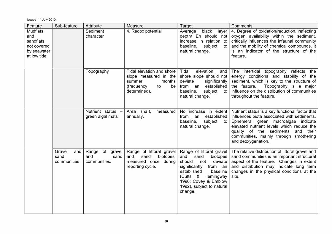
Issued 1st July 2010
50
Feature Sub-feature Attribute Measure Target Comments Mudflats and sandflats not covered by seawater at low tide
Sediment character
4. Redox potential Average black layer depth/ Eh should not increase in relation to baseline, subject to natural change.
4. Degree of oxidation/reduction, reflecting oxygen availability within the sediment, critically influences the infaunal community and the mobility of chemical compounds. It is an indicator of the structure of the feature.
Topography Tidal elevation and shore slope measured in the summer months (frequency to be determined).
Tidal elevation and shore slope should not deviate significantly from an established baseline, subject to natural change.
The intertidal topography reflects the energy conditions and stability of the sediment, which is key to the structure of the feature. Topography is a major influence on the distribution of communities throughout the feature.
Nutrient status – green algal mats
Area (ha.), measured annually.
No increase in extent from an established baseline, subject to natural change.
Nutrient status is a key functional factor that influences biota associated with sediments. Ephemeral green macroalgae indicate elevated nutrient levels which reduce the quality of the sediments and their communities, mainly through smothering and deoxygenation.
Gravel and sand communities
Range of gravel and sand communities.
Range of littoral gravel and sand biotopes, measured once during reporting cycle.
Range of littoral gravel and sand biotopes should not deviate significantly from an established baseline (Cutts & Hemingway 1996; Covey & Emblow 1992), subject to natural change.
The relative distribution of littoral gravel and sand communities is an important structural aspect of the feature. Changes in extent and distribution may indicate long term changes in the physical conditions at the site.
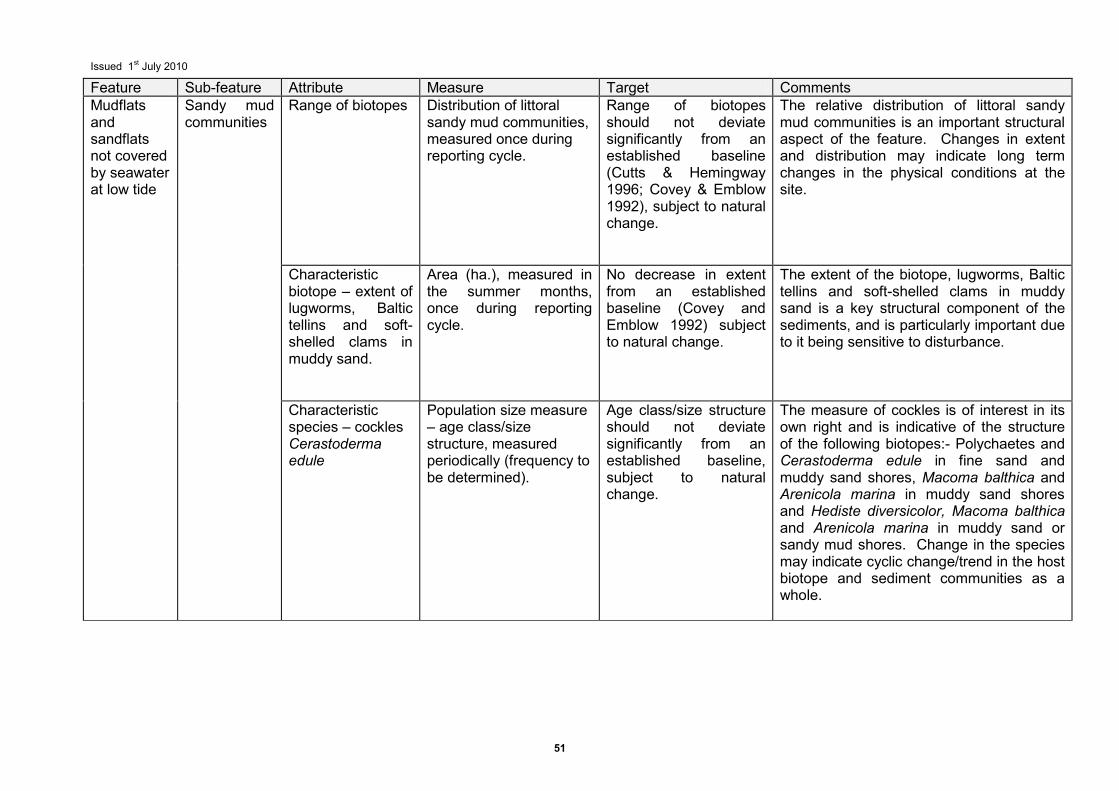
Issued 1st July 2010
51
Feature Sub-feature Attribute Measure Target Comments Mudflats and sandflats not covered by seawater at low tide
Sandy mud communities
Range of biotopes
Distribution of littoral sandy mud communities, measured once during reporting cycle.
Range of biotopes should not deviate significantly from an established baseline (Cutts & Hemingway 1996; Covey & Emblow 1992), subject to natural change.
The relative distribution of littoral sandy mud communities is an important structural aspect of the feature. Changes in extent and distribution may indicate long term changes in the physical conditions at the site.
Characteristic biotope – extent of lugworms, Baltic tellins and soft-shelled clams in muddy sand.
Area (ha.), measured in the summer months, once during reporting cycle.
No decrease in extent from an established baseline (Covey and Emblow 1992) subject to natural change.
The extent of the biotope, lugworms, Baltic tellins and soft-shelled clams in muddy sand is a key structural component of the sediments, and is particularly important due to it being sensitive to disturbance.
Characteristic species – cockles Cerastoderma edule
Population size measure – age class/size structure, measured periodically (frequency to be determined).
Age class/size structure should not deviate significantly from an established baseline, subject to natural change.
The measure of cockles is of interest in its own right and is indicative of the structure of the following biotopes:- Polychaetes and Cerastoderma edule in fine sand and muddy sand shores, Macoma balthica and Arenicola marina in muddy sand shores and Hediste diversicolor, Macoma balthica and Arenicola marina in muddy sand or sandy mud shores. Change in the species may indicate cyclic change/trend in the host biotope and sediment communities as a whole.
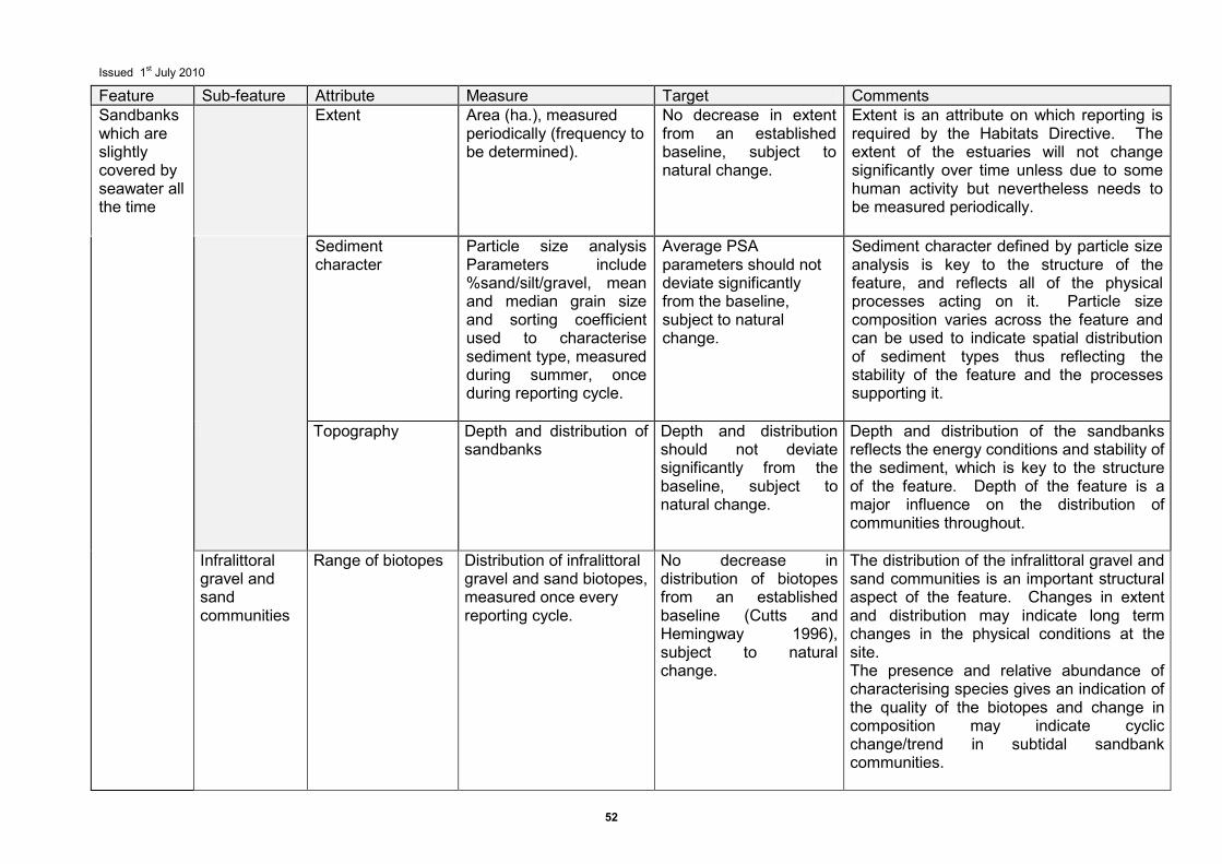
Issued 1st July 2010
52
Feature Sub-feature Attribute Measure Target Comments Sandbanks which are slightly covered by seawater all the time
Extent Area (ha.), measured periodically (frequency to be determined).
No decrease in extent from an established baseline, subject to natural change.
Extent is an attribute on which reporting is required by the Habitats Directive. The extent of the estuaries will not change significantly over time unless due to some human activity but nevertheless needs to be measured periodically.
Sediment character
Particle size analysis Parameters include %sand/silt/gravel, mean and median grain size and sorting coefficient used to characterise sediment type, measured during summer, once during reporting cycle.
Average PSA parameters should not deviate significantly from the baseline, subject to natural change.
Sediment character defined by particle size analysis is key to the structure of the feature, and reflects all of the physical processes acting on it. Particle size composition varies across the feature and can be used to indicate spatial distribution of sediment types thus reflecting the stability of the feature and the processes supporting it.
Topography Depth and distribution of sandbanks
Depth and distribution should not deviate significantly from the baseline, subject to natural change.
Depth and distribution of the sandbanks reflects the energy conditions and stability of the sediment, which is key to the structure of the feature. Depth of the feature is a major influence on the distribution of communities throughout.
Infralittoral gravel and sand communities
Range of biotopes Distribution of infralittoral gravel and sand biotopes, measured once every reporting cycle.
No decrease in distribution of biotopes from an established baseline (Cutts and Hemingway 1996), subject to natural change.
The distribution of the infralittoral gravel and sand communities is an important structural aspect of the feature. Changes in extent and distribution may indicate long term changes in the physical conditions at the site. The presence and relative abundance of characterising species gives an indication of the quality of the biotopes and change in composition may indicate cyclic change/trend in subtidal sandbank communities.

Issued 1st July 2010
53
Feature Sub-feature Attribute Measure Target Comments Reefs
Extent
Extent should be assessed periodically against a baseline map/aerial image or through the review of any known activities that may have caused an alteration in extent. For details of assessment techniques see Davies et al., 2001.
No change in the extent of the biotopes which include SLR.MytX, MLR Salv, allowing for natural succession/ known cyclical change.
Changes in extent would be considered unfavourable if attributable to activities which interrupt natural coastal processes such as coastal protection schemes or coastal development.
Biotope composition of the biogenic reef
Repeated assessment of overall biotope composition. For details of assessment techniques see Davies et al., 2001.
Maintain the variety of biotopes identified for the site, allowing for natural succession or known cyclical change.
Where changes in biotope composition are known to be attributable to natural processes (e.g. winter storm/flood events, changes in supporting processes or mass recruitment or dieback of characterising species) then the target value should accommodate this variability. Where there is a change in biotope composition outside the expected variation or a loss of the conservation interest of the site, then condition should be considered unfavourable.
Distribution of biotopes/ Spatial arrangement of biotopes at specified locations
Assess the geographic distribution of specified biotopes identified for the site. Assess the zonation pattern or the juxtaposition of specified biotopes.
Maintain the distribution and/or spatial arrangement of biotopes, allowing for natural succession/known cyclical change
Where changes in distribution/spatial pattern are known to be clearly attributable to cyclical succession or an expected shift in distribution then the target value should accommodate this variability. Where there is a change in biotope distribution/spatial pattern outside the expected variation or a loss of the conservation interest of the site, then condition should be considered unfavorable.
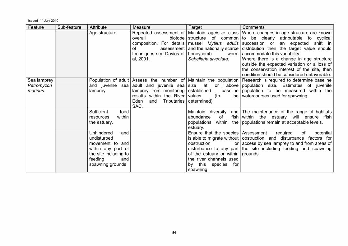
Issued 1st July 2010
54
Feature Sub-feature Attribute Measure Target Comments Age structure Repeated assessment of
overall biotope composition. For details of assessment techniques see Davies et al, 2001.
Maintain age/size class structure of common mussel Mytilus edulis and the nationally scarce honeycomb worm Sabellaria alveolata.
Where changes in age structure are known to be clearly attributable to cyclical succession or an expected shift in distribution then the target value should accommodate this variability. Where there is a change in age structure outside the expected variation or a loss of the conservation interest of the site, then condition should be considered unfavorable.
Sea lamprey Petromyzon marinus
Population of adult and juvenile sea lamprey
Assess the number of adult and juvenile sea lamprey from monitoring results within the River Eden and Tributaries SAC.
Maintain the population size at or above established baseline values (to be determined)
Research is required to determine baseline population size. Estimates of juvenile population to be measured within the watercourses used for spawning
Sufficient food resources within the estuary.
Maintain diversity and abundance of fish populations within the estuary.
The maintenance of the range of habitats within the estuary will ensure fish populations remain at acceptable levels.
Unhindered and undisturbed movement to and within any part of the site including to feeding and spawning grounds
Ensure that the species is able to migrate without obstruction or disturbance to any part of the estuary or within the river channels used by this species for spawning
Assessment required of potential obstruction and disturbance factors for access by sea lamprey to and from areas of the site including feeding and spawning grounds.
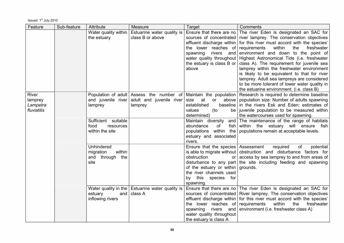
Issued 1st July 2010
55
Feature Sub-feature Attribute Measure Target Comments Water quality within
the estuary Estuarine water quality is class B or above
Ensure that there are no sources of concentrated effluent discharge within the lower reaches of spawning rivers and water quality throughout the estuary is class B or above
The river Eden is designated an SAC for river lamprey. The conservation objectives for this river must accord with the species’ requirements within the freshwater environment and down to the point of Highest Astronomical Tide (i.e. freshwater class A). The requirement for juvenile sea lamprey within the freshwater environment is likely to be equivalent to that for river lamprey. Adult sea lampreys are considered to be more tolerant of lower water quality in the estuarine environment. (i.e. class B)
River lamprey Lampetra fluviatilis
Population of adult and juvenile river lamprey
Assess the number of adult and juvenile river lamprey
Maintain the population size at or above established baseline values (to be determined)
Research is required to determine baseline population size: Number of adults spawning in the rivers Esk and Eden; estimates of juvenile population to be measured within the watercourses used for spawning.
Sufficient suitable food resources within the site
Maintain diversity and abundance of fish populations within the estuary and associated rivers.
The maintenance of the range of habitats within the estuary will ensure fish populations remain at acceptable levels.
Unhindered migration within and through the site
Ensure that the species is able to migrate without obstruction or disturbance to any part of the estuary or within the river channels used by this species for spawning.
Assessment required of potential obstruction and disturbance factors for access by sea lamprey to and from areas of the site including feeding and spawning grounds.
Water quality in the estuary and inflowing rivers
Estuarine water quality is class A
Ensure that there are no sources of concentrated effluent discharge within the lower reaches of spawning rivers and water quality throughout the estuary is class A
The river Eden is designated an SAC for River lamprey. The conservation objectives for this river must accord with the species’ requirements within the freshwater environment (i.e. freshwater class A)
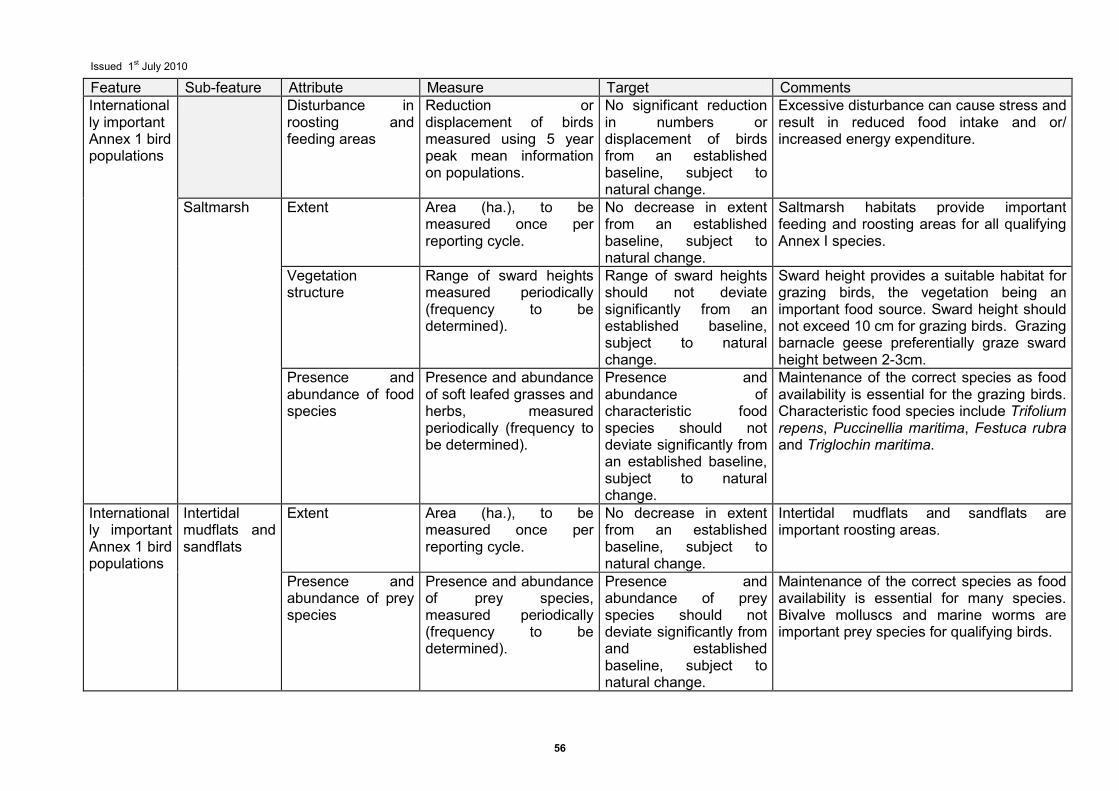
Issued 1st July 2010
56
Feature Sub-feature Attribute Measure Target Comments Internationally important Annex 1 bird populations
Disturbance in roosting and feeding areas
Reduction or displacement of birds measured using 5 year peak mean information on populations.
No significant reduction in numbers or displacement of birds from an established baseline, subject to natural change.
Excessive disturbance can cause stress and result in reduced food intake and or/ increased energy expenditure.
Saltmarsh Extent Area (ha.), to be measured once per reporting cycle.
No decrease in extent from an established baseline, subject to natural change.
Saltmarsh habitats provide important feeding and roosting areas for all qualifying Annex I species.
Vegetation structure
Range of sward heights measured periodically (frequency to be determined).
Range of sward heights should not deviate significantly from an established baseline, subject to natural change.
Sward height provides a suitable habitat for grazing birds, the vegetation being an important food source. Sward height should not exceed 10 cm for grazing birds. Grazing barnacle geese preferentially graze sward height between 2-3cm.
Presence and abundance of food species
Presence and abundance of soft leafed grasses and herbs, measured periodically (frequency to be determined).
Presence and abundance of characteristic food species should not deviate significantly from an established baseline, subject to natural change.
Maintenance of the correct species as food availability is essential for the grazing birds. Characteristic food species include Trifolium repens, Puccinellia maritima, Festuca rubra and Triglochin maritima.
Internationally important Annex 1 bird populations
Intertidal mudflats and sandflats
Extent Area (ha.), to be measured once per reporting cycle.
No decrease in extent from an established baseline, subject to natural change.
Intertidal mudflats and sandflats are important roosting areas.
Presence and abundance of prey species
Presence and abundance of prey species, measured periodically (frequency to be determined).
Presence and abundance of prey species should not deviate significantly from and established baseline, subject to natural change.
Maintenance of the correct species as food availability is essential for many species. Bivalve molluscs and marine worms are important prey species for qualifying birds.

Issued 1st July 2010
57
Feature Sub-feature Attribute Measure Target Comments Internationally important migratory waterfowl
Disturbance in roosting and feeding areas
Reduction or displacement of birds measured using 5 year peak mean information on populations.
No significant reduction in numbers or displacement of birds from an established baseline subject to natural change.
Excessive disturbance can cause stress and result in reduced food intake and or/ increased energy expenditure.
Saltmarsh Extent Area (ha.), to be measured once per reporting cycle.
No decrease in extent from an established baseline, subject to natural change.
Saltmarsh habitats are important feeding and roosting grounds for a number of bird species.
Internationally important assemblage
Saltmarsh Vegetation structure
Range of sward heights measured periodically (frequency to be determined).
Range of sward heights should not deviate significantly from and established baseline, subject to natural change.
Varying sward heights provide suitable habitats for grazing birds, the vegetation being an important food source. A diverse range of sward heights will also provide cover for birds taking refuge, as well as providing suitable nesting areas. Sward height should be tailored to suit a range of grazing birds. Varying heights are preferentially grazed by different species.
Rocky scar grounds
Extent Area (ha.), to be measured once per reporting cycle.
No decrease in extent from baseline, subject to natural change.
Rocky scar grounds are important feeding areas for a number of bird species.
Presence and abundance of prey species
Presence and abundance of prey species, measured periodically (frequency to be determined).
Presence and abundance of prey species should not deviate significantly from an established baseline, subject to natural change
Rocky scar grounds are important feeding areas for a number of bird species.
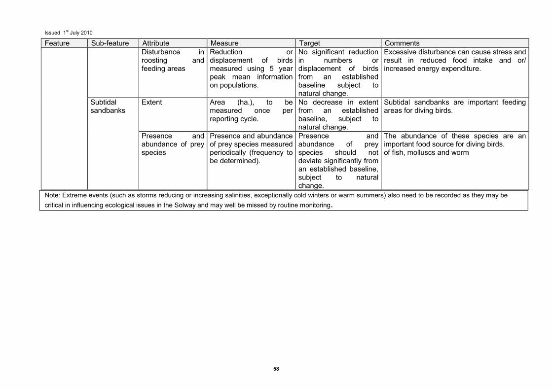
Issued 1st July 2010
58
Feature Sub-feature Attribute Measure Target Comments Disturbance in
roosting and feeding areas
Reduction or displacement of birds measured using 5 year peak mean information on populations.
No significant reduction in numbers or displacement of birds from an established baseline subject to natural change.
Excessive disturbance can cause stress and result in reduced food intake and or/ increased energy expenditure.
Subtidal sandbanks
Extent Area (ha.), to be measured once per reporting cycle.
No decrease in extent from an established baseline, subject to natural change.
Subtidal sandbanks are important feeding areas for diving birds.
Presence and abundance of prey species
Presence and abundance of prey species measured periodically (frequency to be determined).
Presence and abundance of prey species should not deviate significantly from an established baseline, subject to natural change.
The abundance of these species are an important food source for diving birds. of fish, molluscs and worm
Note: Extreme events (such as storms reducing or increasing salinities, exceptionally cold winters or warm summers) also need to be recorded as they may be
critical in influencing ecological issues in the Solway and may well be missed by routine monitoring.
Issued 1st July 2010
59
8 Introduction to the advice on operations This section includes information in support of the advice required under Regulation 33(2)(b). Natural England and Scottish Natural Heritage have a duty under Regulation 33(2)(b) of the Conservation (Natural Habitats &c.) Regulations 1994 (as amended) to advise other relevant authorities as to any operations which may cause deterioration of natural habitats or the habitats of species, or disturbance of species, for which the site has been designated. Information on how this advice has been developed is given in Section 8.2, and on how it may be reviewed and updated in the future, in Section 8.4. 8.1 Purpose of advice The aim of this advice is to enable relevant authorities to direct and prioritise their work on the management of activities that pose the greatest potential threat to the favourable condition of interest features on the Solway European marine site. The advice is linked to the conservation objectives for interest features and, will help provide the basic information to enable the management group to formulate or review and agree a management scheme to agreed timescales for the site. The advice given here will inform on, but is without prejudice to, any advice to be given subsequently under Regulation 48 or Regulation 50 on operations that qualify as plans or projects within the meaning of Article 6 of the Habitats Directive. 8.2 Methods for assessment To develop this advice on operations a three step process has been used involving: • an assessment of sensitivity of the interest features or their component sub-features to
operations;
• an assessment of the exposure of each interest feature or their component sub-features to operations; and
• a final assessment of current vulnerability of interest features or their component sub-features to operations.
This three step process builds up a level of information necessary to manage activities in and around the European marine site in an effective manner. Through a consistent approach, this process enables an explanation of the reasoning behind the advice and identifies to competent and relevant authorities those current operations which pose the greatest threat to the favourable condition of the interest features of the European marine site. All the scores of relative sensitivity, exposure and vulnerability are derived using best available scientific information and informed scientific interpretation and judgement. The process uses sufficiently coarse categorisation to minimise uncertainty in information, reflecting the current state of our knowledge and understanding of the marine environment. 8.2.1 Sensitivity assessment The sensitivity assessments of the interest features or their component sub-features of the Solway European marine site were originally based upon a series of scientific review documents. These included reports produced for the UK Marine SAC LIFE project (Elliott et al. 1998), and the Countryside Council for Wales Science Report (Holt et al. 1995). Natural England and Scottish Natural Heritage commissioned the Marine Biological Association of the UK, through its Marine Life Information Network (MarLIN) to provide detailed sensitivity
Issued 1st July 2010
60
information to underpin this advice. The MarLIN sensitivity assessment rationale, definitions of terms and scales used prior to March 2003 are given by Tyler-Walters et al. (2001) and their development in Tyler-Walters & Jackson (1999) and Hiscock et al. (1999). The definition of sensitivity was revised in March 2003 based on the definition suggested by the RMNC (Laffoley et al., 2000) and further developed by MarLIN. This information is available on the Marlin website www.marlin.ac.uk. The sensitivity assessment used examines the relative sensitivity of the interest features or the component sub-features of the Solway Firth European marine site to the effects of broad categories of human activities. 'Sensitivity' is dependent on the intolerance of a species or habitat to damage from an external factor and the time taken for its subsequent recovery. For example, a very sensitive species or habitat is one that is very adversely affected by an external factor arising from human activities or natural events (killed/destroyed, 'high' intolerance) and is expected to recover over a very long period of time, i.e. >10 or up to 25 years ('low'; recoverability). Intolerance and hence sensitivity must be assessed relative to change in a specific factor (MarLIN 2003). As an example, saltmarshes are highly sensitive to coastal defences as these prevent their natural inward migration. 8.2.2 Exposure assessment This has been undertaken for the Solway European marine site by assessing the relative exposure of the interests or their component sub-features on the site to the effects of broad categories of human activities currently occurring on the site. For example some stretches of the site have a relatively high exposure to nutrient enrichment from diffuse land run off, in particular around Moricambe Bay on the Cumbrian coast, which drains areas of extensively farmed land. The existing features were assessed in 2000 for the original advice, although the features added within this interim guidance (i.e. Reef, Sea Lamprey and River Lamprey) were assessed at levels present in 2008. 8.2.3 Vulnerability assessment The third step in the process is to determine the vulnerability of interest features or their component sub-features to operations. This is an integration of sensitivity and exposure. Only if a feature is both sensitive and exposed to a human activity will it be considered vulnerable. In this context therefore, ‘vulnerability’ has been defined as the exposure of a habitat, community or individual (or individual colony) of a species to an external factor to which it is sensitive (Hiscock 1996). For example a subtidal sandbank may be sensitive to abrasion by benthic fishing gear, but it may not be currently vulnerable within the Solway due to the limited benthic fishing taking place and existing management controls. The process of deriving and scoring relative vulnerability is provided in Appendix I. 8.3 Format of advice The advice is provided within six broad categories of operations which may cause deterioration of natural habitats or the habitats of species, or disturbance of species. These are: physical loss; physical damage; non-physical disturbance; toxic contamination; non-toxic contamination and biological disturbance. This approach therefore:
• enables links to be made between human activities and the ecological requirements of
the habitats or species, as required under Article 6 of the Habitats Directive; • provides a consistent framework to enable relevant authorities to assess the effects of
activities and identify priorities for management within their areas of responsibility; and
Issued 1st July 2010
61
is appropriately robust to take into account the development of novel activities or operations which may cause deterioration or disturbance to the interest features of the site and should have sufficient stability to need only infrequent review and updating by Natural England and Scottish Natural Heritage.
These broad categories provide a clear framework against which relevant authorities can assess activities under their responsibility. The more detailed information in Table 5 provides relevant authorities with a context against which to consider an assessment of ‘significant effect’ for any plans or projects which may affect the site and a basis to inform on the scope and nature of appropriate assessments required in relation to plans and projects. It is important to note that this advice is only a starting point for assessing impacts. It does not remove the need for the relevant authorities to formally consult Natural England or Scottish Natural Heritage over individual plans and projects where required to do so under the Regulations. 8.4 Update and review of advice Information as to the operations which may cause deterioration of natural habitats or the habitats of species, or disturbance of species, for which the site has been designated, is provided in light of what Natural England and Scottish Natural Heritage know about current activities and patterns of usage at the Solway European marine site. It is expected that the information on current activities and patterns of usage (which was used to derive Table 4) will be refined as part of the process of developing or updating the management scheme through further discussion with the relevant authorities. The option of zoning this information may be appropriate. As such, it is important that future consideration of this advice by relevant authorities and others takes account of changes in the usage patterns that have occurred at the site, over the intervening period, since the advice was issued. In contrast, the information provided in this advice on the vulnerability of interest features or sub-features (Table 5) is relatively stable and will only change as a result of an improvement in our scientific knowledge, which will be a relatively long term process. Advice for sites will be kept under review and may be periodically updated through discussions with relevant authorities and others to reflect significant changes in our understanding of sensitivity together with the potential effects of plans and projects on the marine environment.
Issued 1st July 2010
62
9 Advice on operations
This section is provided in compliance with Regulation 33(2)(b) of the Conservation (Natural Habitats &c.) Regulations 1994 (as amended)
9.1 Summary of advice on operations In pursuit of the conservation objectives for the site as stated in Section 6, the relevant and competent authorities for the Solway Firth European marine site are advised to manage human activities within their remit such that they do not result in deterioration or disturbance to habitats or species for which the site has been selected, through any of the following: • Physical loss through removal or smothering • Physical damage through siltation and/or abrasion and/or selective extraction • Non-physical disturbance – visual/noise • Toxic contamination –introduction of synthetic, non-synthetic toxic and/or radionuclide
contamination • Non-toxic contamination - nutrient and/or organic enrichment; changes is turbidity, salinity
or thermal regime • Biological disturbance - the introduction of non-native species and/or translocation and/or
the selective extraction of species
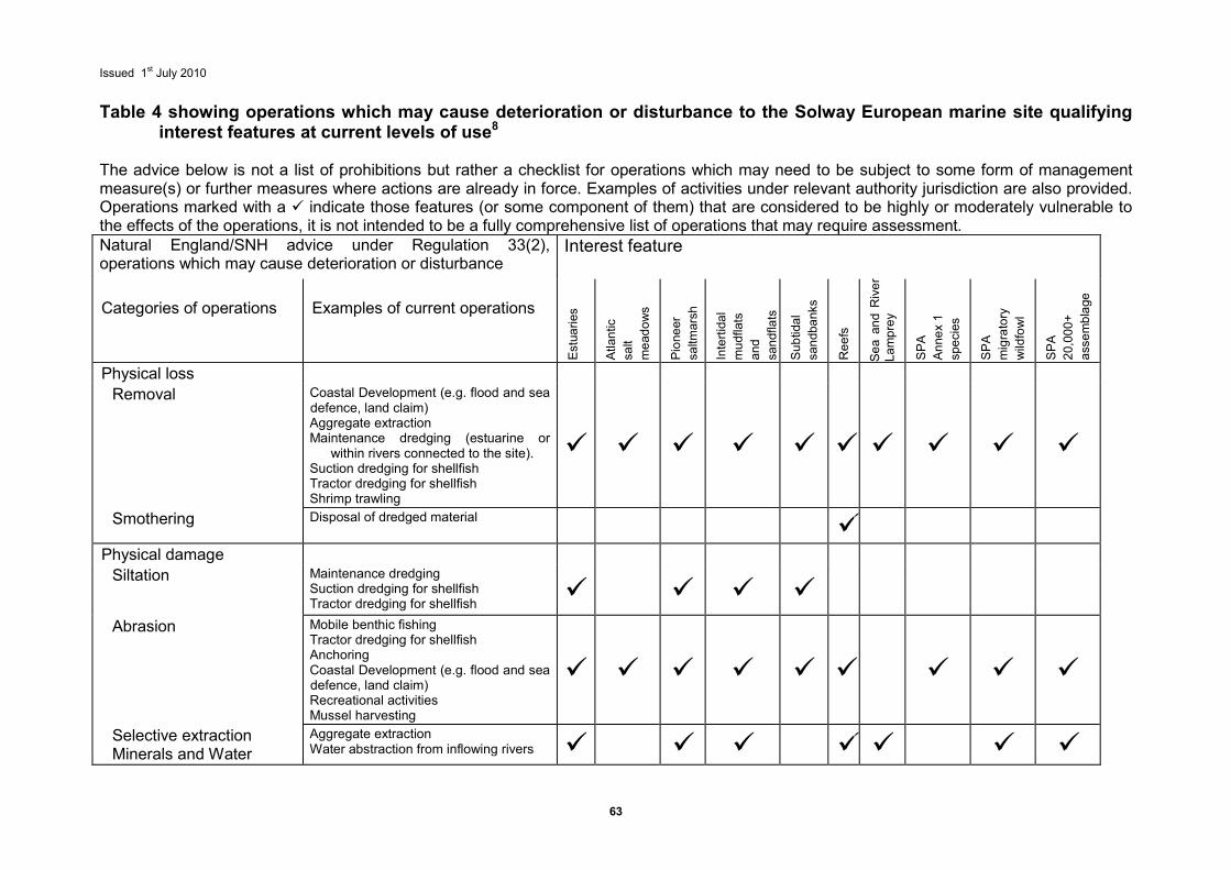
Issued 1st July 2010
63
Table 4 showing operations which may cause deterioration or disturbance to the Solway European marine site qualifying
interest features at current levels of use8 The advice below is not a list of prohibitions but rather a checklist for operations which may need to be subject to some form of management measure(s) or further measures where actions are already in force. Examples of activities under relevant authority jurisdiction are also provided. Operations marked with a � indicate those features (or some component of them) that are considered to be highly or moderately vulnerable to the effects of the operations, it is not intended to be a fully comprehensive list of operations that may require assessment. Natural England/SNH advice under Regulation 33(2), operations which may cause deterioration or disturbance
Interest feature
Categories of operations
Examples of current operations
Estuaries
Atlantic
salt
meadows
Pioneer
saltmarsh
Intertidal
mudflats
and
sandflats
Subtidal
sandbanks
Reefs
Sea and River
Lamprey
SPA
Annex 1
species
SPA
migratory
wildfowl
SPA
20,000+
assemblage
Physical loss
Removal Coastal Development (e.g. flood and sea defence, land claim) Aggregate extraction Maintenance dredging (estuarine or
within rivers connected to the site). Suction dredging for shellfish Tractor dredging for shellfish Shrimp trawling
� � � � � � � � � �
Smothering Disposal of dredged material �
Physical damage
Siltation Maintenance dredging Suction dredging for shellfish Tractor dredging for shellfish
� � � �
Abrasion Mobile benthic fishing Tractor dredging for shellfish Anchoring Coastal Development (e.g. flood and sea defence, land claim) Recreational activities Mussel harvesting
� � � � � � � � �
Selective extraction Minerals and Water
Aggregate extraction Water abstraction from inflowing rivers � � � � � � �
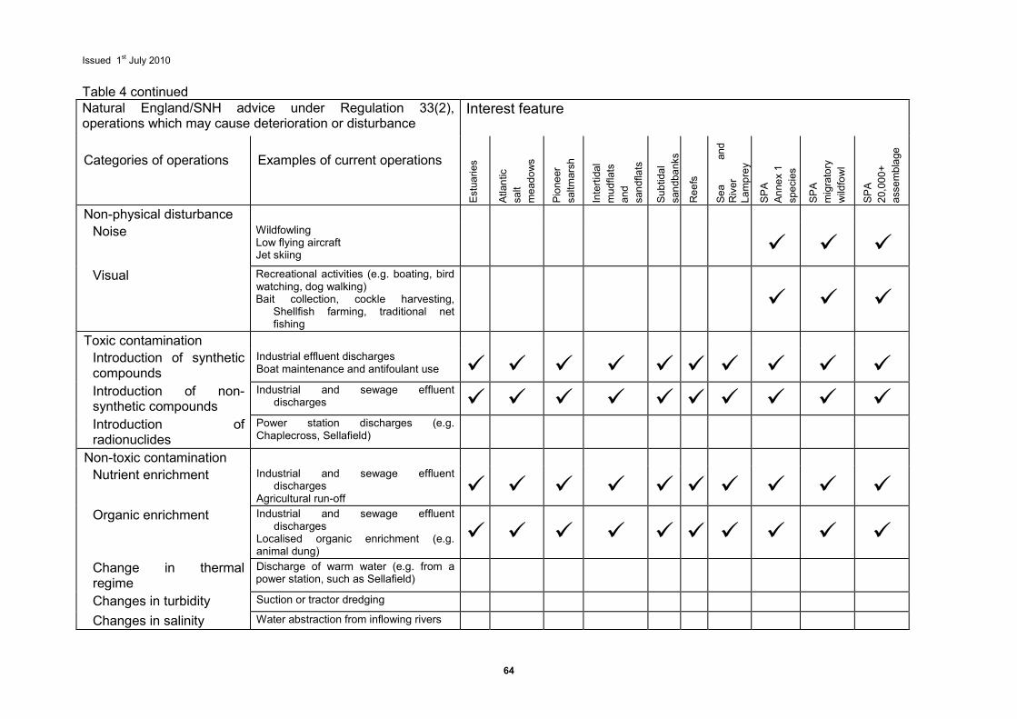
Issued 1st July 2010
64
Table 4 continued Natural England/SNH advice under Regulation 33(2), operations which may cause deterioration or disturbance
Interest feature
Categories of operations
Examples of current operations
Estuaries
Atlantic
salt
meadows
Pioneer
saltmarsh
Intertidal
mudflats
and
sandflats
Subtidal
sandbanks
Reefs
Sea
and
River
Lamprey
SPA
Annex 1
species
SPA
migratory
wildfowl
SPA
20,000+
assemblage
Non-physical disturbance
Noise Wildfowling Low flying aircraft Jet skiing
� � �
Visual Recreational activities (e.g. boating, bird watching, dog walking) Bait collection, cockle harvesting,
Shellfish farming, traditional net fishing
� � �
Toxic contamination
Introduction of synthetic compounds
Industrial effluent discharges Boat maintenance and antifoulant use � � � � � � � � � �
Introduction of non-synthetic compounds
Industrial and sewage effluent discharges � � � � � � � � � �
Introduction of radionuclides
Power station discharges (e.g. Chaplecross, Sellafield)
Non-toxic contamination
Nutrient enrichment Industrial and sewage effluent discharges
Agricultural run-off � � � � � � � � � �
Organic enrichment Industrial and sewage effluent discharges
Localised organic enrichment (e.g. animal dung)
� � � � � � � � � �
Change in thermal regime
Discharge of warm water (e.g. from a power station, such as Sellafield)
Changes in turbidity Suction or tractor dredging
Changes in salinity Water abstraction from inflowing rivers
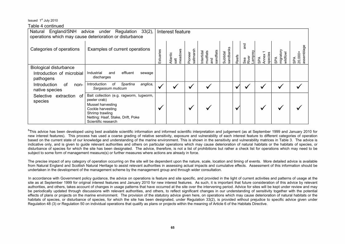
Issued 1st July 2010
65
Table 4 continued Natural England/SNH advice under Regulation 33(2), operations which may cause deterioration or disturbance
Interest feature
Categories of operations
Examples of current operations
Estuaries
Atlantic
salt
meadows
Pioneer
saltmarsh
Intertidal
mudflats
and
sandflats
Subtidal
sandbanks
Reefs
Sea
and
River
Lamprey
SPA
Annex 1
species
SPA
migratory
wildfowl
SPA
20,000+
assemblage
Biological disturbance
Introduction of microbial pathogens
Industrial and effluent sewage discharges
Introduction of non-native species
Introduction of Spartina anglica, Sargassum muticum � � � � � � � � �
Selective extraction of species
Bait collection (e.g. ragworm, lugworm, peeler crab) Mussel harvesting Cockle harvesting Shrimp trawling Netting: Haaf, Stake, Drift, Poke Scientific research
� � � � � � �
8This advice has been developed using best available scientific information and informed scientific interpretation and judgement (as at September 1999 and January 2010 for new interest features). This process has used a coarse grading of relative sensitivity, exposure and vulnerability of each interest feature to different categories of operation based on the current state of our knowledge and understanding of the marine environment. This is shown in the sensitivity and vulnerability matrices in Table 3. The advice is indicative only, and is given to guide relevant authorities and others on particular operations which may cause deterioration of natural habitats or the habitats of species, or disturbance of species for which the site has been designated. The advice, therefore, is not a list of prohibitions but rather a check list for operations which may need to be subject to some form of management measure(s) or further measures where actions are already in force. The precise impact of any category of operation occurring on the site will be dependent upon the nature, scale, location and timing of events. More detailed advice is available from Natural England and Scottish Natural Heritage to assist relevant authorities in assessing actual impacts and cumulative effects. Assessment of this information should be undertaken in the development of the management scheme by the management group and through wider consultation. In accordance with Government policy guidance, the advice on operations is feature and site specific, and provided in the light of current activities and patterns of usage at the site as at September 1999 for original interest features and January 2010 for new interest features. As such, it is important that future consideration of this advice by relevant authorities, and others, takes account of changes in usage patterns that have occurred at the site over the intervening period. Advice for sites will be kept under review and may be periodically updated through discussions with relevant authorities, and others, to reflect significant changes in our understanding of sensitivity together with the potential effects of plans or projects on the marine environment. The provision of the statutory advice given here, on operations which may cause deterioration of natural habitats or the habitats of species, or disturbance of species, for which the site has been designated, under Regulation 33(2), is provided without prejudice to specific advice given under Regulation 48 (3) or Regulation 50 on individual operations that qualify as plans or projects within the meaning of Article 6 of the Habitats Directive.
Issued 1st July 2010
66
9.2 Interest feature and sub-feature specific advice on operations This section includes information in support of the advice required under Regulation 33(2)(b). This section provides information to help relate general advice to each of the specific interest features of the Special Area of Conservation that fall within the European marine site. These interest features are:
• Estuaries • Salicornia and other annuals colonising mud and sand • Atlantic salt meadows • Mudflats and sandflats not covered by seawater at low tide • Sandbanks which are slightly covered by sea water all the time • Reefs • River and sea lamprey • SPA interests
This advice relates to the vulnerability of the interest features and sub-features of the Solway European marine site to current levels of human usage as summarised in Table 4 and detailed in Table 5. An explanation of the sensitivity of the interest features or sub-features follows with examples of their exposure and therefore their vulnerability to damage or disturbance from the listed categories of operations. This enables links between the categories of operation and the ecological requirements of the European marine site’s interest features, as set out in Section 3, to be made. The categories of operations may cause damage or disturbance to the interest features and sub-features of the European marine site, either alone or in combination. 9.2.1 Estuaries i) Physical loss • The Solway Firth European marine site is a complex system, comprising one of the
largest shallow estuaries in the UK and supports an important diversity of intertidal and subtidal habitats, and associated internationally important marine species and communities. The physical loss of this estuarine habitat, or parts of it, would be detrimental to the favourable condition of the site.
• Physical loss can occur through the removal or smothering of the interest features and/or
sub-features and can arise from many sources, such as one-off developments, coastal protection works or land claim. All the sub-features of the estuary are sensitive to removal and most are sensitive to smothering. For example, Salicornia and other annuals colonising mud and sand and Atlantic salt meadows are particularly vulnerable to coastal development. Such activity may also impact upon the intertidal mudflats and sandflats, subtidal sandbanks, reefs and the intertidal scar ground sub-feature.
• The Solway estuarine complex is reliant on sustaining its morphological equilibrium
through maintaining its sediment budget. Removal or smothering of sediment will cause loss of marine communities, which will consequently effect the composition and distribution of estuarine habitats.
ii) Physical damage • Most estuarine communities are relatively tolerant of the naturally turbid or silty
conditions that naturally occur. This is also true of the Solway although, unusually, there is a lower silt composition and a higher fine sand content. Changes in the grain size of intertidal and subtidal sediments, caused by an increased input of fine material, can alter
Issued 1st July 2010
67
their community composition. Modification of the natural sedimentation patterns can impact upon the condition of the estuary. Although the risk of siltation from ongoing activities are low, the intertidal mudflats and sandflats, subtidal sandbanks, pioneer saltmarsh and scar ground communities are considered to be sensitive to siltation. Should activities which cause siltation increase in scale a higher vulnerability rating may be required.
• All estuarine habitats and communities can be physically damaged through abrasion.
Rocky scar ground communities are particularly sensitive and vulnerable to abrasion caused by the turning over of rocks during the collection of ragworms for fishing bait. Ragworm collection does occur on the Solway, but has not so far occurred on a regular or large scale basis, sensitivity is therefore high and vulnerability is only considered moderate because of its infrequent occurrence. Other abrasive activities include raking for mussels.
• The selective extraction of part of an interest feature such as the removal of worms for
bait from intertidal mudflats and sandflats and particularly intertidal scar grounds may alter its ecology, affecting not only the biological composition of the sediments but also having implications on the food supply of birds. Bait digging for both lugworms and ragworms occurs on the site. Intertidal mudflats and sandflats and intertidal scar grounds are therefore considered moderately vulnerable to the effects of this activity.
iii) Toxic contamination • All the sub-features of the estuary are considered both highly sensitive and potentially
vulnerable to the effects of toxic contamination. This is because industrial and sewage effluent discharges, for example, introduce synthetic and non-synthetic compounds into the Solway, to which many of the communities or species of the estuarine habitats are sensitive.
• Synthetic and non-synthetic compounds and radionuclides can bioaccumulate and
bioconcentrate in biological systems, building up in the food chain and becoming available to higher predators in potentially lethal dosages. Heavy metals in particular, which are introduced into the estuary through sewage and industrial effluent discharges and from antifouling paints on vessels, may have a range of effects on many different animal and plant species. Their toxic effects on infaunal invertebrates, rocky scar communities and accumulation in saltmarsh grasses are of greatest concern.
• All estuarine sub-features within the Solway, particularly Atlantic salt meadows and
saltmarsh, are considered sensitive to oil. The toxic and smothering effects of oil are well documented and particular attention should be given to both diffuse and point sources of oil within the estuary.
iv) Non-toxic contamination • A significant increase in nutrients (e.g. phosphates and nitrates) as a result of effluent
discharges or agricultural run-off may alter the diversity of communities living within the estuary. Some species, such as certain ephemeral green algae, thrive in response to increased nutrients, often at the expense of other species. As a consequence, ecological communities may be altered.
• Similarly, an excessive increase in the organic loading of, for example intertidal
sediments, can affect the infaunal community structure. Discharge of effluent, particularly of domestic sewage, could be a notable source of organic enrichment within the estuary.
Issued 1st July 2010
68
• Activities which result in an input of non-toxic contaminants (from diffuse or point sources) that significantly alter the physical and chemical regime (e.g. salinity profile or temperature) of the water or sediment within the estuary, have the potential to cause damage to sensitive communities or species within the site. This would therefore be detrimental to favourable condition of the estuary interest feature.
v) Biological disturbance • Biological disturbance can occur through the selective extraction of species from the
estuary, or through the introduction or translocation of non-native species to the estuary. Both these processes can result in an altered community structure. Saltmarsh communities and intertidal mud and sand are particularly sensitive to the introduction of cord grass Spartina anglica which has been known to quickly change the structure of the existing saltmarsh and intertidal sand and mud. Currently the extent of cord grass throughout the site is low.
• Similarly, the removal of certain marine animals such as peeler crabs, lugworms and
ragworms, through bait collection, may affect the ecological balance of the marine communities. Scar grounds are especially sensitive to the removal of important elements of the community such as ragworms. This practice may cause biological disturbance through removing a key predator of other marine invertebrates, and key food source for other estuarine predators such as fish and birds. Importantly, scar grounds have very long recovery periods from biological disturbance.
9.2.2 Salicornia and other annuals colonising mud and sand i) Physical loss • This interest feature is sensitive to removal and/or smothering and activities, such as
coastal development, may result in the loss of this interest feature. It is therefore considered vulnerable to their effects.
ii) Physical damage • This interest feature is composed of annual species and may suffer physical damage
through the abrasive effects of activities including ancillary fishing techniques such as bait collection. These uproot Salicornia spp. plants and destabilise the mudflats on which they grow. A change in siltation patterns can also effect the formation (or otherwise) of pioneer saltmarsh.
iii) Toxic contamination • Salicornia and other annuals colonising mud and sand are sensitive to toxic
contaminants which, for example, have direct and/or indirect effects on the plant and animal communities which live within them. Salicornia spp. can bioaccumulate contaminants which can have effects on other species that use this plant.
iv) Biological disturbance • The invasive cord grass Spartina anglica can significantly impact upon pioneer marshes
through direct competition. Currently the extent and distribution of cord grass is low, therefore, vulnerability to this effect is considered to be low. However, should there be a significant spread of this species then it is likely that the vulnerability rating would rise.
Issued 1st July 2010
69
9.2.3 Atlantic salt meadows (Glauco-Puccinellietalia maritimae) i) Physical loss • All the sub-features of Atlantic salt meadows are considered both sensitive and
vulnerable to physical loss by removal. The saltmarsh sub-features form a closely interrelated transition and removal of any one or more of the sub-features will affect the overall community structure of the interest feature. For example, land claim, may result in removal of saltmarsh. Man-made physical barriers, such as seawalls prevent the inland migration of marshes, in relation to sea level rise.
ii) Physical damage • Atlantic salt meadows, most of which are grazed throughout the year, are vulnerable to
undergrazing, overgrazing and poaching which all can affect saltmarsh diversity and structure.
• Recreational activities on saltmarsh, such as the use of four wheel drive vehicles, can
physically damage its structure, for example by compaction. It can often take long periods of time to recover from the impacts of such activities, with furrows remaining visible for years after the event.
iii) Toxic contamination • Atlantic salt meadows are sensitive to toxic contaminants which can have direct and/or
indirect effects on the plant and animal communities which live within them. Saltmarsh plants can bioaccumulate contaminants which have effects on other species that use them.
iv) Biological disturbance • The invasive cord grass Spartina anglica can significantly impact upon lower- and mid-
saltmarsh communities through direct competition. Due to current low levels of exposure, vulnerability to this effect is considered to be low.
9.2.4 Mudflats and sandflats not covered by seawater at low tide i) Physical loss • Mudflats and sandflats of the intertidal zone are particularly vulnerable to coastal
developments such as flood and coastal defence works and land claim. Aggregate extraction occurring on the site can result in the removal of this habitat. Loss of these intertidal habitats, which are themselves natural sea defences and which contribute significantly to the reduction of tidal and wave energy within the estuary, may result in a deterioration of the condition of other interest features on the site. Currently aggregate extraction at the site is occurring at a low level.
ii) Physical damage • Activities that result in abrasion such as dredging, hand gathering of cockles using rakes
and digging for bait, can cause the destabilisation of the sediment which may increase erosion rates. This may alter the structure and function (both physically and biologically) of any sub-features of the flats and ultimately could lead to loss of the interest feature.
Issued 1st July 2010
70
iii) Toxic contamination • All the sub-features of mudflats and sandflats are considered vulnerable to the
introduction of synthetic and non-synthetic compounds. Such compounds can have both lethal and sub-lethal toxic effects on marine species, and may alter their species diversity and composition within the sediment. Larval stages of invertebrates are in many cases more sensitive than the adults. Sub-lethal effects are more difficult to observe and assess but often can be as detrimental as lethal effects.
• Intertidal sediments can act as sinks for nutrients, metals and radionuclides. If disturbed,
these can be released into the water column and become available for uptake by animals and plants. This may be an area of concern with activities such as suction dredging.
iv) Non-toxic contamination • Within the Solway estuary complex, the habitats considered to be at greatest threat from
non-toxic contamination are the intertidal mudflats and sandflats and are consequently given a moderate sensitivity. The effects of agricultural run-off and domestic sewage can locally lower oxygen levels, making the flats anoxic. Many infaunal communities require a good supply of oxygen whilst some estuarine species are more tolerant of eutrophication and organic enrichment and thrive in such conditions. The consequence of this is an alteration of community composition.
• Localised eutrophication can also result in increased volumes of ephemeral algae and
areas covered by algal mats. Algal mats, amongst others, are responsible for suppressing the aeration of burrowing worm and bivalve tunnels and as a consequence, species requiring better ventilation may be disadvantaged and the community structure may change.
v) Biological disturbance • The removal of particular species or groups of species from the intertidal sediments
occurs on the site through activities such as bait digging, albeit at a relatively low level. Targeting different species can have a variety of effects on the habitats. Characteristic species of the interest feature such as lugworms and peeler crabs (collected at specific times of the year) play an important and complex role in the functioning of the ecology of the intertidal flats. Each of these species also occurs in different parts of the habitat, which may be disturbed through the collection process.
• The introduction of the invasive cord grass Spartina anglica can significantly impact upon
mudflats. It is an aggressive pioneer marsh species, and changes the sediment structure as its roots stabilise the mudflats, which subsequently alters the associated infaunal community. It is a recognised problem in many parts of the UK, although it is not a major issue for the Solway.
9.2.5 Sandbanks which are slightly covered by seawater all the time i) Physical loss • Within the estuary sandbanks of the subtidal zone may be lost as a result of aggregate
extraction, coastal defences and certain fishing methods. As previously mentioned, within an estuary system the maintenance of the sediment budget and balance is vital to ensuring site integrity. Subtidal sandbanks act as important sources of sediment to the
Issued 1st July 2010
71
other habitats, removal or loss of these may have knock-on affects elsewhere in the site. Currently the scale of such activities is low. Therefore a vulnerability rating of moderate
has been given. Should the scale or intensity of these activities increase the vulnerability rating may rise accordingly. ii) Physical damage • Subtidal sandbanks may be damaged as a direct result of aggregate extraction and
possibly as an indirect result of construction of coastal defences or certain fishing methods. Subtidal sandbanks are important sediment sources and are an integral part of the estuary sediment budget and their loss may, therefore, have significant knock-on effects elsewhere. The current scale of relevant activities is low and the vulnerability rating has been determined as moderate. Should the scale or intensity of these activities increase, the vulnerability rating may rise accordingly.
iii) Toxic contamination • Subtidal sediments are sensitive to toxic contaminants for the reasons given for intertidal
sediments previously (see Section 9.2.4). iv) Non-toxic contamination • As with intertidal mudflats and sandflats, organic matter can accumulate in subtidal
sediments, reducing the oxygen content and altering the community structure and species diversity.
9.2.6 Reefs i) Physical loss • In the Solway, the biogenic reefs are highly or moderately vulnerable to removal or
smothering. For example fishing activities involving dredging could lead to the physical loss of biogenic reefs and associated species in the areas dredged and may lead to localised smothering of benthic communities at, or close to, the depositing grounds. However, dredging of reef areas is currently limited and may be acceptable over restricted areas of ephemeral biogenic reef. Although there is a high sensitivity to such activities, the current exposure is low and therefore the reefs of the Solway Firth are not currently moderately vulnerable to such impacts.
• Shellfishery activities (e.g. oyster cultivation and cockle/mussel harvesting) in the vicinity
of or on biogenic reefs may lead to the actual destruction of the habitat either through shellfish extraction or vehicular access to the fishing beds. Current fishing effort is low however and is regulated on areas of public fisheries by Cumbria Sea Fisheries Committee. Although there is a high sensitivity to such activities, the current exposure is well managed and therefore the reefs of the Solway Firth are not currently moderately vulnerable to such impacts.
ii) Physical damage • Damage occurring through activities, such as those associated with shellfishery activities
could reduce the viability of the habitat block as a whole as described above. • Placement of industrial infrastructure related to offshore developments, such as wind
farms, on reefs could lead to adverse impacts. However, this impact has not been
Issued 1st July 2010
72
known to occur to date within the Solway Firth so the reefs are not currently vulnerable to such impacts.
• Long-term or frequent mooring of boats to anchor points situated on or near reef habitat
can result in localised loss of habitat in circular areas around the anchor point due to rope or chain scouring. However, this impact has not been known to occur to date within the Solway Firth and the reefs are therefore not thought to be vulnerable to such impacts.
iii) Toxic contamination • Biogenic reefs are sensitive to toxic contaminants for the reasons given for intertidal
sediments previously (see Section 9.2.4). • Reef communities are also sensitive to synthetic/non-synthetic compounds and
radionuclides for the reasons given within the estuaries section (see Section 9.2.1)
iv) Non-toxic contamination • Biogenic reefs may be sensitive to increased nutrient levels either from agricultural
run-off or domestic sewage by reduction in oxygen levels. This may impact on species such as horse mussel or tubeworm and associated plant and animal communities. Some require a good supply of oxygen whilst other species are more tolerant of eutrophication and organic enrichment and thrive in such conditions. The consequence of this could be an alteration of community composition.
v) Biological disturbance • In addition to physical loss, the impacts of fisheries such as cockle harvesting, hand
gathering of mussels and shrimp trawling may lead to selective extraction of the important species relating to this feature (e.g. Mytillis edulis). Current fishing effort is low however and is regulated on areas of public fisheries by Cumbria Sea Fisheries Committee. Although there is a high sensitivity to such activities, the current exposure is well managed and therefore the reefs of the Solway Firth are currently moderately vulnerable to such impacts.
9.2.7 River and sea lamprey i) Physical loss
• Little is known about the ecology of lampreys in the marine environment but as their prey species are fish, and they can grow to 100cms in length, it is likely that they inhabit the deeper water of the estuary. Adult river and sea lamprey live in estuaries and feed on a wide variety of marine and anadromous fishes, including plaice, dab, flounder, salmon and sea trout. The presence of adequate fish stocks within the estuary is essential for maintaining lamprey population levels. Reduction in the amount or quality of habitat within the estuary could reduce the diversity and viability of fish populations upon which both lamprey species feed. The extent and quality of habitats within the estuary must be maintained to ensure that fish stocks remain viable. It is not known to what extent this is an impact on current population levels of River and Sea Lamprey in the Solway Firth. However, for the reasons given above, maintaining diverse and viable populations of fish is thought to be crucial for their own viability.
• It is essential to the survival of both species that engineering works and fisheries
improvement works in rivers that flow into the estuary do not create barriers to migration. Similarly it is vital that silty slow–flowing areas of these rivers, particularly backwater areas, used by developing ammocoetes are not dredged or in-filled. The creation of
Issued 1st July 2010
73
dams, weirs, bridges, and river bank protection and developments need to be carefully considered with respect to the habitat requirements of lampreys.
ii) Physical damage • Physical damage to habitats within the estuary could reduce the ecological resources
that support fish, the food source for lampreys. Maintaining the physical integrity of the full range of habitat features is important for sustaining fish stocks.
• Water levels in rivers used by lamprey species that flow into the estuary need to be
managed to prevent extreme low flows that could impede the upstream migration of adults to spawn between March and June and the subsequent downstream migration of hatched ammocoetes. Lampreys appear to use periods of high water flow for downstream migration.
• Obstructions within the channels of the estuary leading into the mouth of rivers or within
river channels could prevent or impede adult lampreys swimming upstream to spawning grounds or restrict the passage of juveniles into the estuary. Proposals to construct barrages, weirs and dams would need to consider lamprey migration.
iii) Toxic contamination • Both Sea and River Lamprey species require reasonably good water quality. Polluting
discharges to rivers used by the species for spawning could create a barrier to, or reduce upstream migration, and may impede or entirely prevent spawning taking place. Toxic substances released to river or estuarine waters could affect lampreys directly, by affecting the fish that provide their food or indirectly by impacting on lower organisms within the food chain. Contamination of soft sediments in lower river reaches could prevent their use as habitat for burrowing juvenile lampreys. In the absence of specific tolerance data for sea lampreys it must be assumed that conditions in all parts of any river where they occur, or pass through on migration, are at least UK Water Quality Class B in England, or A2 in Scotland.
iv) Non-toxic contamination • Beamish (1974) in Maitland PS (2003) reported that the oxygen consumption of adult sea
lamprey at various temperatures is comparable to salmonids of similar weight. Lampreys therefore require water with a low level of organic pollution, since pollutants from organic sources provide an excess of nutrients, stimulating the growth of micro–organisms, resulting in oxygen consumption and reducing the amount available to larger organisms such as fish and lamprey.
v) Biological disturbance • Lampreys are sometimes sought as bait for fishing. Indiscriminate trapping of adults
and/or ammocoetes within the estuary or upstream could affect the viability of lamprey populations by reducing the number available to spawn. Digging for larvae in soft substrate in rivers would affect population abundance directly but could also significantly damage the habitat in which they live. However, there is little evidence that such practices are occurring at present either within the estuary or upstream and therefore the vulnerability of these species is currently low.

Issued 1st July 2010
74
9.2.8 Special Protection Area interests i) Physical loss • Birds rely on intertidal sediments, rocky scars and saltmarshes for feeding and roosting.
Loss of these habitats through removal or smothering will be detrimental to their condition. Examples of activities which occur on the site that may lead to loss of habitat include dredged spoil disposal, land claim and aggregate extraction. Currently exposure levels of all these activities are low.
ii) Physical damage • Habitats within the Solway which support SPA interests such as the saltmarsh, intertidal
sediments and rocky scars, are particularly sensitive to those types of physical damage which reduce food availability to the birds, or change the suitability of habitats for roosting or feeding.
• Waterfowl also have the potential to become entangled in litter or debris. At current
exposure levels however, vulnerability to this threat appears to be low. iii) Non-physical disturbance • Waterfowl are sensitive to both visual and noise disturbance, which can have the effect
of displacing them from their roosting, feeding or breeding grounds. Birds affected by these types of disturbance may move to an alternative and perhaps less favourable site, or increase their energy expenditure through flight. These sort of responses, affect the birds’ energy budgets and thus their survival and possible reproductive success. Overwintering waterfowl are birds which migrate often large distances and are particularly sensitive to disturbance.
iv) Toxic contamination • There is documentary evidence of the effects of bioaccumulation of toxic compounds in
birds, from heavy metals. Effects of such toxic compounds are variable, but include reductions in breeding success and in extreme cases mortality of individuals e.g. waterfowl which accumulate lead shot in their gizzards. There is little history of heavy industry or mining within the site, which may have been sources of many of these toxic compounds, but potential issues may arise from their impact from diffuse and off-site sources. Given the potentially high sensitivity of birds to the effects of toxic substances there may be need for further information upon which to base any future monitoring.
v) Non-toxic contamination • Nutrient and/or organic enrichment can affect habitats important to birds, such as
intertidal sediments and rocky scars, for the reasons previously mentioned. This can particularly affect birds by reducing the availability of their food source by, for example, increasing growth of algal mats on the intertidal mud flats. This can reduce the numbers of invertebrates on which they feed as well as the diversity of their food supply. Similarly, contamination by substances such as oil can reduce the quality of a habitat for feeding or roosting.
vi) Biological disturbance • Selective extraction of certain species from a habitat necessary to support birds, can
affect its community structure and function. The ability of that habitat to continue to

Issued 1st July 2010
75
support those birds can be therefore reduced. An example of this would be the selective extraction of ragworms for fishing bait. The ecological implications of removing this species from the food web may be great.
Similarly, the introduction of the invasive cord grass Spartina anglica can significantly impact upon the ecology of mudflats. The ability of the mudflats to support bird species may therefore be compromised.
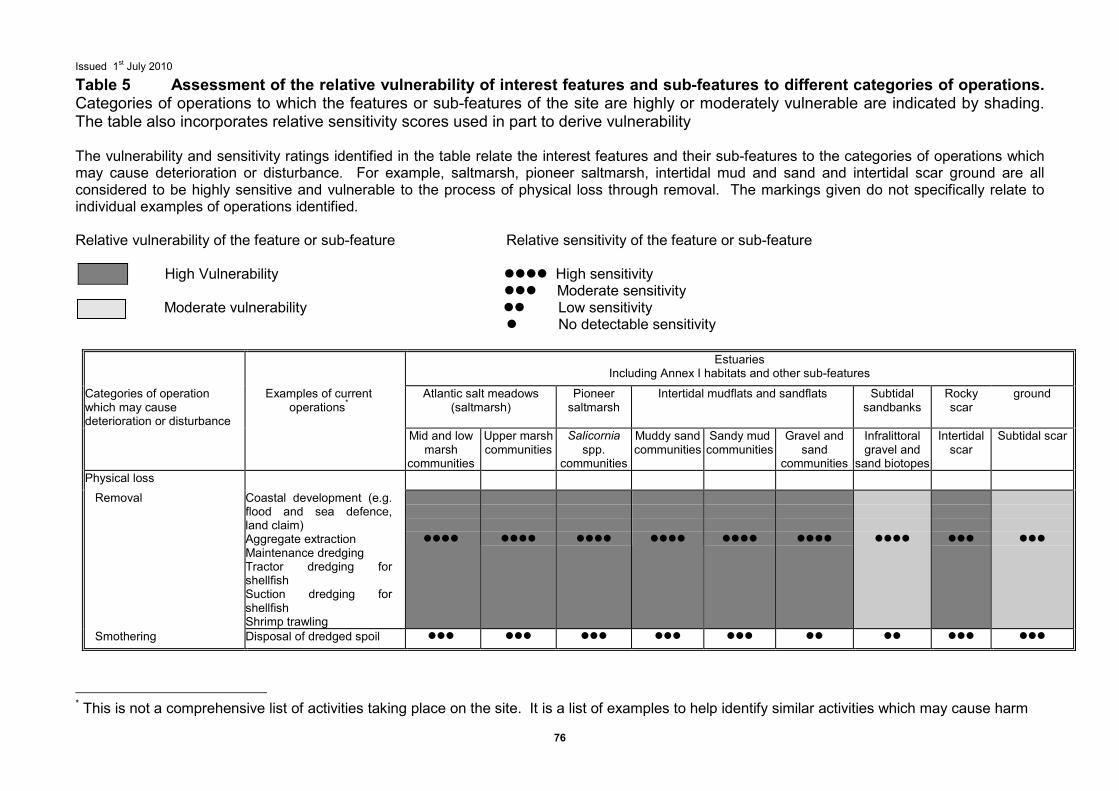
Issued 1st July 2010
76
Table 5 Assessment of the relative vulnerability of interest features and sub-features to different categories of operations. Categories of operations to which the features or sub-features of the site are highly or moderately vulnerable are indicated by shading. The table also incorporates relative sensitivity scores used in part to derive vulnerability The vulnerability and sensitivity ratings identified in the table relate the interest features and their sub-features to the categories of operations which may cause deterioration or disturbance. For example, saltmarsh, pioneer saltmarsh, intertidal mud and sand and intertidal scar ground are all considered to be highly sensitive and vulnerable to the process of physical loss through removal. The markings given do not specifically relate to individual examples of operations identified. Relative vulnerability of the feature or sub-feature Relative sensitivity of the feature or sub-feature
High Vulnerability ���� High sensitivity ��� Moderate sensitivity
Moderate vulnerability �� Low sensitivity � No detectable sensitivity
Estuaries
Including Annex I habitats and other sub-features
Categories of operation which may cause deterioration or disturbance
Examples of current operations*
Atlantic salt meadows (saltmarsh)
Pioneer saltmarsh
Intertidal mudflats and sandflats Subtidal sandbanks
Rocky scar
ground
Mid and low marsh
communities
Upper marsh communities
Salicornia spp.
communities
Muddy sand communities
Sandy mud communities
Gravel and sand
communities
Infralittoral gravel and
sand biotopes
Intertidal scar
Subtidal scar
Physical loss
Removal Coastal development (e.g. flood and sea defence, land claim) Aggregate extraction Maintenance dredging Tractor dredging for shellfish Suction dredging for shellfish Shrimp trawling
����
����
����
����
����
����
����
���
���
Smothering Disposal of dredged spoil ��� ��� ��� ��� ��� �� �� ��� ���
* This is not a comprehensive list of activities taking place on the site. It is a list of examples to help identify similar activities which may cause harm
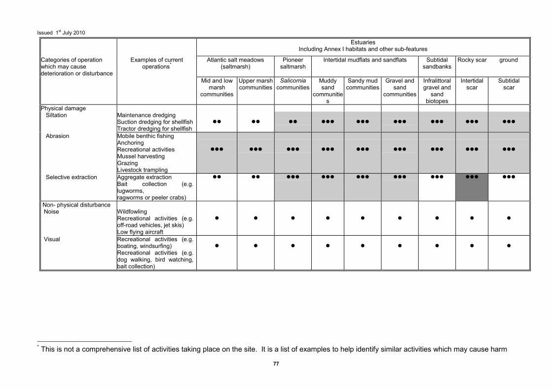
Issued 1st July 2010
77
Estuaries Including Annex I habitats and other sub-features
Categories of operation which may cause deterioration or disturbance
Examples of current operations*
Atlantic salt meadows (saltmarsh)
Pioneer saltmarsh
Intertidal mudflats and sandflats Subtidal sandbanks
Rocky scar ground
Mid and low marsh
communities
Upper marsh communities
Salicornia communities
Muddy sand
communities
Sandy mud communities
Gravel and sand
communities
Infralittoral gravel and sand
biotopes
Intertidal scar
Subtidal scar
Physical damage Siltation Maintenance dredging
Suction dredging for shellfish Tractor dredging for shellfish
��
��
��
���
���
���
���
���
���
Abrasion Mobile benthic fishing Anchoring Recreational activities Mussel harvesting Grazing Livestock trampling
���
���
���
���
���
���
���
���
���
Selective extraction Aggregate extraction Bait collection (e.g. lugworms, ragworms or peeler crabs)
�� �� ��� ��� ��� ��� ��� ��� ���
Non- physical disturbance Noise
Wildfowling Recreational activities (e.g. off-road vehicles, jet skis) Low flying aircraft
�
�
�
�
�
�
�
�
�
Visual Recreational activities (e.g. boating, windsurfing) Recreational activities (e.g. dog walking, bird watching, bait collection)
�
�
�
�
�
�
�
�
�
* This is not a comprehensive list of activities taking place on the site. It is a list of examples to help identify similar activities which may cause harm
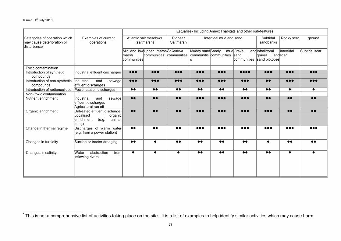
Issued 1st July 2010
78
Estuaries- Including Annex I habitats and other sub-features
Categories of operation which may cause deterioration or disturbance
Examples of current operations*
Atlantic salt meadows (saltmarsh)
Pioneer Saltmarsh
Intertidal mud and sand Subtidal sandbanks
Rocky scar ground
Mid and low marsh communities
Upper marsh communities
Salicornia communities
Muddy sand communities
Sandy mud communities
Gravel and sand communities
Infralittoral gravel and sand biotopes
Intertidal scar
Subtidal scar
Toxic contamination Introduction of synthetic
compounds Industrial effluent discharges ��� ��� ��� ��� ��� ���� ��� ��� ���
Introduction of non-synthetic compounds
Industrial and sewage effluent discharges
��� ��� ��� ��� ��� ��� �� ��� ���
Introduction of radionuclides Power station discharges �� �� �� �� �� �� �� � � Non- toxic contamination Nutrient enrichment Industrial and sewage
effluent discharges Agricultural run off
�� �� �� ��� ��� ��� �� �� ��
Organic enrichment Untreated effluent discharge Localised organic enrichment (e.g. animal dung)
�� �� �� ��� ��� ��� ��� �� ��
Change in thermal regime Discharges of warm water (e.g. from a power station)
�� �� �� ��� ��� ��� ��� ��� ���
Changes in turbidity Suction or tractor dredging �� � �� �� �� �� � �� ��
Changes in salinity Water abstraction from inflowing rivers
� � � �� �� �� �� � �
* This is not a comprehensive list of activities taking place on the site. It is a list of examples to help identify similar activities which may cause harm
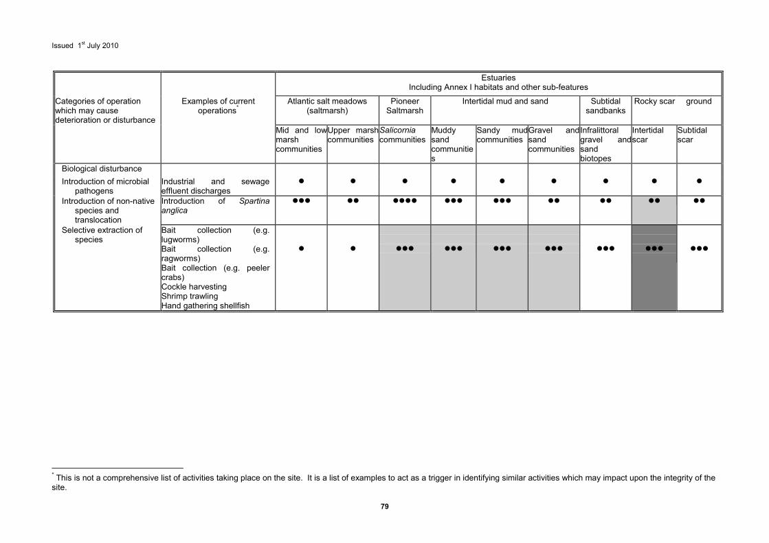
Issued 1st July 2010
79
Estuaries
Including Annex I habitats and other sub-features
Categories of operation which may cause deterioration or disturbance
Examples of current operations*
Atlantic salt meadows (saltmarsh)
Pioneer Saltmarsh
Intertidal mud and sand Subtidal sandbanks
Rocky scar ground
Mid and low marsh communities
Upper marsh communities
Salicornia communities
Muddy sand communities
Sandy mud communities
Gravel and sand communities
Infralittoral gravel and sand biotopes
Intertidal scar
Subtidal scar
Biological disturbance
Introduction of microbial pathogens
Industrial and sewage effluent discharges
� � � � � � � � �
Introduction of non-native species and translocation
Introduction of Spartina anglica
��� �� ���� ��� ��� �� �� �� ��
Selective extraction of species
Bait collection (e.g. lugworms) Bait collection (e.g. ragworms) Bait collection (e.g. peeler crabs) Cockle harvesting Shrimp trawling Hand gathering shellfish
�
�
���
���
���
���
���
���
���
* This is not a comprehensive list of activities taking place on the site. It is a list of examples to act as a trigger in identifying similar activities which may impact upon the integrity of the site.
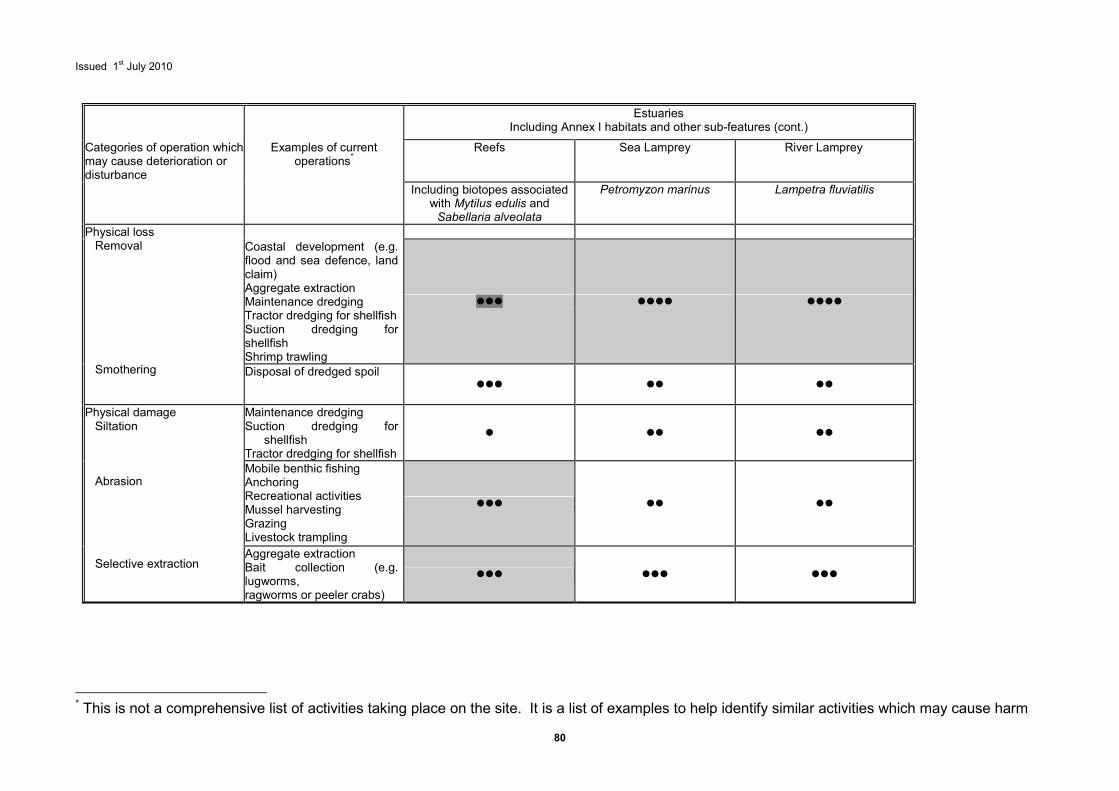
Issued 1st July 2010
80
Estuaries
Including Annex I habitats and other sub-features (cont.)
Categories of operation which may cause deterioration or disturbance
Examples of current operations*
Reefs Sea Lamprey River Lamprey
Including biotopes associated with Mytilus edulis and Sabellaria alveolata
Petromyzon marinus Lampetra fluviatilis
Coastal development (e.g. flood and sea defence, land claim) Aggregate extraction Maintenance dredging Tractor dredging for shellfish Suction dredging for shellfish Shrimp trawling
��� ���� ����
Physical loss Removal Smothering
Disposal of dredged spoil ��� �� ��
Maintenance dredging Suction dredging for
shellfish Tractor dredging for shellfish
� �� ��
Mobile benthic fishing Anchoring Recreational activities Mussel harvesting Grazing Livestock trampling
��� �� ��
Physical damage Siltation Abrasion Selective extraction
Aggregate extraction Bait collection (e.g. lugworms, ragworms or peeler crabs)
��� ��� ���
* This is not a comprehensive list of activities taking place on the site. It is a list of examples to help identify similar activities which may cause harm
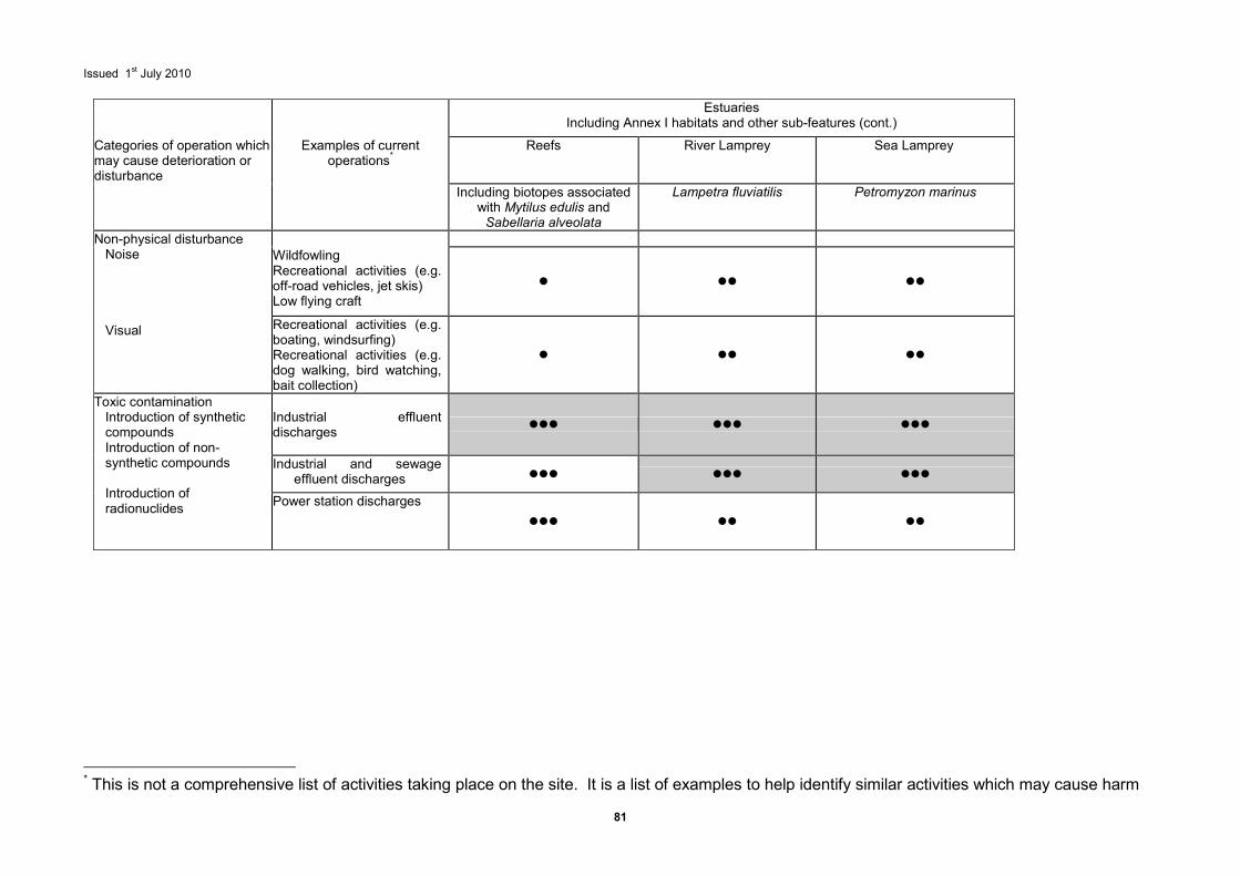
Issued 1st July 2010
81
Estuaries
Including Annex I habitats and other sub-features (cont.)
Categories of operation which may cause deterioration or disturbance
Examples of current operations*
Reefs River Lamprey Sea Lamprey
Including biotopes associated with Mytilus edulis and Sabellaria alveolata
Lampetra fluviatilis Petromyzon marinus
Wildfowling Recreational activities (e.g. off-road vehicles, jet skis) Low flying craft
� �� ��
Non-physical disturbance Noise Visual Recreational activities (e.g.
boating, windsurfing) Recreational activities (e.g. dog walking, bird watching, bait collection)
� �� ��
Industrial effluent discharges
��� ��� ���
Industrial and sewage effluent discharges ��� ��� ���
Toxic contamination Introduction of synthetic compounds Introduction of non-synthetic compounds Introduction of radionuclides Power station discharges
��� �� ��
* This is not a comprehensive list of activities taking place on the site. It is a list of examples to help identify similar activities which may cause harm
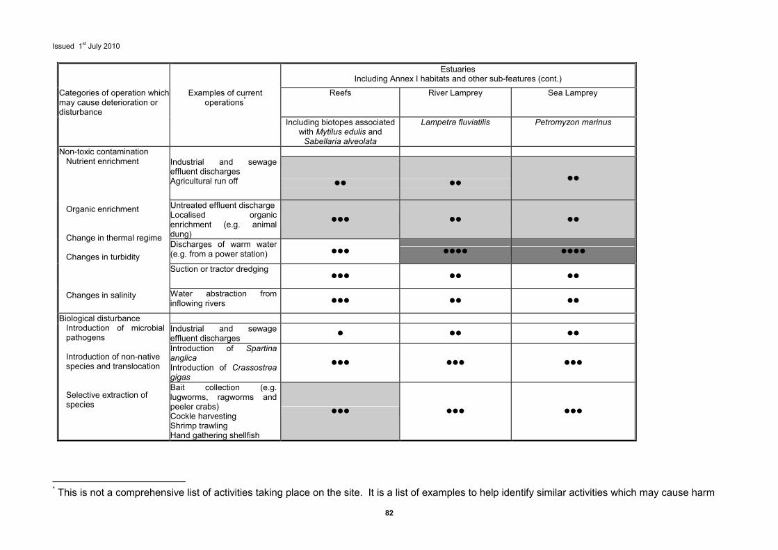
Issued 1st July 2010
82
Estuaries Including Annex I habitats and other sub-features (cont.)
Categories of operation which may cause deterioration or disturbance
Examples of current operations*
Reefs River Lamprey Sea Lamprey
Including biotopes associated with Mytilus edulis and Sabellaria alveolata
Lampetra fluviatilis Petromyzon marinus
Industrial and sewage effluent discharges Agricultural run off
��
��
��
Untreated effluent discharge Localised organic enrichment (e.g. animal dung)
��� �� ��
Discharges of warm water (e.g. from a power station) ��� ���� ����
Suction or tractor dredging ��� �� ��
Non-toxic contamination Nutrient enrichment Organic enrichment Change in thermal regime Changes in turbidity Changes in salinity Water abstraction from
inflowing rivers ��� �� ��
Industrial and sewage effluent discharges
� �� ��
Introduction of Spartina anglica Introduction of Crassostrea gigas
��� ��� ���
Biological disturbance Introduction of microbial pathogens Introduction of non-native species and translocation Selective extraction of species
Bait collection (e.g. lugworms, ragworms and peeler crabs) Cockle harvesting Shrimp trawling Hand gathering shellfish
��� ��� ���
* This is not a comprehensive list of activities taking place on the site. It is a list of examples to help identify similar activities which may cause harm
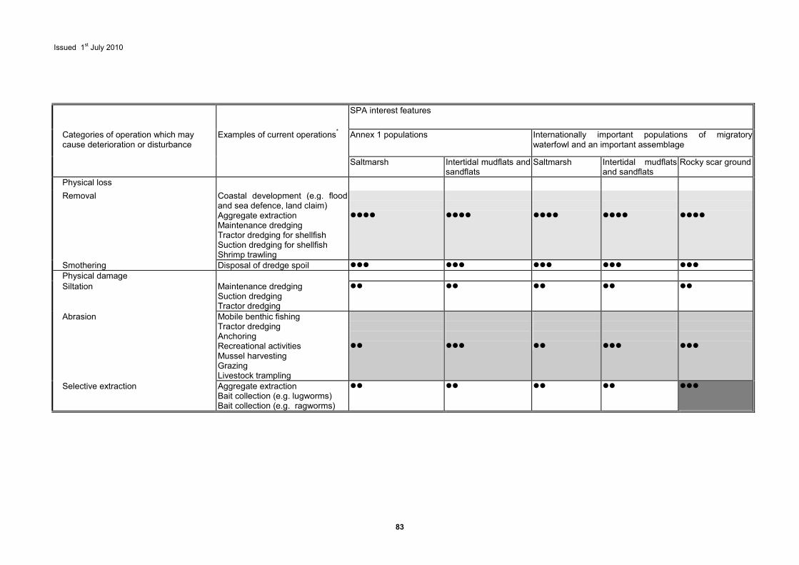
Issued 1st July 2010
83
SPA interest features
Categories of operation which may cause deterioration or disturbance
Examples of current operations* Annex 1 populations Internationally important populations of migratory waterfowl and an important assemblage
Saltmarsh Intertidal mudflats and sandflats
Saltmarsh Intertidal mudflats and sandflats
Rocky scar ground
Physical loss
Removal Coastal development (e.g. flood and sea defence, land claim) Aggregate extraction Maintenance dredging Tractor dredging for shellfish Suction dredging for shellfish Shrimp trawling
����
����
����
����
����
Smothering Disposal of dredge spoil ��� ��� ��� ��� ��� Physical damage Siltation Maintenance dredging
Suction dredging Tractor dredging
�� �� �� �� ��
Abrasion Mobile benthic fishing Tractor dredging Anchoring Recreational activities Mussel harvesting Grazing Livestock trampling
��
���
��
���
���
Selective extraction Aggregate extraction Bait collection (e.g. lugworms) Bait collection (e.g. ragworms)
�� �� �� �� ���

Issued 1st July 2010
84
SPA interest features
Categories of operation which may cause deterioration or disturbance
Examples of current operations* Annex 1 populations Internationally important populations of migratory waterfowl and an important assemblage
Saltmarsh Intertidal mudflats and sandflats
Saltmarsh Intertidal mudflats and sandflats
Rocky scar ground
Non- physical disturbance
Noise Wildfowling Recreational activities (e.g. off-road vehicles, jet skis) Low flying aircraft
���� ���� ���� ���� ����
Visual Recreational activities (e.g. boating, windsurfing) Recreational activities (e.g. dog walking, bird watching, bait collection)
���� ���� ���� ���� ����
Toxic contamination Introduction of synthetic compounds Industrial effluent discharges ��� ��� ��� ��� ��� Introduction of non-synthetic compounds Effluent and sewage discharges
containing heavy metals ��� ��� ��� ��� ���
Introduction of radionuclides Power station discharges �� �� �� �� �� Non- toxic contamination Nutrient enrichment Effluent and sewage discharge
Agricultural effluents / run off ���� ���� ���� ���� ����
Organic enrichment Untreated effluent discharge Localised organic enrichment (e.g. animal dung)
�� ��� �� ��� ���
Change in thermal regime Discharge of warm water (e.g. from a power station)
� � � � ��
Change in turbidity Suction or tractor dredging � � � � � Change in salinity Water abstraction from inflowing
rivers � �� � �� �
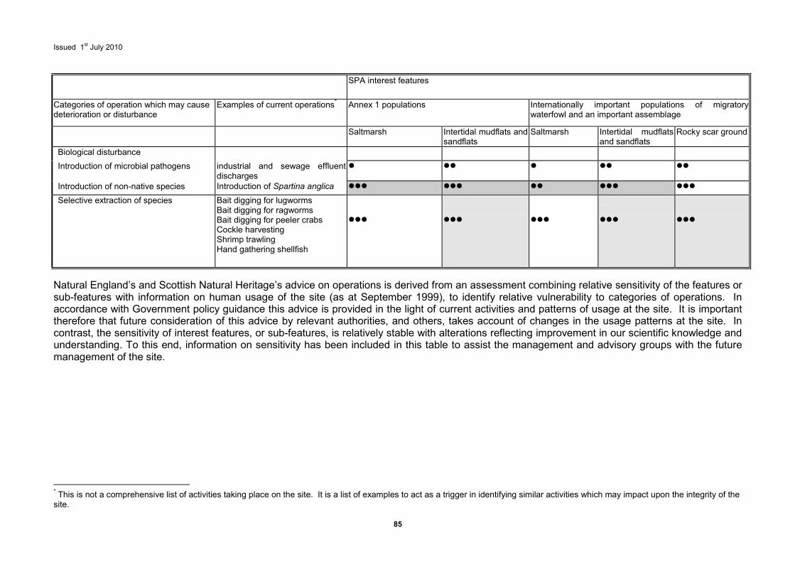
Issued 1st July 2010
85
SPA interest features
Categories of operation which may cause deterioration or disturbance
Examples of current operations* Annex 1 populations Internationally important populations of migratory waterfowl and an important assemblage
Saltmarsh Intertidal mudflats and sandflats
Saltmarsh Intertidal mudflats and sandflats
Rocky scar ground
Biological disturbance
Introduction of microbial pathogens industrial and sewage effluent discharges
� �� � �� ��
Introduction of non-native species Introduction of Spartina anglica ��� ��� �� ��� ���
Selective extraction of species Bait digging for lugworms Bait digging for ragworms Bait digging for peeler crabs Cockle harvesting Shrimp trawling Hand gathering shellfish
���
���
���
���
���
Natural England’s and Scottish Natural Heritage’s advice on operations is derived from an assessment combining relative sensitivity of the features or sub-features with information on human usage of the site (as at September 1999), to identify relative vulnerability to categories of operations. In accordance with Government policy guidance this advice is provided in the light of current activities and patterns of usage at the site. It is important therefore that future consideration of this advice by relevant authorities, and others, takes account of changes in the usage patterns at the site. In contrast, the sensitivity of interest features, or sub-features, is relatively stable with alterations reflecting improvement in our scientific knowledge and understanding. To this end, information on sensitivity has been included in this table to assist the management and advisory groups with the future management of the site.
* This is not a comprehensive list of activities taking place on the site. It is a list of examples to act as a trigger in identifying similar activities which may impact upon the integrity of the site.
Issued 1st July 2010
10 Bibliography
Black, D.L., Hansom, J.D. & Comber, D.P.M. 1994. Estuaries management plans, coastal processes and conservation, Solway Firth. Natural England Report. Contract No. F70-01-90. Peterborough.
British Nuclear Fuels PLC. 1993. Environmental appraisal, terrestrial ecology Chaplecross and environs. Ove Arup.
Brown, A.E., Burn, A.J., Hopkins, J.J., and Way, S.F. 1997. The Habitats Directive: selection of Special Areas of Conservation in the UK. JNCC Report, No 270.
Burd, F. 1987. South west saltmarsh survey of Great Britain, Scotland Report.
Connor, D.W., Brazier, D.P., Hill, T.O. & Northen, K.O. 1997. Marine Nature Conservation Review: marine biotope classification for Britain and Ireland. Volume 1. Littoral biotopes. Version 97.06. Joint Nature Conservation Committee Report, No. 229.
Connor, D.W., Dalkin, M.J., Hill, T.O., Holt, R.H.F. & Sanderson, W.G. 1997. Marine Nature Conservation Review: marine biotope classification for Britain and Ireland. Volume 2. Sublittoral biotopes. Version 97.06. Joint Nature Conservation Committee Report, No. 230.
Covey, R. and Emblow, C.S. 1992. Littoral survey of the Solway and additional sites in Dumfries and Galloway. JNCC Report, No 33.
Cutts, N. and Hemingway, K. 1996. The Solway Firth broad scale habitat mapping. Institute of Estuarine and Coastal Studies, University of Hull, Report to SNH. Unpublished report.
Cutts, N., Allen, J., Elliott, M., Hemingway, K. and Read, S. 1999. Intertidal Scar ground mapping of the Solway Firth. Report to SNH. Unpublished report.
DEFRA. November 2006. Ramsar sites in England – A Policy Statement.
DETR & The Welsh Office. 1998. European marine sites in England and Wales. A guide to the Conservation (Natural Habitats &c.) Regulations 1994 and to the preparation and application of management schemes. London.
Elliott, M., Nedwell, S., Jones, N.V., Read, S.J., Cutts, N.D., Hemingway, K.L. 1998. Intertidal sand and mudflats and subtidal mobile sandbanks (volume II). An overview of dynamics and sensitivity characteristics for conservation management of marine SACs. Scottish Association for Marine Science (UK Marine SACS Project).
EN, SNH, EHS(DOE(NI)), CCW, JNCC & SAMS, (1998). Natura 2000: European marine sites: Guidance relating to statutory conservation objectives and operations which may cause deterioration or disturbance. Peterborough.
Hemingway, K.L., Cutts, N.D., Thomson, S., Allen, J.H. and Burdon, D. (2006) Biological Survey of the Intertidal Sediments of the Solway Firth. Report ZBB643-F-2006 to English Nature
Hawker, D. 1999. Survey of Saltmarsh in Solway Firth European Marine Site. Report to SNH. Unpublished report.
Hiscock, K. 1996. Marine Nature Conservation Review: rationale and methods. JNCC. Peterborough,
Holt, T.J., Jones, D.R., Hawkins, S.J., Hartnoll, R.G. 1995. The sensitivity of marine communities to man-induced change - a scoping report. CCW Contract Science Report no.65.

Issued 1st July 2010
Lucas, M C. Greaves, R K . Bubb, D H. & Kemp, P S. (2007). Stanley Mills Lamprey Report. Scottish Natural Heritage Commissioned Report No. 256 (ROAME No. F04LH03).
Maitland, P S. 2003. Ecology of the River Brook and Sea Lamprey. Conserving Natura 2000 Rivers, Ecology Series No 5. English Nature, Peterborough. http://www.english-nature.org.uk/LIFEinUKRivers/publications/lamprey.pdf
Marine Life Information Network: Biology and Sensitivity Key Information Sub-programme [online]. Plymouth: Marine Biological Association of the United Kingdom. [cited 24/02/2005]. Available from: <http://www.marlin.ac.uk>
Marshall, J.R. 1962. Morphology of the Upper Solway saltmarshes, Scottish Geological Magazine. No 78, pp. 81-99.
Posford Duvivier Environment. 1996. Mapping the intertidal habitat and species of selected marine Special Areas of Conservation, Solway Firth SAC: Southern Side. Report to Natural England, Peterborough.
Quinn, J.L., Still, L., Carrier, M. and Lambdon, P. 1993. The distribution of waterfowl and other bird species on the Solway Firth, at Chaplecross and the Annan Catchment October 1991-July 1993. Ove Arup.
Research and Advisory Services Directorate. 1996. Natterjack toad (Bufo calamita) Species Action Plan, International and Biodiversity Branch SNH.
Scottish Natural Heritage. 2007. Scottish Marine Wildlife Watching Code
Scottish Office Environment Department. 1995. Nature Conservation: Implementation in Scotland
of EC Directives on the Conservation of Wild Flora and Fauna, and the Conservation of Wild Birds: The Conservation Regulations (Natural Habitats &c.) Regulations 1994. Circular 6/1995.
Seamap Research Group. 1999. Solway Firth - Marine SAC mapping. Subtidal sediments and Scars. Report to SNH. Solway Firth Partnership. 1996. Solway Firth Review.
Smith B, Naden P & Cooper D (2003). Siltation in Rivers. 3: Integrated Assessment Procedure. Conserving Natura 2000 Rivers Conservation Techniques Series. English Nature, Peterborough.
Issued 1st July 2010
88
11 Glossary
Abiotic Non biological, physical parameters and/or influences.
Annex I habitats A natural habitat(s) listed in Annex 1 of the Habitats Directive for which Special Areas of Conservation can be selected.
Annex II Species A species listed in Annex II of the Habitats Directive for which Special Areas of Conservation can be selected.
Annex IV Species A species listed in Annex IV of the Habitats Directive in need of strict protection.
Assemblage A collection of plants and/or animals characteristically associated with a particular environment.
Attribute Characteristic of an interest feature/sub-feature which provides an indication of the condition of the interest feature or sub-feature to which it applies.
BAP Biodiversity Action Plan.
Benthos Those organisms attached to, or living on, in or near, the seabed, including that part which is exposed by tides.
Biodiversity The total variety of life in earth. This includes diversity within species, between species and of ecosystems.
Biogeographical transitions
The gradual change in community composition due to geographical influences.
Biotope The physical habitat with its biological community; a term which refers to the combination of physical environment and its distinctive assemblage of conspicuous species.
Characteristic
Special to or especially abundant in a particular situation or biotope. Characteristic species should be immediately conspicuous and easily identified.
Circalittoral
The rocky subtidal zone below that dominated by algae (animal dominated subtidal zone).
Community A group of organisms occurring in a particular environment, presumably interacting with each other and with the environment, and identifiable by means of ecological survey from other groups.
Competent authority
Any minister, government department, public or statutory undertaker, public body or person holding a public office that exercises legal powers (see also relevant authority).
Conservation objective
A statement of the nature conservation aspirations for the site expressed in terms of the favourable condition that we wish to see the species and/or habitats for which the site has been selected to attain. Conservation objectives for European marine sites relate to the aims of the Habitats Directive.
Eulittoral The main part of the intertidal zone characterised by limpets, barnacle, mussels, fucoid algae and with red algae often on the lower part.
European marine site
A European site (SAC or SPA) which consists of, or in so far as it consists of, marine areas.
Issued 1st July 2010
89
Favourable Condition
A range of conditions for a natural habitat or species at which the sum of the influences acting upon that habitat or species are not adversely affecting its distribution, abundance, structure or function within an individual Natura 2000 site in the long term. The condition in which the habitat or species is capable of sustaining itself on a long term basis.
Favourable conservation status
A range of conditions for a natural habitat or species at which the sum of influences acting upon that habitat or species are not adversely affecting its distribution, abundance, structure or function through the EC in the long term. The condition in which the habitats or species is capable of sustaining itself on a long term basis.
Flocculation The action of clay particles sticking together in saline conditions, effectively increasing particle size, encouraging settlement.
Fluvial Produced by rivers, fluvial sediments are bought into the system by rivers.
GIS Geographical Information systems. A system for capturing, storing, checking, integrating, manipulating analysing and displaying digital data which are spatially referenced to a geographical region.
Geomorphology The study of the form of the earth’s crust and the processes which shape the physical features of the earth’s surface. In estuarine terms this means the form and function of the estuary and its inter-relationship with processes elsewhere.
Habitat The place in which an animal or plant lives.
Habitats Directive The abbreviated term for Council Directive 92/43/EEC of 21 May 1992 on the Conservation of Natural Habitats and of Wild Fauna and Flora. It is the aim of this Directive to promote the conservation of certain habitats and species within the European Union.
Halophyte A plant which is adapted to life in saline conditions.
Infralittoral
The subtidal zone in which upward facing rocks are dominated by erect algae, typically kelps.
Integrity The coherence of the sites’ ecological structure and function, across its whole area, that enables it to sustain the habitat, complex of habitats and/or levels of populations of the species for which it was classified.
Qualifying Interest Feature
A natural or semi-natural feature for which a European site has been selected. This includes the Habitats Directive Annex 1 habitat, or specific component of their fauna and flora, or any Annex II species and any population of bird species for which an SPA has been designated under the Birds Directive. Any habitat of a species for which the site has been selected, or typical species of an Annex 1 habitat are also considered to be interest features.
Isostatic uplift The upwards movement of land in relation to the sea.
Littoral The margins of a body of water, an area which is occasionally washed by the tide.
Maintain The action required for an interest feature when it is considered to be in favourable condition.
Management group The body of relevant authorities formed to manage the European marine site.
Issued 1st July 2010
90
Management scheme
The framework established by the relevant authorities at a European marine site under which their functions are exercised to secure, in relation to that site, compliance with the requirements of the Habitats Directive.
Nationally scarce/rare
For marine purposes, these are regarded as species of limited national occurrence.
Natura 2000
The European network of protected sites established under the Birds Directive and the Habitats Directive.
NVC National Vegetation Classification - a classification system for plant communities to provide standardised descriptions of names and systematically arranged vegetation types from all natural, semi-natural and major artificial habitats in England, Scotland and Wales, using a standard methodology.
Operations which may cause deterioration or disturbance
Any activity or operation taking place within, adjacent to, or remote from a European marine site that has the potential to cause deterioration to the natural habitats for which the site was designated or disturbance to the species and its habitats for which the site was designated.
Plan or project The definition of plan or project has a broad interpretation. In general, any operation which requires an application to be made for specific statutory consent, authorisation, licence or other permission. Specifically, any proposed development that is within a relevant authority’s function to control, or over which a competent authority has a statutory function to decide on applications for consents, authorisations, licences or permissions. The Habitats Directive (Article 6.3) requires that any plan or project likely to have a significant effect upon a Natura site shall be subject to an appropriate assessment.
Ramsar site A site held on the list of wetlands of international importance, especially as habitats for wildfowl, under the Ramsar convention.
Relevant authority The specific competent authority which has powers or functions which have, or could have, an impact on the marine environment within or adjacent to a European marine site.
Restore The action required for an interest when it is not considered to be in a favourable condition.
Saltmarsh terrace Terraces formed during rapid stages of salt marsh development and isostatic uplift of land.
Saltpan A hollow within saltmarsh once filled with water which has evaporated, leaving behind a saltpan.
Sediment budget Sediment within the system, being imported or lost.
Sensitivity The intolerance of a habitat, community or individual of a species to damage from an external factor.
Special Area of Conservation (SAC)
An area designated under the European Habitats Directive 92/43/EEC.
Special Protection Area (SPA)
An area designated under the European Birds Directive 79/409/EEC.
Sublittoral An area constantly covered by the sea.

Issued 1st July 2010
91
Typical species A species and its habitat that is considered to be a typical component of an
interest feature.
Vulnerability The exposure of a habitat, community or individual of a species to an external factor to which it is sensitive.
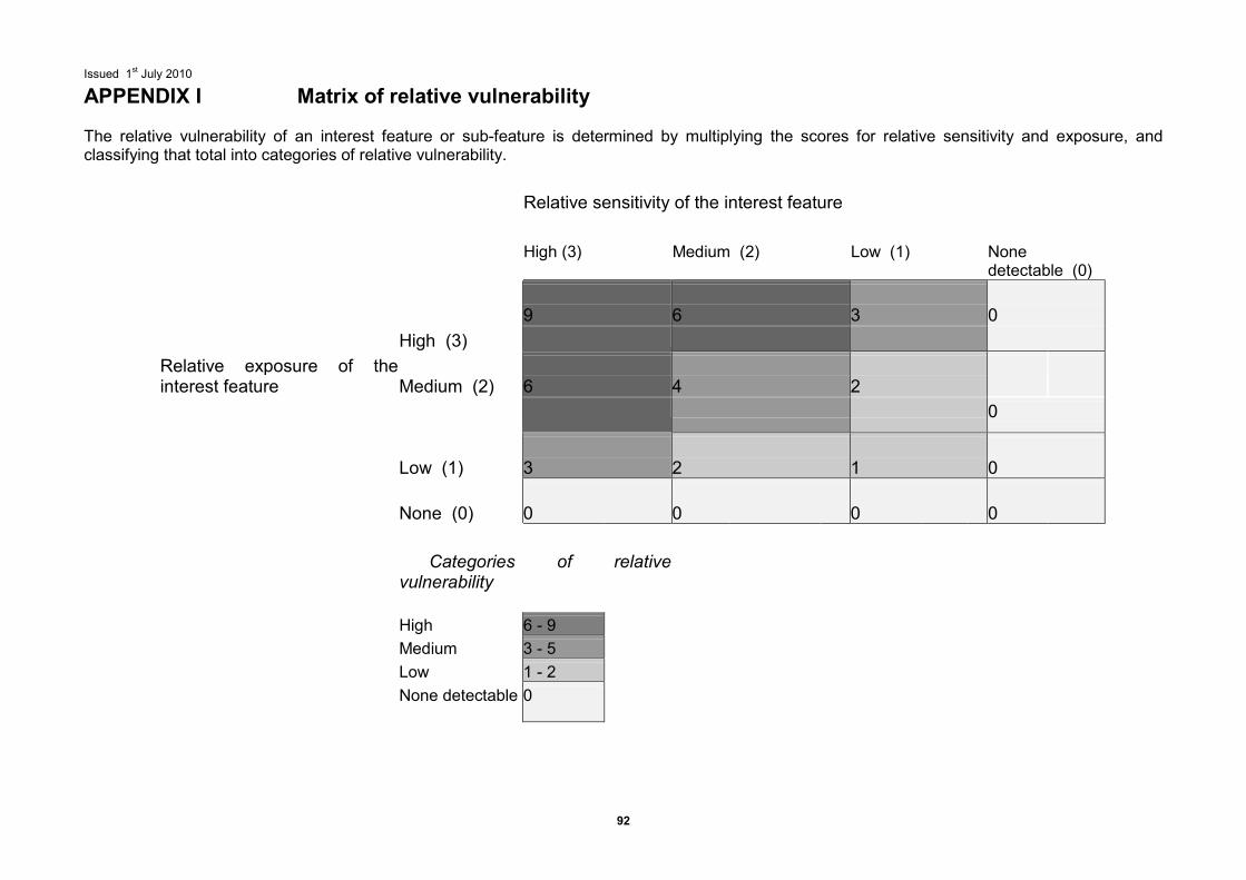
Issued 1st July 2010
92
APPENDIX I Matrix of relative vulnerability The relative vulnerability of an interest feature or sub-feature is determined by multiplying the scores for relative sensitivity and exposure, and classifying that total into categories of relative vulnerability.
Relative sensitivity of the interest feature
High (3)
Medium (2)
Low (1)
None detectable (0)
9
6
3
0
High (3)
Relative exposure of the interest feature
Medium (2)
6
4
2
0
Low (1)
3
2
1
0
None (0)
0
0
0
0
Categories of relative vulnerability
High
6 - 9
Medium
3 - 5
Low
1 - 2
None detectable
0
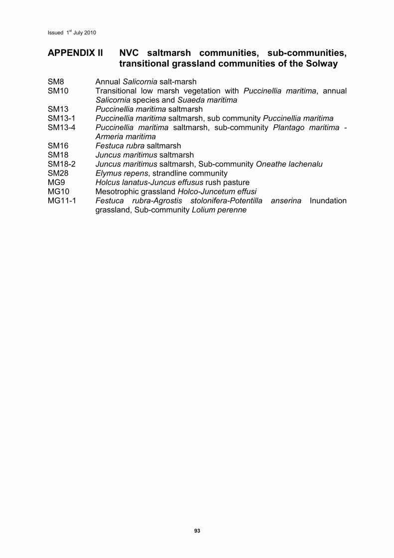
Issued 1st July 2010
93
APPENDIX II NVC saltmarsh communities, sub-communities, transitional grassland communities of the Solway
SM8 Annual Salicornia salt-marsh SM10 Transitional low marsh vegetation with Puccinellia maritima, annual
Salicornia species and Suaeda maritima SM13 Puccinellia maritima saltmarsh SM13-1 Puccinellia maritima saltmarsh, sub community Puccinellia maritima SM13-4 Puccinellia maritima saltmarsh, sub-community Plantago maritima -
Armeria maritima SM16 Festuca rubra saltmarsh SM18 Juncus maritimus saltmarsh SM18-2 Juncus maritimus saltmarsh, Sub-community Oneathe lachenalu SM28 Elymus repens, strandline community MG9 Holcus lanatus-Juncus effusus rush pasture MG10 Mesotrophic grassland Holco-Juncetum effusi MG11-1 Festuca rubra-Agrostis stolonifera-Potentilla anserina Inundation
grassland, Sub-community Lolium perenne
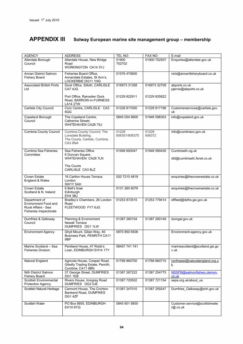
Issued 1st July 2010
94
APPENDIX III Solway European marine site management group – membership
AGENCY ADDRESS TEL NO: FAX NO: E-mail Allerdale Borough Council
Allerdale House, New Bridge Road WORKINGTON CA14 3YJ
01900 702702
01900 702507 [email protected]
Annan District Salmon Fishery Board
Fisheries Board Office, Annandale Estates, St Ann’s, LOCKERBIE DG11 1HQ
01576 470600 [email protected]
Associated British Ports Ltd
Dock Office, Silloth, CARLISLE CA7 4JQ Port Office, Ramsden Dock Road, BARROW-in-FURNESS LA14 2TW
016973 31358 01229 822911
016973 32709 01229 835822
abports.co.uk [email protected]
Carlisle City Council Civic Centre, CARLISLE. CA3 8QG
01228 817000 01228 817199 [email protected]
Copeland Borough Council
The Copeland Centre, Catherine Streetr, WHITEHAVEN CA28 7SJ
0845 054 8600 01946 598303 [email protected]
Cumbria County Council Cumbria County Council, The Lonsdale Building, The Courts, Carlisle, Cumbria, CA3 8NA
01228 606351/606375
01228 606372
Cumbria Sea Fisheries Committee
Sea Fisheries Office 6 Duncan Square, WHITEHAVEN CA28 7LN The Courts CARLISLE CA3 8LZ
01946 693047
01946 590430 Cumbriasfc.og.uk [email protected]
Crown Estate England & Wales
16 Carlton House Terrace London SW1Y 5AH
020 7210 4818 [email protected]
Crown Estate Scotland & N. Ireland
6 Bell’s brae Edinburgh EH4 3BJ
0131 260 6076 [email protected]
Department of Environment Food and Rural Affairs - Sea Fisheries Inspectorate
Bradley’s Chambers, 26 London Road FLEETWOOD FY7 6JG
01253 873515 01253 779414 [email protected]
Dumfries & Galloway Council
Planning & Environment Newall Terrace DUMFRIES DG1 1LW
01387 260154
01387 260149 dumgal.gov.uk
Environment Agency Ghyll Mount, Gilian Way, 40 Business Park, PENRITH CA11 9BP
0870 850 6506 Environment-agency.gov.uk
Marine Scotland – Sea Fisheries Division
Pentland House, 47 Robb’s Loan, EDINBURGH EH14 1TY
08457 741 741 [email protected]
Natural England Agricola House, Cowper Road, Gilwilly Trading Estate, Penrith, Cumbria, CA11 9BN
01768 860700 01768 860710 [email protected]
Nith District Salmon Fishery Board
37 George Street, DUMFRIES DG1 1EB
01387 267222 01387 254775 [email protected]
Scottish Environmental Protection Agency
Rivers House, Irongray Road DUMFRIES DG2 0JE
01387 720502 01387 721154 sepa.org.uk/about_us
Scottish Natural Heritage Carmont House, The Crichton Bankend Road, DUMFRIES DG1 4ZF
01387 247010 01387 259247 [email protected]
Scottish Water PO Box 8855, EDINBURGH EH10 6YQ
0845 601 8855 Customer.service@[email protected]
Issued 1st July 2010
95
APPENDIX IV Plans and Projects Regulations 48-53 outline the procedures which must be carried out when considering all plans and projects. Proposals which would constitute “plans or projects” in the context of Article 6.3 of the Habitats Directive can include a wide range of activities, e.g. from applications for planning consent or discharge consent, through to applications for consent on a SSSI, grant applications, promotional material and signage. An appropriate assessment needs to be undertaken in respect of any plan or project which: a. either alone or in combination with other plans or projects would be likely to have a
significant effect on a European Site; and b. is not directly connected with the management of the site for nature conservation. An appropriate assessment is required by law for all plans and projects that are likely to significantly affect a European Site (Regulation 48) to determine the impacts of the proposal upon the site interests and specifically to ascertain whether it will adversely affect the site’s integrity in view of the site’s conservation objectives. The appropriate assessment comprises two phases.
1 a scientific appraisal of the impact of the proposals on the Qualifying Interests 2 a decision making process based on the appraisal.
NE and SNH will advise on the scope of the appraisal to inform the decision. Determining whether a plan or project will not have an adverse effect upon site integrity will always be a matter for scientific judgement, depending upon a number of factors which will vary from case to case. Assessment of the plan or project against the conservation objectives will always be part of this process. Hence, there must be reference to the effects on the qualifying interests either indirectly through effects on the ecological factors on which they depend, e.g. a species’ habitat, hydrology etc., or directly e.g. through loss of qualifying habitat. The scale of such effects should be taken into account; for example, will such effects reduce the ability of the site to maintain the qualifying habitats or species? Tables 4 and 5 provide relevant authorities with a guide against which to initiate an assessment of the ‘significance’ of any plans or projects (and ongoing operations or activities) proposed for the site; although this will only be the starting point for assessing impacts and does not remove the need for relevant authorities to formally consult NE or SNH as appropriate, over individual plans and projects where required under the Regulations. The Habitat Regulations also require public bodies, in meeting their obligation to avoid deterioration and/or significant disturbance and to review existing decisions and consents (regulation 50).
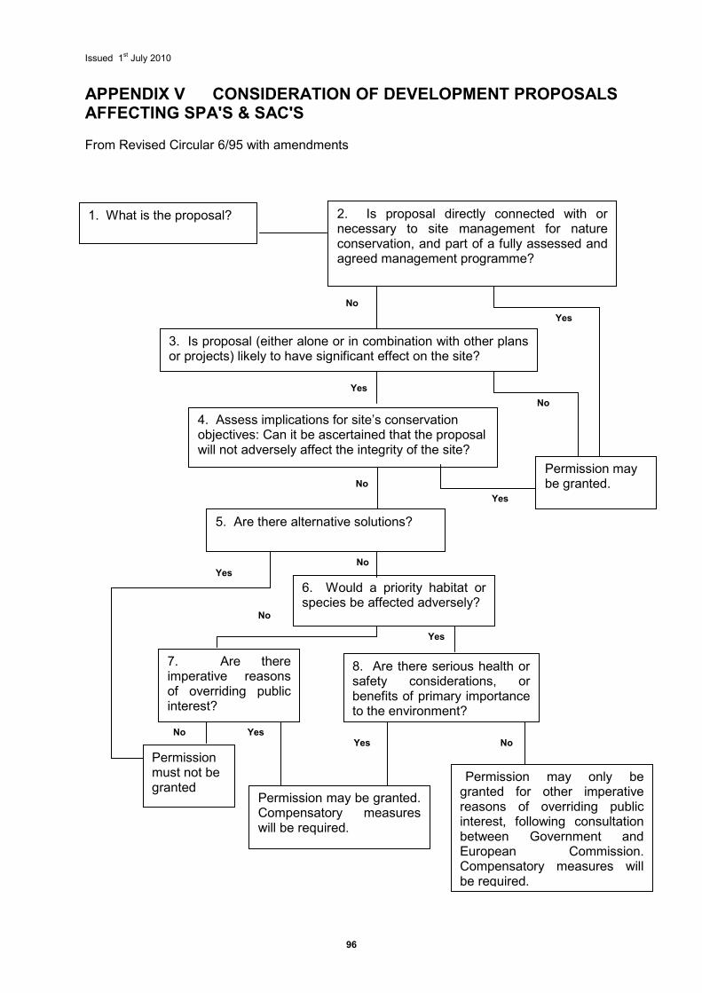
Issued 1st July 2010
96
APPENDIX V CONSIDERATION OF DEVELOPMENT PROPOSALS AFFECTING SPA'S & SAC'S From Revised Circular 6/95 with amendments
No No Yes
Yes
No
Yes
Yes
No
Yes
No
Yes
Yes
No
1. What is the proposal? 2. Is proposal directly connected with or necessary to site management for nature conservation, and part of a fully assessed and agreed management programme?
3. Is proposal (either alone or in combination with other plans or projects) likely to have significant effect on the site?
4. Assess implications for site’s conservation objectives: Can it be ascertained that the proposal will not adversely affect the integrity of the site?
5. Are there alternative solutions?
6. Would a priority habitat or species be affected adversely?
7. Are there imperative reasons of overriding public interest?
8. Are there serious health or safety considerations, or benefits of primary importance to the environment?
Permission must not be granted
Permission may only be granted for other imperative reasons of overriding public interest, following consultation between Government and European Commission. Compensatory measures will be required.
Permission may be granted. Compensatory measures will be required.
Permission may be granted.
No
Issued 1st July 2010
97

Issued 1st July 2010
98
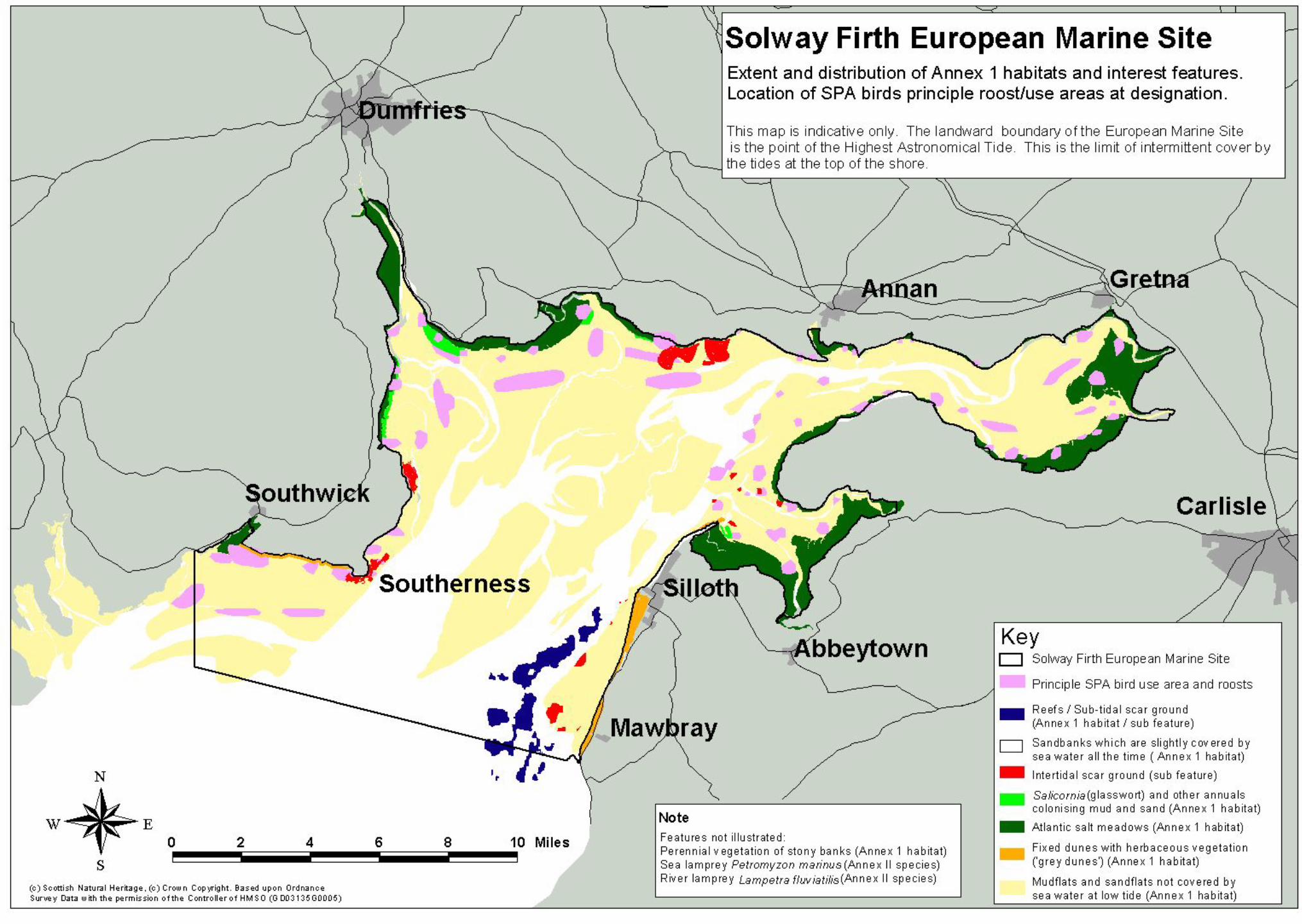

UK SPA data form
Upper Solway Flats and Marshes Standard Natura 2000 Data Form Produced by JNCC. Version 1.1, 05/05/06 Page 1 of
NATURA 2000 STANDARD DATA FORM
FOR SPECIAL PROTECTION AREAS (SPA) FOR SITES ELIGIBLE FOR IDENTIFICATION AS SITES OF COMMUNITY IMPORTANCE (SCI)
AND FOR SPECIAL AREAS OF CONSERVATION (SAC)
1. Site identification: 1.1 Type H 1.2 Site code UK9005012
1.3 Compilation date 199211 1.4 Update 199902
1.5 Relationship with other Natura 2000 sites
U K 0 0 1 3 0 2 5 1.6 Respondent(s) International Designations, JNCC, Peterborough
1.7 Site name Upper Solway Flats and Marshes
1.8 Site indication and designation classification dates date site proposed as eligible as SCI date confirmed as SCI date site classified as SPA 199211 date site designated as SAC
2. Site location: 2.1 Site centre location longitude latitude 03 25 27 W 54 54 20 N
2.2 Site area (ha) 43636.73 2.3 Site length (km)
2.5 Administrative region
NUTS code Region name % cover
UK12 Cumbria 31.03% UKA21 Dumfries and Galloway 68.97%
2.6 Biogeographic region
X Alpine Atlantic Boreal Continental Macaronesia Mediterranean
3. Ecological information:
3.1 Annex I habitats Habitat types present on the site and the site assessment for them:
Annex I habitat % cover Representativity
Relative surface
Conservation status
Global assessment
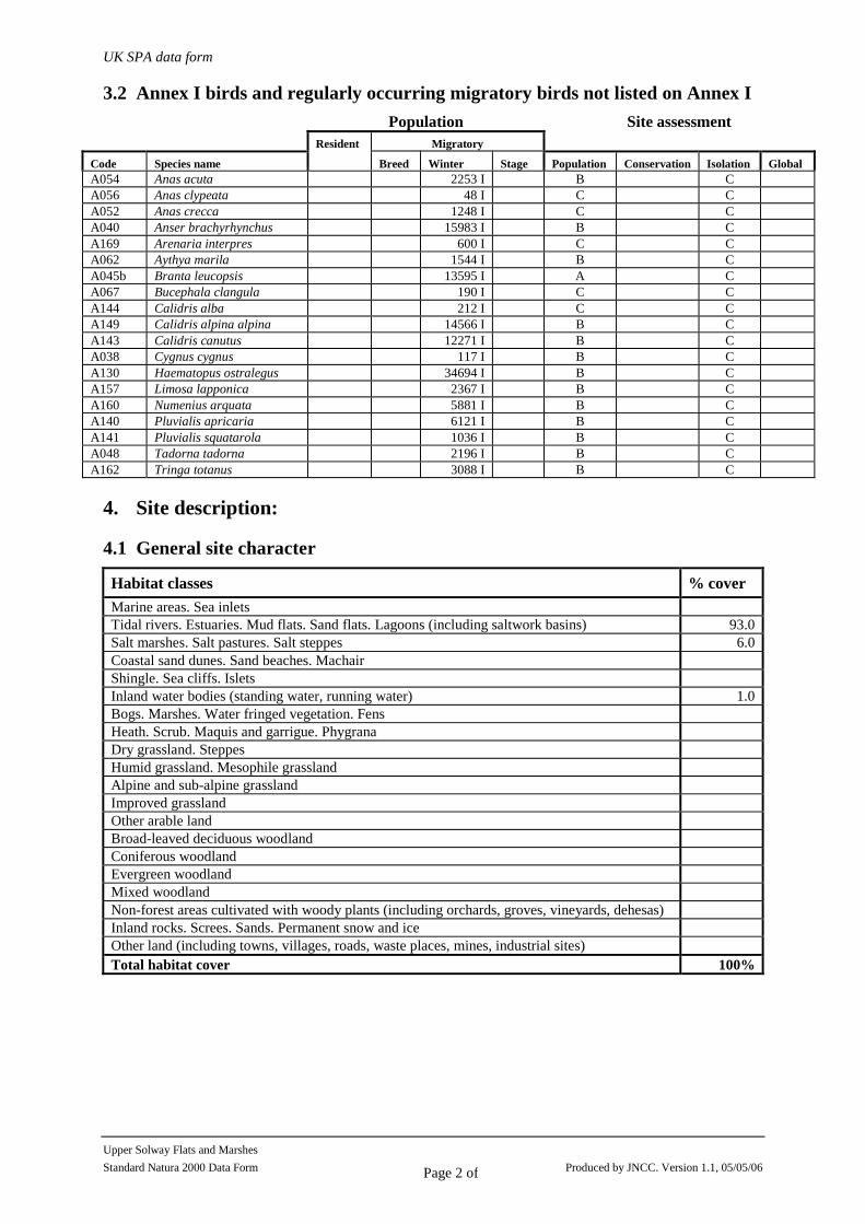
UK SPA data form
Upper Solway Flats and Marshes Standard Natura 2000 Data Form Produced by JNCC. Version 1.1, 05/05/06 Page 2 of
3.2 Annex I birds and regularly occurring migratory birds not listed on Annex I Population Site assessment
Migratory
Code Species name
Resident
Breed Winter Stage Population Conservation Isolation Global A054 Anas acuta 2253 I B C A056 Anas clypeata 48 I C C A052 Anas crecca 1248 I C C A040 Anser brachyrhynchus 15983 I B C A169 Arenaria interpres 600 I C C A062 Aythya marila 1544 I B C A045b Branta leucopsis 13595 I A C A067 Bucephala clangula 190 I C C A144 Calidris alba 212 I C C A149 Calidris alpina alpina 14566 I B C A143 Calidris canutus 12271 I B C A038 Cygnus cygnus 117 I B C A130 Haematopus ostralegus 34694 I B C A157 Limosa lapponica 2367 I B C A160 Numenius arquata 5881 I B C A140 Pluvialis apricaria 6121 I B C A141 Pluvialis squatarola 1036 I B C A048 Tadorna tadorna 2196 I B C A162 Tringa totanus 3088 I B C
4. Site description:
4.1 General site character
Habitat classes % cover Marine areas. Sea inlets Tidal rivers. Estuaries. Mud flats. Sand flats. Lagoons (including saltwork basins) 93.0Salt marshes. Salt pastures. Salt steppes 6.0Coastal sand dunes. Sand beaches. Machair Shingle. Sea cliffs. Islets Inland water bodies (standing water, running water) 1.0Bogs. Marshes. Water fringed vegetation. Fens Heath. Scrub. Maquis and garrigue. Phygrana Dry grassland. Steppes Humid grassland. Mesophile grassland Alpine and sub-alpine grassland Improved grassland Other arable land Broad-leaved deciduous woodland Coniferous woodland Evergreen woodland Mixed woodland Non-forest areas cultivated with woody plants (including orchards, groves, vineyards, dehesas) Inland rocks. Screes. Sands. Permanent snow and ice Other land (including towns, villages, roads, waste places, mines, industrial sites) Total habitat cover 100%
UK SPA data form
Upper Solway Flats and Marshes Standard Natura 2000 Data Form Produced by JNCC. Version 1.1, 05/05/06 Page 3 of
4.1 Other site characteristics
Soil & geology: Biogenic reef, Igneous, Limestone, Mud, Pebble, Sand, Sandstone, Shingle
Geomorphology & landscape: Coastal, Estuary, Intertidal rock, Intertidal sediments (including sandflat/mudflat), Lowland, Shingle bar, Subtidal sediments (including sandbank/mudbank)
4.2 Quality and importance
ARTICLE 4.1 QUALIFICATION (79/409/EEC) Over winter the area regularly supports:
Branta leucopsis (Svalbard/Denmark/UK)
112.2% of the GB population 5 year peak mean 1991/92-1995/96
Cygnus cygnus (Iceland/UK/Ireland)
2.1% of the GB population 5 year peak mean 1991/92-1995/96
Limosa lapponica (Western Palearctic - wintering)
4.5% of the GB population 5 year peak mean 1991/92-1995/96
Pluvialis apricaria (North-western Europe - breeding)
2.4% of the GB population 5 year peak mean 1991/92-1995/96
ARTICLE 4.2 QUALIFICATION (79/409/EEC) Over winter the area regularly supports:
Anas acuta (North-western Europe)
3.8% of the population 5 year peak mean 1991/92-1995/96
Anas clypeata (North-western/Central Europe)
0.5% of the population in Great Britain 5 year peak mean 1991/92-1995/96
Anas crecca (North-western Europe)
0.9% of the population in Great Britain 5 year peak mean 1991/92-1995/96
Anser brachyrhynchus (Eastern Greenland/Iceland/UK)
7.1% of the population 5 year peak mean 1991/92-1995/96
Arenaria interpres (Western Palearctic - wintering)
0.9% of the population in Great Britain 5 year peak mean, 1986/7-1990/1
Aythya marila (Northern/Western Europe)
0.5% of the population 5 year peak mean 1991/92-1995/96
Bucephala clangula (North-western/Central Europe)
1.1% of the population in Great Britain 5 year peak mean 1991/92-1995/96
Calidris alba (Eastern Atlantic/Western & Southern Africa - wintering)
0.9% of the population in Great Britain 5 year peak mean 1991/92-1995/96
Calidris alpina alpina (Northern Siberia/Europe/Western Africa)
2.7% of the population in Great Britain 5 year peak mean 1991/92-1995/96

UK SPA data form
Upper Solway Flats and Marshes Standard Natura 2000 Data Form Produced by JNCC. Version 1.1, 05/05/06 Page 4 of
Calidris canutus (North-eastern Canada/Greenland/Iceland/North-western Europe)
3.6% of the population 5 year peak mean 1991/92-1995/96
Haematopus ostralegus (Europe & Northern/Western Africa)
4% of the population 5 year peak mean 1991/92-1995/96
Numenius arquata (Europe - breeding)
1.7% of the population 5 year peak mean 1991/92-1995/96
Pluvialis squatarola (Eastern Atlantic - wintering)
2.4% of the population in Great Britain 5 year peak mean 1991/92-1995/96
Tadorna tadorna (North-western Europe)
3% of the population in Great Britain 5 year peak mean 1991/92-1995/96
Tringa totanus (Eastern Atlantic - wintering)
1.7% of the population 5 year peak mean 1991/92-1995/96
ARTICLE 4.2 QUALIFICATION (79/409/EEC): AN INTERNATIONALLY IMPORTANT ASSEMBLAGE OF BIRDS
Over winter the area regularly supports: 133440 waterfowl (5 year peak mean 01/11/1998) Including: Cygnus cygnus , Anser brachyrhynchus , Branta leucopsis , Tadorna tadorna , Anas crecca , Anas acuta , Anas clypeata , Aythya marila , Bucephala clangula , Haematopus ostralegus , Pluvialis apricaria , Pluvialis squatarola , Calidris canutus , Calidris alba , Calidris alpina alpina , Limosa lapponica , Numenius arquata , Tringa totanus , Arenaria interpres .
4.3 Vulnerability A management strategy for the site has been produced by the Solway Firth Partnership. The strategy addresses threats to the SPA interest on the site and sets out the means by which it is proposed to secure the sustainable use of the Firth. There has been relatively little land claim compared with most other estuaries in the UK but some established and new flood defence and coastal erosion works may exacerbate erosion elsewhere within the site. The cockle fishery has been closed for a number of years due to overexploitation and the other commercial, traditional and shell fisheries are regulated by Government to ensure that they are carried out in a sustainable way and that their impact on bird feeding areas are not significant. Roosts and feeding areas are vulnerable to disturbance and the management strategy adddresses the planning of recreational and development activities to avoid disturbance to roosts and feeding areas.
5. Site protection status and relation with CORINE biotopes:
5.1 Designation types at national and regional level Code % cover
UK01 (NNR) 16.9 UK04 (SSSI/ASSI) 100.0