Embed Size (px)
Citation preview
31st Executive Committee – 8-9 July 2014 Document 5
Interim Report of the Implementation Plan Working Group:
Towards the 10-Year Implementation Plan 2016-2025
To respond to the Ministers‟ request at the Geneva Summit in January 2014, an Implementation Plan
Working Group (IPWG) has been established to draft a new 10-year Implementation Plan (2016-2025)
for initial review at the GEO-XI Plenary in November 2014 and for acceptance at the GEO-XII
Plenary, and subsequent endorsement at the associated Ministerial Summit, at the end of 2015.
Nominations to the IPWG were forwarded by each caucus; the GEO Co-Chairs reviewed these
nominations and proposed the composition of the Group that was then endorsed by the GEO
Executive Committee on 31 March 2014.
The GEO Executive Committee and GEO Co-Chairs received the mandate from the Plenary to oversee
and steer the process of developing the new 10-year Implementation Plan and they agreed to a two-
phase approach to guide the IPWG work an initial reflective phase, followed by a longer 'synthesis and
formulation' phase.
The initial reflective phase – or 'fresh perspectives' exercise – started with the 1st IPWG face to face
meeting on 10-11 April 2014 and ended with the submission to the GEO Executive Committee of this
Interim Report, which summarizes the results of the IPWG work.
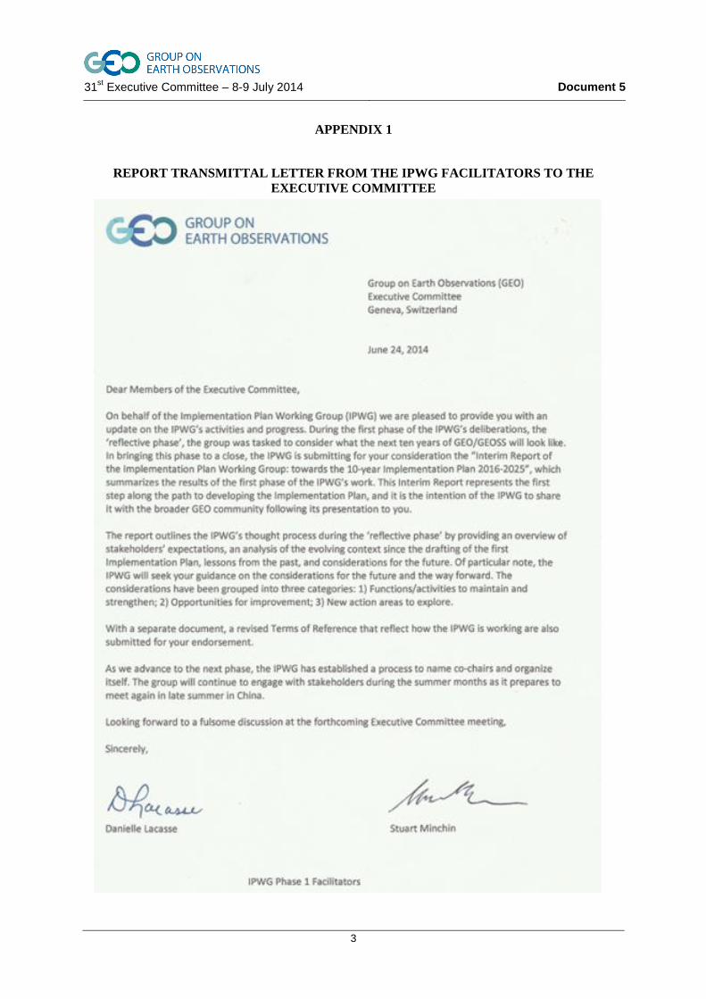
The Interim Report is officially transmitted to the Executive Committee by the two IPWG Facilitators
(transmittal letter in Appendix 1).
The Interim Report is enclosed as Appendix 2.
The Executive Committee is requested to comment on the Interim Report and provide further
guidance to the Implementation Plan Working Group on the development of the new
Implementation Plan 2016-2025.
31st Executive Committee – 8-9 July 2014 Document 5
2
INTENTIONALLY LEFT BLANK
31st Executive Committee – 8-9 July 2014 Document 5
3
APPENDIX 1
REPORT TRANSMITTAL LETTER FROM THE IPWG FACILITATORS TO THE
EXECUTIVE COMMITTEE
31st Executive Committee – 8-9 July 2014 Document 5
4
APPENDIX 2
INTERIM REPORT OF THE IMPLEMENTATION PLAN WORKING GROUP
TOWARDS THE 10 YEAR IMPLEMENTATION PLAN 2016-2025
31st Executive Committee – 8-9 July 2014 Document 5
5
INTERIM REPORT OF THE IPWG:
TOWARDS THE 10 YEAR IMPLEMENTATION PLAN 2016 -2025
PREFACE
In writing this report, members of the Implementation Plan Working Group (IPWG) have attempted to
highlight key messages about what needs to change in GEO as it embarks in its second decade. In
doing so, the IPWG has tried to reach a balance between outlining our successes and areas where
improvement is needed. As part of the GEO community IPWG members are proud of what has been
accomplished, how far GEO has come since 2005 and fully appreciate the engagement and wisdom
that other members of the Community have brought to this process. GEO/GEOSS is a success story,
full of energy and dynamism and well on the way to maturity. The IPWG is relying on the
community‟s contribution to help us make a good plan for the next 10 years so the success story
continues.
TABLE OF CONTENTS
1 INTRODUCTION
2 DRIVERS FOR CHANGE, CONSULTATION WITH STAKEHOLDERS, LESSONS
LEARNED AND STRENGTHS WEAKNESSES OPPORTUNITIES AND THREATS
2.1 Input from the GEO community to the fresh perspectives phase of the GEO
Implementation plan
2.2 Drivers for change: A scan of key external trends affecting GEO in the last ten
years
2.2.1 Advances in Science and Technology
2.2.2 Environmental Change
2.2.3 Political, Social and Economic Changes
2.3 Internal factors - Common threads and lessons learnt
3 DESTINATION 2025: CONSIDERATIONS FOR THE FUTURE
4 CONCLUSION: KEY TAKE AWAY MESSAGES FOR THE GEO EXECUTIVE
COMMITTEE
4.1 Maintain and strengthen
4.2 Opportunities for improvement
4.3 Fresh perspectives
Enclosure 1 Summary of GEO Community Engagement Process
Enclosure 2 GEO SWOT Analysis performed by IPWG
31st Executive Committee – 8-9 July 2014 Document 5
6
1 INTRODUCTION
Global environmental issues are among the primary challenges of mankind today. Concerted, global
action is needed to respond to these challenges in a sustainable and equitable way to improve living
conditions for all people and ensure good living conditions for future generations. Sustainability and
equitability require that humankind makes intelligent decisions about the use of increasingly scarce
resources (e.g. food, water and energy) and recognizes the interdependencies between behavior and
effects on the planet.
Crises, such as major natural disasters, climate extremes including floods, droughts and heat-waves,
and pandemics of infectious disease, jeopardize water, food and energy security, endanger
ecosystems, and cause loss of life and property.
In this inter-connected world, the impact of one event can immediately cross borders and bring
cascading consequences to geographically remote countries. Earth observations from all sources
together provide powerful tools for understanding the present and potential consequences of human
action on the planet and provides a framework to better manage these risks and create more resilient
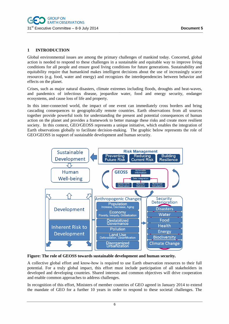
society. In this context, GEO/GEOSS represents a unique initiative, which enables the integration of
Earth observations globally to facilitate decision-making. The graphic below represents the role of
GEO/GEOSS in support of sustainable development and human security.
Figure: The role of GEOSS towards sustainable development and human security.
A collective global effort and know-how is required to use Earth observation resources to their full
potential. For a truly global impact, this effort must include participation of all stakeholders in
developed and developing countries. Shared interests and common objectives will drive cooperation
and enable common approaches to address challenges.
In recognition of this effort, Ministers of member countries of GEO agreed in January 2014 to extend
the mandate of GEO for a further 10 years in order to respond to these societal challenges. The
31st Executive Committee – 8-9 July 2014 Document 5
7
Implementation Plan Working Group (IPWG) was formed to prepare an implementation plan building
on the accomplishments to-date and Ministerial outcomes. This interim report represents a first
deliverable from the IPWG to the GEO Executive Committee, and marks the end of the initial
reflective phase, or 'fresh perspectives' exercise. It represents a key milestone towards the
Implementation Plan, an initial outline of which will be presented to the GEO Plenary in Gabon in
November 2014. This outline of the IP will include, in particular, issues and various scenarios upon
which the IPWG would welcome guidance from the Plenary.
The „fresh perspectives‟ phase was a window of opportunity to bring nominated experts together, to
gather exchanges and individual thoughts and to build the group into a collaborative structure. The
work was framed by the considerable foundations provided by GEO Vision 2025 and Plenary /
Ministerial documents from late 2013 / early 2014. The group has revisited these documents and tested
key statements through dialogue and questioning, as well as through consultation with the GEO
community to ascertain that we share a common understanding and identify where further
development or refinements are needed.
Whilst this report was requested by the Executive Committee, the IPWG sees the report as a means to
provide insight for the wider GEO community about IPWG reflections and as a mechanism to further
the pace of engagement across the community, participating organisations and member countries.
The decision from the Ministerial Summit in Geneva in January 2014 to renew the mandate of the
Group on Earth Observations (GEO) stems from the very definition, of GEO:
• Is a unique global initiative mandated to coordinate and facilitate the integration of,
and access to the data from atmosphere, land and ocean observing networks (both in situ and
remote sensing) and their associated information systems;
• occupies a key, strategic, upstream coordination position in the international
community with respect to observations, data and information about the Earth system in
support of other major initiatives; and
• brings together Governments and all relevant intergovernmental, international and
regional organizations, Non-Governmental Organizations (NGO) and the private sector, all
with an interest in Earth observations, under a flexible, voluntary framework for coordinating
strategies and investments, as well as developing new initiatives, through the on- going
implementation and use of the Global Earth Observation System of Systems (GEOSS) as the
main vehicle for cooperation.
As we develop the implementation plan through to 2025, GEO is being positioned to play a key role in
catalyzing this global action to help governments, institutions, and citizens around the world to make
informed decisions. Today‟s decisions require a vast amount of information from a large variety of
sources. Provision of information of different origin and type but in comparable and compatible forms
requires multi-stage and strong information management, which in turn requires a wide range of
expertise. Integrating physical data with social and economic information will enable rigorous
analysis and information analytics. Decision-makers and individuals need usable and actionable
information and knowledge on a temporal scale ranging from real-time to climate-scale, and on a
spatial scale ranging from local to global.
With the vast expertise and capabilities of its internal stakeholders ranging from data providers,
scientific bodies, technology companies, and information users, global cooperation through GEO will
afford global communities the means to accurate, quality, timely, useful information.
31st Executive Committee – 8-9 July 2014 Document 5
8
2 DRIVERS FOR CHANGE, CONSULTATION WITH STAKEHOLDERS, LESSONS
LEARNED AND STRENGTHS WEAKNESSES OPPORTUNITIES AND THREATS
This section outlines how the landscape has evolved during the first decade of GEO/GEOSS. Some
attention is given to external drivers as well as to how GEO/GEOSS itself has evolved. A summary of
key messages derived from consultation with stakeholders is also included. Together these elements
create the basis for an overview analysis of some strengths, weaknesses, opportunities and threats
(SWOT). This information is drawn together into several key lessons learned and forms the basis for
the action areas for GEO presented in section 3.
2.1 Input from the GEO community to the fresh perspectives phase of the GEO
Implementation plan
As a starting point, the IPWG took note of: “the 2014 GEO Ministerial Declaration” from the Geneva
Summit; the “Summary of the discussions from the Ministerial Session: Guidance for the Future of
GEO”, as prepared for the IPWG by the GEO Secretariat; and the recommendations set out in the
“Vision for GEO 2025”, which were adopted by the GEO-X Plenary. In accordance with its mandate,
during this initial phase the IPWG has also sought input from across the GEO Community, most
notably from existing GEO Working Groups and Implementation Boards, and those carrying out Work
Plan tasks through IPWG engagement at the GEO Work Plan Symposium. The IPWG also conducted
a survey within the GEO Community. The GEO Community Engagement Process during Phase 1 is
summarized in the Enclosure 1 to this Report. This section synthesizes the results of the consultation
with stakeholders to-date into brief statements as well as grouping some thoughts from the community
into fresh perspectives.
GEO‟s organizing principles and foundations are still valid.
The unique aspects of GEO should be kept: the System of Systems; a Community of Communities
approach, which provides a great deal of flexibility to work with different stakeholders from different
sectors, (GEO Members, POs, the private sector, etc.); and the agility and flexibility in the GEO
structure which enables key challenges to be addressed quickly. However, it is also important for GEO
not to repeat any mistakes made during the period 2005-2014 and to carefully apply the lessons learnt.
New technologies
GEO has a key role to play and should strengthen its efforts to ensure that relevant new technologies
can be easily implemented and then evaluated over time.
GEO has been very successful in those collaborative efforts where its role in relation to other
organisations has been clearly defined and accepted by all.
Noteworthy examples include, e.g., GEOGLAM, GFOI, CEOS, etc. However, perceptions of GEO's
role vary widely and this lack of clarity has been a barrier to GEO achieving its full potential. GEO
should therefore clearly articulate its unique role and mission, especially with respect to other
international organisations.
Contradictions between broad statements in strategic documents and the actual delivered
enhancements.
The future Strategic Targets need to be specific, measurable and achievable under the scope of GEO's
activities, reflecting the potential and constraints of the Implementation Plan period and GEO's
commitment mechanisms.
A concise and clear understanding of the targeted GEOSS users is essential.
To date, many GEO participants acknowledge that the first 10-year period has largely been driven by a
data-provider perspective and that GEO action has mainly focused on access to data and information
that exists. To really be user-driven, GEO should therefore have a more ambitious objective and also
31st Executive Committee – 8-9 July 2014 Document 5
9
look at what is needed, understand what is missing and act to make it available. The next years should
focus more on users, rather than on development: delivery to end-users should be a priority.
Systematic user engagement
Progress has been made to identify and engage users in many specific areas, but these efforts have not
yet become systematic. For example, all five M&E evaluations have pointed to gaps in user
engagement and have themselves had difficulty in obtaining user input to the evaluation process. GEO
should therefore target key categories of users, particularly those who require Earth observations and
information for the production of end-user products and services and who need information from
multiple domains or disciplines. Better use should also be made of Communities of Practice, seeing
one of their functionalities as that of users with links to scientific communities in particular.
GEOSS Common Infrastructure (GCI)
The need for implementing a more robust GCI and its operations varies depending on the users.
Sustainable funding arrangements to both develop and operate GCI beyond 2015 are needed in order
to meet user expectations
GEO/GEOSS relevance is key to GEOSS sustainability.
There is a need to convert environmental information into relevant and sought-after economic and
social information.
The modelling effort and connection to modelling communities needs to be enhanced
Although model products are present in GEOSS, they don‟t currently stand out and they don‟t have a
champion. GEO should be very clear that modelling is an integral part of GEOSS. This effort may be
enhanced by the use of a Model Web.
GEO needs more resources and stronger commitments.
Many statements state that there is dysfunctional management at task level, with a lack of resources
permeating every aspect of implementation.
Work Plan Task commitment is both uneven and inconsistent.
GEO has shifted over time from what might be termed a more “bottom-up” process, whereby any and
all contributions were accepted into the Work Plan, to a more “top-down” process in which there is a
conscious intent to manage the Tasks so as to maximise progress towards the Strategic Targets. To
increase GEO's ability to achieve its objectives and alleviate some of the burden and inefficiencies
associated with reporting and management, one step may be to have categories of contributions to the
Work Plan, where “core” activities are subject to greater reporting requirements and greater
management attention, while “non-core” contributions may still be accepted, but without triggering the
same degree of effort in tracking.
There is a lack of in-situ observation network coordination.
GEO should define actions to help in-situ communities to act in a more coordinated fashion. For
example, virtual in-situ constellations could be created, (similar to that of the global seismology
network). GEO should also consider establishing in-situ network forums to define appropriate
“global” networks and to incentivise countries to develop, share data and sustain operations of the
agreed national complements.
Fresh Perspectives from the Community
A key deliverable of the IPWG during this first phase was to seek out „fresh perspectives‟ for the next
GEOSS Implementation Plan. Stakeholders delivered some new ideas that the IPWG will reflect upon
during the second phase of its work. Namely stakeholders indicated that:
31st Executive Committee – 8-9 July 2014 Document 5
10
GEO should consider making Essential Variables a core concept for the next IP,
(whilst recognizing that it can take a long time to agree on Essential Variables);
GEO should develop and initiate „coordinating talks‟ with other organisations about
their needs, what we can provide, thereby enabling GEO to contribute towards their goals.
GEO should act strategically when reaching out to other organisations, looking to build
“strategic working” partnerships;
GEO should consider developing a "Community of Communities" framework for
the implementation of GEOSS Post-2015. This would: build on existing capacities,
enhancing communities, whilst respecting their mandates and not supplanting them; offer
a high level of flexibility; be open to new innovations as technology evolves; provide the
capability for interoperability between communities and sources of cultural, social and
economic information, which will play a critical role in decision making;
GEO should seek to become the point of reference for Earth observations and
information in the area of the Sustainable Development Goals (SDGs). Given the need
for both monitoring and “understanding” in support of the SDGs, GEO should align its
agenda with that of the SDGs;
GEO should support timely and knowledge-based decision-making in both public
and private spheres for improving the quality of life of people around the world and
advancing global sustainability;
GEO should take account of the changing “data landscape”, with Governments now
often passing responsibility for data collection to the private sector and to social
media. This leads to a more complicated “data landscape”, with the private sector moving
beyond a simple “data provider / value-added service / end-user” categorisation, to one in
which data providers within the private sector are also investing in data processing
services to better serve users by quickly moving to product generation;
GEO should look to “add value” for the private sector by: increasing the Earth
observation market (e.g. facilitating business development); facilitating the dialogue
between policy and decision makers and service providers; sharing the responsibility and
costs for innovation and capacity building; etc.;
GEO should recognise that the “service provider” constituency of the Private Sector
will want to use the GEOSS data infrastructure. GEO will therefore need to identify
and support those functionalities that are required to support application development.
GEO should also engage with the Private Sector to ensure that the Private Sector will
contribute towards the costs of upgrading the infrastructure to serve the private sector‟s
needs.
2.2 Drivers for change: A scan of key external trends affecting GEO in the last ten years
Much has changed in the world since the intergovernmental Group on Earth Observations developed
the first GEO Implementation Plan. Technology and science has progressed significantly, there has
been an increasing realization of the scale of environmental changes affecting the planet, the political
and policy context has shifted and the social and economic changes affecting the world have been
global in scale and impact.
In order for the second GEO Implementation Plan to address the challenges and opportunities offered
by these global changes, first they must be acknowledged and understood. This chapter aims to
highlight some of the key changes in the last ten years, which have impacted the implementation of
GEOSS and should therefore inform the approach and scope of the 2016 - 2025 Implementation Plan.
This list is not exhaustive, but highlights some of the most important trends.
31st Executive Committee – 8-9 July 2014 Document 5
11
2.2.1 Advances in Science and Technology
Internet, applications, and smart phones
The rapid growth of Internet content, applications and the explosion of smart phone use is driving new
ways to consume, create and manipulate information.
Rising expectations of being connected anywhere and anytime
There is a growing trend in both consumers and workplaces to expect global connectivity, and access
to communication and information outside of our offices/homes.
Google granting public access to, and increasing expectation of, geographic information
The advent of Google Maps and Google Earth in the early days of GEO transformed user expectations
and led to a growing familiarity with geospatial information and earth observations.
Spatial location services/GPS in everything/improvements in spatial accuracy
The development of smaller and more accurate GPS sensors during the last ten years has allowed
highly accurate geospatial location to be built into handheld devices and mobile phones, enabling a
range of location aware services.
Information and Communication Technology (ICT) advancements
Increasingly, advances in ICT are transforming our ability to make use of Earth observations. A
mobile phone today contains more computing power and storage than an average desktop computer
during the time development of the first GEO implementation plan. There has been an increasing trend
to using modular software systems and increasing use and sophistication in the development and
standardization of open source software tools.
Crowdsourcing and sensors in mobile phones (for both data acquisition and dissemination)
The power of harnessing “the crowd” in large-scale analysis of data has been demonstrated a number
of times over the last ten years. Crowdsourcing was used after the Haiti earthquake to rapidly map the
street network and inform emergency and recovery services of the status of buildings impacted. The
increasing inclusion of sensitive sensors in mobile phones and also machines, along with accurate
location awareness raises the tantalizing potential of crowd sourcing acquisition and calibration.
New space/satellite missions
Advances in the development of satellite observation platforms continues apace, with the development
and continuation of key operational earth observation platforms with open data policies such as
Landsat and the European Sentinel satellite series becoming increasingly useful in providing a long
term record of change.
Physical/Geophysical data and advances in monitoring technology
Our ability to gain insights about the depths of the oceans and the subsurface of our planet has
developed significantly over the last ten years using new geophysical approaches to data acquisition.
As well as development of new geophysical methods, the ongoing process of miniaturization and mass
production of useful sensors has led a revolution in the capability of sensing devices.
Airborne missions (including UAVs)
There is currently rapid global development of airborne earth observation systems, driven largely by
the relatively affordable deployment of Unmanned Aerial Vehicle (UAV) technology.
31st Executive Committee – 8-9 July 2014 Document 5
12
Citizens‟ Observatories
A rapidly developing and important change is the emerging importance of Citizens‟ Observatories.
Citizens‟ Observatories are based upon the development of community-based environmental
monitoring and information systems using innovative and novel Earth observation applications.
Advances in High Performance Computing and High Performance Data/Big data
The advent of increasingly powerful supercomputing facilities combined with organization of Earth
observation data at the same location as the computational power has the potential to revolutionize
Earth observation data handling.
Modelling advances (including integration and interpretation)
Advances in computing power now enable more complex, interdependent models that more
adequately represent the physical systems. The combination of empirical, deterministic and Bayesian
approaches to modeling and the application of these to modeling of complex interrelated earth systems
and processes is progressing apace, but the reliability of model predictions is an area of increased
scientific scrutiny.
Data quality, uncertainty and traceability
Some of the key emerging issues for the use of Earth observations to support decision making are the
issues of data quality, reliability, uncertainty and information provenance (traceability). Decisions are
increasingly being made on the basis of Earth observation information that may derive from a mix of
source sensors, organisations and countries. Understanding the quality of this information and its
“fitness for use” is increasingly critical information for the user to understand.
2.2.2 Environmental Change
Ten years is a short period in which to observe and measure environmental change. Many of the
environmental change drivers listed here are the same as they were when the first GEO
Implementation Plan was developed. If anything has changed, it is perhaps our understanding of these
changes and the urgency of our need to address them. Having the capability to measure, understand
and act on these global changes was one of the key reasons for the formation of GEO and the
development of GEOSS.
Climate change international consensus: IPCC sets out challenges ahead
The last ten years has seen the issue of anthropogenic climate change become a major focus of world
governments. IPCC predictions for climate change over the last ten years have reflected broad
scientific consensus and there has been a convergence among climate scientists globally about the
scale of the changes we will see, and a recognition that we have already started to see some of the
impacts of this change. Increasing challenges with weather and natural systems are one aspect with
frequency and/or severity of natural phenomena such as earthquakes, floods, droughts, cyclones,
storms, fires and heat waves are predicted in many areas of the world.
Impacts on the natural and human environments; Impact on food security
Climate change and human development has increased stresses on our environment over the past
decade. A trend of increasing urbanization and a move from subsistence agriculture to modern farming
methods has driven a rise in agricultural productivity across many areas of the world. The pace of
these adjustments has slowed however as we have begun to hit the natural limits of our environment
and constraints such as nutrient, soil and water availability will impact global food security in the very
near future.
31st Executive Committee – 8-9 July 2014 Document 5
13
Focus on adaptation
The global scientific consensus is that human induced climate change is now inevitable, while limiting
the extent and severity of the change is the subject of significant international negotiations and
activity. The predicted increase in extreme events (droughts, floods, cyclones, fires, earthquakes) will
require the earth observation community to develop tools and services which support the global
population to adapt, prepare and mitigate the risks of these changes.
Water, water quality and availability
Water stress and scarcity are affecting and will continue to affect the stability of communities in the
next decade, leading to many more countries experiencing water stress (This is caused by a
combination of changes water availability due to environmental factors and population related trends
in these countries).
Ocean acidification
As carbon dioxide levels rise in the atmosphere, the oceans buffering effect is leading to a change in
the carbonate/bicarbonate balance and the world‟s oceans are becoming more acidic. The impacts of
this to coral reefs, ocean productivity and biodiversity are only now being understood and the
importance of international cooperation to understand, observe, model and manage these impacts has
never been greater.
Land use change, deforestation, forest degradation
The impact of land use change and deforestation on greenhouse gas accounting has become much
clearer over the past decade. Reducing deforestation and forest degradation has become a key focus of
action by countries to mitigate the extent of anthropogenic climate change.
2.2.3 Political, Social and Economic Changes
Increasing globalization and international cooperation
The past ten years have seen some real successes in international cooperation in the Earth observation
and information domains. At the same time, continued globalization of the economy is a major “driver
for change”. Globalized production and trade increase the need for global monitoring of these
activities to improve the evidence base for resource management and related decision-making (e.g.
agriculture, forestry, fisheries, energy).
Vulnerability to global environmental change
Society is becoming increasingly vulnerable to severe extreme weather, climate and water events.
Vulnerability is driven by both risk and exposure, and is not solely driven by changes to weather or
natural risk, but also due to population and societal changes.
New business models and economic valuation paradigms
New business models continue to emerge for information and services, driven by innovation in
technology and sophistication in computer power and accessibility. The recognition of the value
provided by ecosystem services themselves has increasingly been recognized in economic terms. The
implications of this shift for ensuring we have the Earth observation information to measure and track
these services will have big implications over the next 10 years.
Changing concepts of community
Our traditional concept of communities has been largely geographically driven, driven by the primacy
of nation states and the concept that we have more in common with the people that live in our
proximity than those living far away. The increase in global connectivity and improvements in
communication, the rise of social media and the ability to associate with likeminded people
31st Executive Committee – 8-9 July 2014 Document 5
14
geographically distant is changing our concept of communities. A set of GEO/GEOSS communities
have emerged in the first decade of GEO and thus the design of the second implementation plan will
be different, seeking to actively engage the community in the design phase as well as allowing for
adaptation to the changing concepts of community in the timeframe of the next ten year. These, and
other communities now exist in an increasingly non-geographic sense. The implication of this on
decision-making and global political evolution is still unclear.
Changing GEO/GEOSS stakeholder profiles
Similarly, the stakeholder base of GEO/GEOSS has grown and changed significantly in the last 10
years. There are now dozens of new players, including a rapidly growing private sector engaging with
GEO and the focus of activity within GEOSS has expanded much broader than satellite based
observation to recognize the critical role of in-situ, airborne, and modeling data in a global earth
observing system.
2.3 Internal factors - Common threads and lessons learnt
As the IPWG needs to be cognizant of the rapidly changing world and emerging expectations from
stakeholders to help shape the next Implementation Plan, it also needs to carefully review the lessons
learned from GEO‟s successes and challenges over the past decade. Some key trends outlining what
were the success or failure factors for GEO are outlined below. These reflect a combination of what
the IPWG heard from the GEO community, results from the GEO evaluations, as well as IPWG‟s own
SWOT analysis, which is found in Enclosure 2.
Individual commitment – A strong driver on which to build
The nature of GEO “voluntary commitment framework” has been interpreted differently in different
cases and is often not reliable enough to build on. Sometimes this is perceived as a lack of real
national engagement and has led to increased insecurity beyond the work area directly affected. There
needs to be a strengthening that “commitments” translate into real-world delivery even if made
voluntarily. Personal engagement in GEO is often a strong driver for individuals to maintain their
commitment; links between individual, regional and national objectives and commitments need to be
strengthened.
Global initiatives – A success model to follow
Global Initiatives (e.g. GFOI, GLAM, GEOBON,) targeted around a specific use case and global
policy issue are considered a success; there is wide-spread recognition that GEO has been good at
nurturing these. Common elements for success were identified, including: specific and committed
resources by few initially, engagement of principal players early on (including users) and a hand-over
plan to key external players/stakeholders. These initiatives articulated clearly the niche of GEO vis-à-
vis other international organizations in these processes and avoided perceived competition with
Participating Organizations. Based on these positive learnings, the global initiative approach needs to
be broadened so that the niche of GEO in relation to other global issues is clearly set out.
A need to better define and communicate GEO‟s own “brand”
As demonstrated in the previous paragraph, GEO was successful in carving its own niche through the
global initiatives. Similarly, the GEO “brand” has been effective in linking and consolidating existing
disparate activities into a “system of systems”. However, this process has at times created tensions
related to perceived “re-branding” by GEO (i.e. putting GEO stamp on others’ activities) without
perceived added value. The GEO “brand” needs to be more specifically associated with improvements
it brings, whether through resources, principles, guidance, coordination or cooperation. A more
proactive communication strategy is also needed to better communicate GEO‟s value-added.
31st Executive Committee – 8-9 July 2014 Document 5
15
Engagement of users still too often sporadic
The lack of systematic user engagement and ambiguity about who the targeted users are has been
noted as an ongoing limitation in evaluations.
Lack of prioritisation prevents effective implementation
While GEO has been successful in developing strategic roadmaps and other similar visionary
documents (e.g. on capacity building, science and technology, user engagement, data citation, data
quality, etc.), these have not always resulted in full implementation. Consequently, there is a need for
more effective linkages among decision-making, prioritisation and resourcing mechanisms. This will
lead to more effective and focused implementation and prevent dedicated individuals from being side-
tracked by competing priorities.
Resources are a constant challenge
The lack of sustained resourcing mechanisms and disparity to ambition level has been identified as a
recurrent limitation. Furthermore, the missing link to developing banks, science foundations, private
foundations, or other donors has further impeded GEO‟s ability to succeed in its endeavors, given
inability to leverage resources and capacity from these organizations. Going forward, it was
recognized that a stronger engagement with the private sector will need to be further explored, in order
to expand and diversify GEO‟s resource base.
Evaluating performance useful but somewhat cumbersome
During the course of the first 10 year plan, Strategic Targets were only created mid-way through and
there was no logic model or standard criteria for monitoring progress, effort and results. Later, when
Strategic Targets were created, these were subsequently strongly decreased in number. Currently,
there is some focus on reporting and evaluating progress, however this is rapidly becoming a burden
for contributors and links to improvement mechanisms are missing. A new structure needs to be put in
place that recognizes both (vertical) silos and cross cutting structures, links targets to delivery and
indictors, and is dimensioned to the resourcing. Reinforced good practice, guidance and minimal
standards are needed.
3 DESTINATION 2025: CONSIDERATIONS FOR THE FUTURE
The purpose of this section is to serve as a guiding principle for the development of the
Implementation Plan for the next ten years. Taking into account that there is consensus that GEO is
not changing its overarching goal or vision, this section sets out some objectives and then outlines
main areas of activity foreseen for the coming decade. During the first phase of its work, IPWG‟s
efforts focused on further defining and detailing the key objectives and key actions that will form the
content of GEO‟s portfolio in 2016-2025. During this first stage, IPWG had not begun to determine
the implementation structure for GEOSS implementation.
Parts of the text in this section are extracted from the GEO-X and Ministerial Summit documents, to
place the resulting IPWG analysis in context.
Vision
The current vision for GEOSS is as follows: The vision for GEOSS is to realize a future wherein
decisions and actions for the benefit of humankind are informed by coordinated, comprehensive and
sustained Earth observations and information.
GEO Purpose & Strategic Objectives
The purpose of GEO is to build upon GEO's substantial accomplishments to improve the quality,
range and availability of Earth observations and information for the purposes of:
31st Executive Committee – 8-9 July 2014 Document 5
16
Achieving national and international objectives for a resilient society, sustainable
economy and healthy environment worldwide;
Addressing global and regional challenges by deepening understanding of the Earth
system processes and improving the link between scientific understanding and
policymaking at these levels;
Sustainably growing economies, reducing redundancy and reducing costs to public sector
budgets through innovation and shared collaborations.
Considering the increasing demand for Earth observations required to address sustainable
development needs and future challenges, and inform decision-makers, GEO will focus on the
following Strategic Objectives through 2025:
Coordinating strategies for acquiring Earth observations, seeking active collaboration with
relevant existing and emerging global initiatives with complementary mandates to both
promote full and open access to Earth observation data, and strengthen Earth observing
networks, strategic planning and identification of the needs for applications and services1;
Facilitating enhanced access to: 1) national, regional and global Earth observation data
and information (including “big data”2) by implementing a robust and user friendly
GEOSS information system that links available systems, also taking advantage of
repositories of "big data"; and 2) tools to transform the data and information into useable
formats for resource management and decision-making;
Fostering global initiatives that address identified gaps in Earth observation information
including, where appropriate, facilitating the development of associated services and
arranging for their subsequent uptake by relevant entities.
To achieve these objectives, GEO will perform key actions in the following three areas – Policy,
Knowledge, and Information. IPWG has chosen this organizing structure for the action areas as it
closely follows the domains of the three Strategic Objectives.
In the POLICY action area, GEO will:
Promote collective action on the basis of shared interest through fostering a coherent
global observation-based understanding of key environmental challenges by stakeholders
at all levels of decision-making, from political leaders to citizens;
Demonstrate the value of Earth observations to diverse stakeholder groups, including the
private sector, foundations, UN organizations, and civil society, with a purpose to
cultivate demand for and foster the use of Earth observations;
Grow GEO‟s user base by initiating and developing relationships with communities of
downstream users of Earth observations and information by focusing on understanding
their needs, mission objectives, preferred methods to receive and use information and
determine how GEO can help them meet those needs and objectives.
1 Note: In the context of this paper, the term “service” is defined as the delivery of products based on Earth
observation data and information addressing user needs through the coordinated use of the infrastructure and
assets of the Members and Participation Organizations.
2 Note: in the context of this paper, the term “big data” is defined as becomes difficult to process them using on-
hand database management tools or traditional data processing applications. The collections of data sets so large
and complex that it challenges include capture, curation, storage, search, sharing, transfer, analysis and
visualization
31st Executive Committee – 8-9 July 2014 Document 5
17
Promote the adoption of free, full, open and timely data access as a societal benefit;
Foster and develop commitments to strengthen observation systems (space-based, airborne
and particularly in-situ) and networks of observation systems;
Develop common strategies to inform investment planning for observing systems to enable
gaps to be identified, create synergies and maximize benefits from these systems;
Promote “acting local – thinking global” mentality through strengthening regional and
national capabilities to implement and make use of GEOSS, especially but not exclusively in
developing countries, through activities such as the dissemination of best practices,
strengthening of regional user communities, the development of regional and national Earth
observation plans and focusing on the access to and use of observations to deliver practical
local outcomes.
In the KNOWLEDGE action area, GEO will:
Strengthen existing communities of practice and create new ones as needed, actively
promoting interoperability and connectivity between the existing and developing
Community portals;
Systematically identify, prioritise and mitigate gaps in knowledge in the information chain
between observations and decisions in the arena of global decision support;
Expand the content of GEOSS by systematically pursuing availability and access to the
totality of needed data and information to enable users to access a complete suite of
resources needed for a particular problem solving;
Systematically, co-define and document observation requirements, jointly with user
communities, and determine and prioritise gaps in the availability of observations, and
share this information as a GEOSS resource;
Document observation and related information requirements as a basis for coordinated
strategies and action;
Develop and implement GEOSS Data Management Principles to promote the adoption of
best practices of sound data management to improve aspects such as interoperability, data
quality documentation and traceability, long-term archiving and usability;
Share best practices for creating usable information by well-coordinated observations and
data management;
Define best practices for data management, including defining and implementing methods
to document observation quality and the traceability of sources and methods for data,
products and information, with the intent of providing GEOSS users with sufficient
information to judge fitness for use;
Progressively harmonize the attributes of GEOSS data, proceeding from a minimum
requirements of explicitly recorded data provenance, to inter-calibration of data collected
in slightly different ways to, where possible, standardization;
Include social and economic data into the scope of GEOSS;
Promote the principles underlying integration of different classes of data such as remote
sensing, airborne, in situ, and citizen observations in the GEOSS information system;
31st Executive Committee – 8-9 July 2014 Document 5
18
Enhance the integration of observation-based models within GEOSS in order to serve user
needs for spatial, temporal and variable coverage. Promote interlinkages among models in
different domains;
Enable development of citizen observatories as a means to strengthen observing systems,
as well as also facilitating the use of data at multiple scales.
In the INFORMATION action area, GEO will
Prototype selected services through global or regional initiatives;
Actively promote the development of Earth observation-based information services in
support of the global sustainable development agenda and evidence-based decision
making;
Accelerate and incubate the evolution of the GEOSS information delivery capability
through prototyping services on the basis of GEOSS Implementation Pilots and new user
requirements;
Serve as an “honest knowledge broker” for Earth observations and environmental
information;
Operate a GEO Portal that provides access to GEOSS data and information resources,
including GEO‟s “knowledge base”, a comprehensive collection of information on
available Earth observations and its use.
4 CONCLUSION: KEY TAKE AWAY MESSAGES FOR THE GEO EXECUTIVE
COMMITTEE
In conclusion, the IPWG would like to convey key take away messages to the GEO Executive
Committee. These points came up through discussions during the first phase within the IPWG and
through engagement with key stakeholders. These messages reflect the background presented in this
report, and will help shape the next Implementation Plan.
The key messages/considerations have been divided under three main categories:
1. Maintain and strengthen;
2. Opportunities for improvement;
3. Fresh perspectives.
This categorisation keeps focus on what has worked and needs to be continued whilst also
acknowledging the room for improvements that exist in response to drivers and lessons learned. It
should be noted that some potential solutions have been identified under the “Opportunities for
Improvement” section. These solutions and the considerations as a whole will require a fulsome
evaluation by the IPWG as we advance in phase 2.
4.1 Maintain and strengthen:
Inclusivity. GEO should continue to engage with a wide variety of organisations
(governments, non-governmental organisations, and private sector);
Networking. GEO should remain a meeting point for both political and technical
stakeholders. Political buy-in at the ministerial level provides legitimacy, while
discussion fora provide the opportunity for technical considerations and user needs;
31st Executive Committee – 8-9 July 2014 Document 5
19
Adaptability. GEO is an “agile organisation” that can quickly address change (e.g.
emerging issues and emerging technologies). Communities of Practice are one
component that allows GEO to react to these changes;
Interoperability. A focus on interoperability provides a basis for increased use of
Earth observations, information and data, and provides an avenue for synergies
within, and added-value to, the GEO community;
Data sharing and access. Clearly stated positions on data sharing and free, full, open
and timely access. This foundation needs to be strengthened through the development
of principles and application guidelines on data management, data quality and
traceability / provenance;
Framework for cooperation. The intergovernmental partnership that is GEO should
be strengthened by establishing “end-to-end” initiatives in support of sustainable
development and environmental stewardship;
Capacity building. This should now be viewed as a universal action, such that
capacity building will encompass all GEO Members and Participating Organizations
(i.e. not only developing countries);
User focus. GEO needs to establish an efficient mechanism for identifying, engaging
with and enabling delivery of Earth observation data and information to end users.
4.2 Opportunities for improvement:
Performance assessment. The current Monitoring and Evaluation process has
required substantial effort and does not lead to actionable recommendations at the
Task level.
Potential solution: Streamline Monitoring & Evaluation procedures,
acknowledging the different characteristics of activities and their levels of
maturity, while ensuring the connection to GEOSS implementation tasks and
clearer objectives at task level setting out what will be achieved.
GEOSS Information delivery. Expectations vary with respect to the breadth and
depth of GEO in connection with information delivery. Clarity is needed. Concern has
been expressed over the proliferation of small and uncoordinated tasks within the
GEO community, alongside which global initiatives have sprung up within GEO in
response to the need for coherent, targeted, end-to-end solutions for decision-making.
Potential solutions:
o Breadth: Special attention should be paid to prioritization, grouping of
initiatives, incubation and alignment of activities;
o Depth: GEO should continue incubating/prototyping required / requested
services based on globally and regionally coordinated framework.
31st Executive Committee – 8-9 July 2014 Document 5
20
Resources. The uncertainty around levels of available resources and the mismatch
between objectives and committed resources have hampered GEO implementation,
led to imbalances and reputational issues.
There is no easy solution. The IPWG will examine options in phase 2 for how to
establish a robust, steady resourcing mechanism within the voluntary framework
of GEO, matching priorities and scope of a task with the identified committed
resources.
Fostering buy-in at a national level. It is difficult for nations to recognize, reflect
and leverage the GEO initiative in their decision making process.
Potential solution: Support nations to reflect the GEO achievements into their
decision-making process to achieve stronger buy-in at national level.
Definition of GEOSS. Considering the need to supply reliable Earth observation data
and information to end users, a clear definition of GEOSS and its vision and purpose
are needed.
Geographic balance. More geographically-balanced contributions by all members,
particularly developing countries and regional initiatives must be achieved.
Potential solutions: Proactively assist GEO Members in establishing national and
regional GEOs. Further contributions can also be achieved through incentivizing
active participation through the promotion/illustration of the benefits of
intergovernmental and interagency collaboration within a voluntary framework.
Environmental costs. Quantification of costs through inaction or incorrect decisions
in the context of environmental challenges should be a priority focus for GEO.
Potential solutions: Emphasize decision support based on Earth observations and
information as essential for sound “evidence-based” decision-making. Establish a
generic “risk management” (health, environmental, disaster) approach to clearly
link decisions (at the user level) with actions (within GEO).
Inter-linkages. GEO should strengthen inter-linkages between SBAs through a
“Community of Communities” concept.
Partnership. GEO should evolve its forms of engagement with key partners and
stakeholders, based on jointly agreed objectives and roles.
4.3 Fresh perspectives:
(To note: Of the three categories outlined in this section, the “fresh perspectives” category is the one
that still requires the most attention from the IPWG; more efforts are needed to more effectively
incorporate what we heard from the stakeholders and the findings of the evaluations. Below is an
initial glimpse only of the IPWG’s thinking so far.)
Establish GEOSS as the Knowledge Broker for Earth observations and environmental
information;
31st Executive Committee – 8-9 July 2014 Document 5
21
Document and maintain observation and related information requirements for GEOSS
and identify, prioritise and work to fill current gaps;
Integrate economic and social data in GEOSS;
Explicitly enhance model integration into GEOSS by forming bi-directional
partnerships with the modeling communities within a broader framework of enabling
decision support;
Evolve GEOSS objectives to include economic benefits from the use of Earth
observations and information for decision-making in the private sector and among
individuals;
Leverage new technologies and emerging approaches (e.g. citizen observatories);
Provide users of GEOSS-served data with sufficient information to judge its fitness
for use;
Through members and participating organisations, explicitly develop more critical
elements of GEOSS to a more “operational status” (to ensure reliable and repeatable
information delivery);
Pursuit of “free” and timely access to earth observation data, in addition to the
customary “full and open”.
31st Executive Committee – 8-9 July 2014 Document 5
22
ENCLOSURE 1
IPWG INTERIM REPORT
SUMMARY OF GEO COMMUNITY ENGAGEMENT PROCESS
TABLE OF CONTENTS
1. Introduction and scope
2. Sources of information
3. Summaries of the Geneva GEO week meetings and events
4. GEO Work Plan Symposium discussions
5. Joint meeting of GEO Boards and Working Groups
6. GEO Community Survey
7. Involvement of GEO Implementation Boards and Working Groups
Annex 1 GEO Community Survey questionnaire
Table 1.1 and Table 1.2 Replies to Question 1 of the GEO Community Survey
31st Executive Committee – 8-9 July 2014 Document 5
23
1 INTRODUCTION AND SCOPE
The IPWG Terms of Reference instructed the IPWG to involve the GEO Community in the
development of the new Implementation Plan.
Starting from the results of the Geneva Summit and GEO-X Plenary and in order to incorporate to the
extent feasible the expectations of the GEO Community into its Phase 1 Interim Report, the IPWG has
immediately undertaken specific actions and has taken advantage of already scheduled GEO events to
maximize input gathering from the Community during Phase 1.
While the Section 2.1 of the Report provides an initial and general overview on how the Community
assesses the GEO accomplishments and what would be some preferred directions for the future, this
Enclosure summarizes how GEO Community inputs were gathered.
2 SOURCES OF INFORMATION
The main sources of information to understand the Expectations of the GEO Community can be
summarized as follows:
1. The summaries of the Geneva GEO week meetings and events, namely the GEO-X Plenary,
the High-Level Event on the Perspectives on the Value of Earth Observations and the GEO
Geneva Summit;
2. The discussions held at the GEO Work Plan Symposium (28-30 April), not only during a
dedicated session, “Looking into the future of GEO and GEOSS”, but also throughout all the
Symposium agenda on matters of relevance for the IPWG mandate;
3. The discussions held at the Joint meeting of GEO Boards and Working Groups on May 2,
especially those related to the role that these existing bodies could play in this transition to the
second GEO period and on preliminary recommendations to the IPWG;
4. The results of a GEO Community Survey, designed by the IPWG, launched on April 24 and
closed on May 8;
5. The replies of the GEO Implementation Boards and Working Groups to a letter sent by the
IPWG Facilitators on 13 May.
In addition to the above, the Secretariat has received, and immediately forwarded to the IPWG,
unsolicited inputs from CEOS, the Committee on Earth Observation Satellites and ESA, the European
Space Agency - two GEO Participating Organizations. Both letters were focused on the substantial
contribution of the Participating Organizations to GEO and GEOSS and on the need, from their
perspective, for a more substantial involvement in the GEO governance and strategic thinking.
The following sections provide additional details on these sources.
3 SUMMARIES OF THE GENEVA GEO WEEK MEETINGS AND EVENTS
Several documents were produced and distributed to the IPWG to summarize the discussion that took
place during the Geneva week.
Official documents, namely the GEO-X draft summary report (prepared by the Secretariat and
circulated to GEO Principals);
Working documents, which were prepared by the Secretariat, by consulting the written
statements received by Delegation and the video recording of the meetings, aiming at
31st Executive Committee – 8-9 July 2014 Document 5
24
providing to the IPWG a fair background of the discussions and the statements on the future of
GEO. They are:
A Compilation of the GEO-X and Summit statements, made with the objective of
identifying GEO Successes and GEO Value added across a number of different areas;
The Summary of the Session 4 – Guidance for the Future of GEO of the Geneva
Summit;
Inputs from the GEO-X discussions, which provides the details of the discussion at
the Plenary on items related to the IPWG mandate;
A Compilation of Ministerial statements looking forward and providing hints on what
different members and POs think on GEO directions and priorities for the next
decade;
The report on the GEO week, including a summary of the High level panel.
4 GEO WORK PLAN SYMPOSIUM DISCUSSIONS
In addition to the usual summary of the overall WP Symposium proceedings, a specific summary was
developed focused on the discussions and conclusions of relevance for IPWG from various sessions
and a specific summary of Session 6 – Looking into the future of GEO and GEOSS.
5 JOINT MEETING OF GEO BOARDS AND WORKING GROUPS
A significant portion of the joint meeting was devoted to the discussion on GEO‟s past, present and
future and a number of conclusions and recommendations of relevance/interest for the IPWG emerged.
The summary of the joint meeting was provided to IPWG for consideration.
6 GEO COMMUNITY SURVEY
The IPWG developed a questionnaire for a survey targeting the GEO Community which was launched
on 24 April and concluded on May 8. (Questionnaire attached as Annex 1).
6.1 Survey questions
The survey was organized around the following six questions, the first one structured in predefined
answers to be rated, the other five offering room for individual answers.
1. How do you rate the importance of the following GEO objectives and to what extent has GEO
achieved them?
2. Which do you think should be GEOs 5 primary strategic objectives and/or functions for the
next 10 years?
3. Where has GEO been successful? What has enabled GEO to achieve this?
4. Where has GEO failed to achieve its objectives? Why? What would need to be changed to
overcome the past difficulties?
5. Where do you see the greatest need for improvement?
6. What should be maintained?
31st Executive Committee – 8-9 July 2014 Document 5
25
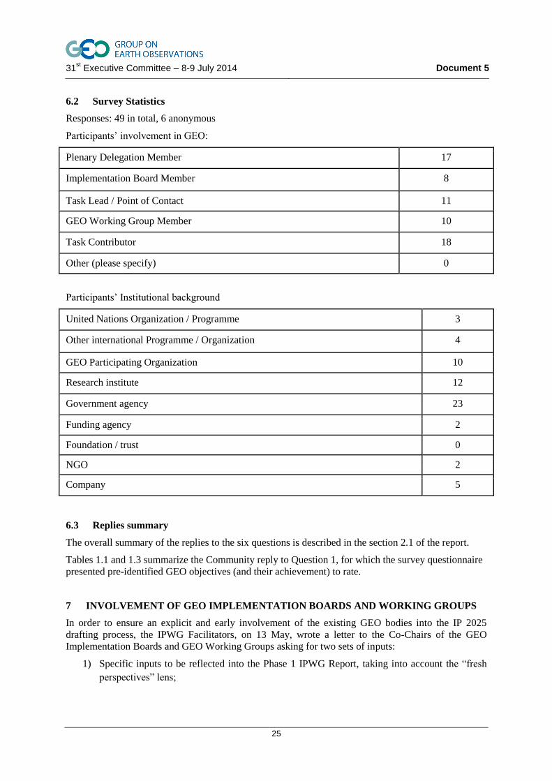
6.2 Survey Statistics
Responses: 49 in total, 6 anonymous
Participants‟ involvement in GEO:
Plenary Delegation Member 17
Implementation Board Member 8
Task Lead / Point of Contact 11
GEO Working Group Member 10
Task Contributor 18
Other (please specify) 0
Participants‟ Institutional background
United Nations Organization / Programme 3
Other international Programme / Organization 4
GEO Participating Organization 10
Research institute 12
Government agency 23
Funding agency 2
Foundation / trust 0
NGO 2
Company 5
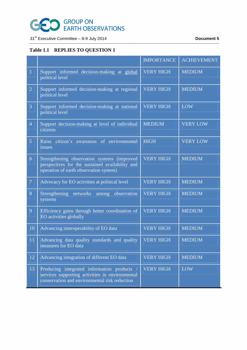
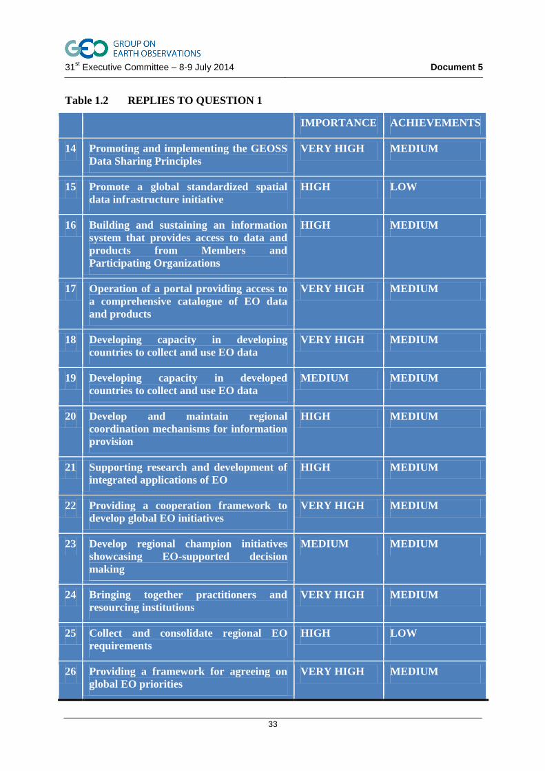
6.3 Replies summary
The overall summary of the replies to the six questions is described in the section 2.1 of the report.
Tables 1.1 and 1.3 summarize the Community reply to Question 1, for which the survey questionnaire
presented pre-identified GEO objectives (and their achievement) to rate.
7 INVOLVEMENT OF GEO IMPLEMENTATION BOARDS AND WORKING GROUPS
In order to ensure an explicit and early involvement of the existing GEO bodies into the IP 2025
drafting process, the IPWG Facilitators, on 13 May, wrote a letter to the Co-Chairs of the GEO
Implementation Boards and GEO Working Groups asking for two sets of inputs:
1) Specific inputs to be reflected into the Phase 1 IPWG Report, taking into account the “fresh
perspectives” lens;
31st Executive Committee – 8-9 July 2014 Document 5
26
2) A list and description of the on-going activities, led by each Board/Working Group that
address issues of relevance to the IPWG mandate, together with their proposals on how these
could be coordinated with the IPWG activities in Phase 2.
Specific responses were received from the Infrastructure Implementation Board, the Monitoring and
Evaluation Working Group and the Data Sharing Working Group. The other two Boards didn‟t
provide a specific answer but pointed the IPWG to the summary of the joint meeting of the 2 May,
referred above.
It is fair to state that all these inputs were widely reflected in the IPWG Interim Report.
31st Executive Committee – 8-9 July 2014 Document 5
27
ANNEX 1
SURVEY FORM
REQUEST FOR INPUT TO THE IMPLEMENTATION PLAN WORKING GROUP (IPWG)
The Implementation Plan Working Group was established by GEO-X and tasked to develop a draft
GEO Implementation Plan by GEO-XI (November 2014). To accomplish this objective, the IPWG
seeks to engage with the broad stakeholder community that will be important for the success of GEO
over the coming 10 years.
The current “GEO community” has gained experience on GEOSS implementation since 2005. Their
perspectives are a valuable asset in learning from the past to help chart the course for the future.
In this spirit, the IPWG invites your answers to the six questions below. If you wish to support the
IPWG by sharing your thoughts and insights, please submit your contribution to the GEO Secretariat
[email protected] and to Giovanni Rum ([email protected]).
SECTION I: VISION
7.1 QUESTION 1:
7.2 HOW DO YOU RATE THE IMPORTANCE OF THE FOLLOWING GEO OBJECTIVES AND TO
WHAT EXTENT HAS GEO ACHIEVED THEM3?
Importance GEO has achieved
Low Medium High Low Medium High
1 Support informed decision-making at global political level
□ □ □ □ □ □
2 Support informed decision-making at regional political level
□ □ □ □ □ □
3 Support informed decision-making at national political level
□ □ □ □ □ □
4 Support decision-making at level of individual citizens
□ □ □ □ □ □
5 Raise citizen’s awareness of environmental issues □ □ □ □ □ □
6 Strengthening observation systems (improved perspectives for the sustained availability and operation of earth observation system)
□ □ □ □ □ □
7 Advocacy for EO activities at political level □ □ □ □ □ □
3 The objectives below include the “GEO Core Functions“ defined in the “Vision for GEO 2025” accepted at the
Geneva Ministerial, 2014.
31st Executive Committee – 8-9 July 2014 Document 5
28
8 Strengthening networks among observation systems
□ □ □ □ □ □
9 Efficiency gains through better coordination of EO activities globally
□ □ □ □ □ □
10 Advancing interoperability of EO data □ □ □ □ □ □
11 Advancing data quality standards and quality measures for EO data
□ □ □ □ □ □
12 Advancing integration of different EO data □ □ □ □ □ □
13 Producing integrated information products / services supporting activities in environmental conservation and environmental risk reduction
□ □ □ □ □ □
14 Promoting and implementing the GEOSS Data Sharing Principles
□ □ □ □ □ □
15 Promote a global standardized spatial data infrastructure initiative
□ □ □ □ □ □
16 Building and sustaining an information system that provides access to data and products from Members and Participating Organizations
□ □ □ □ □ □
17 Operation of a portal providing access to a comprehensive catalogue of EO data and products
□ □ □ □ □ □
18 Developing capacity in developing countries to collect and use EO data
□ □ □ □ □ □
19 Developing capacity in developed countries to collect and use EO data
□ □ □ □ □ □
20 Develop and maintain regional coordination mechanisms for information provision
□ □ □ □ □ □
21 Supporting research and development of integrated applications of EO
□ □ □ □ □ □
22 Providing a cooperation framework to develop global EO initiatives
□ □ □ □ □ □
23 Develop regional champion initiatives showcasing EO-supported decision making
□ □ □ □ □ □
24 Bringing together practitioners and resourcing institutions
□ □ □ □ □ □
25 Collect and consolidate regional EO requirements □ □ □ □ □ □
26 Providing a framework for agreeing on global EO priorities
□ □ □ □ □ □
Further objective □ □ □ □ □ □
Further objective □ □ □ □ □ □

31st Executive Committee – 8-9 July 2014 Document 5
29
7.3 QUESTION 2:
7.4 WHICH DO YOU THINK SHOULD BE GEOS 5 PRIMARY STRATEGIC OBJECTIVES AND/OR
FUNCTIONS FOR THE NEXT 10 YEARS?
1. _______________________________________________________________________
2. _______________________________________________________________________
3. _______________________________________________________________________
4. _______________________________________________________________________
5. _______________________________________________________________________
SECTION II: LESSONS LEARNED
7.5 QUESTION 3:
7.6 WHERE HAS GEO BEEN SUCCESSFUL? WHAT HAS ENABLED GEO TO ACHIEVE THIS?
__________________________________________________________________________________
__________________________________________________________________________________
__________________________________________________________________________________
__________________________________________________________________________________
__________________________________________________________________________________
__________________________________________________________________________________
__________________________________________________________________________________

31st Executive Committee – 8-9 July 2014 Document 5
30
7.7 QUESTION 4:
7.8 WHERE HAS GEO FAILED TO ACHIEVE ITS OBJECTIVES? WHY? WHAT WOULD NEED TO
BE CHANGED TO OVERCOME THE PAST DIFFICULTIES?
__________________________________________________________________________________
__________________________________________________________________________________
__________________________________________________________________________________
__________________________________________________________________________________
__________________________________________________________________________________
SECTION III: GEOS STRUCTURE, APPROACH AND WORKING ARRANGEMENTS
7.9 QUESTION 5:
7.10 WHERE DO YOU SEE THE GREATEST NEED FOR IMPROVEMENT? (UP TO 3)
1. _______________________________________________________________________
2. _______________________________________________________________________
3. _______________________________________________________________________
7.11 QUESTION 6:
7.12 WHAT SHOULD BE MAINTAINED?
__________________________________________________________________________________
__________________________________________________________________________________
__________________________________________________________________________________
_______________________________________________________________________
31st Executive Committee – 8-9 July 2014 Document 5
31
SECTION IV: ABOUT YOURSELF
To help the IPWG interpreting and understanding the views and expectations expressed, please
consider characterizing yourself (more than one may apply):
GEO Institutional Background
Plenary Delegation Member □ United Nations Organization / Programme □
Implementation Board Member □ Other international Programme / Organization □
Task Lead / Point of Contact □ GEO Participating Organization □
GEO Working Group Member □ Research institute □
Task Contributor □ Government agency □
Other (please specify) □ Funding agency □
Foundation / trust □
NGO □
Company □
(Optional)
Your name: __________________________________________________________
Institution: __________
31st Executive Committee – 8-9 July 2014 Document 5
Table 1.1 REPLIES TO QUESTION 1
IMPORTANCE ACHIEVEMENT
1 Support informed decision-making at global
political level
VERY HIGH MEDIUM
2 Support informed decision-making at regional
political level
VERY HIGH MEDIUM
3 Support informed decision-making at national
political level
VERY HIGH LOW
4 Support decision-making at level of individual
citizens
MEDIUM VERY LOW
5 Raise citizen‟s awareness of environmental
issues
HIGH VERY LOW
6 Strengthening observation systems (improved
perspectives for the sustained availability and
operation of earth observation system)
VERY HIGH MEDIUM
7 Advocacy for EO activities at political level VERY HIGH MEDIUM
8 Strengthening networks among observation
systems
VERY HIGH MEDIUM
9 Efficiency gains through better coordination of
EO activities globally
VERY HIGH MEDIUM
10 Advancing interoperability of EO data VERY HIGH MEDIUM
11 Advancing data quality standards and quality
measures for EO data
VERY HIGH MEDIUM
12 Advancing integration of different EO data VERY HIGH MEDIUM
13 Producing integrated information products /
services supporting activities in environmental
conservation and environmental risk reduction
VERY HIGH LOW
31st Executive Committee – 8-9 July 2014 Document 5
33
Table 1.2 REPLIES TO QUESTION 1
IMPORTANCE ACHIEVEMENTS
14 Promoting and implementing the GEOSS
Data Sharing Principles
VERY HIGH MEDIUM
15 Promote a global standardized spatial
data infrastructure initiative
HIGH LOW
16 Building and sustaining an information
system that provides access to data and
products from Members and
Participating Organizations
HIGH MEDIUM
17 Operation of a portal providing access to
a comprehensive catalogue of EO data
and products
VERY HIGH MEDIUM
18 Developing capacity in developing
countries to collect and use EO data
VERY HIGH MEDIUM
19 Developing capacity in developed
countries to collect and use EO data
MEDIUM MEDIUM
20 Develop and maintain regional
coordination mechanisms for information
provision
HIGH MEDIUM
21 Supporting research and development of
integrated applications of EO
HIGH MEDIUM
22 Providing a cooperation framework to
develop global EO initiatives
VERY HIGH MEDIUM
23 Develop regional champion initiatives
showcasing EO-supported decision
making
MEDIUM MEDIUM
24 Bringing together practitioners and
resourcing institutions
VERY HIGH MEDIUM
25 Collect and consolidate regional EO
requirements
HIGH LOW
26 Providing a framework for agreeing on
global EO priorities
VERY HIGH MEDIUM
31st Executive Committee – 8-9 July 2014 Document 5
34
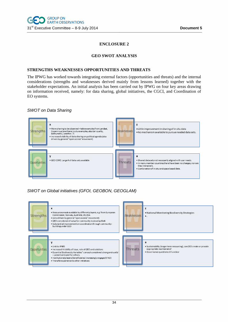
ENCLOSURE 2
GEO SWOT ANALYSIS
STRENGTHS WEAKNESSES OPPORTUNITIES AND THREATS
The IPWG has worked towards integrating external factors (opportunities and threats) and the internal
considerations (strengths and weaknesses derived mainly from lessons learned) together with the
stakeholder expectations. An initial analysis has been carried out by IPWG on four key areas drawing
on information received, namely: for data sharing, global initiatives, the CGCI, and Coordination of
EO systems.
SWOT on Data Sharing
SWOT on Global initiatives (GFOI, GEOBON, GEOGLAM)
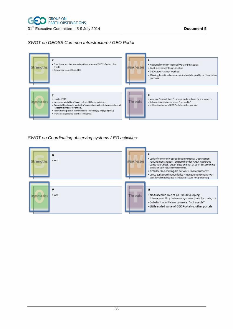
31st Executive Committee – 8-9 July 2014 Document 5
35
SWOT on GEOSS Common Infrastructure / GEO Portal
SWOT on Coordinating observing systems / EO activities: