Embed Size (px)
Citation preview

ISBN: 978-3-86395-138-2 Universitätsdrucke Göttingen Universitätsdrucke Göttingen
The Carbiocial Project investigates viable carbon-optimized land management strategies for maintai-ning tropical ecosystem services under land use change and changing climate conditions in Southern Amazonia – a hotspot of global change. The project aims at understanding the vital natural processes and socio-economic driving forces in the region and develops strategies to enhance and protect carbon stocks in the recently deforested agroscapes of Central/Northern Mato Grosso and South Pará. That is why Carbiocial analyzes and models soil, water and climate as well as agro-economics, social and poli-tical transformations. Based on detailed storylines, the project aims at identifying possible entry-points for a necessary change in local and regional production patterns, considering local livelihoods as well as the present national and global economic, legal and political situation. This book gives an overview of the fi rst results of the multi-disciplinary Carbiocial Project by publishing the main presentations, held on the Carbiocial Status Conference, on October 7-8, 2013, in Cuiabá. In sixteen chapters the authors elucidate the project‘s current state of knowledge, illustrating adapted methods for regional modeling and promising strategies for the Amazon development.
Gero
ld e
t al.
(Eds
.) In
terd
isci
plin
ary
Anal
ysis
and
Mod
elin
g of
Car
bon-
Opt
imiz
ed
Land
Man
agem
ent S
trat
egie
s fo
r Sou
ther
n Am
azon
ia
Interdisciplinary Analysis and Modeling of Carbon-Optimized Land Management Strategies for Southern AmazoniaG. Gerold, H. F. Jungkunst, K. M. Wantzen, R. Schönenberg, R. S. S. Amorim, E. G. Couto, B. Madari, S. Hohnwald (Eds.)
Carbiocial Status Conference in Cuiabá, October 7-8, 2013


Gerhard Gerold et al. (Eds.)
Interdisciplinary Analysis and Modeling of Carbon-Optimized Land Management Strategies for Southern Amazonia
This work is licensed under a Creative Commons Attribution-ShareAlike 4.0 International License.

erschienen in der Reihe der Universitätsdrucke im Universitätsverlag Göttingen 2014

G. Gerold, H. F. Jungkunst, K. M. Wantzen, R. Schönenberg, R. S. S. Amorim, E. G. Couto, B. Madari, S. Hohnwald (Eds.)
Interdisciplinary Analysis and Modeling of Carbon-Optimized Land Management Strategies for Southern Amazonia
Carbiocial Status Conference in Cuiabá, October 7-8, 2013
Universitätsverlag Göttingen 2014

Bibliographische Information der Deutschen Nationalbibliothek
Die Deutsche Nationalbibliothek verzeichnet diese Publikation in der Deutschen Nationalbibliographie; detaillierte bibliographische Daten sind im Internet über <http://dnb.ddb.de> abrufbar.
Address of the Editor Prof. Dr. Gerhard Gerold Geographical Institut Department of Landscape Ecology Georg-August-Universität Göttingen Goldschmidtstr. 5 37077 Göttingen Germany Tel.: +49 (0) 551 39 8012 Fax: +49 (0) 551 39 12139 [email protected] http://www.uni-goettingen.de/de/211024.html http://www.carbiocial.de/ This work is protected by German Intellectual Property Right Law. It is also available as an Open Access version through the publisher’s homepage and the Göttingen University Catalogue (GUK) (http://www.sub.uni-goettingen.de). The conditions of the license terms of the online version apply. Satz und Layout: Dr. Stefan Hohnwald Cover: Jutta Pabst Cover Picture: Dr. Stefan Hohnwald © 2014 Universitätsverlag Göttingen http://univerlag.uni-goettingen.de ISBN: 978-3-86395-138-2

1
Contents
p. 4 Preface p. 5 Acknowledgements p. 7-18 Stefan Hohnwald & Gerhard Gerold Carbon-Optimized Land Management Research for the Southern Amazon- Geographical and Organizational Settings of the Carbiocial-Carbioma Project Consortium p. 19-28 Philip M. Fearnside, Aurora M. Yanai & Claudia S. M. N. Vitel Modeling Baselines for REDD Projects in Amazonia: Is the Carbon Real? p. 29-39 Jens Boy, Charlotte Schumann, Simone Strey, Robert Strey, Georg Guggenberger & Regine Schönenberg Digging Deeper – Biographic Interviews as a Promising Tool for the Joint Dissemination of Natural- and Social Science Results in REDD Contexts p. 41-59 Carlos E. P. Cerri, Thalita F. Abbruzzini, Carolina B. Brandani, Mariana R. Durigan & Denise Signor Soil Carbon Stocks and Greenhouse Gas Emissions from Agrosystems in Brazil p. 61-69 Karl M. Wantzen, Malte Unger, Eduardo G. Couto, Ricardo S. S. Amorim, Karina P. Peña & Ulrich Irmler Carbon Farming: Enriching Tropical Farm Soils with Organic Matter
p. 71-83 Alphonce C. Guzha, Ricardo S. S. Amorim, Rodolfo Nóbrega, Gabriele Lamparter, Kristof Kovacs, Norma Bertão & Gerhard Gerold Impacts of Land Cover and Climate Change on Hydrology and

2
Hydrochemistry in Selected Catchments in Southern Amazonia: Preliminary Analysis and Results
p. 85-100 Marcus Schindewolf, Daniela Schönke, Ricardo S. S. Amorim & Jürgen Schmidt Effects of Contour Banks and No-Till Measures on Run-Off and Sediment Yield in Campo Verde Region, Mato Grosso p. 101-107 Alessandra R. Gomes, César G. Diniz & Cláudio A. Almeida Amazon Regional Center (INPE/CRA) Actions for Brazilian Amazon Forest: TerraClass and Capacity Building Projects p. 109-118 Patrick Hostert, Tobia Lakes, Hannes Müller, Florian Gollnow & Letícia B. V. Hissa Land-Use Monitoring and Change Detection p. 119-128 Jürgen Böhner, Helge Dietrich, Klaus Fraedrich, Tobias Kawohl, Markus Kilian, Valerio Lucarini & Frank Lunkeit Development and Implementation of a Hierarchical Model Chain for Modelling Regional Climate Variability and Climate Change Over Southern Amazonia p. 129-136 Claas Nendel, Hermann Jungkunst & Adriano M. R. Figueiredo Intercol and Steps Towards a Simplified DSS p. 137-148 Neli A. de Mello-Théry & Paulo R. Cunha Environmental Policies and Forest Code: Changes and Repercussions on the Agriculture in Mato Grosso p. 149-156 Regine Schönenberg, Korbinian Hartberger & Charlotte Schumann Challenges and Chances of Social Transformation for GHG-Optimized Land- and Natural Resource Management Strategies: Stakeholder-Dialogues as Prerequisite for the Elaboration of Applicable Results
3
p. 157-164 José H. Benatti & Luly R. da Cunha Fischer Land Use Regulations in the State of Pará: An Introductory Approach of Its Guidelines p. 165-168 Martin Coy, Michael Klingler, Matthias Siebold & Thomas Berger Socio-Economic Regional Change and Agro-Economic Development Along the BR-163 p. 169-170 Edna Castro Deforestation Along the BR-163: Socio-Environmental Conflicts and Ignored Governmental Politics p. 171-174 List of authors
4
Preface The Carbiocial project is investigating viable carbon-optimized land management strategies for maintaining tropical ecosystem services under land use change and changing climate conditions in the Southern Amazon – a hotspot of global change. The project aims at understanding the vital natural processes and socio-economic driving forces in the region and develops strategies to enhance and protect carbon stocks in the recently deforested agro-landscapes of Central/Northern Mato Grosso and South Pará. That is why Carbiocial is analysing and modeling soil, water and climate as well as agro-economics, social and political transformations. On the grounds of detailed storylines, we are identifying possible entry-points for a necessary change in local and regional production patterns, considering local livelihoods as well as the present national and global economic, legal and political situation. This book gives an overview on the first results of the multi-disciplinary project Carbiocial by publishing the main presentations, held on the Carbiocial Status Conference, on October, 7-8, 2013, in Cuiabá. Carbiocial and Carbioma members as well as Brazilian researcher from international well known research centres (INPA, INPE, USP, NAEA) present sixteen contributions to elucidate the actual state of knowledge of the project, adapted methods for regional modeling and promising strategies for the Amazon development.
Göttingen, June 2014 Gerhard Gerold

5
Acknowledgements The German project Carbiocial is funded by the German Federal Ministry of Education and Research (BMBF, FKZ: 01LL0902E), the Brazilian Carbioma project by National Council for Scientific and Technological Development (CNPq). The authors would like to thank these research sponsors, in particular our counterparts in Brazil. Special thanks also go to our external Brazilian authors, Dr. Fearnside, Prof. Dr. Cerri, Dr. Gomes, Prof. Dr. Mello-Théry, Prof. Dr. Benatti, and Prof. Dr. Castro and their research teams for providing full contributions for this book. Of course, we are most grateful to all involved farmers on whose farms we were allowed to conduct our field work. Last but not least, many thanks also go to Mrs. Sarina Meister and Mr. Karl Heyer for assisting the editing of this book. Editors: Prof. Dr. Gerhard Gerold – Göttingen, Germany Prof. Dr. Hermann F. Jungkunst – Landau, Germany Prof. Dr. K. Matthias Wantzen – Tours, France Dr. Regine Schönenberg – Berlin, Germany Prof. Dr. Ricardo S. S. Amorim – Cuiabá, Brazil Prof. Dr. Eduardo G. Couto – Cuiabá, Brazil Dr. Beata Madari – Goiânia, Brazil Dr. Stefan Hohnwald – Göttingen, Germany

7
Carbon-Optimized Land Management Research for the Southern Amazon – Geographical and Organizational
Settings of the Carbiocial-Carbioma Project Consortium
Stefan Hohnwald & Gerhard Gerold
Department of Landscape Ecology, Institute of Geography, Georg-August University, Göttingen
Summary The Carbiocial-Carbioma project consortium jointly investigates viable carbon-optimized land management strategies in Southern Amazonia – a hotspot of global climate change research. It tries to understand all main parameters towards improvement of the carbon stocks in the two concerned biomes of Central-West Brazil (rainforest, cerrado), e.g. by improving land use management. Consisting of twelve German and Austrian subprojects, the multi-disciplinary project is thereby organised in two main modules, namely in the Carbon Credit module “CAC” and the Land Use Management module “LUM”, plus the integrative communication module “Intercol”. Thereby, subprojects work on soil, water, climate, agro-economics as well as on society and politics to identify possible entry-points for a necessary change in local and regional production patterns, considering local livelihoods as well as national and global economic and political embeddedness. The main study regions are next to the cities of Novo Progresso (Pará), Sinop (Northern Mato Grosso) and Campo Verde (Central Mato Grosso), reflecting a climatological as well as land use gradient along the recently asphalted highway Cuiabá-Santarém BR-163. Carbiocial is trying to deliver a decision support tool based on original data and modelling that help to integrate improved carbon storage, social wellbeing and ecological requirements into a sound management of the agro-landscapes in the Southern Amazon.
Key words: BR-163, project structure, modeling, Brazil, project aims
8
1. Introduction The bilateral German-Brazilian project consortium Carbiocial-Carbioma, investigates viable carbon-optimized land management strategies in Southern Amazonia – a hotspot of global climate change research. It tries to understand the parameters responsible for enhancement of carbon (C) stock enrichment in tropical ecosystems, by for instance, improving land use management strategies. The Amazon is thereby one of the most important regions for the globally linked land surface–climate system. Research here cannot be done by a simple top-down approach and by breaking down global models and social perspectives. Therefore, to understand possible negative feedback between land use and climate change, region–specific analyses and models including on-farm experiments and stakeholder analyses are the primary goals of these projects.
The globally significant land use frontier of Southern Amazonia is highly dynamic (Coy 2005, Nepstad et al. 2002) and Mato Grosso experienced an increase of 87% in cropland and 40% of deforestation from 2001-2004. This development is accelerating along the Cuiabá-Santarém (BR-163) highway, nearly asphalted nowadays, and is associated with further major C losses and greenhouse gas (GHG) releases. Global interest in curtailing these emissions is high, as the relevance of the affected ecosystems (rainforest and savannas) for C storage and GHG cycling is of global importance. However, model calculations of C and GHG fluxes from the respective ecosystems for different land use scenarios are still highly uncertain because land cover patterns are not fully captured yet and GHG models need precise in-situ calibration. Consequently, regionally specified models are essential and are the key target of the Carbiocial-Carbioma consortium. In the Southern Amazon, climate change will probably increase unpredictability of rainfall, rising temperatures and extend drought periods. Due to the recession of natural vegetation, rainforests and campos cerrados in Central Mato Grosso, the intensification of land use both increases release of GHG and reduces ecosystem services, biodiversity, and human livelihoods.
Carbiocial therefore aims at providing interdisciplinary solutions for these problems. The main goals are to develop GHG-emissions mitigation strategies and maintaining ecosystem services under changing climate conditions. They are utterly needed to meet the goals set by Brazilian national plans and international treaties.
9
The joint main goals of the research cluster therefore are to
perform region-specific analyses in order to improve and apply interdisciplinary sets of models of land use impacts on C stocks, water and GHG balances,
develop and optimize land management strategies that minimize carbon losses and GHG emission and maximize carbon sequestration,
develop land use management decision support tools which integrate improvement of C-sink and GHG mitigation functions in the frame of “Climate Change” and agro-economic farm decisions
assess the trade-offs between land management options and socio-economic impacts in terms of GHG reduction, profitability and ecological sustainability,
support the Brazilian partners to implement the optimized techniques in practice, considering the soy bean value chain and overall carbon balance,
present a set of tools to communicate scientific knowledge and main results of the project to the stakeholders.
2. Methods Thereby, consistent with the project-structure, Carbiocial works on soil, water, climate, agro-economics, society and politics to identify possible entry-points for a necessary change in local and regional production patterns considering local livelihoods as well as national and global economic and political embeddedness (Kyoto-process, WTO-membership etc.). The following twelve subprojects (SP) aim at providing multi- and interdisciplinary solutions for these problems in strong collaboration with the main Brazilian partners of the Embrapa Rice & Beans (Goiânia), Federal University of Mato Grosso in Cuiabá and Sinop (UFMT), and the Federal University of Pará (UFPA-NAEA):
SP01 – Soil Degradation and Catchment Hydrology (University of Göttingen) SP02 – Greenhouse Gas Modelling & Measurement (University of Koblenz-Landau, BGR Hanover) SP03 – Erosion Modeling (University of Freiberg) SP04 – Soil Organic Matter Stocks and Turnover (University of Hanover) SP06 – Experimental Farming and Decomposers (University of Kiel, University of Tours) SP08 – Socio-Economic Drivers (University of Innsbruck) SP09 – Geodata Management and Land Cover Change (Humboldt
10
University of Berlin) SP10 – Climate Modeling (University of Hamburg) SP11 – Land Use Modeling (University of Kassel) SP12 – Agro-Economic Modeling (University of Hohenheim) SP13 – Crop Modeling (ZALF, Müncheberg) SP14 – Social Transformation (Free University of Berlin)
SP05 and SP07 (biodiversity: zoology, botany) have been cut short in the initial phase of the project.
The twelve Carbiocial subprojects are organized and structured in three main modules, namely the Carbon Credit Decision Support System Module (CAC), the land use management module (LUM) and the Collaboration and Communication Module (Intercol), including a strong working group on social transformation (SP14+SP08). All three have integrative components and researchers from all subprojects are involved in each module. By creating reliable linkages between local and regional patterns along the Brazilian highway BR-163, Carbiocial aspires to eventually improve the data basis for future political decisions.
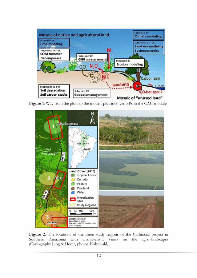
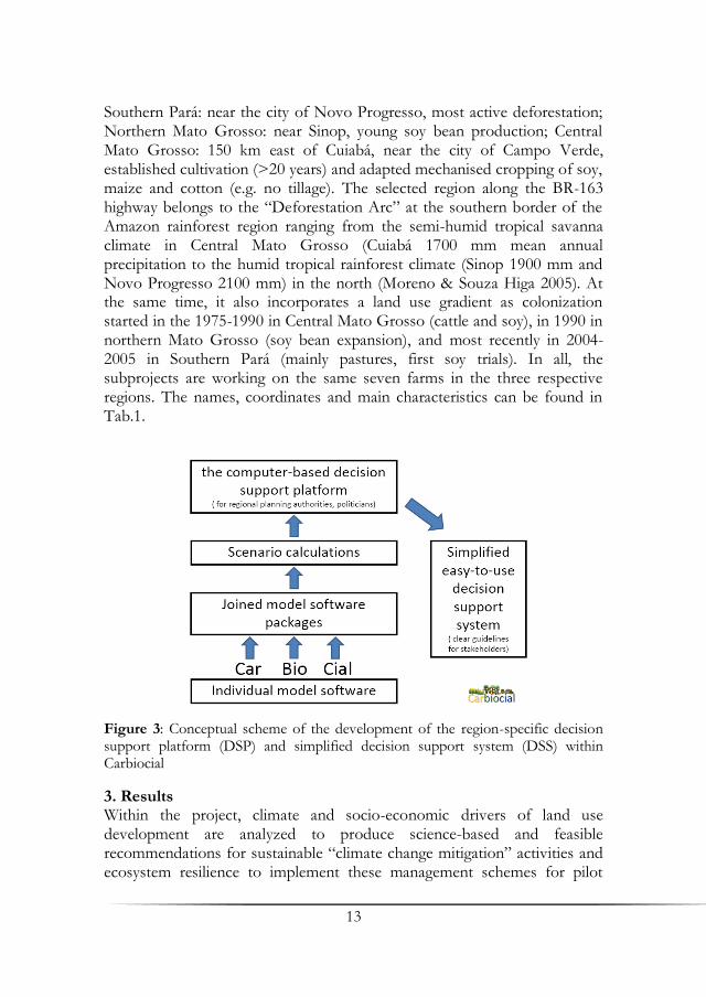
2.1 CAC – Carbon Credit Decision Support System Module The CAC-module (Carbon Credit Decision Support System Module) coordinates the work of all subprojects working at the plot scale, especially on the soil-water-atmosphere transition zones. In this way, CAC will bring together Carbiocial-Carbioma scientists and works to assess land use and land use change on a comprehensive way to integrate all get-at-able information on carbon stocks and greenhouse gas emission for the plot. Additional it will consider possible influences to adjacent plots, for instance due to erosion processes. The goal is to develop together with the Brazilian partners and local stakeholders a computer based decision support platform, which are adapted to the regional specification of Southern Amazonia. The way from the plot to the regional model and the included sub module are illustrated in Fig. 1. Additionally an easy to use tool is “extracted” from the model fusion which will be particularly useful for farmer organizations and local politics but also for state and federal governments and the scientific community as well. However, the latter will most likely be more interested in the joint models, which will be useful for more regional up to global politics as well. Both carbon credits tools will support the finding of optimized land use management options and regard to their individual potential impact of climate change.
11
2.2 LUM – The Land Use Management Decision Support Module This research cluster strives towards the development of a Land-Use Management decision support system (DSS) for the Southern Amazonia region. In a joint action of socio-economic, economic and biophysical modeller’s subprojects, two types of DSS for different groups of stakeholders are envisaged: a computer-based DSS for planners and decision-makers, including simulation models for own use and data tools to grasp recent climate trends, and a simple hand-held version for farmers. From the first stage of development stakeholders, such as farmer organizations, planning authorities and the agricultural research enterprise Embrapa, are involved and their feedback will significantly influence the result. Existing software packets serve as starting points to plug in new ideas. However, with the merging of agent-, rule- and process-based models onto a given platform being a major challenge in itself and with the reception of a computer-based platform by the stakeholders yet untested, the final product is still unknown. 2.3 INTERCOL- Collaboration and Communication Module With composition of the Intercol module, a close collaboration between the CAC and LUM and the social science group project is guaranteed. Also, the extensive expertise of the agricultural economic development in Mato Grosso as well as the co-project Carbioma is given. As the tasks of the Embrapa include the agricultural extension and dissemination of agricultural scientific knowledge to the farmers, an additional multiplier effect can be achieved for the discussion of future land use options, demonstration of the decision support platform, and the carbon enrichment techniques. The work of the forum is mainly targeted to co-ordinate the relations of the thematic working groups to each other and to make visible to the outside. In particular, the potential impact of socio-economic and climatic drivers on land use change (LUM) and the appropriate feedback mechanisms on the terrestrial carbon cycle (CAC), climate, agricultural production, social structure, market and policy issues in the region are the task of the Intercol
module. A strong socio-economic working group is especially formed by collaborating researchers of SP08, SP12 and SP14. Moreover, researchers of SP09 developed an open source geodata management (GDI) for intern Carbiocial-Carbioma data sharing. 2.4 Study Regions Three regions along the land use frontier of Southern Amazonia were selected for the projects (Fig. 2):
12
Figure 1: Way from the plots to the models plus involved SPs in the CAC-module
Figure 2: The locations of the three study regions of the Carbiocial project in Southern Amazonia with characteristic views on the agro-landscapes (Cartography Jung & Heyer, photos Hohnwald)
13
Southern Pará: near the city of Novo Progresso, most active deforestation; Northern Mato Grosso: near Sinop, young soy bean production; Central Mato Grosso: 150 km east of Cuiabá, near the city of Campo Verde, established cultivation (>20 years) and adapted mechanised cropping of soy, maize and cotton (e.g. no tillage). The selected region along the BR-163 highway belongs to the “Deforestation Arc” at the southern border of the Amazon rainforest region ranging from the semi-humid tropical savanna climate in Central Mato Grosso (Cuiabá 1700 mm mean annual precipitation to the humid tropical rainforest climate (Sinop 1900 mm and Novo Progresso 2100 mm) in the north (Moreno & Souza Higa 2005). At the same time, it also incorporates a land use gradient as colonization started in the 1975-1990 in Central Mato Grosso (cattle and soy), in 1990 in northern Mato Grosso (soy bean expansion), and most recently in 2004-2005 in Southern Pará (mainly pastures, first soy trials). In all, the subprojects are working on the same seven farms in the three respective regions. The names, coordinates and main characteristics can be found in Tab.1.
Figure 3: Conceptual scheme of the development of the region-specific decision support platform (DSP) and simplified decision support system (DSS) within Carbiocial
3. Results Within the project, climate and socio-economic drivers of land use development are analyzed to produce science-based and feasible recommendations for sustainable “climate change mitigation” activities and ecosystem resilience to implement these management schemes for pilot
14
regions. Existing computer-based decision support platforms are adapted to the region-specific conditions and calculate new results for three main future scenarios. A constant stakeholder feed-back process ensures the implementation of user requirements. Computer-based tools aim at the needs of policymakers and regional planning authorities. From these, simplified easy-to-use tools (basically print media) will be derived to illustrate the effect of climate change on biomass growth and yields and give guidelines for land and crop management options that are expected to mitigate GHG emissions while being profitable in terms of “carbon credits” for land management at the same time.
For the modelling of land use and the development of land use strategies a cluster of internationally recognized model tools will be assembled, building bridges with the approaches already in use in the Amazon. The model software developed by different groups of this project (ZALF, UFZ, CESR, University of Hohenheim) are either deterministic (agroecosystem models MONICA and DSSAT, integrated regional land-use change model LandSHIFT) or multi-agent-based (MP-MAS), and allow simultaneous simulation and assessment of economic feasibility of land use practices, yield risks, and income under the conditions of climate change and GHG reducing land use strategies (Wenkel et al. 2008, Kersebaum et al. 2008). So far, only hardly any software is available where the effects of Climate Change are sufficiently included in spatial long-term simulations. Another challenge that will be addressed here, is the simulation of socio-economic and environmental-political factors in land use decisions from a micro-economic perspective, as provided by the Multi-Agent-Modelling software MP-MAS (Berger et al. 2006). Complementary, the decision-making processes of the numerous relevant stakeholders will be analyzed within a broader picture of processes of social transformation in motion (Schönenberg 2002, Schönenberg & Castro 2004) with special emphasis on the effects of environmental jurisdiction and of future trends towards new lifestyles in urban centres and indigenous reserves. Qualitative and quantitative data will be systematized by MaxQDA and regarded in the final scenarios (best case, worst case). Simulation models will be combined into
software to support the decision-taking process based on field and acquired data, including a step-by-step up-scaling from local to landscape and regional scale (Fig. 3). All research and implementation activities include direct involvement of the stakeholder. Furthermore, joint field experiments and research for improving C-storage and ecosystem functions (e.g. water quality, soil erosion protection) are performed in tight cooperation with farmers and NGOs (e.g. farmer organisation of

15
Table 1: Farm positions, size, characteristics, and land use types used by Carbiocial
Region Farm Coordinates Characteristics Land use types
Novo Pro-gresso
Missassi 7.04501o S 55.3752o W
2247 ha, since 1979 2000 cattle
Old, new, and meliorated pastures, vereda, rainforest, hilly sites
Rubens 6.8585° S 55.5037° W
4500 ha, since 1990 pasture melioration in 2007
Old, new and mulched pastures, vereda, gallery forests, rainforest
Pará Florentina 7.1378° S 55.4066° W
3600 ha, since 1985 since 1980 pasture since 2002 rice
Rice, maize & soy fields, pastures, vereda, gallery forests, rainforest
Machado 7.1740° S 55.3964° W
260 ha, since 1985 400 cattle 2-3 years of rice
Old and new pastures, vereda, gallery forests, rainforest
Sinop Dona Isabina
12.0550° S 55.3516° W
1200 ha, since 1990 pasture since 2005 “plantio direto“
Soy, maize, mechanized pastures, vereda, gallery forests, rainforest
Santa Carmem
12.0550° S 55.3516° W
39000 ha, since 1985
Crops, pastures
North Mato Grosso
São Vicente
11.9313° S 54.9497° W
2000 ha, since 1995 pasture since 2005 “plantio direto“ no melioration
Soy, maize, old and new pastures, vereda, gallery forests, rainforest
Dona Dozolina
11.9932o S 55.1876o W
10000 ha, since 1990 “plantio direto“
Soy, maize, new pastures, vereda, gallery forests, rainforest
Campo Verde
Rio Engano
15.2424° S 54.5091° W
1500 ha, since 1984 since 1984 soy since 1996 “safrinha”
Soy, maize, old pasture, vereda, gallery forests, cerrado
Gianetta 15.8050° S 55.3373° W
since 2001
old pasture
Central Mato
Rancho do Sol
15.7953° S 55.3378° W
1150 ha, since 2001
cerrado
Grosso Santa Luzia
15.7381° S 55.3618° W
10000 ha, since 1980 since 2000 pasture
Soy, old pastures, cerrado, gallery forests
16
Mato Grosso- APROSOJA). A combined computer-based decision support platform will be
developed, including simulation models to run region specific impacts of different scenarios of land use options and climate change on GHG and C cycling. This will be a highly valuable tool for regional planning authorities. From the scenario calculations simplified versions (e.g. emission factors) will be made available as an easy-to-use decision support system for individual stakeholders. Results will be carried on by direct implementation of stakeholders, by human capacity building, and by promoting financially feasible, carbon-sequestering land use techniques throughout tropical areas with similar conditions.
4. Discussion Most recent simulations applying global climate models for Amazonian Forest (Malhi et al. 2008) predict 2.7 Mio. km² of deforestation until 2050. The main agro-economic driver will probably be soy bean expansion (Vera Diaz et al. 2009). For these land conversions of Amazonian Forests a release of 32 Pg C is predicted (Soares et al. 2006). Further land use change of roughly 50 Mio. ha is expected for the Brazilian savannas (Resck et al. 2000). Furthermore, the Cuiabá-Santarém highway (BR-163) grants less difficult access from already-established agriculture in the South to potential agricultural areas in the North. Consequently deforestation is additionally accelerated along this corridor. Putting these scenarios into the models, Carbiocial can contribute to demonstrate ecological and socio-economic consequences for the regional development.
Trade-offs between the potential to conserve or sequester carbon, stabilise crop yield variance, keep up societal values and protect ecosystem functions will be evaluated for alternative land management options under climate change conditions. On the farm level, impacts of GHG-reduced land management, of buffer zones and of forest recuperation and corridors between remnant vegetation patches will be measured in terms of ecological and economic outcomes. Additionally the effect of buffer zones on water and matter balances will be analysed at the landscape scale, as well as the competition between cash crop cultivation, pasture and bio-energy crops (model “LandSHIFT”).
Political and socio-economic driving factors of different options of agro-industrial reclamation of land will be analysed and included into the models. Gross margins for main production systems and farm enterprises as well as expected returns under climate change and GHG reducing land management strategies (carbon credits, impact of bio fuel development by soybean) will be analysed, modelled, and simulated. Agent-based simulation
17
at the fine scale will deliver plausible and realistic socio-economic assessments of C- and GHG-optimized versus conventional land use options. Agro-economic modelling will assess the trade-offs between various land uses and policy interventions in terms of GHG reduction, profitability (soy bean value chain) and ecological sustainability. Results from the final set of land use scenarios will be coupled with a decision support platform for land use options and delivered as a software package to the Brazilian stakeholders. Furthermore, a simplified easy-to-use version will be made available to individual farmers and other stakeholders. The Carbiocial project perfectly fits into the launched low carbon agriculture program of the Brazilian government, called “Programa ABC” (Agricultura de Baixo Carbono)- Low Carbon Agriculture (http://www.agricultura.gov.br/abc/). This underpins that Carbiocial is exactly in line with expectations of Brazilian politicians and the goals of Brazilian researchers. The Carbioma-co-project focuses on the main objectives of the ABC- and NAMAS-program (National Appropriate Mitigation Actions) with their research on the Embrapa experimental field stations.
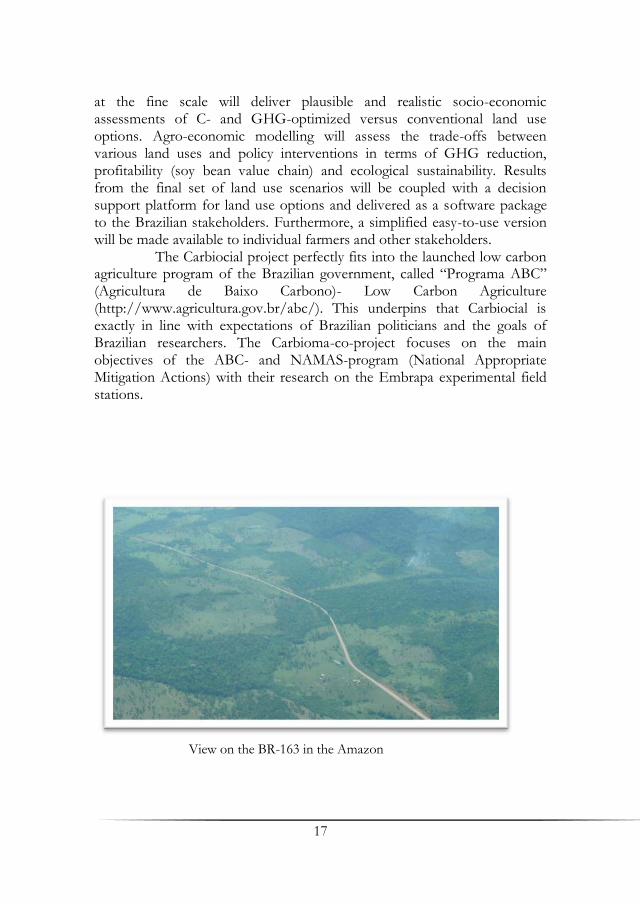
View on the BR-163 in the Amazon
18
References Berger, T., Schreinemachers, P., Woelcke, J. (2006): Multi-agent simulation for the
targeting of development in less-favored areas. Agricultural Systems vol. 88: 28-43.
Coy, M. (2005): Between Globalisation and Regionalisation: The Political Ecology of Pioneers Fronts in the South-West Amazon. In: Hall, A. (ed.): Global Impact, Local Action: New Environmental Policy in Latin America. London: 13-35.
Kersebaum, K. C., Wurbs, A., Jong, de R., Campbell, C. A., Yang, J., Zentner R. P. (2008): Long-term simulation of soil–crop interactions in semiarid southwestern Saskatchewan, Canada. European Journal of Agronomy vol. 29 (1): 1-12.
Malhi, Y., Timmons Roberts, J., Betts, R. A., Killeen, T. J., Li, W., Nobre, C. A. (2008): Climate Change, Deforestation and the Fate of the Amazon. Science vol. 319: 169-172.
Moreno, G., Souza Higa, T. C. (eds.) (2005): Geografia de Mato Grosso. Território, Sociedade, Ambiente. Entrelinhas, Cuiabá.
Nepstad, D., McGrath, D., Alencar, A., Barros, A.C., Carvalho, G., Santilli, M., del C. Vera Diaz, M. (2002): Frontier Governance in Amazonia. Science vol. 295: 629-631.
Resck, D. V. S., Vasconsellos, C. A., Vilela, L., Macedo, M. C. M. (2000): Impact of conversion of Brazilian Cerrados to cropland and pastureland on soil carbon pool and dynamics. p. 169–196. In Lal, R. et al. (ed.): Global climate change and tropical ecosystems. Adv. Soil Sci., CRC Press, Boca Raton.
Schönenberg, R. (2002): Die Kriminalisierung gesellschaftlicher Transformationsprozesse – Der Fall des brasilianischen Amazonasgebiets, HSFK-Report 9/2002.
Schönenberg, R., Castro, E. (2004): Formas e Causas da Criminalização da Transformação Social na Amazônia Brasileira, in: Sustentabilidade e Espaço Público na Amazônia Brasileira, Museu Paraense Emilio Goeldi (MPEG), Belém.
Soares-Filho B. S., Nepstad, D., Curran, L., Voll, E., Cerqueira, G., Garcia, R. A., Ramos, C. A., McDonald, A., Lefebvre, P., Schlesinger, P. (2006): Modelling conservation in the Amazon basin. Nature vol. 440: 520-523.
Vera Diaz, del M. C., Kaufmann, R. K., Nepstad, D. (2009): The Environmental Impacts of Soybean Expansion and Infrastructure Development in Brazil’s Amazon Basin. Tufts University – Global Development and Environment Institute. Working Paper No. 09-05.
Wenkel K. O., Wieland R., Mirschel W., Schultz A., Kampichler C., Kirilenko A., Voinov A. (2008): Regional Models of Intermediate Complexity (REMICs): a new direction in integrated landscape modelling. In: Environmental modelling, software and decision support: state of the art and new perspective. Elsevier, Amsterdam, 285-295.

19
Modeling Baselines for REDD Projects in Amazonia: Is the Carbon Real?
Philip M. Fearnside, Aurora M. Yanai & Claudia S. M. N. Vitel National Institute for Research in Amazonia (INPA), Manaus
Summary Reducing Emissions from Deforestation and Degradation (REDD) projects have an important potential role in mitigating global warming, but they are subject to the effects of regulatory loopholes and information gaps that can result in attributing undeserved climate benefits or carbon credit. Carbon emission reductions must be “real” in their effect on atmospheric CO2 concentrations, as distinct from being a mere accounting formality that may or may not conform to regulatory requirements. Problems in assuring that emission reductions are real also apply to many other forms of mitigation and are by no means limited to REDD. A key weak point is the baseline scenario, which is a hypothetical calculation of the land-use change and emissions that would occur without the mitigation project. Depending on circumstances, distortions can occur with either a historical baseline (based on continuation of past deforestation rates) or with a modeled baseline (based on simulation of future changes in land use). Modeling of Amazonian deforestation is improving such that modeling artifacts that have resulted in exaggerations in projected emissions are eliminated.
Key Words: Global warming, mitigation, deforestation, Brazil, climate change, environmental services 1. REDD and Climate Mitigation If mean global temperatures are to be kept within the bounds now agreed as defining “dangerous” climate change (2°C above pre-industrial temperatures), mitigation will require that large amounts of carbon emission are either avoided or absorbed within a short time frame. The emissions that must be mitigated include not only the “direct human-induced” emissions covered by the Kyoto Protocol, but all net emissions, including “indirect” and “natural” sources. Mitigating these will require greatly reducing emissions both from fossil-fuel combustion and from other sectors, including land use, land-use change and forestry (LULUCF). If global warming is to be contained, it is essential that the carbon emission
20
reductions be real – not mere paper accounting formalities that do not correspond to changes in carbon flows into and out of the atmosphere. The large amounts of money to be spent on mitigating global warming translate into intense pressure from companies and governments to influence the regulatory and accounting procedures in the most profitable ways possible from the point of view of the interested parties. The temptation is obviously great to create loopholes in the regulations in order to allow “non-additional” projects to receive financial benefits. "Non-additional” projects are those that would happen anyway without the additional subsidy from sale of carbon benefits. Non-additional projects are explicitly forbidden by the Kyoto Protocol (Article 12) in the case of the Clean Development Mechanism (CDM). However, the fact is that non-additional projects are commonplace in the CDM; a survey of 222 registered projects founded that 26% of the projects sampled have a contribution to their overall internal rate of return (IRR) lower than 2%, suggesting that these projects would be likely to occur anyway (Wen & Yong 2010). A clear example is provided by the many hydroelectric dams that are being built as a result of massive national programs that have little or nothing to do with combating global warming (e.g. Fearnside 2013a). Another example is credit for no-till planting of soybeans as a means of increasing soil carbon, since the shift from traditional plowing to no-till agriculture is occurring anyway simply because it is financially more attractive, even without carbon credit (Casão Junior et al. 2012). In projects of all types, wherever uncertainty allows a choice in constructing a baseline there is an inherent temptation for project developers to choose the scenarios that attribute the greatest carbon benefit to their proposed projects.
Mitigation projects are divided into two groups: voluntary and official. The “voluntary” market refers to carbon sales either directly from project developers to interested parties (such as companies wishing to market their products as “carbon neutral”), or to sales on a number of carbon exchanges around the world (such as the Chicago Climate Exchange, or CCX). “Official” markets include the Clean Development Mechanism and the European Union Emissions Trading Scheme (EU-ETS). A variety of national governments (such as the Netherlands) and sub-national governments (such as the US state of California) have carbon offset programs that pay projects for climatic benefits. An important difference between voluntary and official markets is the matter of scale: the massive reductions that must be achieved globally to contain climate change imply that large amounts of carbon and money will be exchanged on official markets, where countries are purchasing carbon in order to fulfill formal commitments under the United Nations Convention on Climate Change

21
(UNFCCC). By contrast, the voluntary market, which has until now been the only one purchasing carbon from Reducing Emissions from Deforestation and Degradation (REDD), is much more limited. This is because the voluntary market depends on the willingness of companies to pay to be able to claim corporate responsibility, which can be attained with efforts that are merely taken from the perspective of the amounts of global emission reduction needed to bring climate change under control. The different carbon markets have widely varying standards for certification and verification of the emissions reductions.
Another divide in mitigation proposals is between those based on a fund and those using a market mechanism. A fund would pay for emissions reductions at a fixed rate, whereas in a market the price is determined by the equilibrium between supply and demand, as in economic exchanges of all types. An important difference between the two is the price that can be obtained. A fund for paying for mitigation projects is proposed to make payments based on the opportunity cost of foregoing deforestation (e.g. Greenpeace 2008, p. 19). In the case of most of Brazilian Amazonia this means the low return that can be had by converting forest to cattle pastures that are both ephemeral and of poor quality, thereby giving up the root of the value of the carbon in competing directly with more expensive mitigation alternatives such as increasing the efficiency of vehicles and industries (e.g. Fearnside 2012a). The equilibrium between supply and demand can maintain high carbon prices in two ways. The first way is by restricting supply, which can be done either by either excluding different forms of mitigation from the market (as has occurred for REDD in the 2008-2012 First Commitment Period of the Kyoto Protocol) or by only allowing a small percentage of mitigation to use forest credits (as occurred for afforestation and reforestation projects in the CDM under the 2001 Marrakech Accords). The second way is by increasing demand, which in this case means convincing countries to agree to making larger cuts in their greenhouse gas emissions. It is the second approach that is needed if climate change is to be contained (Fearnside 2012b).
2. REDD Project Baseline Scenarios For calculating the carbon benefits of mitigation projects, the emission observed through monitoring as the project proceeds is compared with the emissions that would have occurred had there been no project. Estimating what “would have occurred” involves a counterfactual reference or “baseline” scenario. Because the baseline is necessarily a calculation, rather than a direct observation, it is inherently subject to “gaming” or manipulation such that the carbon benefits are exaggerated and the
22
mitigation project is more profitable. There are two types of baseline: historical and simulated. A historical baseline uses a deforestation rate as measured over a past period, and assumes that this will continue into the future, while a simulated baseline uses a model of future deforestation to represent what would happen without the project. The historical baseline has the advantage of being less subject to gaming, but it too can exaggerate deforestation in cases where clearing rates are declining (for example due to exhaustion of available forest, as is a factor in parts of Mato Grosso).
The challenge of ensuring that REDD project baselines are realistic is illustrated by the first project of this type in Amazonia: the Juma Sustainable Development Reserve (RDS Juma) in Brazil’s state of Amazonas. To calculate the deforestation that would occur without the project, the Project Design Document (PDD) (IDESAM 2009) used a map of the output from a regional simulation model (SIMAMAZONIA) representing deforestation in Amazonia through 2050 published in the highly respected journal Nature (Soares-Filho et al. 2006). While the simulation of deforestation may represent regional trends, it is subject to serious distortions when a “cookie-cutter” procedure is used to examine what will happen in a specific piece of the landscape, such as the Juma reserve. The SIMAMAZONIA model calculates deforestation in a series of sub-regions, but the one that includes the Juma reserve is enormous, covering the state of Amazonas and parts of Pará and Mato Grosso. The total amount of deforestation occurring each year was influenced by the forest area, which is tremendous in this sub-region. The location where this deforestation occurs is then determined based on probabilities that are dependent on the existence of previous deforestation and roads. Since these are concentrated in the corner of the sub-region that includes the Juma reserve, almost all of the deforestation in the sub-region is allocated to this corner of the sub-region. The baseline deforestation by 2050 in the Juma reserve used in the PDD based on the SIMAMAZONIA output is 4.3 times greater than that projected by a simulation that avoids this distortion (Yanai et al. 2012). The amount of deforestation avoided in the Juma reserve since the project began in 2008 is undoubtedly modest, as the project area is inhabited by traditional riverside residents who deforest very little anyway. Note that the REDD project excludes the portion of the Juma reserve where most deforestation is currently occurring, namely the area along the AM-174 road that bisects the reserve. The potential to have a greater carbon benefit lies in the grassroots support that the project benefits generate for creating other sustainable development reserves in the vast areas of forest that are still unprotected in the state of Amazonas. Unfortunately, this
23
potential has so far been squandered, as creation of new protected areas in the state has been virtually zero since 2008.
REDD in Amazonian indigenous areas is potentially very important because these areas contain 26% of the remaining forest carbon in Brazilian Amazonia (Moutinho et al. 2011, p. 108). Indigenous areas are not immune from deforestation, those in Mato Grosso providing a clear example (Fearnside 2005). The first REDD project in an indigenous area is the Suruí Forest Carbon Project in the Sete de Setembro Indigenous Land (Terra Indígena Sete de Setembro). This indigenous area, which straddles the border between the states of Rondônia and Mato Grosso, shows improvement in baseline modeling, but illustrates other problems inherent in mitigation projects in general – not only REDD projects. A preliminary baseline calculation used the SIMAMAZONIA output; for reasons similar to those in the Juma case, the SIMAMAZONIA projection indicated very rapid deforestation. SIMAMAZONIA indicated deforestation for the 2003-2008 period in the Suruí territory 64% higher than what was observed for the same period from satellite imagery (PRODES), leading the authors of the preliminary baseline to adjust the future projection downward by this percentage (IDESAM 2010, p. 26). This contrasts with the Juma project, where no such downward adjustment was applied. A more realistic baseline model (SIMSURUÍ) was used in the version of the PDD submitted to the Voluntary Carbon Standard (VCS) (IDESAM & Metareilá 2011) and in the version that was subsequently validated (IDESAM & Metareilá 2012).
In 2010 a severe drought affected the southwestern portion of Brazilian Amazonia (Lewis et al. 2011), and fire escaped from burning of pasture that had been (illegally) planted inside the reserve under a sharecropping arrangement with neighboring ranchers. An area of 4187 ha was burned (Graça et al. 2012). Forest fires favored by climate change underway in Amazonia represent a significant threat to carbon stocks expected to be maintained through future REDD projects in the region (Aragão & Shimabukuro 2010). The Suruí project proponents have initiated preparation of a request to revise the project baseline PDD to remove the carbon stock lost to the fire (Metareilá 2013). VCS regulations permit this for a “catastrophic reversal,” which can be either a natural event such as drought and fire or “man-made events over which the project proponents have no control such as acts of terrorism or war.” The Suruí case illustrates the inherent difficulty of dealing with such events in REDD projects. The 2010 drought was an event of a type that is expected to become much more frequent in the future as a consequence of global warming (Cox et al. 2008). The fire started from human action with the involvement of individual Suruí, although not the tribal leadership. The carbon project commits the
24
tribe to control deforestation (but not degradation) in all of the Sete de Setembro Indigenous Land. The tribal leadership does not have dictatorial powers over the behavior of individual Suruí. In practice, denying the group an economically viable alternative through REDD would lead to significant losses of forest in this indigenous area and, indirectly, in much wider areas in other indigenous areas. The revision baseline scenarios to remove unfavorable events is a pattern that is frequent in the in both the CDM and in the voluntary market, and is by no means restricted to REDD projects.
Indigenous REDD in Brazil has suffered a severe setback due the action of “carbon cowboys,” or proponents of carbon contracts with indigenous leaders that bypass both the existing carbon verification and certification systems and FUNAI (National Foundation for the Indian), which is the Brazilian government agency charged with indigenous affairs (Talento & Luchete 2013). A national scandal over contracts with these unscrupulous operators, particularly with the Muduruku tribe, has hindered progress in initiating indigenous REDD projects in Brazil, but in the case of the Suruí project, FUNAI was consulted and has not objected. The Suruí project is the center of attention due to the project’s strategic importance for REDD initiatives throughout the region. 3. National Baselines and Accounting A national baseline, rather than separate baselines for each individual project, has the advantage of avoiding much of the effect of “leakage,” or the reduction of the net benefit of a project because the emission (in this case from deforestation) that would have occurred in the project area is displaced to a location outside of the area (e.g. Fearnside 2009a). If a national baseline is used, then only the much smaller leakage to other countries would apply (Fearnside 1995). Brazil has proposed a baseline for the purpose of calculating national emissions reductions from reducing deforestation using a reference deforestation rate of 19,508 km2/year, which is the average historical rate for the 1996-2005 period (Brazil CIMC 2008). However, by the time this was announced annual deforestation had already decreased to about half this rate for reasons largely unrelated to mitigation (Fearnside 2009b). The decline in deforestation rate from 2004 to 2008 is explained by commodity prices, but the decline continued over the 2009-2013 period despite a recovery in these prices. After 2008 the decline is believed to be due to policies (Assunção et al. 2012). Particularly important is blocking of subsidized bank loans for properties that violate restrictions on deforestation. This is probably more important than inspections and fines for illegal clearing (fines are often never collected in practice due to legal difficulties).
25
REDD projects are inherently much more limited in their effect on deforestation than are changes in national policies, such as those affecting taxes, agricultural finance and subsidies, land tenure, settlement projects, enforcement programs, and the expansion of highways and other infrastructure. Policies at this level affect national deforestation totals (i.e., those reported in national inventories under the UNFCCC), but the results are hard to attribute to individual actions such as projects. The best solution is for countries such as Brazil to take on national quotas (assigned amounts) under the Kyoto Protocol or a subsequent agreement and sell carbon based on the national inventory, as through Article 17 of the Kyoto Protocol (e.g., Fearnside 1999, 2001). Although Brazil has now probably lost the opportunity to sell the carbon from most of the large decline in Amazonian deforestation rates since 2004, accepting a quota by joining Annex I of the UNFCCC and Annex B of the Kyoto Protocol remains an option that is very much in Brazil’s national interest (Fearnside 2013b). 4. Conclusions Is the carbon real? The answer is that often at least some of the carbon benefit claimed for REDD projects is not real. However, improvements in modeling deforestation are eliminating the repetition of past distortions. The needed role of REDD in overall efforts to contain global warming, together with the social and environmental co-benefits of using this mechanism to maintain Amazon forest, make further improvement a high priority. 5. Acknowledgments The author’s research is supported exclusively by academic sources: Conselho Nacional do Desenvolvimento Científico e Tecnológico (CNPq: Proc. 304020/2010-9; 573810/2008-7), Fundação de Amparo à Pesquisa do Estado do Amazonas (FAPEAM: Proc. 708565) and Instituto Nacional de Pesquisas da Amazônia (INPA: PRJ15.125).

26
References Aragão, L. E. O. C., Shimabukuro, Y. E. (2010): The incidence of fire in
Amazonian forests with implications for REDD. Science 328: 1275-1278. Assunção, J., Gandour, C. C., Rocha, R. (2012): Deforestation Slowdown in the
Legal Amazon: Prices or Policies? Climate Policy Initiative (CPI) Working Paper, Pontífica Universidade Católica (PUC), Rio de Janeiro. http://climatepolicyinitiative.org/publication/deforestation-slowdown-in-the-legal-amazon-prices-or-policie/
Brazil, CIMC (Comitê Interministerial sobre Mudança do Clima) (2008): Plano Nacional sobre Mudança do Clima – PNMC – Brasil. Ministério do Meio Ambiente (MMA), Brasília, DF. 129 pp. http://www.mma.gov.br/estruturas/imprensa/_arquivos/96_01122008060233.pdf
Casão Junior, R., de Araújo, A.G., Llanillo, R. F. (2012): Plantio Direto no Sul do Brasil: Fatores que Facilitaram a Evolução do Sistema e o Desenvolvimento da Mecanização. Instituto Agronômico do Paraná (IAPAR), Londrina.
Cox, P. M., Harris, P. P., Huntingford, C., Betts, R. A., Collins, M., Jones, C. D., Jupp, T. E., Marengo, J. A., Nobre, C. A. (2008): Increasing risk of Amazonian drought due to decreasing aerosol pollution. Nature 453: 212-215.
Fearnside, P. M. (1995): Global warming response options in Brazil's forest sector: Comparison of project-level costs and benefits. Biomass and Bioenergy 8(5): 309-322.
Fearnside, P. M. (1999): Como o efeito estufa pode render dinheiro para o Brasil. Ciência Hoje 26(155): 41-43.
Fearnside, P. M. (2001): The potential of Brazil's forest sector for mitigating global warming under the Kyoto Protocol. Mitigation and Adaptation Strategies for Global Change 6(3-4): 355-372.
Fearnside, P. M. (2005): Indigenous peoples as providers of environmental services in Amazonia: Warning signs from Mato Grosso. pp. 187-198. In: A. Hall (ed.) Global Impact, Local Action: New Environmental Policy in Latin America, University of London, School of Advanced Studies, Institute for the Study of the Americas, London.
Fearnside, P.. M. (2009a): Carbon benefits from Amazonian forest reserves: Leakage accounting and the value of time. Mitigation and Adaptation Strategies for Global Change 14(6): 557-567.
Fearnside, P. M. (2009b): Brazil’s evolving proposal to control deforestation: Amazon still at risk. Environmental Conservation 36(3): 176-179.
Fearnside, P. M. (2012a): The theoretical battlefield: Accounting for the climate benefits of maintaining Brazil’s Amazon forest. Carbon Management 3(2): 145-148.
Fearnside, P. M. (2012b): Brazil's Amazon Forest in mitigating global warming: Unresolved controversies. Climate Policy 12(1): 70-81.

27
Fearnside, P. M. (2013a): Carbon credit for hydroelectric dams as a source of greenhouse-gas emissions: The example of Brazil’s Teles Pires Dam. Mitigation and Adaptation Strategies for Global Change 18(5): 691-699.
Fearnside, P. M. (2013b): What is at stake for Brazilian Amazonia in the climate negotiations. Climatic Change 118(3): 509-519.
Graça, P. M. L. A., Vitel, C. S. M. N., Fearnside, P. M. (2012): Detecção de cicatrizes de incêndios florestais utilizando a técnica de análise por vetor de mudança na Terra Indígena Sete de Setembro – Rondonia. Ambiência 8: 511-521.
Greenpeace (2008): Forests for Climate: Developing a Hybrid Approach for REDD. Greenpeace International, Amsterdam. http://www.greenpeace.org/international/Global/international/planet-2/report/2008/12/ forestsforclimate2008.pdf
IDESAM (Instituto de Conservação e Desenvolvimento Sustentável do Amazonas) (2009): Projeto de redução de emissões de GEE provenientes do desmatamento na Reserva de Desenvolvimento Sustentável do Juma, Amazonas, Brasil. Documento de Concepção do Projeto (DCP), versão 5.1. IDESAM, Manaus. http://www.idesam.org.br/documentos/pdf/PDD_Projeto%20 Juma_portugues.pdf
IDESAM (Instituto de Conservação e Desenvolvimento Sustentável do Amazonas) (2010): Projeto de REDD Suruí: Aplicação dos Passos 2, 3, 4, 5, 6, 7 e 9 da Metodologia de Fronteira (VM0015). Versão 3.0. Fevereiro 2010. IDESAM, Manaus. http://idesam.org.br/wpcontent/uploads/2013/08/Relatorio-LB1-Surui.pdf
IDESAM (Instituto de Conservação e Desenvolvimento Sustentável do Amazonas), Metareilá (Associação Metareilá do Povo Indígena Suruí) (2011): Projeto de Carbono Florestal Suruí. Version 1.0. 13 de outubro de 2011. IDESAM, Manaus. http://www.idesam.org.br/publicacoes/pdf/PCFS_PDD_portugues_V1.pdf
IDESAM (Instituto de Conservação e Desenvolvimento Sustentável do Amazonas) & Metareilá (Associação Metareilá do Povo Indígena Suruí) (2012): Suruí Forest Carbon Project. Version 1.2. 14 February 2012. IDESAM, Manaus.
Lewis S. L., Brando, P. M., Phillips, O. L., Van der Heijden, G. M. F., Nepstad, D. (2011): The 2010 Amazon drought. Science 331: 554.
Metareilá (Associação Metareilá do Povo Indígena Suruí) (2013): Suruí Forest Carbon Project (PCFS): Technical note on the forest fire in the TISS in September and October 2010. Version 1.0, March 2013. Metareilá, Riozinho.
Moutinho, P., Stella, O., Lima, A., Christovam, M., Alencar, A., Castro, I., Nepstad, D. (2011): REDD in Brazil: A focus on the Amazon. Principles, criteria, and institutional structures for a national program for Reducing Emissions
28
from Deforestation and Forest Degradation - REDD. Center for Strategic Studies and Management, Brasília. http://www.cgee.org.br/publicacoes/redd.php
Soares-Filho, B. S., Nepstad, D. C., Curran, L. M., Cerqueira, G. C., Garcia, R. A., Ramos, C. A., Voll, E., McDonald, A., McDonald, P., Schlesinger, P. (2006): Modelling conservation in the Amazon Basin. Nature 440: 520-523
Talento, A., Luchete, F. (2013): Índios ‘alugam’ terras para exploração ilegal de madeira. Folha de São Paulo. 26 January 2013. http://www1.folha.uol.com.br/poder/1220815-indios-alugam-terras-para-exploracao-ilegal-de-madeira.shtml
Wen, H., Yong, A. (2010): Investment Additionality in the CDM. Ecometrica White Papers. 7 July 2010. http://ecometrica.com/white-papers/investment-additionality-in-the-cdm/
Yanai, A. M., Fearnside, P. M., Graça, P. M. L. A., Nogueira, E. M. (2012): Avoided Deforestation in Brazilian Amazonia: Simulating the effect of the Juma Sustainable Development Reserve. Forest Ecology and Management 282: 78-91.
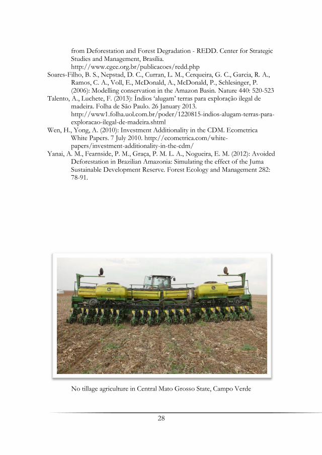
No tillage agriculture in Central Mato Grosso State, Campo Verde

29
Digging Deeper – Biographic Interviews as a Promising Tool for the Joint Dissemination of Natural and Social
Science Results in REDD Contexts
Jens Boy1, Charlotte Schumann2, Simone Strey1, Robert Strey1, Georg Guggenberger1 & Regine Schönenberg2
1 Institute of Soil Science, Leibniz University of Hanover 2 Institute for Latin American Studies, Free University of Berlin
Summary During interdisciplinary fieldwork of social- and natural scientists it became apparent that biographic interview-based storylines could act as suitable tools for disseminating the complex results of both disciplines jointly on stakeholders’ level. Here we discuss the possible implications of using these tools in the context of REDD schemes and describe the identified patterns and parallels between social and natural structures apt for dissemination purposes. Key words: Amazon, deep carbon, carbon politics, REDD, interdisciplinary research
1. Introduction Although we act on the assumption that social sciences and natural sciences only receive chances for mainstreaming their findings by practicable dissemination, one can observe that both disciplines fail to use understandable languages in their day-to-day science communication. Interdisciplinary research helps to overcome such problems jointly. Case studies where social and natural processes become manifest in jointly elaborated research questions and results are a good common ground for interdisciplinary research. While both sciences often fail to communicate case studies on the stakeholder level due to their specific languages, we started our case study discussing the best suitable plots for deep-carbon measurements with indigenous stakeholders by largely avoiding tech-talk. Social sciences had already generated a good platform for working procedures in the field by institutional mapping and biographic interviews

30
with the key players. Biographic interviews clearly show changes in structures, processes, and elucidate trends, and that’s exactly what natural scientists do with their environmental studies by undertaking “biographic interviews” of community changes, just asking the questions differently by chemical and environmental analytics. Interestingly, during this joint process it turned out, that natural scientists understand biographic interviews as such much better than sociological analysis thereafter, as social scientists have a far better understanding of forest ecology by joint field visits than by reading the respective strange papers. So it seemed rewarding putting some thoughts into the possibility of disseminating natural science results as biographies of plants, forests and soils, along with the respective insights of the social sciences.
A story-telling approach for dissemination of natural science results is especially rewarding when dealing with REDD or PES-schemes in the sense of voluntarily, market based instruments (Engel et al. 2008). Here, the natural science base is often not present at the stakeholder’s level, leading to unrealistic high (or even low) expectations on the value of the good or service in question (Baker et al. 2010). Carbon sequestration is a good example for the obstacles imposed by different scales in time or functional (natural) processes involved: In the event of paying for a certain carbon stock preserved by measures at the local stakeholder’s level, it has to be decided, how the avoided carbon release should be portioned over the runtime of the contract (Mahanty et al. 2013). A climax forest has comparably little increase in standing (=aboveground) biomass, since growth is basically replacing biomass loss of over-aged individuals, resulting in a regrowth-decomposition equilibrium. In simple words: If you don’t touch this forest, the CO2 emitted by the decay of dead plant material equals the CO2 extracted from the atmosphere by newly grown plants on the long run. The carbon stock represented by the standing biomass of the forest thus is relatively stable over time. But this is only half the truth: an often underestimated carbon pool is the soil C-pool, which can be larger than the standing biomass (Laurance et al. 1999). And here, old-growth forests represent one of the few consistently growing terrestrial C-sinks despite stable biomass C-stocks (Luyssaert et al. 2008), meaning that C stocks in soil under old growth forests sequester additional amounts of C over time while having the growth-related carbon pool already “capitalized” to the maximum possible extent. Additionally to soil processes conserving carbon much better under old-growth forests, the functional traits of climax species add to higher C investments and lower turn-over rates in soil, highlighting the misunderstanding that plantations with fast-growing trees could be treated equally to old-growth natural forests, if only the biomass is the same
31
(Shibistova et al. 2012). Thus, the first problem in REDD schemes is the measurement of
the C-stocks, especially regarding the soil C-pools to a sufficient depth, since much of the carbon is stored deeper than 1m, the usual maximum measuring depth (Nepstad et al. 1994; Jobbagy & Jackson 2000; Harper & Tibbett 2013). These C-stocks could be converted into money based on the rates of the CO2 emission market, leading to the second problem of how the resulting payments are stretched over the runtime of a REDD contract (Karsenty 2008). To simply divide the value of the stock by the years contracted, is neither a working economical decision nor a viable solution on human scale, since it ignores social processes at the locale. Additionally, the question “what comes next after the end of the contract” continues influencing the process of forest protection. While the standing biomass (not to be confused with the soil C pool) of old-growth forests can be hardly considered as a C sink when undisturbed but a tremendous C source when destroyed (Fearnside et al. 2009), the turn-over process of growth and decomposition is just one circle process among others, also involved into the C-sequestration game at the forest stand level. Parts of the dead plant material are worked into soil and stay there for different time spans. Time spans regulated by different triggers like chemical structure of the plant material, microclimatic conditions, soil parameters and soil depths, just to name a few. Thus, a bunch of various other C-“substocks” occur in soil and stay there for different periods due to their varying turn-over rates (e.g. Zech et al. 1997). This is best explained by an example: Let’s say there are 100 tons per hectare in the living biomass (including roots) and 100 tons in soil organic matter, a degradation of an old-growth climax forest to a secondary shrubland might mean that you end up with 50 tons per hectare after 20 years in the biomass but still 90 tons in soil. Simply calculating 60 tons C as emitted is true for the 20 years itself, but it might be that the 90 tons in soil will decrease to 30 tons over the next 50 years because of the far longer turn-over rate of the soil organic matter combined with the missing input and formation of new soil organic matter, due to the far lower production of fresh biomass of the degraded ecosystem. Thus, the conversion of the forest has an aftermath of another 60 tons of C emitted, which never appeared in the contract. From the stakeholders point of view, the avoided deforestation (= the management he is paid for) receives only half the money worth. On the other hand, soils under old-growth forests continuously increase the carbon storage as long as the stand is untouched, a circumstance under rather limited consideration in REDD schemes. Some of the obstacles in REDD schemes resulting from the complex ecological subtext are e.g. discussed in Stickler et al. (2009) or Ziegler et al. (2012).
32
Thus, anybody agreeing on REDD-contracts should have a basic understanding of ecosystem functioning and the different time scales any action to the ecosystem service imposes to the very same ecosystem service via the wide selection of natural feedback mechanisms.
Additional knowledge needed to create informed REDD contracts are the above mentioned political scopes of actions on national and international level, also in order not to create false expectations. After in 1992 the UN Climate Convention stated a clear need of joint action in the political sphere to reduce worldwide carbon emissions, an official market for trading carbon emission certificates was created in Kyoto. REDD is still not officially part of this but parallel negotiations on how to implement REDD and REDD+ are increasing. Especially - but not only - in Brazil, policy-makers and experts are debating whether to strengthen REDD as a market mechanism heavily based on offer and demand, or whether an idea of “justice” should come into play, where western industrialized countries pay into a fond that is being administrated by the governments of the countries that emit less carbon. This would give more control to the states in the question of repartition of benefits but weaken the direct involvement of the actors that actually reduce emissions. While there exists a quite long experience with payment for environmental services in Brazil, until today, there exists no legal regulation for REDD in Brazil on a national level. Some Brazilian states have shown own initiatives to create laws envisioning regulatory projects, but they could all be nullified by a federal law, yet to come. Still, there exist several law projects circulating in the Brazilian congress that show once more how complicated the question of “How to REDD?” actually is: Controversies include for example the question of whether incentives should focus on “traditional” forest inhabitants that mostly live without logging (“good guys approach”) or should focus on nowadays loggers in order to make conservation financially more attractive than cutting (“bad guys approach”). These discussions show how close ideas of social justice are linked to climate change prevention. The “Fundo Amazonia” is – among other things – a first attempt to finance and implement REDD projects in Brazil on the basis of fund-financing (Fatheuer 2010).
When talking about the benefits of “carbon conservation”, the financial possibilities and feasibility of such projects for local stakeholders is an important point of debate. In this special case, it was even more complicated: indigenous people and their rights in Brazil is a highly complex topic that we cannot deal with in this article. Just very broadly, it is very recent that these people are accepted judicially as legal autonomous and able to act as full citizens. There still exist laws that limit their possibilities of

33
participation in society, and the new role of the responsible state organ FUNAI (Fundação Nacional do Indio) after tutelage is still being debated. However, Brazil’s new constitution (1988) secured basic rights in the Magna Carta– especially indigenous peoples’ right to territory and cultural as well as social reproduction. Still, different from other countries in Latin America, Brazil’s indigenous people have the right to enjoyment of their inalienable territories and their resources (with limitations regarding subsoil resources), but the final ownership stays with the Brazilian state. Therefore controversies on if and how carbon certificates generated through emission reduction on these territories are of complete ownership and salable by indigenous people are not solved, although several judicial reports have been published on this topic (Yamada & do Valle 2009, Rojas Garzon 2009). Furthermore, several national and international legislations like the ILO Convention 169 and the UN Declaration of Indigenous Rights, but also the above mentioned new constitution, secure indigenous people a very strong right to self-determination and participation (Yamada & do Valle 2009). REDD emerged as a mechanism that did not include indigenous participation and proposals in its creation although it is likely to have high influence on their future lives. This initial exclusion has been criticized from various sides, especially NGOs and indigenous groups (Fatheuer 2010). All these principles, frameworks and controversies have to be taken into account when discussing REDD and carbon stocks with indigenous groups (see for a recommendation how to approach the topic: FUNAI 2010).
This takes us back to the story-telling approach. Feedback-mechanisms are hard to understand on the abstract level of science, but are very accessible in biographies, where decisions, often even taken by another generation, are leading to clearly deducible consequences in today’s life. The human interest in history and tales helps to bridge large time spans and, at least this is the hypothesis, could be used for dissemination of natural science results in order to make good advice accessible and digestable for local stakeholders in a process of personal-aphorism enriched natural self-consultancy. Thus, we intend to shed light on the construction of a common platform for inter- and transdisciplinary field research (Jahn et al. 2012) and subsequent subject related debates on the social and physical significance of deep carbon for the mitigation of GHG-emissions in the Amazon.
2. METHODS Basically, we each stuck to our research methods concerning the measurement of soil carbon, turnover, biomarkers and stable isotope approaches, respectively, the understanding of ongoing social
34
transformations. The natural scientists engaged themselves in the sampling of soils and the social scientists in stakeholder and institutional mapping, expert and biographic interviews. Biographic research hails from sociological group studies in the 1920s and since then brought questions on life stories into social science debates: How is a biography constructed as a meaningful whole? Which patterns show biographies in different groups, settings or times? How is the interplay between individual action and societal presetting experienced? And, very interesting for our topic, how do changes on a meso and macro-level affect biographies? (Translation from Fuchs-Heinritz 2010: 85). We combined this approach with a cross-perspective approach from Social Anthropology (Elwert 2002), that focuses on the studying of conflicts like exactly the one about natural resources that is taking place in our research region in the South-West Amazon. What modified common practice was the necessity to explain ones methods to the other. It fostered a critical reflection of the single steps and contributed to scientific accuracy. Additionally, the social scientists started to observe the practice of knowledge production of the natural scientists following the pattern of Bruno Latour’s inquiries to Science and Technology Studies (Latour 2002). A whole new field of research opened up. Special emphasis was put on identifying didactically working parallels in ecosystem functioning regarding C-sequestration and all-day experiences of local stakeholders. We are aware that calling a cooperation inter- or transdisciplinary demands not only more than the usual scientific co-operations and moreover demands a definition in this contribution. Discussions about trans-, multi- and interdisciplinarity as well as the differences between these concepts have grown in the last years (Jahn et al. 2012). We want to stick to a concept of interdisciplinarity that is based on the exchange not only of results, but mainly of methods and concepts, our conjoint reflection on biography being one step in that process: Through the joint efforts of natural and social sciences the social and ecological impacts of the main actors were conceptualized, which meant on the one hand that natural scientists realized the meaning and development trend of societal processes while on the other hand that social scientists had to understand the ecological effects of actors‘ behavior. These exchanges and their reflection allowed for more precise research with higher representativity and new research opportunities through synergy effects as well as enabling responsible research through joint efforts towards applicability. We will exemplify this later on.

35
3. Results While digging a 10 meter hole in the Indigenous reserve Mekragnoti near the BR 163 in Southern Pará, the following similarities of our disciplines became evident and should be tested for their dissemination quality in the field during the future project steps of Carbiocial:
The Footprint-Picture. Early settlers and their life stories are sources of knowledge about transition processes, as their footprint remains in the social structures of the contemporary society. In case of C-stock composition in soil, the footprint of the early settler (=the C input of older vegetation to soil) can be measured by the radiocarbon age (14C) of the soil organic matter. Even the identity of the “early settlers” among the vegetation can be deciphered by biomarker analyses, this means specific substances belonging to certain organism groups. In the Amazon the best example for this thesis is the history of the terra preta research (Glaser et al. 2001).
The Resource-Economy Equation. The interaction of old settlers with new incoming members of the local community tells a lot about resource economy. The use of resources is always bound to a feedback-mechanism, tipping the scale between sustainability and overuse of resources. One of the early studies on the resource use of migrants at the Transamazônica highway confirms this thesis: while one settlement interacts with the local economy and prospers, another remains without contact, reproduces the resource-use of their place of origin, degrades the local natural resources and impoverishes rapidly (Moran 1981). Overuse means quick use of all what is available, and sustainability means using less than available. Since the settlement process necessarily leads to a shortage of all natural goods, everybody living long enough in the area has a vivid experience of this. Turn-over processes in soil are quite similar. If all new C-input into soil is used up directly, the left over carbon pool is comparably old and heavily degraded. This means, that particular the fertile, fast-cycling C-pool will decline rapidly, if the delivery of new C-sources to soil is decreasing, for instance by forest degradation. If the degradation processes are slower or even reversed (aggradation), new C input will increase, leading to larger stocks of young and active (=less degraded) C in soil. The age of C in soil is measured by 14C, and the degradation is measured by 13C, a stable isotope which is accumulated during the mineralization. Thus, weighing the two C-isotope signals against each other is pretty much the same as weighing the stories on available resources of the old settlers by the resource needs of the new settlers. Another example is weighing different families of biomarkers against each other. Sugars are quickly consumed, stable aromatic compounds remain far longer in soil. Theories of the tragedy of the
36
commons, promoted by the ecologist Garrett Hardin (1968) and revisited by the economist Elinor Ostrom (1999) shed light on the discussion on changing regimes of resource access in times of fast social transformation. While local societies often control their use of open pool resources by embedded socio-cultural forms of resource-distribution, incoming actors lack such embeddedness and knowledge and hence tend to overuse such resources. (The understanding of such complex physical and social processes is a prerequisite for fair REDD contracts.
The Quick-Change-Means-Heavy-Impact Aphorism. Quick societal changes impose heavy impact on community restructuration, a circumstance well known to traditional communities facing heavy in-migration as well as to dynamic pioneer communities. Socio-economic and/or socio-cultural changes might not lead to a new equilibrium if too fast and might result in social exclusion or criminal alternatives (Schönenberg 2002). Similar destructive trends apply to quick environmental/community structure changes in ecosystems. The faster and the more severe a change, the less adaptation and resilience opportunities remain. This didactic picture seems especially rewarding to illustrate the aftermath-problem in REDD contract making described in the introduction.
The All-Gone Scenario. Although often trivial, the pattern of missing something what used to be there is a situation known to just anybody, and is especially abundant in highly dynamic societies imposing severe changes to their social and natural environments like those of agricultural frontiers. The all-gone scenario seems rewarding for illustrating the different time scales of ecological feedback mechanisms by applying it to the formerly described didactic pictures. Although the forest is all gone, the footprint of the forest can remain in the soil, for instance by old C or biomarkers of forest origin still present. Extending the all-gone scenario to the foot-print picture in the sense of no forest left AND no footprints remaining, helps to understand that also long-term processes come to an end, if the first chain link is only erased for long enough time. The combination of the all-gone scenario with the resource economy equation directly shows the thereby imposed economic losses, no matter whether money is introduced by a REDD contract or any other ecosystem service of local value only. And reversing the quick-change-heavy-impact aphorism to a slow-change one clearly outpoints the benefits of sustainable management options.
The Diversity Means Enrichment Insight. Societal transition might be accompanied by social diversification as we can observe in early stages of pioneer frontiers. As the self-esteem of pioneers is often bound to their understanding to be the spearhead of civilization, biographies of settlers can be expected as linked to the experience of the ongoing process of

37
diversification at the job market and growing life-style related comfort. As pioneers are often escaping societies not offering any opportunities for advancement, diversity can be directly linked to the personal experience of chance and social justice. For the dissemination of natural results these are fortunate circumstances, as diversity is also always aiding the functioning of ecosystem services. In terms of C-sequestration this could be e.g. utilized to explain the connection between diversity and stable C-stocks in soil, higher biomass production by better resource (nutrient-) use via ecological niching, or the contribution to C-stocks in no-till agriculture by protecting the diversity of soil organisms. Taken this together, a management strategy diversifying land use, directly diversifies profit and well-being of the human community. The diversity means enrichment insight furthermore helps to overcome persistent local clichés, showing that agriculture has not to be mean and REDD or nature reserves should not be feared, as they all add to local income, just on different time scales, just as human beings add to local community structure by alternations of generations. As observed in later stages of the occupation of the Amazon and as well in parts of our research-region, the stabilization of human settlements is being accompanied by social and agricultural homogenization leading to the exclusion of divergent social and ecologic communities.
4. Concluding Discussion Understandable dissemination of complex sociological and natural science data might be best done together, in the form of “interdisciplinary biographic interviews”, taking the social changes which survive in the common memory of the population as a binding tool for telling the untold but very similar stories of the natural changes on the very same turf. Although here the example of C-sequestration and REDD contracts were chosen, the identified didactical patterns could be of broader and more general use. By this, resulting understanding of the close linkage between the human and natural societies adds some color to the black & white picture where economic interests have to fight against green ideas. This fight is the less necessary the earlier system oriented-planning is anchored in upcoming societies, avoiding “first-world” situations of lost plasticity and resilience due to already wasted opportunities of developing synergetic economies.

38
References Baker, T. R., Jones, J. P. G., Thompson, O. R. R., Cuesta, R. M. R., del Castillo,
D., Aguilar, I. C., Torres, J., Healey, J. R. (2010): How can ecologists help realise the potential of payments for carbon in tropical forest countries? Journal of Applied Ecology 47(6): 1159-1165.
Engel, S., Pagiola, S., Wunder, S. (2008): Designing payments for environmental services in theory and practice: An overview of the issues. Ecological Economics 65(4): 663-674.
Elwert, G. (2002): Feldforschung. Orientierungswissen und kreuzperspektivische Analyse. Sozialanthropologisches Arbeitspapier, Berlin.
Fatheuer, T. (2010): Dollars, Hoffnungen und Kontroversen - REDD in Amazonien, Heinrich-Böll-Stiftung.
Fearnside, P. M., Righi, C. A., Lima de Alencastro Graca, P. M., Keizer, E. W. H., Cerri, C. C., Nogueira, E. M., Barbosa, R. I. (2009): Biomass and greenhouse-gas emissions from land-use change in Brazil's Amazonian "arc of deforestation": The states of Mato Grosso and Rondonia. Forest Ecology and Management 258(9): 1968-1978.
Fuchs-Heinritz, W. (2010): Biographieforschung in: Georg Kneer und Markus Schroer, Hrsg., Handbuch Spezielle Soziologien. Wiesbaden: Verlag für Sozialwissenschaften, 85-104.
Fundação Nacional do Indio (FUNAI) (2010): Diálogos Interculturais Povos Indígenas, Mudanças Climáticas e REDD.
Glaser, B., Haumaier, L., Guggenberger, G., Zech, W. (2001): The Terra Preta phenomenon - a model for sustainable agriculture in the humid tropics. Naturwissenschaften 88: 37-41.
Hardin, G. (1968): The Tragedy of the Commons. Science 162 (3859): 1243–1248. Harper, R. J., Tibbett, M. (2013): The hidden organic carbon in deep mineral soils.
Plant and Soil 368(1-2): 641-648. Jahn, T., Bergmann, M., Keil, F. (2012): Transdisciplinarity: Between
mainstreaming and marginalization. Ecological Economics 79: 1-10. Jobbagy, E. G., Jackson, R. B. (2000): The vertical distribution of soil organic
carbon and its relation to climate and vegetation. Ecological Applications 10(2): 423-436.
Karsenty, A. (2008): The architecture of proposed REDD schemes after Bali: facing critical choices. International Forestry Review 10(3): 443-457.
Latour, B. (2002): Die Hoffnung der Pandora, FFM. Laurance, W. F., Fearnside, P. M., Laurance, S. G., Delamonica, P., Lovejoy, T. E.,
Rankin-de Merona, J., Chambers, J. Q., Gascon, C. (1999): Relationship between soils and Amazon forest biomass: A landscape-scale study. Forest Ecology and Management 118(1-3): 127-138.
Luyssaert, S., Schulze, E. D., Borner, A., Knohl, A., Hessenmoller, D., La, w B. E., Ciais, P., Grace, J. (2008): Old-growth forests as global carbon sinks. Nature (7210): 213-215.

39
Mahanty, S., Suich, H., Tacconi, L. (2013): Access and benefits in payments for environmental services and implications for REDD+: Lessons from seven PES schemes. Land Use Policy 31: 38-47.
Moran, E. (1981): Developing the Amazon, Boulder. Nepstad, D. C., Decarvalho, C. R., Davidson, E. A., Jipp, P. H., Lefebvre, P. A.,
Negreiros, G. H., Dasilva, E. D., Stone, T. A., Trumbore, S. E., Vieira, S. (1994): The role of deep roots in the hydrological and carbon cycles of Amazonian forests and pastures. Nature 372(6507): 666-669.
Ostrom, E., Burger, J., Field, C. B., Norgaard, R. B., Policansky, D. (1999): Revisiting the Commons: Local Lessons, Global Challenges. Science 284 (9): 278–282.
Rojas Garzon, B. (2009): REDD in indigenous territories in the Amazon Basin. Will indigenous peoples be direct beneficiaries? Instituto Socioambiental.
Schönenberg, R. (2002): Die Kriminalisierung gesellschaftlicher Transformationsprozesse, HSFK-Report 9/2002. Shibistova, O., Yohannes, Y., Boy, J., Richter, A., Wild, B., Watzka, M.,
Guggenberger, G. (2012): Rate of Belowground Carbon Allocation Differs with Successional Habit of Two Afromontane Trees. Plos One 7(9).
Stickler, C. M., Nepstad, D. C., Coe, M. T., McGrath, D. G., Rodrigues, H. O., Walker, W.S., Soares, B. S., Davidson, E. A. (2009): The potential ecological costs and cobenefits of REDD: a critical review and case study from the Amazon region. Global Change Biology 15(12): 2803-2824.
Yamada, E., do Valle, R. (2009): Brasil: Titularidade Indígena sobre Créditos de Carbono gerados por Atividades Florestais em Terras Indígenas, Instituto Socioambiental.
Zech, W., Senesi, N., Guggenberger, G., Kaiser, K., Lehmann, J., Miano, T. M., Miltner, A., Schroth, G. (1997): Factors controlling humification and mineralization of soil organic matter in the tropics. Geoderma 79(1-4): 117-161.
Ziegler, A. D., Phelps, J., Yuen, J. Q., Webb, E. L., Lawrence, D., Fox, J. M., Bruun, T. B., Leisz, S. J., Ryan, C. M., Dressler, W., Mertz, O., Pascual, U., Padoch, C., Koh, L. P. (2012): Carbon outcomes of major land-cover transitions in SE Asia: great uncertainties and REDD plus policy implications. Global Change Biology 18(10): 3087-3099.


41
Soil Carbon Stocks and Greenhouse Gas Emissions
from Agrosystems in Brazil
Carlos E. P. Cerri, Thalita F. Abbruzzini, Carolina B. Brandani, Mariana R. Durigan, Diana Signor University of São Paulo, Luiz de Queiroz Higher School of Agriculture, Department of Soil Sciences, Piracicaba Summary Soil organic matter comprises several fractions, such as the light fraction (or particulate organic matter), microbial biomass, water-stable organics, and humus (stabilized organic matter). It is considered one of the more useful indicators of soil quality, because it interacts with other numerous soil components, affecting water retention, aggregate formation, bulk density, pH, buffer capacity, cation exchange properties, mineralization, sorption of pesticides and other agrichemicals, color (facilitate warming), infiltration, aeration, and activity of soil organisms. It is the interaction of the various components of a soil that produces the net effects and not organic matter acting alone. According to recent concepts, sustainable land use must be assessed in terms of its impact on the soil organic carbon (SOC) pool. A non-negative trend in SOC poll would imply a sustainable land use/soil management system. All other factors remaining the same, a sustainable system would enhance SOC content. Because SOC can have tremendous effect on the capacity of a soil to function, it has been recommended as a basic component in every minimum data set for assessing soil quality. Therefore, the aim of this report is to assemble and synthesize the available information on soil carbon stocks and changes due to modifications on land use and management practices in Brazil. For instance, the focus will be on the following systems: i) conversion forest-to-pasture in the Brazilian Amazon and ii) burning versus unburning sugarcane harvesting system in Brazil. Key words: Soil organic matter, sugarcane, forest-to-pasture, carbon dioxide, nitrous oxide, methane
42
1. Initial Considerations Brazil is the third agribusiness leader worldwide, following European Union and the United States (WTO 2009). The priority of renewable energy sources and food supply has contributed to the wide expansion of agriculture and land use change in Brazil. Projections for 2019/2020 (MAPA 2010) indicate an increase of 36.7% and 37.8% in crop and livestock production, respectively. However, food production and bioenergy must be assessed in a wider context due to legal and environmental concerns, which bring us to an ongoing discussion in relation to environmental quality and sustainability.
The soil quality concept addresses the associations among soil management practices, land use change, observable soil characteristics, soil processes and the performance of soil ecosystem functions (Lewandowski et al. 1999). Thus, soil organic matter management is the most effective method to improve soil quality (USDA-NRCS 2008) and ensure sufficient food supply to support life (Seybold et al. 1996).
Changes in SOC stocks due to the conversion of natural vegetation to pastures (Fearnside & Barbosa 1998, Cerri et al. 1999) and to croplands (Bayer et al. 2006, Carvalho et al. 2009) and the impact of management practices in different land use is a complex issue as different soil types can be managed from no-till to intensive land preparation (La Escala Jr. et al. 2006).
Appropriate land use and adoption of recommended management practices can reverse soil degradation trends, improve soil quality and resilience, increase biomass production and decrease emission of GHGs. Therefore, there is a trend of new land-use strategies recently, such as no-tillage and no burning biomass or crops residues left on soil surface after harvesting. No-tillage minimizes SOM losses and is a promising strategy to maintain and even increase soil C stocks (Bayer et al. 2000, Sá et al. 2001), whereas no burning biomass is an important management tool in agricultural ecosystems on the tropics, especially in sugarcane areas. However, according to Galdos et al. (2009), there is little information about the effects of the addition of sugarcane trash on the soil C dynamics.
The magnitude of depletion of SOC pool is greater for soils of the tropics than temperate regions (Lal 2005). Climate change has the potential to alter terrestrial C storage since changes in temperature, precipitation and carbon dioxide (CO2) concentrations can affect net primary production, C inputs to soil, and soil C decomposition rates (Falloon et al. 2007).
Brazilian fragile biomes such as the Amazon can act as an important sink or source for C depending on climate change, land use and soil management practices. According to Fearnside and Barbosa (1998), soil

43
emissions from Amazonian deforestation represent a quantity of carbon approximately 20% as large as Brazil’s annual emission from fossil fuels and the conversion forest-to-pasture in Brazilian Amazon is important to the global C balance and net greenhouse gas emissions. However, there is a lack of knowledge on the mechanisms involved in C sequestration and uncertainties on the estimate of C stock and chemical, physical and biological processes related to C soil modifications in this biome.
Available information of land use change and climate change and its impact on the global C cycle has substantially advanced our understanding in order to evaluate the sustainability of agricultural systems in Brazil in terms of its impact on the soil organic carbon (SOC) pool and may also help to infer land-use strategies to improve agriculture sustainability and be very useful to evaluate soil quality in other tropical and subtropical biomes.
The aim of this report is to assemble and synthesize part of the information on soil carbon stocks and changes due to modifications on land use and management practices in Brazil. For instance, the focus will be on the conversion forest-to-pasture in the Brazilian Amazon and burning versus unburning sugarcane harvesting system in Brazil.
2. Conversion Forest-to-Pasture in the Brazilian Amazon The Brazilian Amazon covers about 40% of the world's remaining tropical forests and plays a vital role in the conservation of biological diversity, climate regulation and biogeochemical cycles (Malhi et al. 2008, Peres et al. 2010). The same area has approximately 20 million people and has been subject to annual conversion of about 1.8 million hectares of forests between 1988 and 2008 (INPE 2009), contributing to the higher absolute rates of deforestation of tropical forest in the last decade (Hansen et al. 2008). The process of deforestation has deepened in the last four decades, primarily concentrated in southern and eastern edges of the Amazon to form the so-called "Arc of Deforestation" (Houghton et al. 1991, Lambin et al. 2003, Rudel 2005, Fearnside 2007). According to IBGE (2010) in the period from August 1991 to August 2009, the cumulative gross deforestation in the Amazon, was approximately 750,000 km2.
Inherent to this process of deforestation is occurring changes in land use. Among the consequences of the deployment of different systems of land use, those related to changes in soil carbon stocks, mainly to emissions of greenhouse gases deserve mention. Added to this current scenario of changes in land use is the threat of a regional climate change that can lead to large-scale drought, with devastating effects on forest conservation through the increased prevalence and intensity of fire in the region (Hammer et al. 2009; Aragão & Shimabukuru 2010). Therefore, this

44
extraordinary importance and complexity of the Amazon region demand scientific research of comparable magnitude and potential impact (Barlow et al. 2010).
Soil organic C represents the largest reservoir of land containing approximately 1550 Pg C (Eswaran et al. 1993, Lal 2004, Lal 2008), which equates to more than twice the amount stored in vegetation or the atmosphere (Cerri et al. 2006, Anderson-Teixeira et al. 2009). The carbon soil stock is the result of a balance between inflows and outflows to the pool. In tropical soils, the rates of both inflow and outflow are substantially higher than in other parts of the world, making tropical soil carbon stocks respond rapidly to any changes in the flux rates (Fearnside & Barbosa 1998). So the magnitude of the carbon stock in Amazon, and the way in which this stock can be expected to change over time, have important implications for the region’s carbon balance and the net contribution of deforestation to global warming (Fearnside 1996).
Thus, land use and its change may serve as a source of emissions and at the same time as carbon sinks (Baker et al. 2007, Cerri et al. 2009). It is estimated that around a fifth of global carbon emissions are derived from activities related to land use (deforestation, burning, etc.). In addition to biomass, soils in the tropics also represent an important storage compartment and potential source of carbon release to the atmosphere. Post et al. (1982), related that tropical soils account for 11–13% of all carbon stored in the world’s soils and the soils under the original vegetation in the Brazilian Amazon are estimated to contain 47 Gt C, of which a half of that is in the first 20 cm of the soil (Moraes et al. 1995).
Bernoux et al. (2002) estimated carbon stocks in soils of Amazonia, using a database of 10,457 that gathered information from 3,969 horizons from soil profiles. Stocks representing varied between 1.5 and 1.8 kg m-2 of C. However, more than three-quarters of the surface of the soil-vegetation associations have submitted inventories between 3.0 and 6.0 kg m-2 of C. Since these values were obtained from profiles under native vegetation, it is considered that the total represents the initial state prior to colonization. In total, Brazilian soils stored 36,400 ± 3,400 million tons of carbon in the 0-30 cm layer, while Amazon stocked 22,700 tons of carbon, or about 62% of the total (Cerri et al. 2008). There are many researches that reported the stock of carbon in soils of the Amazon forest. Moraes et al. (1995) determined the stock of carbon in the Brazilian Amazon, based on 1162 soil profiles. The authors found about 47 Pg C stocked at 1 m depth. The surface layer (0-20 cm) had 45% of total C in the soil. Batjes & Dijkshorn (1999) found about 54% of carbon stock in the layer of 0 to 30 cm depth.
45
Bernoux et al. (2002) obtained a value of 22.7 Pg C and Batjes (2005) found a carbon stock of 24.2 Pg, both in the same depth (0-30 cm).
Statistics on agricultural and deforested areas across the Legal Amazon from 2000 to 2006 analyzed by Barona et al. (2010) shows that deforestation is predominantly a result of pasture expansion. About 80% of the deforested area has been used in pastures planted and it is estimated that half of this area is degraded and in some cases, abandoned (Dias-Filho & Andrade 2006).
The traditional system of training of the pastures in the region involves the forest clearing, removal of the wood being economically important, burning of plant biomass and subsequent seeding of the grass (Cerri et al. 2008, Galford et al. 2008). Besides being a low cost system, the ash from the burning of plant biomass improved soil fertility, which provides high yields of pastures during the first year of operation (Perón & Evangelista 2004). Thus, one of the consequences of deforestation followed by burning is the elimination of all of the microbial biomass, mainly in the topsoil (Cerri et al. 1985, Feilg et al. 2006, Cerri et al. 2008), which is responsible for many biochemical processes that occur in soil, particularly for some transformations of soil organic matter (SOM).
Feranside & Barbosa (1998) related that the conversion of areas in the Amazon forest to pasture leads to changes in the quantity and quality of biomass in the physical and chemical characteristics of soil and the emission of greenhouse gases during the burning operations in the forest, or pasture (Fearnside 2002).
The maintenance of soil C in pasture depends on both the stability of organic matter derived from the former forest vegetation and rates of organic matter input from planted pasture grasses (Neill et al. 1997). With the introduction of pasture, C stocks in soil may decrease during the first year of implementation, and increase thereafter, reaching values close to or higher than those existing before the conversion (Feigl et al. 1995, Melo 2003, Salimon et al. 2007). Nevertheless, some studies in Brazilian Amazon pastures have shown divergent responses for the soil organic carbon content.
According to Houghton et al. (1991), most soil C models have assumed declines in soil C content following forest conversion for pasture. Thus, Moraes et al. (2002) found a little change or an increase of pasture soil C stocks in two chrono-sequences with forests and pastures, with 8 and 20 years in the Rondônia State. Through the use of isotopic techniques, such as the evaluation of δ 13C, it is possible to distinguish and quantify two sources of carbon in the pasture, i.e. the remaining carbon introduced by the forest and pasture. Through the results they found, a trend of increasing
46
soil carbon derived from pasture is accompanied by a decline of soil carbon derived from the forest (Moraes et al. 2002).
Maia et al. (2009) evaluated the effects of management on SOC stocks in grasslands of the Brazilian states of Rondônia and Mato Grosso and the potential for grassland management to sequester or emit C to the atmosphere, and found that degraded grassland management decreased stocks by about 0.27–0.28 Mg C ha−1 yr−1. According to them, nominal management on Oxisols decreased C at a rate of 0.03 Mg C ha−1 yr−1, while nominal management on others soil types and improved management on Oxisols increased stocks by 0.72 Mg C ha−1 yr−1 and 0.61 Mg C ha−1 yr−1, respectively. Therefore, when well-managed or improved, grasslands in Rondônia and Mato Grosso states have the potential to sequester C (Maia et al. 2009).
Brown and Lugo (1990) estimated a loss of 44% of the soil C following conversion from native to tropical degraded pastures, Hughes et al. (2002) reported a 9% loss and García-Oliva et al. (2006) reported an 18% loss. Trumbore et al. (1995) found that grasslands increased the SOC from 10 to 16% relative to forest.
Cerri et al. (2004) analyzed the effects of the conversion of tropical forest to pasture on total soil C using the Century ecosystem model and chrono-sequence data collected from the Nova Vida ranch, located in the western Brazilian Amazon. First, the model was realized to estimate equilibrium soil organic matter levels, plant productivity and residue carbon inputs under native forest conditions. Then, the model was set to simulate the deforestation following slash and burn. Soil organic matter dynamics were simulated for pastures established in 1989, 1987, 1983, 1979, 1972, 1951 and 1911.
The Century model predicted that forest clearance and conversion to pasture would cause an initial fall in the stock of soil C, followed by a slow rise to levels exceeding those under native forest. The model predicted the longer-term changes in soil C under pasture close to those inferred from the pasture chrono-sequence. Mean differences between the simulated and observed values for the pasture chrono-sequence were about 17% for the total soil C (data not shown). Although variability in soil C observations for young pastures was high, they show a satisfactory agreement (75%) between the simulated and measured data (Cerri et al. 2004, Feilg et al. 2006, Cerri et al. 2008).
Making a progression on the future status of land use in Amazonia, Cerri et al. (2008) report that some estimates indicate that by the year 2015, approximately 60% of newly deforested areas will be occupied by soy cultivation, and the remaining 40% occupied by pasture. But the scenario

47
for the year 2030 would experience a difference, with approximately 70% of the area under soybean crop and 30% pasture. The latter, in turn, would still be divided according to their condition, 20% considered well managed pastures and 80% degraded (systems (Cerri et al. 2007).
Araújo et al. (2011) evaluated the impacts of converting natural Amazonian forests in Brazil to pasture dominated by Brachiaria brizantha concerning to C dynamics and humic fractions in two soil chrono-sequences in the Acre State, Brazil. According to them, there were increases in stocks of soil C and δ13C soil with the time of grazing and the percentage of C derived from pasture was much higher in the surface layer in a site following 20 years of grazing, with proportions that reached 70% of the total C, and δ13C values for the humic acids ranged from -12.19 to -17.57‰, indicating a higher proportion of C derived from pasture.
Carvalho et al. (2010) studied modifications in soil C stocks resulting from the main processes involved in the changes of land use in Amazonia and they compared areas under native vegetation, pastures, crop succession and integrated crop-livestock systems (ICL). Their study demonstrated that the conversion of native vegetation to pasture can cause the soil to function either as a source or a sink of atmospheric CO2, depending on the land management applied. According to them, carbon losses from pastures implemented in naturally low fertile soil ranged from 0.15 to 1.53 Mg ha_1 year_1, respectively, for non-degraded and degraded pasture. In contrast, their results show that the conversion to agriculture in areas under the ICL system, resulted in C losses of 1.31 in six years and of 0.69 Mg ha_1 in 21 years.
Other studies observed a decrease in soil organic carbon content with conversion to managed pasture (Desjardins et al. 1994, Hughes et al. 2002). Fearnside & Barbosa (1998) concluded that the “typical” pastures in the Brazilian Amazon are a net carbon source. In contrast, others studies have found an increase in the SOC content after several years of pasture management (Neill et al. 1997, Desjardins et al. 2004).
Some of the varied results can be explained by correction factors such as soil compaction and clay content, and the effect of the short-term seasonal cycles. Factors like sampling depth, number of samples, soil type, dominant vegetation and the quantity and type of carbon previously present are of fundamental importance to calculating mean values for use in simulations of carbon emissions and uptakes. The need is evident for longitudinal studies monitoring soil carbon stocks and related parameters in long-term plots established in areas converted from forest to pasture (Fearnside & Barbosa 1998).

48
Galford et al. (2011) analyzed land use change using sensus-based historical land use reconstructions, remote-sensing-based contemporary land use change and simulation modeling of terrestrial biogeochemistry to estimate the net carbon balance over the period 1901–2006 for the state of Mato Grosso, Brazil, and they estimated that 21.092 km2 of this state was converted to pastures, with forest-to-pasture conversions have being the dominant land use. According to the authors, these conversions have led to a cumulative release of 4.8 Pg C to the atmosphere, with 80% from forest clearing.
In other research, Galford et al. (2010) examined scenarios of deforestation and post clearing land use to estimate the future (2006–2050) impacts on carbon dioxide (CO2), methane (CH4), and nitrous oxide (N2O) emissions from the agricultural frontier state of Mato Grosso. They estimated a net emission of greenhouse gases from Mato Grosso, ranging from 2.8 to 15.9 Pg CO2-equivalents (CO2-e) from 2006 to 2050 and they conclude that deforestation and the conversion forest-to-pasture is the largest source of greenhouse gas emissions over this period.
To prevent a decline in soil carbon stocks and most importantly, to prevent the emission of greenhouse gases, at first it must control the deforestation in the Amazon. Then, seek to use agricultural practices and soil management, which are conservationists. That is, the role of sustainable agriculture is on the scene since the use of systems such as crop farming and maintenance of pastures in a good condition so they can reduce losses and control the flow of C to the atmosphere.
Also, the Kyoto Protocol allows countries to receive emission credits resulting from land use activities that reduce actual emissions of carbon (reforestation, afforestation, forest management, etc.). For this and other reasons, there is increasing interest from government and investment groups combined with the potential benefits for biodiversity and carbon (e.g. REDD) initiatives in forest conservation (Pistorius et al. 2010). However, in most cases, this discussion remains hypothetical and lacks a proper evidence base.
In this sense, the Brazilian Government has recently launched the ABC Program, "Agriculture Low Carbon Emissions”, which has as main objective to restore degraded pastures in order to increase soil carbon sequestration and reduce greenhouse gases emissions while promoting growth based on sustainability.
49
3. Burning Versus Unburning Sugarcane Harvesting System Brazil is the main sugarcane producer in the world, with nearly twice the harvested area and with production almost 2.5 times bigger than the second place India (FAO 2009). In 2010, the sugarcane harvested area in Brazil was bigger than 8 million hectares and production should be close to 625 million tons, an increase of 3.4% compared with last year. In this crop season, around 54% of sugarcane produced in Brazil will be devoted to ethanol production, generating approximately 27,669.55 million liters (CONAB 2011).
Traditionally, sugarcane harvest is done manually after leaves (trash) burning. However, this system is gradually being replaced by mechanical harvest which does not require burning (BNDES & CGEE 2008). In Sao Paulo, a state law (Law number 11.241/2002) stipulates deadlines to burning harvest eliminating: until 2021 to mechanized areas (bigger than 150 hectares and slope smaller than or equal to 12%) and until 2031 to no mechanized areas (smaller than 150 hectares or slope bigger than 12%). Taking these in account, Sao Paulo producers organized themselves and are committed to anticipate these deadlines to 2014 and 2017, respectively (Unica 2010).
Increasing organic matter levels in soils, although improving chemical and physical soil properties have effects on soil C stocks and, consequently, impacts on mitigation of global warming. So, this is an important environmental consequence of no-burning sugarcane systems. Many studies conducted in Brazil report conservationist sugarcane harvest systems benefit under soil C stocks. Areas harvested without burning management have more organic C than areas which use the fire: levels 20% higher in 0-5 cm and 15% higher in 0-10 cm layer depth. The main difference in organic carbon levels between the two systems occurs in a fraction of size 0-2 µm, where there is 35% more C under the conservationist management system (Razafimbelo et al. 2006).
Razafimbelo et al. (2006) observed organic C stocks on soils in unburned areas around 16.4 and 30.8 Mg ha-1 in the layers 0-5 cm and 5-10 cm; in burned sites, these values were 13.7 and 26.9, respectively. Signor (2010) evaluated C stocks in an Oxisol under burned and unburned sugarcane areas. Considering 0-10 cm layer depth, C stocks varied between 28.4 to 33.4 Mg ha-1 in unburned areas and between 12.4 to 23.2 Mg ha-1 in burned areas.
De Luca et al. (2008) evaluated C and N stocks on sugarcane areas with and without trash burning on soils with different clay contents in Sao Paulo state: Typic Hapludox (682 g kg-1 of clay), Typic Hapludult (141 g kg-1 of clay) e Typic Quartzipsamment (177 g kg-1 of clay). In these three soils,

50
higher C stocks occurred under no-burning and the differences in relation to the burning system were more evident in the superficial layer. This was also observed by Machado Pinheiro et al. (2010) and by Signor (2010).
Moreover, C stocks vary in different ways according to soil type and are bigger under no-burning management. De Luca et al. (2008) observed, in the first 20 cm depth, C stocks varying between 47.9 and 54.2 Mg ha-1 in Typic Hapludox and between 20.9 and 28.5 Mg ha-1 on the other two soils together. Feller and Beare (1997) synthesized results of many studies and showed a linear correlation between clay content and C quantity on soils, which is in agreement with data reported by de Luca et al. (2008).
Harvest systems also affect C distribution on soil profiles and it depends on soil type and time of management adoption. Compared to a burning harvest system, the conservationist harvest system during 55 years in an Inceptisol in the South-Central region of Brazil incremented 70% and 77% of the C levels in superficial and subsuperficial layers, respectively (Canellas et al. 2003). Also, in the South-Central region (in Espirito Santo state), after 14 years of continuous no-burning harvest (without renovation) in an Haplic Acrisol, soil C stock in 0-10 cm layer was approximately 36% higher in comparison to a no-burning area (Machado Pinheiro et al. 2010). In Pradópolis, Sao Paulo state, one of the first places to adopt a sugarcane no-burning harvesting system, 12 years of a conservationist harvest system in an Orthic Ferralsol promoted an increase of 74.5% on C stock (0-30 cm) and allowed C soil stock in 1 m depth to be similar to C stock in an adjacent native area (Czycza 2009). In another study in the same region, 8 years after the last reformation, soil C concentration has been altered only on the first 10 cm depth and it was 30% higher in unburned than in the burned harvested area (Galdos et al. 2009). In a sugarcane field in the Northeast region, Chaves and Farias (2008) observed no differences between soil C stocked below 30 cm depth in areas with and without trash burning, confirming the occurrence of a gradient in C distribution on soil.
Signor (2010) compared sugarcane fields, in Sao Paulo State, with one and six years after the last reformation, under burning and no-burning harvest management. Barbosa (2010) compared conventional (with and without trash burning) and organic sugarcane production, in Goias state (South-Center region). Organic management uses organic fertilizers and compounds, in addition to sugarcane processing residues such as vinasse and filter cake; in renovation operations, crop rotation and green manure are used to promote biological nitrogen fixation. Unlike most studies, in a three year sugarcane ratoon, until 30 cm depth, soil organic C stocks were higher in burned areas (values between 11.77 and 13.74 Mg ha-1) compared to no-burning (C stocks varying between 8.79 and 11.14 Mg ha-1). Soil
51
under organic sugarcane management showed C stocks higher than soils under conventional management, with values between 15.09 and 22.23 Mg ha-1. Taking in account organic C stocked until 60 cm depth, the organic system promoted an increase of 40 tons per hectare when compared to conventional management, with a C stock value similar to that observed under native vegetation.
Galdos et al. (2009) used the CENTURY model to evaluate temporal soil C dynamics in sugarcane areas in Brazil and South Africa and confirmed that in long term the conservationist sugarcane harvest management leads to higher C stocks than the burning system. Moreover, the C temporal dynamics on soil are influenced by some factors: initial C stocks, soil texture, mineral fertilizer and organic material input.
Considering increments on soil C-promoted by no-burning sugarcane harvest system, the rate of annual increment of C in soils could be estimated. In areas under a conservationist harvest system for 14 years, this rate was 0.93 Mg C ha-1 year-1 (Machado Pinheiro et al., 2010). De Luca et al. (2008) observed rates of annual increment equivalents to 2.1 Mg C ha-1 in a Typic Hapludox (682 g kg-1 of clay) and 1.57 Mg C ha-1 in a Typic Quartzipsamment (177 g kg-1 of clay). Galdos et al. (2009) in a study done at Pradopolis, Sao Paulo state, showed that no-burning harvest system promotes an annual increment of 1.2 Mg ha-1 on soil C stocks, while Czycza (2009) obtained a rate increment of approximately 2 Mg C ha-1 year-1. Comparing three climatic conditions in the Brazil South-Center region, rates of C accumulation on soil until 30 cm depth was 1.70, 1.97 and 2.00 Mg ha-1 year-1 (Szakács 2007). Signor (2010) observed a rate of C accumulation on soil equivalent to 0.7 Mg C ha-1 year-1 as a consequence of the adoption of a no-burning sugarcane harvest system in an Oxisol at Sao Paulo state. In the Brazilian Northeast, in 16 years of no-burning harvest (without reformation), there was increase on C stocks in the first 20 cm depth by a rate of only 156 kg C ha-1 year-1.
Two points may be considered about C dynamics on soil under the sugarcane system. First, trash deposited on soil surface is not incorporated and it decomposes slowly, so that in the next harvest, a portion of the last deposited trash is still visible on the surface. Second, reformation operations and intensive soil tillage promote mineralization of soil organic matter and attenuate differences between burning and unburning harvest systems (de Resende et al. 2006). To better understand the carbon balance and the system potential to increase C stocks in no-burning sugarcane areas, it is important to take into account the tillage system during the reformation period (De Figueiredo & La Scala Jr. 2011). La Scala et al. (2006) conducted a study in Ribeirão Preto (São Paulo State) to evaluate the effects of

52
conventional tillage (moldboard plowing followed by two applications of offset disk harrows), reduced tillage (chisel plowing) and non-tilled on CO2 emissions from sugarcane soils. The CO2 emissions during one month after soil management were increased by 160% and 71% when soils were prepared with conventional and reduced tillage as compared to no-till, respectively. The results suggest that in a 1-month period after tillage, 30% of soil carbon input in sugarcane crop residues could be lost after plowing tropical soils, when compared to the no-till plot emissions.
Thereafter, sugarcane harvest management can promote changes on soil C dynamic, and in consequence, in the CO2 emissions. Soils of burning areas in South-Central region have CO2 emissions around 3.1 kg CO2 equivalent per hectare per year, while in no-burning areas, the emissions are 1.6 kg CO2 equivalent per hectare per year (De Figueiredo & La Scala Jr. 2011). Soil CO2 emission in the South-Central areas cultivated with sugarcane in burned areas were, on average, 35.5% higher than in un-burning areas (Panosso et al. 2009, 2011). Soil organic matter is more humificated under un-burned than in the burned areas, what means lower relative levels of labile carbon. C emitted as CO2 is mostly derived from labile carbon decay in burned areas, while in the areas harvested without burning, it came mainly from humified soil organic matter. Hence, the smaller CO2 soil emission in the conservationist harvest system could be a consequence of a higher humification index of organic matter under this management. Moreover, soil CO2 emission also changes less in space in unburned areas when compared to burned areas. The mechanized harvest and the greater amount of trash on soil surface in without a burning area could explain the smaller variability of most of the soil properties that affects CO2 emissions (Panosso et al. 2011).
No-burning harvest system is also associated to higher humification indexes of soil organic matter (Panosso et al. 2011). There is an increase of up to four times in C on aromatic composts (as a result of alkali-soluble fractions condensation) and a decrease in C on carboxylic groups, although fulvic and humic acids accumulate on soil under sugarcane unburned system (Canellas et al. 2003, 2007). However, the effect of harvest management system under quantities of aromatic compounds on soil seems to occur slowly. The results reported by Canellas et al. (2003, 2007) occurred after 55 years of conservationist system adoption, while Czycza (2009), considering a period without burning of 12 years, did not observe differences in carboxylic and phenolic groups concentrations on humic acids due to sugarcane harvest management. Czycza (2009) also compared 12 and 19 year old areas and verified higher aromatic groups concentration on humic acids in the superficial layer (0-10 cm depth) of older areas, while in the
53
subsuperficial layer (10-20 cm depth), there was no differences due to time of system adoption.
Particulate organic matter is the main compartment of organic matter altered by sugarcane harvest management. It is formed by plant and hyphae residues where cellular structures are still recognizable. Proportion of C on particulate organic matter in areas with and without burning was 23.8% and 38.7%, respectively, in the first 10 cm depth. Eight years after the last sugarcane replanting, C content on particulate organic matter in the first 10 cm depth represented 40% of total C on soil in no-burning areas and only 15% on burned areas (Galdos et al. 2009). The maintenance of particulate organic matter on soil depends of physical protection in aggregates and its cycling in the soil is slow. So, a no-burning system increases soil organic matter in a form that will remain on the soil for a long time, which demonstrates its efficiency to mitigate global warming.
Another organic matter component affected by this harvest system is microbial biomass, which represents between 60 and 80% of live organic matter on soil, being responsible for much of biological activity and by flux and fast nutrient cycling (Gama-Rodrigues & Gama-Rodrigues 2008, Moreira & Siqueira 2006). In the superficial layer, microbial C in the burned area represents 0.90% of total soil C, while in no-burning areas, this value is about 1.66%, showing the effect of the residue layer to increase the proportion of soil C on microorganisms. These results confirmed that microbial biomass is sensible to residue management alterations on surface in a short period of time (Galdos et al. 2009) and therefore could be used as an environmental quality indicator (Schloter et al. 2003). Barbosa (2010), comparing conventional and organic systems to cultivate sugarcane, did not found fire effect under microbial C, but observed the organic system favored accumulation of C on soil microbial biomass. Organic systems also promote increases of 115% and 157% on microbial C in comparison to no-burned and to burned sugarcane areas in 0-10 cm layer depths (Barbosa 2010).
The content of C on soil microbial biomass on superficial layer (0-10 cm depth) in areas without burning is approximately 2.5 times higher than in burned areas. On 10-20 cm depth layer, this difference decreases to 1.5 times, showing there is also a gradient on microbial C distribution on soil profile as seen for total C content (Galdos et al. 2009).
Furthermore, in the layers 0-10 cm and 10-20 cm depth, burned sugarcane presented soil basal respiration higher than no-burned areas. In the dry season, soil metabolic quotient (qCO2, that represents the quantity of CO2 respired per unit of microbial biomass C) was higher in the burned area than in native vegetation area or in unburned area. These results

54
suggest the harvest system with burning is associated to higher stress conditions of microbial communities (Barbosa 2010).
Campos (2003) considered both C stocked on soil and carbon dioxide, methane and nitrous oxide emissions to the atmosphere in an Oxisol cultivated with sugarcane at Ribeirao Preto (Sao Paulo state) and calculated the C balance (in CO2 equivalent). In a three years study period, the no-burning system had the ability to mitigate greenhouse gases emissions around 5 Mg C-CO2 ha-1 year-1. The total potential of C sequestration on soil due to sugarcane no-burning management in Brazil around 2.61 Tg C year-1 (1 Tg = 1 Mt) (de Luca et al. 2008). Focusing on GHG emissions and carbon sinks in agricultural and industrial phases, Galdos et al. (2010) synthetized data of many studies related to Brazilian ethanol production and concluded that the C sink promoted by no-burning management is around 1.5 Mg C ha-1 year-1. However, the net soil C sequestration to no-burning areas in Sao Paulo state is about 320 kg of C ha-
1 year-1 (De Figueiredo & La Scala Jr. 2011). Based on this last value, the conversion of sugarcane burned to unburned system would avoid the emission of 1,484 kg of equivalent CO2 ha-1 year-1. Only in Sao Paulo state, it could be possible to avoid annually the emission of 2.71 Mt CO2 equivalent if all of the burned sugarcane would be converted to a no-burning system (De Figueiredo & La Scala Jr. 2011).
Finally, sugarcane occupies more than 8 million hectares in Brazilian territory and it is the main raw material used to produce biofuel in Brazil. Taking into account harvest management without burning, the crop provides an environmental gain beyond that from fossil fuel substitution (reduction on GHG emission derived from combustion process). Many researchers conducted in sugarcane producing regions in Brazil show that the adoption of a no-burning harvest system promotes C accumulation in soil around 1.4 Mg C ha-1 year-1. Synthesizing results presented previously, in Brazil, soil C stocks until 30 cm depth in burned and no-burned sugarcane areas are, respectively, 17.0 and 26.5 Mg C ha-1. Beyond this potential to accumulate C on the soil and, consequently, mitigate global warming, the conservationist system promotes improvement in physical, chemical and biological characteristics of soil quality, providing conditions similar to those found in areas of native vegetation. However, conservationist soil tillage during the reformation of sugarcane plantation is also important so the C accumulated for many years is not lost due to higher rates of soil organic matter mineralization.
55
References Anderson, J. M., Flanagan, P. W. (1998): Biological processes regulating organic
matter dynamics in tropical soils. In: Coleman, D. C., Oades, J. M., Uehara, G. (eds.): Dynamic of soil organic matter in tropical ecosystems. Honolulu, Niftal Project. p. 97-123.
Anderson-Teixeira, C. J., Davis, C. D., Masters, M. D., Deluca, E. H. (2009): Changes in soil carbon under biofuels crops. Global change biology 1: 75-96.
Aragão, L. E. O. C., Shimabukuro, Y. E. (2010): The Incidence of Fire in Amazonian Forests with Implications for REDD. Science 328: 1275-1278.
Araújo, E. A. de, Ker, J. C., Mendonça, E. de S., Silva, I. R. da, Oliveira, E. K. (2011): Impacto da conversão floresta pastagem nos estoques e na dinâmica do carbono e substâncias húmicas do solo no bioma Amazônico. Acta Amazonica 41(1): 103-114.
Barbosa, L. D. A. (2010): Impact of organic and conventional sugarcane cultivation system on soil attributes. University of Brasília, Brasília.
Barlow, J., Louzada, J., Parry, L., Hernandez, M. I. M., Hawes, J., Peres, C. A., Vaz-de-Mello, F. Z., Gardner, T. A. (2010): Improving the design and management of forest strips in human-dominated tropical landscapes: a field test on Amazonian dung beetles. Journal of Applied Ecology 47: 779-788.
Barona, E., Ramankutty, N., Hyman, G., Coomes, O. T. (2010): The role of pasture and soybean in deforestation of the Brazilian Amazon. Environmental Research Letters 5: 1-9.
Batjes, N. H. (2005): Organic carbon stocks in the soils of Brazil. Soil Use and Management 21: 22-24.
Batjes, N. H., Dijkshoorn, J. A. (1999): Carbon and nitrogen stocks in the soils of the Amazon region. Geoderma 89: 273-286.
Bernoux, M., Carvalho, M. C. S., Volkoff, B., Cerri, C. C. (2002): Brazil’s Soil Carbon Stocks. Soil Science Society of America Journal 66: 888-896.
BNDES, CGEE. (2008): Bioetanol de cana-de-açúcar: energia para o desenvolvimento sustentável. BNDES. Rio de Janeiro.
Borjesson, P. (2009): Good or bad bioethanol from a greenhouse gas perspective - What determines this? Applied Energy 86: 589-594.
Brown, S., Lugo, A. E. (1982): The storage and production of organic matter in tropical forests and their role in the global carbon cycle. Biotropica 14(2): 161–187.
Canellas, L. P., Baldotto, M. A., Busato, J. G., Marciano, C. R., Menezes, S. C., Silva, N. M. D., Rumjanek, V. M., Velloso, A. C. X., Simões, M. L., Martin-Neto, L. (2007): Stocks and quality of organic matter in an inceptisol under long-term sugarcane cultivation. Brazilian Journal of Soil Science 31: 331-340.
Canellas, L. P., Velloso, A. C. X., Marciano, C. R., Ramalho, J., Rumjanek, V. M., Rezende, C. E., Santos, G. A. (2003): Chemical soil properties of an
56
inceptisol under long-term sugarcane crops with vinasse application and without slash burning. Brazilian Journal of Soil Science 27: 935-944.
Cerri, C. C., Bernoux, M., Arrouays, D., Feigl, B. J., Piccolo, M. C. (1999): Carbon stocks in soils of the Brazilian Amazon. In: Lal, R., Kimble, J., Follet, R., Stewart, B. A. (eds.): Global Climate Change and Tropical Ecosystems, Advances in Soil Science 33–50.
Cerri, C. C., Maia, S. M. F., Galdos, M. V., Cerri, C. E. P., Feilg, B. J., Bernoux, M. (2009): Brazilian greenhouse gas emissions: the importance of agriculture and livestock. Scientia Agricola 66(6): 831-843.
Cerri, C. E. P., Feigl, B. J., Cerri, C. C. (2008): Dinâmica da matéria orgânica do solo na Amazônia. In: Santos, G. de A., Silva, L. S. da, Canellas, L. P., Camargo, F. A. O. (eds.): Fundamentos da matéria orgânica do solo: ecossistemas tropicais e subtropicais. Porto Alegre, Metrópole.
Cerri, C. E. P., Paustian, K., Bernoux, M., Victoria, R. L., Melillo, J. M., Cerri, C. C. (2004): Modeling changes in SOM in Amazon forest to pasture conversion with the Century model. Global Change Biology 10: 815-832.
Czycza, R. (2009): Soil organic matter quantity and quality under burned and unburned sugarcane harvest system. Escola Superior de Agricultura Luiz de Queiroz, University of São Paulo, Piracicaba.
de Figueiredo, E. B., La Scala Jr, N. (2011): Greenhouse gas balance due to the conversion of sugarcane areas from burned to green harvest in Brazil. Agriculture, Ecosystems and Environment l: 9.
de Figueiredo, E., Panosso, A., Romao, R., La Scala, N. (2010): Greenhouse gas emission associated with sugar production in southern Brazil. Carbon Balance and Management 5: 7.
de Luca, E. F. , Feller, C., Cerri, C. C., Barthes, B., Chaplot, V., Campos, D. C., Manechini, C. (2008) : Evaluation of physical properties and soil carbon and nitrogen stocks as affected by burning or green trash management of sugarcane. Brazilian Journal of Soil Science 32: 789-800.
Desjardins, T., Andreux, F., Volkoff, B., Cerri, C. C. (1994): Organic carbon and 13C contents in soils and soil size- fractions, and their changes due to deforestation and pasture installation in eastern Amazonia. Geoderma 61: 103-118.
Dias-Filho, M. B., Andrade, C. M. S. (2006): Pastagens no trópico úmido. Belém, PA: Embrapa Amazônia Oriental. Documentos 241.
Eswaran, H., van den Berg, E., Reich, P. (1993): Organic carbon in soils of the word. Soil Science Society of America Journal 57: 192–194.
FAO (Food and Agriculture Organization of the United Nations) (2009): FaoStat – Production. Available at: http://faostat.fao.org/site/567/Desktop Default.aspx?PageID=567#ancor
Fearnside, P. M. (1996): Amazonian deforestation and global warming: carbon stocks in vegetation replacing Brazil’s Amazon forest. Forest Ecology and Management 80: 21-34.
Fearnside, P. M. (2002): Fogo e emissão de gases de efeito estufa dos ecossistemas florestais da Amazônia brasileira. Estudos Avançados 16: 99-123.

57
Fearnside, P. M. (2007): Deforestation in Amazonia. In: Cleveland, C. J. (ed.): Encyclopedia of Earth (Washington, DC: Environmental Information Coalition, National Council of Science and the Environment), available at www.eoearth.org/article/Deforestation in Amazonia.
Fearnside, P. M., Barbosa, R. I. (1998): Soil carbon changes from conversion of forest to pasture in Brasilian Amazonia. Forest Ecology and Management 108: 147-166.
Fearnside, P. M., Barbosa, R. I. (1998): Soil carbon changes from conversion of forest to pasture in Brazilian Amazonia. Forest Ecology and Management 108: 147–166.
Feigl, B. J., Cerri, C. E. P., Cerri, C. C., Piccolo, M. C. (2008): Microbial biomass in native Amazonian Ecosystems and its adaptation to deforestation and pasture introduction and management. In: Myster, R. W. (ed.): Post-agricultural succession in the neotropics. Springer, New York, Berlin.
Feigl, B. J., Sparling, G. P., Ross, D. J., Cerri, C. C. (1995): Soil microbial biomass in Amazonian soils: Evaluation of methods and estimates of pool sizes. Soil Biology and Biochemistry 27: 1467-1472.
Galdos, M. V., Cerri, C. C., Cerri, C. E. P. (2009): Soil carbon stocks under burned and unburned sugarcane in Brazil. Geoderma 153: 347-352.
Galdos, M. V., Cerri, C. C., Lal, R., Bernoux, M., Feigl, B., Cerri, C. E. P. (2010): Net greenhouse gas fluxes in Brazilian ethanol production systems. Global Change Biology Bioenergy 2: 37-44.
García-Oliva, F., Casar, I., Morales, P., Maass, J. M. (1994): Forest-to-pasture conversion influences on soil organic carbon dynamics in a tropical deciduous forest. Oecologia 99: 392-396.
García-Oliva, F., Lancho, J. F. G., Montano, N. M., Islas, P. (2006): Soil carbon and nitrogen dynamics followed by a forest-to-pasture conversion in western Mexico. Agroforestry Systems 66(2): 93–100. http://www.unica.com.br/noticias/show.asp?nwsCode={373A8A88-B937-42A6-A6A6-4FD4F96F6825} http://www.wto.org/english/res_e/statis_e/its2009_e/its09_toc_e.html
IBGE - Instituto brasileiro de geografia e estatística (2010): Indicadores de Desenvolvimento Sustentável: Brasil 2010. Estudo & Pesquisas, Informações Geográficas, Rio de Janeiro.
INPE – Instituto Nacional de Pesquisas Espaciais. Mosaico LandSat (2009): (AMZ)/Grade LandSat TM/Desmatamento 1988 a 2008 S09:00:00 O54:00:00 / S12:00:00 O58:00:00. Available: <http://www.dpi.inpe. br/cdteca>.
La Scala Jr., N., Bolonhezi, D., Pereira, G. T. (2006): Short-term soil CO2 emission after conventional and reduced tillage of a no-till sugar cane area in southern Brazil. Soil and Tillage Research 91: 244-248.
Lal, R. (2008): Carbon sequestration. Philosophical Transactions of the Royal Society B 363: 815–830.

58
Lambin, E. F., Geist, H. J., Lepers, E. (2003): Dynamics of land-use and land-cover change in tropical regions. Annual Review of Environment Resource 28: 205–241.
Machado Pinheiro, É., Lima, E., Ceddia, M., Urquiaga, S., Alves, B., Boddey, R. (2010): Impact of pre-harvest burning versus trash conservation on soil carbon and nitrogen stocks on a sugarcane plantation in the Brazilian Atlantic forest region. Plant and Soil 333: 71-80.
Machado, P. L. O. A., Silva, C. A. (2001): Soil management under no-tillage systems in the tropics with special reference to Brazil. Nutrient Cycling Agroecosystem 61: 119–130.
MAPA (Ministério da Agricultura, Pecuária e Abastecimento. Projeções do Agronegócio) (2010): Brasil 2009/2010 a 2019/2020. Ministério da Agricultura, Pecuária e Abastecimento. Assessoria de Gestão Estratégica. Brasília: Mapa/ACS.
Moraes, J. F. L. de, Neill, C., Volkoff, B., Cerri, C. C., Melillo, J., Lima, V. C., Steudler, P. A. (2002): Soil carbon and nitrogen stocks following conversion to pasture in the western Brazilian Amazon Basin. Acta Scientiarum 24(5): 1369-1376.
Moraes, J. F. L., Cerri, C. C., Melillo, J. M., Kicklighter, D., Neill, C., Skole, D. L., Steudler, P. A. (1995): Soil carbon stocks of the Brazilian Amazon basin. Soil Science Society of America Journal 59: 244-247.
Neill, C., Melillo, J. M., Steudler, P. A., Cerri, C. C., Moraes, J. F. L. de, Piccolo, M. C., Brito, M. (1997): Soil carbon and nitrogen stocks following forest clearing for pasture in the southwestern Brazilian Amazon. Ecological Applications 7(14): 1216-1225.
Razafimbelo, T., Barthès, B., Larré-Larrouy, M.-C., de Luca, E. F., Laurent, J.-Y., Cerri, C. C., Feller, C. (2006): Effect of sugarcane residue management (mulching versus burning) on organic matter in a clayey Oxisol from southern Brazil. Agriculture, Ecosystems and Environment 115: 285-289.
Resck, D. V. S., Vasconcellos, C. A.,Vilela, L., Macedo, M. C. M. (2000): Impact of conversion of Brazilian Cerrados to cropland and pastureland on soil carbon pool and dynamics. In: Lal, R., Kimble, J. M., Stewart, B. A. (eds.): Global Climate Change and Tropical Ecosystems, CRC Press, Boca Raton, p. 169–196.
Riezebos, H. T. H., Loerts, A. C. (1998): Influence of land use change and tillage practice on soil organic matter in southern Brazil and eastern Paraguay. Soil & Tillage Research 49: 271–275.
Signor, D. (2010): Carbon and nitrogen stocks and greenhouse gases emissions from sugarcane areas in Piracicaba region. Escola Superior de Agricultura "Luiz de Queiroz", University of São Paulo, Piracicaba.
Szakács, G. G. J. (2007): Soil carbon stocks and soil aggregation under sugar cane: the effect of Green trash and climate in Central and Southern Brazil. Centro de Energia Nuclear na Agricultura, Universidade de São Paulo, Piracicaba.

59
Trumbore, S. E., Davidson, E. A., Decamargo, P. B., Nepstad, D. C., Martinelli, L. A. (1995): Belowground cycling of carbon in forests and pastures of Eastern Amazonia. Global Biogeochemical Cycles 9(4): 515–528.
Unica (União da indústria da cana-de-açúcar) (2010): Protocolo Agroambiental: 171 usinas já aderiram até janeiro de 2010. Available from:
WTO (World Trade Organization) (2009): International Trade Statistics 2009, WTO Publications, Geneva.

61
Carbon Farming:
Enriching Tropical Farm Soils with Organic Matter
Karl M. Wantzen1, Malte Unger2, Eduardo G. Couto3, Ricardo S. S. Amorim3, Karina Peña Peña2 & Ulrich Irmler2
1Interdisciplinary Research Center for Cities, Territories, Environment and Society (CITERES-CNRS UMR 7324), François Rabelais University, Tours 2Department of Applied Ecology, Institute for Ecosystem Research, Christian-Albrechts-University, Kiel 3Faculty of Agronomy, Veterinary Medicine, and Zootechnology (FAMEVZ), Federal University of Mato Grosso, Cuiabá
Summary Soil organic matter management is one of the central issues for tropical agriculture facing climate change and the biodiversity crisis. Increased organic matter content in soils may improve soil fertility, soil structure by improvement of aggregate stability, water-retention, and pesticide-retention and reduce vulnerability to erosion. These synergetic effects may increase productivity and lower production costs and thereby help preserving areas of still natural vegetation from future agricultural exploitation. In the framework of the Carbiocial project, on-farm experiments are being performed to enrich tropical farm soils with different types of organic matter on the medium term. For the soil organic matter enrichment in soils at two farm soils we use three different types of organic matter amendments including (a) fresh compost like sawdust and tree bark, (b) pre-decomposed maracuja pulp or residuals from sugar-cane and (c) an additional rotation of the plants Crotalaria ochroleuca and Brachiaria ruziziensis. These materials are either considered as waste or cost-efficient, and they are available near the farms in huge quantities. The analysis of the effect of the organic matter amendments on soil carbon and soil organic matter content carbon fractionation, nutrient status, and physical soil parameters are ongoing. Additionally we analyze the influence of microorganisms and soil fauna on litter decomposition in natural and agricultural systems in order to identify
62
the key biotic drivers of organic matter processing. We discuss our experimental approach in the context of other existing strategies on experimental soil carbon enrichments.
Key words: Soil organic carbon, soil organic matter, tropical agriculture, experimental enrichment, litter decomposition, land use, soil organisms
1. Introduction Despite fruitful efforts of the national government, Brazil is still having the highest global mean annual forest loss rate of ca. 17.600 km² (from 1988-2008) and also the fourth highest global CO2 emissions (mostly due to land conversion). Especially the two federal states Mato Grosso and Pará are responsible for these alarming trends (Dutschke & Pistorius 2008, INPE 2009). In the tropics worldwide, there are approximately 750 Mha of degraded lands with potential for afforestation and soil quality enhancement (Grainger 1995). Therefore, the environmental challenge for many tropical countries, not just Brazil, is to increase organic matter (OM) storage in cultivated soils to limit deforestation, and also reduce current erosion to prevent further degradation of the soils (Feller et al. 2001). All these problems concern the soil organic carbon (SOC) and soil organic matter (SOM) balance for the plant-soil-atmosphere system. SOC and SOM have been identified as a key indicator of soil quality (Tiessen et al. 1994, Doran 1997), mediating most of its chemical, physical, and biological processes, and its important role as a key control of soil fertility and agricultural production have been recognized for many decades (Jenny 1941). Plant material that enters the soil as particulate organic matter is colonized by the microbial community, adsorbed by mineral particles and reduced in particle size by abiotic factors or by the feeding activity of decomposer organisms (Golchin et al. 1994, Swift et al. 1979, Gaiser & Stahr 2013, Fig. 1), while soluble matter can be adsorbed on mineral surfaces, immobilized by the microbial organic matter or leached (Swift et al. 1979, Tiessen et al. 1994). These soil aggregation and aggregate dynamics are important in improving water retention, providing adequate habitat and protection for soil organisms, supplying oxygen to roots, and preventing soil erosion (Castro Filho et al. 1991, Denef et al. 2001, Franzluebbers 2002a, b). So the use of organic residues or organic waste products as fertilizers and soil amendments on cropland could avoid both utilization of non-renewable
resources, and excess of energy expenses (Mondini & Sequi 2008).

63
Figure 1: Factors influencing the dynamics of soil organic matter
Only few experiments have been designed specifically to separate the effects of the organic input quality from the quantities added. This study combines different types of organic matter application to agricultural soils using mainly biodegradable wastes in varying quantities and qualities with varying fertilization regimes to find suitable organic matter types for future soil improvement in the intensively used agroscapes of Mato Grosso, Brazil. In order to develop scientific baselines for SOM enrichment strategies that are applicable at the farm scale and agroscape level, we currently develop methods that allow the use of equipment which is already available on the farms, the use of organic matter types which are freely available near the farm so that material costs and transport costs are minimal, reducing additional efforts, specifically handling costs, to a minimum (Fig. 2). To ensure the feasibility of our experiments this approach is developed in tight cooperation with local farmers whose experience and knowledge are essential for guaranteeing that the results of the experiments can be transferred onto other farms.
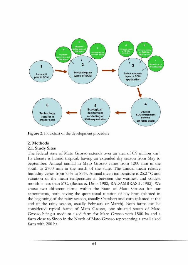
64
Figure 2: Flowchart of the development procedure
2. Methods 2.1. Study Sites The federal state of Mato Grosso extends over an area of 0.9 million km². Its climate is humid tropical, having an extended dry season from May to September. Annual rainfall in Mato Grosso varies from 1200 mm in the south to 2700 mm in the north of the state. The annual mean relative humidity varies from 73% to 85%. Annual mean temperature is 25.2 °C and variation of the mean temperature in between the warmest and coldest month is less than 5°C. (Bastos & Diniz 1982, RADAMBRASIL 1982). We chose two different farms within the State of Mato Grosso for our experiments, both having the quite usual rotation of soy bean (planted in the beginning of the rainy season, usually October) and corn (planted at the end of the rainy season, usually February or March). Both farms can be considered typical farms of Mato Grosso, one situated south of Mato Grosso being a medium sized farm for Mato Grosso with 1500 ha and a farm close to Sinop in the North of Mato Grosso representing a small sized farm with 200 ha.

65
2.1 Experimental Setup We used three different types of organic matter addition including two different types of compost, fresh compost, consistent of freshly cut, almost not at all decomposed organic matters like sawdust and coarse eucalyptus parts of the bark, and also of already pre-decomposed organic matter types like maracuja pulp (decomposed for a few weeks) or the filter cake of the sugar-cane (decomposed for a few months) (Fig. 3 and Fig. 4). The third type of organic matter application is an additional rotation of the leguminous plant Crotalaria ochroleuca and the mixture of C. ochroleuca and Brachiaria ruziziensis (Fig. 4). For bulk density analyses we collected soil cores with a soil sampler for undisturbed soil samples with 100ml steel cylinders, taking samples every five centimeters for the first 20 centimeters of the upper soil horizon (four samples for every horizon). Bulk density was determined gravimetrically from undisturbed soil cores collected in metal cylinders and
dried at 105°C (AG-Boden 2005). For all other analyses we collected disturbed soil samples from dug soil profiles, taking samples every five centimeters for the first 20 centimeters of the upper soil horizon (four samples for every horizon). Analyses are being carried out on dried samples of the fine-earth fraction (samples from each depth were dried at max. 60°C, than sieved through a <2-mm mesh to obtain the fine
Figure 3: Organic matter amendment at the experimental site “Rio Engano Farm” in Mato Grosso, Brazil
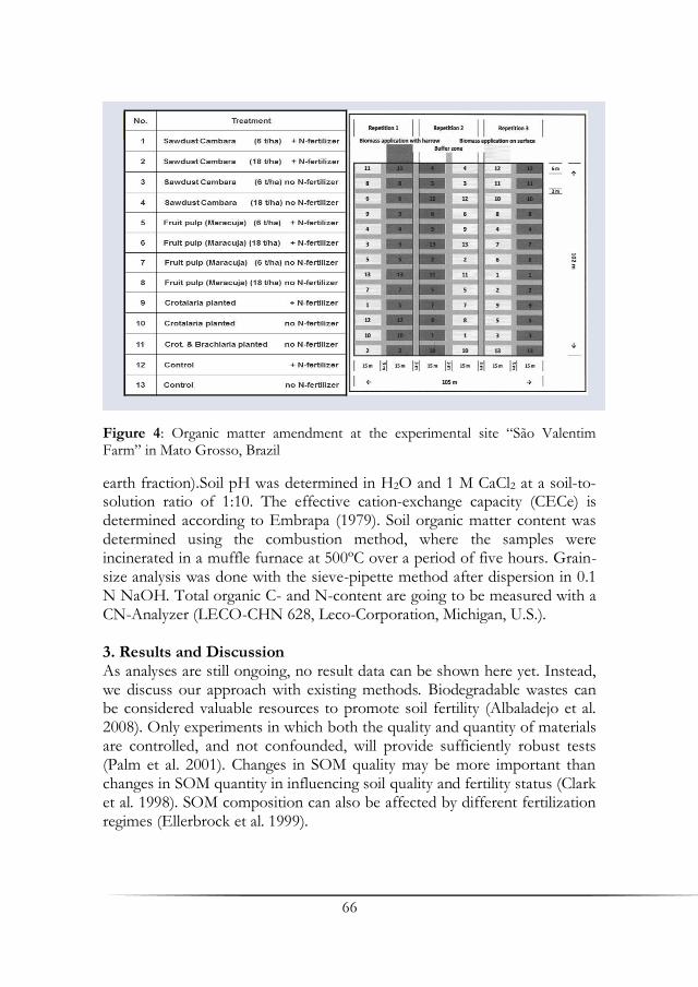
66
Figure 4: Organic matter amendment at the experimental site “São Valentim Farm” in Mato Grosso, Brazil
earth fraction).Soil pH was determined in H2O and 1 M CaCl2 at a soil-to-solution ratio of 1:10. The effective cation-exchange capacity (CECe) is determined according to Embrapa (1979). Soil organic matter content was determined using the combustion method, where the samples were incinerated in a muffle furnace at 500ºC over a period of five hours. Grain-size analysis was done with the sieve-pipette method after dispersion in 0.1 N NaOH. Total organic C- and N-content are going to be measured with a CN-Analyzer (LECO-CHN 628, Leco-Corporation, Michigan, U.S.). 3. Results and Discussion As analyses are still ongoing, no result data can be shown here yet. Instead, we discuss our approach with existing methods. Biodegradable wastes can be considered valuable resources to promote soil fertility (Albaladejo et al. 2008). Only experiments in which both the quality and quantity of materials are controlled, and not confounded, will provide sufficiently robust tests (Palm et al. 2001). Changes in SOM quality may be more important than changes in SOM quantity in influencing soil quality and fertility status (Clark et al. 1998). SOM composition can also be affected by different fertilization regimes (Ellerbrock et al. 1999).

67
A recent review (Diacono & Montemurro 2010) cites a considerable number of long-term studies, mostly using waste products of the urban and rural sector (bio waste compost like cattle manure (liquid, semiliquid, dried, raw, composted), compost (paddy rice and barley), digested bio solids, green manuring, maize for silage, municipal solid waste, sawdust compost, straw (raw, burned, composted), urban organic waste, composted and uncomposted wastewater sludge). Apart from two studies from Punjab, India, none of the cited studies were performed in the Tropics. A general result of a recent review on SOC enrichment in nutrient poor soils concludes that the effect of soil organic carbon on crop productivity is mainly due to improved organic N supply to crops (Gaiser & Stahr 2013). Moreover, positive correlations between organic matter addition to soils and increasing water retention capacity were found, especially in sandy soils, which have a small capacity for water retention due to their huge grain size, field capacity is especially defined by humus content (Hollis et al. 1977, da Silva & Kay 1997, Wessolek et al. 2008). Conversion of biomass C to bio-char C may lead to sequestration of about 50% of the initial C compared to the low amounts retained after burning (3%) and biological decomposition (<10–20% after 5–10 years), therefore bio char is considered to yield more stable soil C than burning or direct land application of biomass (Lehmann et al. 2006). Our argument in favor of a direct application of organic matter of different types is that this more natural process will affect the soil structure by allowing the synchronous occurrence of differently decomposed organic matter, which may have a positive effect on the soil biota and soil physics. Moreover, the integration of organic matter addition by root-producing intercrops, as already partly executed in the projects of Carbiocial and Carbioma, may provide pathways for integrating agriculture in a larger landscape context that provides ecological corridors for non-agriculturally used species in the agroscape and that helps to support the water balance in large tropical agroscapes.
References
Ad-hoc-Arbeitsgruppe Boden (2005): Bodenkundliche Kartieranleitung, Hrsg.: Bundesanstalt für Geowissenschaften und Rohstoffe in Zusammenarbeit mit den Staatlichen Geologischen Diensten, 5. ed., Hannover.
Albaladejo, J., Lopez, J., Boix-Fayos, C., Barbera, G. G., Martinez-Mena, M. (2008): Long-term Effect of a Single Application of Organic Refuse on Carbon Sequestration and Soil Physical Properties. J. Environ. Qual. 37: 2093-2099.
Bastos, T. X., Diniz, A. S. (1982): Avaliação do clima do estado de Rondônia para desenvolvimento agrícola. Boletim de Pesquisa, vol. 44. Embrapa, Belém.
68
Castro Filho, C., Vieira, M. J., Casão Jr., R. (1991): Tillage methods and soil and water conservation in southern Brazil. Soil Till. Res. 20: 271–283.
Clark, M. S., Horwarth, W. R., Shennan, C., Scow, K. M. (1998): Changes in soil chemical properties resulting from organic and low-input farming practices. Agronomy Journal 90: 662-671.
da Silva, A. P., Kay, B. D. (1997): Estimation the least limiting water range of soils from properties and management. Soil Sci. Soc. Am. J. 61: 877-883.
Denef, K., Six, J., Bossuyt, H., Frey, S. D., Elliott, E. T., Merckx, R., Paustian, K. (2001): Influence of dry–wet cycles on the relationship between aggregate, particulate organic matter, and microbial community dynamics. Soil Biol. Biochem. 33: 1599-1611.
Diacono, M., Montemurro, F. (2010): Long-term effects of organic amendments on soil fertility. A review. Agron. Sustain. Dev. 30: 401–422.
Doran, J. W. (1997): Soil quality and sustainability. In: Proceedings of the XXVI Brazilian Congress of Soil Science, 20–26th July. Rio de Janeiro.
Dutschke, M., T. Pistorius, T. (2008): Will the future be REDD? Consistent carbon accounting for land use. International Forestry Review 10: 476-484.
Ellerbrock, R. H., Hoehn, A., Rogasik, J. (1999): Functional analysis of soil organic matter as affected by long-term manorial treatment. European Journal of Soil Science 50: 65-71.
Embrapa (1979): Serviço Nacional de Levantamento e Conservação de Solos (Rio de Janeiro, RJ). Manual de métodos de análise de solo. Rio de Janeiro.
Feller, C., Albrecht, A., Blanchart, E., Cabidoche, Y. M., Chevallier, T., Hartmann, C., Eschenbrenner, V., Larré-Larrouy, M. C., Ndandou, J. F. (2001): Soil organic carbon sequestration in tropical areas. General considerations and analysis of some edaphic determinants for Lesser Antilles soils. Nutrient Cycling in Agroecosystems 61: 19-31.
Franzluebbers, A. J. (2002a): Soil organic matter stratification ratio as an indicator of soil quality. Soil Till. Res. 66: 95–106.
Franzluebbers, A. J., (2002b): Water infiltration and soil structure related to organic matter and its stratification with depth. Soil Till. Res. 66: 197–205.
Gaiser, T., Stahr, K. (2013): Soil Organic Carbon, Soil Formation and Soil Fertility. In R. L. Lal, K., Hüttl, R. F., Schneider, B. U., von Braun, J. (eds.): Ecosystem Services and Carbon Sequestration in the Biosphere. Springer, New York, p. 407-418.
Golchin, A., Oades, J. M., Skjemstad, J. O., Clarke, P. (1994): Study of free and occluded particulate organic matter in soils by solid state 13C CP/MAS NMR spectroscopy and scanning electron microscopy. Australian Journal of Soil Research, 32: 285–309.
Grainger, A. (1995): Modeling the anthropogenic degradation of drylands and the potential to mitigate global climate change. In: Squires, V. R., Glenn, E. P., Ayoub, T. A. (eds.): Global climate change by combating land degradation. UNEP, Nairobi, p. 193–199.

69
Hollis, J. M., Jones, R. J. A., Palmer, R. C. (1977): The effect of organic matter and particle size on the water retention properties of some soils in the West Midlands of England. Geoderma 17: 225-238.
Lehmann, J., Gaunt, J., Rondon, M. (2006): Bio-char Sequestration in Terrestrial Ecosystems – A Review. Mitigation and Adaptation Strategies for Global Change 11: 395-419.
Jenny, H. (1941): Factors of soil formation. McGraw-Hill, New York. Mondini C., Sequi P. (2008: Implication of soil C sequestration on sustainable
agriculture and environment, Waste Management 28: 678–684. Palm, C. A., Giller, K. E., Mafongoya, P. L., Swift , M. J. (2001): Management of
organic matter in the tropics: translating theory into practice. Nutrient Cycles in Agroecosystems 61: 63–75.
Quideau, S. A., Anderson, M. A., Graham, R. C., Chadwick, O. A., Trumbore, S. (2000): Soil organic matter processes: characterization by 13C NMR and 14C measurements. Forest Ecol. Management 138: 19–27.
Stewart, C. E., Paustian, K., Conant, R. T., Plante, A. F., Six, J. (2007): Soil carbon saturation: concept, evidence and evaluation. Biogeochemistry 86: 19-31.
Swift, M. J., Heal, O. W., Anderson, J. M. (1979): Decomposition in Terrestrial Ecosystems. Blackwell Scientific, Oxford.
Tiessen, H., Cuevas, E., Chacon, P. (1994) : The role of soil organic matter in sustaining soil fertility. Nature 371:783–785.
Tisdall, J. M., Oades, J. M. (1982): Organic matter and water stable aggregates in soils. J. Soil Sci. 33: 141–163.
Wessolek, G., Kaupenjohann, M., Dominik, P., Ilg, K., Schmitt, A., Zeitz, J., Gahre, F., Schulz, E., Ellerbrock, R., Utermann, J., Düwel, O., Siebner, C. (2008): Ermittlung von Optimalgehalten an organischer Substanz landwirtschaftlich genutzter Böden nach § 17 (2) Nr. 7 BBodSchG. Forschungsprojekt im Auftrag des Umweltbundesamtes FuE-Vorhaben. Förderkennzeichen 202 71 264. Berlin.


71
Impacts of Land Cover and Climate Change on
Hydrology and Hydrochemistry in Selected Catchments in Southern Amazonia:
Preliminary Analysis and Results
Alphonce C. Guzha1, Ricardo S. S. Amorim2, Rodolfo Nóbrega1, Gabriele Lamparter1, Kristof Kovacs1, Norma Bertão2 & Gerhard Gerold1
1Department of Landscape Ecology. Georg-August University, Göttingen 2Faculty of Agronomy, Veterinary Medicine, and Zootechnology (FAMEVZ), Federal University of Mato Grosso, Cuiabá
Summary In this study we evaluate the impacts of land cover changes on hydrology and hydrochemistry in the Amazon and cerrado biomes, with the help of field investigation and simulation modeling. In five micro-catchments covered by native forest, cerrado vegetation, pasture and cropped land in the states of Mato Grosso and Pará, Brazil we collected hydrological and hydro chemical data in wet and dry seasons. We also applied the Soil & Water Assessment Tool model, to evaluate hydrological responses for different land use scenarios (deforestation, cropland and pasture expansion. Preliminary results show that land cover changes alter the hydrological regime. For example, the pasture catchment exhibit significantly higher discharges compared to the forest catchment. Base flow contribution was lower and overland flow higher, resulting in a swift response to rainfall in the pasture micro-catchment. Hydro chemical analysis in general showed very low carbon and nutrient concentrations. Still, during storm events concentrations of Total Organic Carbon went up to 20 times compared to base flow. Simulation results showed that land use changes result in increases in surface runoff and water yield (4-8%) and decreases in evapotranspiration, soil water infiltration and base flow (5-13%). Key words: catchment hydrology, water quality, Amazon, land cover change, climate change

72
1. Introduction Land cover alterations and climatic change are among the most important factors influencing various components of the hydrologic budget such as evaporation, surface runoff, infiltration and groundwater recharge. Despite years of research, many questions remain concerning the impact of land cover changes and climate change on water resources. Such questions are especially relevant in the Amazon River basin where severe climate shifts and deforestation are already threatening the region. Studies in meso- and macro-scale catchments have shown that deforestation results in an increase in annual stream flows (e.g. Costa et al. 2003, Siriwardena et al. 2006). However, Kashaigili (2008) observed only base flow reductions and Wilk et al. (2001) were unable to detect any change in hydrological regimes in watershed with significant deforestation. These inconsistencies could be attributed to differences in climatic setting, topography and catchment morphology, in soil properties and differences in land cover types.
Against this background of partly contradicting findings, this research aims to quantify the annual fluxes of stream discharges in head water catchments and assess their importance relative to nutrient transport and carbon storage. The overall objectives of our study are therefore, to: (i) quantify watershed and catchment water balance for different land use conditions; (ii) measure catchment stream solutes and carbon dynamics for different land use conditions; (iii) estimate catchment scale sediment transport at the storm event scale for different land use conditions; (iv) relate flow conditions at seasonal scale with the variation of solutes and carbon in stream water during base flow and storm flow conditions; and (v) use predictive tools (models) to enhance our understanding of the above mention processes for different land cover management and climatic scenarios.
2. Methods 2.1 Study Site The detailed small-scale hydrological and hydro chemical investigations are carried out in two different study regions (Mato Grosso and Pará) within the legal Amazon (Fig. 1). In Mato Grosso, the experimental microcatchments (<1 km2) are located on three farms, Fazenda Santa Luzia, Fazenda Rancho Do Sol and Fazenda Gianetta, about 30 km south west of Campo Verde (15.56°S, 55.16°W). The climate is tropical, hot and humid, with temperatures ranging from 18ºC to 35ºC.and annual rainfall average is 1750 mm. The experimental catchments in Pará are located at Fazenda Paraíso (7.042°S, 55.38°W), which is about 5 km from the town of

73
Figure 1: Location of the five catchments in the states of Pará and Mato Grosso
Figure 2: The upper Rio das Mortes watershed in Mato Grosso
74
Novo Progresso in and situated in the watershed of the Jamanxim River, one of the sub-tributaries of the Amazon River. The climate in the study area is humid tropical with mean annual precipitation of 1900 mm. All micro-catchments are covered by one uniform land use type (Fig. 1). The SWAT model (Soil & Water Assessment Tool model) was applied to the upper Rio das Mortes watershed (Fig. 2) located in Mato Grosso, Brazil and covers an area of 17555 km². Land use in this region is predominantly agricultural (maize, cotton and soybeans). 2.2 Instrumentation and Hydrological Observations in the Micro-Catchments Topographic Surveys: Terrestrial Laser Scanning (TLS) survey was used to develop digital elevation models for the cropland and pasture catchments. In densely vegetated catchments with cerrado and forest vegetation, a dGPS survey instrument was used together with a TOPCON-GRS1 GPS. In the gallery forests, a TOPCON-GRS1 GPS with an integrated TruPulse 360°B distance measurement system, was used and ASTER Global DEM v2 datasets were utilized to complement the post-processing work.
Rainfall and Weather Data: Four tipping buckets (0.2mm resolution) with data loggers (Tinytag, Gemini, UK) were installed in each micro-catchment. Weather stations were installed within each study region to measure total solar radiation, net solar radiation, temperature, relative humidity, wind speed and direction and rainfall at 10 minute time intervals.
Catchment Discharge: At each micro-catchment outlet, rectangular weirs were constructed and the impounded water fitted with DS 5X multiparameter sondes (OTT) measuring water level, electrical conductivity, pH, turbidity, dissolved oxygen (LDO) and temperature at 15-minute intervals. The standard rectangular weir equation based on the Bernoulli equation was used to estimate discharge.
Water Quality Analysis: Stream flow was sampled automatically using a Buehler 2000 auto-samplers. The sampling followed two routines: regular interval (daily during the wet season, and 3 days during the dry season) and one event based routine (triggered by rising stage). The samples were analyzed in the laboratory for total and dissolved organic carbon (TOC/ DOC), cations (Al3+,Ca2+, K+, Mg2+, Na+ and Si) and anions (F-,Cl-, NO3-, PO42- and SO42-). Soil Properties: Along two topological transects in each catchment 200cm deep access tubes were installed. In these tubes soil moisture was recorded on frequent intervals with a TRIME-PICO T3 probe (IMKO Micromodultechnik GmbH, Ettlingen, Germany) at 20 cm depth intervals.

75
2.3 Soil Water Assessment Tool (SWAT) Model SWAT is a continuous, physically based, semi-distributed hydrologic model first created by the US Department of Agriculture (USDA) and the Texas Experimental Station (TES) in the early 1990s. It calculates and routes water, sediments and contaminants from individual drainage sub-basins towards the outlet and has been widely used to predict the impact of management practices on water, nutrient and sediments in basins with varying soils, land use and management conditions A full description is given in Arnold & Fohrer (2005).
In this study, climate data of the National Center of Environmental Prediction (NCEP) for 1980-2010 was used. Discharge data from two stations (ANA 26040000 and ANA 26050000) was used for model calibration and validation. Measured discharge data for the period of 1985 to 1995 was used for model calibration while the period 1996-2001 was used for model validation.
Two land cover scenarios were selected (Fig. 3). These two scenarios are based on likely future changes in land cover in the watershed as dictated by economic drivers such as value of crops and depreciation in value of livestock. The land cover classes of the Rio das Mortes watershed were created by LANDSAT imagery from the 2009-2012 time series. In the first scenario small pastures have been converted into cropland around the cropland areas. In the second scenario, all pasture areas were converted into cropland and, all cerrado land use categories were transformed into pasture.
For the analysis of land use change impacts on the water balance components, two model runs were performed and only model parameters that were defined by the land use map were different in the two model setups. Therefore, the number of hydrologic response units (HRUs), which are unique land use-soil-slope combinations, differed in the two model setups.
3. Results and Discussion Stream Discharge and Catchment Hydrological Fluxes on Micro-Catchment Scale: Preliminary results from a comparison of hydrological regimes in neighboring pasture and forest micro-catchments in the Novo-Progresso study area show that the pasture catchment exhibits higher instantaneous peak discharges compared to the forest catchment (Fig. 4).Normalized discharge was higher in the pasture catchment which also exhibited a higher runoff ratio (0.79) compared to the forest catchment (0.56). Average Base Flow Index was 0.74 for the forest catchment and 0.60 for the pasture
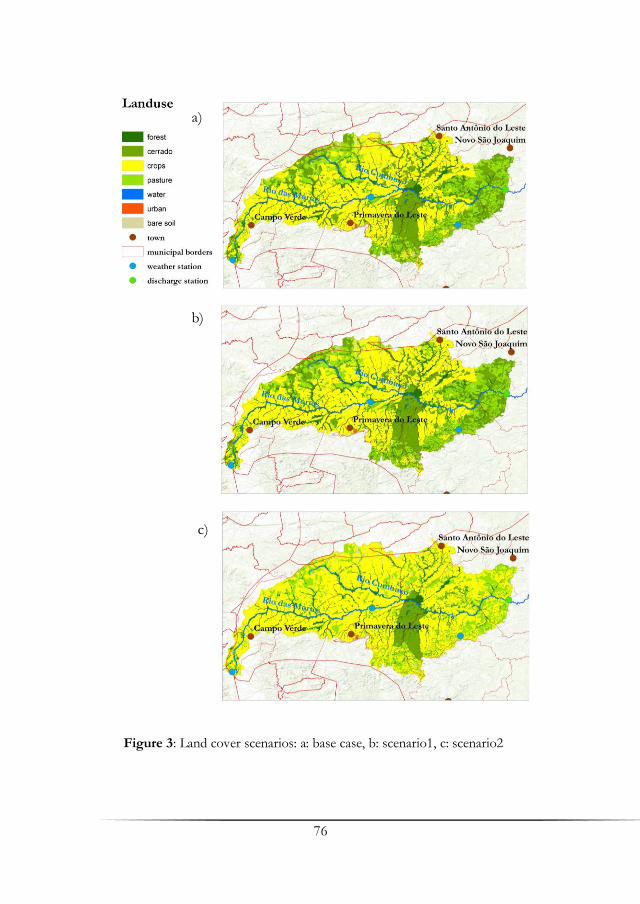
76
Figure 3: Land cover scenarios: a: base case, b: scenario1, c: scenario2
b) (Figure 4)
a)
c)
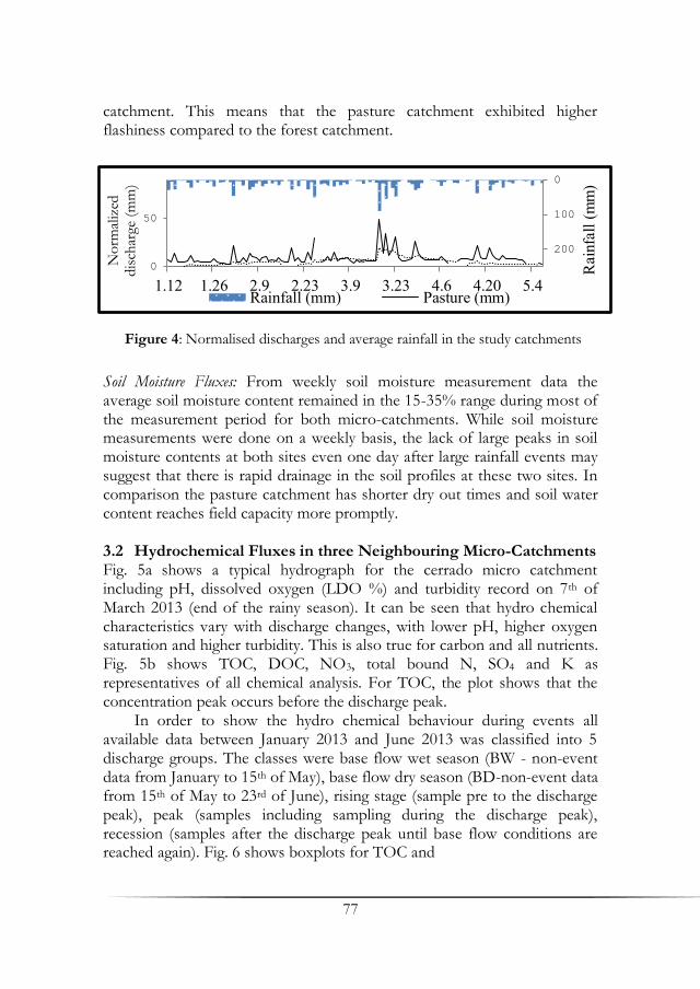
77
catchment. This means that the pasture catchment exhibited higher flashiness compared to the forest catchment.
Soil Moisture Fluxes: From weekly soil moisture measurement data the average soil moisture content remained in the 15-35% range during most of the measurement period for both micro-catchments. While soil moisture measurements were done on a weekly basis, the lack of large peaks in soil moisture contents at both sites even one day after large rainfall events may suggest that there is rapid drainage in the soil profiles at these two sites. In comparison the pasture catchment has shorter dry out times and soil water content reaches field capacity more promptly. 3.2 Hydrochemical Fluxes in three Neighbouring Micro-Catchments Fig. 5a shows a typical hydrograph for the cerrado micro catchment including pH, dissolved oxygen (LDO %) and turbidity record on 7th of March 2013 (end of the rainy season). It can be seen that hydro chemical characteristics vary with discharge changes, with lower pH, higher oxygen saturation and higher turbidity. This is also true for carbon and all nutrients. Fig. 5b shows TOC, DOC, NO3, total bound N, SO4 and K as representatives of all chemical analysis. For TOC, the plot shows that the concentration peak occurs before the discharge peak. In order to show the hydro chemical behaviour during events all available data between January 2013 and June 2013 was classified into 5 discharge groups. The classes were base flow wet season (BW - non-event data from January to 15th of May), base flow dry season (BD-non-event data from 15th of May to 23rd of June), rising stage (sample pre to the discharge peak), peak (samples including sampling during the discharge peak), recession (samples after the discharge peak until base flow conditions are reached again). Fig. 6 shows boxplots for TOC and
0
100
200
0
50
1.12 1.26 2.9 2.23 3.9 3.23 4.6 4.20 5.4
Rai
nfal
l (m
m)
No
rmal
ized
dis
char
ge (
mm
)
Rainfall (mm) Pasture (mm)
Figure 4: Normalised discharges and average rainfall in the study catchments
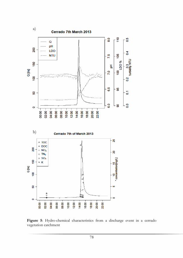
78
Figure 5: Hydro-chemical characteristics from a discharge event in a cerrado vegetation catchment
b)
a)
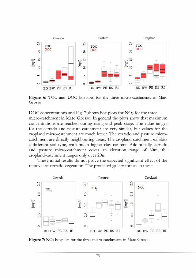
79
Figure 6: TOC and DOC boxplots for the three micro-catchments in Mato Grosso
DOC concentrations and Fig. 7 shows box plots for NO3 for the three micro-catchment in Mato Grosso. In general the plots show that maximum concentrations are reached during rising and peak stage. The value ranges for the cerrado and pasture catchment are very similar, but values for the cropland micro-catchment are much lower. The cerrado and pasture micro-catchment are directly neighbouring areas. The cropland catchment exhibits a different soil type, with much higher clay content. Additionally cerrado and pasture micro-catchment cover an elevation range of 60m, the cropland-catchment ranges only over 20m. These initial results do not prove the expected significant effect of the removal of cerrado vegetation. The protected gallery forests in these
Figure 7: NO3 boxplots for the three micro-catchments in Mato Grosso

80
catchments could be buffer zones. Moreover data from the cropland micro-catchment shows that intensive agriculture results in only minimal rising nitrate runoff. Again the buffer function of the gallery forest is probably a key factor. Application of the SWAT Model on the Upper Rio das Mortes Macro-Catchment: Model parameters were varied in order to approximate the modeled stream low to measured stream flow at the two gauging stations. Within the limits of the calibration parameter range, generally and based on the summary statistics in Tab. 1 and Fig. 8 and Fig. 9, the model is considered acceptable for use in evaluating results from different alternative scenarios such as land cover.
Table 1: Summary statistics for model calibration and validation
Discharge
Station R2 NS
Mean measured discharge
(m3/s)
Mean modeled discharge
(m3/s)
Calibration Rio Das Mortes 0.80 0.63 127 148
Toriqueje 0.82 0.58 389 418
Validation Rio Das Mortes 0.60 0.51 116 137
Toriqueje 0.50 0.48 374 401
(a) (b) Figure 8: Measured and simulated discharge at two gauging stations (a) Toriqueje and (b) Rio Das Mortes for model calibration period
0200400600800
100012001400160018002000 R² = 0,8208
0
200
400
600
800
1000
1200
0 200 400 600 800 1000 1200
Sim
ulat
ed d
isch
arge
(m
3 /s)
Measured discharge (m3/s)
0
100
200
300
400
500
600
observed discharge (m3/s)
simulated discharge (m3/s)
R² = 0,8076
050
100150200250300
0 50 100 150 200 250 300Sim
ulat
ed d
isch
arge
(m
3 /s)
Measured discharge (m3/s)
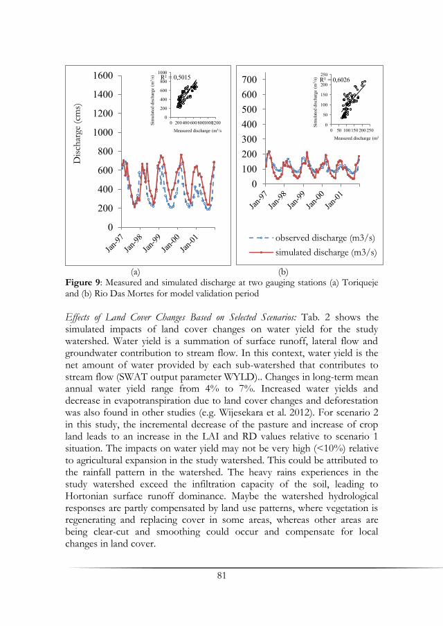
81
(a) (b) Figure 9: Measured and simulated discharge at two gauging stations (a) Toriqueje and (b) Rio Das Mortes for model validation period
Effects of Land Cover Changes Based on Selected Scenarios: Tab. 2 shows the simulated impacts of land cover changes on water yield for the study watershed. Water yield is a summation of surface runoff, lateral flow and groundwater contribution to stream flow. In this context, water yield is the net amount of water provided by each sub-watershed that contributes to stream flow (SWAT output parameter WYLD).. Changes in long-term mean annual water yield range from 4% to 7%. Increased water yields and decrease in evapotranspiration due to land cover changes and deforestation was also found in other studies (e.g. Wijesekara et al. 2012). For scenario 2 in this study, the incremental decrease of the pasture and increase of crop land leads to an increase in the LAI and RD values relative to scenario 1 situation. The impacts on water yield may not be very high (<10%) relative to agricultural expansion in the study watershed. This could be attributed to the rainfall pattern in the watershed. The heavy rains experiences in the study watershed exceed the infiltration capacity of the soil, leading to Hortonian surface runoff dominance. Maybe the watershed hydrological responses are partly compensated by land use patterns, where vegetation is regenerating and replacing cover in some areas, whereas other areas are being clear-cut and smoothing could occur and compensate for local changes in land cover.
0100200300400500600700
observed discharge (m3/s)
simulated discharge (m3/s)
R² = 0,6026
0
50
100
150
200
250
0 50 100 150 200 250
Sim
ulat
ed d
isch
arge
(m
3 /s)
Measured discharge (m3/s)
0
200
400
600
800
1000
1200
1400
1600D
isch
arge
(cm
s)
R² = 0,5015
0
200
400
600
800
1000
0 200400 60080010001200Sim
ulat
ed d
isch
arge
(m
3 /s)
Measured discharge (m3/s

82
Table 2: Simulated changes in water yield (WYLD), at watershed outlet (Toriqueje gauging station), for the different land cover scenarios and for different rainfall patterns
Scenario PRECIP (mm) WYLD (mm) % Change in WYLD
Baseline 1 2
2024 1237 1280 1288
3% 4%
Baseline 1 2
1484 815 860 873
6% 7%
4. Conclusions Our preliminary results from field experimentation and modeling show higher discharge for deforested pasture catchments compared to its native forest catchment. Runoff volumes and their temporal variation were adequately captured by the SWAT model. Long-term land use changes have been shown to have effects on hydrological processes in river basins. Urbanization and agriculture are presumed to be the major environmental stressors affecting watershed condition. Results from this study indicate that the water balance in the watershed showed greater changes under land cover scenario 2 compared to the baseline scenario, demonstrating different sensitivity to land use changes for the two land cover scenarios. However, hydro chemical data, is not sufficient to prove higher carbon and nutrient discharge of degraded areas compared to undisturbed catchments. More hydro chemical analyses and further work on soil profile (hydraulic) characterization and surface runoff measurement in field plots are activities planned for the next phase of field experimentation. The results presented here provide a useful initial assessment of catchment hydrological and hydro-chemical dynamics in catchments and watersheds under varying land cover characteristics References Arnold J. G., Fohrer, N. (2005): SWAT2000: Current capabilities and research
opportunities in applied watershed modeling. Hydrological Processes 19: 563–572.
Costa, M. H., Botta, A., Cardille, J. (2003): Effects of large-scale changes in land cover on the discharge of the Tocantins River, Southeastern Amazonia. Journal of Hydrology 283: 206-217.

83
Kashaigili, J. J. (2008): Impacts of land-use and land-cover changes on flow regimes of the Usangu wetland and the Great Ruaha River, Tanzania. Elsevier Journal of Physics and Chemistry of the Earth 33: 640-647.
Siriwardena, L., Finlayson, B. L., McMahon, T. A. (2006): The impact of land use change on catchment hydrology in large catchments: The Comet River, Central Queensland, Australia. Journal of Hydrology 326: 199-214.
Wijesekara, N., Gupta, A., Valeo, C., Hasbani, J. G., Qiao, Y., Delaney, P., Marceau, D. J. (2012): Assessing the impact of future land-use changes on hydrological processes in the Elbow River watershed in southern Alberta, Canada. Journal of Hydrology 412-413: 220-232.
Wilk, K., Andersson, L., Plermkamon, V. (2001): Hydrological impacts of forest conversion to agriculture in a large river basin in northeast Thailand. Hydrological Processes 15: 2729–2748.
Microcatchment weir in Campo Verde, Mato Grosso


85
Effects of Contour Banks and No-Till Measures
on Run-Off and Sediment Yield in Campo Verde Region, Mato Grosso
Marcus Schindewolf1, Daniela Schönke1, Ricardo S. S. Amorim2 & Jürgen Schmidt1
1Soil and Water Conservation, Technical University of Freiberg, Freiberg 2Faculty of Agronomy, Veterinary Medicine, and Zootechnology (FAMEVZ), Federal University of Mato Grosso, Cuiabá
Summary The process based soil loss model EROSION 2D is used for simulation of soil erosion, sediment transport and deposition on sloped cropland in Campo Verde region of Mato Grosso. Since contour banks and no-till measures are well established tools in local agricultural management, the study targets on estimating protection potential of both measures. In this context scenario simulations figured out a high protection potential of no-till measures. In combination with contour banks water and soil losses can almost be avoided. Even in case of conventional tillage contour banks prevent runoff and soil loss efficiently. Merely very heavy rainfall events result in an overflowing of contour banks related to a decreasing protection potential. Rainfall experiments confirm the general influence of soil management on surface runoff and sediment yields. Highest infiltration rates of 0.89 mm*m-2 and lowest runoff sediment concentrations of 0.32 g*L-1 were found under no-till measures.
Key words: EROSION 2D, erosion, process based, no-till, conventional tillage, soy, corn, cotton
1. Introduction Based on the present knowledge the study area is highly affected by soil erosion causing substantial environmental and economic problems. Taking account of ongoing deforestation and regional climate change it is to be
86
expected that future erosion rates may increase significantly (Favis-Mortlock & Guerra 1997).
As the agriculture frontier expand to the Mato Grosso State contour banks were used as a suitable tool for preventing soil losses under conservation tillage measures (Landers 2001). However, erosion still occurred between the banks and by overtopping of contour banks. To combat these problems no-till measures were applied (Landers 2007). Due to the high impact of no-till measures on soil loss reduction farmers tend to remove contour banks in order to plant in straight lines underestimating the effects of very rare extreme rainfall events (Landers 2001). Additionally, a conversion into conventional tillage measures especially for cotton production may increase the risk of serious erosional soil and nutrient losses.
Due to the highly complex nature of the physical processes involved, monitoring and surveying of soil erosion processes is associated with many difficulties. In most cases direct measurements of soil loss are limited to small experimental plots with either natural or simulated rain fall (Leite et al. 2009, Silva et al. 2005). Still, on these plots the relevant hydraulic conditions of erosion cannot be completely reproduced. For the same reasons, plot measurements cannot be directly transferred to natural slopes and watersheds without taking the differing hydraulic conditions into account (Amorim et al. 2001). In order to overcome these problems mathematical simulation models have been developed starting with the Universal Soil Loss Equation (USLE) by (Wischmeier & Smith 1978). Whereas the USLE was derived by correlating empirical data more recently developed soil erosion models mainly use physically based approaches which allow adequate representation and quantitative estimation of erosion (soil detachment and transport) and deposition. Furtheron only annual means are simulated using USLE, while the high impact of rare extreme events is neglected, which avoids an application of USLE for planning and dimensioning of erosion mitigation measures e.g. contour banks. In this regard only process based models are able to focus on that challenge. Due to the high data demands they are predominantly applied on well observed small catchments ore single slopes. 2. Methods 2.1 Study Site The study area is located in the Campo Verde region of Mato Grosso the former cerrado biome, which is now intensively used for agriculture. More than 50% of this native forest was transformed into cropland and pasture (Silva et al. 2006). Now the landscape is fragmented by land use of vast

87
croplands and pastures and small remaining parts of cerrado or gallery forest (Arvor et al. 2012).
The tropical winter dry rain climate of the region is characterized by 1448 mm annual rainfall and a mean temperature of 22°C for the Campo Verde climate station. More than 90% of the rainfall occurs in the rainy season the between October and April often in connection with convective rains. Because of two planting periods temporarily low plant cover may provoke erosive soil losses.
Figure 1: Location of the investigated slope
The study area is located on a plateau between 600-700 m above the sea level. Wide plains and low slopes of max. 2-6% are typical for that region.
Widespread deeply weathered Ferralsols are characterized by low pH and cation exchange capacity. In order to overcome high soil acidity and low nutrient availability soils are improved by liming and mineral fertilization. Common soils tend to generate water stable aggregates known as pseudo sand, which modifies clayey into sandy soil textures involving soil erodibility and soil water balance.
The former cerrado vegetation of this region was deforested in the mid 70ies for pastoral and cropland use. As a consequence of the rapid soil degradation due to soil erosion and losses of essential nutrients many farmers converted into no-till measures for soy-corn monoculture. Since marked prices increased for cotton increased in 2010 many farmers changed to a soy-cotton crop rotation. Cotton production in this region is only possible under conventional tillage normally using disc harrow, which again causes problems of soil erosion. Extreme events force the farmers to reconstruct the former contour banks.
88
2.2 The Erosion 2D Model EROSION 2D is a slope scaled physically based soil erosion model that predicts the spatiotemporal distribution of erosion and deposition as well as the delivery of suspended soil material to surface water courses (Schmidt 1996). Over more than 15 years the model was continually improved and extensively validated using plot and catchment based soil erosion data. The theoretical concept of the model is based on the assumption that the erosive impact of overland flow and rainfall droplets is proportional to the momentum flux exerted by the flow and falling droplets respectively. In detail the model covers the following physical processes in time and space: rainfall infiltration, excess rainfall and subsequent generation of surface runoff, detachment of soil particles by raindrop impact and surface runoff, transport of detached soil particles by surface runoff and grain size dependent sediment deposition.
The model runs with comparable low number of input parameters concerning relief, rainfall and initial soil conditions. Overflowing of contour banks could not be simulated directly. Mean retention volume has to be known to deliver surplus of runoff and sediment manually.
2.3 Model Parameters The shape of the test slope was evaluated using SRTM data. Regarding the effect of contour banks was measured with a leveling board and a water-level, whereas distance between the banks was determined by GPS. This information was inserted into the slope profile afterwards.
Due to the lack of measured rainfall events the empirical function
of Garcia et al. 2011 was used to determine mean rainfall intensity
[mm/h] for block rains of varying recurrence intervals [y] and rainfall
duration [min] near the climate station of Cuiabá (see eq. 1). Events refer to the 10, 20, 50 and 100 years rainfall event of 10 or 20 min rainfall duration.
Equation 1:
EROSION 2D soil inputs were derived using soil samples and rainfall simulations. All soil samples were taken in 10 cm soil depth. Texture analysis of one mixed sample per plot was conducted via Köhn-sieve-sedimentation method using mechanical dispersion with ultrasound. Bulk density and initial soil moisture content were measured gravimetrically in six
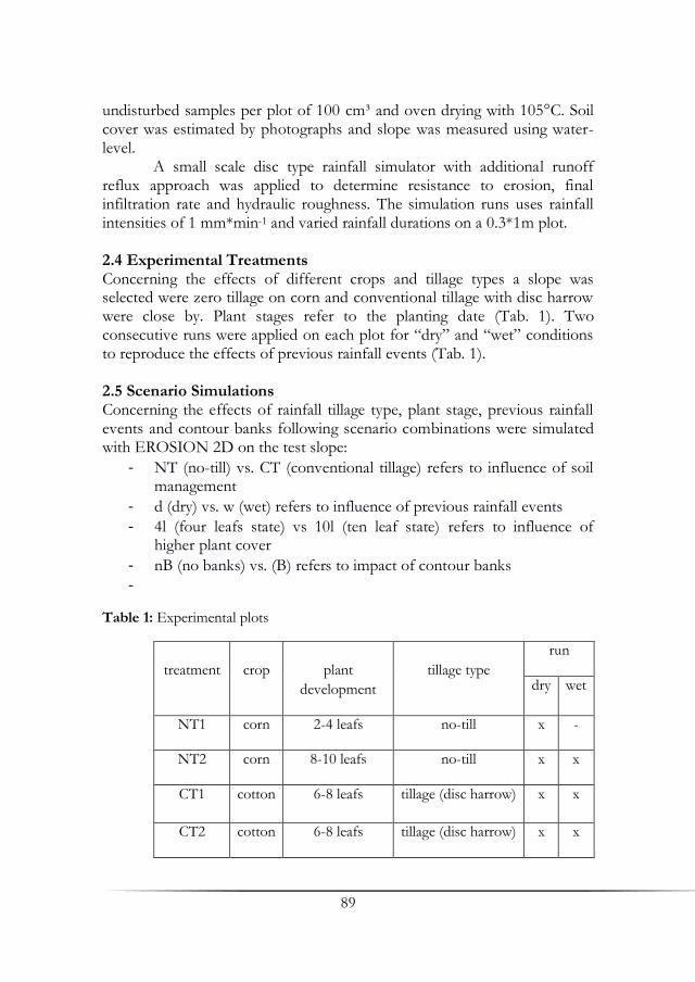
89
undisturbed samples per plot of 100 cm³ and oven drying with 105°C. Soil cover was estimated by photographs and slope was measured using water-level.
A small scale disc type rainfall simulator with additional runoff reflux approach was applied to determine resistance to erosion, final infiltration rate and hydraulic roughness. The simulation runs uses rainfall intensities of 1 mm*min-1 and varied rainfall durations on a 0.3*1m plot.
2.4 Experimental Treatments Concerning the effects of different crops and tillage types a slope was selected were zero tillage on corn and conventional tillage with disc harrow were close by. Plant stages refer to the planting date (Tab. 1). Two consecutive runs were applied on each plot for “dry” and “wet” conditions to reproduce the effects of previous rainfall events (Tab. 1). 2.5 Scenario Simulations Concerning the effects of rainfall tillage type, plant stage, previous rainfall events and contour banks following scenario combinations were simulated with EROSION 2D on the test slope:
- NT (no-till) vs. CT (conventional tillage) refers to influence of soil management
- d (dry) vs. w (wet) refers to influence of previous rainfall events
- 4l (four leafs state) vs 10l (ten leaf state) refers to influence of higher plant cover
- nB (no banks) vs. (B) refers to impact of contour banks
-
Table 1: Experimental plots
treatment
crop
plant
development
tillage type
run
dry wet
NT1 corn 2-4 leafs no-till x -
NT2 corn 8-10 leafs no-till x x
CT1 cotton 6-8 leafs tillage (disc harrow) x x
CT2 cotton 6-8 leafs tillage (disc harrow) x x
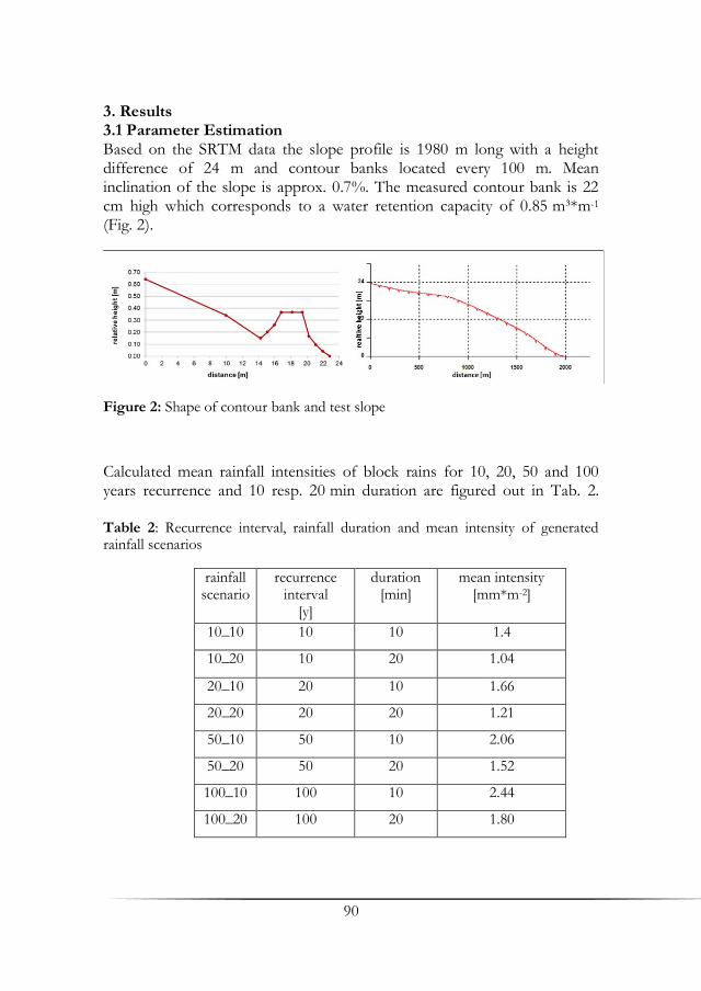
90
3. Results 3.1 Parameter Estimation Based on the SRTM data the slope profile is 1980 m long with a height difference of 24 m and contour banks located every 100 m. Mean inclination of the slope is approx. 0.7%. The measured contour bank is 22 cm high which corresponds to a water retention capacity of 0.85 m³*m-1 (Fig. 2).
Figure 2: Shape of contour bank and test slope
Calculated mean rainfall intensities of block rains for 10, 20, 50 and 100 years recurrence and 10 resp. 20 min duration are figured out in Tab. 2. Table 2: Recurrence interval, rainfall duration and mean intensity of generated rainfall scenarios
rainfall scenario
recurrence interval
[y]
duration [min]
mean intensity [mm*m-2]
10_10 10 10 1.4
10_20 10 20 1.04
20_10 20 10 1.66
20_20 20 20 1.21
50_10 50 10 2.06
50_20 50 20 1.52
100_10 100 10 2.44
100_20 100 20 1.80
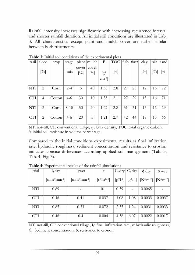
91
Rainfall intensity increases significantly with increasing recurrence interval and shorter rainfall duration. All initial soil conditions are illustrated in Tab. 3. All characteristics except plant and mulch cover are rather similar between both treatments. Table 3: Initial soil conditions of the experimental plots
trail slope
[%]
crop stage
leafs
plant
cover
[%]
mulch
cover
[%]
Ρ
[g*
cm-3]
TOC
[%]
θdry
θwet
clay
[%]
silt
[%]
sand
[%]
NT1 2 Corn 2-4 5 40 1.38 2.8 27 28 12 16 72
CT1 4 Cotton 4-6 30 10 1.35 2.1 27 29 13 16 71
NT1 2 Corn 8-10 50 20 1.27 2.8 31 31 15 16 69
CT1 2 Cotton 4-6 20 5 1.21 2.7 42 44 19 15 66
NT: not-till, CT: conventional tillage, ρ : bulk density, TOC: total organic carbon, θ: initial soil moisture in volume percentage
Compared to the initial conditions experimental results as final infiltration rate, hydraulic roughness, sediment concentration and resistance to erosion indicates concise differences according applied soil management (Tab. 3, Tab. 4, Fig. 3).
Table 4: Experimental results of the rainfall simulations
trial If dry
[mm*min-1]
If wet
[mm*min-1]
n
[s*m1/3]
Cs dry
[g*l-1]
Cs dry
[g*l-1]
ϕ dry
[N*m-2]
ϕ wet
[N*m-2]
NT1 0.89 - 0.1 0.39 - 0.0065 -
CT1 0.46 0.41 0.037 1.08 1.08 0.0033 0.0037
NT1 0.85 0.33 0.072 2.35 1.24 0.0031 0.0033
CT1 0.46 0.4 0.004 4.38 6.07 0.0022 0.0017
NT: not-till, CT: conventional tillage, If: final infiltration rate, n: hydraulic roughness,
Cs: Sediment concentration, ϕ: resistance to erosion

92
Figure 3: Infiltration rates of “dry” and “wet” runs
Based on experimental results model parameter concerning scenario simulations can be derived (Tab. 5).
93
Table 5: Estimated model parameters for scenario simulations
scenario cover
%
TOC
%
ρ
g*
cm3
θ
Vol.
-%
n
s*
m-3
Φ
N*
m-2
clay
%
silt
%
sand
%
NT_4l_d 45 2.8 1.3 29 0.049 0.0043 15 16 69
NT_4l_w 45 2.8 1.3 34 0.049 0.0043 15 16 69
NT_10l_d 70 2.8 1.3 29 0.049 0.0043 15 16 69
NT_10l_w 70 2.8 1.3 34 0.049 0.0043 15 16 69
CT_4l_d 20 2.4 1.3 29 0.021 0.0024 15 16 69
CT_4l_w 20 2.4 1.3 34 0.021 0.0024 15 16 69
CT_10l_d 35 2.4 1.3 29 0.021 0.0024 15 16 69
CT_10l_w 35 2.4 1.3 34 0.021 0.0024 15 16 69
NT: not-till, CT: conservation tillage, l: leafs, d: dry conditions, w: wet conditions, TOC: total organic carbon, ρ: bulk density, θ: initial soil moisture, n: hydraulic
roughness, ϕ: resistance to erosion
3.2 Simulation Results Model outputs regarding surface runoff and sediment yield are represented spatial distributed on slope scale (Fig. 4).
Simulation results concerning surface runoff [Q] and sediment yield [SY] are summarized in Tab. 6a und Tab. 6b. Based on model results discharges and sediment yields ranges between 0 and 38.215 m³*m-1 resp. 12106 kg*ha-1. Generally discharges and sediment yield rise with increasing recurrence interval and rainfall duration equally from “dry” to “wet” conditions and from conservation tillage to conventional tillage. Contour banks significantly reduce discharges and sediment yields. Effects of plant development are negligible.
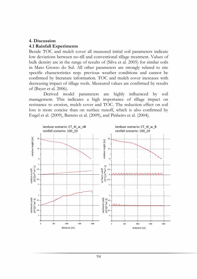
94
4. Discussion 4.1 Rainfall Experiments Beside TOC and mulch cover all measured initial soil parameters indicate low deviations between no-till and conventional tillage treatment. Values of bulk density are in the range of results of (Silva et al. 2005) for similar soils in Mato Grosso do Sul. All other parameters are strongly related to site specific characteristics resp. previous weather conditions and cannot be confirmed by literature information. TOC and mulch cover increases with decreasing impact of tillage tools. Measured values are confirmed by results of (Bayer et al. 2006).
Derived model parameters are highly influenced by soil management. This indicates a high importance of tillage impact on resistance to erosion, mulch cover and TOC. The reduction effect on soil loss is more concise than on surface runoff, which is also confirmed by Engel et al. (2009), Barreto et al. (2009), and Pinheiro et al. (2004).

95
Figure 4: Surface runoff and sediment yield on slope scale for conventional tillage, 4 leaf stage, wet conditions, without contour banks (left) with contour banks (right) regarding the 100 years event and a 20 min rainfall duration
Table 6a: Results of scenario simulations
Scenario
10 y in 10 min
10 y in 20 min
20 y in 10 min
20 y in 20 min
Q
SY
Q
[m³*
m-1]
SY
[kg*h
a-1]
Q
[m³*
m-1]
SY
[kg*
ha-1]
Q
[m³*
m-1]
SY
[kg*
ha-1]
NT_4l_d_nB - - - - - - - -
NT_4l_w_nB - - 0.843 22 2.113 105 3.55 150
CT_4l_d_nB - - 0.096 3 1.082 115 1.713 157
CT_4l_w_nB - - 11.769 1887 11.697 2875 17.607 3457
NT_4l_d_B - - - - - - - -
NT_4l_w_B - - 0.033 - 0.082 - 0.138 1
CT_4l_d_B - - 0.003 - 0.042 - 0.067 -
CT_4l_w_B - - 0.458 12 0.455 16 1.945 382
NT_10l_d_nB - - - - - - - -
NT_10l_w_nB - - 0.843 22 2.113 105 3.55 150
CT_10l_d_nB - - 0.096 3 1.082 115 1.713 157
CT_10l_w_nN_nB - - 11.769 1887 11.697 2874 17.607 3457
NT_10l_d_B - - - - - - - -
NT_10l_w_B - - 0.033 - 0.082 - 0.138 1
CT_10l_d_B - - 0.003 - 0.042 - 0.067 -
CT_10l_w_B - - 0.458 12 0.455 16 1.945 382
y: years of occurrence interval, NT: not-till, CT: conventional tillage, l: leafs, d: dry conditions, w: wet conditions, B: banks, nB: no banks, bold: overtapping of contour banks
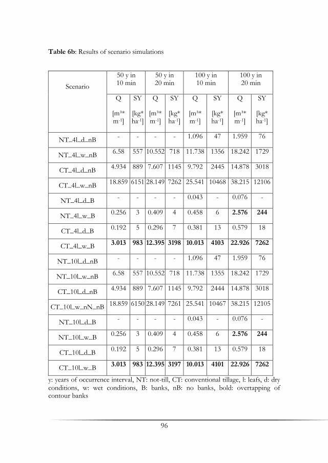
96
Table 6b: Results of scenario simulations
Scenario
50 y in 10 min
50 y in 20 min
100 y in 10 min
100 y in 20 min
Q
[m³* m-1]
SY
[kg* ha-1]
Q
[m³* m-1]
SY
[kg* ha-1]
Q
[m³* m-1]
SY
[kg* ha-1]
Q
[m³* m-1]
SY
[kg* ha-1]
NT_4l_d_nB - - - - 1.096 47 1.959 76
NT_4l_w_nB 6.58 557 10.552 718 11.738 1356 18.242 1729
CT_4l_d_nB 4.934 889 7.607 1145 9.792 2445 14.878 3018
CT_4l_w_nB 18.859 6151 28.149 7262 25.541 10468 38.215 12106
NT_4l_d_B - - - - 0.043 - 0.076 -
NT_4l_w_B 0.256 3 0.409 4 0.458 6 2.576 244
CT_4l_d_B 0.192 5 0.296 7 0.381 13 0.579 18
CT_4l_w_B 3.013 983 12.395 3198 10.013 4103 22.926 7262
NT_10l_d_nB - - - - 1.096 47 1.959 76
NT_10l_w_nB 6.58 557 10.552 718 11.738 1355 18.242 1729
CT_10l_d_nB 4.934 889 7.607 1145 9.792 2444 14.878 3018
CT_10l_w_nN_nB 18.859 6150 28.149 7261 25.541 10467 38.215 12105
NT_10l_d_B - - - - 0.043 - 0.076 -
NT_10l_w_B 0.256 3 0.409 4 0.458 6 2.576 244
CT_10l_d_B 0.192 5 0.296 7 0.381 13 0.579 18
CT_10l_w_B 3.013 983 12.395 3197 10.013 4101 22.926 7262
y: years of occurrence interval, NT: not-till, CT: conventional tillage, l: leafs, d: dry conditions, w: wet conditions, B: banks, nB: no banks, bold: overtapping of contour banks

97
Furthermore previous rainfall events simulated in “wet” runs accelerating runoff formation and accordingly soil erosion. Soil sealing is a possible explanation of this behavior. Additional a leveled soil surface by previous runoff experiment decreases ponding processes in small surface depressions, which is particular crucial on the low slopes of the study area.
4.2 Scenario Simulations Based on model simulations generally low to medium discharges and sediment yields are estimated for the test slope. Protection effect of no-till measures and contour banks decreases with increasing recurrence interval and duration of rainfall event caused by proportional higher surface runoffs.
Previous rainfall events simulated with “wet” conditions crucial increase runoff by 10 times for NT resp. 5 times for CT and sediment yields on average by 25 times for NT and 8 times for CT which is caused by soil sealing. No-till reduces runoff on average to 21% and sediment yield to only 5 % compared to conventional tillage due to the effect of higher mulch cover and higher TOC on particle detachment and infiltration.
Contour banks significantly reduce runoff and sediment yield for both NT and CT. Banks are only overflowed for NT “wet” by the 100 years event and 20 min rainfall duration with runoff and sediment yield of only 14 % of the scenario without banks.
In case of CT banks protect the slope on average 14.6% for runoff and 12.5% (100%= without banks) for sediment yield. In CT “wet” scenario overtopping occur with events exceeding the 20_10 scenario. In this context protection effect of this banks decreases with increasing rainfall amount due to higher proportional discharges. But even for the 100_20 scenario protection effect of the banks is around 60% for runoff (100%= 38215 m³*m-1) and sediment yield (100 %= 12106 kg*ha-1).
Concerning the plant development stages no significant influences on sediment yield can be asserted, which leads to the conclusion that hydraulic roughness affected by mulch cover is one of the key parameter in controlling sediment yields particularly on low erodible pseudo-sandy soils. In this context issue of mulch failure due to previous runoff events as mentioned by (Barbosa et al. 2010) become more important.
Concerning the statistically generated rainfall events it has to be assumed, that soil losses can be more severe. Natural heavy rains with distinguishing high peaks of rainfall intensity might cause higher infiltration exceeding surface runoff and higher particle detachment compared to block rains.
Furthermore it has to be considered, that overtopping of banks might occur before the estimated retention volume of 0.85 m³*m-1 is

98
exceeded especially in depressions caused by tram lanes of heavy machinery. Under such circumstances sheet flow is converted into concentrated flow causing rill or even gully erosion with spatially high detachment rates (Landers 2001).
5. Conclusion No-till measures and contour banks are suitable tools for runoff and erosion prevention on agricultural land of the Mato Grosso state in Brazil. The present study constitutes protection effects of both measures based on artificial field rainfall simulations and EROSION 2D model applications. Experimental results confirm present knowledge of high runoff and erosion protection potential by no-till measures mainly caused by increased resistances to erosion and hydraulic roughness due to high mulch cover. Although protection by no-till measures is sufficient for most rainfall events maintenance of existing contour banks will provide additional protection. Based on model simulation the authors strictly demand a construction of new or maintenance of remaining contour banks for conventional tillage measures. Without these banks, water, soil and nutrient losses cannot be efficiently prevented.
References Amorim, R. S. S., da Silva, D. D., Pruski, F. F., de Matos, A. T. (2001): Influência
da declividade do solo e da energia cinética de chuvas simuladas no processo de erosão entre sulcos. Revista Brasileira de Engenharia Agrícola e Ambiental. 5(1): 124–130.
Arvor, D., Meirelles, M., Dubreuil, V., Bégué, A., Shimabukuro, Y. (2012): Analyzing the agricultural transition in Mato Grosso, Brazil, using satellite-derived indices. Applied Geography 32(2): 702–713.
Barbosa, F. T., Bertol, I., Vieira, I. (2010): Proporção e tamanho de sedimentos e teor de carbono orgânico na enxurrada e no solo para dois cultivos e duas formas de semeadura. R. Bras. Ci. Solo 34: 1701–1710.
Barreto, R. C., Madari, B. E., Maddock, J. E. L., Machado, P. L. O. A., Torres, E., Franchini, J., Costa, A. R. (2009): The impact of soil management on aggregation, carbon stabilization and carbon loss as CO2 in the surface layer of a Rhodic Ferralsol in Southern Brazil. Agriculture, Ecosystems & Environment 132(3–4): 243–251.
Bayer, C., Martin-Neto, L., Mielniczuk, J., Pavinato, A., Dieckow, J. (2006): Carbon sequestration in two Brazilian Cerrado soils under no-till. Soil & Tillage Research 86: 237–245.
da Silva, C. G., Sobrinho, T. A., Vitorino, A. C. T., de Carvalho, D. F. (2005): Atributos físicos, químicos e erosão entressulcos sob chuva simulada, em

99
sistemas de plantio direto e convencional. Eng. Agríc. Jaboticabal. 25: 144–153.
Engel, F. L., Bertol, I., Ritter, S. R., Paz González, A., Paz-Ferreiro, J., Vidal Vázquez, E. (2009): Soil erosion under simulated rainfall in relation to phenological stages of soybeans and tillage methods in Lages, SC, Brazil. Contains papers from HighLand 2006: Land Degradation and Soil and Water Conservation in Tropical Highlands, Mekelle, Ethiopia, 21-25 September 2006. Vol. 103(2): 216–221.
Favis-Mortlock, D. T., Guerra, A. J. T. (1997): The implications of general circulation model estimates of rainfall for future erosion: a case study from Brazil. CATENA 37: 329–354.
Garcia, S. S., Amorim, R. S. S., Couto, E. G., Stopa, W. H. (2011): Determinação da equação intensidade-duração-frequência para três estações meteorológicas do Estado de Mato Grosso. Agriambi. 15: 575–581.
Landers, J. N. (2001): How and Why the Brazilian Zero Tillage Explosion Occurred. 10th International Soil Conservation Organization Meeting, p. 29–39.
Landers, J. N. (2007): Tropical crop–livestock systems in conservation agriculture. The Brazilian experience. Integrated Crop Management (5).
Leite, M., Siqueira, H., Couto, E. G., Amorim, R. S. S., da Costa, E. L., Maraschin, L. (2009): Perdas de solo e nutrientes num latossolo vermelho-amarelo ácrico típico, com diferentes sistemas de preparo e sob chuva natural. R. Bras. Ci. Solo 33: 689–699.
Pinheiro, E. F. M., Pereira, M. G., Anjos, L. H. C. (2004): Aggregate distribution and soil organic matter under different tillage systems for vegetable crops in a Red Latosol from Brazil. Contains papers from HighLand 2006: Land Degradation and Soil and Water Conservation in Tropical Highlands, Mekelle, Ethiopia, 21-25 September 2006. Vol. 77(1): 79–84.
Schmidt, J. (1996): Entwicklung und Anwendung eines physikalisch begründeten Simulationsmodells für die Erosion geneigter, landwirtschaftlicher Nutzflächen. Berliner Geographische Abhandlungen 61. Berlin.
Silva, J. F., Farinas, M. R., Felfili, J. M., Klink, C. A. (2006): Spatial heterogeneity, land use and conservation in the cerrado region of Brazil. Journal of Biogeography 33: 536–548.
Wischmeier, W. H., Smith, H. D. (1978): Predicting rainfall erosion losses- A guide to conservation planning. Washington: U.S. Dep. of Agriculture, Handbook No. 537.
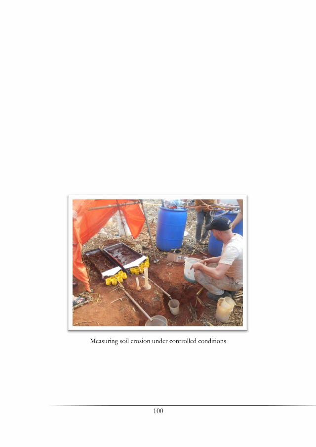
100
Measuring soil erosion under controlled conditions

101
Amazon Regional Center (INPE/CRA) Actions
for Brazilian Amazon Forest: TerraClass and Capacity Building Projects
Alessandra R. Gomes1, César G. Diniz1 & Cláudio A. Almeida2 1National Institute for Space Research, Amazon Regional Center, Belém/PA 2National Institute for Space Research, Earth Observation Division, São José dos Campos, São Paulo
Summary The aim of this paper is to present the Amazon Regional Center activities based on the Institute missions. Most of the mapping and monitoring projects from Amazon Program are fully developed on the center. In this article two projects will be described: mapping and monitoring land use and land cover areas (TerraClass) and capacity building, for knowledge transference based on INPE’s experience on tropical forest monitoring. TerraClass aims to qualify based on satellite images, already deforested areas of the Amazon with biannual frequency. It evaluates the dynamic of land use land cover comparing the changes between the years of 2008 and 2010. The project is developed in partnership with Embrapa Oriental Amazon (CPATU) and Embrapa Information and Agriculture (CNPTIA). Aiming to be considered an international center of orbital technology diffusion on tropical forests monitoring, CRA conducts international training courses, periodically held and counting with specialized infrastructure and a wide number of qualified consultants that minister theoretical and practical classes in four different languages during the courses. Key words: Amazon, Amazon Regional Center (CRA), TerraClass project, Capacity building project
102
1. Introduction The Amazon region covers 40% of the South American continent and 5% of the terrestrial surface (de Freitas 2002), besides concentrating 20% of available fresh water in the world and to be considered the largest gene bank of the planet (Silva 1999). In Brazil, the area of the Amazon Biome comprises 5 million square kilometers. With these characteristics, the Amazon demands further biodiversity studies, especially on preserved areas. However, by having a large area not yet anthropized, the pressure for occupancy is intense and becomes one of the biggest problems faced by governments that accept the challenge of minimizing the environmental damage caused by disorganized and illegal exploitation. One way to contribute on public policies definitions to combat forest exploitation is to conduct systematic forest mapping and monitoring as an attempt to reduce deforestation and assist in the space organization. To combat the advance of deforestation, remote sensing techniques have been a very efficient way to detect and quantify the degraded forest areas, and by this very reason, remote sensing remains one of the best alternatives for mapping and monitoring of tropical forest. In this scenario, Brazil is the only country in the tropical region that has a program for systematical tropical forest monitoring, which is being conducted by INPE in 1988.
Currently, the Amazon Program has 5 projects (INPE 2008, Coutinho et. al 2013): Deforestation Monitoring Project (PRODES); Near Real Time Deforestation Detection Project (DETER), Degradation Areas Detection Project (DEGRAD); Selective Logging Detection Project (DETEX) and Land Use and Land Cover Mapping on Deforested Areas (TerraClass). A brief description of the projects, satellites used, resolutions and type of deforestation mapped can be viewed on Tab. 1.
Located in Belem municipality, Para State, the Amazon Regional Center (CRA) is one of the regional centers established by the National Institute for Space Research (INPE) on the Amazon region. Among the competences of Amazon Regional Centre present in Act 897 of December 3rd, 2008 are: "Article 23 - The Regional Centre shall: [...] IV - spread geotechnology on its region; V - be an international center of orbital technology diffusion on tropical forests monitoring [...]. "
Therefore, the aim of this paper is to present the Amazon Regional Center activities based on the Institute missions. Most of the mapping and monitoring projects from Amazon Program are fully developed on the center, an important status that shows what the Center is doing towards this direction. In this article two projects will be described: mapping and monitoring land use and land cover areas (TerraClass) and capacity building, for knowledge transference based on INPE’s experience on
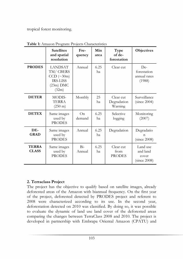
103
tropical forest monitoring.
Table 1: Amazon Program: Projects Characteristics
Satellites and spatial resolution
Fre-quency
Min area
Type of de-
forestation
Objectives
PRODES LANDSAT TM/ CBERS CCD (~30m)
IRS-LISS (23m) DMC
(32m)
Annual 6.25 ha
Clear cut De-forestation annual rates
(1988)
DETER MODIS-TERRA (250 m)
Monthly 25 ha
Clear cut Degradation
Warning
Surveillance (since 2004)
DETEX Same images used by
PRODES
On demand
6.25 ha
Selective logging
Monitoring (2007)
DE-GRAD
Same images used by
PRODES
Annual 6.25 ha
Degradation Degradation
(since 2008)
TERRA CLASS
Same images used by
PRODES
Bi-Annual
6.25 ha
Clear cut from
PRODES
Land use and land
cover (since 2008)
2. Terraclass Project The project has the objective to qualify based on satellite images, already deforested areas of the Amazon with biannual frequency. On the first year of the project, deforested detected by PRODES project and referent to 2008 were characterized according to its use. In the second year, deforestation detected on 2010 was classified. By doing so, it was possible to evaluate the dynamic of land use land cover of the deforested areas comparing the changes between TerraClass 2008 and 2010. The project is developed in partnership with Embrapa Oriental Amazon (CPATU) and
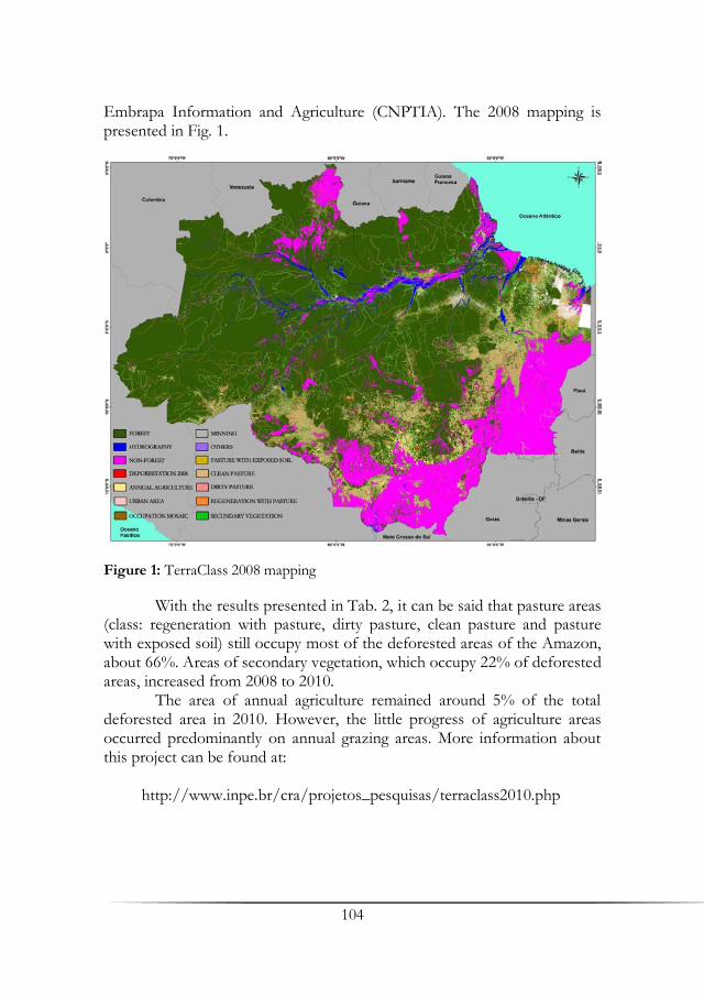
104
Embrapa Information and Agriculture (CNPTIA). The 2008 mapping is presented in Fig. 1.
Figure 1: TerraClass 2008 mapping
With the results presented in Tab. 2, it can be said that pasture areas (class: regeneration with pasture, dirty pasture, clean pasture and pasture with exposed soil) still occupy most of the deforested areas of the Amazon, about 66%. Areas of secondary vegetation, which occupy 22% of deforested areas, increased from 2008 to 2010.
The area of annual agriculture remained around 5% of the total deforested area in 2010. However, the little progress of agriculture areas occurred predominantly on annual grazing areas. More information about this project can be found at: http://www.inpe.br/cra/projetos_pesquisas/terraclass2010.php

105
Table 2: Terraclass 2008 and 2010 statistics
2008 2010 2008 2010
Classes Total (km2)
Total (km2)
(%) (%) (%)
Second vegetation 150.815,31 165.229,31 21,26 22,27 9,56
Regeneration with pasture 48.027,37 63.165,46 6,77 8,52 31,52
Pasture with exposed soil 594,19 373,16 0,08 0,05 -37,20
Clean pasture 335.714,95 339.851,87 47,32 45,82 1,23
Dirty pasture 62.823,76 56.076,64 8,85 7,56 -10,74
Forestry 0,00 3.014,79 0,00 0,41
Mosaic of land uses 24.416,57 17.962,95 3,44 2,42 -26,43
Annual Agriculture 34.927,24 39.977,85 4,92 5,39 14,46
Urban Area 3.818,14 4.473,56 0,54 0,60 17,17
Mining 730,68 966,82 0,10 0,13 32,32
Others 477,88 2.730,64 0,07 0,37 471,41
Non-observed area 45.406,27 45.849,48 6,40 6,18 0,98
Total 707.752,36 739.672,54 100 100 4,51
3. Capacity Building Project Considering the importance of the environmental issues to the international community, international organizations such as the Japan International Cooperation Agency – JICA, the Food and Agriculture Organization – FAO and also the Amazon Cooperation Treaty Organization – ACTO developed efforts to establish partnerships with INPE in order to capacitate foreign technicians to operate the TerraAmazon system, which is the system adopted by INPE to realize the specifics techniques for Amazon Program.
The training courses are held periodically at the Amazon Regional Center, located in Belem, Brazil, which has the entire infrastructure to handle the courses and also a wide number of qualified consultants that minister theoretical and practical classes during the courses. The quantity of countries already trained is presented in Fig. 2. The largest extensions of tropical forests of the world are located in South America, West Africa and Southeast Asia. In these regions there are also many countries in development, and their necessity for natural resources is threatened by intense and illegal exploration of the forests resources. Nowadays, the

106
Figure 2: Countries trained in CRA for tropical forest monitoring in black
protection of the national forests has become a priority in their agendas, as also are accompanied by the international community. The number of participants from these countries, through last 4 years-training can be viewed in Fig. 3.
Figure 3: Number of participants for each year of Capacity Building Project
Variations in the amount of years and participants reflects the
beginning and end of internationals cooperation’s, that on average are established up to 3 years of duration. In 2010, the project had only TCTP, Third Country Training Program of JICA, and the forecast of 3 international courses per year. In 2011, with the entry of FAO and ACTO partnership, the number of participants was higher, followed by 2012, where all projects were running. In 2013, with the closure of two large training

107
projects, the number of participants was lower. More information about this data: http://www.inpe.br/cra/projetos_pesquisas/capacitacao_internacional.php 4. Final Considerations The Amazon region requires studies leading to its better characterization. The systematic mapping and monitoring projects here discussed are not only contributing to better characterization of the region as it is also adding efficiency in the surveillance and combat illegal use natural resources. In this article we presented projects that settled INPE-CRA in the region and acting actively in pro of the Amazon: TerraClass and Capacity Building on tropical forest monitoring. However, there are lots other studies under development in CRA and much research to be done sharing the objective of decreasing the pressure on the Amazon rainforest and assisting other countries to do the same. References de Freitas, M. (2002): Amazonía: The Nature of the Problems and the Problems of
the Nature. International Review of Sociology – Revue Internationale de Sociologie 12: 13.
Coutinho, A. C., Almeida, C. A., Venturieri, A., Esquerdo, J. C. D. M., Silva, M. (2013): TerraClass: Uso e cobertura da terra nas áreas desflorestadas da Amazônia Legal: TerraClass 2008. Brasília.
Instituto Nacional de Pesquisas Espaciais (INPE) (2008): Monitoramento da cobertura florestal da Amazônia por satélites. Sistemas PRODES, DETER, DEGRAD e QUEIMADAS. Disponível em: http:// http://www.obt.inpe.br/prodes/Relatorio_Prodes2008.pdf> Acesso em: 04. Jul. 2013.
Silva, M. C. (1999): Metamorfoses da Amazonía, Manaus, Amazonas, Editora da Universidade do Amazonas. Manaus.

109
Land-Use Monitoring and Change Detection
Patrick Hostert, Tobia Lakes, Hannes Müller, Florian Gollnow & Leticia B. V. Hissa
Humboldt University of Berlin, Department of Geography
Summary Land use conflicts between carbon flux optimization, food production, and economic security can only be addressed if there is reliable and up-to-date information on land use available. We present new methods that allow remote sensing based land use analyses at landscape resolution with regional coverage in Mato Grosso and Pará. In Southern Pará we characterize pasture management based on Landsat time series from 1986 to 2011 to understand local land use processes and their implication for above and below ground carbon stocks. In Southern Mato Grosso we performed a land use classification for the period of 2009 to 2011, using time series derived variability metrics to separate natural savanna vegetation, cropland and pasture areas. Results of both analysis present land use processes and land use types in a novel thematic depth. The resulting LULCC data is an important basis for adapted land use management concepts including and land use change modeling to derive future scenarios.
Key words: Remote sensing, time series, land-cover, land-use, land-use modeling, ecosystem services
1. Introduction The Brazilian Amazon has been subjected to one of the world’s highest deforestation rates in the last decades. Only recently, political efforts in combination with decreasing global prices for agricultural products have led to a decrease in the rate of deforestation (Gandour et al. 2012, INPE 2011). However, land use change continues to have dramatic impacts on the environment, the society and the economy (Foley et al. 2007, Tallis & Polaski 2009, Saatchi et al 2007). Land use conflicts between carbon flux optimization, food production, and economic security can only be addressed if there is reliable and up-to-date information on land use
110
available (Gibbs et al. 2007). To overcome existing challenges in land management practices, development paths have to be identified to gather improved knowledge for likely future land use scenarios. Remote sensing analyses and land use modeling provide such input consistently, in a spatio-temporally explicit way, and across scales.
So far, the majority of remote sensing studies in Brazil focus on the legal Amazon biome including governmental programs like the annual deforestation monitoring in the legal Amazon (PRODES), the real time monitoring system for detection of deforestation (DETER) and the program for land use classification of deforested areas (TerraClass) (INPE 2008). While these sophisticated datasets provide valuable insights into deforestation processes and land use regimes, they do not have the temporal and thematic depth necessary to assess land-use change to target ecosystem services and land use-change modeling as proposed within the framework of Carbiocial.
The recent opening of the Landsat data archive permits for the first time the exploration of dense imagery time series with high spatial resolution covering large areas dating back to the 1980’s. This offers the chance to focus on land use and land cover change (LULCC) related processes and stakeholder decisions that manifest on the landscape level and at the same time, to guarantee the large spatial coverage of the extended region of Southern Pará.
We here present new methods that allow remote sensing data analyses at landscape resolution with regional coverage in Southern Pará and Southern Mato Grosso. The focus is on the optimization of classification approaches for deriving recent land use types and analyzing LULCC processes over the last 25 years based on Landsat data. The resulting LULCC data is an important basis for adapted land use management concepts and land use change modeling to derive future scenarios.
2. Methods Classification of land use types and analysis of land use processes are two different objectives requiring different methodological concepts. In the following these concepts are presented in the context of different case studies: a land cover classification of the Rio das Mortes watershed, and a case study in Novo Progresso on pasture management regimes (Fig. 1).
The Rio das Mortes watershed is located in a savanna landscape within the Cerrado biome of Southern Mato Grosso and has undergone significant land use and land cover change (LULCC) since the 1970s. It is now the major agricultural production center of Mato Grosso.

111
Figure 1: Study site A – Rio das Mortes watershed, study site B – tropical rainforest in the municipality of Novo Progresso
The Novo Progresso region is located in Southern Pará and represents one of the hot spot areas for deforestation since 1996. In contrast to the Rio das Mortes watershed, cattle farming is the dominant land use there. 2.1 Landscape Scale Image Classification of Current LULC Cropland, savanna and pasture areas have strong seasonal characteristics (Fig. 2). We here aim on optimizing the separation of cropland, pasture, natural savanna vegetation and gallery forest based on Landsat-derived variability metrics in a heterogeneous savanna landscape. We calculated six variability metrics based on a temporal window from 2009 and 2011:
mean value of each pixel for all included bands (Landsat TM/ETM+ bands 1, 2, 3, 4, 5 and 7)
median of each pixel for all included bands
standard deviation of each pixel for all included bands
75% quantile of each pixel for all included bands
interquartile range (25% - 75%) of each pixel for all included bands
Sum of SWIR/NIR bands normalized over the number of clear observations

112
Figure 2: Schematic NDVI time series of a double cropping system, pasture area and cerrado vegetation. b) Mean and standard deviation of NDVI values for the time series. Combination of NDVI mean value and standard deviation allows separating between savanna, cropland and pasture area
The temporal window was chosen to receive the maximum number of
cloud free observations in regard to a relatively low number of LULC conversions and resulted in 344 Landsat images used for analysis (Tab. 1). These images were atmospherically corrected using the Landsat Ecosystem Disturbance Adaptive Processing System (LEDAPS) developed by Masek et al. (2006). Clouds and cloud shadows were filtered employing FMask version 2.1 (Zhu and Woodcock 2012). For the final LULC mapping we used a random forest (RF) classifier, calibrated by 626 training points (Breiman 2001). Table 1: WRS2 Footprints and number of scenes
WRS2 path
WRS2 row
number of scenes
225 070 81 225 071 89 226 070 87 226 071 87
total: 344

113
2.2 Time Series Analyses to Derive Management Regimes on Pasture Areas The land use expansion frontier in Southern Pará is dominated by deforestation followed by pasture establishment. Mapping intensive, extensive and abandoned pastures areas is important to estimate above and below ground carbon stocks in this region. We analyzed yearly level 1 terrain corrected Landsat imagery from 1984 to 2011 to detect deforestation and to characterize land use regimes. The Brazilian land use classification TerraClass was employed to derive meaningful thresholds separating forest, non-forest, secondary forest and intensively and extensively managed pasture areas (Fig. 3). All analyses were based on Tasseled Cap wetness values which show a strong correlation with vegetation coverage (Crist and Cicone 1984).
Land use history of each pixel was summarized by counting the number of years in the three different land use management types (intensive pasture, extensive pasture, regrowth). This allows identifying the dominant management type, which has important implication on the carbon balance in the study region.
3. Results 3.1 LULC Classification of Rio das Mortes Watershed The LULC- classification achieved an area adjusted overall accuracy of 93% (Fig. 4). Highest reliability was observed for the forest, savanna and water classes, which revealed user`s and producer`s accuracies above 90%. Furthermore, no commission error was observed for the cropland class and 6% omission error for the pasture class. 3.2 Pasture Management in Novo Progresso Most deforestation in the region of Novo Progresso occurred during the last 15 years followed by extensive pasture management (Fig. 5a), indicating constant vegetation cover and carbon input into the soil. Pasture areas dominated by forest regrowth cover 5.5% of deforested area, pointing out constant accumulation of above and below ground carbon. Intensively managed pastures cover ca. 30% of deforestation area but their proportion is decreasing since 2001 (Fig 5b). Results on pasture age and pasture management can be used to upscale in situ measurements of soil Carbon stocks.
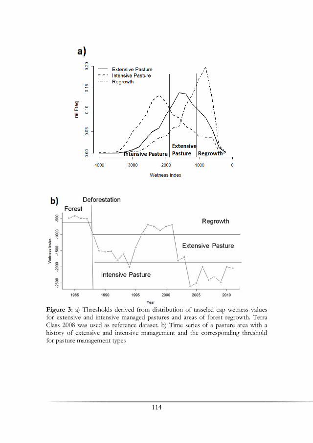
114
Figure 3: a) Thresholds derived from distribution of tasseled cap wetness values for extensive and intensive managed pastures and areas of forest regrowth. Terra Class 2008 was used as reference dataset. b) Time series of a pasture area with a history of extensive and intensive management and the corresponding threshold for pasture management types

115
Figure 4: Classification results of the Rio das Mortes watershed based on Landsat time series
4. Discussion 4.1 Benefits and Challenges of New Monitoring Techniques We presented the first studies employing Landsat time series for classifying LULC types and land use processes in this thematic depth for the Brazilian Amazon. Classification results show higher accuracies than previously achieved in literature. Grecchi et al. (2013) reports an overall accuracy of 85% by aggregating forest and savanna to a natural vegetation class and omitting open soil and urban areas. Furthermore, their classification approach heavily relies on additional MODIS data and pre-existing land cover maps. Other studies exclusively employing Landsat data reach overall accuracies of above 80% only by fusing cropland and agriculture to an agro-pastoral class (Jepson 2005, Brannstrom et al. 2008).
The spatial temporal quantification of pasture management is important to understand management decisions which are directly related to carbon dynamics and the socio-economic framework (Desjardins et al. 2004). In this context the results of the land use process analysis is a first step towards an integrated understanding of the Carbiocial project aims. In a next step, we envision to combine the information of land management and in situ measured soil carbon stocks to complement previous findings in literature (Asner et al. 2004, Hohnwald et al. 2010).
In the future, the importance of time series based methods will increase in land system science, because the history of land use systems is essential to quantify carbon stocks and ecosystem services. Image availability is crucial and fully automized methods are needed to handle the envisaged amount of data, especially for mapping large areas. Prior
116
Figure 5: a) Study area subset with patterns of deforestation. The deforestation date can be directly related to pasture age. b) Management regimes in regard to respective deforestation years for the entire study region (only considering pasture areas established before 2009 to insure a minimum pasture age of 3 years)
117
knowledge of land use processes is needed to decide for the temporal scale of analysis.
4.2 Land-Use Change Data for Land-Use Change Modeling The derived land-use information provides up-to-date and comparable data across time and space. This is a decisive input for ecosystem service analyses on the one hand and for spatially explicit modeling of land use changes at the landscape scale on the other hand. The newly derived land-use data will allow us to revisit our present modeling study that focuses on deforestation, land use displacement, and land use change scenarios, which are currently limited by the available temporal and thematic depth of PRODES and TerraClass data. Differentiated land use data for the whole study area will allow us to overcome these data limitations.
References Asner, G. P., Townsend, A. R., Bustamante, M., Nardoto, G. B., Olander, L. P.
(2004): Pasture degradation in the central Amazon: linking changes in carbon and nutrient cycling with remote sensing. In: Global Change
Biology 10(5): 844‐862. Brannstrom, C., Jepson, W., Filippi, A. M, Redo, D., Xu, Z., Ganesh, S. (2008):
Land change in the Brazilian savanna (Cerrado), 1986-2002: Comparative
analysis and implications for land-use policy. Land Use Policy 25(4): 579‐595.
Breiman, L. (2001): Random forests. Machine learning 45(1): 5‐32. Crist, E. P., Cicone, R. C. (1984): A Physically-Based Transformation of Thematic
Mapper Data‐-The TM Tasseled Cap. Geoscience and Remote Sensing,
IEEE Transactions (3), p. 256‐263. Desjardins, T., Barros, E., Sarrazin, M., Girardin, C., Mariotti, A. (2004): Effects of
forest conversion to pasture on soil carbon content and dynamics in Brazilian Amazonia. Agriculture, Ecosystems & Environment 103(2):
365‐373. Foley, J. A., Asner, G. P., Costa, M. H., Coe, M. T., DeFries, R., Gibbs, H. K.,
Howard, E.A. (2007): Amazonia revealed: Forest degradation and loss of ecosystem goods and services in the Amazon Basin. Forest Ecology Environment 5: 25–32.
Grecchi, R. C., Gwyn, Q., Hugh, J., Bénié, G. B., Formaggio, A. R. (2013): Assessing the spatio-temporal rates and patterns of land-use and land-cover changes in the Cerrados of southeastern Mato Grosso, Brazil.
International Journal of Remote Sensing 34(15): 5369‐5392. Gibbs, H. K., Brown, S., Niles, J. O., Foley, J. A. (2007): Monitoring and estimating
tropical forest carbon stocks: making REDD a reality. Environmental Research Letters 2: 1–13.

118
Godar, J., Tizado, J., Pokorny, B. (2012): Who is responsible for deforestation in the Amazon? A spatially explicit analysis along the Transamazon Highway in Brazil. Forest, Ecology and Management 267: 58-73.
Hohnwald, S., Abréu, E. M. A., Krummel, T., Trautwein, J., da Veiga, J. B., Wollny, C. B. A., Braga Calandrini de Azevedo, C. M., Gerold, G. (2010): Degraded pasture distribution and woody enrichment strategies for pasture fertility preservation in the Bragantina region, north-eastern
Amazon. Erdkunde 64(1): 17‐31. INPE (Instituto Nacional de Pesquisas Espaciais) (2008):Monitoramento da
Cobertura Florestal da Amazônia por Satélites. Sistemas Prodes, Deter, Degrad E Queimadas 2007-2008. Inpe-Coordenação Geral de Observação da Terra São José Dos Campos. Available at: http://www.obt.inpe.br/prodes/Relatorio_Prodes2008.pdf, accessed on 6.09.2011.
INPE (Instituto Nacional de Pesquisas Espaciais) (2011): PRODES: Assessment of Deforestation in Brazilian Amazonia. Available at: www.obt.inpe.br/prodesdigital/
Phillips, O. L., Lewis, S. L., Baker, T. R., Chao, K. J., Higuchi, N. (2008): The changing Amazon forest. Philosophical Transactions of the Royal Society B 363: 1819–27.
Jepson, W. (2005): A disappearing biome? Reconsidering land-cover change in the
Brazilian savanna. In: The Geographical Journal 171 (2): 99‐111. Masek, J. G., Vermote, E. F., Saleous, N. E., Wolfe, R., Hall, F. G., Huemmrich, K.
F., Gao, F., Kutler, J., Lim, T. K. (2006): A Landsat surface reflectance dataset for North America, 1990-2000. Geoscience and Remote Sensing
Letters, IEEE 3 (1), p. 68‐72. Saatchi, S. S., Houghton, R. A., Alvala, R. J., Soares, V., Yu, Y. (2007): Distribution
of aboveground live biomass in the Amazon basin. Global Change Biology 13: 816–37.
Tallis, H., Polasky, S. (2009): Mapping and valuing ecosystem services as an approach for conservation and natural-resource management. The Year in Ecology and Conservation Biology 1162: 265-283.
Zhu, Z., Woodcock, C. E. (2012): Object-based cloud and cloud shadow detection
in Landsat imagery. Remote Sensing of Environment 118: 83‐94.
119
Development and Implementation of a Hierarchical
Model Chain for Modelling Regional Climate Variability
and Climate Change over Southern Amazonia
Jürgen Böhner1, Helge Dietrich1, Klaus Fraedrich3,
Tobias Kawohl1, Markus Kilian2, Valerio Lucarini2 &
Frank Lunkeit2
1Institute of Geography, University of Hamburg 2Meteorological Institute, University of Hamburg 3Max Planck Institute for Meteorology, Hamburg
Summary A hierarchical model chain for Southern Amazonia is introduced consisting of a dynamical and a statistical downscaling approach. In addition, a statistical method to generate climate projections is applied to the target region. Results of present day climate indicate significant impact of local boundary properties like topography on the spatial variability of climate variables such as precipitation. Preliminary results for potential future climate change show distinct signals in the energy and water budget. Key words: Climate variability, climate change, regional climate modelling, statistical-dynamical downscaling, climate regionalization, future climate
1. Introduction In the tropics of South America, Global Climate Change will undoubtedly affect both, the natural dynamics of highly vulnerable forest ecosystems and the future framework conditions for agricultural crop production (Climate Change 2007). The resulting need for a timely assessment of critical implications for the potential future state of environmental resources, goods and services in this climate-sensitive region, however, is thwarted by the lack of spatial high-resolution climate modelling studies. To date, most climate model based experiments and sensitivity studies were undertaken to analyse the effects of Amazon deforestation for the climate system and thus cover

120
broad domains in a rather coarse resolution (Avissar & Nobre 2002; Avissar et al. 2002; Betts & Jakob 2002; Lawton et al. 2001; Lean & Rowentree 1997; Werth & Avissar 2002; Zhang et al. 2001). Although outcomes approve the significant climate forcing role of land use/land cover change, results reveal distinct uncertainties particularly in modelling rainfall and moreover, the horizontal model discretization (i.e. grid spacing) down to 0.5 degrees latitude-longitude is still to coarse, to support local- to regional scale environmental modelling studies and climate impact analyses as foreseen in Carbiocial. On the other hand spatial high resolution climate layers like the WorldClim data sets (Hijmans et al. 2005), used in numerous environmental studies, provide rather static climate information (long term monthly means) and thus limit the methodical opportunities for climate impact analyses to purely empirical analogues. Further constrains for climate research concern the scarcity of temporally high resolution (e.g. daily) climate information given the relatively low amount of available network observations from Southern Amazonia, not appropriate to distinguish between natural and anthropogenic forcing of climate variability.
In view of these limitations on the one hand, and the multiple needs on substantial data support for concrete climate and environmental protection strategies on the other, the core task of our subproject was to integrate available data resources and advanced climate modelling approaches in an overall consistent and comprehensive modelling network, capable to provide spatiotemporal high resolution climate data for both, present and future time slices. Assuming interannual and long term variations of precipitation and water budget to be major determinants for the stability, function and resilience of both managed and natural ecosystems in the target area, research particularly emphasized on a scale-crossing analysis of relationships between external atmospheric forcings, land use and vegetation cover. 2. Methods and Modelling Components Given that the complex interrelations of global, synoptic and sub-synoptic topographically determined processes are only to be represented by a suite of modelling and downscaling components, each valid for specific scales and atmospheric processes, method and model development aimed to integrate global and regional climate modelling approaches, statistical downscaling and surface parameterization methods within a comprehensive hierarchical model chain, enabling retroactive simulations (hindcast mode), short to medium range forecasts (forecast mode) and scenario simulations (scenario mode).

121
In order to analyse the multi-scale characteristics of land-atmosphere interactions, the model ensemble and methodical setup links global, mesoscale and local processes, each represented by specific components at different levels of model domains:
Lateral Boundary Conditions: Natural and anthropogenic forcings in the global climate system are represented by General Circulation Model (GCM) simulations at the top of the model chain, representing large-scale atmospheric processes and changes. Depending on the target time slice and simulation mode, the modelling components are either forced by ERA-Interim reanalysis series (hindcast mode), Global Forecast System data (forecast mode) or GCM based scenario simulations (scenario mode).
Dynamical Downscaling: Physically based numerical refinement of coarse resolution GCM data for daily resolution simulations of synoptic (mesoscale) tropospheric processes is performed, using the non-hydrostatic Regional Climate Model (RCM) Weather Research and Forecasting (WRF) (Skamarock et al. 2005). The WRF Model was implemented in a multi-nesting level modelling architecture covering model domains of different spatial extension and resolution in a one-way nesting mode.
Statistical Downscaling: Empirically based methods for the spatial refinement of GCM or RCM outputs and the regionalization of point source observations comprise of a suite of GIS-based methods for surface parameterization (especially inferred from Digital Elevation Models), model residue analyses and numerous alternative interpolation routines. Moreover, the Statistical Regional Model (STAR) (Orlowsky 2007, Dissertation, University of Hamburg) from the Potsdam Institute for Climate Impact Research (PIK) was implemented to employ bias-bootstrapped weather analogues for climate projections.
The empirical data base for validation and calibration applications comprised of available network-observations from 28 climate stations and 25 synoptic stations, acquired and bundled in a database for the purpose of regression based statistical downscaling steps, bias adjustments and of quantifying potential uncertainties of the WRF model and for STAR. Data were obtained online from the data server (GSOD) of the US-American National Climatic Data Center (NCDC), from Brazilian airports and from the "Systema Integrado de Datos ambientais" SINDA from the Brazilian ministry of science and technology.

122
3. State of Implementation and Results Climate Model Data Assimilation and Processing: Referring to the previously sketched goals, one important prerequisite for the design and development of climate modelling components was the realization of computational efficient data assimilation and processing schemes for climate model data, supporting an operational refinement and bias correction of reanalyses series, GCM and RCM simulations. Based on the System for Automated Geoscientific Analysis (SAGA), a modular organized programmable GIS developer platform (http://www.saga-gis.org), an interface for climate model data formats (i.e. NetCDF and GRIB) was realized, which enables the reading, statistical analysis, reprojection and spatial refinement of even vast climate model outputs. The model interface provides a comprehensive set of interpolation algorithms and advanced routines for the continuous (vertical and horizontal) parameterisation of modelled grid-mesh data, required to identify and define suitable tropospheric predictor variables for statistical downscaling applications so as to infer e.g. tropospheric temperature and moisture laps rates from discrete troposphere layers for altitude adjusted climate estimates.
Regionalization of Baseline Climate Data Sets: Regarding the multiple needs for climate data and modelling support at different stages of research from the Carbiocial subproject, preliminary baseline climate data sets for the time period 1981-2013, consisting of daily resolution climate variables (temperature, precipitation, humidity, wind speed) had been estimated from ERA-Interim reanalysis series on a horizontal 900 x 900m grid. Although temperatures (daily mean, maximum and minimum) had been altitude adjusted, using a Digital Elevation Model (DEM), residue analyses based on network observations reveal an underestimation of monthly mean temperatures of about 2K in the northern areas of the modelling domain (during March to August)and denote the need for slight bias corrections. Residue analyses of precipitation totals instead prove precipitation estimates inferred from ERA-interim reanalyses to be less biased at least as monthly means are considered. Further methodical opportunities, to achieve a more precise estimation of climate variables using surface parameterization techniques are currently in progress. For a comprehensive description and discussion of DEM based climate regionalization and downscaling methods see Böhner & Antonic (2008).
Dynamical Downscaling – WRF Application: In order to achieve a sufficient model representation of mesoscale tropospheric processes, the Weather Research and Forecast (WRF) model has been implemented on the DKRZ (Deutsches Klimarechenzentrum) computer architecture. A local multi domain setup for South America with special focus on the target

123
region has been defined, utilizing a one-way nesting strategy with three nesting levels of about 30x30km, 10x10km and 3.3x3.3kmfor retroactive simulations (Fig. 1). Preparing the retroactive climate simulations different forcing strategies have been tested. Short (24h) hindcast simulations with a 12h spin up time have been chosen for the final simulations forced by ERA-interim-reanalysis data. For climate projections (scenario mode), however, an additional nesting level of about 90 x 90 km needs to be implemented since the forcing data (global climate model output) are of coarser resolution.
So far, the retroactive simulations for 2001 to 2010 are completed in the coarsest resolution (first nesting level; about 30 x 30km). And, before starting the runs using the next nesting level a thorough validation has been
carried out. The results show that the WRF reproduce the mean large scale features of the forcing data set. However, there are also some differences. Small scale features can be observed in, i.e. total precipitation even when considering long averages (yearly sums), reflecting the model sensitivity to
Figure 1: WRF-model domain configuration
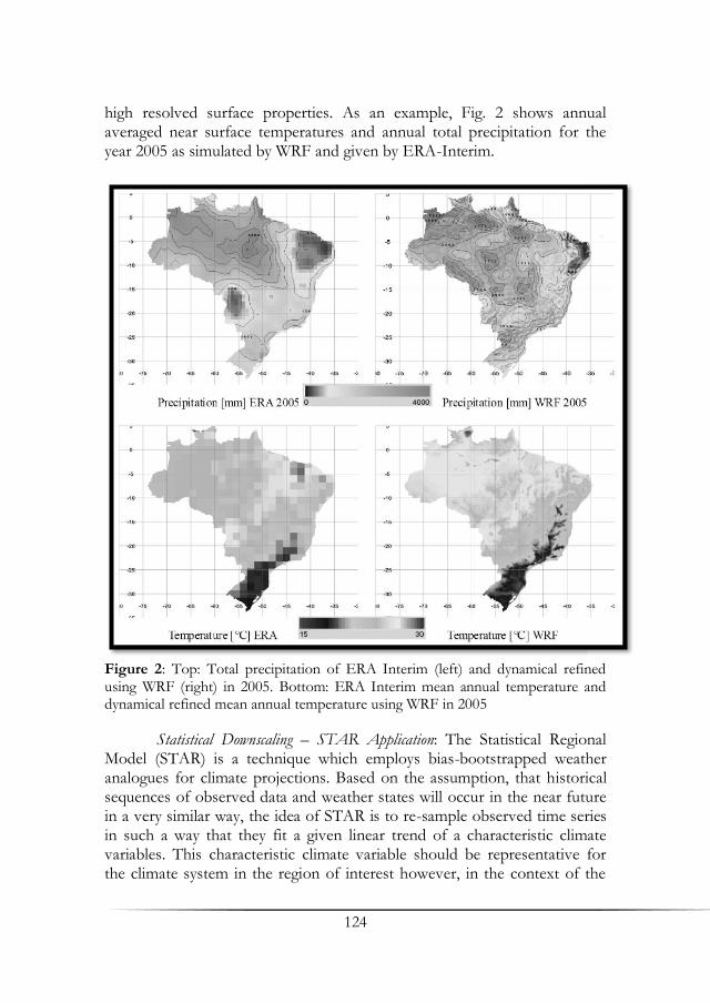
124
high resolved surface properties. As an example, Fig. 2 shows annual averaged near surface temperatures and annual total precipitation for the year 2005 as simulated by WRF and given by ERA-Interim.
Figure 2: Top: Total precipitation of ERA Interim (left) and dynamical refined using WRF (right) in 2005. Bottom: ERA Interim mean annual temperature and dynamical refined mean annual temperature using WRF in 2005
Statistical Downscaling – STAR Application: The Statistical Regional Model (STAR) is a technique which employs bias-bootstrapped weather analogues for climate projections. Based on the assumption, that historical sequences of observed data and weather states will occur in the near future in a very similar way, the idea of STAR is to re-sample observed time series in such a way that they fit a given linear trend of a characteristic climate variables. This characteristic climate variable should be representative for the climate system in the region of interest however, in the context of the

125
scientific “global warming” debate, bias-bootstrapped weather analogues are mostly inferred from temperature time series. The results of STAR applications are ensembles of simulated (i.e. recombined) climate time series on a local to regional scale for the near future, solely based on observed data (Orlowsky et al. 2010, Zhu et al 2013).
Preliminary STAR simulations, referring to the IPCC SRES A1B scenario (IPCC 2007) have been performed, using areal-average annual, monthly and daily mean values of temperatures of the target area. In a first approximation full years of temperatures have been re-sampled to fit a given temperature increase of 1.7K as simulated by the IPCC Climate Model ensembles for the A1B scenario in the time period 2011-2040. In a second step blocks of a length of 12 days are recombined to match the temperature trend more appropriate. All observed variables have been re-sampled accordingly. Fig. 3 shows the results of the projected temperature and precipitation changes for the target area, particularly revealing a distinct reduction of precipitation in the near future. Results are largely confirmed by STAR applications of Kilian (2012, Master Thesis, University of Hamburg), who simulated temperature and precipitation changes for the
Figure 3: Shading: Averages warming 1981-2010 compared to 2011-2040. Contours: Change [%] in precipitation 1981-2010 compared to 2011-2040 in the target region

126
Amazon river basin in the time period 2011-2030, forced with ECHAM6 Representative Concentration Pathways (RCP) 8.5 simulations of the fifth IPCC Assessment Report (AR5), showing likewise a significant decrease in precipitation up to 15% in the target area.
4. Discussion Global climate change and its local impact needs to be analysed and assessed in a probabilistic way under consideration of uncertainty ranges, which, so far, are only sufficiently covered by General Circulation Model (GCM) experiments and GCM forced modelling approaches (IPCC 2007, Paeth 2007). The typical spatial resolution of state-of-the-art GCM in the order of 102 to 103 km, however, remains far beyond the needs for climate impact analyses at finer scales and thus requires the realization of a suitable downscaling strategy (Hewitson & Crane 1996; Machenhauer et al. 1996; Emeis 2008). Our research aimed to tackle this challenging task by implementing both, numerical and statistical downscaling approaches, supported by SAGA GIS based regionalization routines. Although modelling results and especially WRF simulations remain biased, and, moreover, the empirical data base is clearly limited, we see no alternative to merge top down and bottom up modelling strategies as the only means, to provide spatiotemporal flexible climate information in case of limited data availability. While model results appear to be the main source to assess climate variability covering the whole area it is clear that local information can only be retrieved by statistical downscaling combining model output, in-situ measurements and local boundary information like land use parameters. Here we still see significant improvement opportunities. The WRF results show that even relatively small changes of the boundary characteristics, e.g. low terrain undulation, may lead to considerable variations of climate parameters like precipitation. Preliminary climate projections reveal distinct and biophysical relevant climate change signals in the energy and water cycle within the target region. It can be expected that these changes will have a significant impact on the local ecology and economy.
References
Avissar, R., Nobre, C. A. (2002): Preface to special issue on the Large Scale Biosphere-Atmosphere Experiment in Amazonia (LBA). Journal of Geophysical Research. Vol. 107 (D20).
Avissar, R., Silva Dias, P. L., Silva Dias, M. A. F., Nobre, C. A. (2002): The Large Scale Biosphere-Atmosphere Experiment in Amazonia (LBA): Insights

127
and future research needs. Journal of Geophysical Research. Vol. 107 (D20).
Betts, A. K., Jakob, C. (2002): Study of diurnal cycle of convective precipitation over Amazonia using a single column model. Journal of Geophysical Research. Vol. 107(D23).
Böhner, J. ,Antonic, O. (2009): Land-surface parameters specific to topo-climatology. Developments in Soil Science 33: 195-226.
Intergovernmental Panel on Climate Change (IPCC) (2007): Climate Change. Synthesis Report. Contribution of Working Groups I, II and III to the Fourth Assessment Report of the Intergovernmental Panel on Climate Change Core Writing Team. Pachauri, R. K., Reisinger, A. (eds.) IPCC, Geneva, Switzerland, 104.
Emeis, S. (2008): Examples for the determination of turbulent (sub-synoptic) fluxes with inverse methods. Meteorologische Zeitschrift 17:3-11.
Hewitson, B. C., Crane, R. G. (1996): Climate downscaling: techniques and application. Climate Research 7: 85-95.
Hijmans, R. J., Cameron, S. E., Parra, J. L., Jones, P. G., Jarvis, A. (2005): Very high resolution interpolated climate surfaces for global land areas. Int. J. Climatol. 25: 1965–1978.
Lawton, R. O., Nair, U. S., Pielke, R. A., Welch, R. M. (2001): Climatic impact of tropical lowland deforestation on nearby montane cloud forests. Science 294: 584-587.
Lean, J., Rowentree, P. R. (1997): Understanding the Sensitivity of a GCM Simulation of Amazonian Deforestation to the Specification of Vegetation and Soil Characteristics. Journal of Climate 10: 1216-1235.
Lloyd, C. (2010): Spatial Data Analysis - An Introduction for GIS Users. Oxford University Press.
Machenhauer, B., Windelband, M., Botzet, M., Jones, R. G., Déqué, M. (1996): Validation of present-day regional climate simulations over Europe: Nested LAM and variable resolution global model simulations with observed or mixed layer ocean boundary conditions. Izvestiya Akademi Nauk Fizika Atmosfery Okeana 31: 719-724.
Orlowsky, B. (2007): Setzkasten Vergangenheit- ein kombinatorischer Ansatz für regionale Klimasimulation. Ph. D. thesis, University of Hamburg.
Orlowsky, B., Bothe, O., Fraedrich, K., Gerstengarbe, F.-W., Zhu, X. (2010): Future Climates from Bias-Bootstrapped Weather Analogs: An Application to the Yangtze River Basin. J. Climate 23: 3509–3524. doi: http://dx.doi.org/10.1175/2010JCLI3271.1
Paeth, H. (2007): Human activity and Climate Change in Africa. - In: Brönnimann, S., Lauterbach, J., Ewen, T., Diaz, H. F., Stolarski, R.S., Neu, U. (eds): Climate variability and extremes during the past 100 years. Advances in Global Change Research. Vol. 33. Springer.
Skamarock, W. C., Klemp, J. B., Dudhia, J., Gill, D. O., Barker, D. M., Wang, W., Powers, J. G. (2005): A description of the Advanced Research WRF Version 2. NCAR Technical Note NCAR/TN- 468+STR, 88.

128
Werth, D., Avissar, R. (2002): The local and global effects of Amazon deforestation. Journal of Geophysical Research. Vol. 107 (D20).
Zhang, H., Henderson-Sellers, A., Mcguffie, K. (2001): The compounding effects of tropical deforestation and greenhouse warming on climate. Climate Change 49: 309-338.
Zhu, X., W. Wang, and K. Fraedrich, 2013: Future climate in the Tibetan Plateau from a statistical regional climate model. J. Climate 24, 10125-10138.

129
Intercol and Steps Towards a Simplified DSS
Claas Nendel1, Hermann Jungkunst2 & Adriano M. R. Figueiredo3
1Leibniz-Centre for Agricultural Landscape Research (ZALF), Institute of Landscape Systems Analysis, Müncheberg 2University of Koblenz-Landau, Chair of Geoecology / Physical Geography, Landau 3Federal University of Mato Grosso, Faculty of Economics, Cuiabá
Summary A product of inter-disciplinary research, a model-based decision support system prototype was created for issues of land use management, carbon cycling and climate change in Southern Amazonia. An agent-based farm economy simulation model, a process-based agro-ecosystem simulation model and a greenhouse gas production module were coupled within a spatial map-based user guidance interface to raise model-based decision support to a new level. This text shortly presents the participating models and the data put to their disposal within the software product, and discusses the challenges and constraints of the model coupling.
Key words: Decision support, model coupling, multi-disciplinarity
1. Introduction Inter-disciplinary collaboration is increasingly demanded for environmental research. This includes the multiple disciplines that cover the different bio-physical aspects of environmental systems and which are represented by conventional natural sciences. However, the additional consideration of socio-economic disciplines continuously gains importance as they add vital information and understanding on drivers, processes and boundary conditions which make up a human-influenced environmental system. Research on future development of the Southern Amazon region requires this multi-disciplinary approach across all research activities, starting with joint approaches on detailed research questions, e.g. on carbon storage in soil or greenhouse gas emissions from agriculture, and ending with the joint

130
development of a research framework, e.g. equiprobable pathways of how the Southern Amazon region may evolve in future. The almost non-existing intersection of terminology between natural and social sciences and the different approaches in system thinking turns out to be the most challenging part of multi-disciplinary research. However, finding similarities amongst disciplines and developing a common set of terms and topics sparks many exciting research actions with previously unseen results.
The Carbiocial research project comprises three groups of disciplines which interact in research. The Carbon Credit (CAC) module includes scientists of mostly geo-scientific background and aims at investigating how carbon (C) is stored in and emitted from the different sub-systems that make up the Southern Amazonia ecosystems. The Land Use Management (LUM) module includes a large share of modellers which, from different points of view and at different scales, try to explain and predict the behaviour of the Southern Amazonia ecosystems. Finally, social and political scientists overarch both modules and contribute with their knowledge on human–human and human–environment interactions to the aims of the CAC and LUM modules, and to socio-economic research questions as a module of its own.
The results of this multi-disciplinary approach will be presented in different ways. One of these will be a prototype of an interactive model-based decision support system (DSS), which was adapted from the LandCaRe DSS of Wenkel et al. (2013). This software will be used as a framework to present inter-linked simulation models in the geospatial and socio-economic context of Southern Amazonia. 2. Methods The DSS Concept and Software Framework: Decision support to develop viable climate change adaptation strategies for agriculture and regional land use management encompasses a wide range of options and issues. The model-based decision support system LandCaRe DSS (Wenkel et al., 2013) supports interactive spatial scenario simulations, multi-ensemble and multi-model simulations at the regional scale, as well as the complex impact assessment of potential land use adaptation strategies at the local scale. Via the internet, the system is connected to a climate data server and a local geo-database, which uses the Google Maps® front end for user guidance. LandCaRe DSS uses a multitude of scale-specific ecological impact models, which are linked in various ways. LandCaRe DSS offers a variety of data analysis and visualisation tools, a help system for users and a farmer information system for climate adaptation in agriculture. The main objective of LandCaRe DSS is to provide information on the complex long-term
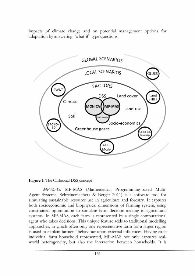
131
impacts of climate change and on potential management options for adaptation by answering “what-if” type questions.
Figure 1: The Carbiocial DSS concept
MP-MAS: MP-MAS (Mathematical Programming-based Multi-Agent Systems; Schreinemachers & Berger 2011) is a software tool for simulating sustainable resource use in agriculture and forestry. It captures both socioeconomic and biophysical dimensions of farming system, using constrained optimisation to simulate farm decision-making in agricultural systems. In MP-MAS, each farm is represented by a single computational agent who takes decisions. This unique feature adds to traditional modelling approaches, in which often only one representative farm for a larger region is used to explain farmers’ behaviour upon external influences. Having each individual farm household represented, MP-MAS not only captures real-world heterogeneity, but also the interaction between households. It is
132
applied to understand how agricultural technology, market dynamics, environmental change, and policy intervention affect a heterogeneous population of farm households and the agro-ecological resources these households command (e.g. Schreinemachers et al. 2010).
MONICA: The process-based agro-ecosystem model MONICA (Nendel et al. 2011) was designed to assess the impacts of climate and land use changes on the agricultural productivity and the environment (e.g. Nendel et al. 2013). It captures the influence of climatic factors, including atmospheric CO2 concentration, site factors and management on plant growth and soil processes and reproduces feedback regulations in agro-ecosystems. MONICA has been calibrated against field data of major agricultural crops such as cereals, sugar beet and maize, also under elevated atmospheric CO2 concentration, and tested independently at different sites across Germany (Nendel et al. 2011), Europe (Rötter et al. 2012) and other environmental zones (Asseng et al. 2013). For the use in Brazil, local crops (e.g. maize, soybean, cotton, sugar cane) have been parameterised and tested against local data sets.
A Module for Greenhouse Gas Emissions: MONICA simulates crop growth processes on the basis of carbon (C) assimilation, distribution and turn-over under decomposition. Simulated microbial processes in soil facilitate the reproduction of CO2 emission from C turn-over processes. However, the production of N2O from nitrification in soil has not been previously considered in the model. An N2O module has been implemented in the MONICA code, which describes N2O production in dependence of soil pH and the size of a virtual soil nitrite pool.
Coupling MPMAS and MONICA: The coupling between MONICA and MPMAS is bidirectional. In a first step, MPMAS generates land use and passes the data on to MONICA. MONICA then calculates yields for all crops in the data set, and plays the yields back to MP-MAS. MPMAS is then calculating farm accountancy figures (e.g. farm profit, gross margin) for the individual production practices comprising the land use data. Both models share a defined set of soil classes, for which MP-MAS holds a predefined set of default values. The coupling is implemented both at the program application interface level by exchanging data structures and at the systems level via configuration files and a shared database.
Soil and Climate Data: The soil profile data required to feed MONICA was obtained from the updated geo-referenced soil database of Brazil (Benedetti et al. 2011). Only soil profiles within the borders of Mato Grosso and Pará which contained all required information on texture and soil organic carbon were considered. If missing, the soil organic matter C to N ratio was set to 12 and C contents of the A2 horizon were set to 50% of

133
the value of A1. Bulk densities were added according to Ministéro da Agricultúra (1971) or, if not available, a bulk density of 1.4 g cm−3 (soils with clayey texture 1.2 g cm−3, clay soils 1.0 g cm−3) was used as a default. Further rules were applied to create continuous soil profiles down to a depth of 2m.
Climate data is currently processed at the University of Hamburg Institute of Meteorology, scaling climate data resulting from simulations of the ECHAM5 (Roeckner et al. 2003) global circulation model down to a 900 × 900m grid using the regional climate model WRF (Skamarock et al. 2005). Once generated, the climate date will be stored in a server facility at the University of Hamburg Institute of Geography, granting remote access to the DSS via internet. This set-up is expected to come into force in April 2014. 3. Results The current state of the DSS prototype is presented at the Carbiocial conference in Cuiabá, 8th of October 2013. Since climate data is not yet available via remote access, a reduced set of locally stored climate data is used for presentation purpose. The presentation demonstrates the various opportunities to employ the MP-MAS–MONICA tandem and illustrates how the models from different disciplines can be used jointly to supplement information on ecosystem and farmer’s behaviour to burning issues related to climate and land use change. The benefit of the multi-disciplinary model coupling becomes visible when feedback mechanisms mark through the simulation results. Environmental and socio-economic scenarios may be added to define framework conditions for the models used in the DSS, further adding to the inter- and multi-disciplinary concept. 4. Discussion Merging Models of Different Disciplines: Many simulation models for human-environmental systems are limited in their scope and in the issues they address. However, quite often one can find models that produce an output that, in turn, is required as an input for another model. Combining these models may offer opportunities of creating new insight on system behaviour or prediction uncertainty. However, there are a few preconditions that have to be accounted for before merging two models, apart from the consideration if the coupling makes sense from the conceptual point of view. First of all, the two models to be linked need to share a common concept of space and time. As soon as one of them disagrees, a coupling will be handicapped and a transition framework is needed to translate the output variable into an input variable. Linking a hydrological model at the
134
catchment scale to an infiltration model at a point scale may require grid-wise calculations of many instances of the point model to create a feasible input for the catchment model. Similarly, a daily time-step model requires an output aggregation before it can feed into a monthly time-step model. Secondly, the models need to share at least one common state variable with similar interpretation of its content and function. However, some models even share a set of common state variables and the coupling may introduce a new level of feedback relations when the coupling is implemented at multiple junctions. Thirdly, the coding of the two models needs to support the coupling. In the most comfortable case, both models are implemented in the same computer language. However, wrapping techniques using script languages may help to implement a coupling using external code to translate the linking state variable.
Challenges and Constraints of Coupling MPMAS and MONICA: At a first glance, coupling two C++ coded models seems feasible and a simple thing to do. In the simplest case, one model can be coded into another and form a new model, as it was done with the N2O module in MONICA. Together with MONICA’s ability to calculate CO2 production from soil organic matter turn-over, the N2O production module adds to the greenhouse gas emission assessment. It is only methane, which would be additionally required to complete the bundle. With MP-MAS, a completely different model philosophy enters the scene. Although both coded in C++ and interacting via only one single state variable (yield per hectare), MP-MAS and MONICA differ in vital assumptions. The most challenging of them is the fact that MONICA assumes spatially explicit sequences of crops, while MP-MAS uses distributions of single crops within a virtual area, which may change from year to year regardless of their physical location and their chronological order in typical rotations. Consequently, once an agent changes the distribution of crops in his farm, MONICA is not able to translate this change into a new crop rotation. The only solution for this problem would require a set of grid cells on which crops grow according to the agent’s decision, and MONICA follows the crop sequence in each of the cells to simulate e.g. long-term soil organic carbon dynamics or climate-induced yield trends. However, simulating a large number of grid cells consumes too much computation resources which then largely increases the user response time and thus threatens the interactive nature of the DSS. A similar problem arises from the number of agents used in MP-MAS, each of which adds significantly to the processing time. To stay within acceptable user response time, the number of possible agents to be used in DSS applications is limited.

135
In order to couple both models at all, significant simplifications and further assumptions were to be made with respect to the crop rotations and their application in space and time. However, although both models are written in C++ code and share similar theoretical approaches, their complementary features in fact cannot be leveraged due to the above-mentioned semantic incompatibilities. To do this, both models require a fundamental overhaul. Thus, the potential of having MP-MAS create economically viable land use data for a farm for one year, then having those crops grown on this farm with MONICA and finally evaluating this land use strategy and passing on the farm profits under updated simulated market conditions to calculate the following year’s land use is not possible in the current stage of MP-MAS and MONICA and will not be manageable within Carbiocial.
References Asseng, S., Ewert, F., Rosenzweig, C., Jones, J. W., Hatfield, J. L., Ruane, A, Boote,
K. J., Thorburn, P., Rötter, R. P., Cammarano, D., Brisson, N., Basso, B., Martre, P., Aggarwal, P. K., Angulo, C., Bertuzzi, P., Biernath, C., Challinor, A., Doltra, J., Gayler, S., Goldberg, R., Grant, R., Heng, L., Hooker, J., Hunt, T., Ingwersen, J., Izaurralde, C., Kersebaum, K. C., Müller, C., Naresh Kumar, S., Nendel, C., O’Leary, G., Olesen, J. E., Osborne, T. M., Palosuo, T., Priesack, E., Ripoche, D., Semenov, M., Shcherbak, I., Steduto, P., Stöckle, C., Stratonovitch, P., Streck, T., Supit, I., Tao, F., Travasso, M., Waha, K., Wallach, D., White, J., Williams, J. R., Wolf, J. (2013): Quantifying uncertainties in simulating wheat yields under climate change. Nature Climate Change 3: 827–832.
Benedetti, M. M., Curi, N., Sparovek, G., Filho, A. C., Silva, S. H. G. (2011): Updated Brazilian’s Georeferenced Soil Database – An Improvement for International Scientific Information Exchanging, In: Gungor, B. E. O. (ed.): Principles, Application and Assessment in Soil Science, p. 309−332.
Ministéro da Agricultúra (1971): Levantamento de reconhecimento dos solos do sul do estado de Mato Grosso. Boletim Técnico n.° 18, Departamento Nacional de Pesquisa Pedológica.
Nendel, C., Berg, M., Kersebaum, Mirschel, W., Specka, X., Wegehenkel, M., Wenkel, K. O., Wieland, R. (2011): The MONICA model: Testing predictability for crop growth, soil moisture and nitrogen dynamics. Ecol. Model. 222 (9): 1614-1625.
Nendel, C., Kersebaum, K. C., Mirschel, W., Wenkel, K. O. (2013): Testing farm management options as a climate change adaptation strategy using the MONICA model. European Journal of Agronomy 52A: 47-56.
Roeckner, E., Bäuml, G., Bonaventura, L., Brokopf, R., Esch, M., Giorgetta, M., Hagemann, S., Kirchner, I., Kornblueh, L., Manzini, E., Rhodin, A., Schlese, U., Schultzweida, U., Tompkins, A. (2003): The atmospheric

136
general circulation model ECHAM5. Part I: Model description. Max Planck-Inst. f. Meteor., Report No. 349, Hamburg.
Rötter, R. P., Palosuo, T., Kersebaum, K. C., Angulo, C., Bindi, M., Ewert, F., Ferrise, R., Hlavinka, P., Moriondo, M., Nendel, C., Olesen, J. E., Patil, R., Ruget, F., Takáč, J., Trnka, M. (2012): Simulation of spring barley yield in different climatic zones of Northern and Central Europe – A comparison of nine crop models. Field Crop Res. 133: 23–36.
Schreinemachers, P., Potchanasin, C., Berger, T., Roygrong, S. (2010): Agent-based modeling for ex ante assessment of tree crop innovations: litchis in northern Thailand. Agr. Econ. 41 (6), 519−536.
Schreinemachers, P., Berger, T. (2011): An agent-based simulation model of human-environment interactions in agricultural systems. Environ. Modell. Softw. 26 (7): 845−859.
Skamarock, W. C., Klemp J. B., Dudhia, J., Gill, D. O., Barker, D. M., Wang, W., Powers, J. G. (2005): A description of the Advanced Research WRF Version 2. NCAR Technical Note NCAR/TN-468+STR, 88.
Wenkel, K. O., Berg, M., Mirschel, W., Wieland, R., Nendel, C., Köstner, B. (2013): LandCaRe DSS –An interactive decision support system for climate change impact assessment and the analysis of potential agricultural land use adaptation strategies. Journal of Environmental Management 127: 168–183.

137
Environmental Policies and Forest Code: Changes
and Repercussions on the Agriculture in Mato Grosso
Neli A. de Mello-Théry & Paulo R. Cunha
University of São Paulo, Human Geography, Procam, São Paulo
Summary This paper analyzes the agricultural repercussions of the Forest Code and environmental policies in agriculture Mato Grosso, in the context of the many juridical instabilities and legal controversies, generated by alterations during 1996-2012. This paper also investigates the loss of forested areas in this period, especially in Legal Reserves, that may have occurred after the relaxation of legal requirements. Key words: Environmental policies, Forest Code, agriculture
1. Introduction The State of Mato Grosso, with an area of 906,000 km² and part of the Amazon, was the stage of one of the most important contemporary pioneer fronts, whose environmental consequences became known worldwide for the conversion of forest into agricultural land. It is the state of the country which has the smallest amount of protected areas, but has a high priority zone for biodiversity conservation. This dynamic front also strongly altered the social and economic context. Arvor (2009) characterized five phases of this front utilizing the DeFries et al. (2004) model: pre-settlement, occupation, consolidation, intensifying and intensive. The first phase corresponding to the XVII and XVIII centuries had a predominance of local Indian populations and cities, which arouse due to both gold exploration and the development of agriculture in the south. These geopolitical strategies were adopted for the two following phases, with the second phase happening from the 1930s until the end of the 1970s, during the dictatorial government of Getúlio Vargas through the “March to the West” and the so-called plan “Fifty Years in Five” by Juscelino Kubitschek. Military governments implemented National Development Plans I and II, which included the National

138
Integration Program. This saw the sales of unoccupied lands to colonizing private companies, despite the National Institute of Colonization and Agrarian Reform had minority action in this state. From the intensification phase onwards, the economic strategy adopted was narrowly linked to the national, political and economic conditions that allowed the development of strongly capitalized agriculture. In this intensive phase, the federal government continued to play its role to reduce the agricultural sector’s vulnerability by investing in infrastructure through the pluri-annual plans (Brazil in Action, 1996-1999; Advance Brazil, 2000-2003; Brazil for everyone, Growth Acceleration Program, 2008-2011). Arvor (2009) adds the proposition of Tilman et al. (2002) that the last phase was one of ecological intensification, whose incentives and policies aimed for agricultural sustainability through: i) increasing the efficiency of nutrients usage, ii) increasing the efficiency of water usage, iii) maintaining and restoring soil fertility, and iv) enhancing plague and disease controls. The processes related to environmental policies constituted of marginal initiatives, which were not so visible in the federal government’s geopolitical and economic strategy. The state’s institutional structure for coping with environmental issues in Mato Grosso proved to be quite unstable, first with the creation of Fundepan (Law 4559/1983), substituted in 1987 by Sema (Law 5218/1987), and again with the State Foundation for the Environment in 1992 (complementary law 14). In this context, what are the relations and consequences of the development model adopted contrary to the requirements of the Forest Code (FC), when it comes to Permanent Preservation Areas (PPAs), Legal Reserves (LR) and its compensation? Did the local policies incite obedience to the federal regulations, or civil disobedience before the restrictions were imposed by the FC? Which strategies did the actors adopt? The changes in the 1965 FC were developed in 1986 and 19891, and again between 1996 and 2001 when 68 provisional measures were enacted (the last of which was the MPV No. 2.066-67/2001). In 2012, the FC was altered again when it was repealed by the law 12.651/2012. This legal instability brought about behavioral changes with politicians and farmers of the state, whose arguments were supported on the segments’ high productivity, on its important contribution to the composition of the Brazilian Gross Domestic Product and the idea that the new regulations would mean huge financial losses. What controversial environmental policies were presented before the agriculture in this region?
1Through laws 7.511/1986 and 7.803/1989 that inserts the concept of legal reserve
in agricultural proprieties.
139
2. Methods A multi-scale and multidimensional geographic approach on this issue presupposes the use of some central categories and concepts for the analyses of public action and policies. A qualitative approach is grounded in theories that highlight the role of the political in the complex decision-making process of developing the new FC in the country, and to which the exploratory research character on the regional agricultural reality is added. Legal documents, government plans and programs provided the necessary information for the analysis of the policies, and interviews with the actors of the political process complemented the evidence. It is considered a premise that public policies are frequently determined by the managerial part of the government instead of the legal department. It is also taken into account that the pluralist conception of Robert Dahl (1961) to whom politics, upon the aggregation of several interests which are sometimes contradictory, determines the outcome of the public policies’ decision-making processes. On the other hand, it is important to highlight that the making of the new Forest Law, Cunha (2013) considers that it was public policy which determined the politics. It is the initial mote developed by Theodor J. Lowi (1964), because the main political conflict took place in the Brazilian parliament, where the crucial decisions were made. Under this context, public policies are seen as the field of actions taken by the local, regional and central powers in their territories. They therefore represent the way that the multiple actors change the land use, restructuring it through strategic program/policies and territorial management, which according to Becker (1991), bear a (re)structuring character of the local capacity to leverage new ways of development. In order to analyze any policy, one must have knowledge of the points of view of those who created and implemented them, as well as of their allies and opponents, which one can take as a reference model2; these are very valuable to explain causes and consequences from different vectors of public policies (Dye 2009). In this context, we used the game of forces between two groups of interests to analyze the changes and repercussions of environmental policies of agriculture in Mato Grosso.
2Among the numerous usages of the models that analyze public policies, the
following are discarded (i) sort and simplify the understanding of the reality of
public policies; (ii) identifying their most important points; (iii) understanding the
political aspects and the “essential characteristics of the political life”; (iv)
“orientate the research and investigation”; (v) propose explanations and foresee
consequences of public policies (Dye 2009, p. 100, 126)
140
3. Results
The Controversies About the Forest Code: Since 1965, the forests and a set of environments have been legally protected by the FC. However, the lack of controls and the uncertainties of their usage, mainly in the north and the central west regions, have facilitated its violation. In this context, the modification that happened in 1996 under provisional measures aiming to restrain the usage of the forests and increasing the percentage of LRs in the agricultural properties occurs after one of the largest rates of deforestation registered until then.
The regulation’s redefinition of the Amazon took place under the context of mounting international pressure because of deforestation (Mello
2006, Cunha 2013), and the commitment the country made to protect at
least 10% of the forests in conservation areas, a process that was strongly focused in the rural areas. The highest rates of deforestation were registered in 1995 (Fig. 1), however, upon the reformulation of the FC, such rates
(although still high) fell in the following years (1996). Although, it must be stated that other reasons may better explain this change. Two new peaks
were registered in 2003 and 2004, but were lower than those in 1995. From
2005 onwards, such rates began to continuously decrease until 2012,
according to the National Institute for Space Researches’ measurements. This historical series of the deforestation process shows that the
biggest increase is due to the deforestation in the states of Rondônia in
Mato Grosso and Pará. Mato Grosso was responsible for approximately 35% of the annual total between 1988 and 2010, even when other annual
totals were continuously decreasing. The controversies of the FC reformulation were mainly centered on the
percentage of LRs, which would vary between 35% in savannas areas and 80% in forest environments. It must also be stated that no regulation was
envisaged for the ecological transition areas (ecotones). The strong disputes of two social segments resulted in almost 10
years of definitions and counter-definitions of the FC reformulation. One side included productive sectors, senators, deputies and small companies,
and on the other, defenders of the environment and experts.

141
Figure 1: Legal Amazon annual deforestation rate (Source: INPE, PRODES 2013)
The spatial consequences of this dispute were well reflected in the
changes of soil usage, mainly by capitalized farmers and agricultural livestock breeding companies. Legal instability, alteration or absence of regulations and differences between regulations in the two administrative levels that were spreading conflicting information, meant that each level chose what best suited their interests. The federal government through provisional measures, established that the LRs in the Amazon should preserve 80% of the areas when situated in the forest, or 50% in savannas areas, and forbade shallow cutting. On the other side, the State Government instituted the Complementary Law 38 of 21/11/1995. This law stated that the LRs should be 50% in forest areas and transition vegetation, and 20% in savannas areas.
Castro (2009) argues that the risk of punishment for those who violated such laws was low, and resulted in the violation of norms in 15 properties that were studied in the region of Sorriso: in the 4 properties localized in forest areas, the LRs were between 20% and 40%, when they should have been keep at 80% by the FC who were in force at the time; in 9 researched properties in transition areas where 50% of LRs were supposed to be kept, there was at most 30%, but sometimes reached 0% ; in two farms situated in savannas areas, which were supposed to keep 50% of LRs (in 1996), 20% (in 1998) and 35% (in 2000), between 10% and 30% of this areas were protected, according to the alterations in the Brazilian FC at the time.
Cunha (2013, p. 78-88) stipulated that a controversial LRs compensation scheme for properties situated in the legal Amazon was

142
introduced by the provisional measure N. 1.605-30/1998, after demands of an agribusiness actor located in the state of Amapá. The idea was to compensate the LR in another property if their lands were completely compromised of other soil usages, which were considered incompatible with the function of this protected space. The allocated area should be superior to (or at least the same) as the compensated area, and both should belong to the same ecosystem and Amazonian state.
The Consolidation of the Role of Primary Products Provider: World’s “Barnyard”: The annual double cropping production system implemented intensive agricultural practices, and resulted in a constant evolution in productivity. Together with this increase, other factors such as higher land prices and nonstop disputes over their impacts eventually contributed to reducing the pressures upon the forest.
There was a territorial move of the main production centers of cotton, corn and soybean between 1996 and 2011. There was a conversion of land use from forest to temporary farmland, with a spatially concentrated in the areas near highway BR163, which currently occupy the surrounding areas of the secondary highways. According to data shown by Brazilian Institute for Geography and Statistics (IBGE) this highlights the municipalities to the northwest of the state.
The industrialization process of Mato Grosso’s agricultural industry saw a change of agricultural products, from traditional soy oil and meal, poultry and meat, to new soybean new products such as lecithin, glycerin and textured protein (Fiemt 2013).
The Governments Role: From 2003, the alliance between the state and federal governments strengthened when they first accepted the request of moratorium, and created indigenous Indian lands and conservation units. The dispute between the local and federal governments boosted the search for other resources (mostly external), with schemes like Reduction of Emissions from Deforestation and Degradation (REDD) for some municipalities with bigger production of soy in the state. In 2009, producers accepted to restore the PPAs, but would not discuss the matter of LRs.
Some actions taken in the region remarked the federal government’s position: The Sustainable Amazon Program was done in cooperation with the state governments, to which Mato Grosso joined only 3 years after it started in 2006. There was now a specific program, whose main actions were to control deforestation, provide asphalt paving without deforestation on highway BR-163 and management in its surrounding area. The program ‘Sustainable Highway BR163’ proposed public action with governance to transform the asphalt paving of the highway (a major factor for regional development), and resolved the land’s regularization issue. It also aimed to
143
demonstrate that the highway would not mandatorily generate big environmental impacts. At the end of the project, the cost of sustainable management had tripled the cost of infrastructure making a private-public partnership impossible. In order to avoid the dispute and confrontation with the federal and non-governmental institutions, local government met the producers’ demands by creating a network of secondary paved highways. In 2009 when the paving project was resumed, the lateral alternative lanes were attached to the main lanes, and thus the duplication of the highway in some places.
The deforestation control and prevention program implemented some land regularization instruments, and other means to favor family farming in the surrounding regions of the BR-163 Highway in Mato Grosso and Pará. At the same time, it increased conservation policies with a mosaic of protected areas, and created of forest districts in the zone of the BR-163 highway. It also extended the benefits of the land reform to the inhabitants of the sustainable conservation units. 4. Discussion Under the geopolitical logic, the successive Amazon colonization programs aimed to increase the population and economic density in the region, and resulted in many positive outcomes. Upon the adoption of the new economic logic, the Mato Grosso agricultural model consolidated itself, and social advances were identified by indexes such as HDI (Human Development Index) in the main agricultural producer municipalities. However signs of vulnerability such as diseases, commodity prices and the so-called “Brazil Cost4” were challenges until the end of the XXI century. The market demands for sustainability parameters and above all international pressure, showed new concerns about the environmental logic. The controversial changes in the FC are a result of the forces and games of the political actors in these processes. The question is what behavior should be adopted by producers and farmers against a law, which reflects their actions as well as various political representatives.
The new 2012 Forest Law mitigated a series of demands of the FC such as: the deforested LRs did not need to be recuperated (art.68); the properties which had on the 22nd July 2008 a LR inferior to the minimum established, do not need to recuperate this deficit (art 67); the plantation of exotic or fruiting species in up to 50% of the area to be recuperated is possible. There was a drastic reduction of the obligation to recuperate PPAs, and permitted the continuation of certain consolidated activities until July 2008 under certain circumstances.

144
Figure 2: Areas planted with cotton, corn and soybeans in 1996 and 2011
145
Under the new rules, the environmental liabilities (areas to be recuperated) were reduced from roughly 50 million hectares to 21 million (approximately 58%) in the whole country. The biggest reduction was in Mato Grosso itself, where 4 million hectares will not be recuperated. Even so, this state of Brazil has the biggest liability in the country, with around 6 million hectares to be recuperated, in compliance with the new Forest Law (Soares-Filho 2013). The graphs show the details of this scenario (Fig. 3 & Fig. 4).
This definition thus reinforces that the producers’ behavior to adhere to the smallest requirements during the legal instability period was a victory for those who violated the rules. The 2012 Forest Law also did not penalize those who broke environmental standards of the past. Although, the law did improve the instruments that enabled the implementation of the Rural Environment Cadester (REC), the Environmental Regularization Program (ERP) and the economic incentive instruments, which allowed environmental restoration and conservation through LRs compensation. The compensation for LRs had been due in properties situated in the same biome; in case they happen in different areas, they shall be identified as priorities for the country or the state. This was before the LRs compensation was restricted to the properties situated in the same bay or micro-bay in the same state. How will control of this process be carried out?
If in 2009 producers and farmers agreed to (at most) recuperate the PPAs from the period of 2012 onwards, will they opt for the LR compensation? Based on the example of Sorriso, 600 hectares of riparian vegetation has been reforested with native species between 2006 and 2009 (Arvor et al. 2012), which seems to confirm the commitment to recompose the PPAs.
A lot of expectations arose with the REC and the ERP. They are the first policies to be implemented by the country and the states to produce electronic integration into a national system. This has caused distrust to say the least over its implementation as INCRA has tried update unsuccessfully for decades to update the National Cadaster. Regarding the ERP, the benefit of having fines suspended and obligations reduced may stimulate landlords and rural squatters to recuperate their protected areas. The national and international pressure of environmental strategies might also make its solidification more feasible.
After two years, a slowness to implement the new Forest Law is notable. The REC has not been regulated at a federal level, which prevents the environmental recuperation in the rural properties via ERP. There is also no regulation of economic incentives that would improve conservation

146
Figure 3: Reducing environmental liability under the new Forestry Law (2012; Source: Soares-Filho, 2013)
Figure 4: Environmental liability by state and biome under the new Forestry Law (2012; Source: Soares-Filho 2013)
147
rates in these areas. The new Forest Law has instead led to the provision of amnesty for illegal deforestation that benefits large rural properties in Mato Grosso. Nevertheless, this state has extensive areas to be recuperated, which is difficult due to the prevalence of an instable and uncertain legal framework. References Arvor, D. (2009): Etude par télédétection de la dynamique du soja et de l’impact
des précipitations sur les productions au Mato Grosso (Brésil). Université de Rennes 2, Département de Géographie.
Arvor, D., Mello-Thery, N., Thery, H., Dubreuil, V. (2012): Land use policies in the Brazilian Amazon agricultural frontier: history, perspectives and future challenges. Submitted Elsevier Editorial System for Land Use Policy.
Becker, B. K. (1991): Modernidade e gestão do território no Brasil: da integração nacional à integração competitiva. Espaço e Debates 31: 47-56.
Castro, D. S. (2009): As instituiçõesnasquestõesambientais: a reserva legal em propriedades rurais do município de Sorriso, Mato Grosso. XIX Encontro Nacional de Geografia agrária. São Paulo. p. 1-40.http://www.geografia.fflch.usp.br/inferior/laboratorios/agraria/
Anais%20XIXENGA/artigos/Castro_DS.pdf Cunha, P. R. (2013): O Código Florestal e os processos de formulação do
mecanismo de compensação de reserva legal (1996-2012): ambiente político e política ambiental. Universidade de São Paulo, Post-Graduation Program on Environmental Policies, São Paulo.
Dahl, R. (1961): Who Governs? Democracy and Power in an American City. New Haven: Yale University Press.
Dye, T. R. (2009): Mapeamento dos modelos de análise de políticas públicas. In: Heidemann, F. G., Salm, J. F. (eds.): Políticas Públicas e Desenvolvimento: bases epistemológicas e modelos de análise. Brasília: Editora Universidade de Brasília. p. 99-129.
Dubreuil, V., Arvor, D., Funatsu, B., Delahaye, F., Debortoli, N. (2010): Climat et occupation du sol par teledetection au Mato Grosso (amazonie bresilienne). Journées de Climatologie Poitiers, Vol. 11-12 mars 2010 - Climat et société : Climat et occupation du sol, p. 1-33.
Lowi, T. J. (1964): American business, public policy, case-studies and political theory. In: World Politics. Princeton: Center of International Studies, Princeton University. 6: 677-717.
Mello, N. A. E. (2008): E a política agrícola transforma-se em instrumento do desenvolvimento sustentável. Revista Nera (10), Vol.12. January/July de 2008.
Soares-Filho, B. S. (2013): Impacto da Revisão do Código Florestal: como viabilizar o grande desafio adiante? Secretaria de Assuntos Estratégicos do Governo Federal e Centro de Sensoriamente Remoto da Universidade Federal de Minas Gerais.


149
Challenges and Chances of Social Transformation for
GHG-Optimized Land- and Natural Resource Management Strategies:
Stakeholder-Dialogues as Prerequisite for the Elaboration of Applicable Results
Regine Schönenberg, Korbinian Hartberger & Charlotte Schumann Free University of Berlin Summary Future options of land use change depend, among others, on the mindsets of local, regional, national and global stakeholders. The understanding of the respective interpretation of frame conditions that determines the impact of the latter and of the respective bargaining spaces for change is crucial for the elaboration and communication of Carbiocial-results. In this presentation, we will discuss the interdependence between the plurality of stakeholder interests and the possible future application of Carbiocial results. Considering the political background scene, the editing of Carbiocial-results should concentrate on the needs of the actual land-users. The challenge is to elaborate win-win-options for land-use change and to discuss our results with potential change agents that represent land-users of all levels: small, medium and large – as well as Indigenous people and further traditional land-users. Key words: Amazon, social transformation, stakeholder-dialogue, applied science 1. Introduction Future options of land use change depend, among others, on the mindsets of local, regional, national and global stakeholders. The understanding of the respective interpretation of frame conditions that determines the impact of the latter and of the respective bargaining spaces for change is crucial for the elaboration and communication of Carbiocial-results.

150
Laws, norms, development plans and programs influence future options of land and resource use – whether they are applied or whether they are circumvented. In a pioneer region as the towns and settlements alongside the BR-163, state institutions tend to be weak and inefficient – meaning, the population organizes their economic and social reproduction within socio-economic networks, which might in- or exclude state institutions. Generally, they keep distance to the state, as they perceive him as repressive, uninformed and little helpful. Consequently, our stakeholder dialogues concentrated initially on land-users of all types and their organizational frames, such as trade unions, producers associations and their consultants such as Embrapa and some NGO’s. In a second step, we pretend to discuss possible future scenarios with concerned institutional and political actors.
In this presentation, we will discuss the interdependence between the plurality of stakeholder interests and the possible future application of Carbiocial results. 2. Methods Stakeholder analysis was realized considering a variety of sources and topics: literature reviews, interviews, fieldwork, joint workshops etc. We first engaged in literature review and discussion on theories and methods to understand and shape stakeholder work adequately. We then started an extensive review on existing literature on Brazil, Pará, Mato Grosso and the BR 163, to better grasp stakeholders´ mindsets and interconnectedness from a scientific point of view. After analyzing the fragmented outreach of public policies, for the actual stakeholder-dialogue, we opted for a bottom-up approach. The group of the actual land-users is the most accessible for us and at the same time the most sensitive and vulnerable to change; at the same time, this group of actors integrates more than any other group the impacts of all transformation drivers in their daily practices and lives. The latter qualifies the most innovative land-user’s as prospective multipliers of knowledge regarding agricultural practices reducing GHG-emissions.
During four joint workshops along BR-163, inviting the local population via radio, television, newspaper and often by personal talks, we discussed the main Carbiocial topics and their impacts like climate (change), markets, politics, legal structures and yields and also presented the structure of our research project to the local stakeholders. All of their suggestions, reports and disagreements were documented. Our research-group engaged in fieldwork, jointly discussed and restructured all findings, sent them back to our participants from the respective workshops and, most importantly, adapted the focus, questions and scope of our subprojects, when necessary.

151
To better understand social networks, experiences and historical pathways, we further engaged in expert interviews and biographical research. Where literature would not cover our research-demands for detailed context knowledge, we looked for interview-partners who are professionally involved in land use at BR-163 (Meuser & Nagel 2009). We traced the migration pathways and motives as well as the present-day expectations of inhabitants of BR-163 in a cross-perspective sampling (Elwert 2002) in order to contribute to the discussion on future scenarios of BR 163 within Carbiocial.
Our case studies on the Negotiation of Legal Frameworks, on Farmers’ Productive Decisions and on Niche Markets are designed to deepen insights on the processes of bargaining of the implementation of rules as well as of individual spaces for realizing (alternative) ways of land use.
Juridical analysis of the often conflicting legislation namely in agrarian and environmental law was an important step to understand possible future land use options, which became viable due to close collaboration with our Brazilian partners at the Institute of Juridical Sciences (ICJ) in Belém/Pará.
In order to feed in qualitative findings from a social science background to natural science modeling processes, four storylines for future land use scenarios at BR 163 were discussed and enriched by a workshop with more than a dozen German experts on the Brazilian Amazon. Currently, we foster dialogue with political and institutional decision makers by discussing and further refining our storylines with experts at all levels of Brazilian governmental and non-governmental institutions concerned with land use at BR 163.
With all this efforts we aim at including a broad range of perspectives from inside and outside and thereby reducing biases and enhancing applicability, usefulness and acceptance.
3. Results In order to get a comprehensive overview on stakeholder dynamics at BR-163, we want to present the main groups of actors as well as the past and present of their interests in land use and its context. Hereby, the states of Pará and Mato Grosso show differences as well as commonalities in regard of their history and conditions of land use. We will give an overview of the leeway of decision-making of the actual land-users embedded in their given frameworks.
Since the highway was constructed in the 1970ies, economic reproduction depended heavily on extractive resource use: without timber extraction and gold digging activities most of the settlers depending on

152
agriculture would have died or migrated, since they could poorly make a living relying just on agriculture. Poor road conditions, distances to markets, problems with wild animals, diseases for humans and livestock and a lack of adequate health, security and education infrastructure were and in many areas of the northern part of the road still are severe obstacles for local development. Timber extraction, gold digging and later cattle production on huge ranches provided a source of income and resulted in a concentration of power, which is still notable today. Due to political and legal changes, price volatility and resource exhaustion those activities presented patterns of boom and bust and provoked high migratory fluxes. In recent years such cycles slowed down but migration is still ongoing, especially as effect of huge infrastructure projects such as dams. High migration-rates, the concentration of political and economic power and the absence of effective public policies favored conflictive, often violent and not formalized patterns of access to land, the principle resource of economic reproduction. During the past 10 years the state widened its scope of action and started to enforce existing legal frameworks, especially to combat deforestation and illegal land speculation. Common mechanisms of law enforcement are economic pressure executed by market restrictions, special conditionalities or the complete cut-off of access to credits. The latter affects to a high degree cattle ranchers at the north of BR 163, as they are not able to recuperate their often degraded pastures, lacking financial support. In the much earlier populated southern part of the highway which today is dominated by an export-oriented agriculture focusing on crop production, farmers more often hold land titles and are not relying so much on bank-credits because future sales to multinational corporations are working like short term credits.
The heavy reliance on multinational corporations for seed, fertilizer, agrochemicals, stocking, logistics and commercialization brings about vulnerabilities, as do volatile global market prices. Some depressions and related debt crises of farmers show this dependence. Even though there is a certain consciousness for vulnerability, it does not seem to influence their decisions significantly. In times of good prices, an increasing number of farmers go into the respective crops, till prices devaluate and leave some behind, whereas others invest in new crops. However, the reliance on powerful multinational corporations is not altered in case of changing crops.
On a macro level we can distinguish three different actor-groups regarding their types of interest: Whereas at the farm-level there are a environmental and a direct economic interest considering land-use – farmers live on what the grow – another actor group, consisting of multi-

153
Figure 1: Stylized map of actors according to type of interest in land-use
national corporations, funds and banks, has an indirect interest in land use – their revenues rely on what and especially how farmers grow but not necessarily where the yields are coming from. A third actor group, consisting of scientific groups and NGOs, has a strategic interest in land-use of a certain region – they act on certain topics (such as GHG-emissions) when it seems purposeful to them and move on, when better opportunities arise elsewhere or topics change. The actor group with the indirect economic interest possesses much more power, political support and financial resources than the group of the land users or the scientific one. Mayor targets for this group are (global) market shares, process optimizing and the accumulation of capital. Environmental and social concerns are part of concessions, but not central. The direct land-users group is far worse off regarding political support, degree of institutionalization and amount of capital. But if farmers and ranchers exert pressure on the political sphere to alter modes of production and dependence, they can bring about change. At the date, politics, banks and multinational corporations go hand in hand with their actions and impact heavily on land use at the local, regional and global level. But also weaker players such as scientific groups and farmers are integrated quite successfully in this setting.

154
Whereas in Mato Grosso the representation of the diverse economic and topical interests is mostly settled and formal, in Pará conflicts on land and resource use are common and alliances are volatile and often informal. The respective outcome of decision-making processes involves all actor groups and depends to different degrees on local, national and international constellations.
So far, we understood that the range of decisions of direct land-users is rather limited by a whole set of frame conditions such as reliance on multinational corporations, world market demand, prices, access to capital, insecure land tenure, participation forms, lack of transparency of conflicting environmental and agrarian legislations.
Generally, the political and legal attempts to either fight deforestation, land concentration and slave labor, or to enhance productivity and agricultural output, widen or reduce the area for agriculture. Environmental restrictions generated a rapidly moving, complex and contradictious legal setting, which is hard to grasp even for experts. Land and resource use remains a highly politicized and polemic topic and a terrain in daily practice that is shaped by uncertainty, unsustainable boom-bust cycles and sporadically enforced policies striving for change towards GHG-optimized land use strategies (CAR, Município Verde etc.).
4. Discussion Considering the political sphere, which is often dismissed by the population, but nonetheless powerful, the picture is not very promising for GHG-optimized land-use options. Compared with the national development model that opts for huge infrastructure projects, regional and global integration, hydropower plants for heavy industries and a growing export-oriented agriculture, the interest in strategies focusing on sustainable and GHG-reducing forms of land use at all scales is weak. Within the political sphere this is notable in the outcomes of several highly controversial decisions in the past years like the construction of the hydropower plant in Belo Monte, or the introduction of the new Forest Code (Fearnside 2009). In spite of prominent national and international pressure, powerful groups managed to impose their modernizing development model. Their expansion strategies, often framed as sustainable and some of their negative outcomes for the society and the environment are only slowed down by some juridical forces such as the Ministério Público and civil society campaigning. Consequently, politics are a sphere where Carbiocial could contribute with detailed and well-designed information, but it is not a sphere where we expect much willingness for change. Hopefully, the exchange with
155
representatives of political institutions will enhance our knowledge on the actual demand for decision support. Considering this background scene, the editing of Carbiocial-results should concentrate on the needs of the actual land-users. The challenge is to elaborate win-win-options for land-use change and to discuss our results with potential change agents that represent land-users of all levels: small, medium and large – as well as Indigenous people and further traditional land-users.
References Benatti, J. (2004): Ordenamento territorial e proteção ambiental: aspectos legais e
constitucionais do zoneamento ecológico econômico. Meio Ambiente- Grandes eventos: 273-286.
Benda-Beckmann, F., Benda-Beckmann, K., Eckert, J. (2009): Rules of Law and Laws of ruling: Law and Governance between Past and Future. In: Benda-Beckmann, F., Benda-Beckmann, K., Eckert, J. (eds): Rules of Law and Laws of ruling. On the Governance of Law, Ashgate. p. 1-30.
Campbell, J. (2011): The secret of speculative accumulation: capital, land fraud, and environmental governance in Amazonia. Paper for the Seminar at the Program in Agrarian Studies, Yale University.
Castro, E. (2008): Sociedade, território e conflitos: BR-163 em questão. Belém: Núcleo de Altos Estudos Amazônicos - Universidade Federal do Pará. Belém.
Cornwall, A., Romano, J., Shankland, A. (2008): Brazilian Experiences of Participation and Citizenship: A Critical Look. Discussion Paper 389. Institution of Development Studies, Brighton.
Coy, M. (1992): Sozial- und wirtschaftsräumliche Dynamik der »fronteira« und ihre Auswirkungen auf die Lebenswelt der Pionierfrontbevölkerung im
tropischen Su damerika. In: Reinhard, W., Waldmann, P. (eds.): Nord und Süd in Amerika: Gegensätze, Gemeinsamkeiten, europäischer Hintergrund. Freiburg, Rombach, p. 106-128.
Damasceno, I. (2010): Land development policy for the Amazon region, Brazil: the case study of the highway BR-163. Lambert Academic Publishing. Saarbrücken.
Da Silva, P., Miragaya, J., Ximenes, T. (2008): Plano BR-163 Sustentável: Uma avaliação das ações públicas implementadas no sudoeste paraense. Amazônia- Ciência & Desenvolvimento 4(7): 181-195.
Elwert, G. (2003): Feldforschung: Orientierungswissen und kreuzperspektivische Analyse. Sozialanthropologische Arbeitspapiere. Hans Schiler. Berlin, Tübingen.
Fearnside, P. (2007): Brazil’s Cuiabá- Santarém (BR-163) highway: the environmental cost of paving a soybean corridor through the Amazon. Environmental Management 39(5): 601–614.
Fearnside, P. (2009): O novo EIA-RIMA da hidrelétrica de Belo Monte: Justificativas goela abaixo. In: Magalhães Santos, S., Hernandez, F. (eds.):
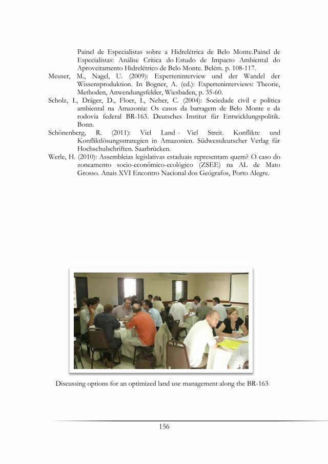
156
Painel de Especialistas sobre a Hidrelétrica de Belo Monte.Painel de Especialistas: Análise Crítica do Estudo de Impacto Ambiental do Aproveitamento Hidrelétrico de Belo Monte. Belém. p. 108-117.
Meuser, M., Nagel, U. (2009): Experteninterview und der Wandel der Wissensproduktion. In Bogner, A. (ed.): Experteninterviews: Theorie, Methoden, Anwendungsfelder, Wiesbaden, p. 35-60.
Scholz, I., Dräger, D., Floer, I., Neher, C. (2004): Sociedade civil e polìtica ambiental na Amazonia: Os casos da barragem de Belo Monte e da rodovia federal BR-163. Deutsches Institut für Entwicklungspolitik. Bonn.
Schönenberg, R. (2011): Viel Land - Viel Streit. Konflikte und Konfliktlösungsstrategien in Amazonien. Südwestdeutscher Verlag für Hochschulschriften. Saarbrücken.
Werle, H. (2010): Assembleias legislativas estaduais representam quem? O caso do zoneamento socio-econômico-ecológico (ZSEE) na AL de Mato Grosso. Anais XVI Encontro Nacional dos Geógrafos, Porto Alegre.
Discussing options for an optimized land use management along the BR-163

157
Land Use Regulations in the State of Pará: An Introductory Approach of its Guidelines
José H. Benatti1 & Luly R. da Cunha Fischer2 1University of Pará, NAEA Institute, Belém 2University of Amazonia Law School, Belém
Summary This essay presents the guidelines of ITERPA’s land tenure regularization program in Pará as well as the Federal Government’s land tenure regularization program. It also indicates the existing major problems related to ownership rights and occupation of public lands in Brazilian Amazonia. It presents which legal and administrative changes took place in order to implement these programs.
Key words: Land Tenure, Regularization, Amazonia
1. Introduction The state of Pará is the second largest state in extension of Brazil and presents very complex features in comparison to the other states in the Brazilian Amazonia. For this reason it may be also considered as a living laboratory to think land tenure regularization and territorial planning policies once we can find all types of land use occupation in urban and rural areas, whether in federal, state and private lands.
It is estimated that only in the State of Pará there are 28 million hectares of rural public federal and state lands that have been occupied by different social segments who need State’s recognition of their inhabitance and development of economic activities (Benatti et al. 2006). This situation does not enable them to invest in long term sustainable economic activities once are daily threatened to be removed from where they live and work. The uncertainty related to land ownership also affects municipalities that are not legally authorized to build essential infrastructures (schools, hospitals, roads, etc.) or obtain public funding because they have no ownership rights over the urban areas they have to manage and control. To address this

158
major land problem Pará has created a comprehensive land tenure regularization policy, embodying urban and rural areas over a territory larger than the country of Angola. Considering its positive initial results this program inspired a major federal land tenure program in Brazilian Amazonia called Terra Legal (Lawful Land). These joint efforts represent the biggest existing land tenure regularization program in the world. Their scope is to assure ownership rights, promoting as well economic and social development.
This essay has presents the state’s land tenure regularization program, which will be presented in six parts. First, we will present the available legal possibilities to regularize land tenure in the Brazilian Legal System. After, we will present the legal criteria to grant ownership rights in public lands. The third section will discuss briefly the Federal and State legislative changes related to land tenure and recognition of ownership rights in Pará and Brazilian Amazonia. In sequence, we will describe the employed methodology to regularize rural land holdings. In the fifth part we will discuss the importance of urban land tenure regularization in this program and its expected long-term effects in the population’s wellbeing. And in the last part, we will briefly present what ITERPA and the Federal Government have done to improve its activities in order to accomplish their institutional missions.
2. Land Tenure Regularization of Rural Properties And Ownership Rights The first step in a land tenure regularization program is to grant access to land and natural resources appropriation to different social segments. However, the focus of the land tenure program is the small property because this type of land holder has the most difficulty to access land tenure programs in the northern region.
A Land Tenure Regularization Policy concerns not only the identification of public lands for regularization, but also how individual or collective properties will be constituted; that is, what legal strategies will be used to avoid land speculation and land concentration (Benatti 2011).
Since ITERPA’s land tenure program targets different social segments, it proposes different rules and restrictions when granting ownership rights. Thus, depending on type of regularization ITERPA issues titles (definitive property titles) or concessions (concession of right in rem of use).
The first type corresponds to the document issued in the regularization of municipalities, and individual properties, whether small,
159
medium or large areas. A collective property title may also be issued to quilombolas communities, but in this case this title cannot be sold or have its area divided. Concessions, the second instrument, are only granted for the beneficiaries of rural settlements or urban land tenure regularization programs for low income communities. In both cases, depending on the type of land occupation these concessions can be individually or collectively granted (Treccani 2005).
A concession in Brazilian law assures almost the same rights to beneficiaries who receive properties titles. The difference consists in restrictions to the concession’s beneficiary to acquire other areas, enlarging the area already occupied and to sell it without in the State’s previous approval. The concession is also transferable through succession, as long as the new grantee meets the same criteria for the concession and does not make different use from what is established in the contract. Nonetheless, this limitation does not cause an economic unfeasibility of the property because its proprietary continues with all powers of its use and enjoyment.
These restrictions have the goal to avoid land speculation and concentration, allowing low income rural and urban families, who are normally excluded from the legal land market, to have legal protection of their possessions and real estate transactions. 3. Land Tenure Regularization Criteria of Occupied Public Lands In the process of land tenure regularization the occupation of public lands must be respected, as long as it is not violating legal dispositions. Therefore, occupation is a sine qua non condition for land tenure regularization. Nonetheless, there are situations where certain social groups have priority over others in the land tenure regularization process.
Thus, indigenous groups’ lands, even if occupied by third parties cannot be ever regularized. Similarly, quilombolas communities’ occupation, as long as do not conflict with indigenous interest are in second in the legal priority to ownership rights’ recognition.
Besides these two groups, protected areas come in third for destination of public lands. Thus, if there are people occupying areas in these situations, they will only have their areas regularized if their occupation is compatible with protected areas’ creation.
Fourth in the list of priorities are rural settlements and small properties. In the last category, are medium and large occupations. It is important to mention that municipal donations have priority over land tenure regularization for agrarian purposes, as long as municipal requests do not conflict with conservation units, indigenous and quilombola’s territories.
160
Depending on the land’s size to be regularized, different legal requirements apply. Although there is no disposition in the Constitution that establishes a maximum limit for rural properties in Brazil, we find various constitutional commands that prohibit the State to favor the concentration of land. Thus, the larger the land to be regularized, more stringent the requirements are to grant ownership rights.
Both donated and sold public areas will have issued property titles containing clauses to compel beneficiaries to maintain, conserve, and in certain situations, to restore the environment. Besides, all issued titles/concessions and existing environmental limitations must be registered in the property public registry.
4. The Federal Law Nº 11.952/2009 and the Debate About Social Justice and Environmental Protection The Federal Law Nº 11.952/2009 presents the criteria for land tenure regularization in federal lands in Brazilian Amazonia for areas up to 1500 hectares occupied since December, 2004. The innovation of this law has enabled the direct sale of the land to the occupant instead of subjecting him to lose it in case of a third party higher bidding in a public auction, the general rule. However, this measure was severely criticized.
To dispute main critics is important to analyze in which context this law was enacted. Federal Law Nº 11.952/2009 is part of a new political context, where state and federal agrarian and environmental agencies are focused in a joint approach to combat grilagem, environmental violations, and the enforcement of human rights (Treccani 2001). In this scenario, illegal deforestation violates the possibility of land tenure regularization. Its goal is to give rural producers the possibility to legally explore properties, complying with its social function.
Disputing the second most frequent criticism regarding this federal law, it is not the recognition of ownership rights to medium and large land holding that will favor land concentration. This is already a reality, despite all land reform actions implemented in the last couple of decades, mainly because there are no limits to the land market’s transactions. Thus, as long as there is no restriction to buy and sell rural properties, it is more likely that land concentration will increase. It is our understanding that to have a fair land distribution in Brazil it is necessary to limit property rights.
The Pará State Law n. 7289/2009 was deeply influenced by the enactment of the Federal Law, following its principles and guidelines. In conclusion, despite initial critics, it is expected that federal and State land tenure laws will have an overall positive impact.

161
5. Municipal Land Use Scanning: The Methodology to Regularize Rural Land Holdings One conclusion we could withdraw from ITERPA’s previous land tenure programs is that isolated land tenure regularization only contributes to land concentration, not representing overall improvements for the families who are beneficiaries of land donations or its surroundings. In addition, we also learned that when there is a landowner surrounded by public lands, the property title gains a separated economic value from the land and is used to legalize illegal occupation and economic activities (Souza Filho 1999).
In order to avoid negative effects from isolated land tenure programs ITERPA in the year of 2006, obtained funds from the World Bank to develop an innovative land tenure regularization methodology. This new approach, nowadays used as a model in federal and state land tenure regularization programs throughout Brazilian Amazonia, consists in scanning the whole municipal’s territory, identifying the land occupation (individual farmers, quilombola communities, protected areas, indigenous lands, urban areas, etc) regardless the existence of property rights or compliance with environmental regulations using GPS (global positioning system) technology to build a land use scenario and propose a integrated land tenure and environmental regularization program.
This proposed methodology is divided in four phases: (a) predecessor stage (fase precursora), consisting to collect data about the territory and to inform the population regarding the program that will be developed in the location; (b) registry phase (fase de cadastro) when land holdings are inventoried and social and economic data from land holders’ families are collected; (c) georeferencing phase (fase de geo-referenciamento), when all land holdings, in private and public areas, are located using GPS technology; and (d) land tenure regularization phase (fase de regularização), when, based on the information gathered, ITERPA proposes a land tenure regularization program for state areas or a joint program for state and federal areas.
As a result of this scanning the State seeks: (a) to identify the type of predominant land use in the municipality; (b) to establish the exact location of protected areas; (c) to identify all indigenous and quilombolas communities and their territories; (c) to identify and donate consolidated urban occupations do the local authority, as well preferred areas for urban expansion according municipal ordinances; (d) to identify the amount and location of public (state and federal) areas, as well as the exact location of previously issued property titles; (e) to promote a broad land tenure and environmental regularization program for all land holders (small, medium and large farmers), giving priority to rural settlement projects; (f) to obtain

162
updated social and economic data about each of the 144 municipalities in the state; and (g) to improve agrarian and environmental law enforcements programs, and after the program is finalized, to monitor its progress, improving land regularization strategies.
With this policy we aim to implement a process of continuous, transparent and democratic territorial management, legitimated by different actors (federal, state, municipal and civil society). Thus, the intended objectives are to reduce rural violence and violations to human rights, to assure property rights to different segments of society, to reduce deforestation and to guarantee environmental sustainability. 6. Urban Land Tenure Regularization If we want to implement a comprehensive land tenure regularization program in Pará and Brazilian Amazonia, urban areas cannot be left out of it. Most of the population in Pará, and as well as in other States of Brazilian Amazonia, is located in the state’s capital, towns and villages.
However, despite the fact municipalities are considered members of the Brazilian Federation; these legal entities only own lands if they receive donations from the Federal and States’ governments.
The combination of large amounts of the population living in urban areas of municipalities that have no authority over it is very problematic and results in adverse effects in the people’s quality of life. Trying to address these problems Pará and the Federal Government enacted laws where it is foreseen a simplified donation process of consolidated urban areas to municipalities. Federal and State governments can also help municipalities in urbanization process, creating joint urban land tenure regularization programs for low income inhabitants, providing opportunities of household improvements and urban fixation, reducing urban and rural migration rates.
It is also important to mention that urban land tenure regularization programs in Brazilian Amazonia take into consideration the cultural, social and economic diversity of urban occupation in the region. In this sense, local ordinances are essential to understand this phenomenon.
7. Legal Changes and Improvements on State’s Bureaucratic Apparatus to Implement the Land Tenure Regularization Program in Pará In order to implement the land tenure regularization program in Pará ITERPA also had to adopt some changes in the State’s bureaucratic apparatus. Traditionally State land institutes in Brazil were underfunded, with outdated equipment and with untrained personnel. It is also a fact that land public registries were in no better shape. Therefore, before to start a

163
land tenure program it was necessary first to take some administrative and legal measures create minimal conditions to implement it.
In the last few years the real estate national registry system has been modified to restrain grilagem. This process started in 2001, with Federal Law n. 10.267, which dispositions modernized the demarcation specifications for private properties.
To expedite the land tenure regularization process the Federal Government withdrew from INCRA’s authority this activity. This separation has enabled INCRA to focus on agrarian reform and in the creation of rural settlements, as well as in granting ownership rights to quilombolas communities.
At the State Level, ITERPA updated its regulations, trained its personnel, acquired new equipment, such as GPS, computers, cars and is in the final process in acquiring an appropriated location to develop its activities.
Besides the improvements in infrastructure and capacity building, this existing structure is still insufficient to implement in few years the purposed land tenure program in occupied federal and state areas. For this reason the Federal Government contracted private companies to georeference land holdings in Brazilian Amazonia. The State of Pará used the same strategy in its program, mainly using World Bank’s funding.
Other actions have been taken under state authority to improve control over the existing information of land public registries. As a complimentary activity in the land tenure regularization process all Federal and State land titles issued in Pará since colonial times are being scanned and included in ITERPA’s land database, reducing the risks of data loss and issuance of multiple property titles over the same area.
When this process is completed Pará intends to have for the first time an unified georeferenced land tenure database (with federal and state information) with the location all legally issued property titles, as well as the municipal urban limits, recognized indigenous and quilombolas communities, federal and state conservation units, roads and rivers. This complete data will be permanently updated with the land scanning process in Pará’s municipalities, and will be accessible to public registries in Pará, as well as all public and private institutions through the internet. ITERPA and the Federal Government are also financing the digitization process of public registries in Pará, which will be in a near future integrated to the unified public land database there is already under construction. This measure will nearly eliminate real estate transaction risks caused by grilagem in Pará.
164
8. Conclusions Federal and state land tenure regulation programs purpose an integrated territorial management for Brazilian Amazonia, not only for economic reasons, but as a strategy to improve the quality of life of its inhabitants. To abate violence related to land disputes in Amazonia, in direct violation of human rights; to recognize property rights to different social segments, to reduce illegal deforestation are the main purposes of these programs.
However, to structure a land tenure database is a long-term project, which can only be accomplished with careful planning, and the joint efforts of legislative, judiciary and executive branches from all spheres. The civil society also needs to be directly involved if we desire an expedite process.
References Benatti, J. H., Santos, R. A., Gama, A. S. P. (2006): A grilagem de terras públicas na
Amazônia brasileira. Brasília: IPAM/MMA, Série Estudos n. 8. Benatti, J. H. (2011): Regularização fundiária na Amazônia no contexto das
mudanças climáticas. In: A economia do verde no contexto do desenvolvimento sustentável: a governança dos atores públicos e privados /Carina Costa de Oliveira, Rômulo Silveira da Rocha Sampaio (organizadores). FGV, Direito Rio, Rio de Janeiro, p. 119-212.
Souza Filho, C. F. M. (1999): Direito Agrário e Meio Ambiente, In: Laranjeira R. (ed.): Direito Agrário Brasileiro, LTR., São Paulo, p. 506-517.
Treccani, G. D. (2001): Violência e grilagem: instrumentos de aquisição da propriedade da terra no Pará. UFPA-ITERPA, Belém.
Treccani, G. D. (2005): Os diferentes caminhos para o resgate dos territórios quilombolas. In Boletim Informativo do NUER. Territórios quilombolas. Reconhecimento e Titulação de Terras. vol. 2, n° 2. NUER/UFSC. Florianópolis, p. 111-121.

165
Socio-Economic Regional Change and Agro-Economic
Development Along the BR-163
Martin Coy1, Michael Klingler1, Matthias Siebold2 & Thomas Berger2
1University of Innsbruck, Geography 2University of Hohenheim, Land Use Economics in the Tropics and Subtropics Key words: Dynamics, modeling, income, farmers
The catchment area of the federal highway BR-163 Cuiabá-Santarém in the Federal States Mato Grosso and Pará is a region in transition between savanna and rain forest, between world market and subsistence, in which contrasts between modernization and globalization trends (development of an export corridor for world-market oriented soy production), local/regional interests (pioneer front expansion) and state- or civilian-societal regulation efforts culminate like under a burning lens. Given the intensity of economic and environmental change, the BR-163 region has been brought into international scientific and political discussions. It is a hot spot of the Global Change and has emerged as a central point in discussions regarding international climate politics and sustainable regional development. The municipality of Sinop, which constitutes today the most important regional center of Northern Mato Grosso, emerged only in the mid of the 1970ies from a private colonization project (the name means Sociedade Immobiliária do Noroeste do Paraná). Smallholders from Southern Brazil immigrated in the region and developed during the first years subsistence agriculture and tried to establish – as in their regions of origin – coffee plantations as cash crop and later on alcohol distilleries for the production of biofuel. As a result of these two first land use cycles, many colonists resigned and migrated to the growing pioneer town or continued to new pioneer fronts in other parts of Northern Mato Grosso. Beginning in the 1980ies, particularly within the more southern range of the campos cerrados, the mechanized, world market-directed cultivation of soy and timber extraction widely prevailed.
166
Today the pioneer front, meanwhile consolidated, is worldwide one of the most important areas of soy cultivation. It is therefore directly exposed to varied globalization influences and by way of agribusiness tied into the odds and risks of global value creation chains. The high economic vulnerability and the far-reaching ecological consequences hinder increasingly a sustainable development. As a result, land concentration, a shift from peasants to farmers, the introduction of new production systems characterize the rural structures of the region. Besides the soy cultivation, there have recently been trends in the direction of agro-fuels (sugarcane, castor-oil plants, etc.). Many pioneer towns along BR-163 that resulted from the settlement colonization have in the meantime become prospering regional centers.
Within the recent pioneer front discussion in the Amazon biome the municipality of Novo Progresso, located in the state of Pará, is probably one of the most active regions. Since the construction of the BR-163 highway by the Brazilian military governments, South-Brazilian migrants have been strongly enforced to incorporate the periphery into the national (and global) economic space. As a result the specific land use strategies caused over the years enormous deforestation rates and numerous conflicts over land entitlements. Cattle production and land speculation remain the principal driving force behind the deforestation processes. Smallholder farming continues a driver of forest loss, though far reaching structural changes are replacing these traditional production conditions. As a consequence, numerous displacement processes combined with further illegal land tenure emerge largely as a result of differences in interests and power, leading to a superposition of different social spaces. Another driving force is prospecting for gold. Though, in comparison to the 1980ies, the scale of gold mining has been greatly reduced, mining and prospecting continue, particularly along the Transgarimpeira at the northern reaches of the BR-163 region.
Nowadays deforestation no longer seems to be an act of progress and development. The announcement of integrating the BR-163 into a new export corridor of agribusiness and the construction of export harbors, high expansion rates of cattle ranching and missing governance structures within the region brings the “backbone” for the development in Amazonia into an on-going international discussion on loss of biodiversity and impacts on global climate change. Lately, the municipality stands at the center of public policies embracing the concept of sustainability and supporting regional development strategies to clarify the land title problematic and to assert environmental control and monitoring. The breaking point occurred in 2005, when deforestation rates dropped sharply. Several political and policy
167
changes resulted in new monitoring and controls on the region’s deforestation. Yet it was also a time when large scale ranching expanded rapidly in the region. Also, in recent years, the political discourse of regional development changed leading to a transformation towards a regional sustainability. As the discourse shifted, those who were once seen as the region’s greatest economic engines were now relegated to being its biggest bandits.
Policies aimed at intensifying agricultural production have been recently implemented by the Federal Government and reinforce such transition context. The Low-Carbon Agricultural Plan (Plano ABC) is an interesting example, through which farmers adopting at least one of six selected sustainable practices are offered preferential loans. The so-called “integrated systems” are one of these practices; by combining crop, livestock and/or forestry activities in the same area, integrated systems help restoring soil fertility in degraded pastures, allow for higher cattle stocking rates and help prevent further deforestation.
In 2010, a new unit of the Brazilian National Agricultural Research Corporation (Embrapa) exclusively dedicated to integrated systems was established in the municipality of Sinop (already mentioned at the beginning of this chapter). Local researchers are currently conducting on-farm experiments and generating primary reliable data on both technical and socioeconomic aspects of such systems. Some Carbiocial members have been directly cooperating with them to understand the role of cultural and institutional factors in the process of integrated systems adoption by rural producers. Results generated through qualitative and quantitative research methods (including a comprehensive survey with farmers) revealed a generally positive perception of the technology and also shed light on the drivers and constraints determining its yet limited diffusion.
In terms of agricultural development at the farm level, it is important to consider that farmers’ decision making is triggered by multiple factors at several levels. Amongst the most important ones are (i) world prices for products such as soybean, maize, cotton and cattle, (ii) federal and national policies concerning environmental legislation, infrastructure investments and land tenure regulations and (iii) international, national and regional investment activities. By enhancing the infrastructure (improvements of the network in general, and/or paving the BR-163), transportation will be facilitated through reduced freight costs and risk on both sides, for the means of production, as well as the products. The combination of all these factors constitute, beside the bio-physical elements (e.g. climate and soils) and farm specific characteristics (factor endowment, business orientation, social networks, etc.), the individual decision
168
environment for each farmer. These single farm level decisions in turn determine to a large extent the regional land use and cover change. By coupling the bio-physical model MONICA(1), which calculates crop yields for different soil types, management practices and climate scenarios, with the agro-economic model MPMAS(2), which replicates farmer specific production decisions and simulates farm economic results (e.g. gross margins, income, shadow prices, etc.), we created a powerful tool to analyze human-environment interactions at the various levels of aggregation.
Every single farm within the study region is modeled, taking into account its particular environmental and socio-economic situation. Horizontally, the farmers are linked through network models. This simulation set-up allows us to analyze the adoption and diffusion of innovations – including the above mentioned low-carbon practices – across the study area, as well as their implications on land use. Results from simulation demonstrate that, for example, a change in soy prices affects farm production plans for all farm types (small, medium and large), although price risk differs considerably between these farm types. Furthermore, this modeling package enables the simulation and analysis of the impacts of different climate and policy scenarios on regional- and farm-level land use. 1 MOdel of NItrogen and Carbon dynamics in Agro-ecosystems: http://www.zalf.de/en/forschung/institute/lsa/forschung/oekomod/monica 2 Mathematical Programing-based Multi Agent Systems: https://mp-mas.uni-hohenheim.de/

169
Deforestation Along the BR-163:
Socio-Environmental Conflict and Ignored Governmental Policies
Edna Castro
Federal University of Pará (UFPA), NAEA Institute (Núcleo de Altos Estudos Amazônicos), Belém
Key words: Dynamics, modeling, income, farmers
Governmental policies directed to the region along Highway BR-163 (Cuiabá-Santarém), like the colonization, the economic-ecological zonation, the titling of indigenous lands, and, more recently, the statute articles of forest concessions and other management plans have not fulfilled the desired effects to make this region neither free of violent processes, of land occupation and of keep the forest standing, nor sustained the effects for sustainable, social and economic uses.
In 2009, the “Instituto do Homem e Meio Ambiente” (IMAZON) published a report where lost forest cover areas have been specified. It declared that just in a few months and in three municipalities of Pará, felled forests of 95.1 km² have been found next to the road. For Imazon, the Amazon forest had lost 150 km² in June 2009, meaning a significant decrease in comparison to values of the years before.
Land use data of the above mentioned highway showed in 2012 that the highest rate of deforestation had occurred precisely within the conservation units, exactly within the area that was strictly protected by law, and where it was expected that the interests of land speculation, and occupancy by other different groups, would have been restrained by the impossibility of defined estates. These are, however, areas intended by the State to have just forest concession. In these areas, deforestation follows the path of the road, entering conservation units located along the BR-163 (Jamanxim National Forest) and also harassing lands of indigenous people. Both cases above are located in the State of Pará and lost 121 km2 of forest

170
cover in 2009, while Mato Grosso had lost 11 km2, and in neighboring states such as Rondônia losses of 11 km2 have been reported.
This article aims to analyze the dynamics of land use conflicts and deforestation in the municipalities of Novo Progresso, Itaituba, and Altamira in Southern Pará. All these municipalities experienced big changes and processes due to government infrastructure projects (power, roads, communication), additionally to incentives for the production of agricultural commodities and minerals, causing an increase in interest by the succession of activities on land and thereby increasing rates and land speculation.
Survey-based data on economic and social agents and relationships with deforestation data were used in the three regions. We sought to understand the differences of the strategies of agents in relation to deforestation and the role of conflicts in this context because they are different from one to another area of study. Work still grant the trajectories of agents and economic, and seeks to show their interactions with the (national, state) government policies and local political action. Finally, the results are relevant to provide subsidies and base the discussion on deforestation and climate change in this area of the BR-163 which contains a significant forest cover in the Amazon.

171
List of Authors
Abbruzzini, Thalita F., Department of Soil Sciences, Luiz de Queiroz Higher
School of Agriculture, University of São Paulo, Piracicaba, Brazil, [email protected]
Almeida, Cláudio A., Dr., National Institute for Space Research, Earth Observation Division, São José dos Campos, São Paulo, Brazil, [email protected]
Amorim, Ricardo S. S., Prof. Dr., Faculty of Agronomy, Veterinary Medicine, and Zootechnology (FAMEVZ), Federal University of Mato Grosso, Cuiabá, Brazil, [email protected]
Benatti, José H., Prof. Dr., NAEA Institute, University of Pará, Belém, Brazil, [email protected]
Berger, Thomas, Prof. Dr., Land Use Economics in the Tropics and Subtropics, University of Hohenheim, Stuttgart, Germany, [email protected]
Bertão, Norma, Faculty of Agronomy, Veterinary Medicine, and Zootechnology (FAMEVZ), Federal University of Mato Grosso, Cuiabá, Brazil, [email protected]
Böhner, Jürgen, Prof. Dr., Institute of Geography, University of Hamburg, Germany, [email protected]
Boy, Jens, Dr., Institute of Soil Science, Leibniz University of Hanover, Germany, [email protected]
Brandani, Carolina B., Department of Soil Sciences, Luiz de Queiroz Higher School of Agriculture, University of São Paulo, Piracicaba, Brazil, [email protected]
Castro, Edna, Prof. Dr., NAEA Institute, University of Pará, Belém, Brazil, [email protected]
Cerri , Carlos E. P., Prof. Dr., Department of Soil Sciences, Luiz de Queiroz Higher School of Agriculture, University of São Paulo, Piracicaba, Brazil, [email protected]
Couto, Eduardo G., Prof. Dr., Faculty of Agronomy, Veterinary Medicine, and Zootechnology (FAMEVZ), Federal University of Mato Grosso, Cuiabá, Brazil, [email protected]
Coy, Martin, Prof. Dr., Institute of Geography, University of Innsbruck, Austria, [email protected]
Cunha, Paulo R., Human Geography, University of São Paulo, Procam, São Paulo, Brazil, [email protected]
Dietrich, Helge, Institute of Geography, University of Hamburg, Germany, [email protected]
Diniz, César G., National Institute for Space Research, Amazon Regional Center, Belém-Pará, Brazil, [email protected]

172
Durigan, Mariana R., Department of Soil Sciences, Luiz de Queiroz Higher School of Agriculture, University of São Paulo, Piracicaba, Brazil, [email protected]
Fearnside, Philip M., Dr., National Institute for Research in Amazonia (INPA), Manaus, Brazil, [email protected]
Figueiredo, Adriano M. R., Prof. Dr., Federal University of Mato Grosso do Sul, Campo Grande, Brazil, [email protected]
Fischer, Luly R. da Cunha, Dr., University of Amazonia Law School, Belém-Pará, Brazil, [email protected]
Fraedrich, Klaus, Dr., Meteorological Institute, University of Hamburg, Hamburg, Germany, [email protected]
Gerold, Gerhard, Prof. Dr., Department of Landscape Ecology, Institute of Geography, Georg-August University Göttingen, Göttingen, Germany, [email protected]
Gollnow, Florian, Department of Geography, Humboldt University of Berlin, Berlin, Germany, [email protected]
Gomes, Alessandra R., Dr., National Institute for Space Research, Amazon Regional Center, Belém-Pará, Brazil, [email protected]
Guggenberger, Georg, Prof. Dr., Institute of Soil Science, Leibniz University of Hanover, Germany, [email protected]
Guzha, Alphonce C., Dr., Department of Landscape Ecology, Institute of Geography, Georg-August University Göttingen, Göttingen, Germany, [email protected]
Hartberger, Korbinian, Institute for Latin American Studies, Free University of Berlin, Germany, [email protected]
Hissa, Letícia B. V., Department of Geography, Humboldt University of Berlin, Berlin, Germany, [email protected]
Hohnwald, Stefan, Dr., Department of Landscape Ecology, Institute of Geography, Georg-August University Göttingen, Göttingen, Germany, [email protected]
Hostert, Patrick, Prof. Dr., Department of Geography, Humboldt University of Berlin, Berlin, Germany, [email protected]
Irmler, Ulrich, Prof. Dr., Department of Applied Ecology, Institute for Ecosystem Research, Christian-Albrechts-University, Kiel, Germany, [email protected]
Jungkunst, Hermann F., Prof. Dr., Chair of Geoecology/ Physical Geography, University of Koblenz-Landau, Landau, Germany, [email protected]
Kawohl, Tobias, Institute of Geography, University of Hamburg, Germany, [email protected]
Kilian, Markus, Meteorological Institute, University of Hamburg, Hamburg, Germany, [email protected]
Klingler, Michael, Institute of Geography, University of Innsbruck, Austria, [email protected]

173
Kovács, Kristóf, Department of Landscape Ecology, Institute of Geography, Georg-August University Göttingen, Göttingen, Germany, [email protected]
Lakes, Tobia, Prof. Dr., Department of Geography, Humboldt University of Berlin, Berlin, Germany, [email protected]
Lamparter, Gabriele, Department of Landscape Ecology, Institute of Geography, Georg-August University Göttingen, Göttingen, Germany, [email protected]
Lucarini, Valerio, Prof. Dr., Meteorological Institute, University of Hamburg, Hamburg, Germany, [email protected]
Lunkeit, Frank, Dr., Institute of Geography, University of Hamburg, Germany, [email protected]
Mello-Théry, Neli A. de, Prof. Dr., Human Geography, University of São Paulo, Procam, São Paulo, Brazil, [email protected]
Müller, Hannes, Department of Geography, Humboldt University of Berlin, Berlin, Germany, [email protected]
Nendel, Claas, Dr., Leibniz-Centre for Agricultural Landscape Research (ZALF), Institute of Landscape Systems Analysis, Müncheberg, Germany, [email protected]
Nóbrega, Rodolfo, Department of Landscape Ecology, Institute of Geography, Georg-August University Göttingen, Göttingen, Germany, [email protected]
Peña, Karina P., Department of Applied Ecology, Institute for Ecosystem Research, Christian-Albrechts-University, Kiel, Germany, [email protected]
Schindewolf, Marcus, Dr., Soil and Water Conservation, Technical University of Freiberg, Freiberg, Germany, [email protected]
Schmidt, Jürgen, Prof. Dr., Soil and Water Conservation, Technical University of Freiberg, Freiberg, Germany, [email protected]
Schönenberg, Regine, Dr., Institute for Latin American Studies, Free University of Berlin, Germany, [email protected]
Schönke, Daniela, Soil and Water Conservation, Technical University of Freiberg, Freiberg, Germany, [email protected]
Schumann, Charlotte, Institute for Latin American Studies, Free University of Berlin, Germany, [email protected]
Siebold, Matthias, Dr., Land Use Economics in the Tropics and Subtropics, University of Hohenheim, Stuttgart, Germany, [email protected]
Signor, Denise, Department of Soil Sciences, Luiz de Queiroz Higher School of Agriculture, University of São Paulo, Piracicaba, Brazil, [email protected]
Strey, Robert, Institute of Soil Science, Leibniz University of Hanover, Germany, [email protected]
Strey, Simone, Institute of Soil Science, Leibniz University of Hanover, Germany, [email protected]
174
Unger, Malte, Dr., Department of Applied Ecology, Institute for Ecosystem Research, Christian-Albrechts-University, Kiel, Germany, [email protected]
Vitel, Claudia S. M. N., National Institute for Research in Amazonia (INPA), Manaus, Brazil, [email protected]
Wantzen, Karl M., Prof. Dr., Interdisciplinary Research Center for Cities, Territories, Environment and Society (CITERES-CNRS UMR 7324), François Rabelais University, Tours, France, [email protected]
Yanai, Aurora M., National Institute for Research in Amazonia (INPA), Manaus, Brazil, [email protected]
ISBN: 978-3-86395-138-2 Universitätsdrucke Göttingen Universitätsdrucke Göttingen
The Carbiocial Project investigates viable carbon-optimized land management strategies for maintai-ning tropical ecosystem services under land use change and changing climate conditions in Southern Amazonia – a hotspot of global change. The project aims at understanding the vital natural processes and socio-economic driving forces in the region and develops strategies to enhance and protect carbon stocks in the recently deforested agroscapes of Central/Northern Mato Grosso and South Pará. That is why Carbiocial analyzes and models soil, water and climate as well as agro-economics, social and poli-tical transformations. Based on detailed storylines, the project aims at identifying possible entry-points for a necessary change in local and regional production patterns, considering local livelihoods as well as the present national and global economic, legal and political situation. This book gives an overview of the fi rst results of the multi-disciplinary Carbiocial Project by publishing the main presentations, held on the Carbiocial Status Conference, on October 7-8, 2013, in Cuiabá. In sixteen chapters the authors elucidate the project‘s current state of knowledge, illustrating adapted methods for regional modeling and promising strategies for the Amazon development.
Gero
ld e
t al.
(Eds
.) In
terd
isci
plin
ary
Anal
ysis
and
Mod
elin
g of
Car
bon-
Opt
imiz
ed
Land
Man
agem
ent S
trat
egie
s fo
r Sou
ther
n Am
azon
ia
Interdisciplinary Analysis and Modeling of Carbon-Optimized Land Management Strategies for Southern AmazoniaG. Gerold, H. F. Jungkunst, K. M. Wantzen, R. Schönenberg, R. S. S. Amorim, E. G. Couto, B. Madari, S. Hohnwald (Eds.)
Carbiocial Status Conference in Cuiabá, October 7-8, 2013