Embed Size (px)
Citation preview
Interactive Learner Guide
Cambridge IGCSE® (9–1)Geography 0976
For examination from 2020
Interactive

Learner Guide
2
In order to help us develop the highest quality resources, we are undertaking a continuous programme of review; not only to measure the success of our resources but also to highlight areas for improvement and to identify new development needs.
We invite you to complete our survey by visiting the website below. Your comments on the quality and relevance of our resources are very important to us.
www.surveymonkey.co.uk/r/GL6ZNJB
Learner Guide
3
ContentsSection 1: About this guide 4
Section 2: Syllabus content – what you need to know about 5
Section 3: How you will be assessed 6
Components at a glance 6
About each paper 7
Section 4: What skills will be assessed 11
Section 5: Command words 12
Section 6: Example candidate response 13
Section 7: Revision 18
General advice 18
Before the examination 18
In the examination 19
Paper 1 advice 19
Paper 2 advice 20
Paper 4 advice 20
Revision checklists 22
Theme 1: Population and settlement 23
Theme 2: The natural environment 26
Theme 3: Economic development 29
Section 8: Useful websites 32

Learner Guide
4
Section 1: About this guideThis guide explains what you need to know about your Cambridge IGCSE® (9–1) Geography course and examinations. It will
help you to:
9 understand what skills you should develop by taking this course
9 understand how you will be assessed
9 understand what we are looking for in the answers you write
9 plan your revision programme
9 revise, by providing revision tips and an interactive revision checklist (Section 7).

Learner Guide
5
Section 2: Syllabus content - what you need to know aboutThis section gives you an outline of the syllabus content for this course. You will have three assessments: two theory papers, i.e. Paper 1 (Geographical Themes) and Paper 2 (Geographical Skills), and one practical assessment, either Component 3 (Coursework) or Paper 4 (Alternative to Coursework).
Your teacher will be able to tell you whether you are doing coursework (Component 3) or taking Paper 4. If you are doing coursework, you will complete one assignment and just take Paper 1 and Paper 2 in the examination. However, if you are not doing coursework, you will take three papers in the examination, i.e. Paper 1, Paper 2 and Paper 4.
Make sure you always check the latest syllabus, which is available at www.cambridgeinternational.org.
Learner Guide
6
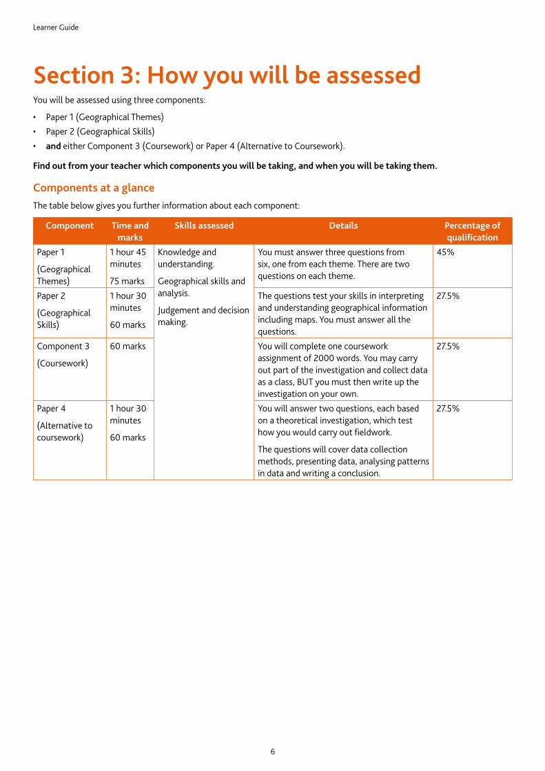
Section 3: How you will be assessedYou will be assessed using three components:
• Paper 1 (Geographical Themes)• Paper 2 (Geographical Skills)• and either Component 3 (Coursework) or Paper 4 (Alternative to Coursework).
Find out from your teacher which components you will be taking, and when you will be taking them.
Components at a glanceThe table below gives you further information about each component:
Component Time and marks
Skills assessed Details Percentage of qualification
Paper 1
(Geographical Themes)
1 hour 45 minutes
75 marks
Knowledge and understanding.
Geographical skills and analysis.
Judgement and decision making.
You must answer three questions from six, one from each theme. There are two questions on each theme.
45%
Paper 2
(Geographical Skills)
1 hour 30 minutes
60 marks
The questions test your skills in interpreting and understanding geographical information including maps. You must answer all the questions.
27.5%
Component 3
(Coursework)
60 marks You will complete one coursework assignment of 2000 words. You may carry out part of the investigation and collect data as a class, BUT you must then write up the investigation on your own.
27.5%
Paper 4
(Alternative to coursework)
1 hour 30 minutes
60 marks
You will answer two questions, each based on a theoretical investigation, which test how you would carry out fieldwork.
The questions will cover data collection methods, presenting data, analysing patterns in data and writing a conclusion.
27.5%
Learner Guide
7
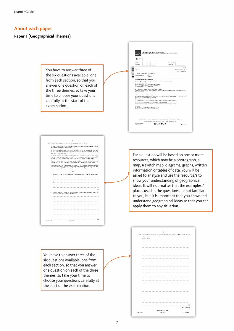
About each paperPaper 1 (Geographical Themes)
You have to answer three of the six questions available, one from each section, so that you answer one question on each of the three themes, so take your time to choose your questions carefully at the start of the examination.
Each question will be based on one or more resources, which may be a photograph, a map, a sketch map, diagrams, graphs, written information or tables of data. You will be asked to analyse and use the resource/s to show your understanding of geographical ideas. It will not matter that the examples / places used in the questions are not familiar to you, but it is important that you know and understand geographical ideas so that you can apply them to any situation.
You have to answer three of the six questions available, one from each section, so that you answer one question on each of the three themes, so take your time to choose your questions carefully at the start of the examination.
Learner Guide
8
Paper 2 (Geographical Skills)
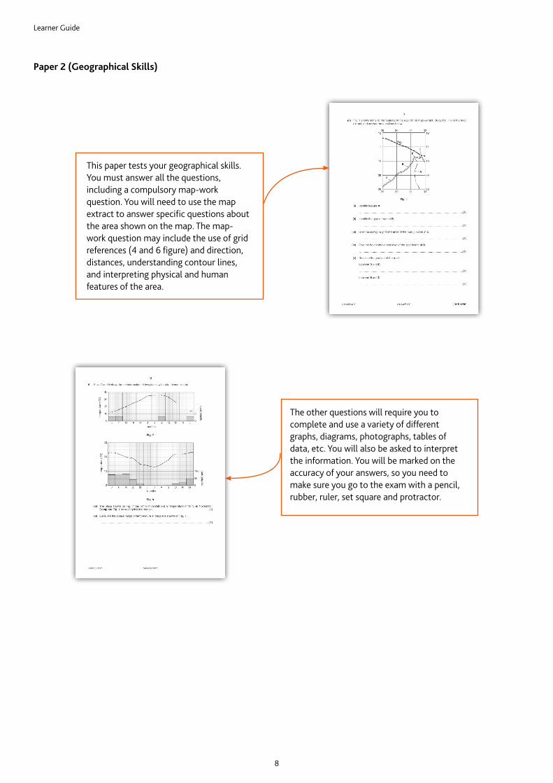
This paper tests your geographical skills. You must answer all the questions, including a compulsory map-work question. You will need to use the map extract to answer specific questions about the area shown on the map. The map-work question may include the use of grid references (4 and 6 figure) and direction, distances, understanding contour lines, and interpreting physical and human features of the area.
The other questions will require you to complete and use a variety of different graphs, diagrams, photographs, tables of data, etc. You will also be asked to interpret the information. You will be marked on the accuracy of your answers, so you need to make sure you go to the exam with a pencil, rubber, ruler, set square and protractor.
Learner Guide
9
About the practical componentsThe remaining components for Cambridge IGCSE Geography test your understanding and skills in a more practical way. They cover your knowledge of all three themes and test the skills you need to investigate geographical ideas. Your teacher will be able to tell you whether you will be entering for coursework, Component 3 (one assignment written in your own time) or the alternative to coursework, Paper 4, which tests the same skills and knowledge as Component 3, but in a timed, written examination.
Component 3 CourseworkYou will carry out one assignment during your geography course, which will be assessed by your teacher. Your teacher will give you marks in five different skill areas. Each skill area is marked out of 12 marks. The teacher will look for certain indicators to assess your work.
Skill 1: Knowledge with understanding
You will be assessed on how well you understand the geographical ideas of the investigation. You need to describe the aims of the investigation and try to explain them using geographical terms. Your teacher may suggest that you devise a hypothesis, which you then try to investigate.
Skill 2: Observation and data collection
You will be marked according to how well you carried out your data collection during the investigation, e.g. whether you followed your teacher’s instructions carefully and with thought. You must also show some ideas of your own about data collection and observation, which go beyond those your teacher told you about.
Skill 3: Organisation and presentation of the results
You will also be marked on how you choose to organise and present your data, e.g. put it into graphs or display it on maps. Better presentations generally use the more varied and complicated presentation techniques. However, you should remember that the methods must be relevant and appropriate, e.g. a bar graph may be a better technique than a line graph to compare the results of traffic surveys carried out at different places.
Skill 4: Analysis and interpretation
You need to write down what your data means. You need to both describe the patterns that you find in the data and explain the reasons for the patterns. For example, you might write, ‘the highest traffic was found at Site X because this was the centre of the town’. If you were then to explain why the centre of the town attracted more traffic, you would be applying your geographical understanding and would be able to access the full range of marks for this skill area.
Skill 5: Conclusions and evaluation
In the final section you will be assessed on how well you are able to conclude the investigation. Did you prove your hypothesis? What data or evidence did you fi nd to support your concluding decisions? You will also be marked on how you criticise and evaluate your data collection methods. You should outline the problems you encountered when collecting the data and suggest better ways of collecting the information for a future investigation.
Learner Guide
10
Paper 4 (Alternative to Coursework)
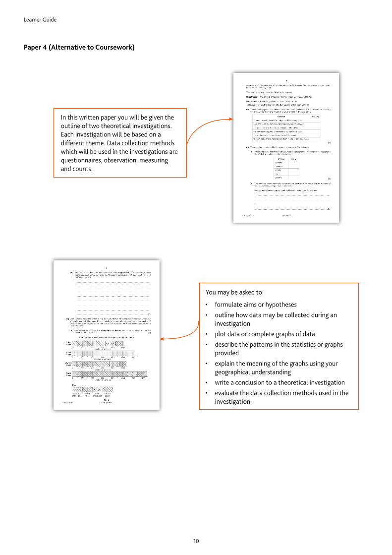
In this written paper you will be given the outline of two theoretical investigations. Each investigation will be based on a different theme. Data collection methods which will be used in the investigations are questionnaires, observation, measuring and counts.
You may be asked to:
• formulate aims or hypotheses• outline how data may be collected during an
investigation• plot data or complete graphs of data• describe the patterns in the statistics or graphs
provided• explain the meaning of the graphs using your
geographical understanding• write a conclusion to a theoretical investigation• evaluate the data collection methods used in the
investigation.
Learner Guide
11
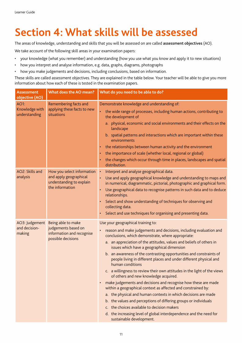
Section 4: What skills will be assessedThe areas of knowledge, understanding and skills that you will be assessed on are called assessment objectives (AO).
We take account of the following skill areas in your examination papers:
• your knowledge (what you remember) and understanding (how you use what you know and apply it to new situations)• how you interpret and analyse information, e.g. data, graphs, diagrams, photographs• how you make judgements and decisions, including conclusions, based on information.These skills are called assessment objectives. They are explained in the table below. Your teacher will be able to give you more information about how each of these is tested in the examination papers.
Assessment objective (AO)
What does the AO mean? What do you need to be able to do?
AO1: Knowledge with understanding
Remembering facts and applying these facts to new situations
Demonstrate knowledge and understanding of:
• the wide range of processes, including human actions, contributing to the development ofa. physical, economic and social environments and their effects on the
landscapeb. spatial patterns and interactions which are important within these
environments• the relationships between human activity and the environment• the importance of scale (whether local, regional or global)• the changes which occur through time in places, landscapes and spatial
distribution.AO2: Skills and analysis
How you select information and apply geographical understanding to explain the information
• Interpret and analyse geographical data.• Use and apply geographical knowledge and understanding to maps and
in numerical, diagrammatic, pictorial, photographic and graphical form.• Use geographical data to recognise patterns in such data and to deduce
relationships.• Select and show understanding of techniques for observing and
collecting data.• Select and use techniques for organising and presenting data.
AO3: Judgement and decision-making
Being able to make judgements based on information and recognise possible decisions
Use your geographical training to:
• reason and make judgements and decisions, including evaluation and conclusions, which demonstrate, where appropriate:a. an appreciation of the attitudes, values and beliefs of others in
issues which have a geographical dimensionb. an awareness of the contrasting opportunities and constraints of
people living in different places and under different physical and human conditions
c. a willingness to review their own attitudes in the light of the views of others and new knowledge acquired.
• make judgements and decisions and recognise how these are made within a geographical context as affected and constrained by:a. the physical and human contexts in which decisions are madeb. the values and perceptions of differing groups or individualsc. the choices available to decision makersd. the increasing level of global interdependence and the need for
sustainable development.
Learner Guide
12
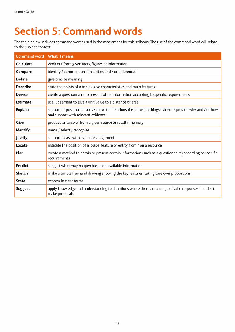
Section 5: Command wordsThe table below includes command words used in the assessment for this syllabus. The use of the command word will relate to the subject context.
Command word What it means
Calculate work out from given facts, figures or information
Compare identify / comment on similarities and / or differences
Define give precise meaning
Describe state the points of a topic / give characteristics and main features
Devise create a questionnaire to present other information according to specific requirements
Estimate use judgement to give a unit value to a distance or area
Explain set out purposes or reasons / make the relationships between things evident / provide why and / or how and support with relevant evidence
Give produce an answer from a given source or recall / memory
Identify name / select / recognise
Justify support a case with evidence / argument
Locate indicate the position of a place, feature or entity from / on a resource
Plan create a method to obtain or present certain information (such as a questionnaire) according to specific requirements
Predict suggest what may happen based on available information
Sketch make a simple freehand drawing showing the key features, taking care over proportions
State express in clear terms
Suggest apply knowledge and understanding to situations where there are a range of valid responses in order to make proposals
Learner Guide
13
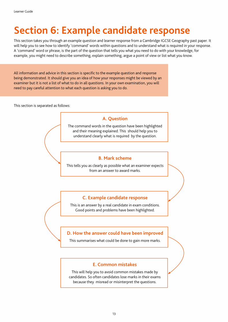
Section 6: Example candidate responseThis section takes you through an example question and learner response from a Cambridge IGCSE Geography past paper. It will help you to see how to identify ‘command’ words within questions and to understand what is required in your response. A ‘command’ word or phrase, is the part of the question that tells you what you need to do with your knowledge, for example, you might need to describe something, explain something, argue a point of view or list what you know.
This section is separated as follows:
All information and advice in this section is specific to the example question and response being demonstrated. It should give you an idea of how your responses might be viewed by an examiner but it is not a list of what to do in all questions. In your own examination, you will need to pay careful attention to what each question is asking you to do.
A. QuestionThe command words in the question have been highlighted
and their meaning explained. This should help you to understand clearly what is required by the question.
B. Mark schemeThis tells you as clearly as possible what an examiner expects
from an answer to award marks.
C. Example candidate responseThis is an answer by a real candidate in exam conditions.
Good points and problems have been highlighted.
D. How the answer could have been improvedThis summarises what could be done to gain more marks.
E. Common mistakesThis will help you to avoid common mistakes made by
candidates. So often candidates lose marks in their exams because they misread or misinterpret the questions.
Learner Guide
14
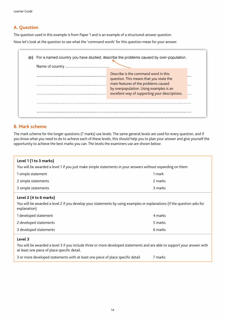
A. QuestionThe question used in this example is from Paper 1 and is an example of a structured-answer question.
Now let’s look at the question to see what the ‘command words’ for this question mean for your answer.
Describe is the command word in this question. This means that you state the main features of the problems caused by overpopulation. Using examples is an excellent way of supporting your descriptions.
B. Mark schemeThe mark scheme for the longer questions (7 marks) use levels. The same general levels are used for every question, and if you know what you need to do to achieve each of these levels, this should help you to plan your answer and give yourself the opportunity to achieve the best marks you can. The levels the examiners use are shown below:
Level 1 (1 to 3 marks)You will be awarded a level 1 if you just make simple statements in your answers without expanding on them
1 simple statement 1 mark
2 simple statements 2 marks
3 simple statements 3 marks
Level 2 (4 to 6 marks)You will be awarded a level 2 if you develop your statements by using examples or explanations (if the question asks for explanation)
1 developed statement 4 marks
2 developed statements 5 marks
3 developed statements 6 marks
Level 3You will be awarded a level 3 if you include three or more developed statements and are able to support your answer with at least one piece of place specific detail.
3 or more developed statements with at least one piece of place specific detail 7 marks
Learner Guide
15
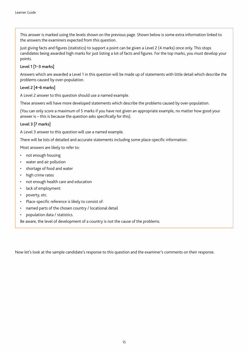
This answer is marked using the levels shown on the previous page. Shown below is some extra information linked to the answers the examiners expected from this question.
Just giving facts and figures (statistics) to support a point can be given a Level 2 (4 marks) once only. This stops candidates being awarded high marks for just listing a lot of facts and figures. For the top marks, you must develop your points.
Level 1 [1–3 marks]
Answers which are awarded a Level 1 in this question will be made up of statements with little detail which describe the problems caused by over-population.
Level 2 [4–6 marks]
A Level 2 answer to this question should use a named example.
These answers will have more developed statements which describe the problems caused by over-population.
(You can only score a maximum of 5 marks if you have not given an appropriate example, no matter how good your answer is – this is because the question asks specifically for this).
Level 3 [7 marks]
A Level 3 answer to this question will use a named example.
There will be lots of detailed and accurate statements including some place-specific information.
Most answers are likely to refer to:
• not enough housing• water and air pollution• shortage of food and water• high crime rates• not enough health care and education• lack of employment• poverty, etc.• Place-specific reference is likely to consist of:• named parts of the chosen country / locational detail• population data / statistics.Be aware, the level of development of a country is not the cause of the problems.
Now let’s look at the sample candidate’s response to this question and the examiner’s comments on their response.
Learner Guide
16
(c) For a named country you have studied, describe the problems caused by over population.
Name of country: Ghana
Ghana is noted to be one of the top countries known to be overly
populated. With this, we see that there is pressure on Ghana’s
resources. The population of Ghana is very high and because of this
water supply would reduce, there would be pressure on the electricity
in Ghana because so many people in the country are using the power.
Ghana’s government revenue would reduce. The government of Ghana
would put in a bit of money to improve medication to new ones,
rebuild hospitals, care homes, provide new and well trained doctors,
re-construct roads bring more water from another place where there
is no supply of water. Ghana has a high rate of crime due to over-
population. When there is a crowded area people who are uneducated
would want to cause a scene and steal and kill people. There is a high
spread of so many diseases in Ghana. Diseases such as cholera due to
the water we drink as a country and also people use dirty hands to
Here the learner has given three well developed statements by linking Ghana’s high population to problems with shortages of water, electricity and limited access to healthcare.
Here the learner tried to make another developed statement by explaining how crime is linked to lack of education. This is not what the question has asked for, so they cannot be awarded any marks for this.
C. Example candidate response and examiner comments
It is good to see the learner planning their response, as it shows they are thinking about how to organise their answer.
• Pressure on Ghana’s resources
• Reduction of government money
• High crime rate• Spread of disease’s• Settlements are
congested (Nima)• Unemployment• Noise
Learner Guide
17
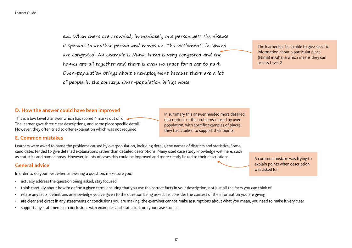
The learner has been able to give specific information about a particular place (Nima) in Ghana which means they can access Level 2.
D. How the answer could have been improvedThis is a low Level 2 answer which has scored 4 marks out of 7. The learner gave three clear descriptions, and some place specific detail. However, they often tried to offer explanation which was not required.
E. Common mistakesLearners were asked to name the problems caused by overpopulation, including details, the names of districts and statistics. Some candidates tended to give detailed explanations rather than detailed descriptions. Many used case study knowledge well here, such as statistics and named areas. However, in lots of cases this could be improved and more clearly linked to their descriptions.
General adviceIn order to do your best when answering a question, make sure you:
• actually address the question being asked; stay focused • think carefully about how to define a given term, ensuring that you use the correct facts in your description, not just all the facts you can think of• relate any facts, definitions or knowledge you’ve given to the question being asked, i.e. consider the context of the information you are giving• are clear and direct in any statements or conclusions you are making; the examiner cannot make assumptions about what you mean, you need to make it very clear• support any statements or conclusions with examples and statistics from your case studies.
In summary this answer needed more detailed descriptions of the problems caused by over-population, with specific examples of places they had studied to support their points.
A common mistake was trying to explain points when description was asked for.
eat. When there are crowded, immediately one person gets the disease
it spreads to another person and moves on. The settlements in Ghana
are congested. An example is Nima. Nima is very congested and the
homes are all together and there is even no space for a car to park.
Over-population brings about unemployment because there are a lot
of people in the country. Over-population brings noise.
Learner Guide
18
Section 7: RevisionThis advice will help you revise and prepare for the examinations. It is divided into general advice for all papers and more specific advice for Paper 1, Paper 2, and Paper 4.
Use the tick boxes to keep a record of what you have done, what you plan to do or what you understand.
For more advice on revision, see the Cambridge Learner Revision Guide on our website.
General adviceBefore the examination
Find out when the examinations are and plan your revision so you have time to revise. Create a revision timetable and divide it into sections to cover each topic.
Find out how long each paper is, how many questions you have to answer, how many marks there are for each question, and work out how long you have for each question.
Find out the choices you have on each paper, make sure you know how many sections there are and which sections you should answer from.
When there is a choice of questions in a section, make sure you revise enough to have a choice.
Know the meaning of the command words used in questions and how to apply them to the information given. Look at past examination papers and highlight the command words and check what they mean.
Make revision notes. Try different styles of notes.
Work for short periods then have a break. Revise small sections of the syllabus at a time.
Test yourself by writing out key points, redrawing diagrams, etc.
Make sure you define geographical terms accurately, e.g. deforestation is not simply ‘cutting down trees’, it is ‘the total deliberate removal or clearance of forest/trees by cutting and/or burning at rates faster than natural regeneration or without replanting’.
Definitions must not reuse the words to be defined. E.g. land pollution means the contamination (pollution) of the earth’s surface (land) by the unplanned or illegal disposal of waste substances.
Make your own dictionary or draw up a glossary of key terms for each section of the syllabus.
Look at maps, diagrams, tables, etc. to find out what they show; e.g., recognising landforms and settlement patterns on maps and photographs.
Practise drawing clear, simple, neat, fully-labelled diagrams and maps.
Learn your case studies thoroughly. What do they show? How you might use them? Where in the world are they? Are they are local, regional, international or global scale? Make a list of case studies for each section of the syllabus. Look at past questions and decide which case study would be best to answer each one. Know your own local case studies, whenever possible.
Learn to spell geographical terms correctly.
Have a look at past questions so that you are clear of what to expect in an examination.
Look at mark schemes to help you to understand how the marks are awarded for each question.
Learner Guide
19
Read the instructions carefully and answer the right number of questions from the right sections.
Do not answer more questions than are needed, as this will not gain you more marks in the examination.
Plan your time according to the marks for each question. For example, a question worth three marks requires less time and a shorter answer than one worth 10 marks. If a question has several parts, then the parts with more marks will need more time and more developed answers.
Do not leave out questions or parts of questions. Remember, no answer means no mark.
Read each question very carefully.• Identify the command words – you could underline or highlight them.• Identify the other key words and perhaps underline them too.• Try to put the question into your own words to understand what it is really asking.Read all parts of a question before starting your answer. Think carefully about what is needed for each part. You will not need to repeat material.
Look very carefully at the resource material you are given.• Read the title, key, axes of graphs, etc. to find out exactly what it is showing you.• Look for dates, scale, and location.• Try using coloured pencils or pens to pick out anything that the question asks you about.Answer the question. This is very important!
Use your knowledge and understanding.
Do not just write all you know, only write what is needed to answer the question.
Plan your answers. Clear, concise, well-ordered, well-argued, well-supported answers get more marks than long, rambling, muddled, repetitive ones. Quality is better than quantity.
Use geographical terms in your answers as much as possible.
Use the resource material given in the question to support your answer.
Annotated maps, diagrams and graphs can help you, and be used to support your answer. Use them whenever possible but do not then repeat the information in words.
Use case study material even when it is not required specifically by the question. Case studies and examples can come from your home area.
Make sure your writing is clear and easy to read. It is no good writing a brilliant answer if the examiner cannot read it.
In the examination
Learner Guide
20
Look at the instructions on the front of the paper. You have to choose three out of the six questions, one out of two questions in each section so that you answer a question on each of the three themes.
Do not try to answer all the questions, you will not have time to answer them properly.
Write the answers to the questions in the spaces in the question and answer booklet provided, using this as a rough guide to the amount of detail and length of answer that is needed. If you run out of space continue the answer on the spare lined sheet at the back of the booklet. Make sure you number any continuation answers carefully and also indicate that your answer is continued on the extra page at the end of your partly-written answer.
Look at the number of marks available for each part of a question. Do not spend too much time on one part if it is only worth one or two marks, or alternatively write only a short answer when a question is worth more marks. Timing is important, do not spend too much time on your first chosen question, otherwise you will have to rush the last question. Just in case you run out of time, if there is a question which you are not confident on, answer it last.
Read the information given in the stem of the question carefully as well as the questions themselves.
Wherever possible in your answers try to include relevant examples and case studies. There may be local examples which you could use in your answers.
Where you are asked to complete an answer by labelling or drawing on a resource you must do this rather than writing an answer. If you use any extra sheets make sure that you put your name on them and attach them to your answer booklet before handing it in.
When you are asked to use a written resource you will not be given marks for copying out sections from it. Look at the question you are being asked and try to show your understanding by answering in your own words.
If you are asked to compare or describe the differences between two things it is no good just writing about one. You could use words like ‘bigger’ or ‘more’ to help you compare or a word like ‘whereas’ in the middle of your sentence, e.g. ‘a constructive wave deposits material on the coast whereas a destructive wave erodes material from it’.
Try to be as precise as possible as vague statements are unlikely to get you many marks. e.g. ‘A Stevenson Screen is used to get accurate readings’ is far too vague. You need to give details explaining why readings are accurate when a Stevenson Screen is used (the louvers allow a free flow of air, the white surface reflects the sun’s rays, it allows you to take temperatures in the shade etc.).
Make sure you know the differences between global environmental problems which you may have studied. Many people mix up global warming, ozone depletion and acid rain. You must also make sure you do not mix up causes and effects /consequences – you may be asked for one or the other so read the question carefully.
Paper 1 advice
Learner Guide
21
Paper 2 adviceThis paper is testing a range of skills. Try to be as accurate as you can with measuring and plotting. Take your time, take care and always use a ruler to complete graphs and measure straight line distances.
Many questions ask you to ‘use the evidence’ in the resources provided such as the maps, photographs and graphs. You must make sure that you do so rather than using your background knowledge, e.g. if you are asked to describe the features of an industry shown in a photograph there is no need to include general information about that industry and its location. If you are asked to describe features of a coastal area shown on a map there will be no credit for explaining how they were formed. If you are asked to use evidence from the map to explain why there are no settlements in some areas there is no point in referring to the climate as the map extract is unlikely to include information about it.
Practise basic map skills, for example six-figure grid references. Candidates sometimes get the third and sixth figures confused. Make sure you give the reference for the position of the symbol rather than the name of the place.
If you are asked to measure a distance it is worth using the linear scale below the map and a straight edged piece of paper. By doing this you will be less likely to make mistakes which are possible when using calculation to convert centimetres to kilometres and metres. Look carefully at what units you need to use, whether you should answer to the nearest kilometre or in metres. Make sure you always give the units in your answer rather than just writing down the number.
You could be asked to give a direction or a compass bearing. Make sure you know the difference and check which of the features you are measuring from and to, by looking carefully at the wording of the question.
If you are asked to draw a graph be as accurate as you can, measuring carefully and using a ruler. Take care to draw the type of graph that the question asks for rather than a different type of graph.
Make sure you know how to draw and read a divided bar graph; it is used in a different way from a normal bar graph.
This paper is an alternative to coursework and to prepare for it you need to be able to answer questions about collecting, presenting and analysing data like you would in a geographical investigation. There is nearly always a question that asks you to write a conclusion and an evaluation. You need to practise these skills.
Many of these questions are based on a hypothesis. Make sure you are familiar with testing hypotheses.
You will be given resources to use in the examination which you have not seen before, perhaps different types of graphs or diagrams. Look at the diagrams carefully and think carefully about what they are showing before you answer the questions. You may be asked to complete a diagram, in which case you need to complete it accurately and carefully.
You will have to answer questions about data which has already been collected as part of an investigation. This could be a set of figures, graphs or maps. One of the things you will be asked to do is to recognise and describe patterns or trends, e.g. the distribution of rainfall over an area as shown on a map or over time as shown on a graph, the amount of erosion alongside a footpath as shown on a diagram. You should practise this skill, using data which you have collected yourself, or data from your teacher.
If you are asked questions about the data in the resources you will be expected to use that data rather than simply listing or repeating the figures, e.g. you may be asked to compare two sets of data about different places, look for a relationship between two or more sets of data or recognise similarities and differences. However it is always useful to support your answer by referring back to the resource and quoting data from it.
Learn about the different types of samples that can be used when collecting data – you may be asked to describe the advantages of using systematic or stratified sampling for example. Many candidates assume that the only sample that can be taken is a random sample.
You may be asked to suggest practical ways in which something could be improved. This could be an actual investigation or something which has been investigated, e.g. the amount and distribution of pollution in a river. You will be expected to be realistic in your suggestions so always think about whether they are practical. For example to suggest that all the residents of a town should be interviewed rather than taking a sample is unrealistic. Similarly, to suggest that all factories alongside the river are shut down is not a suggestion which is practical.
When asked to write a conclusion you need to look at the evidence and then say whether you think the hypothesis is correct or not. In a few cases it may be only partly correct. You must then give evidence to support your conclusion. This evidence must be based on the data provided in the question.
Paper 4 advice
Learner Guide
22
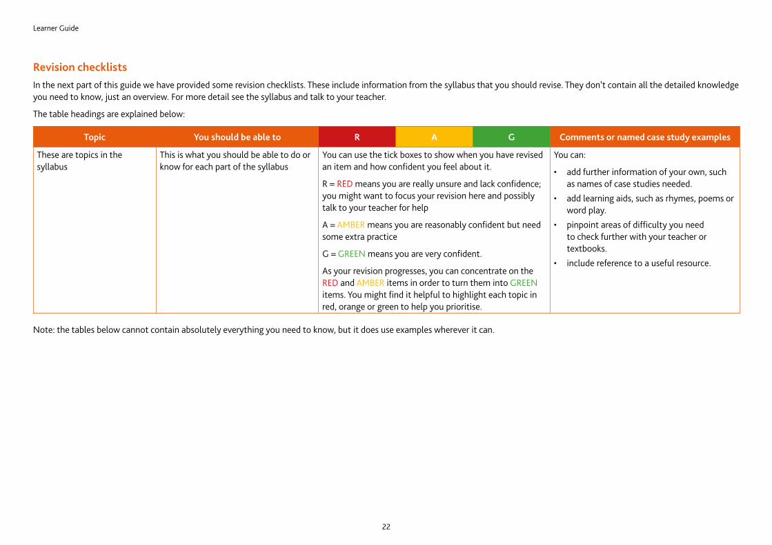
Revision checklistsIn the next part of this guide we have provided some revision checklists. These include information from the syllabus that you should revise. They don’t contain all the detailed knowledge you need to know, just an overview. For more detail see the syllabus and talk to your teacher.
The table headings are explained below:
Topic You should be able to R A G Comments or named case study examples
These are topics in the syllabus
This is what you should be able to do or know for each part of the syllabus
You can use the tick boxes to show when you have revised an item and how confident you feel about it.
R = RED means you are really unsure and lack confidence; you might want to focus your revision here and possibly talk to your teacher for help
A = AMBER means you are reasonably confident but need some extra practice
G = GREEN means you are very confident.
As your revision progresses, you can concentrate on the RED and AMBER items in order to turn them into GREEN items. You might find it helpful to highlight each topic in red, orange or green to help you prioritise.
You can:
• add further information of your own, such as names of case studies needed.
• add learning aids, such as rhymes, poems or word play.
• pinpoint areas of difficulty you need to check further with your teacher or textbooks.
• include reference to a useful resource.
Note: the tables below cannot contain absolutely everything you need to know, but it does use examples wherever it can.
Learner Guide
23
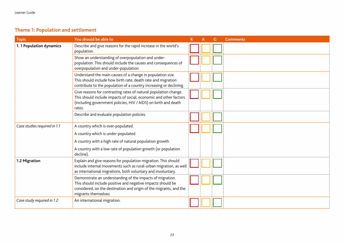
Topic You should be able to R A G Comments1. 1 Population dynamics Describe and give reasons for the rapid increase in the world’s
population.Show an understanding of overpopulation and under-population. This should include the causes and consequences of overpopulation and under-population.Understand the main causes of a change in population size. This should include how birth rate, death rate and migration contribute to the population of a country increasing or declining.Give reasons for contrasting rates of natural population change. This should include impacts of social, economic and other factors (including government policies, HIV / AIDS) on birth and death rates.Describe and evaluate population policies.
Case studies required in 1.1 A country which is over-populated.
A country which is under-populated.
A country with a high rate of natural population growth.
A country with a low rate of population growth (or population decline).
1.2 Migration Explain and give reasons for population migration. This should include internal movements such as rural-urban migration, as well as international migrations, both voluntary and involuntary.Demonstrate an understanding of the impacts of migration. This should include positive and negative impacts should be considered, on the destination and origin of the migrants, and the migrants themselves.
Case study required in 1.2 An international migration.
Theme 1: Population and settlement
Learner Guide
24
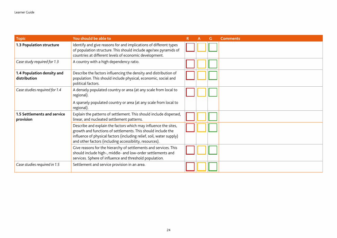
Topic You should be able to R A G Comments1.3 Population structure Identify and give reasons for and implications of different types
of population structure. This should include age/sex pyramids of countries at different levels of economic development.
Case study required for 1.3 A country with a high dependency ratio.
1.4 Population density and distribution
Describe the factors influencing the density and distribution of population. This should include physical, economic, social and political factors.
Case studies required for 1.4 A densely populated country or area (at any scale from local to regional).
A sparsely populated country or area (at any scale from local to regional).
1.5 Settlements and service provision
Explain the patterns of settlement. This should include dispersed, linear, and nucleated settlement patterns.Describe and explain the factors which may influence the sites, growth and functions of settlements. This should include the influence of physical factors (including relief, soil, water supply) and other factors (including accessibility, resources).Give reasons for the hierarchy of settlements and services. This should include high-, middle- and low-order settlements and services. Sphere of influence and threshold population.
Case studies required in 1.5 Settlement and service provision in an area.
Learner Guide
25
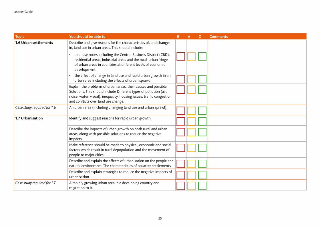
Topic You should be able to R A G Comments1.6 Urban settlements Describe and give reasons for the characteristics of, and changes
in, land use in urban areas. This should include:
• land use zones including the Central Business District (CBD), residential areas, industrial areas and the rural-urban fringe of urban areas in countries at different levels of economic development
• the effect of change in land use and rapid urban growth in an urban area including the effects of urban sprawl.
Explain the problems of urban areas, their causes and possible Solutions. This should include Different types of pollution (air, noise, water, visual), inequality, housing issues, traffic congestion and conflicts over land use change.
Case study required for 1.6 An urban area (including changing land use and urban sprawl).
1.7 Urbanisation Identify and suggest reasons for rapid urban growth.
Describe the impacts of urban growth on both rural and urban areas, along with possible solutions to reduce the negative impacts.Make reference should be made to physical, economic and social factors which result in rural depopulation and the movement of people to major cities.Describe and explain the effects of urbanisation on the people and natural environment. The characteristics of squatter settlements.Describe and explain strategies to reduce the negative impacts of urbanisation.
Case study required for 1.7 A rapidly growing urban area in a developing country and migration to it.
Learner Guide
26
Theme 2: The natural environment
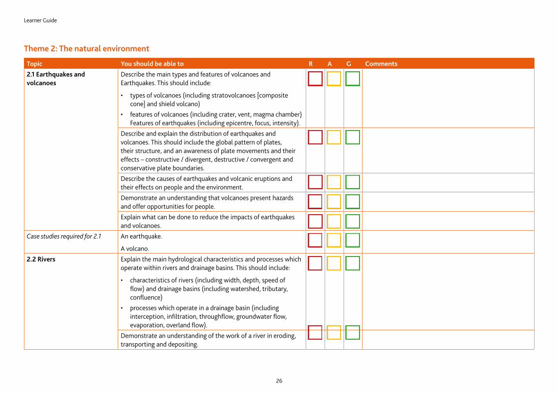
Topic You should be able to R A G Comments2.1 Earthquakes and volcanoes
Describe the main types and features of volcanoes and Earthquakes. This should include:
• types of volcanoes (including stratovolcanoes [composite cone] and shield volcano)
• features of volcanoes (including crater, vent, magma chamber) Features of earthquakes (including epicentre, focus, intensity).
Describe and explain the distribution of earthquakes and volcanoes. This should include the global pattern of plates, their structure, and an awareness of plate movements and their effects – constructive / divergent, destructive / convergent and conservative plate boundaries.Describe the causes of earthquakes and volcanic eruptions and their effects on people and the environment.Demonstrate an understanding that volcanoes present hazards and offer opportunities for people.Explain what can be done to reduce the impacts of earthquakes and volcanoes.
Case studies required for 2.1 An earthquake.
A volcano.2.2 Rivers Explain the main hydrological characteristics and processes which
operate within rivers and drainage basins. This should include:
• characteristics of rivers (including width, depth, speed of flow) and drainage basins (including watershed, tributary, confluence)
• processes which operate in a drainage basin (including interception, infiltration, throughflow, groundwater flow, evaporation, overland flow).
Demonstrate an understanding of the work of a river in eroding, transporting and depositing.
Learner Guide
27
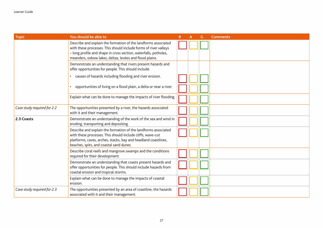
Topic You should be able to R A G CommentsDescribe and explain the formation of the landforms associated with these processes. This should include forms of river valleys – long profile and shape in cross section, waterfalls, potholes, meanders, oxbow lakes, deltas, levées and flood plains.Demonstrate an understanding that rivers present hazards and offer opportunities for people. This should include:
• causes of hazards including flooding and river erosion.
• opportunities of living on a flood plain, a delta or near a river.
Explain what can be done to manage the impacts of river flooding.
Case study required for 2.2 The opportunities presented by a river, the hazards associated with it and their management.
2.3 Coasts Demonstrate an understanding of the work of the sea and wind in eroding, transporting and depositing.Describe and explain the formation of the landforms associated with these processes. This should include cliffs, wave-cut platforms, caves, arches, stacks, bay and headland coastlines, beaches, spits, and coastal sand dunes.Describe coral reefs and mangrove swamps and the conditions required for their development.Demonstrate an understanding that coasts present hazards and offer opportunities for people. This should include hazards from coastal erosion and tropical storms.Explain what can be done to manage the impacts of coastal erosion.
Case study required for 2.3 The opportunities presented by an area of coastline, the hazards associated with it and their management.
Learner Guide
28
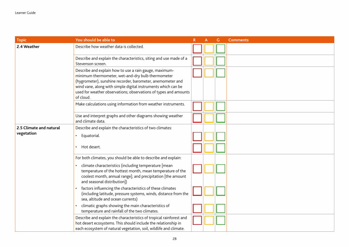
Topic You should be able to R A G Comments2.4 Weather Describe how weather data is collected.
Describe and explain the characteristics, siting and use made of a Stevenson screen.Describe and explain how to use a rain gauge, maximum-minimum thermometer, wet-and-dry bulb thermometer (hygrometer), sunshine recorder, barometer, anemometer and wind vane, along with simple digital instruments which can be used for weather observations; observations of types and amounts of cloud.Make calculations using information from weather instruments.
Use and interpret graphs and other diagrams showing weather and climate data.
2.5 Climate and natural vegetation
Describe and explain the characteristics of two climates:
• Equatorial.
• Hot desert.
For both climates, you should be able to describe and explain:
• climate characteristics (including temperature [mean temperature of the hottest month, mean temperature of the coolest month, annual range]; and precipitation [the amount and seasonal distribution])
• factors influencing the characteristics of these climates (including latitude, pressure systems, winds, distance from the sea, altitude and ocean currents)
• climatic graphs showing the main characteristics of temperature and rainfall of the two climates.
Describe and explain the characteristics of tropical rainforest and hot desert ecosystems. This should include the relationship in each ecosystem of natural vegetation, soil, wildlife and climate.
Learner Guide
29
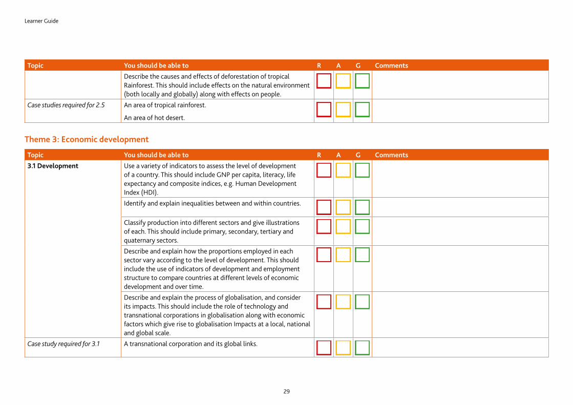
Topic You should be able to R A G CommentsDescribe the causes and effects of deforestation of tropical Rainforest. This should include effects on the natural environment (both locally and globally) along with effects on people.
Case studies required for 2.5 An area of tropical rainforest.
An area of hot desert.
Theme 3: Economic development
Topic You should be able to R A G Comments3.1 Development Use a variety of indicators to assess the level of development
of a country. This should include GNP per capita, literacy, life expectancy and composite indices, e.g. Human Development Index (HDI).Identify and explain inequalities between and within countries.
Classify production into different sectors and give illustrations of each. This should include primary, secondary, tertiary and quaternary sectors.Describe and explain how the proportions employed in each sector vary according to the level of development. This should include the use of indicators of development and employment structure to compare countries at different levels of economic development and over time.Describe and explain the process of globalisation, and consider its impacts. This should include the role of technology and transnational corporations in globalisation along with economic factors which give rise to globalisation Impacts at a local, national and global scale.
Case study required for 3.1 A transnational corporation and its global links.
Learner Guide
30
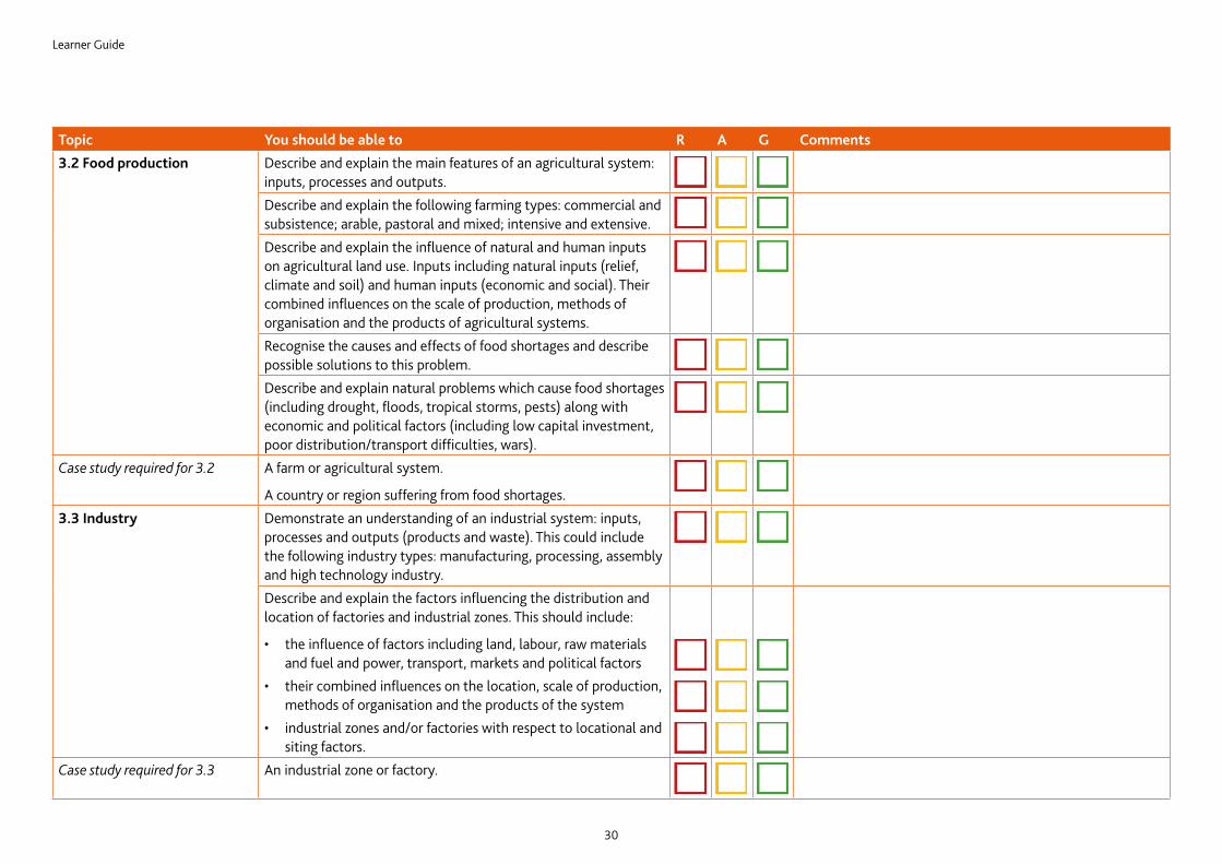
Topic You should be able to R A G Comments3.2 Food production Describe and explain the main features of an agricultural system:
inputs, processes and outputs.Describe and explain the following farming types: commercial and subsistence; arable, pastoral and mixed; intensive and extensive.Describe and explain the influence of natural and human inputs on agricultural land use. Inputs including natural inputs (relief, climate and soil) and human inputs (economic and social). Their combined influences on the scale of production, methods of organisation and the products of agricultural systems.Recognise the causes and effects of food shortages and describe possible solutions to this problem.Describe and explain natural problems which cause food shortages (including drought, floods, tropical storms, pests) along with economic and political factors (including low capital investment, poor distribution/transport difficulties, wars).
Case study required for 3.2 A farm or agricultural system.
A country or region suffering from food shortages.3.3 Industry Demonstrate an understanding of an industrial system: inputs,
processes and outputs (products and waste). This could include the following industry types: manufacturing, processing, assembly and high technology industry.Describe and explain the factors influencing the distribution and location of factories and industrial zones. This should include:
• the influence of factors including land, labour, raw materials and fuel and power, transport, markets and political factors
• their combined influences on the location, scale of production, methods of organisation and the products of the system
• industrial zones and/or factories with respect to locational and siting factors.
Case study required for 3.3 An industrial zone or factory.
Learner Guide
31
Topic You should be able to R A G Comments3.4 Tourism Describe and explain the growth of tourism in relation to the main
attractions of the physical and human landscape.Evaluate the benefits and disadvantages of tourism to receiving areas.Demonstrate an understanding that careful management of tourism is required in order for it to be sustainable.
Case study required for 3.4 An area where tourism is important.
3.5 Energy Describe the importance of non-renewable fossil fuels, renewable energy supplies, nuclear power and fuelwood; globally and in different countries at different levels of development. This should include non-renewable fossil fuels: coal, oil and natural gas. Renewable energy supplies including geothermal, wind, HEP, wave and tidal power, solar power and biofuels.Evaluate the benefits and disadvantages of nuclear power and renewable energy sources.
Case study required for 3.5 Energy supply in a country or area.
3.6 Water Describe methods of water supply and the proportions of water used for agriculture, domestic and industrial purposes in countries at different levels of economic development. This should include methods of water supply (reservoirs / dams, wells and bore holes, desalination).Explain why there are water shortages in some areas and demonstrate that careful management is required to ensure future supplies. This should include the impact of lack of access to clean water on local people and the potential for economic development.
Case study required for 3.6 Water supply in a country or area.
Learner Guide
32
Section 8: Useful websitesThe websites listed below are useful resources to help you study for your Cambridge IGCSE Geography.
www.geographyalltheway.com
This is a wide-ranging site which includes good coverage of the content of the 0976 IGCSE Geography syllabus, which will be useful both to teachers and learners. The approach is lively and there is basic text as well as some good photos, maps, diagrams, links to YouTube and even a few worksheets.
Population dynamics and general informationwww.nationmaster.com
A useful website to compare countries at different levels of development using a wide range of statistics. You can choose which countries or continents to compare and select different statistics including population, economy, agricultural information and environmental pollution data. A bar graph is drawn to show the chosen statistics and the results are mapped. There are further links on your chosen countries giving further information.
Structure and interrelationships of physical and human geographywww.usgs.gov
This is a USA based site and has a lot of good, up-to-date information on the structure of the earth and the hazards of volcanoes and earthquakes. On the home page, go to the alphabetical index and find ‘volcanic activity’ or ‘earthquakes’. The FAQs are good for revision or further explanation. The hazards section provides useful case study information. The most exciting feature of this website is the links for daily monitoring of volcanoes and earthquakes i.e. to see what seismic activity is going on at that precise moment. You can follow the links for a specific US area, e.g. Alaska or select a world map of seismic activity at www.earthquake.usgs.gov/recenteqsww/. By clicking on the map you can obtain further information about the depth and magnitude of the recent earthquake.
www.georesources.co.uk
This is a ‘portal’, i.e. a site which contains useful links to other sites but with a comment on how useful it might be to your studies. It is a very easy site to use. Follow the GCSE link to a list of topics. Select the topic you are studying to find additional information or case study material. The case studies are often from the UK but it does contain many worldwide examples. The ‘Virtual Fieldwork’ section is worth visiting (especially in preparation for Component 3 or Paper 4). This is particularly useful if you have not experienced river studies or are not familiar with coasts or glacial landscapes. The photo gallery is also good. If you need any outline maps of any country then they can be downloaded from here.
www.geography.learnontheinternet.co.uk
This is more like an online geography textbook. Many of the Cambridge IGCSE topics are included under the GCSE Geotopics section. The information is presented in an easy-to-read style with plenty of photographs and diagrams to help you understand. The ‘Activities’ section contains some useful quiz questions in different styles to help you learn the information. There is also a revision section as a summary and a few additional links to other websites.
Population dynamicswww.census.gov
This home page contains the world population clock which constantly updates the number of people in the world. To find and use population pyramids of different countries, follow the link under ‘people’ to ‘international’ and then International Data Base (IDB) and ‘population pyramids’. Select a country, e.g. Namibia and submit the query to show the 2000, 2025 and 2050 expected pyramids. You can also choose a specific date for a pyramid but the most interesting feature is the dynamic pyramid which shows how the population changes over time. Choose countries with different birth and death rates or at different stages of economic development to compare population structures.
Learner Guide
33
Population and settlement and economic development and the use of resourceswww.globaleye.org.uk
This is the website for the magazine ‘Global Eye’ which looks at global development issues. There are three sections for each issue aimed at learners aged 11–15. The first is on a specific country, the second is on a theme and the third is ‘on camera’ which is an interesting set of linked images. The website contains lots of articles which are full of case study material. The ‘Index’ section divides all the articles into themes or countries. Browse through the themes to fi nd case studies on water resources, tourism, urbanisation, migration or flooding for example. The ‘Teachers’ Notes’ give supplementary resources and websites for the latest edition of ‘Global Eye’ and are useful if wanting to investigate the given country or theme in more detail. This website changes often, so it is worth checking regularly.
Economic development and the use of resourceswww.stepin.org
This website is concerned mainly with the use of sustainable technology throughout the world in agriculture, industry and energy resources. It is easy to navigate and provides useful and interesting case studies with photographs. Some of the information is about technical design but a lot of useful case study examples are included which would not be found in textbooks.

Learner Guide
34
Cambridge Assessment International Education1 Hills Road, Cambridge, CB1 2EU, United Kingdomt: +44 1223 553554 f: +44 1223 553558e: [email protected] www.cambridgeinternational.org
Copyright © UCLES December 2017


![[TYPE THE COMPANY NAME]€¦ · Web viewFUN REVISION TEACHER’S RESOURCE DISK: printable PDF activities 2A – 2G, lasting 2 – 15 minutes each INTERACTIVE REVISION 4 interactive](https://img.pdfslide.us/doc/110x75/5fd04f344d87eb032f29b810/type-the-company-name-web-view-fun-revision-teacheras-resource-disk-printable.jpg)
![IGCSE ECONOMICS REVISION CHECKLISTeconomics-igcse.weebly.com/.../igcse_economics_revision_checklist.pdfIGCSE ECONOMICS REVISION CHECKLIST [455] Check for interactive quizzes on IGCSE](https://img.pdfslide.us/doc/110x75/5aeb67627f8b9a585f8d96fa/igcse-economics-revision-checklisteconomics-igcse-economics-revision-checklist.jpg)