Embed Size (px)
Citation preview

Interaction of Bending Angle Assimilation from GNSS
Sensors in the U.S. Navy's Assimilation System
Benjamin Ruston, Steve Swadley, Nancy Baker,
Rolf Langland, and Tim Hogan
Marine Meteorology Division
Naval Research Laboratory
Monterey, CA
2nd International Radio Occulation Working Group - Workshop
Estes Park, CO 28 March – 03 April, 2012

NCODA NRL Coupled Ocean Data Assimilation System
Multivariate Analysis of ocean u,v,T,s,ice,SSH,SWH.
Global, Regional, Local Ocean Data Assimilation.
NAVDAS NRL Atmospheric Variational Data Assimilation System
3D Variational Analysis, Observation Space.
Global, Regional, or Local Application.
NAVDAS-AR NAVDAS Accelerated Representer
4D Variational Analysis, Weak Constraint, Model Space.
Global or Regional Application. High Altitude DA.
ADJOINTS NAVDAS(–AR) Adjoints of 3D & 4D Data Assimilation Systems
NOGAPS TLM; Moist Adjoint
COAMPS®TLM; Moist Adjoint, including explicit moist physics
NAVOBS NAVDAS-Adjoint OBservation Monitoring System (web-based) Real-time monitoring of all data assimilated.
Identification of observation quality problems.
Real-time data selection and data targeting.
EnKF Ensemble Kalman Filter Algorithm
Testing for COAMPS® using real observations.
EnKF/4DVAR Hybrid for the NAVDAS-AR framework.
Navy’s Data Assimilation Tools

NRL/FNMOC Global Analysis System
NRL Scientists developed and transitioned to FNMOC the first operational
global 4D-Var in the United States: 23 September 2009
• Full 4D-Var algorithm solved in observation space using representer approach
• Weak constraint formulation allows inclusion of model error
• T319L42, model top at 0.04 hPa (~70 km)
• More effective use of asynoptic and single-level data
• More computationally efficient than NAVDAS (3D-Var) for large # of obs – NAVDAS assimilated ~500K observations in each cycle
– NAVDAS-AR assimilates 2.0 M observations per cycle
• Adjoint developed for observation impact with real-time web monitoring capability, computed 4x/day
NAVDAS-AR – NRL Atmospheric Variational Data Assimilation System-Accelerated Representer

Brief Timeline of NAVDAS-AR (4D-Var)
NAVDAS-AR (strong constraint, CRTM) Sep2009
New Satellite Data sources added or improved with NAVDAS-AR IASI, AIRS assimilation added, refined and skill improved; NOAA-19 AMSU-A
DMSP F16, F17, F18 UPP operational; Assimilating radiances, surface winds, TPW, ice
ASCAT, WindSAT (winds and TPW)
T319L42 NOGAPS (increased horizontal & vertical resolution) May2010
Subsequent sensors added to NAVDAS-AR GPS RO bending angle Sep2010
COSMIC, GRAS, GRACE-A, Terra SAR-X, SAC-C, C/NOFS
RARS ATOVS retransmission data Sep2010
Combined LEO/GEO atmospheric motion vectors (AMV) Nov2010
Hourly geostationary winds (AMV) from MTSAT, Meteosat and GOES-W Dec2010
MHS and SSMIS 183 GHz channel assimilation Jan2011
Sensors and enhancements to be added to NAVGEM • Variational bias correction
• SBU/V and OMPS ozone
• HIRS and Geostationary Clear-Sky Radiance
• Aerosols, clouds, land surface

Data Assimilation provides initial conditions to the NWP forecast model
H(xf) - nonlinear mapping from state into ob space
HT - linearized operator
xa =Analysis
Error assumptions Pf - model state; R - observation
xf = Model forecast “background”
y = Observations
Innovation
Length of model state vector: 107 – 108 Number of obs: 106
Combine a relatively accurate “first guess” model forecast with a variety of observations, and produce an analysis that observes the mass/wind balances found in nature.

NOGAPS/NAVDAS-AR Operational System Observational Data Types Assimilated
Conventional Data Types • Radiosondes and Pibals • Dropsondes • Driftsonde (Concordiasi) • Land and Ship Surface Obs • Aircraft Obs
• AIREPS • AMDAR • MDCRS
• Synthetic Obs • TC Bogus
Satellite Data Types • Surface Winds
• Scatterometer, ASCAT and ERS-2 • SSMI/SSMIS • WindSat
• Feature Tracked Winds • Geostationary (6 satellites) • Polar Orbiters (AVHRR and MODIS) • Combined polar/geo winds (CIMSS)
• Total Water Vapor • SSMI/SSMIS TVAP • WindSat TVAP
• GPS Bending Angle • IR Sounding Radiances
• IASI and AIRS • MW Sounding Radiances
• 6 AMSU-A (Ch 4-14) • 3 SSMIS (Ch 2-7, 22-24) • 3 SSMIS/3 MHS 183 GHz

• Addition of GPS bending angle assimilation • no bias correction, very low error 8km – 30km • EUMETSAT GRAS-SAF Software Deliverable ROPP* version 4
• *Radio Occultation Processing Package • COSMIC FM1-6; GRAS MetOp-A; GRACE-A; Terra SAR-X, SAC-C, and C/NOFS
CORISS
• Additional IR/MW radiance for stratospheric channels: 4 -- AMSU-A: ch 11-14 3 -- SSMIS: ch 22-24 10 -- IASI: 122, 128, 135, 141, 148, 154, 161, 173, 185, 187
• Assimilate 24 IASI stratospheric channels over land/sea-ice prior use of hyperspectral was over open ocean only
• Perform consistent antenna pattern correction for all AMSU-A AVHRR and ATOVS Preprocessing Package (AAPP)
• Supplement real-time AMSU-A data feed with RARS adds 10-15% more data to real-time OPS run
FNMOC OPS Upgrades Sep 15, 2010

GPS Bending Angle Monitoring
Bending Angle innovation normalized by the background bending angle
Before GPS assimilation After GPS assimilation
global innovation statistics
Mar 16, 2011 Jan 24, 2009

Before GPS assimilation After GPS assimilation
GPS Bending Angle: Raob Impact 30-day global innovation statistics
Aug15-Sep15, 2010 Sep15-Oct15, 2010

GPS Bending Angle Impacts MW sounder radiance
The assimilation of GPS reduced a stratospheric bias which dramatically
improved the raw departures (observed – simulated) shown in blue
Due to the stratospheric improvement these channels were added to the operational assimilation system:
AMSU-A: ch 11-14 (5x: NOAA-15, -16, -18, -19 and MetOp-A) SSMIS: ch 22-24 (3x: DMSP F16, F17 and F18)

GPS Bending Angle Impacts IR sounder radiance
Similarly the improved stratosphere due to GPS impacted the standard deviation (STDV) of the bias corrected departures (observed – simulated) for IASI shown on left As a result additional channels were added for both the IASI and AIRS hyperspectral IR sounders:
10 additional for IASI 31 additional for AIRS
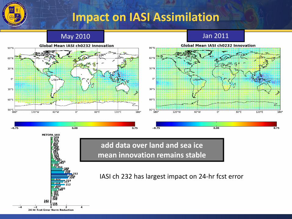
Impact on IASI Assimilation
IASI ch 232 has largest impact on 24-hr fcst error
add data over land and sea ice mean innovation remains stable
Jan 2011 May 2010

Bias Correction Experiment
• Satellite radiances are bias corrected while radiosondes and GPS bending angle are not • Start two experiments: ZZtop & varBC (01Oct – 01Dec, 2011)
• Identical initial conditions • Spin-up (zero bias correction at the beginning )
Variational bias correction typically longer spin-up times
• Both bias correction schemes contain Offset Scan position predictor Two airmass predictors 850-300 hPa, 200-50hPa
ZZtop - Offline Bias Correction: Harris and Kelly (2001) style using statistics from creation of past analysis varBC - Variational Bias Correction: New corrections are part of 4D-Var minimization. This allows for dynamic fitting between all observation types (i.e. raob and GPS can correct radiances directly)

Bias Correction Experiment
varBC ZZtop
Data Stoplight Chart
• Gross check to ensure all data types were used consistently between experiments
• Does not show fine-scale differences in data usage
Oct16-Nov15, 2011

varBC
ZZtop
AMSU-A bias spin up Bias Correction Experiment
• Conventional wisdom always said: Variational bias correction (lower two figures) can take up to a month to converge on a bias correction
Oct01-Oct31, 2011

varBC
ZZtop
AMSU-A bias spin up Bias Correction Experiment
• Looks like both methods are still converging after 45 days!
Oct16-Nov15, 2011

varBC
ZZtop
Raob Temperature Bias Correction Experiment
• Variational bias correction overall better fit, particularly in the stratosphere • ZZtop analysis fit clearly better in mid- to upper-troposhere (weakly influenced by GPS)
Oct16-Nov15, 2011
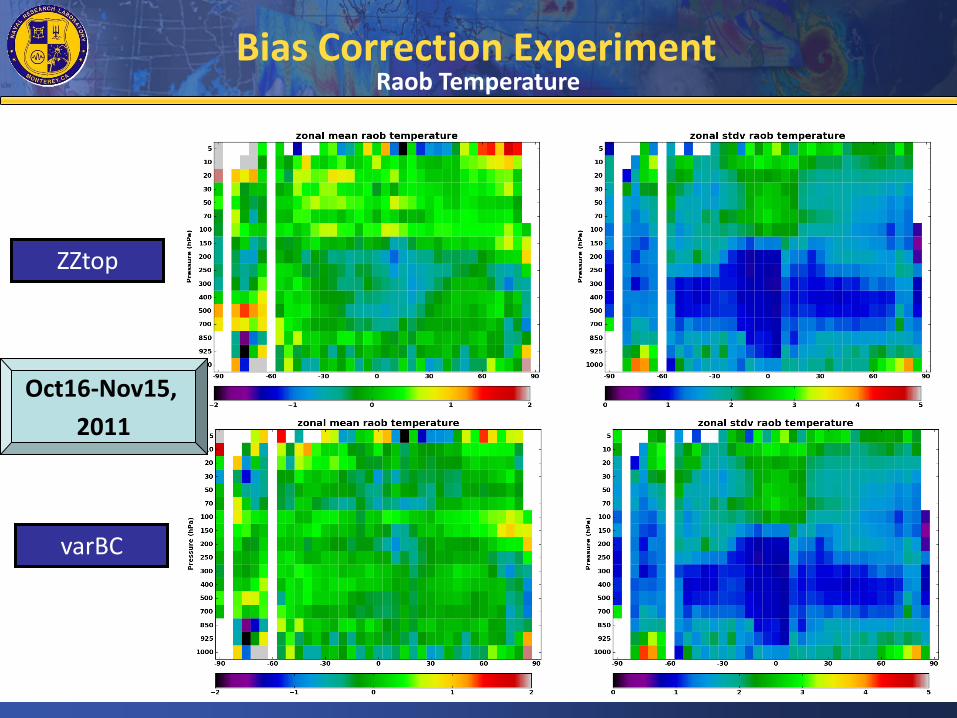
varBC
ZZtop
Raob Temperature Bias Correction Experiment
Oct16-Nov15,
2011

varBC ZZtop
GPS innovation statistics Bias Correction Experiment
• Variational bias correction does fit GPS sensors more closely • Issues with NWP model have been corrected; resulting in a better depiction of the stratosphere in general
Oct16-Nov15, 2011

varBC
ZZtop
GPS innovation statistics Bias Correction Experiment
Oct16-Nov15,
2011

Model impacts: height anomaly correlation Bias Correction Experiment
• If 500hPa anomaly correlations are degraded something is very wrong • A strong impact on 500hPa AC is not expected

Model impacts: height RMS errors Bias Correction Experiment
• 100hPa geopotential heights should be more directly impacted in this experiment • Better fit to GPS and Radiosonde in the stratosphere translates to lower RMS at 100hPa
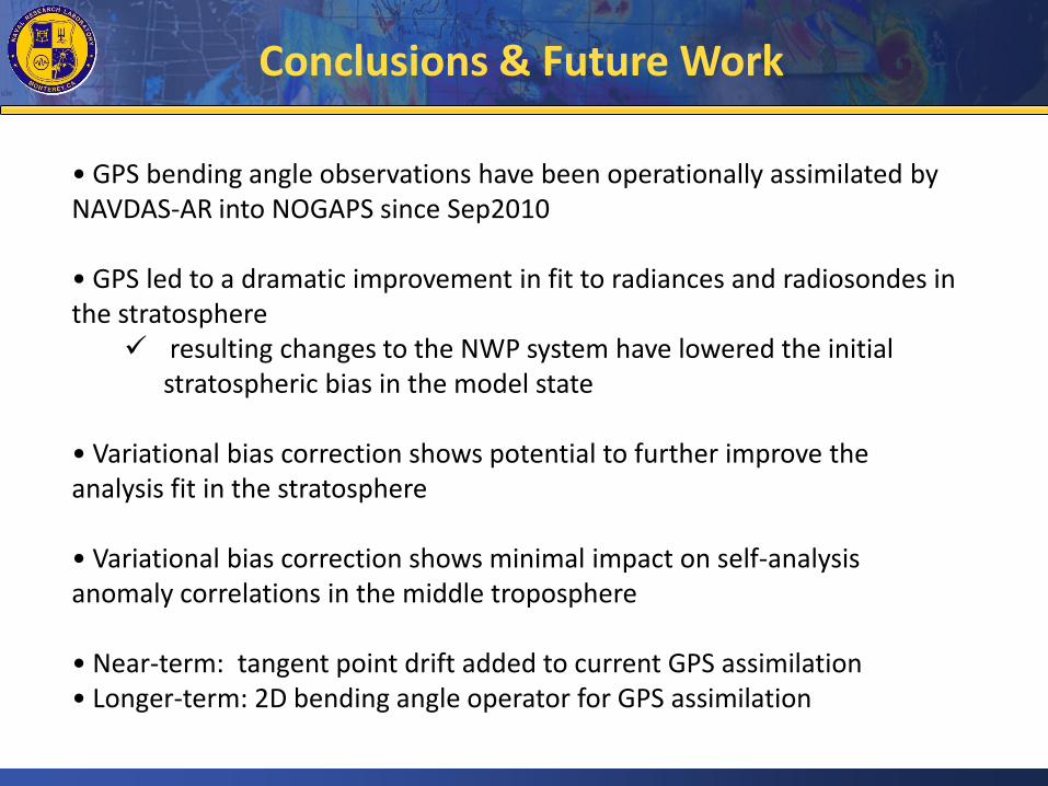
Conclusions & Future Work
• GPS bending angle observations have been operationally assimilated by NAVDAS-AR into NOGAPS since Sep2010
• GPS led to a dramatic improvement in fit to radiances and radiosondes in the stratosphere
resulting changes to the NWP system have lowered the initial stratospheric bias in the model state
• Variational bias correction shows potential to further improve the analysis fit in the stratosphere
• Variational bias correction shows minimal impact on self-analysis anomaly correlations in the middle troposphere
• Near-term: tangent point drift added to current GPS assimilation • Longer-term: 2D bending angle operator for GPS assimilation