Embed Size (px)
Citation preview
Intensifying Agricultural Water Management in the Tropics
A cause of water shortage or a source of resilience?
Yihun Dile
Doctoral thesis in Natural Resources Management
Stockholm Resilience Centre
Stockholm, 2014

Doctoral dissertation 2014
Stockholm Resilience Centre
Stockholm University
SE-106 91 Stockholm, Sweden
©Yihun Dile
ISBN 978-91-7447-914-0, pages 1–67
Cover illustration: Photo taken by the author at the field research area, July 2012
Printed by Universitetsservice US-AB in Stockholm, 2014
ABSTRACT
Frequent climatic shocks have presented challenges for rainfed agriculture in sub-Saharan
Africa. These, compounded with low nutrient input and land degradation, make rainfed
agriculture in the region inefficient and unsustainable. It has been suggested that
appropriate water management practices are among the solutions to these challenges. The
role of water harvesting in achieving sustainable agricultural intensification and specified
resilience against climatic shocks was explored conceptually. Suitable areas for water
harvesting in the Upper Blue Nile basin, Ethiopia, were identified using multi-criteria
evaluation techniques in GIS. The usefulness of the Curve Number method for surface
runoff estimation was evaluated using field data collected from three micro-watersheds in
the Lake Tana sub-basin, and was found to perform satisfactorily under most conditions. A
decision support system (DSS) was developed for locating and sizing of water harvesting
ponds in the Soil and Water Assessment Tool (SWAT) for a double cropping system.
Irrigation from water harvesting ponds was applied to bridge intra-seasonal dry spells
during the rainy season and to cultivate cash crops during the dry season. The DSS
determines the crop water requirement and available flow into the water harvesting ponds.
The impact of climate change on the biophysical systems in the Lake Tana sub-basin was
also studied. Methodological developments enabled analysis of the implications of
intensification of water harvesting in a meso-scale watershed in the Lake Tana sub-basin, in
terms of changes in crop production, environmental flow requirements and sediment loss in
the light of global environmental change.
Results suggest that water harvesting can increase agricultural productivity, sustain
ecosystems and build specified resilience, and thereby contribute to sustainable agricultural
intensification. There is considerable potential to tap the benefits of water harvesting in the
Upper Blue Nile Basin. Rainfall may increase in the Lake Tana sub-basin in the coming
century due to climate change. Supplementary irrigation from water harvesting ponds
combined with better nutrient application increased staple crop (teff) production by up to
three-fold. Moreover, a substantial amount of cash crop was produced using dry seasonal
irrigation. Water harvesting altered the streamflow regime – a decrease in annual
streamflow volume of ~14%–33%, and an increase in annual streamflow volume of up to
25% was observed within a few years. Moreover, its implementation reduced sediment loss
from the watershed.

Water harvesting can play an important role in local to regional scale food security by
increasing staple food production and the generation of extra income from the sale of cash
crops. Water harvesting has a demonstrated potential to buffer climatic variability. In the
watershed studied, water harvesting will not compromise water requirements for the
environment. Instead, increased low flows, and reduced flooding and sediment loss may
benefit the social-ecological systems. The adverse effects of disturbance of the natural flow
variability and sediment influx to certain riverine ecosystems warrant detailed investigation.
A framework for implementing a successful water harvesting scheme is provided in the
thesis.
SAMMANFATTNING PÅ SVENSKA
Extrema väderhändelser är en utmaning för regnbevattnade jordbrukssystem i Afrika söder
om Sahara. I kombination med markförstöring och låg tillförsel av näringsämnen, resulterar
dessa händelser att jordbrukssystemen i stora delar av regionen är både ineffektiva och
ohållbara. Förbättrad vattenförvaltning kan vara en av lösningarna för att hantera dessa
utmaningar. I denna doktorsavhandling undersöktes vilken roll lokal uppsamling av
avrinning spelar för att uppnå ett hållbart intensifierat jordbruk som också är resilient mot
extrema klimatföreteelser.
Initialt kartlades lämpliga områden för uppsamling av avrinning i den övre delen av Blå
Nilens avrinningsområde i Etiopien med hjälp av multivariat analys i GIS (geografiska
informationssystem). För att uppskatta avrinningen prövades en en väletablerad metod i
vilken förhållandet mellan nederbörd och avrinning beskrivs av jordartsspecifika
kurvdiagram. Beräknad avrinning jämfördes med insamlad data från tre mindre
avrinningsområden och visade tillfredsställande resultat under de flesta förhållanden. För
att kunna lokalisera och dimensionera dammar för uppsamling av avrinning, utvecklades ett
beslutsstödsystem i ett hydrologiska analysverktyg, SWAT (Soil and Water Assessment
Tool). Beslutsstödsystemet baseras på grödans vattenbehov och samt tillgången på
ytavrinning. Den uppsamlade nederbörden användes sedan till bevattning för att överbrygga
temporär torka under regnperioden, samt för att kunna odla avsalugrödor under den
efterföljande torrperioden. Därtill utverderades även effekterna av klimatförändringarna på
de biofysiska systemen i Lake Tanas avrinningsområde. Denna metodutveckling möjliggör
en analys av konsekvenser av en intensifierad uppsamling av avrinning för
bevattningsändamål i Lake Tanas avrinningsområde, framför allt med avseende på
jordbrukssystemets avkastning, nedströms liggande ekosystems förmåga att möta sina
flödesbehov, samt sedimentations-förluster uppströms, inom ramen för globala
miljöförändringar.
Resultaten ger vid handen att lokal uppsamling av avrinning kan öka produktiviteten inom
jordbruket, upprätthålla ekosystemfunktioner och skapa social och ekologisk resiliens, och
därmed bidra till en hållbar intensifiering av jordbruket. Det finns en stor potential i den
övre delen av Blå Nilens avrinningsområde för att på ett förtjänstfullt sätt tillämpa lokal
uppsamling av dagvatten. Mycket pekar på att nederbörden kan komma att öka i Lake
Tanas avrinningsområde på grund av klimatförändringarna. Resultaten visar att
stödbevattning från småskaliga dammar i kombination med bättre näringstillförsel
potentiellet kan tredubbla produktionen av huvudgrödan (teff). Dessutom, med hjälp av den
insamlade avrinningen kan en andra gröda, i detta fallet lök, odlas under torrsäsongen med
en hypotetisk avkastning på ca 8 ton/ha. Lokal uppsamling av avrinning påverkade även
vattenföringen i floden nedströms: under vissa år minskade flödet med ~ 14 % -33 %,
medan under andra år ökade vattenföringen med upp till 25 %. Även en minskning av
sedimentförlusterna från jordbruksmarken minskade när lokal uppsamling av avrinning
tillämpades.
Lokal uppsamling av avrinning kan spela en viktig roll för att säkra mattillgången på lokal
och regional nivå genom att livsmedelsproduktionen stabiliseras och även indirekt via extra
inkomster från nya grödor odlade under torrperioden. Vidare har lokal uppsamling av
avrinning visat sig ha potential att buffra klimatvariationer. I det studerade
avrinningsområdet kommer bevattning med lokalt uppsamlad avrinning sannolikt inte att
äventyra de limniska ekosystemens vattenbehov. Snarare visar resultaten från studien på en
ökning av vattenföringen i floderna under torrsäsongen, en minskad risk för
översvämningar, samt mindre sedimentationsförluster, vilket kan ha gynnsamma
samhälleliga samt ekologiska effekter. De negativa effekterna av störningar av naturliga
flödesvariationer, och sedimenttillförsel i limniska ekosystem motiverar en mer ingående
analys. Denna avhandling tillhandhåller dock ett ramverk för hur lokal uppsamling av
avrinning kan implementeras.
Nyckelord: Lokal uppsamling av avrinning, klimatförändringar, klimatvariationer,
multivariat analys, SWAT, Curve Number, Afrika, Etiopien, Blå Nilen, Lake Tana.
PREFACE
This Ph.D. thesis represents five years of scientific work in six papers. The thesis tries to
understand both conceptually and numerically the implications of the intensification of
small-scale agricultural water management interventions for upstream-downstream social-
ecological systems in the context of sub-Saharan Africa. The case studies for the numerical
work are taken from the Lake Tana sub-basin in the Upper Blue Nile basin, Ethiopia.
I started on the journey to this Ph.D. study from a small town called Amanuel. Amanuel
means “God is with us”. It sounds religious – and it is. Every person in the town at the time
I left for college was a Coptic Orthodox Christian. It was a completely homogeneous
society, all speaking the same language, Amharic, and more or less with the same outlook
and basic core principles. I am always amazed when I compare the life in Amanuel with
what I have experienced in the past few years. Time is flying fast; soon it will be 14 years
since I left the town for Arba Minch University. Amanuel is a small town surrounded by an
agrarian society, located in the Upper Blue Nile basin.
To put agriculture in Ethiopia in perspective, it accounts for 47% of GDP, 90% of exports
and 85% of employment. I had two ways of experiencing the life of farmers. My mother
had a small business where she sold her products to farmers. She used to buy foodstuffs and
items for her business from the market on Wednesdays and Saturdays. I helped her both in
the business and to transport the stuff home. In these early roles, the farmers knew me as a
good boy who was helping his parents. The other way I interacted with the farmers was
through our cattle. After school, I kept our cattle in the field – most often close to the
farmers’ crop field. The buffering area between the grazing and the farmers’ crop land often
had good grass that I liked to feed my sheep and cows. The farmers who knew me in this
role considered me a naughty boy. They often thought the ruin of their crops (for whatever
reason) was down to me, because I was often the common denominator in feeding cattle in
the buffer zones. This indicates how deeply I was connected to agriculture, the farmers, the
agrarian economy and ecosystem services in Ethiopia.
The other peculiar thing in Ethiopia is the connection with the Nile River. We call the Nile
Abay (አባይ) in Amharic, which means mighty. Abay is often related to identity and
sovereignty, but people are dissatisfied with the way Abay has been used in the country.
People express these feelings in songs, poems and proverbs. Perhaps the biggest hit song in

Ethiopia is related to Abay. I lived all my life hearing all these melodies and poems – and
for sure this will continue for the rest of my life.
To cut a long story short, it made a lot sense to me to write my Ph.D. on the two core values
that matter most to the Ethiopian community. I hope you enjoy reading it.
ACKNOWLEDGEMENTS
I presume this will be my last chance to write an acknowledgement for a thesis unless I go
for a virtual study, or get a special opportunity as always. Hence, I need to take this
opportunity carefully to express my gratitude for the help and inspiration I have received in
the course of this journey. Many people have played a great role in my life from childhood
to date. I should, however, start with those people who played a direct role in the
achievement of this thesis. Of course, Prof. Johan Rockström and Dr Louise Karlberg are in
the forefront. Thank you Johan and Louise for having the confidence in me and allowing
me to pursue my Ph.D. at the Stockholm Resilience Centre (SRC) at Stockholm University
affiliated with the Stockholm Environment Institute (SEI). I really enjoyed the guidance
and supervision from both of you. You helped me to think independently and also to see the
bigger picture. You provided me with the freedom to experiment in the research, and also
navigate the opportunities all around. I will remember our discussions as challenging,
thought-provoking and productive. I heartily thank you both. The other person who
deserves big thanks is Dr Melesse Temesegne, for his supervision from Addis Ababa
University. Dr Melesse, your insights into the fieldwork were phenomenal. I will never
forget our academic as well as social discussions in Addis coffee shops. I would also like to
thank Dr Getachew Bekele of Addis Ababa University who provided me valuable
feedbacks on how to succeed in my research. Getachew, thanks for your concern and keen
interest in my professional development. Prof. Raghavan Srinivasan is the other person who
has a huge footprint on this research. Prof Srini, you invited me to work with you at the
Spatial Sciences Laboratory at Texas A&M University. I had a very fruitful time with you
and your team at TAMU. I really appreciate your help, and thank you very much for your
continued support. I attended the Young Scientists Summer Programme (YSSP) at the
International Institute for Applied Systems Analysis (IIASA) in Austria in 2013. It was a
very enriching experience both scientifically and socially. I am grateful for the exciting
time I had with all the IIASA staff and the 2013 YSSPers.
I have been overwhelmed every day by the great professionalism, discipline and
productivity of the staff at SEI and SRC. I thank you for your encouragement and
friendship. All the staff certainly followed my development closely and encouraged me all
the way, but there are some people who were closer to my field of research and contributed
more. Dr Mats Lannerstad, thanks for your feedback – which was important to help me
continuously improve. Dr Holger Hoff, thank you for giving me constructive feedback on
two of our papers, and trying to engage me in various interesting projects at SEI. Dr Jennie
Barron, thank you for raising some funds for us for fieldwork and also giving us positive
feedback on one of our papers. Dr Line Gordon, thanks for taking your time to evaluate my
thesis and provide me constructive feedbacks. Dr Lisa Deutsch, Dr Elin Enfors, and Dr
Maja Schlüter, thank you for extending your help through Line. Magnus Benzie, Tom Gill,
Caspar Trimmer and Ylva Rylander, thank you for your help in editing and providing
constructive feedback on our papers. Dr Atakilte Beyene, Linus Dagerskog, Dr Javier
Godar and Beom-Sik Yoo, thanks for our valuable discussions. I owe a large debt of thanks
to Teresa Ogenstad and Astrid Auraldsson Sjögreen for getting me connected to Johan
Rockström, and also for their care and support.
I am among the first batch of Ph.D. students at the Stockholm Resilience Centre. We were
about 10 students and we had some very good times, especially at the beginning of our
student life. We had great discussions and seminars about resilience. However, due to the
multidisciplinary nature of the programme, as my research progressed, I focused more on
my discipline and somehow missed those great discussions. Big thanks to all the first batch
at the Resilience Research School, and also to the incoming Ph.D. students.
I am lucky that my Ph.D. study had a fieldwork component. I should admit this was my
first field experience since my internship as a junior engineer at Tekeze hydropower project
in Ethiopia in 2004. You can imagine how challenging this field experience was. However,
the fieldwork was entertaining because of the warm support I got from Ato Amsalu Meri’s
family. Amsalu is a model farmer in the village where I was doing my field research. He is
knowledgeable about agricultural extension services and watershed development. Amsalu
was sometimes better than me at delineating a watershed. I installed my meteorological
station on his land, and he monitored all of my equipment. His face turned brighter or
darker as mine did when the field equipment worked or failed, as such equipment often
does, unfortunately. I thank all of his family for the unwavering love and support they gave
me. I also thank my field assistants Daniel Yohannes (in 2011) and Gebeyehu (in 2012),
who were always with me in the field. Melekamu Mengist, your help in the field is highly
appreciated.
I would not have achieved this level in life unless I had such a fantastic family who
believed in education. My mother used to advise me that it is better be a poor intellectual
than an illiterate rich man. She did not, however, advise me to be both rich and intellectual.

Who knows, even if uneducated herself, her instinct might have told her that both do not go
together. Instead, she chose that which enriches the mind rather than the pocket. Thank you
to all my family members for infiltrating this mentality to me. You know we are many in
our family, and especially to the fortunate me who happen to have two families, and space
prevents me from mentioning the names of all of you. I really thank you all for the care,
love and encouragement you always give me. However, I have already expressed my
special gratitude to my mother. I thank her again for her tears when we meet and depart,
and sometimes over the phone. Thank you Eme. You were special to me. I would also like
to extend my special thanks to my cousin, Aynalem Getnet, who has represented me in
every matter in Ethiopia. Aynalem, you are a great brother. And Dr Wondimu Bayou,
thank you being a role model in the family.
I have so many dynamic friends in all walks of life distributed all over the world. Friends, I
should have told you that you are always ahead of me in one way or another. It has been a
constant struggle to catch up with you. You are indeed great motivations to start each day.
Thank you for biffing me up and shaping me into what I am today. I am looking forward to
the challenges and inspirations ahead.
This research received funding from the Swedish Research Council for the Environment,
Agricultural Sciences and Spatial Planning (FORMAS). I would like to thank FORMAS for
this extraordinary support.
Finally, I simply say thank you to God, as we say in Amharic – “temesegene” (ተመስገን).
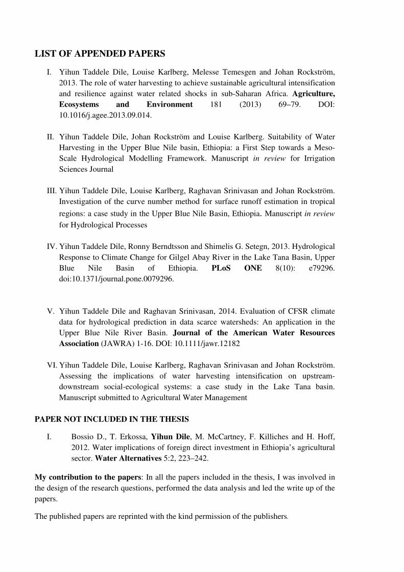
LIST OF APPENDED PAPERS
I. Yihun Taddele Dile, Louise Karlberg, Melesse Temesgen and Johan Rockström,
2013. The role of water harvesting to achieve sustainable agricultural intensification
and resilience against water related shocks in sub-Saharan Africa. Agriculture, Ecosystems and Environment 181 (2013) 69–79. DOI:
10.1016/j.agee.2013.09.014.
II. Yihun Taddele Dile, Johan Rockström and Louise Karlberg. Suitability of Water
Harvesting in the Upper Blue Nile basin, Ethiopia: a First Step towards a Meso-
Scale Hydrological Modelling Framework. Manuscript in review for Irrigation
Sciences Journal
III. Yihun Taddele Dile, Louise Karlberg, Raghavan Srinivasan and Johan Rockström.
Investigation of the curve number method for surface runoff estimation in tropical
regions: a case study in the Upper Blue Nile Basin, Ethiopia. Manuscript in review
for Hydrological Processes
IV. Yihun Taddele Dile, Ronny Berndtsson and Shimelis G. Setegn, 2013. Hydrological
Response to Climate Change for Gilgel Abay River in the Lake Tana Basin, Upper
Blue Nile Basin of Ethiopia. PLoS ONE 8(10): e79296.
doi:10.1371/journal.pone.0079296.
V. Yihun Taddele Dile and Raghavan Srinivasan, 2014. Evaluation of CFSR climate
data for hydrological prediction in data scarce watersheds: An application in the
Upper Blue Nile River Basin. Journal of the American Water Resources Association (JAWRA) 1-16. DOI: 10.1111/jawr.12182
VI. Yihun Taddele Dile, Louise Karlberg, Raghavan Srinivasan and Johan Rockström.
Assessing the implications of water harvesting intensification on upstream-
downstream social-ecological systems: a case study in the Lake Tana basin.
Manuscript submitted to Agricultural Water Management
PAPER NOT INCLUDED IN THE THESIS
I. Bossio D., T. Erkossa, Yihun Dile, M. McCartney, F. Killiches and H. Hoff,
2012. Water implications of foreign direct investment in Ethiopia’s agricultural
sector. Water Alternatives 5:2, 223–242.
My contribution to the papers: In all the papers included in the thesis, I was involved in
the design of the research questions, performed the data analysis and led the write up of the
papers.
The published papers are reprinted with the kind permission of the publishers.
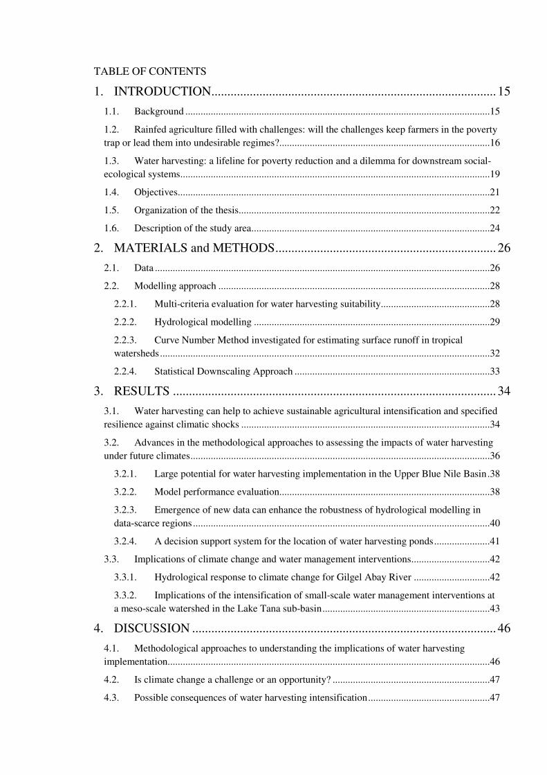
TABLE OF CONTENTS
1. INTRODUCTION......................................................................................... 15
1.1. Background ........................................................................................................................15
1.2. Rainfed agriculture filled with challenges: will the challenges keep farmers in the poverty trap or lead them into undesirable regimes?...................................................................................16
1.3. Water harvesting: a lifeline for poverty reduction and a dilemma for downstream social-ecological systems ..........................................................................................................................19
1.4. Objectives ...........................................................................................................................21
1.5. Organization of the thesis ...................................................................................................22
1.6. Description of the study area ..............................................................................................24
2. MATERIALS and METHODS ..................................................................... 26
2.1. Data ....................................................................................................................................26
2.2. Modelling approach ...........................................................................................................28
2.2.1. Multi-criteria evaluation for water harvesting suitability...........................................28
2.2.2. Hydrological modelling .............................................................................................29
2.2.3. Curve Number Method investigated for estimating surface runoff in tropical watersheds ..................................................................................................................................32
2.2.4. Statistical Downscaling Approach .............................................................................33
3. RESULTS ..................................................................................................... 34
3.1. Water harvesting can help to achieve sustainable agricultural intensification and specified
resilience against climatic shocks ..................................................................................................34
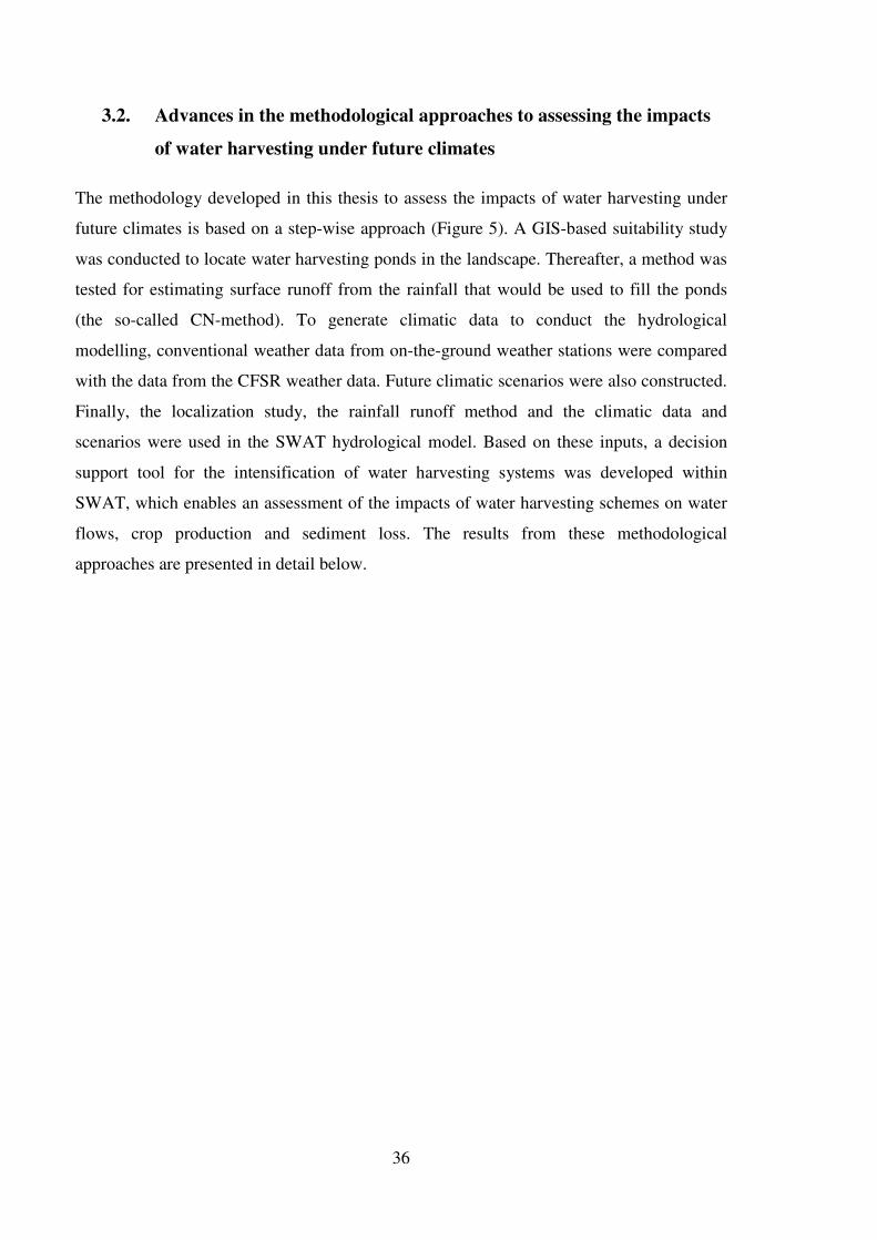
3.2. Advances in the methodological approaches to assessing the impacts of water harvesting under future climates ......................................................................................................................36
3.2.1. Large potential for water harvesting implementation in the Upper Blue Nile Basin .38
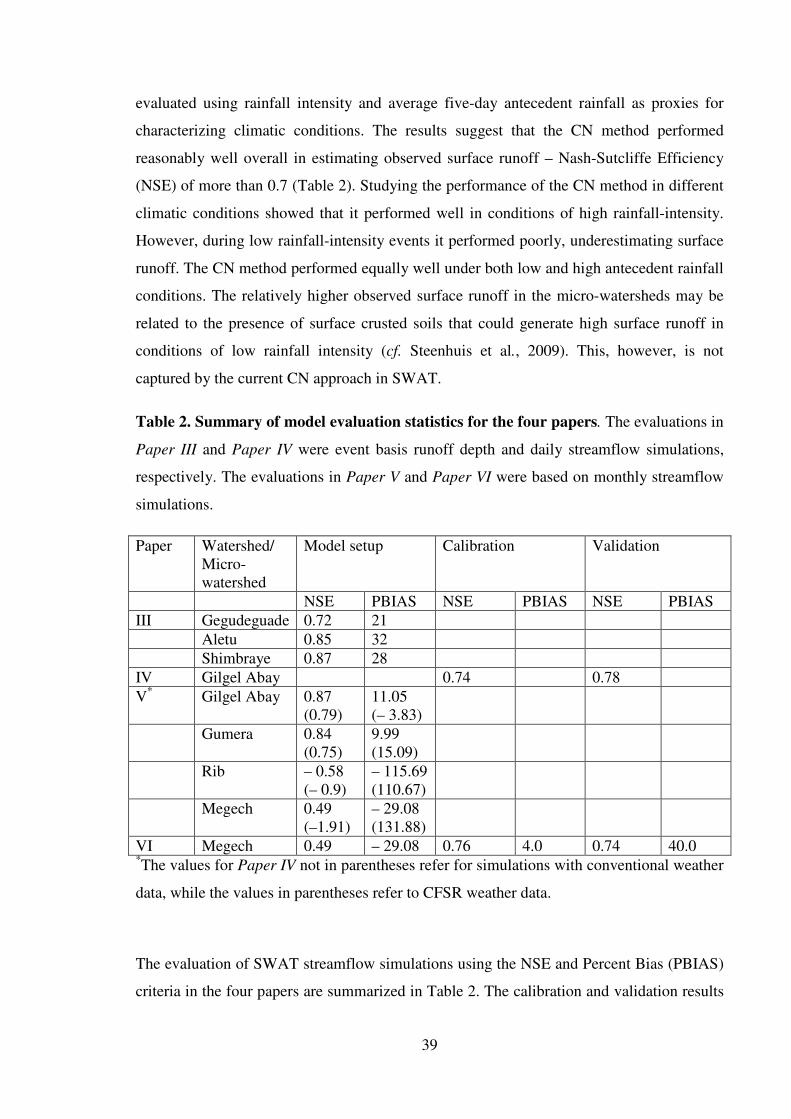
3.2.2. Model performance evaluation...................................................................................38
3.2.3. Emergence of new data can enhance the robustness of hydrological modelling in
data-scarce regions .....................................................................................................................40
3.2.4. A decision support system for the location of water harvesting ponds ......................41
3.3. Implications of climate change and water management interventions ...............................42
3.3.1. Hydrological response to climate change for Gilgel Abay River ..............................42
3.3.2. Implications of the intensification of small-scale water management interventions at a meso-scale watershed in the Lake Tana sub-basin ..................................................................43
4. DISCUSSION ............................................................................................... 46
4.1. Methodological approaches to understanding the implications of water harvesting implementation ...............................................................................................................................46
4.2. Is climate change a challenge or an opportunity? ..............................................................47
4.3. Possible consequences of water harvesting intensification ................................................47
4.4. A framework for the implementation of water harvesting systems ................................... 50
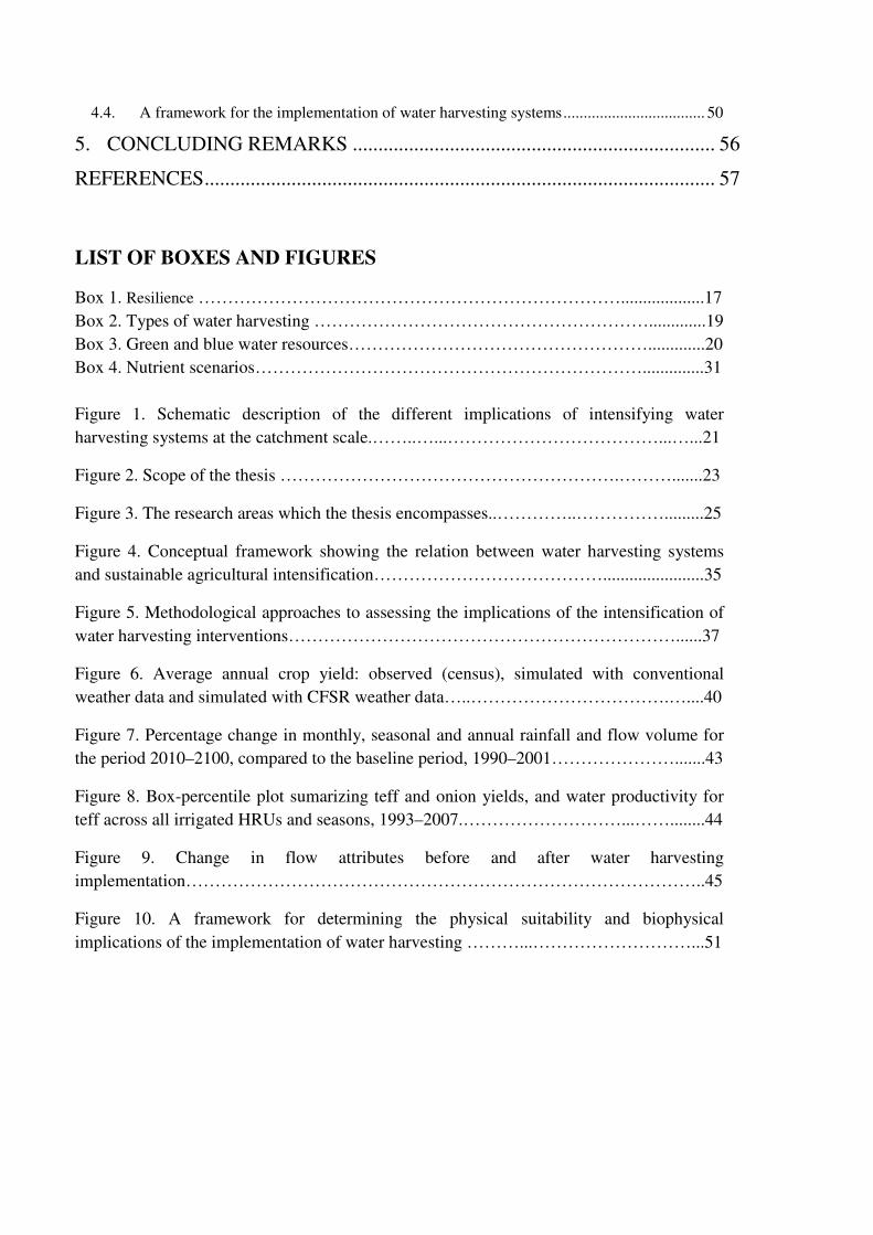
5. CONCLUDING REMARKS ....................................................................... 56
REFERENCES .................................................................................................... 57
LIST OF BOXES AND FIGURES
Box 1. Resilience ………………………………………………………………...................17
Box 2. Types of water harvesting ………………………………………………….............19
Box 3. Green and blue water resources…………………………………………….............20
Box 4. Nutrient scenarios…………………………………………………………..............31
Figure 1. Schematic description of the different implications of intensifying water
harvesting systems at the catchment scale.……..…...………………………………...…...21
Figure 2. Scope of the thesis ………………………………………………….……….......23
Figure 3. The research areas which the thesis encompasses..…………..…………….........25
Figure 4. Conceptual framework showing the relation between water harvesting systems
and sustainable agricultural intensification………………………………….......................35
Figure 5. Methodological approaches to assessing the implications of the intensification of
water harvesting interventions…………………………………………………………......37
Figure 6. Average annual crop yield: observed (census), simulated with conventional
weather data and simulated with CFSR weather data…..…………………………….…....40
Figure 7. Percentage change in monthly, seasonal and annual rainfall and flow volume for
the period 2010–2100, compared to the baseline period, 1990–2001………………….......43
Figure 8. Box-percentile plot sumarizing teff and onion yields, and water productivity for
teff across all irrigated HRUs and seasons, 1993–2007.………………………...……........44
Figure 9. Change in flow attributes before and after water harvesting
implementation……………………………………………………………………………..45
Figure 10. A framework for determining the physical suitability and biophysical
implications of the implementation of water harvesting ………...………………………...51
15
1. INTRODUCTION
1.1. Background
The number and proportion of hungry people in the world is estimated to have declined
(Chen and Ravallion, 2007), but there are still more than 1 billion undernourished people
(FAO, 2010). The majority of these people live in developing countries (WorldBank, 2008;
FAO, 2011). Sub-Saharan Africa takes the lion’s share, and is expected to host ~40% of the
global poor by 2015 (Chen and Ravallion, 2007). The poor in sub-Saharan Africa live in
rural areas (DFID, 2004; IFAD, 2011) and more than 90% of the rural population earns less
than USD 2 per day (IFAD, 2011).
Agriculture plays a key role in the economic portfolios of most developing countries
(DFID, 2004; IFAD, 2011). In sub-Saharan Africa, 40–70% of rural households earn more
than three-quarters of their income from on-farm sources (IFAD, 2011). This clearly
indicates that investment in agriculture can contribute to food security and poverty
reduction for the majority of the rural poor (DFID, 2004; WorldBank, 2008). Various
research across the world (WorldBank, 2008; Thirtle et al., 2001; Gallup et al., 1998; Pretty
et al., 2011) has shown that investment in agriculture can result in a sharp increase in
economic development and poverty reduction.
Agriculture in sub-Saharan Africa is largely rainfed. Rainfed agriculture is the dominant
source of staple food production (Rosegrant et al., 2002; Cooper et al., 2008; FAO, 2011)
and covers 93% of the region’s agricultural area (FAO, 2002; CA, 2007). There is a large
yield gap – between what is actually harvested from farmers’ fields and what could
potentially be achieved – in sub-Saharan agriculture (Singh et al., 2009). For example, in
tropical regions with reliable rainfall and sufficient nutrient application, rainfed commercial
agricultural yield exceeds 5–6 t/ha (Rockström and Falkenmark, 2000; CA, 2007) while the
average rainfed yield in sub-Saharan Africa is less than 1.5 t/ha (Rosegrant et al., 2002b).
The lower level of agricultural production in sub-Saharan Africa is linked to extreme
rainfall variability and the high frequency of dry spells and droughts (Barron et al., 2003;
Rockström et al., 2010) as well as low agricultural inputs such as fertilizer and pesticides
16
(Wichelns, 2003; IAASTD, 2008; Neumann et al., 2010; Rockström et al., 2010; FAO,
2011).
1.2. Rainfed agriculture filled with challenges: will the challenges keep
farmers in the poverty trap or lead them into undesirable regimes?
Current agricultural practices in sub-Saharan Africa are inefficient, vulnerable and
unsustainable. Farms are often too small and fragmented, with low quality soils and high
vulnerability to land degradation (FAO, 2011; IFAD, 2011). The farming systems and
technologies within reach of the farmers generally exhibit low efficiency and dependence
on inputs and techniques that aggravate land degradation and reduce the resilience to
climate variability (FAO, 2011). These challenges lock farmers in a poverty trap (Enfors
and Gordon, 2008) with little or no scope to improve their livelihoods.
Droughts and dry spells are inherent features of the rainfed agriculture in sub-Saharan
Africa (Barron et al., 2003; Fox and Rockstrom, 2003). Climate change is expected to
increase the frequency and intensity of droughts, dry spells and flooding in subtropical
areas (Christensen et al., 2007; IPCC, 2012). Climate change and population pressure will
aggravate the current land degradation process. For example, Arnell (2009) estimates that
with a 4oC average temperature increase in East and Southern Africa, about 35% of current
cropland will become unsuitable for cultivation. This resource degradation will further
exacerbate the vulnerability of social-ecological systems to environmental uncertainties.
This could erode the resilience of the social-ecological system and turn it into an
undesirable regime. The definition of resilience and its importance in the context of sub-
Saharan Africa are outlined in Box 1.
17
Box 1: Resilience
Resilience is a relatively old concept that has evolved over time, and received increased
attention over the past decade. The term was originally conceptualized in the fields of
ecology and systems analysis by Buzz Holling (1973), who defined resilience as the
“measure of the persistence of systems and of their ability to absorb change and
disturbance and still maintain the same relationships between populations or state
variables”. The most recent definition of resilience is defined by Folke et al. (2010) as
the ability of a social-ecological system to deal with change while continuing to develop
(cf Rockström et al., 2014). According to this definition, resilience has three basic
components.
(1) Persistence – the amount of disturbance a system can absorb and still remain
within the same state or domain of attraction;
(2) Adaptability – the degree to which a system is capable of self-organization and
learning while remaining in the same state; and
(3) Transformability – the ability of a system to transform into a new state after
crises or shocks that push the system away from its original stable state.
Thus a resilient social-ecological system has a greater capacity to deal with surprises in
the face of external disturbances, and has a greater capacity to continue to provide goods
and services (Walker and Salt, 2006). Moreover, a resilient social-ecological system has
the potential to create opportunities for reorganization, development and innovation
during disturbance events (Folke, 2003). Social-ecological systems with reduced
resilience may still seem to be in good shape and maintain functions and generate
services (Scheffer et al., 2001; Folke et al., 2004). However, such systems are vulnerable
and when exposed to sudden shocks, a critical threshold may be reached and it may flip
into an undesired state with a reduced capacity to support the functions for the social-
ecological system (Scheffer et al., 2001, 2009; Folke et al., 2004).
For example, in some regions of sub-Saharan Africa, water scarce semi-arid and dry sub-
humid regions have gradually lost social-ecological resilience due to land and water
degradation. … continued next page
18
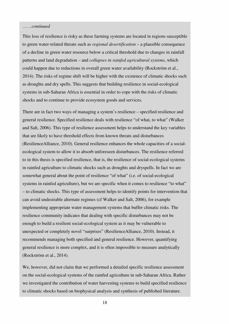
……continued
This loss of resilience is risky as these farming systems are located in regions susceptible
to green water-related threats such as regional desertification – a plausible consequence
of a decline in green water resource below a critical threshold due to changes in rainfall
patterns and land degradation – and collapses in rainfed agricultural systems, which
could happen due to reductions in overall green water availability (Rockström et al.,
2014). The risks of regime shift will be higher with the existence of climatic shocks such
as droughts and dry spells. This suggests that building resilience in social-ecological
systems in sub-Saharan Africa is essential in order to cope with the risks of climatic
shocks and to continue to provide ecosystem goods and services.
There are in fact two ways of managing a system’s resilience – specified resilience and
general resilience. Specified resilience deals with resilience “of what, to what” (Walker
and Salt, 2006). This type of resilience assessment helps to understand the key variables
that are likely to have threshold effects from known threats and disturbances
(ResilienceAlliance, 2010). General resilience enhances the whole capacities of a social-
ecological system to allow it to absorb unforeseen disturbances. The resilience referred
to in this thesis is specified resilience, that is, the resilience of social-ecological systems
in rainfed agriculture to climatic shocks such as droughts and dryspells. In fact we are
somewhat general about the point of resilience “of what” (i.e. of social-ecological
systems in rainfed agriculture), but we are specific when it comes to resilience “to what”
– to climatic shocks. This type of assessment helps to identify points for intervention that
can avoid undesirable alternate regimes (cf Walker and Salt, 2006), for example
implementing appropriate water management systems that buffer climatic risks. The
resilience community indicates that dealing with specific disturbances may not be
enough to build a resilient social-ecological system as it may be vulnerable to
unexpected or completely novel “surprises” (ResilienceAlliance, 2010). Instead, it
recommends managing both specified and general resilience. However, quantifying
general resilience is more complex, and it is often impossible to measure analytically
(Rockström et al., 2014).
We, however, did not claim that we performed a detailed specific resilience assessment
on the social-ecological systems of the rainfed agriculture in sub-Saharan Africa. Rather
we investigated the contribution of water harvesting systems to build specified resilience
to climatic shocks based on biophysical analysis and synthesis of published literature.
19
1.3. Water harvesting: a lifeline for poverty reduction and a dilemma for
downstream social-ecological systems
Research has shown that there are no agro-hydrological limitations to double or triple on-
farm staple food yields in rainfed agriculture in drought prone environments (Rockström et
al., 2002). Inter- and intra-annual rainfall variability are major factors behind low
agricultural productivity. Integrated water management solutions in rainfed agriculture can
therefore result in significant yield improvements (CA, 2007). Water harvesting is
suggested as a key strategy to bridge climatic variability and to increase agricultural
production while balancing the effects on the environment (Pandey, 2001; Rosegrant et al.,
2002a; IAASTD, 2009; Foley et al., 2011; Liniger et al., 2011). There are different types of
water harvesting systems. Box 2 defines the different types, and an extensive list of water
harvesting systems is provided in the literature (Ngigi et al., 2005; Vohland and Barry,
2009; Biazin et al., 2012; Dile et al., 2013).
Water harvesting systems affect green and blue water partitioning at the local scale. This
suggests that intensification of water harvesting at a larger scale could affect overall
Box 2: Types of Water harvesting
Water harvesting systems are generally classified into the in-situ and the ex-situ (Dile et
al., 2013b). Ex-situ water harvesting systems are also called macro-catchment or
external water harvesting systems (Rosegrant et al., 2002a; SEI, 2009; Biazin et al.,
2011). These systems collect water from a large area (Rosegrant et al., 2002a; Oweis and
Hachum, 2006) and have water collection catchment, conveyance and storage structures.
Examples of ex-situ water harvesting systems are tanks, ponds and reservoirs. In-situ
water harvesting systems are practices whereby rainfall is captured and stored where it
falls. Micro-catchment water harvesting systems, which collect water from a relatively
small catchment area (Biazin et al., 2011), are also categorized as in-situ water
harvesting system (Hatibu et al., 2006; SEI, 2009; Vohland and Barry, 2009). In micro-
catchment water harvesting systems, the catchment and cropped area are distinct but
adjacent to each other (Rosegrant et al., 2002a; Hatibu et al., 2006). In-situ water
harvesting systems improve the soil moisture by enhancing infiltration, and reducing
runoff and evaporation (Ngigi et al., 2005; SEI, 2009). Examples of in-situ water
harvesting include pits, fanya juu and bunds.
20
hydrological dynamics. The definitions of the green water and blue water resources, and the
effect of water harvesting in the interplay process are described in Box 3. A synthesis of the
literature on the consequences of intensifying water harvesting at the watershed scale on the
downstream social-ecological systems guides two schools of thought. A few studies have
shown that upgrading rain-fed agriculture through investments in water harvesting systems
may result in negative impacts on downstream social-ecological systems because of a
decrease in runoff generation (e.g. Batchelor et al., 2003; Glendenning and Vervoort, 2011;
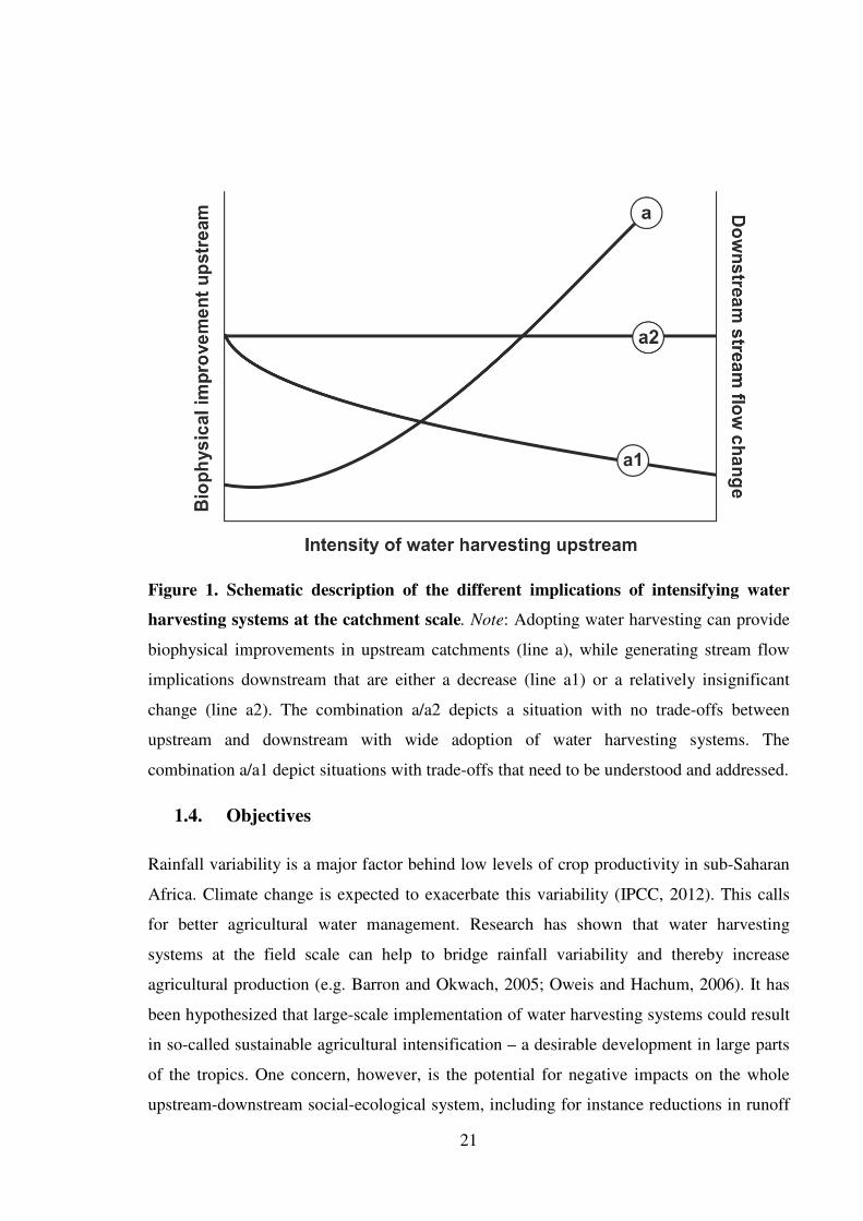
Garg et al., 2012). This is described in the conceptual diagram in Figure 1 as an increase in
crop yield in the upstream areas (line a) and a decrease in stream flow in the downstream
areas (line a1). Other literature (e.g. Schreider et al., 2002; De Winnaar and Jewitt, 2010;
Andersson et al., 2011), by contrast, indicate that wider implementation of water harvesting
upstream has either limited or no downstream impacts on stream flows and aquatic
ecosystems (Figure 1, line a2). This suggests that an increase in water use upstream may
not automatically result in reduced water availability downstream. One possible
explanation is that an increase in water productivity upstream may offset the extra water
tapped upstream (Rockström et al., 2002).
Box 3: Green and blue water resources
Green water resource is the naturally infiltrated rain attached to soil particles and
accessible to roots. Blue water resource is the liquid water in rivers, lakes and aquifers
(Rockström et al., 2009). The distinction between blue water and green water occurs at
the soil surface where rain water is partitioned as surface runoff (blue water), and
infiltrated water and evapotranspiration (green water). The infiltrated water is again
partitioned in the root zone into soil water that will evapotranspire (green water), and
that which percolates deep into the ground water aquifer (blue water). Ex-situ water
harvesting systems store the blue water, which is later used for irrigation to supplement
green water deficiency. This is where a blue-to-green redirection occurs. The vapour
flow that occurs as a result of this process is defined as consumptive blue water use
(Rockström et al., 2009). In-situ water harvesting systems enhance the soil moisture
(green water) in the root zone. This is why in-situ water harvesting systems are often
described as green water management tools. It is possible that the infiltrated soil
moisture (green water) may in the long run percolate into the ground water aquifer or
come out as spring water (blue water). This is the redirection of green-to-blue water. In
this way, water management interventions affect the green-blue interplay.
21
Figure 1. Schematic description of the different implications of intensifying water
harvesting systems at the catchment scale. Note: Adopting water harvesting can provide
biophysical improvements in upstream catchments (line a), while generating stream flow
implications downstream that are either a decrease (line a1) or a relatively insignificant
change (line a2). The combination a/a2 depicts a situation with no trade-offs between
upstream and downstream with wide adoption of water harvesting systems. The
combination a/a1 depict situations with trade-offs that need to be understood and addressed.
1.4. Objectives
Rainfall variability is a major factor behind low levels of crop productivity in sub-Saharan
Africa. Climate change is expected to exacerbate this variability (IPCC, 2012). This calls
for better agricultural water management. Research has shown that water harvesting
systems at the field scale can help to bridge rainfall variability and thereby increase
agricultural production (e.g. Barron and Okwach, 2005; Oweis and Hachum, 2006). It has
been hypothesized that large-scale implementation of water harvesting systems could result
in so-called sustainable agricultural intensification – a desirable development in large parts
of the tropics. One concern, however, is the potential for negative impacts on the whole
upstream-downstream social-ecological system, including for instance reductions in runoff
22
downstream. Lack of well established methods has been one of the challenges to adequately
understanding the upstream-downstream implications of an intensification of water
harvesting. Therefore, this thesis:
1) Explores the capacity of water harvesting systems to contribute to sustainable
agricultural intensification;
2) Develops methods to estimate the hydrological processes in a tropical landscape
in the light of future climates, identify suitable areas for water harvesting, and
integrate water harvesting systems into the hydrological models and
subsequently capture their impacts
3) Assesses the impacts of global environmental change on hydrological processes
in the case study area, and of the implementation of large-scale water harvesting
on upstream-downstream opportunities and trade-offs
1.5. Organization of the thesis
The thesis tries to understand the implications of environmental changes, and integrated
watershed development and management decisions on social-ecological systems -- with
emphasis on biophysical assessments -- in the rainfed agriculture of sub-Saharan Africa.
The thesis consists of six papers. Figure 2 shows the linkages among the papers and how
they address the overarching objectives. Paper I investigates both endogenous and
exogenous drivers that call for changes to the rainfed agriculture in sub-Saharan Africa. It
explores the role of water harvesting in achieving sustainable agricultural intensification
and building specified resilience against water-related shocks. Biophysical analysis using
hydrological models can provide insight into how intensification of water harvesting
systems might unfold on the upstream-downstream social-ecological systems. However,
this entails identifying suitable areas where water harvesting systems should be
implemented. Paper II assesses suitable areas for water harvesting implementation in a
basin in sub-Saharan Africa. There is growing concern that since surface runoff estimation
methods in most hydrological models originate from temperate regions, they may not
accurately estimate surface runoff in sub-Saharan Africa. For example, the Curve Number
method, which is widely used in most hydrological models, is often criticized for not
appropriately estimating surface runoff in tropical climates. Paper III, therefore,
investigates the applicability of the Curve Number method to surface runoff estimation in
tropical climatic regions. Paper IV covers model set-up, calibration and validation when
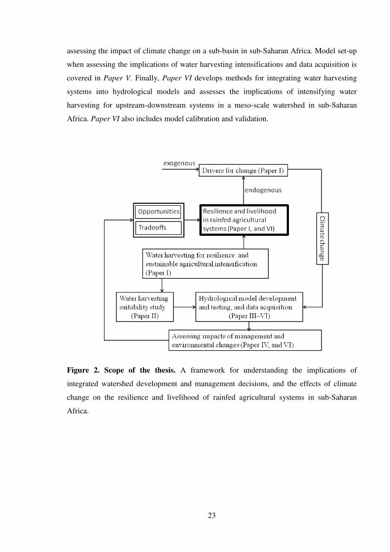
assessing the impact of climate change on a sub
when assessing the implications of water harvesting intensifications and data acquisition
covered in Paper V. Finally,
systems into hydrological models and assesses the implications of intensifying water
harvesting for upstream
Africa. Paper VI also includes model calibration and validation.
Figure 2. Scope of the
integrated watershed development and management decisions, and the effects of climate
change on the resilience and livelih
Africa.
23
t of climate change on a sub-basin in sub-Saharan Africa. Model set
when assessing the implications of water harvesting intensifications and data acquisition
. Finally, Paper VI develops methods for integrating water harvesting
ems into hydrological models and assesses the implications of intensifying water
am-downstream systems in a meso-scale watershed in sub
also includes model calibration and validation.
Figure 2. Scope of the thesis. A framework for understanding the implications of
integrated watershed development and management decisions, and the effects of climate
change on the resilience and livelihood of rainfed agricultural systems
Saharan Africa. Model set-up
when assessing the implications of water harvesting intensifications and data acquisition is
develops methods for integrating water harvesting
ems into hydrological models and assesses the implications of intensifying water
scale watershed in sub-Saharan
A framework for understanding the implications of
integrated watershed development and management decisions, and the effects of climate
al systems in sub-Saharan
24
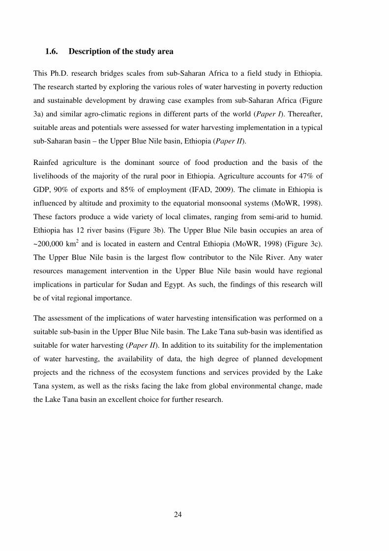
1.6. Description of the study area
This Ph.D. research bridges scales from sub-Saharan Africa to a field study in Ethiopia.
The research started by exploring the various roles of water harvesting in poverty reduction
and sustainable development by drawing case examples from sub-Saharan Africa (Figure
3a) and similar agro-climatic regions in different parts of the world (Paper I). Thereafter,
suitable areas and potentials were assessed for water harvesting implementation in a typical
sub-Saharan basin – the Upper Blue Nile basin, Ethiopia (Paper II).
Rainfed agriculture is the dominant source of food production and the basis of the
livelihoods of the majority of the rural poor in Ethiopia. Agriculture accounts for 47% of
GDP, 90% of exports and 85% of employment (IFAD, 2009). The climate in Ethiopia is
influenced by altitude and proximity to the equatorial monsoonal systems (MoWR, 1998).
These factors produce a wide variety of local climates, ranging from semi-arid to humid.
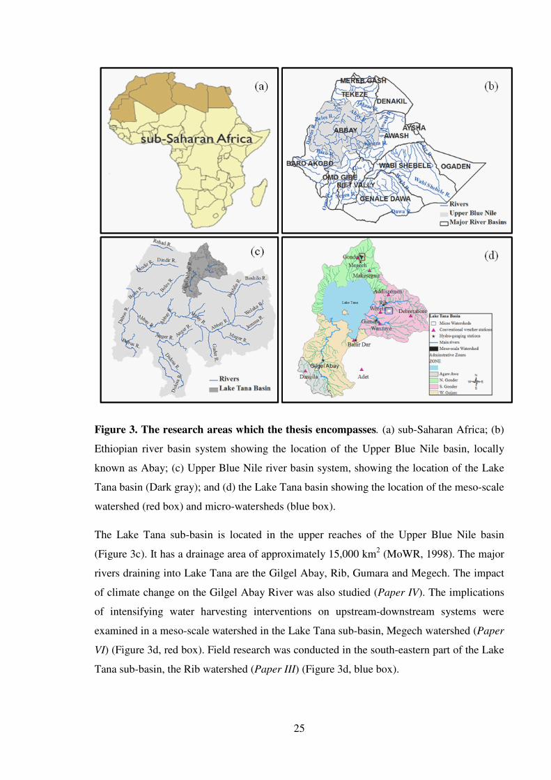
Ethiopia has 12 river basins (Figure 3b). The Upper Blue Nile basin occupies an area of
~200,000 km2 and is located in eastern and Central Ethiopia (MoWR, 1998) (Figure 3c).
The Upper Blue Nile basin is the largest flow contributor to the Nile River. Any water
resources management intervention in the Upper Blue Nile basin would have regional
implications in particular for Sudan and Egypt. As such, the findings of this research will
be of vital regional importance.
The assessment of the implications of water harvesting intensification was performed on a
suitable sub-basin in the Upper Blue Nile basin. The Lake Tana sub-basin was identified as
suitable for water harvesting (Paper II). In addition to its suitability for the implementation
of water harvesting, the availability of data, the high degree of planned development
projects and the richness of the ecosystem functions and services provided by the Lake
Tana system, as well as the risks facing the lake from global environmental change, made
the Lake Tana basin an excellent choice for further research.
25
Figure 3. The research areas which the thesis encompasses. (a) sub-Saharan Africa; (b)
Ethiopian river basin system showing the location of the Upper Blue Nile basin, locally
known as Abay; (c) Upper Blue Nile river basin system, showing the location of the Lake
Tana basin (Dark gray); and (d) the Lake Tana basin showing the location of the meso-scale
watershed (red box) and micro-watersheds (blue box).
The Lake Tana sub-basin is located in the upper reaches of the Upper Blue Nile basin
(Figure 3c). It has a drainage area of approximately 15,000 km2 (MoWR, 1998). The major
rivers draining into Lake Tana are the Gilgel Abay, Rib, Gumara and Megech. The impact
of climate change on the Gilgel Abay River was also studied (Paper IV). The implications
of intensifying water harvesting interventions on upstream-downstream systems were
examined in a meso-scale watershed in the Lake Tana sub-basin, Megech watershed (Paper
VI) (Figure 3d, red box). Field research was conducted in the south-eastern part of the Lake
Tana sub-basin, the Rib watershed (Paper III) (Figure 3d, blue box).
26
2. MATERIALS and METHODS
2.1. Data
This Ph.D. thesis began with conceptual framework development on the role of water
harvesting in the implementation of sustainable agricultural intensification and building
resilience against risks of climatic shocks. Systematically collected evidence from the
existing literature was used to draw lessons and conclusions (Paper I). The thesis,
thereafter, implemented spatial analysis and hydrological modelling to understand the
effects of the intensification of water harvesting on upstream-downstream social-ecological
systems.
The spatial analysis and hydrological modelling were based on primary and secondary data
sources. The datasets used for each of the six papers are presented in Table 1. The Shuttle
Radar Topographic Mission (SRTM) DEM data have a resolution of 90 m by 90 m, and
were obtained from the CGIAR Consortium for Spatial Information website (CGIAR-CSI,
2009). The stream network, land use and soil data have a scale of 1:250,000 (BCEOM,
1998) and were obtained from the Ethiopian Ministry of Water Resources (MoWR, 2009).
The physical and chemical property parameters of the soil, which were required by SWAT,
were derived from the Africa map sheet of the 1995 CD-ROM edition of the Soil Map of
the World (FAO, 1995).
The rainfall data for Paper II were obtained from WorldClim-Global Climate Data
(WorldClim, 2009). Three weather data sources were used in this study: primary weather
(Paper III); observed weather from climatic stations in and around the Lake Tana basin,
hereafter called “conventional weather data” (Paper III–VI); and weather data from the
National Center for Environmental Prediction’s Climate Forecast System Reanalysis (Saha
et al., 2010), hereafter called “CFSR weather data” (Paper V). The conventional weather
data were obtained from the Ethiopian National Meteorological Services Agency (ENMSA,
2012), and the CFSR weather data were obtained from the Texas A&M University Spatial
Sciences Laboratory website, globalweather.tamu.edu (Globalweather, 2012).
27
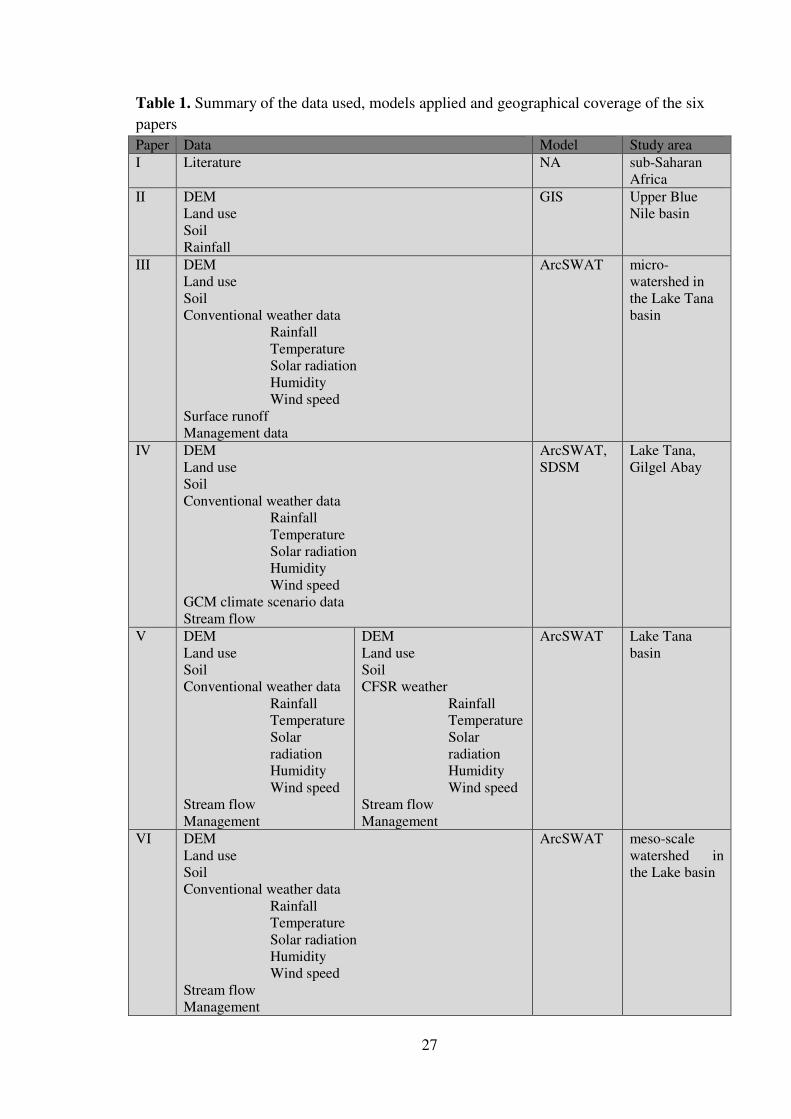
Table 1. Summary of the data used, models applied and geographical coverage of the six
papers Paper Data Model Study area I Literature NA sub-Saharan
Africa II DEM
Land use Soil Rainfall
GIS Upper Blue Nile basin
III DEM Land use Soil Conventional weather data
Rainfall Temperature Solar radiation Humidity Wind speed
Surface runoff Management data
ArcSWAT micro-watershed in the Lake Tana basin
IV DEM Land use Soil Conventional weather data
Rainfall Temperature Solar radiation Humidity Wind speed
GCM climate scenario data Stream flow
ArcSWAT, SDSM
Lake Tana, Gilgel Abay
V DEM Land use Soil Conventional weather data
Rainfall Temperature Solar radiation Humidity Wind speed
Stream flow Management
DEM Land use Soil CFSR weather
Rainfall Temperature Solar radiation Humidity Wind speed
Stream flow Management
ArcSWAT Lake Tana basin
VI DEM Land use Soil Conventional weather data
Rainfall Temperature Solar radiation Humidity Wind speed
Stream flow Management
ArcSWAT meso-scale watershed in the Lake basin
28
Large scale (predictor) and local (predictand) climate variables were important in the
climate change studies (Paper IV). The predictor variables were obtained from the National
Center for Environmental Prediction (NCEP_1961-2001) reanalysis data set for the
calibration and validation, and the Hadley Centre Climate Model 3 (HadCM3) GCM
(H3A2a_1961–2099 and H3B2a_1961–2099) data for the baseline and climate scenario
periods 1961–2099 (Canada, 2009). The predictand variables used were precipitation and
maximum and minimum temperature at Dangila station (Figure 3), and the data were
obtained from the Ethiopian National Meteorological Services Agency (ENMSA, 2012).
The A2 (medium-high) and B2 (medium-low) emission scenarios of the IPCC Special
Report on Emission Scenarios for the period 1961–2100 (Wilby and Harris, 2006; Kim and
Kaluarachchi, 2009) were used to generate the future precipitation and temperature
scenarios.
The stream flow data were obtained from the Ethiopian Ministry of Water and Energy
(MoWE, 2012). Surface runoff was observed at three micro-watersheds in the Lake Tana
basin using 2.5 H-flumes. A combination of manual and automatic stage recorders was
used (the Stage Discharge Recorder, SDR-0001-1, from the Sutron Corporation and the
Schlumberger Micro-diver). The Lake Tana elevation-area-volume curve from Wale et al.
(2009) and Angereb reservoir data from the municipal water supply authority for Gondor
town (GWSA, 2012) were used as input for the reservoirs in SWAT. Data on agricultural
management practices were obtained from the Ethiopian Institute of Agricultural Research
(EIAR, 2007), the Ethiopian Central Statistical Agency (CSA, 2012) and from field
observations.
2.2. Modelling approach
2.2.1. Multi-criteria evaluation for water harvesting suitability
The adoption of water harvesting systems to build resilience in farming systems requires
detailed assessment and analysis of suitability for water harvesting. Water harvesting
suitability assessments enable estimation of the potential of a region to benefit from water
harvesting implementation, and can identify priority areas for water harvesting
implementation. The suitability for water harvesting of the Upper Blue Nile Basin in
Ethiopia was determined using two GIS-based Multi-Criteria Evaluation (MCE) methods.
The Boolean approach was applied to locate suitable areas for in-situ and ex-situ water
29
harvesting systems, while weighted overlay analysis was used to classify the suitable areas
into different water harvesting suitability levels. The criteria for identifying the suitable
areas for water harvesting were based on recommendations in the literature (e.g. Critchley
and Siegert, 1991; FAO, 1995, 2006; Mati et al., 2006; Mbilinyi et al., 2007; Kahinda et al.,
2008).
2.2.2. Hydrological modelling
The hydrological modelling for studying the implications of climate change and agriculture
water management interventions was performed using the SWAT model. SWAT is a
physically based model that can simulate hydrological cycles, vegetation growth and
nutrient cycling using a daily time-step by disaggregating a river basin into sub-basins and
hydrological response units (HRUs). HRUs are lumped land areas within the sub-basin that
represent unique land cover, soil and management combinations. The model can predict the
impact of land management practices such as fertilizer application and irrigation on water,
sediment, agricultural chemical yields and crop production (Neitsch et al., 2012). The
outputs from SWAT can be post-processed and used to determine the impacts of various
management decisions on upstream-downstream social-ecological systems.
Various studies comparing SWAT with other biophysical models indicate that SWAT has
better capabilities for hydrological applications. Borah and Bera (2003) compared SWAT
with the Dynamic Watershed Simulation Model (DWSM), Hydrologic Simulation
Program-Fortran (HSPF), Système Hydrologique Européen (MIKE SHE), Annualized
AGricultural Non-Point Source (AnnAGNPS), and six other models that simulate
hydrology, sediment and chemical inputs. The study concludes that SWAT is a promising
model for continuous simulations in predominantly agricultural watersheds. Other studies
have shown that SWAT simulations are better than HSPF simulations in different
watersheds in the United States (Van et al., 2003; Saleh and Du, 2004; Singh et al., 2005).
SWAT estimates flow more accurately than the Soil Moisture Distribution and Routing
(SMDR) model in an experimental watershed in east-central Pennsylvania (Srinivasan et
al., 2005). Parajuli et al. (2009) applied AnnAGNPS and SWAT to evaluate flow and water
quality in the Cheney Lake watershed in south-central Kansas. They concluded that SWAT
was the most appropriate model for this watershed. SWAT and MIKE-SHE simulated the
hydrology of Belgium’s Jeker River basin in an acceptable way (El-Nasr et al., 2005).
Vigerstol and Aukema (2011) found SWAT and variable infiltration capacity (VIC) two of
30
the most useful tools for modelling freshwater ecosystem services. VIC is a macro scale
hydrological model that is most appropriate for large river basins where stream flow is the
main variable of interest (Vigerstol and Aukema, 2011). Trambauer et al. (2013) reviewed
16 well-known hydrological and land surface models for hydrological drought forecasting
in Africa. They chose SWAT from among the five models that show the biggest potential
and most suitability for that purpose. The other four models have more global scale
applications. SWAT has been applied in the highlands of Ethiopia and demonstrated
satisfactory performance (Easton et al., 2010; Setegn et al., 2010; Betrie et al., 2011; Dile et
al., 2013a). SWAT is freely available, has a user friendly interface and active support, and
can be easily linked to sensitivity, calibration and uncertainty analysis tools (cf. van
Griensven et al., 2012). These capabilities therefore made SWAT an appealing choice for
this research.
The SWAT model was set up in the mico-watershed (Paper III), the meso-scale watershed
(Paper VI) and the entire Lake Tana basin (Paper IV and Paper V). SWAT model
calibration and validation were performed for Paper IV and Paper VI. Paper IV and Paper
VI studied the impact on biophysical systems of climate change and management
interventions, respectively. Before any model is used for such purposes its applicability
should be verified using calibration and validation processes. Thus, model calibration of the
hydrological parameters for Paper IV and Paper VI was based on the Parasol (van
Griensven and Bauwens, 2003) and Sequential Uncertainty Fitting version 2 (SUFI-2)
(Abbaspour et al., 2004, 2007) algorithms, respectively. Model calibration was not
performed for Paper III and Paper V. Paper III aimed to study the usefulness of the CN
method for estimating surface runoff in given soil, land use and management conditions,
and therefore parameter manipulation, such as CN adjustment, was not necessary. Paper V
tested the applicability of the CFSR climate data for hydrological predictions by comparing
the streamflow simulations in the CFSR climate data and the conventional climate data
with the observed streamflow. Calibration is not important for this type of study as the
purpose of calibration is to improve the performance of the model for a given climatic
input.
Paper VI developed a decision support system that identifies suitable areas for water
harvesting, and determines the corresponding size of the water harvesting ponds for each
suitable field. The decision support system calculates the amount of water required to
31
irrigate each suitable field for double cropping (teff during rainy periods and onion during
dry periods), as well as the amount of evaporation from the “preliminary” water harvesting
pond. It also calculates the amount of flow into each of the water harvesting ponds and
checks whether there is sufficient flow to meet these water requirements (i.e. irrigation
water requirements and evaporation from the ponds). If the amount of flow into each of the
water harvesting ponds is sufficient for these water requirements, it adopts the
“preliminary” pond dimensions. If not, it updates the area to be irrigated so that it can be
covered by the available water flow, and redesigns the dimensions of the water harvesting
pond accordingly. The decision support system considers the maximum pond dimension
that meets water requirement for the extreme climatic and management conditions.
Thereafter, the water harvesting systems are integrated into the SWAT model, and nutrient
application scenarios based on existing farming practice and government recommendations
implemented (see Box 4). The biophysical systems of a meso-scale watershed in the Lake
Tana basin were analysed before and after water harvesting and various nutrient scenario
implementations in order to understand their effects on upstream-downstream social-
ecological systems.
Box 4: Nutrient scenarios
Baseline nutrient application
� Teff: Planting: 15 kg/ha urea, 30 kg/ha DAP; side dress: 15 kg/ha urea
� Onion: 85 kg/ha urea, 30 kg/ha DAP; side dress: 85 kg/ha Urea
Blanket Nutrient Recommendation (BNR1)
� Teff: Planting: 50 kg/ha urea, 30 kg/ha DAP; side dress: 50 kg/ha urea
� Onion: 85 kg/ha urea, 30 kg/ha DAP; side dress: 85 kg/ha urea
Blanket Nutrient Recommendation (BNR2)
� Teff: Planting: 85 kg/ha urea, 30 kg/ha DAP; side dress: 85 kg/ha urea
� Onion: 85 kg/ha urea, 30 kg/ha DAP; side dress: 85 kg/ha urea
32
2.2.3. Curve Number Method investigated for estimating surface runoff in
tropical watersheds
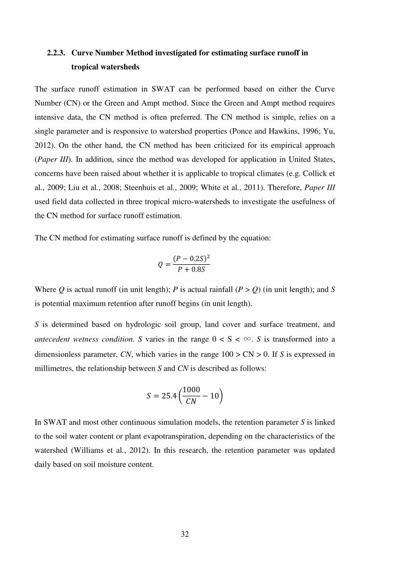
The surface runoff estimation in SWAT can be performed based on either the Curve
Number (CN) or the Green and Ampt method. Since the Green and Ampt method requires
intensive data, the CN method is often preferred. The CN method is simple, relies on a
single parameter and is responsive to watershed properties (Ponce and Hawkins, 1996; Yu,
2012). On the other hand, the CN method has been criticized for its empirical approach
(Paper III). In addition, since the method was developed for application in United States,
concerns have been raised about whether it is applicable to tropical climates (e.g. Collick et
al., 2009; Liu et al., 2008; Steenhuis et al., 2009; White et al., 2011). Therefore, Paper III
used field data collected in three tropical micro-watersheds to investigate the usefulness of
the CN method for surface runoff estimation.
The CN method for estimating surface runoff is defined by the equation:
� = �� − 0.2�� + 0.8
Where Q is actual runoff (in unit length); P is actual rainfall (P > Q) (in unit length); and S
is potential maximum retention after runoff begins (in unit length).
S is determined based on hydrologic soil group, land cover and surface treatment, and
antecedent wetness condition. S varies in the range 0 < S < ∞. S is transformed into a
dimensionless parameter, CN, which varies in the range 100 > CN > 0. If S is expressed in
millimetres, the relationship between S and CN is described as follows:
= 25.4 �1000�� − 10�
In SWAT and most other continuous simulation models, the retention parameter S is linked
to the soil water content or plant evapotranspiration, depending on the characteristics of the
watershed (Williams et al., 2012). In this research, the retention parameter was updated
daily based on soil moisture content.
33
2.2.4. Statistical Downscaling Approach
Global Circulation Model (GCM) derived scenarios of climate change were used to predict
the future climates of the study area as they conform to the criteria proposed by the
Intergovernmental Panel on Climate Change (IPCC). The GCM data, however, are too
coarse in resolution to apply directly to impact assessment (Mearns et al., 2003). The
Statistical Downscaling Tool (SDSM) was used to downscale the HadCM3 GCM scenario
data into finer scale resolution. The SDSM develops statistical relationships, based on
multiple linear regression techniques, between large-scale (predictors) and local
(predictand) climate. The downscaling of GCM data using SDSM was carried out
following the procedures suggested by Wilby and Dawson (2007). The climate projection
analysis was carried out by dividing the period 2010–2100 into three time windows, each
with 30 years of data centred at 2025 (2010–2039), 2055 (2040–2069) and 2085 (2070–
2100). The period 1990–2001 was taken as the baseline period against which comparison
was made. SDSM downscaled climate outputs were used as an input to the SWAT model to
assess the impact of climate change.
34
3. RESULTS
3.1. Water harvesting can help to achieve sustainable agricultural
intensification and specified resilience against climatic shocks
We studied the state of agriculture in sub-Saharan Africa and its link to poverty. The
drivers for change that aggravate the current challenges facing agriculture in the region
were explored, and potential solutions were proposed from a water management
perspective. We demonstrated conceptually that agricultural intensification with water
harvesting systems can contribute to sustainable agricultural systems through productivity
improvements, sustaining ecosystem functions in agricultural landscapes and building
higher resilience by keeping the agroecosystems in a productive state with increased ability
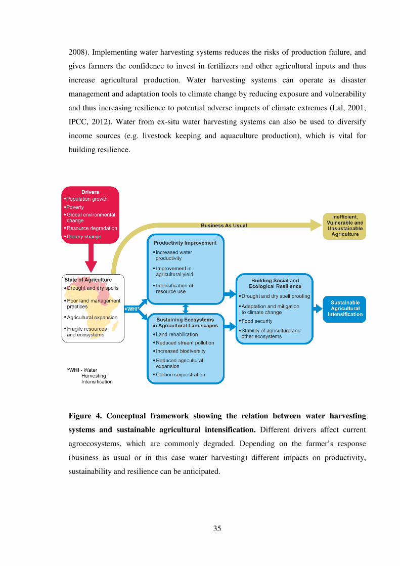
to withstand shocks (Figure 4).
A large part of the rainfall (~70–85% of the rainfall depending on the land management
conditions) in arid and semi-arid regions in much of sub-Saharan Africa is lost as
unproductive evaporation, percolation and runoff from the farmer’s field (Rockstrom et al.,
2002). Various research (e.g. Oweis and Hachum, 2006; Pretty et al., 2006; Molden et al.,
2010) has shown that water harvesting (both ex-situ and in-situ) systems can increase
agricultural productivity in rainfed agriculture by producing “more crops per drop” of rain.
Water harvesting with better nutrient application can further improve productivity (Jensen
et al., 2003; Zougmoré et al., 2003; Barron and Okwach, 2005; Fatondji et al., 2006).
Water harvesting systems can sustain ecosystems in agricultural landscapes by limiting
agricultural expansion (Lal, 2001; Reij et al., 2009; Vohland and Barry, 2009), restoring
degraded landscapes (Lal, 2001; Reij et al., 2009; Vohland and Barry, 2009), improving
biodiversity (Pandey, 2001; Reij et al., 2009; Vohland and Barry, 2009; Norfolk et al.,
2012) and limiting soil erosion and nutrient leakage from fields (Herweg and Ludi, 1999;
Braskerud, 2002; Gebremichael et al., 2005; McHugh et al., 2007; Gebreegziabher et al.,
2009). By limiting soil erosion and nutrient leakage, water harvesting systems can improve
water quality, thereby enhancing the health of the aquatic environment.
Water harvesting systems can build resilience in dry-land agricultural systems by securing
adequate water availability, enhancing plant water uptake capacity, improving soil nutrient
availability and building natural capital in agroecosystems (Falkenmark and Rockström,
35
2008). Implementing water harvesting systems reduces the risks of production failure, and
gives farmers the confidence to invest in fertilizers and other agricultural inputs and thus
increase agricultural production. Water harvesting systems can operate as disaster
management and adaptation tools to climate change by reducing exposure and vulnerability
and thus increasing resilience to potential adverse impacts of climate extremes (Lal, 2001;
IPCC, 2012). Water from ex-situ water harvesting systems can also be used to diversify
income sources (e.g. livestock keeping and aquaculture production), which is vital for
building resilience.
Figure 4. Conceptual framework showing the relation between water harvesting
systems and sustainable agricultural intensification. Different drivers affect current
agroecosystems, which are commonly degraded. Depending on the farmer’s response
(business as usual or in this case water harvesting) different impacts on productivity,
sustainability and resilience can be anticipated.
36
3.2. Advances in the methodological approaches to assessing the impacts
of water harvesting under future climates
The methodology developed in this thesis to assess the impacts of water harvesting under
future climates is based on a step-wise approach (Figure 5). A GIS-based suitability study
was conducted to locate water harvesting ponds in the landscape. Thereafter, a method was
tested for estimating surface runoff from the rainfall that would be used to fill the ponds
(the so-called CN-method). To generate climatic data to conduct the hydrological
modelling, conventional weather data from on-the-ground weather stations were compared
with the data from the CFSR weather data. Future climatic scenarios were also constructed.
Finally, the localization study, the rainfall runoff method and the climatic data and
scenarios were used in the SWAT hydrological model. Based on these inputs, a decision
support tool for the intensification of water harvesting systems was developed within
SWAT, which enables an assessment of the impacts of water harvesting schemes on water
flows, crop production and sediment loss. The results from these methodological
approaches are presented in detail below.
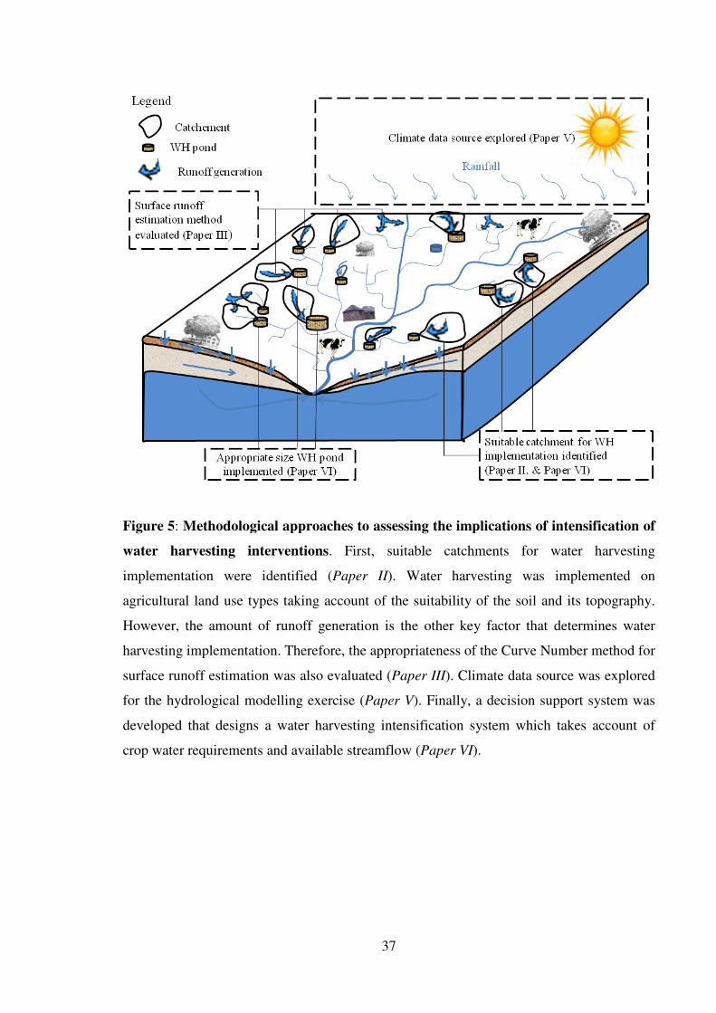
Figure 5: Methodological approaches to assess
water harvesting interventions
implementation were identified (
agricultural land use types
However, the amount of runoff generation is the other key factor that determines water
harvesting implementation. Therefore, the appropriateness of the Curve Number method for
surface runoff estimation was
for the hydrological model
developed that designs
crop water requirements
37
Methodological approaches to assessing the implications of intensification
water harvesting interventions. First, suitable catchments for water harvesting
implementation were identified (Paper II). Water harvesting was implemented on
agricultural land use types taking account of the suitability of the soil and its topography.
However, the amount of runoff generation is the other key factor that determines water
harvesting implementation. Therefore, the appropriateness of the Curve Number method for
surface runoff estimation was also evaluated (Paper III). Climate data
for the hydrological modelling exercise (Paper V). Finally, a decision support system
that designs a water harvesting intensification system which
s and available streamflow (Paper VI).
implications of intensification of
, suitable catchments for water harvesting
). Water harvesting was implemented on
the suitability of the soil and its topography.
However, the amount of runoff generation is the other key factor that determines water
harvesting implementation. Therefore, the appropriateness of the Curve Number method for
data source was explored
). Finally, a decision support system was
which takes account of
38
3.2.1. Large potential for water harvesting implementation in the Upper Blue Nile
Basin
We showed that a large part of the Upper Blue Nile basin was suitable for the
implementation of water harvesting. The Boolean analysis showed that in-situ water
harvesting systems could be successfully implemented in the eastern and the northern part
of the basin, while the ex-situ systems could be applicable in most areas in the basin, in
particular in the central and eastern parts. According to the Boolean analysis, 36% of the
basin is suitable for in-situ and ex-situ systems. The results of the weighted overlay analysis
indicate that the spatial distribution of the suitable areas for water harvesting varies based
on the percentage value of influence assigned to the constraining factors. For example, for
an equal percentage influence of all the determining factors (i.e. rainfall, slope, soil and
land use each have 25% influence), the areas around the Lake Tana region and the south-
eastern part of the basin were classified as highly suitable for water harvesting. The north-
eastern and western parts of the basin were found to be moderately suitable for water
harvesting. We found that 24% of the basin was classified as highly suitable, 58%
moderately suitable and 17% less suitable for water harvesting implementation with an
equal percentage influence for all the determining factors. Around 1% of the area was
excluded from the analysis as it was covered by water bodies, marshland or urban areas,
which were not conducive to water harvesting implementation.
Suitability for water harvesting was highly sensitive to rainfall amount, which suggests that
changes in rainfall (e.g. due to climate change) will alter the results of this study. We
studied water harvesting for crop production. Grazing lands and other land use types were
excluded in the case of the Boolean analysis, and given less priority in the case of weighted
overlay analysis. This could have increased the area suitable areas for water harvesting in
the studied basin but, given the other ecosystem services these land use types provide, we
put a higher priority on the agricultural land use type.
3.2.2. Model performance evaluation
The applicability of the CN method to estimating surface runoff in tropical regions was
investigated by comparing observed surface runoff in three micro-watersheds in the Lake
Tana basin with that of the simulated surface runoff (Paper III). Moreover, the strengths
and weaknesses of the method for estimating surface runoff in tropical regions were
39
evaluated using rainfall intensity and average five-day antecedent rainfall as proxies for
characterizing climatic conditions. The results suggest that the CN method performed
reasonably well overall in estimating observed surface runoff – Nash-Sutcliffe Efficiency
(NSE) of more than 0.7 (Table 2). Studying the performance of the CN method in different
climatic conditions showed that it performed well in conditions of high rainfall-intensity.
However, during low rainfall-intensity events it performed poorly, underestimating surface
runoff. The CN method performed equally well under both low and high antecedent rainfall
conditions. The relatively higher observed surface runoff in the micro-watersheds may be
related to the presence of surface crusted soils that could generate high surface runoff in
conditions of low rainfall intensity (cf. Steenhuis et al., 2009). This, however, is not
captured by the current CN approach in SWAT.
Table 2. Summary of model evaluation statistics for the four papers. The evaluations in
Paper III and Paper IV were event basis runoff depth and daily streamflow simulations,
respectively. The evaluations in Paper V and Paper VI were based on monthly streamflow
simulations.
Paper Watershed/ Micro-watershed
Model setup Calibration Validation
NSE PBIAS NSE PBIAS NSE PBIAS III Gegudeguade 0.72 21 Aletu 0.85 32 Shimbraye 0.87 28 IV Gilgel Abay 0.74 0.78 V* Gilgel Abay 0.87
(0.79) 11.05 (– 3.83)
Gumera 0.84 (0.75)
9.99 (15.09)
Rib – 0.58 (– 0.9)
– 115.69 (110.67)
Megech 0.49 (–1.91)
– 29.08 (131.88)
VI Megech 0.49 – 29.08 0.76 4.0 0.74 40.0 *The values for Paper IV not in parentheses refer for simulations with conventional weather
data, while the values in parentheses refer to CFSR weather data.
The evaluation of SWAT streamflow simulations using the NSE and Percent Bias (PBIAS)
criteria in the four papers are summarized in Table 2. The calibration and validation results
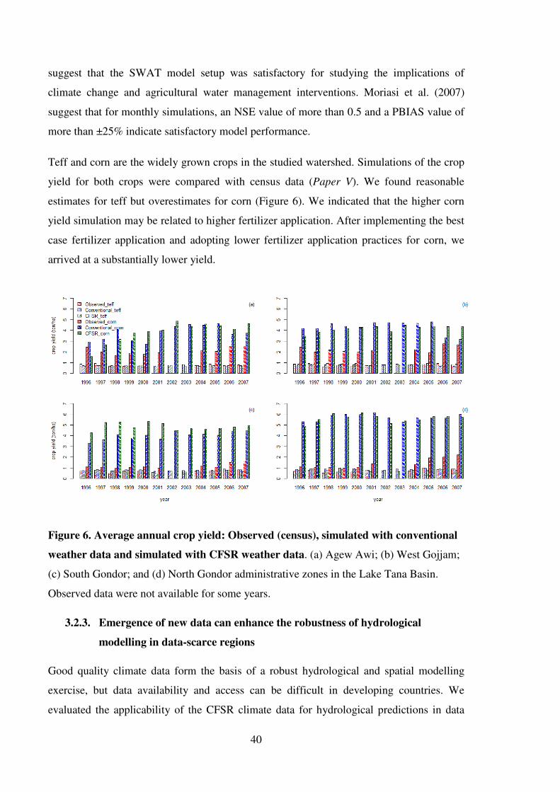
40
suggest that the SWAT model setup was satisfactory for studying the implications of
climate change and agricultural water management interventions. Moriasi et al. (2007)
suggest that for monthly simulations, an NSE value of more than 0.5 and a PBIAS value of
more than ±25% indicate satisfactory model performance.
Teff and corn are the widely grown crops in the studied watershed. Simulations of the crop
yield for both crops were compared with census data (Paper V). We found reasonable
estimates for teff but overestimates for corn (Figure 6). We indicated that the higher corn
yield simulation may be related to higher fertilizer application. After implementing the best
case fertilizer application and adopting lower fertilizer application practices for corn, we
arrived at a substantially lower yield.
Figure 6. Average annual crop yield: Observed (census), simulated with conventional
weather data and simulated with CFSR weather data. (a) Agew Awi; (b) West Gojjam;
(c) South Gondor; and (d) North Gondor administrative zones in the Lake Tana Basin.
Observed data were not available for some years.
3.2.3. Emergence of new data can enhance the robustness of hydrological
modelling in data-scarce regions
Good quality climate data form the basis of a robust hydrological and spatial modelling
exercise, but data availability and access can be difficult in developing countries. We
evaluated the applicability of the CFSR climate data for hydrological predictions in data
41
scarce regions in a case study in the Lake Tana basin. Comparisons between the stream
flow simulations using the conventional weather data and the CFSR weather data showed
that the conventional weather data performed better. However, water balance components
between the conventional weather data and the CFSR weather data were not substantially
different, except at one watershed. Both weather data provided similar annual crop yield
results.
Since the Lake Tana basin is located in a relatively data-rich region in the Upper Blue Nile
basin, it was not surprising that the simulations using the conventional weather data
performed better than the CFSR weather data. The results, however, suggest that in data-
scarce regions such as remote parts of the Upper Blue Nile basin, where conventional
gauges are not available, CFSR weather data could be a valuable option for hydrological
predictions. Moreover, CFSR weather data has an advantage over conventional weather
data in that it provides complete sets of climatic data (i.e. including wind speed, relative
humidity and solar radiation in addition to rainfall and temperature). This provides the
flexibility to use different functions pertaining to hydrological models, which suggests that
the emergence of new data can make hydrological modelling and water resources
management more convenient.
3.2.4. A decision support system for the location of water harvesting ponds
Identifying suitable meso-scale watersheds for water harvesting in the Upper Blue Nile
basin, making sure that the CN method works well for surface runoff estimation in the
tropics and identifying the best data for hydrological modelling in the selected meso-scale
watershed enabled a good assessment of the implications of water harvesting interventions
on upstream-downstream social-ecological systems (Figure 5). SWAT was subsequently
applied to locate appropriate water harvesting ponds in the agrarian landscape, in terms of
both land-use suitability characteristics and runoff availability, as determined by a water
harvesting decision support system. Irrigation scheduling for both wet and dry season crops
was carried out based on crop water needs and water availability in the dams. This new
decision support system therefore enables a quantitative analysis of hydrological processes
at the field scale and downstream of the field, as well as of yield estimates and the
implications of sediment loss from the fields.
42
3.3. Implications of climate change and water management interventions
The hydrological model and the decision support system enabled an assessment of the
impacts of global environmental change and local management interventions on social-
ecological systems. The combined effect of climate change and water management
interventions was not studied in this thesis.
3.3.1. Hydrological response to climate change for Gilgel Abay River
We assessed the impact of climate change on the Gilgel Abay River. Results showed that in
the period 2010–2100, annual mean rainfall may decrease in the first 30-year period but
increase in the following two 30-year periods (Figure 7a). The decrease in mean monthly
rainfall could be as much as –30% in 2010–2040 but the increase might be more than +30%
in 2070–2100. Results indicate that there may be a general increase in rainfall during the
Kiremit (main rainy season) in the long-term, and in 2050–2100 for the Belg (small rainy
season). There may be a general increase in the annual mean monthly maximum and
minimum temperatures. The change in mean monthly maximum temperature ranged from
–2.5 oC in the period 2010–2039 to +5 oC in the period 2070–2100. The change in mean
monthly minimum temperature ranges between –1.4 oC in the period 2010–2039 to +4.2 oC
in the period 2070-2100. The impact of climate change may cause a decrease in mean
monthly flow volume of between –40% and –50% in 2010–2040 but this could more than
double in 2070–2100 (Figure 7b). Seasonal mean flow volume, however, could more than
double and increase by +30% to +40% for the Belg and Kiremit periods, respectively
(Figure 7b). Overall, it appears that climate change will result in an annual increase in flow
volume for the Gilgel Abay River.
The increase in rainfall in the study area during the cropping seasons (i.e. the Kiremit and
Belg) suggests that there may be more water to harness, using water harvesting systems for
supplementary irrigation to tackle the rainfall variability that might arise due to climate
change, and for irrigation for dry season cropping. Moreover, the overall increase in
streamflow in the Gilgel Abay River will have positive implications for the ongoing dam
projects in the River.
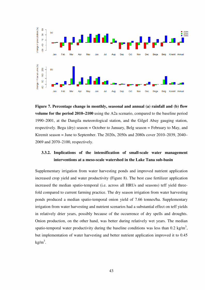
43
Figure 7. Percentage change in monthly, seasonal and annual (a) rainfall and (b) flow
volume for the period 2010–2100 using the A2a scenario, compared to the baseline period
1990–2001, at the Dangila meteorological station, and the Gilgel Abay gauging station,
respectively. Bega (dry) season = October to January, Belg season = February to May, and
Kiremit season = June to September. The 2020s, 2050s and 2080s cover 2010–2039, 2040–
2069 and 2070–2100, respectively.
3.3.2. Implications of the intensification of small-scale water management
interventions at a meso-scale watershed in the Lake Tana sub-basin
Supplementary irrigation from water harvesting ponds and improved nutrient application
increased crop yield and water productivity (Figure 8). The best case fertilizer application
increased the median spatio-temporal (i.e. across all HRUs and seasons) teff yield three-
fold compared to current farming practice. The dry season irrigation from water harvesting
ponds produced a median spatio-temporal onion yield of 7.66 tonnes/ha. Supplementary
irrigation from water harvesting and nutrient scenarios had a substantial effect on teff yields
in relatively drier years, possibly because of the occurrence of dry spells and droughts.
Onion production, on the other hand, was better during relatively wet years. The median
spatio-temporal water productivity during the baseline conditions was less than 0.2 kg/m3,
but implementation of water harvesting and better nutrient application improved it to 0.45
kg/m3.
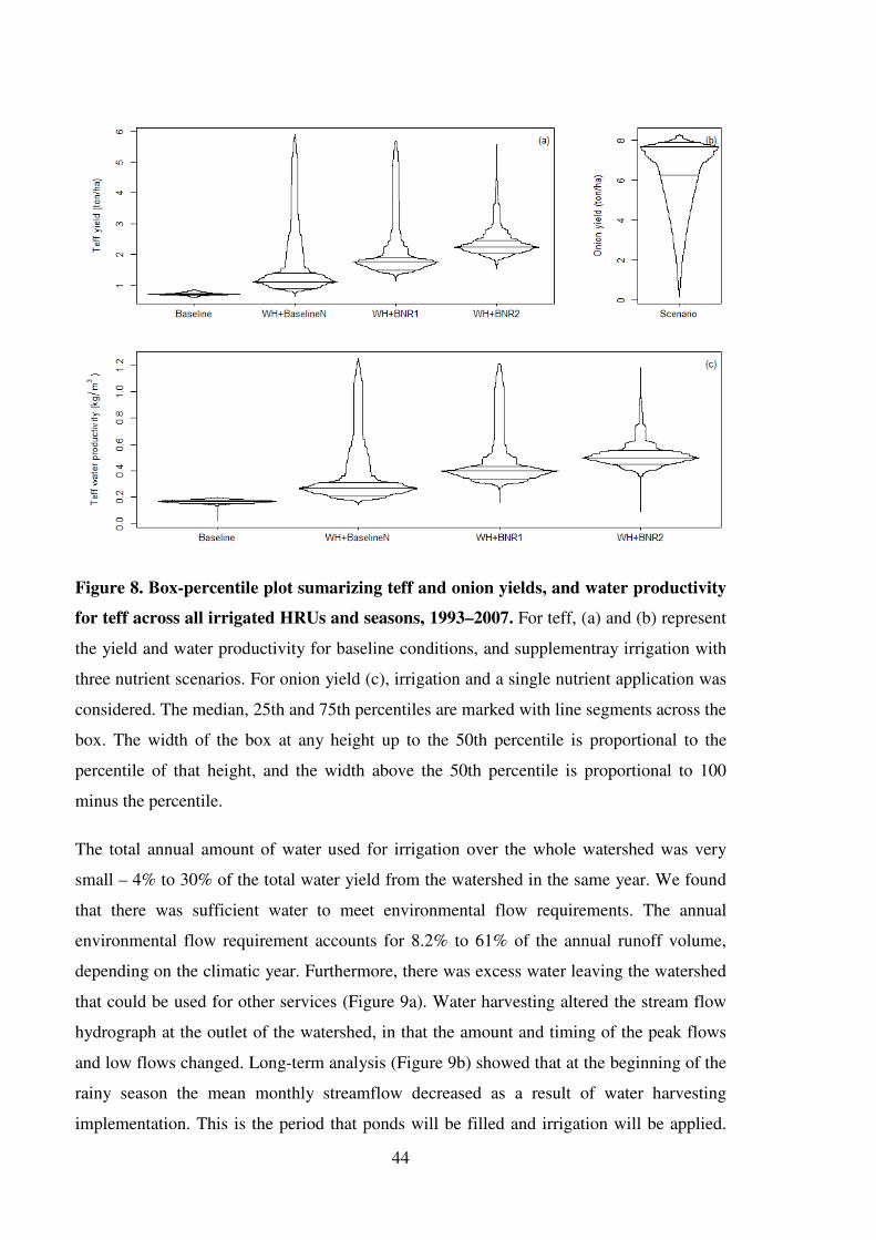
44
Figure 8. Box-percentile plot sumarizing teff and onion yields, and water productivity
for teff across all irrigated HRUs and seasons, 1993–2007. For teff, (a) and (b) represent
the yield and water productivity for baseline conditions, and supplementray irrigation with
three nutrient scenarios. For onion yield (c), irrigation and a single nutrient application was
considered. The median, 25th and 75th percentiles are marked with line segments across the
box. The width of the box at any height up to the 50th percentile is proportional to the
percentile of that height, and the width above the 50th percentile is proportional to 100
minus the percentile.
The total annual amount of water used for irrigation over the whole watershed was very
small – 4% to 30% of the total water yield from the watershed in the same year. We found
that there was sufficient water to meet environmental flow requirements. The annual
environmental flow requirement accounts for 8.2% to 61% of the annual runoff volume,
depending on the climatic year. Furthermore, there was excess water leaving the watershed
that could be used for other services (Figure 9a). Water harvesting altered the stream flow
hydrograph at the outlet of the watershed, in that the amount and timing of the peak flows
and low flows changed. Long-term analysis (Figure 9b) showed that at the beginning of the
rainy season the mean monthly streamflow decreased as a result of water harvesting
implementation. This is the period that ponds will be filled and irrigation will be applied.
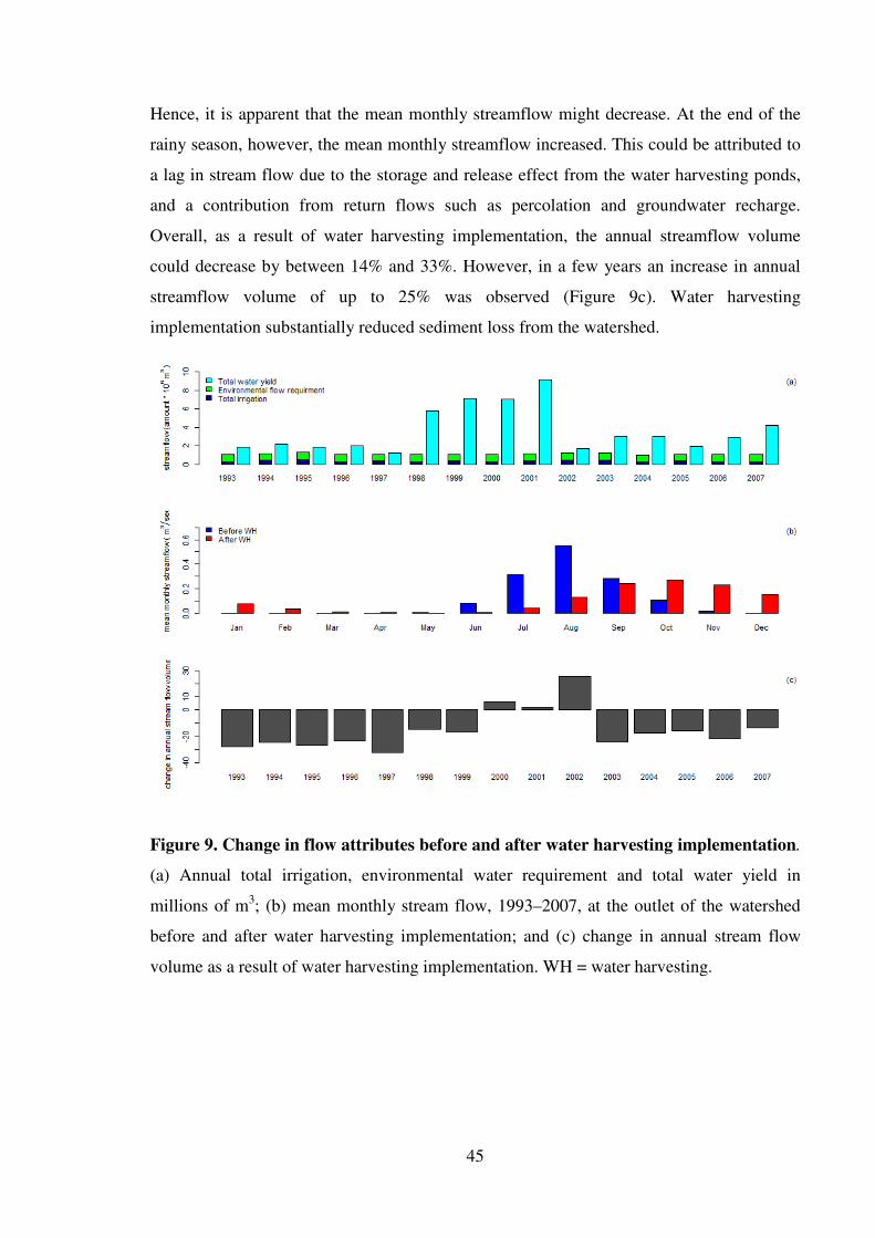
45
Hence, it is apparent that the mean monthly streamflow might decrease. At the end of the
rainy season, however, the mean monthly streamflow increased. This could be attributed to
a lag in stream flow due to the storage and release effect from the water harvesting ponds,
and a contribution from return flows such as percolation and groundwater recharge.
Overall, as a result of water harvesting implementation, the annual streamflow volume
could decrease by between 14% and 33%. However, in a few years an increase in annual
streamflow volume of up to 25% was observed (Figure 9c). Water harvesting
implementation substantially reduced sediment loss from the watershed.
Figure 9. Change in flow attributes before and after water harvesting implementation.
(a) Annual total irrigation, environmental water requirement and total water yield in
millions of m3; (b) mean monthly stream flow, 1993–2007, at the outlet of the watershed
before and after water harvesting implementation; and (c) change in annual stream flow
volume as a result of water harvesting implementation. WH = water harvesting.
46
4. DISCUSSION
4.1. Methodological approaches to understanding the implications of
water harvesting implementation
Successful water harvesting implementation entails adequate investigation of its suitability.
This thesis (Paper II, and Paper VI) places due emphasis on such analysis. In Paper II, we
took land use, soil, slope and rainfall as the main inputs for the analysis, and classified the
areas of the entire Upper Blue Nile basin into different suitability classes. This type of
analysis provides a general overview of the suitability of an area for water harvesting.
Paper VI included hydrology in the analysis so that water harvesting ponds were
implemented only where there was sufficient water for a double cropping system. These
approaches can be used to identify suitable areas for water harvesting from a biophysical
point of view. The suitability of an area for water harvesting can also be constrained by
social factors, such as access to markets, enabling environments, institutional arrangements
and so on. However, spatially explicit data on such parameters were not available for the
Upper Blue Nile basin. Where such information is available, it is possible to refine the
suitability analysis. We argue, however, that technical suitability for water harvesting is the
first step towards identifying an area for the implementation of water harvesting.
Our assessment showed that the CN method (Paper III) performed well at estimating
surface runoff, although it caused underestimates during conditions of low rainfall
intensity. When it comes to water management, however, it is the high surface runoffs that
fill ponds and reservoirs that are important. Therefore, its strength at accurately estimating
surface runoff in conditions of high rainfall intensity makes the CN method suitable for
water management applications in tropical regions.
The SWAT model is an appropriate tool for understanding the bio-physical implications of
intensifying water harvesting for upstream-downstream social-ecological systems. It has the
capacity to include different types of water harvesting intervention. The SWAT modelling
environment allowed suitable areas for the implementation of water harvesting to be
identified. For example, in this thesis (Paper VI) ex-situ water harvesting systems were
integrated into the SWAT model. It also provides key biophysical indicators that are
important for analysing the implications of intensified water harvesting systems for
upstream-downstream social-ecological systems. Moreover, the results from SWAT could
47
be integrated into other economic and ecological models in order to perform a detailed
social-ecological analysis.
4.2. Is climate change a challenge or an opportunity?
There are indications that rainfall may increase in much of East Africa (Hulme et al., 2001;
IPCC, 2007). We also showed that rainfall could increase in the Lake Tana basin. This
suggests that climate change may have positive implications for agriculture if appropriate
infrastructure is in place. Water harvesting systems will help to store the rainfall and use it
for dry season cropping for cash crop production. However, it is important to note that
climate change is also accompanied by an increase in temperature, which will increase the
evaporative demand from crops even if the fertilization effect of elevated CO2 levels from
climate change might increase crop water use efficiency (Lawlor et al., 1991). Moreover,
research has shown that climate change will increase rainfall variability, causing more
frequent dryspells and droughts (IPCC, 2012). In such cases, water harvesting systems can
store water for supplementary irrigation and thereby maintain or even increase agricultural
production. It is possible to argue that the challenges of climate change could be turned into
an opportunity through water harvesting systems in much of sub-Saharan Africa, or that
such systems could at least be used as adaptation tools to manage the challenges of climate
change.
4.3. Possible consequences of water harvesting intensification
We showed that the use of water harvesting and improved nutrient application can increase
crop production. The return from water harvesting investment varies depending on the
climatic conditions. For example, in the studied watershed, during the “dry” climatic years
water harvesting helped to bridge rainfall variability and provided better staple food
production (i.e. teff). In “wet” climatic years more onion was produced from the dry season
irrigation since sufficient water was stored in the water harvesting ponds. This suggests that
water harvesting systems can provide different functions in different climatic conditions.
We indicated that even those farmers who do not have water harvesting systems, because of
a lack of suitable areas for water harvesting or because they are located downstream of the
watershed, can receive spillover benefits that arise from a reduction in food prices and food
sharing opportunities (cf. Pretty et al., 2003). This shows the role of water harvesting in
ensuring food security both locally and regionally.

48
Water harvesting showed yield improvements with increased fertilizer application (Paper
VI). It is possible that increased nutrient application could lead to offsite nutrient leakage,
and possibly to ecological problems such as eutrophication, in the downstream riparian
ecosystems. We noted, however, that water harvesting systems can trap sediments and
embed nutrients, thereby reducing excessive nutrient loss into downstream social-
ecological systems. Moreover, in Paper I we showed that in-situ water harvesting systems
can improve soil fertility and thereby reduce the excessive nutrient requirement for crop
production. Integrating in-situ and ex-situ water harvesting systems could have a synergetic
effect in improving soil fertility and also limiting nutrient leakage.
The current understanding in regard to water harvesting implementation is either a decrease
in downstream streamflow or negligible change. We showed that both these situations were
observed in catchments with different characteristics, including climatic conditions, soil
type, land use type, topographical features and catchment size. These catchment
characteristics affect hydrological dynamics differently. Thus, implementing water
harvesting systems in such diverse catchment conditions will provide varied hydrological
responses. Furthermore, the type of water harvesting and the scale of intensification play
different roles and have different downstream consequences. This suggests that the
consequences of water harvesting on downstream streamflow might be catchment- and
context-specific. For example, the studied watershed is located in a sub-humid climatic
region, and ex-situ water harvesting was implemented on 38% of the watershed. In this
context, the results indicated that the streamflows decreased by 14%–33%, but in some
climatic years the streamflows increased by up to 25% (Paper VI).
Moreover, where implementation impact is assessed determines the extent of the
consequences. In other words, the further downstream from the implementation area, the
smaller the impact, since hydrological processes in the surrounding landscapes play an
increasing role. In addition, the magnitude and frequency of any change in runoff
generation will have to be related to the ecosystem requirements and water use needs
downstream. Thus, sensitive ecosystems may have highly specific requirements. Third, the
nature of downstream habitats, for instance habitats that are particularly valuable from an
ecological point of view, may also determine the acceptable degree of disturbance of
hydrological processes by the implementation of water harvesting.
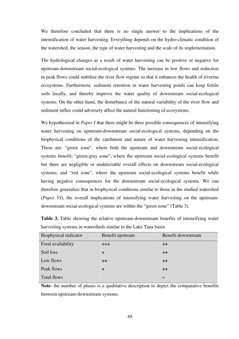
49
We therefore concluded that there is no single answer to the implications of the
intensification of water harvesting. Everything depends on the hydro-climatic condition of
the watershed, the season, the type of water harvesting and the scale of its implementation.
The hydrological changes as a result of water harvesting can be positive or negative for
upstream-downstream social-ecological systems. The increase in low flows and reduction
in peak flows could stabilize the river flow regime so that it enhances the health of riverine
ecosystems. Furthermore, sediment retention in water harvesting ponds can keep fertile
soils locally, and thereby improve the water quality of downstream social-ecological
systems. On the other hand, the disturbance of the natural variability of the river flow and
sediment influx could adversely affect the natural functioning of ecosystems.
We hypothesized in Paper I that there might be three possible consequences of intensifying
water harvesting on upstream-downstream social-ecological systems, depending on the
biophysical conditions of the catchment and nature of water harvesting intensification.
These are: “green zone”, where both the upstream and downstream social-ecological
systems benefit; “green-gray zone”, where the upstream social-ecological systems benefit
but there are negligible or undetectable overall effects on downstream social-ecological
systems; and “red zone”, where the upstream social-ecological systems benefit while
having negative consequences for the downstream social-ecological systems. We can
therefore generalize that in biophysical conditions similar to those in the studied watershed
(Paper VI), the overall implications of intensifying water harvesting on the upstream-
downstream social-ecological systems are within the “green zone” (Table 3).
Table 3. Table showing the relative upstream-downstream benefits of intensifying water
harvesting systems in watersheds similar to the Lake Tana basin
Biophysical indicator Benefit upstream Benefit downstream
Food availability +++ ++
Soil loss + ++
Low flows ++ ++
Peak flows + ++
Total flows –
Note: the number of pluses is a qualitative description to depict the comparative benefits
between upstream-downstream systems.
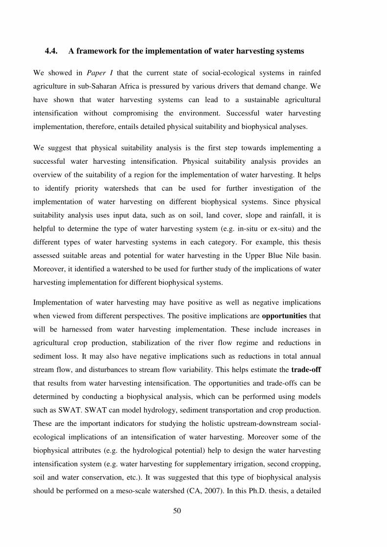
50
4.4. A framework for the implementation of water harvesting systems
We showed in Paper I that the current state of social-ecological systems in rainfed
agriculture in sub-Saharan Africa is pressured by various drivers that demand change. We
have shown that water harvesting systems can lead to a sustainable agricultural
intensification without compromising the environment. Successful water harvesting
implementation, therefore, entails detailed physical suitability and biophysical analyses.
We suggest that physical suitability analysis is the first step towards implementing a
successful water harvesting intensification. Physical suitability analysis provides an
overview of the suitability of a region for the implementation of water harvesting. It helps
to identify priority watersheds that can be used for further investigation of the
implementation of water harvesting on different biophysical systems. Since physical
suitability analysis uses input data, such as on soil, land cover, slope and rainfall, it is
helpful to determine the type of water harvesting system (e.g. in-situ or ex-situ) and the
different types of water harvesting systems in each category. For example, this thesis
assessed suitable areas and potential for water harvesting in the Upper Blue Nile basin.
Moreover, it identified a watershed to be used for further study of the implications of water
harvesting implementation for different biophysical systems.
Implementation of water harvesting may have positive as well as negative implications
when viewed from different perspectives. The positive implications are opportunities that
will be harnessed from water harvesting implementation. These include increases in
agricultural crop production, stabilization of the river flow regime and reductions in
sediment loss. It may also have negative implications such as reductions in total annual
stream flow, and disturbances to stream flow variability. This helps estimate the trade-off
that results from water harvesting intensification. The opportunities and trade-offs can be
determined by conducting a biophysical analysis, which can be performed using models
such as SWAT. SWAT can model hydrology, sediment transportation and crop production.
These are the important indicators for studying the holistic upstream-downstream social-
ecological implications of an intensification of water harvesting. Moreover some of the
biophysical attributes (e.g. the hydrological potential) help to design the water harvesting
intensification system (e.g. water harvesting for supplementary irrigation, second cropping,
soil and water conservation, etc.). It was suggested that this type of biophysical analysis
should be performed on a meso-scale watershed (CA, 2007). In this Ph.D. thesis, a detailed
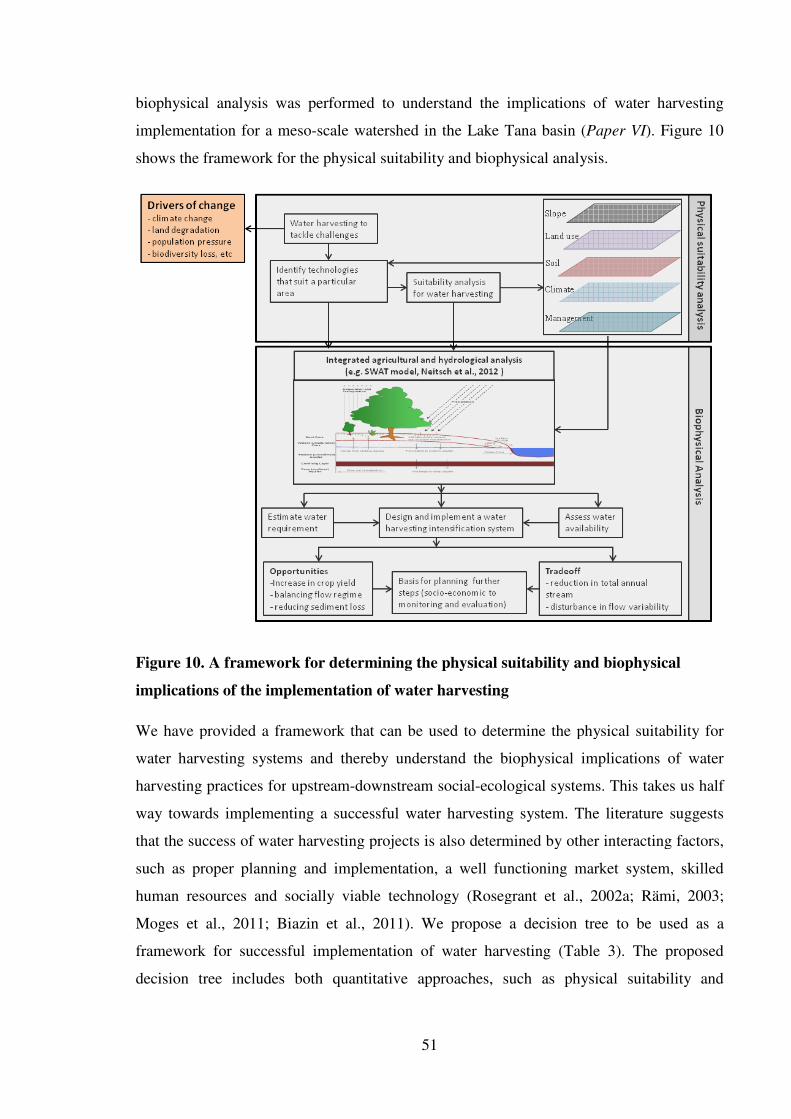
biophysical analysis was performed to understand the implications of water harvesting
implementation for a meso
shows the framework for the physical suitability and biophysical analysis.
Figure 10. A framework for determining
implications of the implementation
We have provided a framework that can be used to determine the physical suitability for
water harvesting systems and thereby understand the biophysical implications of water
harvesting practices for
way towards implementing a successful water harvesting system.
that the success of water harvesting projects is also determined by other interacting factors
such as proper planning and implementation,
human resources and socially viable technology
Moges et al., 2011; Biazin et al., 2011)
framework for successful implementation
decision tree includes both quantitative approaches
51
biophysical analysis was performed to understand the implications of water harvesting
a meso-scale watershed in the Lake Tana basin (
s the framework for the physical suitability and biophysical analysis.
A framework for determining the physical suitability and biophysical
implementation of water harvesting
provided a framework that can be used to determine the physical suitability for
water harvesting systems and thereby understand the biophysical implications of water
for upstream-downstream social-ecological systems. This
way towards implementing a successful water harvesting system.
that the success of water harvesting projects is also determined by other interacting factors
such as proper planning and implementation, a well functioning market
and socially viable technology (Rosegrant et al., 2002a; Rämi, 2003;
Moges et al., 2011; Biazin et al., 2011). We propose a decision tree
sful implementation of water harvesting (Table 3). The proposed
decision tree includes both quantitative approaches, such as physical suitability and
biophysical analysis was performed to understand the implications of water harvesting
scale watershed in the Lake Tana basin (Paper VI). Figure 10
s the framework for the physical suitability and biophysical analysis.
physical suitability and biophysical
provided a framework that can be used to determine the physical suitability for
water harvesting systems and thereby understand the biophysical implications of water
ecological systems. This takes us half
way towards implementing a successful water harvesting system. The literature suggests
that the success of water harvesting projects is also determined by other interacting factors,
well functioning market system, skilled
(Rosegrant et al., 2002a; Rämi, 2003;
. We propose a decision tree to be used as a
(Table 3). The proposed
such as physical suitability and
52
biophysical analysis (discussed above), and qualitative approaches, ranging from socio-
economic analysis to monitoring and evaluation.
Socio-economic analysis such as cost-benefit analysis and comparative economic studies
among different technologies should be conducted to get a better insight into selecting the
most profitable technology. The economic analysis should consider both short-term and
long-term benefits. Some technologies, such as in-situ water harvesting systems, have long-
term benefits and their short-term benefits may not be easily visible. Access to markets,
labour availability, resource endowment, such as wealth including land, and gender and
education are among the key determinants of water harvesting implementation that require
thorough consideration in the socio-economic analysis (e.g. Munamati and Nyagumbo,
2010). For example Biazin et al. (2011) suggest that the production of vegetables using
water harvesting requires a market that is easily accessible, since the produce cannot be
stored or transported easily. Boyd et al. (2000) show how improved access to markets and
increased producer prices stimulate investment in in-situ water harvesting systems at the
household level in Tanzania. Rämi (2003) reports that ex-situ water harvesting systems are
labour-intensive. Munamati and Nyagumbo (2010) show that resource status and gender
issues were directly related to the performance of in-situ water harvesting in the Gwanda
district of Zimbabwe: wealthy and man-headed households performed better with in-situ
water harvesting systems. Boyd et al. (2000) showed that farmers with some level of
education performed better with in-situ water harvesting systems than with those with no
education. Social values and settings also determine the uptake of water harvesting systems.
For example, the konso people in southern Ethiopia are known for constructing terracing
systems. They can easily understand and implement different types of in-situ water
harvesting system. Some societies may be reluctant to use ex-situ water harvesting systems,
believing that such systems might increase the incidence of malaria, as well as the risk of
drowning for children and animals (Rami, 2003). Thus, socio-economic analysis aids the
design of water harvesting systems that fit the socio-economic context of a given area.
Stakeholder consultation and an accompanying site visit can help to cross-check the
feasibility of identified water harvesting systems in the local context. Moreover,
consultations with beneficiaries, government agencies and non-governmental organizations
help to identify specific challenges and opportunities that should be included in the design
and planning of water harvesting implementation. For example, Rämi (2003) reports that
some farmers prefer water harvesting systems that require less human input in their
53
construction and use. In regions where there is land scarcity, farmers are more interested in
water harvesting systems that take up less space. This dialogue with the stakeholders can be
used to create awareness of and thus develop interest in implementing the technologies. It
also creates avenues for capacity building on how to implement, use and maintain the
technologies. Engaging the stakeholders, particularly farmers, creates ownership of the
projects, which increases the sense of responsibility for maintaining and taking care of the
systems. This, in turn, increases the chances of success.
Planning and implementation in this thesis refers to putting the project into practice based
on the collected evidence discussed above. It includes mobilizing funds to initiate projects.
It is argued that the initial investment required for water harvesting systems is too
expensive (Rämi, 2003) and that farmers may not have the start-up finance for such
investments. In such cases, arranging micro-credit opportunities could be one option for
financial sources. Moreover, the planning of linkages between beneficiaries and profitable
markets can provide higher returns on the investment. Economic incentives could therefore
promote the adoption of water harvesting systems (e.g. Hatibu et al., 2006). The other
determining factor for the success of water harvesting implementation is establishing clear
institutional settings, responsibilities and coordination among different levels of
government hierarchies. For example, in Ethiopia the lack of coordination between the
Ministry of Agriculture and Rural Development, which was the initiator of the national
water harvesting projects, and the regional authorities, which were responsible for the
planning and implementation, was high among the causes of failure of water harvesting
implementation in the country (Awulachew et al., 2005; Moges et al., 2011). Capacity
building at all levels of society builds skilled manpower that can execute projects
successfully. Needless to say, employing appropriate construction practices and timely
delivery of construction materials are important steps in implementing functioning physical
infrastructure. Rämi (2003) reported that lack of construction materials such as cement and
wire-mesh for plastered tanks, and of polyethylene membrane for ponds had costly
consequences for the success of the 2002–2003 water harvesting implementation in the
Amhara region of Ethiopia.
Governments or NGOs are often keen to build water harvesting systems but do not follow
up on the development of the intervention. Monitoring and evaluation is one of the key
steps to achieving successful implementation of water harvesting. Proper operation and
maintenance of the technology determines the productivity and functioning of water
54
harvesting systems. This in turn depends on the availability of spare parts in local markets,
and trained personnel who can repair malfunctioning systems (Rämi, 2003; Awulachew et
al., 2005). Moreover, the system should be progressively evaluated and adapted to changing
situations or modified to take account of factors not foreseen during the inception of the
project. The system should also be upgraded to include emerging and modern technologies.
Besides mainstream water harvesting practices, experimentation with traditionally available
water harvesting systems could result in low cost and efficient systems that are tailored to
local contexts. For example, Rämi (2003) reported that farmers in Tigray, Ethiopia invented
an ingenious drip irrigation system that minimizes water loss.
We have shown that water harvesting systems can help to build sustainable agricultural
intensification as well as resilience against climatic shocks. Governments, NGOs and
research institutions have backed them despite their various ups and downs. There are
hopes that Africa is rising (Economist, 2011). Will water harvesting be used throughout the
development process and afterwards, only during the transition phase or not at all? One
must hope to live long enough to see how this unfolds.
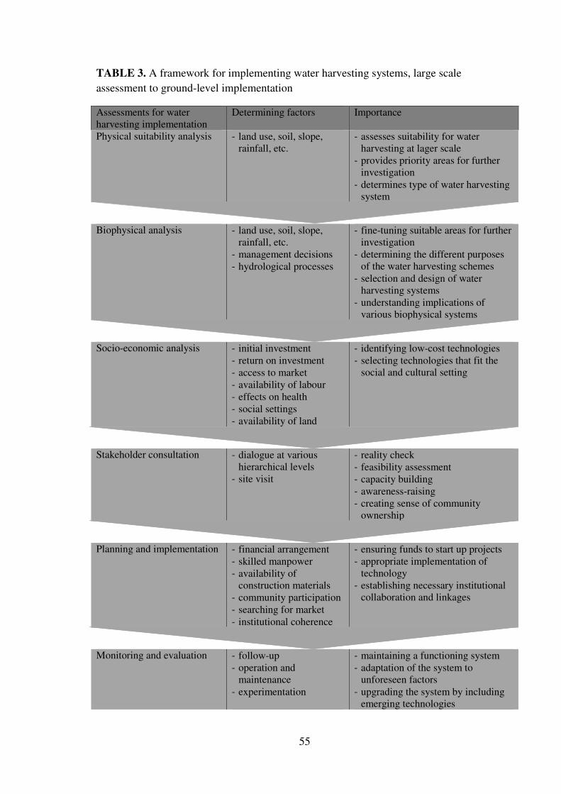
55
TABLE 3. A framework for implementing water harvesting systems, large scale
assessment to ground-level implementation
Assessments for water harvesting implementation
Determining factors Importance
Physical suitability analysis - land use, soil, slope, rainfall, etc.
- assesses suitability for water harvesting at lager scale
- provides priority areas for further investigation
- determines type of water harvesting system
Biophysical analysis - land use, soil, slope, rainfall, etc.
- management decisions - hydrological processes
- fine-tuning suitable areas for further investigation
- determining the different purposes of the water harvesting schemes
- selection and design of water harvesting systems
- understanding implications of various biophysical systems
Socio-economic analysis - initial investment
- return on investment - access to market - availability of labour - effects on health - social settings - availability of land
- identifying low-cost technologies - selecting technologies that fit the
social and cultural setting
Stakeholder consultation - dialogue at various hierarchical levels
- site visit
- reality check - feasibility assessment - capacity building - awareness-raising - creating sense of community
ownership
Planning and implementation - financial arrangement
- skilled manpower - availability of
construction materials - community participation - searching for market - institutional coherence
- ensuring funds to start up projects - appropriate implementation of
technology - establishing necessary institutional
collaboration and linkages
Monitoring and evaluation - follow-up - operation and
maintenance - experimentation
- maintaining a functioning system - adaptation of the system to
unforeseen factors - upgrading the system by including
emerging technologies
56
5. CONCLUDING REMARKS
� The Curve Number method estimates surface runoff at high rainfall intensity pretty
well. This indicates that it is a useful method for water management applications in
tropical regions, since the runoff from high rainfall intensity counts for filling
reservoirs and ponds.
� Data scarcity is one of the challenges for hydrological modelling and water
management purposes. The CFSR weather data proved to be a good substitute for
conventional weather data in climate data-scarce environments.
� Taking the Upper Blue Nile basin (Paper II) and the meso-scale watershed in the
Lake Tana basin (Paper VI) as typical examples, we found that there is huge
potential for implementation of water harvesting in sub-Saharan Africa.
Water harvesting has the potential to improve staple food production, and to
produce cash crops that help to achieve food security. Moreover, it has the potential
to build sustainable agricultural intensification practices, as well as resilience
against water-related shocks.
� Water harvesting upstream does not automatically mean a reduction in annual
streamflow downstream. The implications depend on dynamic and non-linear
hydrological processes and complex interacting factors. There can, therefore, be
multiple hydrological implications.
� Water harvesting ponds buffer river flow variability, and modify the river flow
regime and sediment transportation. These can have positive consequences in
providing sustained streamflow throughout the year and improving water quality. At
the same time, these changes may have negative consequences – particularly for
riverine ecosystems.
� The increase in annual rainfall in East Africa as a result of climate change could
become an opportunity to mitigate the unprecedented challenges of climate change
through the use of water harvesting systems. Water harvesting systems can store
water for supplementary irrigation in order to bridge rainfall variability and provide
more water for dry season cropping of cash crops.
� Establishing a successful water harvesting system requires a chain of processes
from detailed technical analysis to progressive monitoring and evaluation.
57
REFERENCES
Abbaspour, K.C., Johnson, C. a., van Genuchten, M.T., 2004. Estimating Uncertain Flow
and Transport Parameters Using a Sequential Uncertainty Fitting Procedure. Vadose
Zo. J. 3, 1340–1352.
Abbaspour, K.C., Yang, J., Maximov, I., Siber, R., Bogner, K., Mieleitner, J., Zobrist, J.,
Srinivasan, R., 2007. Modelling hydrology and water quality in the pre-alpine/alpine
Thur watershed using SWAT. J. Hydrol. 333, 413–430.
Andersson, J.C.M., Zehnder, A.J.B., Rockström, J., Yang, H., 2011. Potential impacts of
water harvesting and ecological sanitation on crop yield , evaporation and river flow
regimes in the Thukela River basin , South Africa. Agric. Water Manag. Elsevier B.V.
98, 1113–1124.
Arnell, N., 2009. Beyond 4 oC: impacts across the global scale. Clim. Conf., 4 Degrees
Beyond Implic. a Glob. Clim. Chang. 4+ degrees people, Ecosyst. earth Syst. Oxford,
28–30 Sept. 2009. Environmental Change Institute., Oxford, UK.
Awulachew, S.B., Merrey, D.J., Kamara, A.B., Koppen, V.B., Vries, F.P. de, Boelee, E.,
Makombe, G., 2005. Experiences and opportunities for promoting small-scale/micro
irrigation and rainwater harvesting for food security in Ethiopia. Colombo, Sri Lanka:
IWMI. (Working paper 98). Addis Ababa, Ethiopia, p. 86.
Barron, J., Okwach, G., 2005. Run-off water harvesting for dry spell mitigation in maize (
Zea mays L .): results from on-farm research in semi-arid Kenya. Agric. Water Manag.
74, 1–21.
Barron, J., Rockstrom, J., Gichuki, F., Hatibu, N., 2003. Dry spell analysis and maize yields
for two semi-arid locations in east Africa. Agric. For. Meteorol. 117, 23–37.
Batchelor, C.H., Rao, M.S.R.M., Manohar, S., 2003. Watershed development : A solution
to water shortages in semi-arid India or part of the problem? L. Use Water Resour.
Res. 3, 1–10.
BCEOM, 1998. ABBAY RIVER BASIN INTEGRATED DEVELOPMENT MASTER
PLAN PROJECT. Addis Ababa, Ethiopia, p. 140.
Betrie, G.D., Mohamed, Y. a., van Griensven, A., Srinivasan, R., 2011. Sediment
management modelling in the Blue Nile Basin using SWAT model. Hydrol. Earth
Syst. Sci. 15, 807–818.
58
Biazin, B., Sterk, G., Temesgen, M., Abdulkedir, A., Stroosnijder, L., 2011. Rainwater
harvesting and management in rainfed agricultural systems in sub-Saharan Africa – A
review. Phys. Chem. Earth, Parts A/B/C. Elsevier Ltd.
Biazin, B., Sterk, G., Temesgen, M., Abdulkedir, A., Stroosnijder, L., 2012. Rainwater
harvesting and management in rainfed agricultural systems in sub-Saharan Africa – A
review. Phys. Chem. Earth, Parts A/B/C. Elsevier Ltd. 47-48, 139–151.
Borah, D.K., Bera, M., 2003. Watershed-Scale Hydrologic And Nonpoint-Source Pollution
Models: Review Of Mathematical Bases. Trans. ASAE. 46, 1553–1566.
Boyd, C., Turton, C., Hatibu, N., Mahoo, H.F., Lazaro, E., Rwehumbiza, F.B., Okubal, P.,
Makumb, M., 2000. The Contribution of Soil and Water Conservation to Sustainable
Livelihoods in Semi-Arid Areas of Sub-Saharan Africa. Agricultural Research &
Extension Network, Network Paper No 102, p. 20.
CA, 2007. Water for food Water for life: A Comprehensive Assessment of Water
Management in Agriculture. Molden, D. (Ed.). International Water Management
Institute, Colombo, p. 644.
Canada, E., 2009. HadCM3 Predictors: A2(a) and B2(a) Experiments.
CGIAR-CSI, 2009. SRTM 90m Digital Elevation Data.
Chen, S., Ravallion, M., 2007. Absolute Poverty Measures for the Developing World,
1981-2004, p. 24.
Christensen, J., Hewitson, B., Busuioc, A., Chen, A., Gao, X., Held, R., Jones, R., Kolli, R.,
Kwon, W., Laprise, R., Magana Rueda, V., Mearns, L., Menendez, C., Räisänen, J.,
Rinke, A., Sarr, A., Whetton, P., Arritt, R., Benestad, R., Beniston, M., Bromwich, D.,
Caya, D., Comiso, J., de Elia, R., Dethloff, K., 2007. Regional climate projections ,
Climate Change, 2007: The Physical Science Basis. Contribution of Working group I
to the Fourth Assessment Report of the Intergovernmental Panel on Climate Change.
Cambridge University Press, United Kingdom, New York, NY, USA.
Collick, A.S., Easton, Z.M., Ashagrie, T., Biruk, B., Tilahun, S., Adgo, E., Awulachew,
S.B., Zeleke, G., Steenhuis, T.S., 2009. A simple semi-distributed water balance
model for the Ethiopian highlands. Hydrol. Process. 23, 3718–3727.
Critchley, W., Siegert, K., 1991. Water Harvesting; A Manual for the Design and
Construction of Water Harvesting Schemes for Plant Production.
CSA, 2012. Central Statistical Authority of Ethiopia http://www.csa.gov.et/.
59
De Winnaar, G., Jewitt, G., 2010. Ecohydrological implications of runoff harvesting in the
headwaters of the Thukela River basin, South Africa. Phys. Chem. Earth, Parts A/B/C.
Elsevier Ltd. 35, 634–642.
DFID, 2004. Agriculture, growth and poverty reduction. Oxford, p. 26.
Dile, Y.T., Berndtsson, R., Setegn, S.G., 2013a. Hydrological Response to Climate Change
for Gilgel Abay River, in the Lake Tana Basin - Upper Blue Nile Basin of Ethiopia.
Añel, J.A. (Ed.), PLoS One. 8, e79296.
Dile, Y.T., Karlberg, L., Temesgen, M., Rockstrom, J., 2013b. The role of water harvesting
to achieve sustainable agricultural intensification and resilience against water related
shocks in sub-Saharan Africa. Agric. Ecosyst. Environ. Elsevier B.V. 181, 69–79.
Easton, Z.M., Fuka, D., White, E., Collick, A.S., Ashagre, B.B., McCartney, M.,
Awulachew, S., 2010. A multi basin SWAT model analysis of runoff and
sedimentation in the Blue Nile, Ethiopia. Hydrol. Earth Syst. Sci. 14, 1827–1841.
Economist, 2011. The hopeful continenet: Africa rising, Dec 3rd 2011. Econ.
EIAR, 2007. Crop technologies usage (in Amharic). Addis Ababa, Ethiopia, p. 174.
El-Nasr, A.A., Arnold, J.G., Feyen, J., Berlamont, J., 2005. Modelling the hydrology of a
catchment using a distributed and a semi-distributed model. Hydrol. Process. 19, 573–
587.
Enfors, E., Gordon, L., 2008. Dealing with drought: The challenge of using water system
technologies to break dryland poverty traps. Glob. Environ. Chang. 18, 607–616.
Enfors, E.I., Gordon, L.J., 2007. Analysing resilience in dryland agro-ecosystems: a case
study of the Makaya catchment in Tanzania over the past 50 years. L. Degrad. Dev.
18, 680–696.
ENMSA, 2012. Metreological data: The Ethiopian National Metreological Services
Agency. Addis Ababa, Ethiopia. Ethiopian National Meteorological Services Agency,
Bahir Dar, Ethiopia.
Falkenmark, M., Rockström, J., 2008. Building resilience to drought in desertification-
prone savannas in Sub-Saharan Africa: The water perspective. Nat. Resour. Forum.
32, 93–102.
FAO, 1995. World Soil Resources: An explanatory note on the FAO (Food and Agriculture
Organization) World Soil Resources Map at 1:25 000 00 scale. Rome, Italy.
FAO, 2002. World Agriculture: Towards 2015/2030: Summary Report. Food and
Agriculture Organization of the United Nations, Rome.
60
FAO, 2006. World reference base for soil resources 2006: A framework for international
classification, correlation and communication. Rome.
FAO, 2010. The State of Food Insecurity in the World Addressing food insecurity in
protracted crises. Notes. Food and Agriculture Organization of the United Nations,
Rome, p. 62.
FAO, 2011. The State of the World’s Land and Water Resources for Food and Agriculture.
Organization. Food and Agriculture Organization of the United Nations, Rome.
Fatondji, D., Martius, C., Bielders, C.L., Vlek, P.L.G., Bationo, a., Gerard, B., 2006. Effect
of planting technique and amendment type on pearl millet yield, nutrient uptake, and
water use on degraded land in Niger. Nutr. Cycl. Agroecosystems. 76, 203–217.
Foley, J., Ramankutty, N., Brauman, K.A., Cassidy, E.S., Gerber, J.S., Johnston, M.,
Mueller, N.D., O’Connell, C., Ray, D.K., West, P.C., Balzer, C., Bennett, E.M.,
Carpenter, S.R., Hill, J., Monfreda, C., Polasky, S., Rockström, J., Sheehan, J., Siebert,
S., Tilman, D., Zaks, D.P.M., 2011. Solutions for a cultivated planet. Nature. 000, 1–6.
Folke, C., 2003. Freshwater for resilience: a shift in Thinking. Phil. Trans. R. Soc. London.
358, 2027–2036.
Folke, C., Carpenter, S., Walker, B., Scheffer, M., Elmqvist, T., Gunderson, L., Holling,
C.S., 2004. Regime Shifts, Resilience, and Biodiversity in Ecosystem Management.
Annu. Rev. Ecol. Evol. Syst. 35, 557–581.
Folke, C., Carpenter, S.R., Walker, B., Scheffer, M., Chapin, T., Rockström, J., 2010.
Resilience Thinking : Integrating Resilience , Adaptability and Transformability. Ecol.
socity. 15, 20.
Fox, P., Rockstrom, J., 2003. Supplemental irrigation for dry-spell mitigation of rainfed
agriculture in the Sahel. Agric. Water Manag. 61, 29–50.
Gallup, J.L., Radelet, S., Warne, A., 1998. Economic growth and the income of the poor.
Cambridge, MA, USA.
Garg, K.K., Wani, S.P., Barron, J., Karlberg, L., Rockstrom, J., 2012. Upscaling potential
impacts of water flows from agricultural water interventions: opportunities and trade-
offs in the Osman Sagar catchment, Musi sub basin, India. Hydrol. Process.
Gebreegziabher, T., Nyssen, J., Govaerts, B., Getnet, F., Behailu, M., Haile, M., Deckers,
J., 2009. Contour furrows for in situ soil and water conservation, Tigray, Northern
Ethiopia. Soil Tillage Res. 103, 257–264.
61
Gebremichael, D., Nyssen, J., Poesen, J., Deckers, J., Haile, M., Govers, G., Moeyersons,
J., 2005. Effectiveness of stone bunds in controlling soil erosion on cropland in the
Tigray Highlands, northern Ethiopia. Soil Use Manag. 21, 287–297.
Glendenning, C.J., Vervoort, R.W., 2011. Hydrological impacts of rainwater harvesting
(RWH) in a case study catchment: The Arvari River, Rajasthan, IndiaPart 2.
Catchment-scale impacts. Agric. Water Manag. Elsevier B.V. 98, 715–730.
Globalweather, 2012. NCEP Climate Forecast System Reanalysis (CFRS).
GWSA, 2012. Angereb Reservior Data: Gondor town municipality Water Supply
Authority. Gondor, Ethiopia. Gondor Town Manuscipality Water Supply Authority
(GWSA), Gondor.
Hatibu, N., Mutabazi, K., Senkondo, E., Msangi, a, 2006. Economics of rainwater
harvesting for crop enterprises in semi-arid areas of East Africa. Agric. Water Manag.
80, 74–86.
Herweg, K., Ludi, E., 1999. The performance of selected soil and water conservation
measures—case studies from Ethiopia and Eritrea. Catena. 99–114.
Holling, C.S., 1973. Resilience And Stability Of Ecological Systems. Annu. Rev.
ofEcology Syst. 4, 1–23.
Hulme, M., Doherty, R., Ngara, T., New, M., Lister, D., 2001. African climate change :
1900 – 2100. Clim. Res. 17, 145–168.
IAASTD, 2009. International Assessment of Agricultural Knowledge, Science and
Technology for Development: Summary for Decision Makers of the Sub-Saharan
Africa Report. Assessment. International Assessment of Agricultural Knowledge,
Science and Technology for Development, Johannesburg, p. 24.
IFAD, 2009. Federal Democratic Republic of Ethiopia: Country Program Evaluation, p.
127.
IFAD, 2011. Rural Poverty Report: New Realities New Challenges: New Opportunities for
tomorrow’s generation. Rome, p. 332.
IPCC, 2007. Climate Change 2007: The physical Science Basis. Contribution of Working
Group I to the Fourth Assessment Report of the Intergovernmental Panel on Climate
Change. Solomon, S.D.Q., Manning, M., Chen, Z., Marquis, M., Averyt, K.B., Tignor,
M. (Eds.). Cambridge University Press, Cambridge, United Kingdom and New York,
NY, USA.
IPCC, 2012. Summary for Policymakers. In: Managing the Risks of Extreme Events and
Disasters to Advance Climate Change Adaptation [Field, C.B., V. Barros, T.F.
62
Stocker, D. Qin, D.J. Dokken, K.L. Ebi, M.D. Mastrandrea, K.J. Mach, G.-K. Plattner,
S.K. Allen, M. Tignor,. Cambridge University Press, Cambridge, UK, and New York,
pp. 1–19.
Jensen, J.R., Bernhard, R.H., Hansen, S., Mcdonagh, J., Mùberg, J.P., Nielsen, N.E.,
Nordbo, E., 2003. Productivity in maize based cropping systems under various soil-
water-nutrient management strategies in a semi-arid , alfisol environment in East
Africa. Agric. Water Manag. 59, 217–237.
Kahinda, M., Lillie, E.S.B., Taigbenu, A.E., Taute, M., Boroto, R.J., 2008. Developing
suitability maps for rainwater harvesting in South Africa. Phys. Chem. Earth. 33, 788–
799.
Kim, U., Kaluarachchi, J.J., 2009. Climate Change Impacts on Water Resources in the
Upper Blue Nile River Basin, Ethiopia. J. Am. Water Resour. Assoc. 45, 1361–1378.
Lal, R., 2001. Potential of desertification control to sequester carbon and mitigate the
greenhouse effect. Clim. Change. 51, 35–72.
Lawlor, D.W., Afrc, R.A.C.M., Crops, A., 1991. The effects of increasing CO2 on crop
photosynthesis and productivity : a review of field studies. Plant, Cell Environ. 14,
807–818.
Liniger, H., Studer, R.M., Hauert, C., Gurtner, M., 2011. Sustainable Land Management in
Practice: Guidlines and Best Management Practices for Sub-Saharan Africa.
Management. FAO, Rome.
Liu, B.M., Collick, A.S., Zeleke, G., Adgo, E., Easton, Z.M., Steenhuis, T.S., 2008.
Rainfall-discharge relationships for a monsoonal climate in the Ethiopian highlands.
Hydrol. Process. 22, 1059–1067.
Mati, B., Tanguy, D.B., Maimbo, M., Khaka, E., Alex, O., Meshack, N., Vincent, O., 2006.
Mapping the Potential of Rainwater Harvesting Technologies in Africa:A GIS
overview on development domains for the continent and ten selected countries. World
Agroforestry Centre (ICRAF), Netherlands Ministry of Foreign Affairs, Nairobi,
Kenya, p. 116.
Mbilinyi, B.P., Tumbo, S.D., Mahoo, H.F., Mkiramwinyi, F.O., 2007. GIS-based decision
support system for identifying potential sites for rainwater harvesting. Phys. Chem.
Earth. 32, 1074–1081.
McHugh, O. V., Steenhuis, T.S., Fernandes, E.C.M., 2007. Performance of in situ rainwater
conservation tillage techniques on dry spell mitigation and erosion control in the
63
drought-prone North Wello zone of the Ethiopian highlands. Soil Tillage Res. 97, 19–
36.
Mearns, L., Giorgi, F., Whetton, P., Pabon, D., Hulme, M., Lal, M., 2003. Guidelines for
use of climate scenarios developed from Regional Climate Model experiments., p. 38.
Moges, G., Hengsdijk, H., Jansen, H.C., 2011. Review and quantitative assessment of ex
situ household rainwater harvesting systems in Ethiopia. Agric. Water Manag.
Elsevier B.V. 98, 1215–1227.
Molden, D., Oweis, T., Steduto, P., Bindraban, P., Hanjra, M. a., Kijne, J., 2010. Improving
agricultural water productivity: Between optimism and caution. Agric. Water Manag.
97, 528–535.
Moriasi, D.N., Arnold, J.G., Liew, M.W. Van, Bingner, R.L., Harmel, R.D., Veith, T.L.,
2007. Model Evaluation Guidlines for Systematic Quantification of Accuracy in
Watershed Simulations. Trans. ASABE. 50, 885–900.
MoWE, 2012. Hydrological data: The Ethiopian Ministry of Water and Energy (MoWE).
Addis Ababa, Ethiopia. Addis Ababa, Ethiopia.
MoWR, 1998. Abay river basin integrated development master plan project. Addis Ababa,
Ethiopia. Addis Ababa, p. 140.
MoWR, 2009. Land use and soil data: Ethiopian Minstry of Water Resources. Addis
Ababa, Ethiopia.
Munamati, M., Nyagumbo, I., 2010. In situ rainwater harvesting using dead level contours
in semi-arid southern Zimbabwe: Insights on the role of socio-economic factors on
performance and effectiveness in Gwanda District. Phys. Chem. Earth, Parts A/B/C.
Elsevier Ltd. 35, 699–705.
Neitsch, S.L., Arnold, J.G., Kiniry, J.R., Williams, J.. R., 2012. Soil and Water Assessment
Tool Theoretical Documentation: Version 2005. Grassland Soil and Water Research
Laboratory, Agricultural Research Service, Blackland Research Center, Texas
Agricultural Experiment Station, Temple, Texas, p. 494.
Neumann, K., Verbur, P., Stehfest, E., Müller, C., 2010. A global analysis of the
intensification potential for grain production. Agric. Syst. 103, 316–326.
Ngigi, S.N., Savenije, H.H.G., Thome, J.N., Rockstro, J., Vriesd, F.W.T.P. de, 2005. Agro-
hydrological evaluation of on-farm rainwater storage systems for supplemental
irrigation in Laikipia district , Kenya. Agric. Water Manag. 73, 21–41.
64
Norfolk, O., Abdel-Dayem, M., Gilbert, F., 2012. Rainwater harvesting and arthropod
biodiversity within an arid agro-ecosystem. Agric. Ecosyst. Environ. Elsevier B.V.
162, 8–14.
Oweis, T., Hachum, A., 2006. Water harvesting and supplemental irrigation for improved
water productivity of dry farming systems in West Asia and North Africa. Agric.
Water Manag. 80, 57–73.
Pandey, D.N., 2001. A Bountiful Harvest of Rainwater. Science (80-. ). 293, 1763.
Parajuli, P.B., Nelson, N.O., Frees, L.D., Mankin, K.R., 2009. Comparison of AnnAGNPS
and SWAT model simulation results in USDA-CEAP agricultural watersheds in south-
central Kansas. Hydrol. Process. 763, 748–763.
Ponce, B.V.M., Hawkins, R.H., 1996. Runoff Curve Number - has it reached maturity? J.
Hydrol. Eng. 1, 11–19.
Pretty, J.., Morison, J.I.., Hine, R.., 2003. Reducing food poverty by increasing agricultural
sustainability in developing countries. Agric. Ecosyst. Environ. 95, 217–234.
Pretty, J.N., Nobel, A.D., Bossio, D., Dixon, J., Hine, R.E., Penning, F.W.T., Veries, P. De,
Morison, J.I.L., 2006. Resource-Conserving Agriculture Increases Yields in
Developing Countries. Environ. Sci. Technol. 40.
Rämi, H., 2003. Ponds filled with challenges. Ethiopia, p. 26.
Reij, C., Tappan, G., Smale, M., 2009. Agroenvironmental Transformation in the Sahel:
Another Kind of “Green Revolution” IFPRI Discussion Paper 00914. Food Policy.
Washington DC, USA, p. 52.
ResilienceAlliance, 2010. Assessing resilience in social-ecological systems: Workbook for
practitioners. Version 2.0., p. 54.
Rockstrom, J., Barron, J., Fox, P., 2002. Rainwater management for increased productivity
among small-holder farmers in drought prone environments. Phys. Chem. Earth. 27,
949–959.
Rockström, J., Falkenmark, M., 2000. Semiarid Crop Production from a Hydrological
Perspective - Gap between Potential and Actual Yields. CRC. Crit. Rev. Plant Sci. 19,
319–346.
Rockström, J., Falkenmark, M., Folke, C., Lannerstad, M., Barron, J., Enfors, E., Gordon,
L., Heinke, J., Hoff, H., Pahl-Wostl, C., 2014. Water Resilience for Human Prosperity.
Cambridge University Press,, Cambridge CB2 8BS, UK, USA, New York, p. 292.
65
Rockström, J., Falkenmark, M., Karlberg, L., Hoff, H., Rost, S., Gerten, D., 2009. Future
water availability for global food production: The potential of green water for
increasing resilience to global change. Water Resour. Res. 45, W00A12.
Rockstrom, J., Karlberg, L., Wani, S.P., Barron, J., Hatibu, N., Oweis, T., Bruggeman, A.,
Farahani, J., Qiang, Z., 2010. Managing water in rainfed agriculture - The need for a
paradigm shift. Agric. Water Manag. 97, 543–550.
Rosegrant, M., Cai, X., Cline, S., Nakagawa, N., 2002a. The Role of Rainfed Agriculture in
the Future of Global Food Production. Food Policy. Washington DC, USA, p. 127.
Rosegrant, M.W., Cai, X., Cline, S.A., 2002b. World Water and Food to 2025. Food Policy.
International Food Policy Research Institute, Washington DC, USA.
Saha, S., Moorthi, S., Pan, H.-L., Wu, X., Wang, J., Nadiga, S., Tripp, P. ck, Kistler, R.,
En, J.W., Behringer, D. d, Liu, H., Stokes, D., Grumbine, R., Gayno, G., Wang, J.,
Hou, Y.-T., Chuang, H., Juang, H.-M.H., Sela, J., Iredell, M., Treadon, R., Kleist, D.,
T, P.V.D., Keyser, D., Derber, J., Ek, M., Meng, J. e, Wei, H., Yang, R. an, Lord, S.,
Dool, H. van den, Kumar, A., Wang, W. u, Long, C., Iah, M.C., Xue, Y., Huang, B. n,
Schemm, J.-K., Ebisuzaki, W. ey, Lin, R., Xie, P., Chen, M., Zhou, S., Higgins, W.,
Zou, C.-Z., Liu, Q., Chen, Y., Han, Y., Cucurull, L., Reynolds, R.W., Rutledge, G.,
Goldberg, M., 2010. The NCEP climate forecast system reanalysis. Bull. Am.
Meteorol. Soc. 91, 1015–1057.
Saleh, A., Du, B., 2004. Evaluation of SWAT and HSPF within BASINS program for the
Upper North Bosque river watershed in Central Texas. Trans. ASABE. 47, 1039–
1050.
Scheffer, M., 2010. Foreseeing tipping points. Nature. 467, 411/412.
Scheffer, M., Bascompte, J., Brock, W. a, Brovkin, V., Carpenter, S.R., Dakos, V., Held,
H., van Nes, E.H., Rietkerk, M., Sugihara, G., 2009. Early-warning signals for critical
transitions. Nature. Nature Publishing Group. 461, 53–9.
Scheffer, M., Carpenter, S., Foley, J., Folke, C., Walker, B., 2001. Catastrophic shifts in
ecosystems. Nature. 413, 591–596.
Schreider, S.Y., Jakeman, A.J., Letcher, R.A., Nathan, R.J., Neal, B.P., Beavis, S., 2002.
Detecting changes in stream flow response to changes in non- climatic catchment
conditions : farm dam development in the Murray ± Darling basin , Australia. J.
Hydrol. 262, 84–98.
SEI, 2009. Rainwater harvesting: a lifeline for human well-being. York, p. 69.
66
Setegn, S.G., Srinivasan, R., Melesse, A.M., Dargahi, B., 2010. SWAT model application
and prediction uncertainty analysis in the Lake Tana Basin , Ethiopia. Hydrol. Process.
367, 357– 367.
Singh, J., Knapp, H.V., Arnold, J.G., Demissie, M., 2005. Hydrological modeling of the
Iroquois River watershed using HSPF and SWAT. J. Am. Water Resour. Assoc. 41,
343–360.
Singh, P., Aggarwal, P.K., Bhatia, V.S., Murty, V.M.., Pala, M., Oweis, T., Benli, B., Rao,
K.P.., Wani, S.P., 2009. Yield gap analysis: modelling of achievable yields at farm
level, in: Wani, S.P., Rockström, J., Oweis, T. (Eds.), Rainfed agriculture: unlocking
the potential. CAB International, Wallingford, UK, pp. 81–123.
Srinivasan, M.S., Gérard-Marchant, P., Veith, T.L., Gburek, W.J., Steenhuis, T.S., 2005.
Watershed scale modeling of critical source areas of runoff generation and phosphorus
transport. J. Am. Water Resour. Assoc. 41.
Steenhuis, T.S., Collick, A.S., Easton, Z.M., Leggesse, E.S., Bayabil, H.K., White, E.D.,
Awulachew, S.B., Adgo, E., Ahmed, A.A., 2009. Predicting discharge and sediment
for the Abay ( Blue Nile ) with a simple model. Hydrol. Process. 3737, 3728–3737.
Thirtle, C., Irz, X., Lin, L., Mckenzie-hill, V., Wiggins, S., 2001. Relationship between
changes in agricultural productivity and the incidence of poverty in developing
countries. Growth (Lakeland), pp. 1–33.
Trambauer, P., Maskey, S., Winsemius, H., Werner, M., Uhlenbrook, S., 2013. A review of
continental scale hydrological models and their suitability for drought forecasting in
(sub-Saharan) Africa. Phys. Chem. Earth, Parts A/B/C. Elsevier Ltd. 66, 16–26.
Van Griensven, a., Bauwens, W., 2003. Multiobjective autocalibration for semidistributed
water quality models. Water Resour. Res. 39, n/a–n/a.
Van Griensven, a., Ndomba, P., Yalew, S., Kilonzo, F., 2012. Critical review of SWAT
applications in the upper Nile basin countries. Hydrol. Earth Syst. Sci. 16, 3371–3381.
Van, L.M.W., Arnold, J.G., Garbrecht, J.D., 2003. Hydrologic simulation on agricultural
watersheds: Choosing between two models. Trans. ASABE. 46, 1539–1551.
Vigerstol, K.L., Aukema, J.E., 2011. A comparison of tools for modeling freshwater
ecosystem services. J. Environ. Manage. 92, 2403–9.
Vohland, K., Barry, B., 2009. A review of in situ rainwater harvesting (RWH) practices
modifying landscape functions in African drylands. Agric. Ecosyst. Environ. 131,
119–127.
67
Wale, A., Rientjes, T.H.M., Gieske, A.S.M., Getachew, H.A., 2009. Ungauged catchment
contributions to Lake Tana ’ s water. Hydrol. Process. 3693, 3682– 3693.
Walker, B., Salt, D., 2006. Resilience Thinking: Sustaining Ecosystems and People in a
Changing World. Island Press, Washington, Covelo, London, p. 174.
White, E.D., Easton, Z.M., Fuka, D.R., Collick, A.S., Adgo, E., McCartney, M.,
Awulachew, S.B., Selassie, Y.G., Steenhuis, T.S., 2011. Development and application
of a physically based landscape water balance in the SWAT model. Hydrol. Process.
25, 915–925.
Wichelns, D., 2003. Policy recommendations to enhance farm-level use of fertilizer and
irrigation water in sub-Saharan Africa. J. Sustain. Agric. 23, 53–77.
Wilby, R., Harris, I., 2006. A framework for assessing uncertainties in climate change
impacts: Low-flow scenarios for the River Thames, UK. Water Resour. Res. 42, 1–10.
Wilby, R.L., Dawson, C.W., 2007. Using SDSM Version 4.1 SDSM 4.2 – A decision
support tool for the assessment of regional climate change impacts, User Manual.
LE11 3TU, UK, Leics.,.
Williams, J.R., Kannan, N., Wang, X., Santhi, C., Arnold, J.G., 2012. Evolution of the SCS
Runoff Curve Number Method and Its Application to Continuous Runoff Simulation.
J. Hydraul. Eng. 17, 1221–1229.
WorldBank, 2008. Agriculture for development. Agriculture. World Bank, Washington
DC, USA.
WorldClim, 2009. WorldClim - Global Climate Data. http://www.worldclim.org/.
Yu, B., 2012. Validation of SCS Method for Runoff Estimation. J. Hydrol. Eng. 1158–
1163.
Zougmoré, R., Zida, Z., Kambou, N.F., 2003. Role of nutrient amendments in the success
of half-moon soil and water conservation practice in semiarid Burkina Faso. Soil
Tillage Res. 71, 143–149.