Embed Size (px)
Citation preview
ACPD8, 17803–17839, 2008
Intensification oftropical cyclones in
the GFS model
J. C. Marın et al.
Title Page
Abstract Introduction
Conclusions References
Tables Figures
J I
J I
Back Close
Full Screen / Esc
Printer-friendly Version
Interactive Discussion
Atmos. Chem. Phys. Discuss., 8, 17803–17839, 2008www.atmos-chem-phys-discuss.net/8/17803/2008/© Author(s) 2008. This work is distributed underthe Creative Commons Attribution 3.0 License.
AtmosphericChemistry
and PhysicsDiscussions
This discussion paper is/has been under review for the journal Atmospheric Chemistryand Physics (ACP). Please refer to the corresponding final paper in ACP if available.
Intensification of tropical cyclones in theGFS modelJ. C. Marın1,*, D. J. Raymond2, and G. B. Raga1
1Centro de Ciencias de la Atmosfera, UNAM, Mexico City, Mexico2Physics Department, New Mexico Tech., Socorro, NM, USA
Received: 21 July 2008 – Accepted: 18 August 2008 – Published: 30 September 2008
Correspondence to: J. C. Marın ([email protected])
Published by Copernicus Publications on behalf of the European Geosciences Union.
17803

ACPD8, 17803–17839, 2008
Intensification oftropical cyclones in
the GFS model
J. C. Marın et al.
Title Page
Abstract Introduction
Conclusions References
Tables Figures
J I
J I
Back Close
Full Screen / Esc
Printer-friendly Version
Interactive Discussion
Abstract
Special forecasts from the Global Forecast System (GFS) model were used in thisstudy to evaluate how the intensification process in a tropical cyclone is represented inthis model. Several tropical cyclones that developed in 2005 were analyzed in termsof the storm-scale circulation rather than more traditional measures such as maximum5
wind or minimum central pressure. The primary balance governing the circulation in theplanetary boundary layer is between the convergence of environmental vorticity, whichtends to spin up the storm, and surface friction, which tends to spin it down. In addition,we employ recently developed ideas about the relationship between precipitation andthe saturation fraction of the environment to understand the factors controlling mass,10
and hence vorticity convergence. The budget of moist entropy is central to this analysis.Two well-known governing factors for cyclone intensification emerge from this study;
surface moist entropy fluxes, dependent in the model on sea surface temperature andcyclone-generated surface winds, and ventilation of the system by dry environmentalair. Quantitative expressions for the role of these factors in cyclone intensification are15
presented in this paper.
1 Introduction
The ability of numerical models to correctly simulate tropical cyclones has increasedover time as a result of improved data assimilation techniques and observational plat-forms, a better representation of the physical processes and an increase in computa-20
tional resolution. Tropical cyclone track forecasts have shown an appreciable improve-ment over the past decades (Burpee et al., 1996; Aberson, 2001; Rogers et al., 2006);however, a much smaller reduction of the tropical cyclone intensity forecast errors hasbeen observed (Elsberry et al., 1992; Marks and Shay, 1998; DeMaria et al., 2005;Rogers et al., 2006). Many factors contribute to the difficulty of an accurate tropical cy-25
clone intensity forecast. Among them, is the incomplete understanding of the physical
17804
ACPD8, 17803–17839, 2008
Intensification oftropical cyclones in
the GFS model
J. C. Marın et al.
Title Page
Abstract Introduction
Conclusions References
Tables Figures
J I
J I
Back Close
Full Screen / Esc
Printer-friendly Version
Interactive Discussion
processes that favor tropical cyclone development. In spite of this, the Global ForecastSystem (GFS) model of NOAA/NCEP (National Oceanic and Atmospheric Administra-tion/National Centers for Environmental Prediction) is beginning to make useful tropicalcyclone forecasts.
The influence of the ocean on formation and intensification has been extensively5
studied for many years. Palmen (1948) found that tropical cyclones only originate whensea surface temperatures (SST) are larger than 26◦C. This was one of the necessaryconditions recognized by Gray (1968) for tropical cyclogenesis. (Emanuel, 1986, 1989)and Rotunno and Emanuel (1987) hypothesized that tropical cyclones are maintainedagainst dissipation through the energy supplied by entropy fluxes from the sea surface.10
Hurricane Opal (1995), for instance, showed a rapid intensification when it traversed awarm core eddy in the Gulf of Mexico associated with high oceanic heat content (Honget al., 2000; Shay et al., 2000).
The presence of a large-scale low-level cyclonic circulation, the formation of cyclonesnorth of 5◦ N and low tropospheric shear values (<10–15 ms−1) in the 850–200 hPa15
layer are also necessary conditions for cyclogenesis (Gray, 1968). McBride and Zehr(1981) and Zehr (1992) showed that weak vertical wind shear, large cyclonic relativevorticity at lower levels and anticyclonic circulation at upper levels were the most im-portant characteristics distinguishing developing from nondeveloping tropical cycloneprecursors. Simpson and Riehl (1958) first pointed out that ventilation of low entropy20
air through the tropical cyclone at mid levels decreased its intensity, explaining why ver-tical wind shear can affect intensification. Other observational and numerical studies(Gray, 1968; Knaff and Weaver, 2000; Emanuel et al., 2004) have also mentioned thismechanism as a strong inhibitor of cyclone development. Another negative effect ofvertical shear on cyclone development is induced convective asymmetries (Elsberry et25
al., 1992; Corbosiero and Molinari, 2002, 2003; Black et al., 2002; Frank and Ritchie,1999, 2001). Intensification is also affected by the inward eddy flux of angular momen-tum at upper levels (Challa and Pfeffer, 1980; Pfeffer and Challa, 1981; Challa et al.,1998) and the interaction with an upper-level trough (Riehl, 1948; Molinari and Vollaro,
17805

ACPD8, 17803–17839, 2008
Intensification oftropical cyclones in
the GFS model
J. C. Marın et al.
Title Page
Abstract Introduction
Conclusions References
Tables Figures
J I
J I
Back Close
Full Screen / Esc
Printer-friendly Version
Interactive Discussion
1989; Molinari et al., 1995; Hanley et al., 2001).Results from the GFS model have been used by the National Hurricane Center
(NHC) for several years to predict the track of tropical cyclones that develop over theAtlantic and the East Pacific basins; in addition, the model is showing some ability topredict tropical cyclogenesis and intensity change. We believe that it is valuable to de-5
termine the factors which control genesis and intensity in the GFS model; this exerciseshould be particularly useful in formulating hypotheses about how tropical cyclogenesisoccurs in nature, thus suggesting what should be sought in observational programs.
Since the resolution of the GFS is coarse with respect to the inner core and rainbandstructure of an actual tropical cyclone, we cannot expect it to reproduce these fine10
details. Instead, we ask more modest questions about the larger scale structure of thestorm. In particular, we define the intensity as the storm-scale circulation around thesystem rather than in terms of more traditional measures such as maximum wind orminimum central pressure.
The dynamical and thermodynamical mechanisms that determine whether a tropical15
cyclone will develop into a hurricane or not are investigated following the ideas of Ray-mond et al. (1998) and Raymond et al. (2007). Raymond et al. (1998) showed that thecirculation tendency in the planetary boundary layer (PBL) around a tropical cyclonedepends primarily on the imbalance between the convergence of absolute vorticity intothe system and the Reynolds stress due to surface friction, the former causing spinup20
and the latter spindown. This imbalance governs cyclone spinup and spindown in thereal world, and presumably in the GFS model. In line with current ideas about theproduction of precipitation and the associated latent heat release, we show that theconvergence of absolute vorticity in the PBL, which is closely related to the mass con-vergence there, is strongly controlled in the model by the surface moist entropy fluxes25
and the ventilation of the system by dry environmental air.Section 2 summarizes the basic characteristics of the GFS model, describes the
methodology used to study the different tropical cyclone cases, and explains the the-oretical aspects considered. Results and conclusions are shown in Sects. 3 and 4,
17806

ACPD8, 17803–17839, 2008
Intensification oftropical cyclones in
the GFS model
J. C. Marın et al.
Title Page
Abstract Introduction
Conclusions References
Tables Figures
J I
J I
Back Close
Full Screen / Esc
Printer-friendly Version
Interactive Discussion
respectively.
2 Data and methodology
2.1 The GFS model
GFS is the global numerical weather prediction model run by NCEP four times per dayto generate forecasts up to 16 days in advance. It consists of a forecasting model5
and the Global Data Assimilation System (GDAS), which provides the initial meteo-rological state through a three-Dimensional Variational (3-D Var) Gridpoint StatisticalInterpolation (GSI) technique (NCEP Office Note 446). GFS is a global spectral modelwith a triangular spectral horizontal coordinate truncated after wavenumber 382 and ahybrid sigma-pressure vertical coordinate implemented with 64 levels. The horizontal10
resolution is approximately equivalent to a global 35 km mesh and the vertical domainextends from 997.3 hPa to 0.266 hPa for a surface pressure of 1000 hPa. A transfor-mation to a Gaussian grid for calculation of nonlinear quantities and physics is madein the model. A complete description of the dynamical properties and the physicalparametrizations included in the model can be found at the NCEP Office Note 442.15
Forecast output from the GFS model was obtained for the period June–July 2005 butonly the first 24 h forecasts were considered for each day. The reason for this choice isto allow the modeled fields to come into equilibrium with model physics while not lettingthe storm track and intensity deviate too much from reality. Results include traditionalfields at 37 vertical pressure levels (wind components, temperature, relative humidity,20
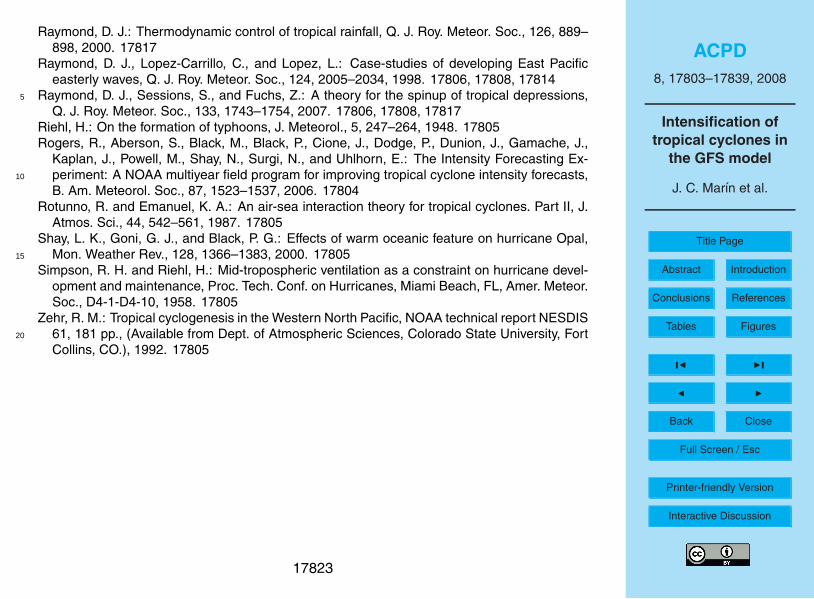
specific humidity, geopotential, etc.) from 1000 to 100 hPa and at the surface (10-mwind components, 2-m relative humidity, temperature and specific humidity, surfacefluxes, etc.) at a horizontal resolution of 1◦×1◦. Two tropical storms that developed inthe East Pacific and three hurricanes that developed in the Atlantic basin were chosenfor this study (Fig. 1). They were analyzed in a 4◦×4◦ square box centered on each25
system, which was identified from the surface wind field. The analysis included the
17807
ACPD8, 17803–17839, 2008
Intensification oftropical cyclones in
the GFS model
J. C. Marın et al.
Title Page
Abstract Introduction
Conclusions References
Tables Figures
J I
J I
Back Close
Full Screen / Esc
Printer-friendly Version
Interactive Discussion
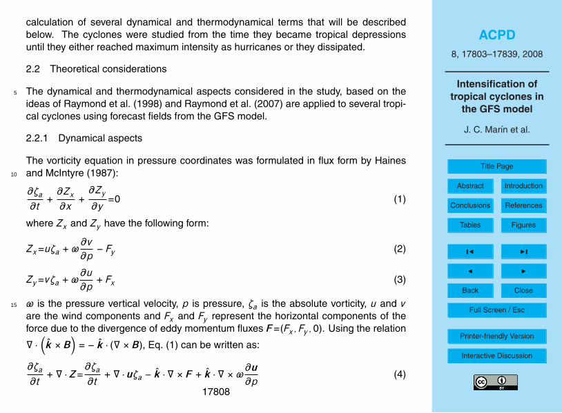
calculation of several dynamical and thermodynamical terms that will be describedbelow. The cyclones were studied from the time they became tropical depressionsuntil they either reached maximum intensity as hurricanes or they dissipated.
2.2 Theoretical considerations
The dynamical and thermodynamical aspects considered in the study, based on the5
ideas of Raymond et al. (1998) and Raymond et al. (2007) are applied to several tropi-cal cyclones using forecast fields from the GFS model.
2.2.1 Dynamical aspects
The vorticity equation in pressure coordinates was formulated in flux form by Hainesand McIntyre (1987):10
∂ζa∂t
+∂Zx
∂x+
∂Zy
∂y=0 (1)
where Zx and Zy have the following form:
Zx=uζa +ω∂v∂p
− Fy (2)
Zy=vζa +ω∂u∂p
+ Fx (3)
ω is the pressure vertical velocity, p is pressure, ζa is the absolute vorticity, u and v15
are the wind components and Fx and Fy represent the horizontal components of theforce due to the divergence of eddy momentum fluxes F=(Fx, Fy ,0). Using the relation
∇ ·(k × B
)= − k · (∇ × B), Eq. (1) can be written as:
∂ζa∂t
+ ∇ · Z=∂ζa∂t
+ ∇ · uζa − k · ∇ × F + k · ∇ ×ω∂u∂p
(4)
17808
ACPD8, 17803–17839, 2008
Intensification oftropical cyclones in
the GFS model
J. C. Marın et al.
Title Page
Abstract Introduction
Conclusions References
Tables Figures
J I
J I
Back Close
Full Screen / Esc
Printer-friendly Version
Interactive Discussion
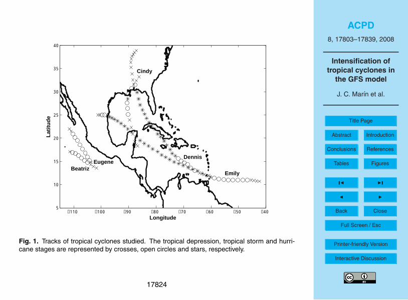
u=(u, v) is the horizontal wind velocity and Z=(Zx, Zy ). If Eq. (4) is integrated over a4◦×4◦ area that encompasses the cyclone area at all levels (Fig. 2), and the divergenceand Stokes theorems and the relation
dΓ∗a
dt=
ddt
(∫AζadA
)(5)
are applied (* refers to the 4◦×4◦ area), the following equation is obtained:5
dΓ∗a
dt= −
∮δA∗
ζauoutds −∮δA∗
ω∂u∂p
· tds +∮δA∗
F · tds (6)
where Γ∗a is the absolute circulation, uout=u·n and utan=u·t (used below) are the normal
and tangential components of the wind (u) to the area element δA∗ over the study areaA∗, and t and n are unit vectors (Fig. 2). Equation (6) shows that the spinup of thetropical cyclone (positive absolute circulation tendency) depends on the convergence10
of the absolute vorticity into the system at each level and the line integral of verticaladvection of momentum and of friction around area A∗.
The absolute circulation, the detrained (4∗) and vertical (M∗) mass fluxes are calcu-lated from the following expressions:
Γ∗a=
∮δA∗
utands + A∗f=∫A∗
(∂v∂x
− ∂u∂y
)dA + A∗f (7)15
4∗=∮δA∗
uoutds=∫A∗
(∂u∂x
+∂v∂y
)dA (8)
M∗(z)= −∫ z
0ρ4∗dz (9)
where f is the Coriolis parameter and ρ is the air density.The force per unit mass F in Eq. (6) is determined as the vertically averaged drag
force per unit mass due to surface friction and is calculated with the bulk formula: F=−20
17809

ACPD8, 17803–17839, 2008
Intensification oftropical cyclones in
the GFS model
J. C. Marın et al.
Title Page
Abstract Introduction
Conclusions References
Tables Figures
J I
J I
Back Close
Full Screen / Esc
Printer-friendly Version
Interactive Discussion
CDusus/d . The bulk transfer coefficient (CD) is obtained as described in Appendix A.The parameter d is the assumed boundary layer depth and us is the wind speed atthe surface. However, the depth over which friction is distributed in the model is notknown. Therefore, this bulk friction should be considered an approximation in whichwe assume a d=1 km boundary layer depth (approximately the 1000–900 hPa layer).5
2.2.2 Thermodynamic aspects
The specific moist entropy s (calculated from Emanuel, 1994) obeys the following equa-tion in pressure coordinates:
∂s∂t
+ ∇ · (us) +∂(ωs)
∂p=S0 (10)
where u is the horizontal velocity relative to the possibly moving target of the budget10
analysis (such as a tropical cyclone), ω is the pressure vertical velocity, and S0 is theentropy source term, containing the effects of surface fluxes, radiation flux divergenceand irreversible generation. Mass continuity is given by:
∇ · (u) +∂ω∂p
=0 (11)
If the equations are averaged over the area A∗ shown in Fig. 2 (indicated by angle15
brackets 〈 〉), the entropy equation becomes
∂ 〈s〉∂t
+1A∗
∮su · ndl +
∂ 〈ωs〉∂p
= 〈S0〉 (12)
where the divergence theorem has been used. The moist entropy s is now divided intotwo parts: s=s + s′ where s is the average of s around the loop at each pressure level
17810

ACPD8, 17803–17839, 2008
Intensification oftropical cyclones in
the GFS model
J. C. Marın et al.
Title Page
Abstract Introduction
Conclusions References
Tables Figures
J I
J I
Back Close
Full Screen / Esc
Printer-friendly Version
Interactive Discussion
and s′ is the deviation from this average. Substituting s into the integral of Eq. (12)results in:
∂ 〈s〉∂t
+sA∗
∮u · ndl + 1
A∗
∮s′u · ndl +
∂ 〈ωs〉∂p
= 〈S0〉 (13)
Using the mass continuity and the divergence equation, the second term in Eq. (13)can be written as:5
sA∗
∮u · ndl= − s
∂ 〈ω〉∂p
= −∂⟨ωs
⟩∂p
+ 〈ω〉 ∂s∂p
(14)
Substituting Eq. (14) into Eq. (13), it results in:
∂ 〈s〉∂t
+ 〈ω〉 ∂s∂p
+1A∗
∮s′u · ndl +
∂⟨ωs′
⟩∂p
= 〈S0〉 (15)
Finally, Eq. (15) is integrated over the depth of the troposphere, indicating this bysquare brackets [ ]:10 [∂ 〈s〉∂t
]=[− 〈ω〉 ∂s
∂p
]+ [−Vs] +
[〈S0〉
](16)
Vs is defined as the entropy ventilation:
Vs=1A∗
∮s′u · ndl (17)
It has been assumed that[∂⟨ωs′
⟩/∂p=0
]since
⟨ωs′
⟩should be approximately zero
at the surface and the tropopause.15
The first term in Eq. (16) is the mean moist entropy tendency inside the volumedefined by the line integral, the surface and the tropopause. The second term is theentropy tendency due to minus the vertical advection of entropy. The third term is minus
17811
ACPD8, 17803–17839, 2008
Intensification oftropical cyclones in
the GFS model
J. C. Marın et al.
Title Page
Abstract Introduction
Conclusions References
Tables Figures
J I
J I
Back Close
Full Screen / Esc
Printer-friendly Version
Interactive Discussion
the contribution to the entropy tendency by ventilation through the sides of the box. Ver-tical advection of entropy and the ventilation tendency will refer to terms
[− 〈ω〉∂s/∂p
]and [−Vs], respectively in Sect. 3.2. A negative ventilation tendency will correspond tothe replacement of high entropy air inside the box by air with lower entropy.
The surface entropy flux was calculated with the following bulk formula:5
Fes=[ρCDUBL(sss − sBL)]g/∆p (18)
where ρ is the air density, CD is the bulk transfer coefficient calculated from Appendix A,UBL and sBL are the wind speed and the specific moist entropy, respectively, averagedover the first two model levels (1000 and 975 hPa) and sss is the saturated specificentropy at the sea surface temperature (SST) and mean sea level pressure (MSLP).10
The entropy flux was divided by ∆p/g to obtain its average over the depth of the tro-posphere as expressed by Eq. (16), where ∆p is 900 hPa and g is the acceleration ofgravity. The effects of radiation flux divergence and irreversible generation of entropycontained in the
[〈S0〉
]term in Eq. (16) are not considered here.
3 Results15
Results from the vorticity balance analysis for two tropical cyclone cases are describedin Sect. 3.1: one that intensified and another that did not intensify into a hurricane.These cases are representative of all the cases analyzed. Results from the thermody-namic analysis are shown in Sect. 3.2.
3.1 Vorticity balance20
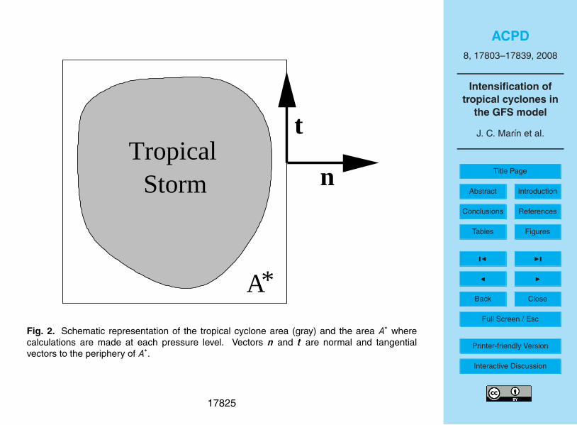
Equation (6), averaged over the 1000–900 hPa layer, was analyzed for all cases. Fig-ures 3 and 4 show this analysis for hurricane Dennis, which developed in the Caribbeanregion, and tropical storm Eugene which formed in the East Pacific. Vertical solid lines
17812
ACPD8, 17803–17839, 2008
Intensification oftropical cyclones in
the GFS model
J. C. Marın et al.
Title Page
Abstract Introduction
Conclusions References
Tables Figures
J I
J I
Back Close
Full Screen / Esc
Printer-friendly Version
Interactive Discussion
show the times when cyclones reach their different development stages, obtained fromthe NHC archives.
The circulation tendencies due to the convergence of absolute vorticity and to friction(related to the sub-grid scale turbulent momentum transfer due to deep convectiveand atmospheric boundary layer processes) are, in general, larger than the tendency5
due to the vertical advection of momentum; nonetheless, the influence of the lattercannot be neglected, specifically in intensifying tropical cyclones. The convergence ofabsolute vorticity causes the cyclones to intensify, while friction and vertical advectionof momentum tend to decrease their intensity. Therefore, a positive Γa tendency isobserved when convergence of absolute vorticity is larger than the sum of those two10
negative terms.Intensification in Dennis and Eugene is accompanied by a marked increase in con-
vergence of absolute vorticity in the PBL, which is larger in the hurricane than in thetropical storm stage (Figs. 3 and 4). This is mainly the result of an increase in thehorizontal mass flux into the cyclones, as Figs. 5 and 6 show. However, the absolute15
vorticity at the cyclone’s boundary can significantly exceed the value of the Coriolisparameter. This factor is therefore responsible for some part of the spinup in manycases. In both Dennis and Eugene the convergence of vorticity is nearly in balancewith the effects of surface friction and the vertical advection of momentum. The netspinup tendency is thus typically a small residual in the circulation equation. This is20
in agreement with the order of magnitude of the observed time rate of change of cir-culation. Due to the uncertainties in how the Reynolds stress divergence associatedwith surface friction is distributed vertically in the model and other factors, we can notexpect the calculated residual circulation tendency to reflect in detail the actual changein circulation of the system with time.25
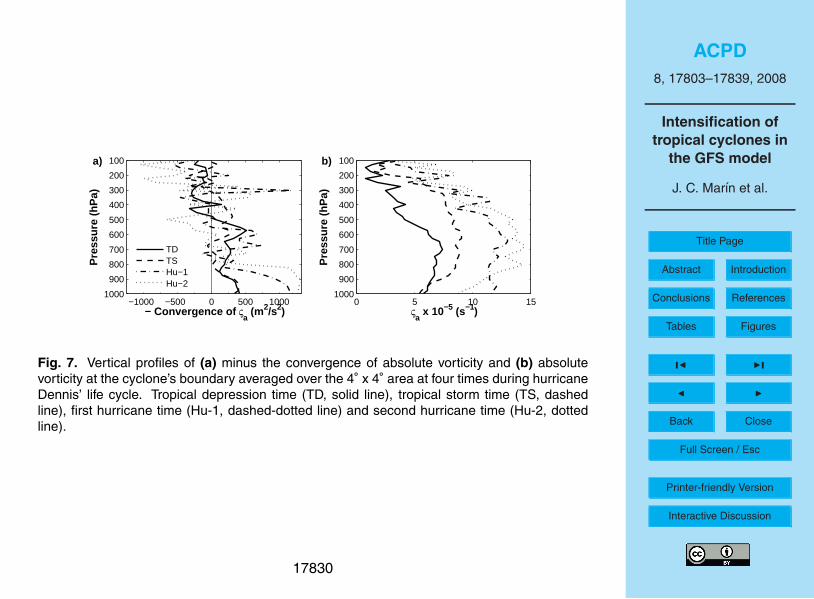
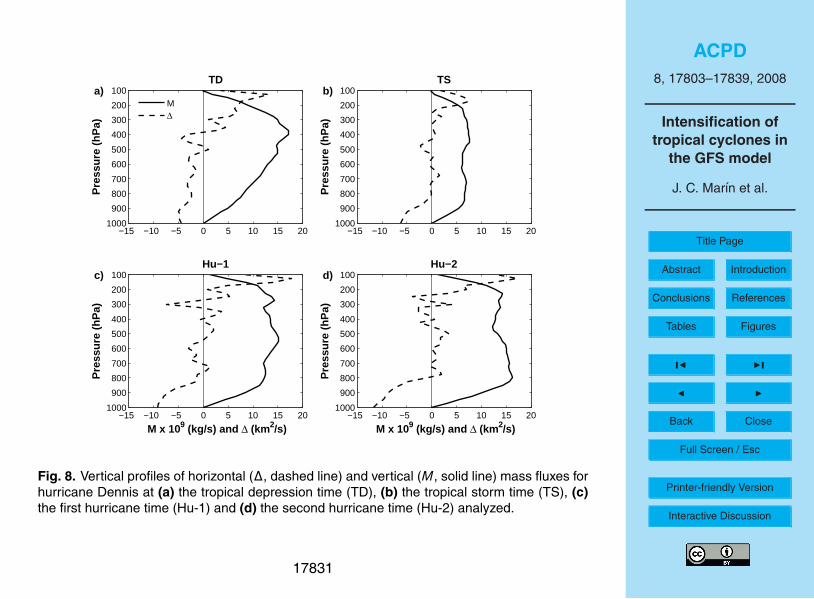
Figure 7a shows the vertical profiles of convergence of absolute vorticity at fourstages during the evolution of Dennis (indicated by the horizontal arrows in Fig. 3). Theintensification from the tropical depression to the hurricane stage is characterized by alarge increase in vorticity convergence at low levels partly as a result of an increase in
17813
ACPD8, 17803–17839, 2008
Intensification oftropical cyclones in
the GFS model
J. C. Marın et al.
Title Page
Abstract Introduction
Conclusions References
Tables Figures
J I
J I
Back Close
Full Screen / Esc
Printer-friendly Version
Interactive Discussion
the horizontal mass inflow there (Fig. 8) and partly due to an increase in the absolutevorticity of the air being ingested. Corresponding to this is a lowering of the level ofthe maximum vertical mass flux, a phenomenon observed in actual tropical cyclones(Raymond et al., 1998).
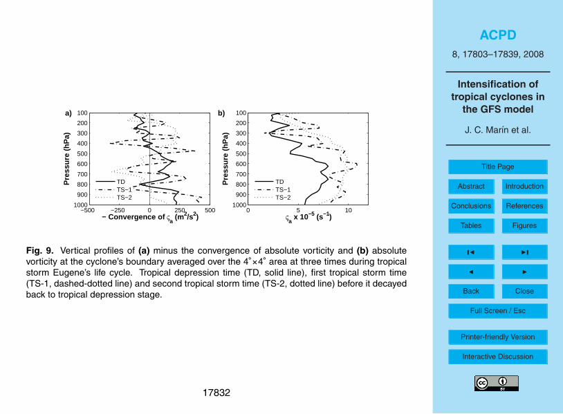
Three times (indicated by arrows in Fig. 4) were analyzed in the evolution of Eugene.5
The intensification from tropical depression to tropical storm shows an increase in con-vergence of absolute vorticity at low levels for the first day, with maximum values inthe layer 1000–900 hPa (Fig. 9a). However, the vorticity convergence decreases dras-tically thereafter as the system decays. Thus, as with Dennis and the other systems,intensification is intimately related to the convergence of vorticity in the GFS. We now10
examine the factors controlling this convergence.
3.2 Entropy balance
In order to gain a better understanding of the processes that cause some systemsto intensify into a hurricane and others not to intensify, the thermodynamic analysisdescribed in Sect. 2.2 is applied below to the five cases studied.15
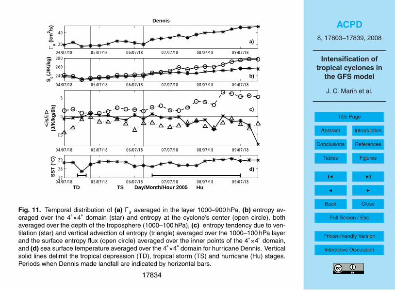
3.2.1 Hurricane Dennis
With minor exception, the circulation in the PBL around the numerically simulated At-lantic hurricane Dennis increases monotonically through the entire period considered,as Fig. 11 shows. For most of the period the SST exceeds 28.5◦C and for the firstthree days the ventilation tendency is near zero, with mostly weak negative values20
thereafter. The surface entropy flux increases in step with the circulation, as does theaverage moist entropy within the system. The entropy tendency due to vertical ad-vection is negative for most of the period, with a magnitude generally somewhat lessthan the tendency due to surface entropy fluxes. Thus, surface entropy fluxes are high,ventilation is minimal, and Dennis intensifies into a major hurricane.25
17814

ACPD8, 17803–17839, 2008
Intensification oftropical cyclones in
the GFS model
J. C. Marın et al.
Title Page
Abstract Introduction
Conclusions References
Tables Figures
J I
J I
Back Close
Full Screen / Esc
Printer-friendly Version
Interactive Discussion
3.2.2 Tropical storm Eugene
In contrast, the circulation around East Pacific tropical storm Eugene (see Fig. 12) in-creases until shortly after it attains tropical storm category and decreases thereafter.The ventilation tendency is near zero up to the time of peak circulation and exhibitsincreasingly negative episodes thereafter. However, the most important factor in the5
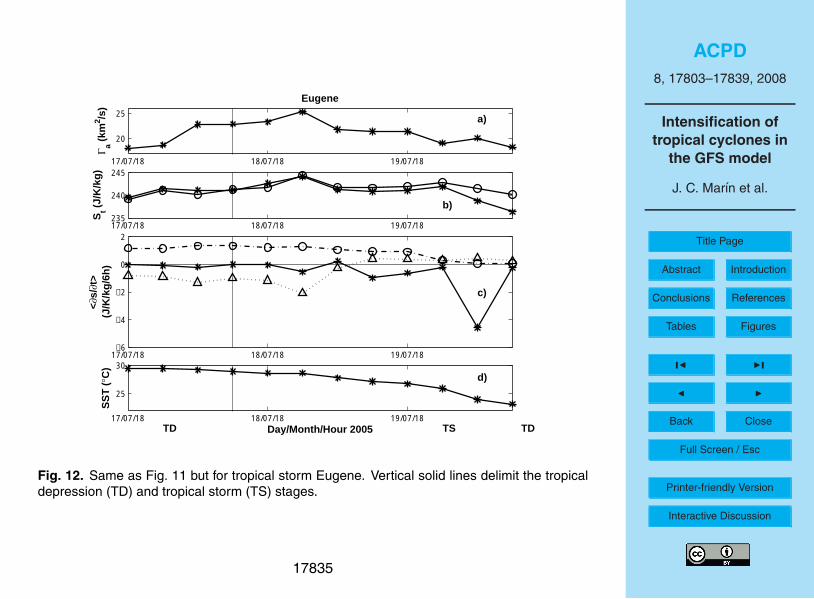
decay of the simulated Eugene is likely to be the drastic decrease in SST which com-mences just after the time of peak circulation. The entropy tendency due to verticaladvection is negative up to the time of maximum circulation, gradually changing topositive thereafter. Mean entropy peaks at the time of maximum circulation.
3.2.3 Tropical storm Beatriz10
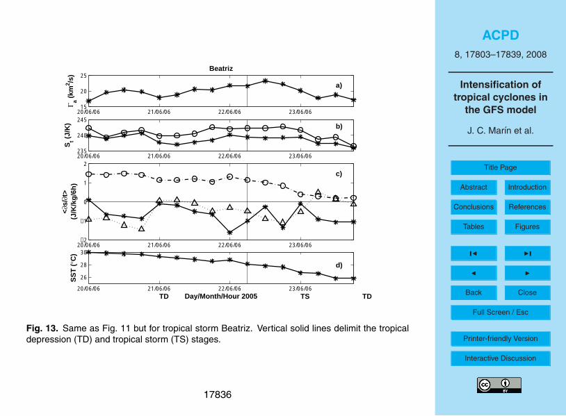
East Pacific tropical storm Beatriz presents a more complex case in that both ventilationand reduced SSTs appear to play an important role in its development and decay. Forthe first two days presented in Fig. 13 the SST experienced by Beatriz in the model ex-ceeds 28◦C. However, the circulation only increases when the ventilation is weak nearthe very beginning of the first day and most of the second day. After the second day15
more rapidly decreasing SSTs and episodes of strong ventilation are correlated withdecreasing PBL circulation. The decreasing SSTs correspond to strongly decreasingsurface entropy fluxes during this latter phase.
3.2.4 Hurricane Cindy
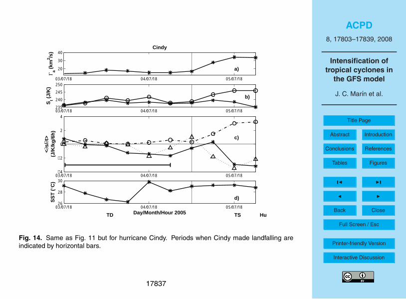
Atlantic hurricane Cindy is also affected by both strong SST variations and variations in20
ventilation in the model. Examination of Fig. 14 shows that Cindy fails to intensify wheneither SST values are low or ventilation tendencies are strongly negative, or both. Onlyduring the second day displayed in this figure when SSTs exceed 29◦C and the venti-lation relaxes for a short period does the storm circulation increase significantly. Thiscase illustrates in particular the powerful effect of ventilation in limiting intensification,25
17815
ACPD8, 17803–17839, 2008
Intensification oftropical cyclones in
the GFS model
J. C. Marın et al.
Title Page
Abstract Introduction
Conclusions References
Tables Figures
J I
J I
Back Close
Full Screen / Esc
Printer-friendly Version
Interactive Discussion
even in the presence of high SSTs.
3.2.5 Hurricane Emily
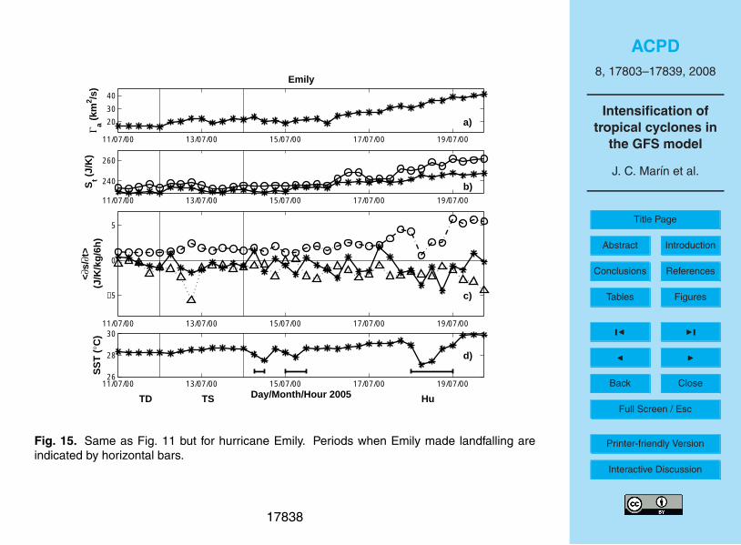
Atlantic hurricane Emily shows an evolution which is rather similar to that of Dennis(Fig. 15). SSTs generally exceed 28◦C except for some minor episodes, increasing to30◦C near the end of the period studied. Ventilation is slightly stronger than for Dennis,5
but significantly weaker than for Beatriz and Cindy. Strengthening of the circulation isslow for the first couple of days, but it then accelerates as Emily intensifies into a majorhurricane. The entropy tendency associated with vertical advection fluctuates, but isgenerally negative over the period studied.
4 Discussion and conclusions10
Forecast output from the GFS model was used in this study to investigate the differentatmospheric mechanisms that favor the intensification of tropical cyclones into hurri-canes and those responsible for halting intensification. Several cases were analyzedbased on the vorticity and entropy balance equations, corroborating the strong influ-ence of sea-air entropy fluxes and ventilation by environmental air on tropical cyclones.15
In addition, quantitative measures of the influence of these factors are introduced.The convergence of absolute vorticity favors the intensification while friction and ver-
tical advection of momentum act to decrease it in the GFS model. Intensification isaccompanied by a large increase in convergence of absolute vorticity at low and mid-levels, which is the result of strong horizontal mass inflow and large absolute vorticity20
at the cyclone boundary. Unfortunately, our diagnostic methods are insufficiently ac-curate to show quantitatively that vorticity convergence exceeds friction and verticalmomentum advection during intensification and the opposite during dissipation; theseterms are typically close to balance with the actual circulation tendency being a smallresidual, but there is little doubt that this is occurring. The small value of the circulation25
17816
ACPD8, 17803–17839, 2008
Intensification oftropical cyclones in
the GFS model
J. C. Marın et al.
Title Page
Abstract Introduction
Conclusions References
Tables Figures
J I
J I
Back Close
Full Screen / Esc
Printer-friendly Version
Interactive Discussion
tendency relative to the other terms indicates that the modeled systems remain veryclose to Ekman balance throughout their simulated life cycles.
Convergence of absolute vorticity and horizontal mass inflow in the model concen-trate in a shallower layer as a tropical cyclone intensifies. As a result, the level ofnon-divergence and peak vertical mass flux decrease in height. The absolute vorticity5
at the cyclone’s boundary increases at all heights with intensification.The theoretical analysis of Raymond et al. (2007) highlights the key role played by
precipitation in the intensification of tropical cyclones. Precipitation is associated withlatent heat release which is most intense in the lower troposphere. This in turn iscorrelated with ascending motion, and hence convergence in the lower troposphere.10
Significant evidence has accumulated indicating that rainfall over tropical oceansis controlled to a large degree by the saturation fraction (precipitable water divided bysaturated precipitable water) of the tropospheric column. In the tropics the temperatureprofile of the troposphere varies minimally, which means that the moist entropy profileis closely related to the saturation fraction. We analyze the moist entropy budget for15
this reason.Following Neelin and Held (1987) and Raymond (2000), we note that the time ten-
dency of moist entropy in the troposphere has terms related to the surface entropy flux,the radiative loss of entropy at the tropopause, and the lateral import or export of en-tropy. The last can be split into two terms, a part associated with the vertical advection20
of entropy in the troposphere and a part associated with the horizontal advection ofenvironmental air through the cyclone, which we call the ventilation tendency. The firstterm is closely related to Neelin and Held’s gross moist stability (GMS).
The vertical advection tendency is generally positive when ascent is concentratedin the lower troposphere where the vertical gradient of environmental moist entropy is25
negative, whereas it is negative when ascent is concentrated in the upper tropospherewhere the gradient is positive. In the former case the GMS is negative, in the latter it ispositive according to Neelin and Held’s definition. Examination of Figs. 11 through 15suggests that the vertical advection tendency is negative when a cyclone is intensifying,
17817
ACPD8, 17803–17839, 2008
Intensification oftropical cyclones in
the GFS model
J. C. Marın et al.
Title Page
Abstract Introduction
Conclusions References
Tables Figures
J I
J I
Back Close
Full Screen / Esc
Printer-friendly Version
Interactive Discussion
but tends to zero or slightly positive 6–12 h after decay commences. This suggeststhat a transition from deep to shallow (but still precipitating) convection occurs when acyclone begins to decay.
The two external environmental factors which affect the moist entropy budget in themodel are the SST, which enters into the sea-air entropy fluxes, and the environmen-5
tal wind profile measured relative to the moving cyclone, which drives the ventilation.The vertical entropy advection tendency also has a large effect on the entropy budgetwithin the cyclone, but is presumably a response to environmental factors rather thanan environmental driver itself. Examination of Figs. 11–15 suggests that these twoenvironmental factors can indeed explain the behavior of the five modeled cyclones:10
– Dennis and Emily experience high SSTs and weak ventilation compared to sea-air moist entropy fluxes throughout the intervals considered, and both amplify intomajor hurricanes.
– For the first day Eugene intensifies under the influence of high SSTs and weakventilation. Subsequently SSTs decrease dramatically and ventilation progres-15
sively strengthens. Simultaneously intensification stops and decay sets in.
– Beatriz experiences high SSTs for the first two days but is episodically subjectedto moderate to strong ventilation relative to the computed surface entropy fluxes.Episodes of intensification appear to be related to periods in which ventilationrelaxes. After 2.5 d decay sets in, probably as a result of diminishing surface20
entropy fluxes associated with decreasing SSTs.
– Cindy remains weak for 1.5 d in conjunction with a period of low SSTs and venti-lation which is strong relative to surface entropy fluxes. Only when this ventilationdecreases in magnitude does Cindy intensify.
That low SST and strong ventilation by environmental air appear to be the primary25
factors inhibiting tropical cyclone intensification will come as no surprise. However, twopoints make these results worth reporting:
17818

ACPD8, 17803–17839, 2008
Intensification oftropical cyclones in
the GFS model
J. C. Marın et al.
Title Page
Abstract Introduction
Conclusions References
Tables Figures
J I
J I
Back Close
Full Screen / Esc
Printer-friendly Version
Interactive Discussion
1. We have documented this behavior in NCEP’s GFS model, which is one of theprincipal models used by cyclone forecasters around the world.
2. Casting these factors in terms of tendencies in the moist entropy budget equationallows the importance of these factors to be evaluated quantitatively rather than onan ad-hoc basis. Hopefully this diagnostic tool can be extended to other models5
and to the real world in the study of tropical cyclone behavior.
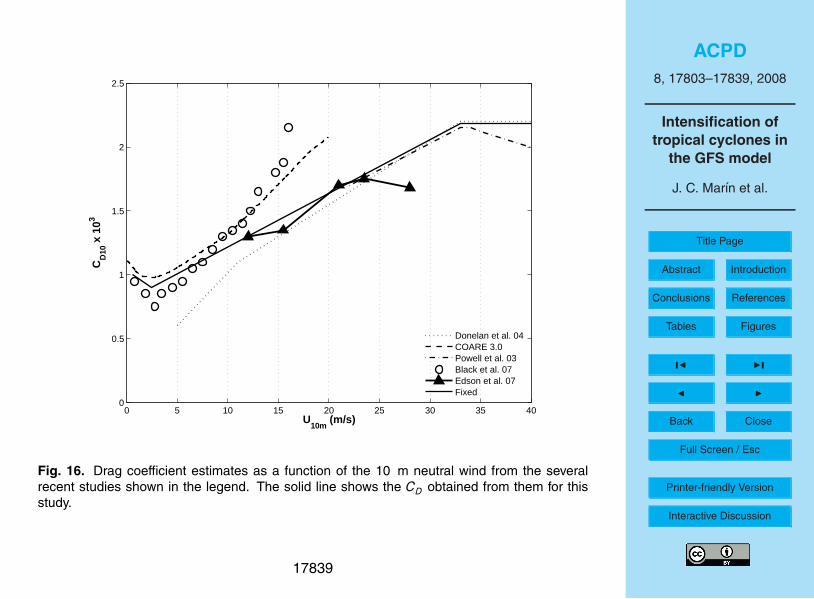
Appendix A
Figure 16 shows drag coefficient estimates as a function of neutral wind speed at 10 mfrom several recent studies, modified from Fig. 5 in Black et al. (2007). The COARE3.0 (Fairall et al., 2003) and Edson et al. (2007) estimations were obtained for open-10
sea conditions from low to moderate wind speed regimes (0–20 m/s) and show a goodagreement between them. A drop in CD with the increase in wind speed is observedfor very low wind values, characteristic of a smooth aerodynamical surface becomingrougher for wind speeds larger than 3 m/s with the corresponding increase in CD. Otherstudies have focused on the CD behavior under strong wind speed conditions, relevant15
to tropical storms and hurricanes (Powell et al., 2003; Donelan et al., 2004; Black etal., 2007). The fundamental result from these studies is that CD stops increasing ata specific wind speed value and it behaves nearly constant for larger wind speeds. Athreshold value of approximately 33 m/s is obtained by Donelan et al. (2004) and Powellet al. (2003) using laboratory measurements and wind sonde profiles inside storms,20
respectively. A lower threshold value of near 23 m/s is estimated by Black et al. (2007)from CBLAST (Coupled Boundary Layer Air-Sea Transfer) in-situ measurements insidehurricanes in the Atlantic ocean.
Wind speed values from GFS forecasts range from near zero to approximately 40 m/sfor the different tropical cyclones analyzed. A piecewise estimate of CD as a function25
of wind speed was obtained graphically from Fig. 16 (solid line) and used to estimate
17819
ACPD8, 17803–17839, 2008
Intensification oftropical cyclones in
the GFS model
J. C. Marın et al.
Title Page
Abstract Introduction
Conclusions References
Tables Figures
J I
J I
Back Close
Full Screen / Esc
Printer-friendly Version
Interactive Discussion
the bulk fluxes in this study:
CD10 m=[−0.053u10 m + 1.03] · 10−3 for 0 ≤ u10 m < 2.5 m/sCD10 m=[0.042u10 m + 0.8] · 10−3 for 2.5 m/s ≤ u10 m < 33 m/sCD10 m=2.18 · 10−3 for 33 m/s ≤ u10 m < 40 m/s
(A1)
Acknowledgements. This work was carried out with the aid of a grant from the Inter-AmericanInstitute for Global Change Research (IAI) CRN II # 2048 which is supported by the US NationalScience Foundation (Grant GEO-0452325). JCM acknowledges support by a scholarship from5
the Direccion General de Estudios de Posgrado, UNAM. DJR was supported by US NationalScience Foundation Grant ATM-0352639.
References
Aberson, S. D.: The ensemble of tropical cyclone track forecasting models in the North AtlanticBasin (1976–2000), B. Am. Meteorol. Soc., 82, 1895–1904, 2001. 1780410
Black, M. L., Gamache, J. F., Marck Jr., F. D., Samsury, C. E., and Willoughby, H. E.: EasternPacific hurricanes Jimena of 1991 and Olivia of 1994: The effect of vertical shear on structureand intensity, Mon. Weather Rev., 130, 2291–2312, 2002. 17805
Black, P. G., D’Asaro, E. A., Drennan, W. M., French, J. R., Niiler, P. P., Sanford, T. B., Terrill, E.J., Walsh, E. J., and Zhang, J. A.: Air–sea exchange in hurricanes: synthesis of observations15
from the Coupled Boundary Layer Air-Sea Transfer Experiment, B. Am. Meteorol. Soc., 88,357–374, 2007. 17819
Burpee, R. W., Aberson, S. D., Franklin, J. L., Lord, S. J., and Tuleya, R. E.: The impact ofomega dropwindsondes on operational hurricane track forecast models, B. Am. Meteorol.Soc., 77, 925–933, 1996. 1780420
Challa, M. and Pfeffer, R. L.: Effects of eddy fluxes of angular momentum on model hurricanedevelopment, J. Atmos. Sci., 37, 1603–1618, 1980. 17805
Challa M., Pfeffer, R. L., Zhao, Q., and Chang, S. W.: Can eddy fluxes serve as a catalyst forhurricane and typhoon formation?, J. Atmos. Sci., 55, 2201–2219, 1998. 17805
Corbosiero, K. L. and Molinari, J.: The effects of vertical wind shear on the distribution of25
convection in tropical cyclones, Mon. Weather Rev., 130, 2110–2123, 2002. 1780517820

ACPD8, 17803–17839, 2008
Intensification oftropical cyclones in
the GFS model
J. C. Marın et al.
Title Page
Abstract Introduction
Conclusions References
Tables Figures
J I
J I
Back Close
Full Screen / Esc
Printer-friendly Version
Interactive Discussion
Corbosiero, K. L. and Molinari, J.: The relationship between storm motion, vertical wind shear,and convective asymmetries in tropical cyclones, J. Atmos. Sci., 60, 366–460, 2003. 17805
DeMaria, M., Mainelli, M., Shay, L. K., Knaff, J. A., and Kaplan, J.: Further improvements to theStatistical Hurricane Intensity Prediction Scheme (SHIPS), Weather Forecast., 20, 531–543,2005. 178045
Donelan, M. A., Haus, B. K., Reul, N., Plant, W. J., Stianssnie, M., Graber, H. C., Brown, O.B., and Saltzman, E. S.: On the limiting aerodynamic roughness of the ocean in very strongwinds, Geophys. Res. Lett., 31, L18306, doi:10.1029/2004GL019460, 2004. 17819
Edson, J., Crawford, T., Crescenti, J., Farrar, T., Frew, N., Gerbi, G., Helmis, C., Hristov, T.,Khelif, D., Jessup, A., Jonsson, H., Li, M., Mahrt, L., McGillis, W., Plueddemann, A., Shen,10
L., Skyllingstad, E., Stanton, T., Sullivan, P., Sun, J., Trowbridge, J., Vickers, D., Wang, S.,Wang, Q., Weller, R., Wilkin, J., Williams, A.J., Yue, D. K. P., and Zappa, C.,: The CoupledBoundary Layers and Air–Sea Transfer experiment in low winds, B. Am. Meteorol. Soc., 88,341–356, 2007. 17819
Elsberry, R. L., Emanuel, K. A., Holland, G., Gerrish, H., DeMaria, M., and Guard, C.: Is there15
any hope for tropical cyclone intensity prediction? A panel discussion, B. Am. Meteorol. Soc.,73, 264–275, 1992. 17804, 17805
Emanuel, K. A.: An air-sea interaction theory for tropical cyclones. Part I, J. Atmos. Sci. 42,1062–1071, 1986. 17805
Emanuel, K. A.: The finite-amplitude nature of tropical cyclogenesis, J. Atmos. Sci., 46, 3431–20
3456, 1989. 17805Emanuel, K. A.: Atmospheric convection, Oxford University Press, 580 pp., 1994. 17810Emanuel, K., DesAutels, C., Holloway, C., and Korty, R.: Environmental control of tropical
cyclone intensity, J. Atmos. Sci., 61, 843–858, 2004. 17805Fairall, C. W., Bradley, E. F., Hare, J. E., Grachev, A. A., and Edson, J. B.: Bulk parameterization25
of air-sea fluxes: Updates and verification for the COARE algorithm, J. Climate, 16, 571–591,2003. 17819
Frank, W. M. and Ritchie, E. A.: Effects of environmental flow upon tropical cyclone structure,Mon. Weather Rev., 127, 2044–2061, 1999. 17805
Frank, W. M. and Ritchie, E. A.: Effects of vertical wind shear on the intensity and structure of30
numerically simulated hurricanes, Mon. Weather Rev., 129, 2249–2269, 2001. 17805Global Climate and Weather Modeling Branch, EMC.: The GFS atmospheric model, NCEP
Office Note 442, 14 pp., 2003.
17821

ACPD8, 17803–17839, 2008
Intensification oftropical cyclones in
the GFS model
J. C. Marın et al.
Title Page
Abstract Introduction
Conclusions References
Tables Figures
J I
J I
Back Close
Full Screen / Esc
Printer-friendly Version
Interactive Discussion
Global Climate and Weather Modeling Branch, EMC.: Near-surface data assimilation in theNCEP Gridpoint Statistical-Interpolation System: Use of land temperature data and a com-prehensive forward model, NCEP Office Note 446, 46 pp., 2005.
Gray, W. M.: Global view of the origin of tropical disturbances and storms, Mon. Weather Rev.,96, 669–700, 1968. 178055
Haines, P. H. and McIntyre, M. E.: On the evolution of vorticity and potential vorticity in thepresence of diabatic heating and frictional or other forces, J. Atmos. Sci., 44, 828–841, 1987.17808
Hanley, D. E., Molinari, J., and Keyser, D.: A composite study of the interaction between trop-ical cyclones and upper-tropospheric troughs, Mon. Weather Rev., 129, 2570–2584, 2001.10
17806Hong, X., Chang, S. W., Raman, S., Shay, L. K., and Hodur, R.: The interaction between
hurricane Opal (1995) and a warm core ring in the Gulf of Mexico, Mon. Weather Rev., 128,1347–1365, 2000. 17805
Knaff, J. A. and Weaver, J. F.: A mesoscale low-level thunderstorm outflow boundary associated15
with hurricane Luis, Mon. Weather Rev., 128, 3352–3355, 2000. 17805Marks, F. D. and Shay, L. K.: Landfalling tropical cyclones: Forecast problems and associated
research opportunities, B. Am. Meteorol. Soc., 79, 867–876, 1998. 17804McBride, J. L. and Zehr, R.: Observational analysis of tropical cyclone formation. Part II: Com-
parison of nondeveloping versus developing systems, J. Atmos. Sci., 38, 1132–1151, 1981.20
17805Molinari, J. and Vollaro, D.: External influences on hurricane intensity, Part I: Outflow layer eddy
angular momentum fluxes, J. Atmos. Sci., 46, 1093–1105, 1989. 17805Molinari, J., Skubis, S., and Vollaro, D.: External influences on hurricane intensity. Part III:
Potential vorticity structure, J. Atmos. Sci., 52, 3593–3606, 1995. 1780625
Neelin, J. D. and Held, I. M.: Modeling tropical convergence based on the moist static energybudget, Mon. Weather Rev., 115, 3–12, 1987. 17817
Palmen, E.: On the formation and structure of tropical hurricanes, Geophysica, 3, 26–39, 1948.17805
Pfeffer, R. L. and Challa, M.: A numerical study of the role of eddy fluxes of momentum in the30
development of Atlantic hurricanes, J. Atmos. Sci., 38, 2393–2398, 1981. 17805Powell, M. D., Vickery, P. J., and Reinhold, T. A.: Reduced drag coefficient for high wind speeds
in tropical cyclones, Nature, 422, 279–283, 2003. 17819
17822
ACPD8, 17803–17839, 2008
Intensification oftropical cyclones in
the GFS model
J. C. Marın et al.
Title Page
Abstract Introduction
Conclusions References
Tables Figures
J I
J I
Back Close
Full Screen / Esc
Printer-friendly Version
Interactive Discussion
Raymond, D. J.: Thermodynamic control of tropical rainfall, Q. J. Roy. Meteor. Soc., 126, 889–898, 2000. 17817
Raymond, D. J., Lopez-Carrillo, C., and Lopez, L.: Case-studies of developing East Pacificeasterly waves, Q. J. Roy. Meteor. Soc., 124, 2005–2034, 1998. 17806, 17808, 17814
Raymond, D. J., Sessions, S., and Fuchs, Z.: A theory for the spinup of tropical depressions,5
Q. J. Roy. Meteor. Soc., 133, 1743–1754, 2007. 17806, 17808, 17817Riehl, H.: On the formation of typhoons, J. Meteorol., 5, 247–264, 1948. 17805Rogers, R., Aberson, S., Black, M., Black, P., Cione, J., Dodge, P., Dunion, J., Gamache, J.,
Kaplan, J., Powell, M., Shay, N., Surgi, N., and Uhlhorn, E.: The Intensity Forecasting Ex-periment: A NOAA multiyear field program for improving tropical cyclone intensity forecasts,10
B. Am. Meteorol. Soc., 87, 1523–1537, 2006. 17804Rotunno, R. and Emanuel, K. A.: An air-sea interaction theory for tropical cyclones. Part II, J.
Atmos. Sci., 44, 542–561, 1987. 17805Shay, L. K., Goni, G. J., and Black, P. G.: Effects of warm oceanic feature on hurricane Opal,
Mon. Weather Rev., 128, 1366–1383, 2000. 1780515
Simpson, R. H. and Riehl, H.: Mid-tropospheric ventilation as a constraint on hurricane devel-opment and maintenance, Proc. Tech. Conf. on Hurricanes, Miami Beach, FL, Amer. Meteor.Soc., D4-1-D4-10, 1958. 17805
Zehr, R. M.: Tropical cyclogenesis in the Western North Pacific, NOAA technical report NESDIS61, 181 pp., (Available from Dept. of Atmospheric Sciences, Colorado State University, Fort20
Collins, CO.), 1992. 17805
17823
ACPD8, 17803–17839, 2008
Intensification oftropical cyclones in
the GFS model
J. C. Marın et al.
Title Page
Abstract Introduction
Conclusions References
Tables Figures
J I
J I
Back Close
Full Screen / Esc
Printer-friendly Version
Interactive Discussion
−110 −100 −90 −80 −70 −60 −50 −405
10
15
20
25
30
35
40
Emily
Cindy
Dennis
BeatrizEugene
Longitude
Lat
itu
de
Fig. 1. Tracks of tropical cyclones studied. The tropical depression, tropical storm and hurri-cane stages are represented by crosses, open circles and stars, respectively.
17824
ACPD8, 17803–17839, 2008
Intensification oftropical cyclones in
the GFS model
J. C. Marın et al.
Title Page
Abstract Introduction
Conclusions References
Tables Figures
J I
J I
Back Close
Full Screen / Esc
Printer-friendly Version
Interactive Discussion
t
nTropical
Storm
A*
Fig. 2. Schematic representation of the tropical cyclone area (gray) and the area A∗ wherecalculations are made at each pressure level. Vectors n and t are normal and tangentialvectors to the periphery of A∗.
17825

ACPD8, 17803–17839, 2008
Intensification oftropical cyclones in
the GFS model
J. C. Marın et al.
Title Page
Abstract Introduction
Conclusions References
Tables Figures
J I
J I
Back Close
Full Screen / Esc
Printer-friendly Version
Interactive Discussion
04/07/18 05/07/18 06/07/18 07/07/18 08/07/18 09/07/18
20
30
40
50
Γ a (km
2 /s)
04/07/18 05/07/18 06/07/18 07/07/18 08/07/18 09/07/18
−1000
−500
0
500
1000
Day/Month/Hour 2005
Vo
rtic
ity
Bal
ance
Ter
ms
(m2 /s
2 )
TD TS Hu
← ←
← →
− CAVdΓa/dtτ BulkdΓa/dt ResVAM
Fig. 3. Hurricane Dennis. (a) Time evolution of the absolute circulation averaged in the layer1000–900 hPa. (b) Terms in the balance of Eq. (6) averaged in the layer 1000–900 hPa. Thesolid line represents minus the convergence of absolute vorticity (-CAV), line with crosses (verti-cal advection of momentum, VAM), dashed line (Γa tendency), dashed-dotted line (bulk frictionterm, τ Bulk) and dotted line (residual Γa tendency). Vertical solid lines delimit the tropicaldepression (TD), tropical storm (TS) and hurricane (Hu) stages as determined by the NHC.Periods when Dennis made landfall are indicated by horizontal bars. Arrows indicate certaintimes that will be discussed in the text and in Figs. 7 and 8.
17826
ACPD8, 17803–17839, 2008
Intensification oftropical cyclones in
the GFS model
J. C. Marın et al.
Title Page
Abstract Introduction
Conclusions References
Tables Figures
J I
J I
Back Close
Full Screen / Esc
Printer-friendly Version
Interactive Discussion
17/07/18 18/07/18 19/07/18
18
20
22
24
26Γ a (
km2 /s
)
17/07/18 18/07/18 19/07/18
−200
−100
0
100
200
300
Day/Month/Hour 2005
Vo
rtic
ity
Bal
ance
Ter
ms
(m2 /s
2 )
TD TS TD
←
←
→
− CAVdΓa/dtτ BulkdΓa/dt ResVAM
Fig. 4. Same as Fig. 3 but for tropical storm Eugene. Vertical solid lines delimit the tropicaldepression (TD) and tropical storm (TS) stages. Arrows indicate certain times that will bediscussed in the text and in Figs. 9 and 10.
17827

ACPD8, 17803–17839, 2008
Intensification oftropical cyclones in
the GFS model
J. C. Marın et al.
Title Page
Abstract Introduction
Conclusions References
Tables Figures
J I
J I
Back Close
Full Screen / Esc
Printer-friendly Version
Interactive Discussion
04/07/18 05/07/18 06/07/18 07/07/18 08/07/18 09/07/18
10
20
30
40
50
60
70
80
90
100
110
− Δ
x 10
5 (m
2 /s),
ςa x
105 (
s−1)
and
f x
105 (
s−1)
Day/Month/Hour 2005
TD TS Hu
04/07/18 05/07/18 06/07/18 07/07/18 08/07/18 09/07/180
250
500
750
1000
1250
− C
on
verg
ence
of ς
a (m
2 /s2 )
Fig. 5. Time evolution of minus the convergence of absolute vorticity (solid line), −4 (dottedline), and the absolute vorticity at the cyclone’s boundary (ςa) (dashed-dotted line) averagedover the 1000–900 hPa for hurricane Dennis. The line with crosses represents the Coriolis pa-rameter at Dennis’s central latitude. The absolute vorticity and Coriolis were multiplied by 4 fora better comparison with the other variables. Vertical solid lines delimit the tropical depression(TD), tropical storm (TS) and hurricane (Hu) stages. Periods when Dennis made landfalling areindicated by horizontal bars.
17828

ACPD8, 17803–17839, 2008
Intensification oftropical cyclones in
the GFS model
J. C. Marın et al.
Title Page
Abstract Introduction
Conclusions References
Tables Figures
J I
J I
Back Close
Full Screen / Esc
Printer-friendly Version
Interactive Discussion
17/07/18 18/07/18 19/07/18
10
20
30
− Δ
x 10
5 (m
2 /s),
ςa x
105 (
s−1)
and
f x
105 (
s−1)
Day/Month/Hour 2005
TD TS TD
17/07/18 18/07/18 19/07/18
50
100
150
200
250
300
350
− C
on
verg
ence
of ς
a (m
2 /s2 )
Fig. 6. Time evolution of minus the convergence of absolute vorticity (solid line), −4 (dottedline), and the absolute vorticity at the cyclone’s boundary (ςa) (dashed-dotted line) averagedover the 1000–900 hPa for tropical storm Eugene. The line with crosses represents the Coriolisparameter at Eugene’s central latitude. The vertical solid line delimits the transition from tropicaldepression (TD) to tropical storm (TS).
17829
ACPD8, 17803–17839, 2008
Intensification oftropical cyclones in
the GFS model
J. C. Marın et al.
Title Page
Abstract Introduction
Conclusions References
Tables Figures
J I
J I
Back Close
Full Screen / Esc
Printer-friendly Version
Interactive Discussion
−1000 −500 0 500 1000
100
200
300
400
500
600
700
800
900
1000
− Convergence of ςa (m2/s2)
Pre
ssu
re (
hP
a)
a)
TDTSHu−1Hu−2
0 5 10 15
100
200
300
400
500
600
700
800
900
1000
Pre
ssu
re (
hP
a)ς
a x 10−5 (s−1)
b)
Fig. 7. Vertical profiles of (a) minus the convergence of absolute vorticity and (b) absolutevorticity at the cyclone’s boundary averaged over the 4◦ x 4◦ area at four times during hurricaneDennis’ life cycle. Tropical depression time (TD, solid line), tropical storm time (TS, dashedline), first hurricane time (Hu-1, dashed-dotted line) and second hurricane time (Hu-2, dottedline).
17830
ACPD8, 17803–17839, 2008
Intensification oftropical cyclones in
the GFS model
J. C. Marın et al.
Title Page
Abstract Introduction
Conclusions References
Tables Figures
J I
J I
Back Close
Full Screen / Esc
Printer-friendly Version
Interactive Discussion
−15 −10 −5 0 5 10 15 20
100
200
300
400
500
600
700
800
900
1000
Pre
ssu
re (
hP
a)TD
a)MΔ
−15 −10 −5 0 5 10 15 20
100
200
300
400
500
600
700
800
900
1000
TS
Pre
ssu
re (
hP
a)
b)
−15 −10 −5 0 5 10 15 20
100
200
300
400
500
600
700
800
900
1000
Hu−1
Pre
ssu
re (
hP
a)
M x 109 (kg/s) and Δ (km2/s)
c)
−15 −10 −5 0 5 10 15 20
100
200
300
400
500
600
700
800
900
1000
Hu−2
Pre
ssu
re (
hP
a)
M x 109 (kg/s) and Δ (km2/s)
d)
Fig. 8. Vertical profiles of horizontal (∆, dashed line) and vertical (M, solid line) mass fluxes forhurricane Dennis at (a) the tropical depression time (TD), (b) the tropical storm time (TS), (c)the first hurricane time (Hu-1) and (d) the second hurricane time (Hu-2) analyzed.
17831
ACPD8, 17803–17839, 2008
Intensification oftropical cyclones in
the GFS model
J. C. Marın et al.
Title Page
Abstract Introduction
Conclusions References
Tables Figures
J I
J I
Back Close
Full Screen / Esc
Printer-friendly Version
Interactive Discussion
−500 −250 0 250 500
100
200
300
400
500
600
700
800
900
1000
− Convergence of ςa (m2/s2)
Pre
ssu
re (
hP
a)
a)
TDTS−1TS−2
0 5 10
100
200
300
400
500
600
700
800
900
1000
ςa x 10−5 (s−1)
Pre
ssu
re (
hP
a)
b)
TDTS−1TS−2
Fig. 9. Vertical profiles of (a) minus the convergence of absolute vorticity and (b) absolutevorticity at the cyclone’s boundary averaged over the 4◦×4◦ area at three times during tropicalstorm Eugene’s life cycle. Tropical depression time (TD, solid line), first tropical storm time(TS-1, dashed-dotted line) and second tropical storm time (TS-2, dotted line) before it decayedback to tropical depression stage.
17832

ACPD8, 17803–17839, 2008
Intensification oftropical cyclones in
the GFS model
J. C. Marın et al.
Title Page
Abstract Introduction
Conclusions References
Tables Figures
J I
J I
Back Close
Full Screen / Esc
Printer-friendly Version
Interactive Discussion
−5 −2.5 0 2.5 5
100
200
300
400
500
600
700
800
900
1000
TD
Pre
ssu
re (
hP
a)
a)
−5 −2.5 0 2.5 5
100
200
300
400
500
600
700
800
900
1000
TS−1
M x 109 (kg/s) and Δ (km2/s)
b)
−5 −2.5 0 2.5 5
100
200
300
400
500
600
700
800
900
1000
TS−2
c)
MΔ
Fig. 10. Vertical profiles of horizontal (∆, dashed line) and vertical (M, solid line) mass fluxesfor tropical storm Eugene at (a) the tropical depression time (TD), (b) the first tropical stormtime (TS-1) and (c) the second tropical storm time (TS-2), before it decayed back to tropicaldepression stage.
17833
ACPD8, 17803–17839, 2008
Intensification oftropical cyclones in
the GFS model
J. C. Marın et al.
Title Page
Abstract Introduction
Conclusions References
Tables Figures
J I
J I
Back Close
Full Screen / Esc
Printer-friendly Version
Interactive Discussion
04/07/18 05/07/18 06/07/18 07/07/18 08/07/18 09/07/18
20
40
Γ a (km
2 /s)
Dennis
a)
04/07/18 05/07/18 06/07/18 07/07/18 08/07/18 09/07/18
240
260
280
St (
J/K
/kg
)
b)
04/07/18 05/07/18 06/07/18 07/07/18 08/07/18 09/07/18
−5
0
5
<∂s/
∂t>
(J/K
/kg
/6h
)
c)
04/07/18 05/07/18 06/07/18 07/07/18 08/07/18 09/07/1827
28
29
SS
T (°
C)
TD TS HuDay/Month/Hour 2005
d)
Fig. 11. Temporal distribution of (a) Γa averaged in the layer 1000–900 hPa, (b) entropy av-eraged over the 4◦×4◦ domain (star) and entropy at the cyclone’s center (open circle), bothaveraged over the depth of the troposphere (1000–100 hPa), (c) entropy tendency due to ven-tilation (star) and vertical advection of entropy (triangle) averaged over the 1000–100 hPa layerand the surface entropy flux (open circle) averaged over the inner points of the 4◦×4◦ domain,and (d) sea surface temperature averaged over the 4◦×4◦ domain for hurricane Dennis. Verticalsolid lines delimit the tropical depression (TD), tropical storm (TS) and hurricane (Hu) stages.Periods when Dennis made landfall are indicated by horizontal bars.
17834
ACPD8, 17803–17839, 2008
Intensification oftropical cyclones in
the GFS model
J. C. Marın et al.
Title Page
Abstract Introduction
Conclusions References
Tables Figures
J I
J I
Back Close
Full Screen / Esc
Printer-friendly Version
Interactive Discussion
17/07/18 18/07/18 19/07/18
20
25
Γ a (km
2 /s)
Eugene
a)
17/07/18 18/07/18 19/07/18235
240
245
St (
J/K
/kg
)
b)
17/07/18 18/07/18 19/07/18−6
−4
−2
0
2
<∂s/
∂t>
(J/K
/kg
/6h
)
c)
17/07/18 18/07/18 19/07/18
25
30
SS
T (
°C)
TD TS TDDay/Month/Hour 2005
d)
Fig. 12. Same as Fig. 11 but for tropical storm Eugene. Vertical solid lines delimit the tropicaldepression (TD) and tropical storm (TS) stages.
17835
ACPD8, 17803–17839, 2008
Intensification oftropical cyclones in
the GFS model
J. C. Marın et al.
Title Page
Abstract Introduction
Conclusions References
Tables Figures
J I
J I
Back Close
Full Screen / Esc
Printer-friendly Version
Interactive Discussion
20/06/06 21/06/06 22/06/06 23/06/0615
20
25Γ a (
km2 /s
)Beatriz
a)
20/06/06 21/06/06 22/06/06 23/06/06235
240
245
St (
J/K
) b)
20/06/06 21/06/06 22/06/06 23/06/06−2
−1
0
1
2
<∂s/
∂t>
(J/K
/kg
/6h
)
c)
20/06/06 21/06/06 22/06/06 23/06/06
26
28
30
SS
T (
°C)
TD TS TDDay/Month/Hour 2005
d)
Fig. 13. Same as Fig. 11 but for tropical storm Beatriz. Vertical solid lines delimit the tropicaldepression (TD) and tropical storm (TS) stages.
17836
ACPD8, 17803–17839, 2008
Intensification oftropical cyclones in
the GFS model
J. C. Marın et al.
Title Page
Abstract Introduction
Conclusions References
Tables Figures
J I
J I
Back Close
Full Screen / Esc
Printer-friendly Version
Interactive Discussion
03/07/18 04/07/18 05/07/18
20
30
40Γ a (
km2 /s
)Cindy
a)
03/07/18 04/07/18 05/07/18235
240
245
250
St (
J/K
)
b)
03/07/18 04/07/18 05/07/18−4
−2
0
2
4
<∂s/
∂t>
(J/K
/kg
/6h
)
c)
03/07/18 04/07/18 05/07/1826
28
30
SS
T (
°C)
TD TS HuDay/Month/Hour 2005
d)
Fig. 14. Same as Fig. 11 but for hurricane Cindy. Periods when Cindy made landfalling areindicated by horizontal bars.
17837
ACPD8, 17803–17839, 2008
Intensification oftropical cyclones in
the GFS model
J. C. Marın et al.
Title Page
Abstract Introduction
Conclusions References
Tables Figures
J I
J I
Back Close
Full Screen / Esc
Printer-friendly Version
Interactive Discussion
11/07/00 13/07/00 15/07/00 17/07/00 19/07/00
20
30
40Γ a (
km2 /s
)Emily
a)
11/07/00 13/07/00 15/07/00 17/07/00 19/07/00
240
260
St (
J/K
)
b)
11/07/00 13/07/00 15/07/00 17/07/00 19/07/00
−5
0
5
<∂s/
∂t>
(J/K
/kg
/6h
)
c)
11/07/00 13/07/00 15/07/00 17/07/00 19/07/0026
28
30
SS
T (
°C)
TD TS HuDay/Month/Hour 2005
d)
Fig. 15. Same as Fig. 11 but for hurricane Emily. Periods when Emily made landfalling areindicated by horizontal bars.
17838
ACPD8, 17803–17839, 2008
Intensification oftropical cyclones in
the GFS model
J. C. Marın et al.
Title Page
Abstract Introduction
Conclusions References
Tables Figures
J I
J I
Back Close
Full Screen / Esc
Printer-friendly Version
Interactive Discussion
0 5 10 15 20 25 30 35 400
0.5
1
1.5
2
2.5C
D10
x 1
03
U10m
(m/s)
Donelan et al. 04COARE 3.0Powell et al. 03Black et al. 07Edson et al. 07Fixed
Fig. 16. Drag coefficient estimates as a function of the 10 m neutral wind from the severalrecent studies shown in the legend. The solid line shows the CD obtained from them for thisstudy.
17839