Embed Size (px)
Citation preview
INTEGRATION OF URBAN DESIGN AND LANDSCAPE ARCHITECTURE INTO A LOW IMPACT STORMWATER DESIGNNicole Lauenstein, A+rchitecture, ChristchurchRalf Krüger, Morgan+Pollard Associates, QueenstownMark Pennington, Pattle Delamore Partners Ltd, Kaikoura
ABSTRACT
Preliminary design for an innovative greenfields development in Wanaka was undertaken by a team comprising urban design, landscape architecture and stormwater management expertise. The design and planning approach to the entire development required acknowledgement of the interesting and valuable natural landforms of the subject site, with several distinct proposed residential clusters being formed that focussed on local natural features.
A Low Impact Design philosophy for the stormwater management plan, having the intention of closely mimicking natural rainfall-runoff behaviour, was adopted and integrated with the requirements for urban design and landscape architectural design.
With a wide variation in the character of different residential clusters within the proposed development, the LID stormwater management systems were required to achieve visual agreement while still serving their primary functions. As such a range of different and innovative concepts were amalgamated over the entire proposed development, many of which achieve a similar underlying behaviour but which vary widely in visual character.
This paper describes the overall design philosophy, with a focus on how effective low impact stormwater management was integrated with the requirements for good urban design as well as meeting visual and aesthetic requirements driven by landscape architectural approaches.
KeywordsLow Impact Design, Urban Design, Landscape Architecture, Stormwater
1. INTRODUCTION AND BACKGROUND CONTEXT
Following a plan change process that resulted in the subject site being opened up for residential subdivision, a team of consultants was engaged to carry out the required site analysis, planning and design work for subdivision and development of the land into an innovative, sustainable and locally appropriate residential living area. This paper focuses on a part of the total plan change area, with this part hereafter being referred to as the “Kirimoko Block”.
The initial brief required the acknowledgement of the interesting and valuable natural landform of the Kirimoko Block with respect to an appropriate, innovative and community-oriented residential complex. Respect for these landforms, the inherent hydrology of the site, as well as remnant natural elements including indigenous vegetation, were defined as key design considerations and the primary drivers of the master plan design. In keeping with this concept, integrated stormwater management, including natural stormwater detention basins and conveyance systems, were incorporated from the
outset. Subsequent ideas and concepts for streetscape, structural landscape and residential areas were developed and integrated in keeping with the key design considerations.
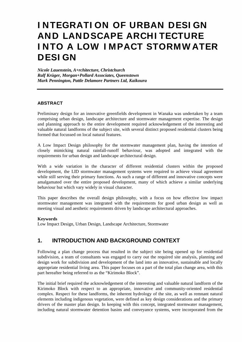
The landscape that will be occupied by residential housing in the future is part of a significantly beautiful wider landscape. Unfortunately already divorced from much of it, this part of Wanaka offers remnant landforms typical of the glaciated and lakes landscape found here.
Maintaining this landscape as underlying and supporting form and providing guiding principles for residential development was what the professional team envisaged at the time of the plan change application. A diverse group of clients - the landowners - and the Queenstown Lakes District Council had taken the advice on board that the approach here could and should be different to the normal setting aside of low density residential land, and when the application was prepared, it was strongly landscape driven.
A thorough landscape assessment process was undertaken, with a catchment analysis an important component of it. The enclosing element - Beacon Point Ridge - and its connection as well as interrelationship with the landform of the Kirimoko Block is of wider significance. This important landscape feature illustrates the extent glaciers advanced during the Pleistocene period. The gently rolling landform with gentle to moderate slopes is located on old terminal moraine at the southern end of Lake Wanaka. It is a contributing element to the complex of interrelated terminal moraine landforms of the Upper Clutha Basin. The wider significance of these landforms is enhanced by the fact that they remain largely intact, they are clearly visible from the surrounding district and they are legible as pre-historic landscape features. These aspects of the site can and should remain visible in any form of development.
This also applies to vegetation - remnant clumps of endemic kanuka shrubland including Coprosma spp, matagouri and Carmichaelia are visually significant and ecologically relevant and can form part of the future residential structure.
Figure 1: Wanaka's Lake - Hills - Grassland Environment
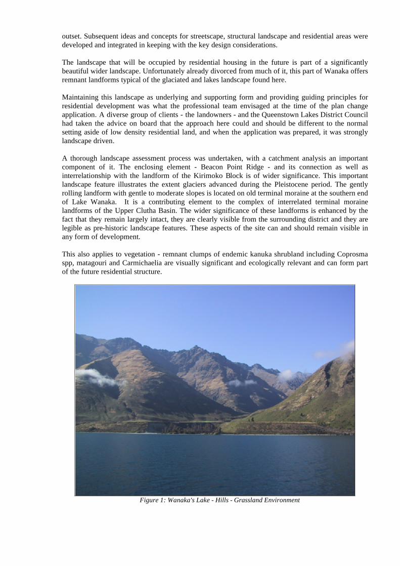
Overall, an intact portion of rural, Upper Clutha landscape presents itself for development. Does it need to be bulldozed to make way for development? The landowner’s vision for the development strongly supported maintenance of these values, and subsequent to the landscape assessment process, conceptual design was initiated. At this stage, it was recognised that a multi-disciplinary approach to subdivision was to be considered at the subdivision design stage. The conceptual design eventually culminated in the much-reduced structure plan shown in Figure 2.
Figure 2: Kirimoko Block Structure Plan
This may appear to look a little strange at first glance. Based on the gained knowledge of the topography, the existing vegetation cover, the hydrology, the solar exposure of the site and other relevant detail, a coarse landuse diagram was prepared. From this diagram – through a number of iterations – this plan evolved. Due to the rudimentary nature of a structure plan, detail cannot be shown, but the base was laid for a landscape-oriented residential development design, incorporating a low-impact stormwater collection, retention and disposal system.
A series of objectives and principles were developed, with the principal and overarching objective being:
Create a liveable and innovative, multiple-use urban environment in accordance with best practices in all forms of development; recognising the local landscape, ecology and living urban fabric.
To achieve the objective, several key principles were defined. Some of these (i.e. those that are relevant to this paper) are as follows:
Landscape and Ecology - Visual Protect and enhance visual amenity from within and outside the subdivision, preserving sightlines and local natural forms.
From external viewpoints, this is achieved primarily via the Open Space Zone. This zone does naturally also play a major role for visibility aspects from within the proposed urban area. Here, shorter, more intimate views are those that are important. This is facilitated by varying widths of the road reserve, recognising landform and slopes and utilising these features for the benefit of maintaining vistas and enhancing user amenity.
Landscape and Ecology - Topography
Protect the site’s unique natural topography as the driver for all settlement activities.
The topography of the Kirimoko Block is strongly undulating and complex. Any attempt to impose “over-engineered” elements – in particular roads – will inevitably lead to excessive earthworks and scars that are difficult to heal in this challenging climate.
These goals can be achieved by sensitively routing roads and their reserves – often coinciding with stormwater flow paths - as well as footpaths and cycle paths through the terrain. Likewise, the design of the allotments, their relationship with roads and landforms must be governed by this principle. Non-sensitive buildings can be prevented by way of subdivision design and rules.
Such principles must propagate upwards from the structure plan and must penetrate the entire process of creating urban form right through to the private individual. Omitting the inclusion of these principles from the outset of creating new urban areas will make the implementation of the objectives and principles more difficult at all later stages of development.
Landscape and Ecology - Remnants and Landscape Planting Avoid disturbance of existing native plant remnants and enhance these by adding and linking. Steep gullies and seepages offer opportunity to extend the existing ecological pattern.
Recognise road reserves as supportive extensions of the green network.
A number of native vegetation remnants are present on the Kirimoko Block. These are significant, as they represent the original vegetation cover and can provide structure to the urban fabric. They can also assist in giving clues as to the alignment of the open space network. All such remnants contain primarily Kanuka and some other grey shrubland species such as Coprosma and Carmichaelia, to name a few.
Hydrology Encourage slowing of stormwater surface runoff and utilize for the protection and enhancement of remnant and planted areas.
Avoid fast discharge to engineered stormwater devices.
This aspect is focussed on in more detail later in this paper. The roads, footpaths and carparking areas themselves can foster stormwater infiltration, slowdown of runoff and retention of water.
Living EnvironmentRecognise that socially cohesive sustainable urban communities require physical connections and public spaces.
Walkways and green links will facilitate social interaction, linking Kirimoko neighbourhoods both internally and with neighbouring urban areas.
Social spaces shall cater for the whole community; a varied landscape, with a focus on accessibility, safety, security.
All possible opportunities to connect the various components of the proposed open space network must be utilised. A multitude of footpaths, linking the Open Space Zone, possible reserve areas, asmall neighbourhood park and other useable areas within the new urban area will create a lively and cohesive environment.
Road Reserves
Roading corridors shall be multi-use spaces, with ecological, hydrological, vehicular and amenity functions at levels appropriate to the corridor hierarchy (NZS 4404:1981 301.2.1.1 a.)
Roads will follow contours and be located on flatter, gentler slopes. All cut and fill areas shall be in keeping with the lie of the land, following contours. Any grades on cut and fill will reflect existing natural topography.
On the steepest slopes lanes and footpaths will be separated to reduce earthworks, enabling gentler batter.
Variable road reserve widths shall be used for landscape benefits (NZS 4404:1981 301.9.2 b para. 5 and 301.4.2.2.)
Berms shall provide for multiple uses:- Stormwater management
- Amenity - Recreation - Ecology
Runoff from roads shall be absorbed, filtered and cleaned within the reserve network (refer Fig. 1 (NZS 4404:1981 301.8.1.))
It is envisaged that roads in the proposed Kirimoko area will play multifunctional roles. It is the landscape architect’s opinion - and professional experience from having lived and worked in Central Europe - that the days of the sole function of roads as conveyors of vehicular traffic are gone. In particular, this applies most specifically to those roads that are ranked low on the traffic-count scale.
NZ Standard 4404:1981 and the Standards NZ handbook 44 “Subdivision for People and the Environment” (SNZ HB 44) recognise this and enable road designs that allow other functions to be included or even dominate.
Engineering Engineering and infrastructure shall be subordinate to and supportive of above principles.
This is an important principle which is supported and strengthened by the SNZ HB44 “Subdivision for People and the Environment”. For those not having used this document, please have a good read! In fact, some local authorities – the Queenstown Lakes District Council amongst them - have adopted this handbook as part of the engineering standards.
Having done all that work the team of consultants was happy to learn that the plan change was approved in the end.
2. LANDSCAPE AND WATER
The shaping of the landscape is very strongly associated with the erosional forces of water. Most of the earth’s landscapes have at some stage been inundated with water, ice or both. Some still are and all show signs of the water’s work. Landscape and stormwater have another very close association.To assess the landscape it is broken break it into landscape units and these are often the same as catchments. The way water has shaped a particular area often reflects in the way we see the landscape.
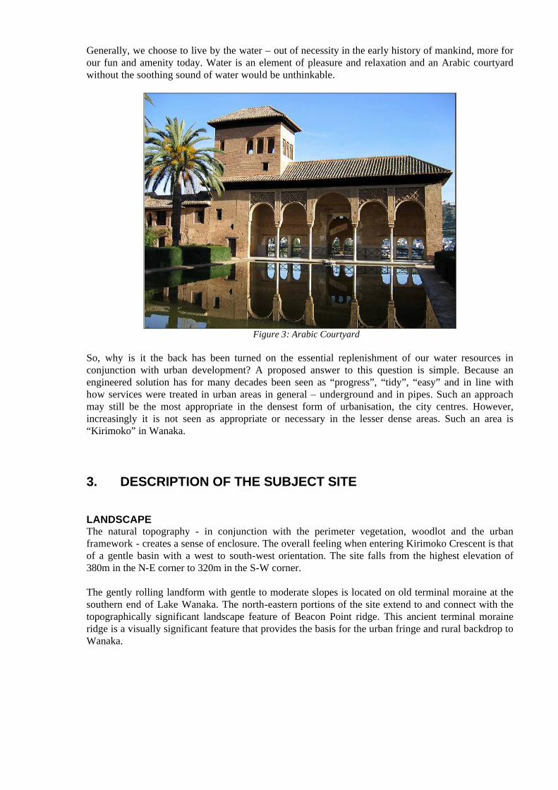
Generally, we choose to live by the water – out of necessity in the early history of mankind, more for our fun and amenity today. Water is an element of pleasure and relaxation and an Arabic courtyard without the soothing sound of water would be unthinkable.
Figure 3: Arabic Courtyard
So, why is it the back has been turned on the essential replenishment of our water resources in conjunction with urban development? A proposed answer to this question is simple. Because an engineered solution has for many decades been seen as “progress”, “tidy”, “easy” and in line with how services were treated in urban areas in general – underground and in pipes. Such an approach may still be the most appropriate in the densest form of urbanisation, the city centres. However, increasingly it is not seen as appropriate or necessary in the lesser dense areas. Such an area is “Kirimoko” in Wanaka.
3. DESCRIPTION OF THE SUBJECT SITE
LANDSCAPEThe natural topography - in conjunction with the perimeter vegetation, woodlot and the urban framework - creates a sense of enclosure. The overall feeling when entering Kirimoko Crescent is that of a gentle basin with a west to south-west orientation. The site falls from the highest elevation of 380m in the N-E corner to 320m in the S-W corner.
The gently rolling landform with gentle to moderate slopes is located on old terminal moraine at the southern end of Lake Wanaka. The north-eastern portions of the site extend to and connect with the topographically significant landscape feature of Beacon Point ridge. This ancient terminal moraine ridge is a visually significant feature that provides the basis for the urban fringe and rural backdrop to Wanaka.
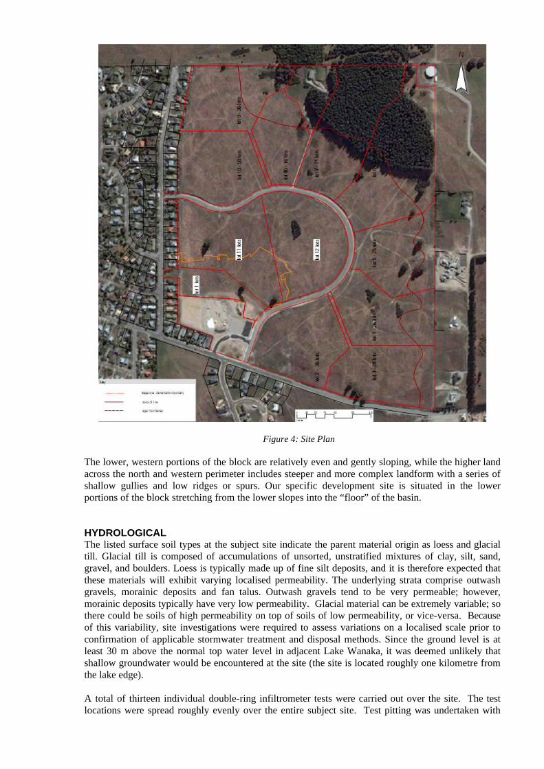
Figure 4: Site Plan
The lower, western portions of the block are relatively even and gently sloping, while the higher land across the north and western perimeter includes steeper and more complex landform with a series of shallow gullies and low ridges or spurs. Our specific development site is situated in the lower portions of the block stretching from the lower slopes into the “floor” of the basin.
HYDROLOGICALThe listed surface soil types at the subject site indicate the parent material origin as loess and glacial till. Glacial till is composed of accumulations of unsorted, unstratified mixtures of clay, silt, sand, gravel, and boulders. Loess is typically made up of fine silt deposits, and it is therefore expected that these materials will exhibit varying localised permeability. The underlying strata comprise outwash gravels, morainic deposits and fan talus. Outwash gravels tend to be very permeable; however, morainic deposits typically have very low permeability. Glacial material can be extremely variable; so there could be soils of high permeability on top of soils of low permeability, or vice-versa. Because of this variability, site investigations were required to assess variations on a localised scale prior to confirmation of applicable stormwater treatment and disposal methods. Since the ground level is at least 30 m above the normal top water level in adjacent Lake Wanaka, it was deemed unlikely that shallow groundwater would be encountered at the site (the site is located roughly one kilometre from the lake edge).
A total of thirteen individual double-ring infiltrometer tests were carried out over the site. The test locations were spread roughly evenly over the entire subject site. Test pitting was undertaken with

individual soakage tests being carried out at six separate locations spread over the proposed development area. The 2m x 2m square test pits were excavated to approximately 500 mm below the ground surface - roughly just beneath the topsoil layer.
Data recorded during the this field testing programme were then used to carry out detailed analysis on existing surface vertical infiltration rates, provided by the double-ring infiltrometer tests, as well as the combined vertical and horizontal infiltration rates of the underlying strata as recorded from the test pits.Two test pits were also dug solely for the purpose of gaining a better understanding of the underlying strata. The underlying strata were noted as having a topsoil layer extending from the surface to a depth of roughly 0.5 metres, underlying the topsoil was a 3 metre thick layer of sandy silts.
Stabilised infiltration rates varied between 12 mm/hr and 70 mm/hr. Despite such a wide variation, the majority of the results appeared to converge around 20 - 25 mm/hr. In addition to these double-ring tests, soakage rates were estimated from constant head tests conducted within test pits. Largely the test pit results were in fairly close agreement with one another. The highest infiltration result was obtained close to one of the main outfall locations from the site – which was pleasing. Having high infiltration rates near the outfall at the downstream end of the stormwater system allows for added redundancy in the system and provides a greater opportunity for soakage to ground.
For the purposes of hydrological analysis the resulting infiltration rate with a driving head of 300 mm was considered to be indicative of the underlying strata for design purposes. This is because designed detention areas would have at least this depth over much of the ponded duration.
URBAN DESIGNThe Kirimoko block is a physically well contained area with good access points, northern exposure and several overarching viewshafts. The gentle sloping ground is ideal for development, with good stability and natural stormwater system.
On the higher slopes the landform provides natural features for buildings to group around and nestle into the landscape. The lower part of the land forms a natural basin where a more intense urban development can take place.
Access to the site is already exists at the lower part of the block via Kirimoko crescent. The road itselffollows an unnatural path creating large cuts. Unfortunately these were formed before the full landscape appreciation process was fully implemented. However, within the crescent the roading design layout should follow natural contours enabling more balanced and fluid forms.
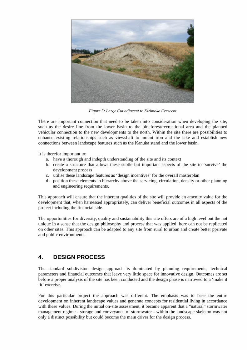
Figure 5: Large Cut adjacent to Kirimoko Crescent
There are important connection that need to be taken into consideration when developing the site, such as the desire line from the lower basin to the pineforest/recreational area and the planned vehicular connection to the new developments to the north. Within the site there are possibilities to enhance existing relationships such as viewshaft to mount iron and the lake and establish new connections between landscape features such as the Kanuka stand and the lower basin.
It is therefor important to:a. have a thorough and indepth understanding of the site and its context b. create a structure that allows these subtle but important aspects of the site to ‘survive’ the
development process c. utilise these landscape features as ‘design incentives’ for the overall masterpland. position these elements in hierarchy above the servicing, circulation, density or other planning
and engineering requirements.
This approach will ensure that the inherent qualities of the site will provide an amenity value for the development that, when harnessed appropriately, can deliver beneficial outcomes in all aspects of the project including the financial side.
The opportunities for diversity, quality and sustainability this site offers are of a high level but the not unique in a sense that the design philosophy and process that was applied here can not be replicated on other sites. This approach can be adapted to any site from rural to urban and create better pprivate and public environments.
4. DESIGN PROCESS
The standard subdivision design approach is dominated by planning requirements, technical parameters and financial outcomes that leave very little space for innovative design. Outcomes are set before a proper analysis of the site has been conducted and the design phase is narrowed to a ‘make it fit’ exercise.
For this particular project the approach was different. The emphasis was to base the entire development on inherent landscape values and generate concepts for residential living in accordance with these values. During the initial on-site assessment, it became apparent that a “natural” stormwater management regime - storage and conveyance of stormwater - within the landscape skeleton was not only a distinct possibility but could become the main driver for the design process.
This necessitated close co-operation between the urban design team, the landscape team and the stormwater consultant. As an essential part of the process, stormwater specialists were engaged to analyse the stormwater catchment and to design stormwater management systems that were aligned with landscape values and the philosophies underpinning the proposed residential living area.
This close co-operation developed into an “amalgamation” of these teams. The sharing of ideas assisted the design process and facilitated the generation of an integrated and comprehensive subdivision and development proposal.
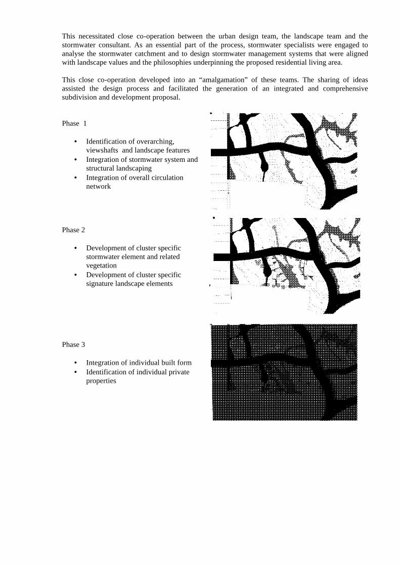
Phase 1
• Identification of overarching, viewshafts and landscape features
• Integration of stormwater system and structural landscaping
• Integration of overall circulation network
Phase 2
• Development of cluster specific stormwater element and related vegetation
• Development of cluster specific signature landscape elements
Phase 3
• Integration of individual built form
• Identification of individual private properties
5. THE PROPOSED DEVELOPMENT
The design brief was essentially for a low to medium density residential development. However, a development process that differs from regular residential subdivision processes was allowed for within the vision of the Client.
The change from rural to urban on the Kirimoko Block offered opportunities in terms of using “alternative” subdivision techniques that should not be missed. Landowner’s/ developer’s returns on their investment will be equally high, if not higher. None of these “techniques” are radical or experimental – they are used all over the world including New Zealand and they are well proven!
As a consequence from the plan change and the documentation manifested in the District Plan, the first group to develop land here recognised and embraced the approach suggested. A multi-disciplinary team was formed – the core of which is here with you today.
Both from an ecological and amenity perspective but also from a visual aspect, it is desirable to allow, encourage and design penetration of the urban fabric with values deriving from the underlying and surrounding natural patterns. Urban development is not necessarily incompatible with retaining natural processes and values if carried out in an innovative, well-designed and sensitive manner. The goals of maintaining ecological functions, improving water quality and creating beautiful, liveable and high value (financial and otherwise) urban spaces are not exclusive of each other but can be achieved mutually and in an integrated way.
Elements used in the greenbelt design can be used in the creation of links, capillaries and small neighbourhood parks/ reserves. In the case of the Kirimoko Block, some beautiful and healthy stands of Kanuka (including other valuable and typical indigenous species) are existing and should be used to achieve landscape penetration.
Creating a blank sheet, a bulldozed pre-structured subdivision is easy. Replanting, nurturing and maintaining new plantings is costly and often not very successful in climates like Wanaka. The use of extensive irrigation is rapidly becoming unsustainable and costly for the local authorities.
Therefore, any existing vegetation is invaluable and must be incorporated wherever possible.
The site offers significant opportunity to set standards in terms of environmentally sensitive architecture, the use of solar energy, water conservation and other future-oriented aspects. It also offers considerable opportunity to set standards in terms of subdivision design and landscape integration.
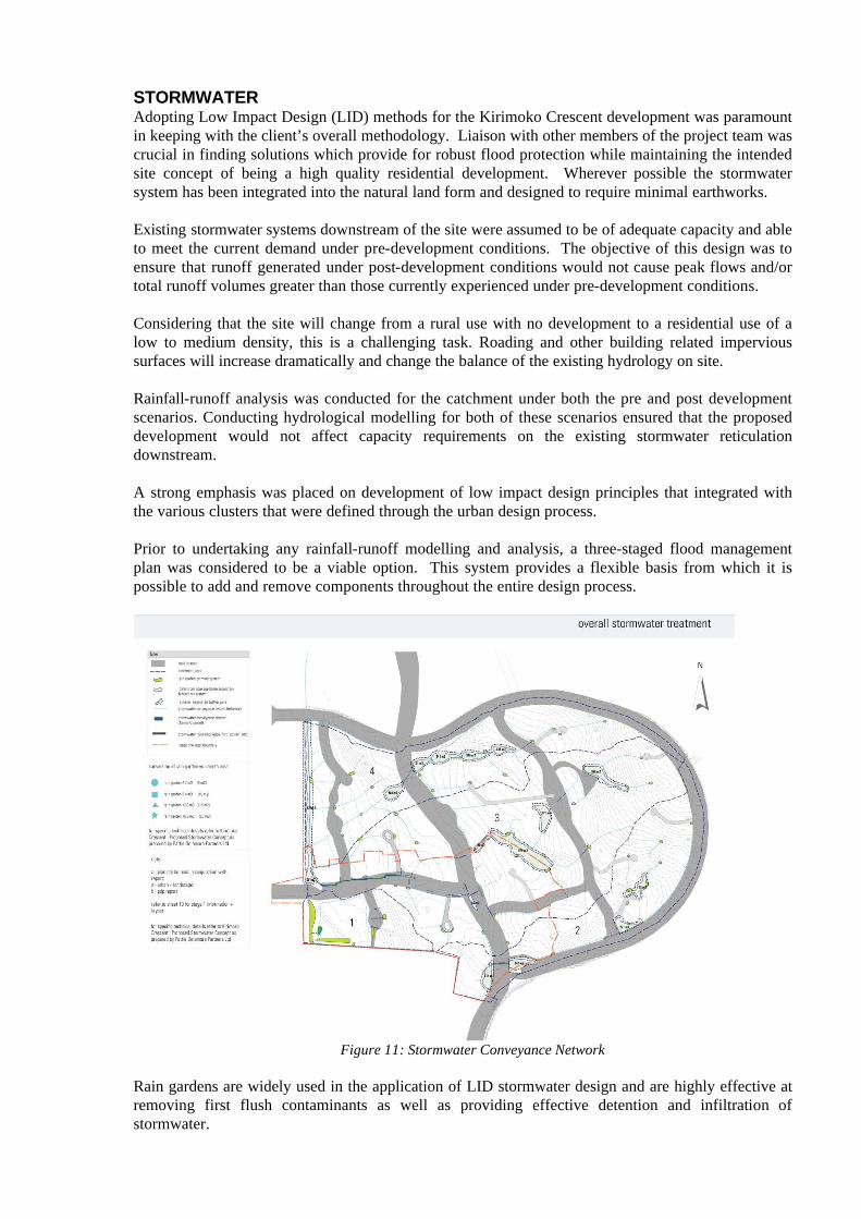
STORMWATERAdopting Low Impact Design (LID) methods for the Kirimoko Crescent development was paramount in keeping with the client’s overall methodology. Liaison with other members of the project team was crucial in finding solutions which provide for robust flood protection while maintaining the intended site concept of being a high quality residential development. Wherever possible the stormwater system has been integrated into the natural land form and designed to require minimal earthworks.
Existing stormwater systems downstream of the site were assumed to be of adequate capacity and able to meet the current demand under pre-development conditions. The objective of this design was to ensure that runoff generated under post-development conditions would not cause peak flows and/or total runoff volumes greater than those currently experienced under pre-development conditions.
Considering that the site will change from a rural use with no development to a residential use of a low to medium density, this is a challenging task. Roading and other building related impervious surfaces will increase dramatically and change the balance of the existing hydrology on site.
Rainfall-runoff analysis was conducted for the catchment under both the pre and post development scenarios. Conducting hydrological modelling for both of these scenarios ensured that the proposed development would not affect capacity requirements on the existing stormwater reticulation downstream.
A strong emphasis was placed on development of low impact design principles that integrated with the various clusters that were defined through the urban design process.
Prior to undertaking any rainfall-runoff modelling and analysis, a three-staged flood management plan was considered to be a viable option. This system provides a flexible basis from which it is possible to add and remove components throughout the entire design process.
Figure 11: Stormwater Conveyance Network
Rain gardens are widely used in the application of LID stormwater design and are highly effective at removing first flush contaminants as well as providing effective detention and infiltration of stormwater.
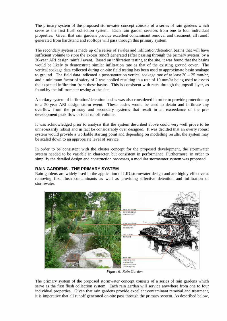
The primary system of the proposed stormwater concept consists of a series of rain gardens which serve as the first flush collection system. Each rain garden services from one to four individual properties. Given that rain gardens provide excellent contaminant removal and treatment, all runoff generated from hardstand and rooftops will pass through this primary system.
The secondary system is made up of a series of swales and infiltration/detention basins that will have sufficient volume to store the excess runoff generated (after passing through the primary system) by a 20-year ARI design rainfall event. Based on infiltration testing at the site, it was found that the basins would be likely to demonstrate similar infiltration rate as that of the existing ground cover. The vertical soakage data collected during on-site field testing has been used to approximate basin soakage to ground. The field data indicated a post-saturation vertical soakage rate of at least 20 – 25 mm/hr, and a minimum factor of safety of 2 was applied resulting in a rate of 10 mm/hr being used to assess the expected infiltration from these basins. This is consistent with rates through the topsoil layer, as found by the infiltrometer testing at the site.
A tertiary system of infiltration/detention basins was also considered in order to provide protection up to a 50-year ARI design storm event. These basins would be used to detain and infiltrate any overflow from the primary and secondary systems that result in an exceedance of the pre-development peak flow or total runoff volume.
It was acknowledged prior to analysis that the system described above could very well prove to be unnecessarily robust and in fact be considerably over designed. It was decided that an overly robust system would provide a workable starting point and depending on modelling results, the system may be scaled down to an appropriate level of service.
In order to be consistent with the cluster concept for the proposed development, the stormwater system needed to be variable in character, but consistent in performance. Furthermore, in order to simplify the detailed design and construction processes, a modular stormwater system was proposed.
RAIN GARDENS - THE PRIMARY SYSTEMRain gardens are widely used in the application of LID stormwater design and are highly effective at removing first flush contaminants as well as providing effective detention and infiltration of stormwater.
Figure 6: Rain Garden
The primary system of the proposed stormwater concept consists of a series of rain gardens which serve as the first flush collection system. Each rain garden will service anywhere from one to four individual properties. Given that rain gardens provide excellent contaminant removal and treatment, it is imperative that all runoff generated on-site pass through the primary system. As described below,

rain gardens have been designed to meet the built form requirements within specific areas within the overall development.
INFILTRATION/DETENTION BASINS – SECONDARY SYSTEMThe secondary system is made up of a series of infiltration/detention basins that will have sufficient volume to temporarily store and then dispose of the excess runoff generated (after passing through the primary system) to ground by a 20-year ARI design storm event. These secondary basins are located throughout the site where natural gullys and larger indentations occur.
TERTIARY SYSTEMA tertiary system of infiltration/detention basins was also considered to provide protection in events of ARI up to 50 years (a “50-year event”). These basins were sized to detain and infiltrate any overflow from the primary and secondary systems that result in an exceedance of the pre-development peak flow or total runoff volume. These ‘final’ basins are located at the lowest part of the site alongside the road reserve for easy access.
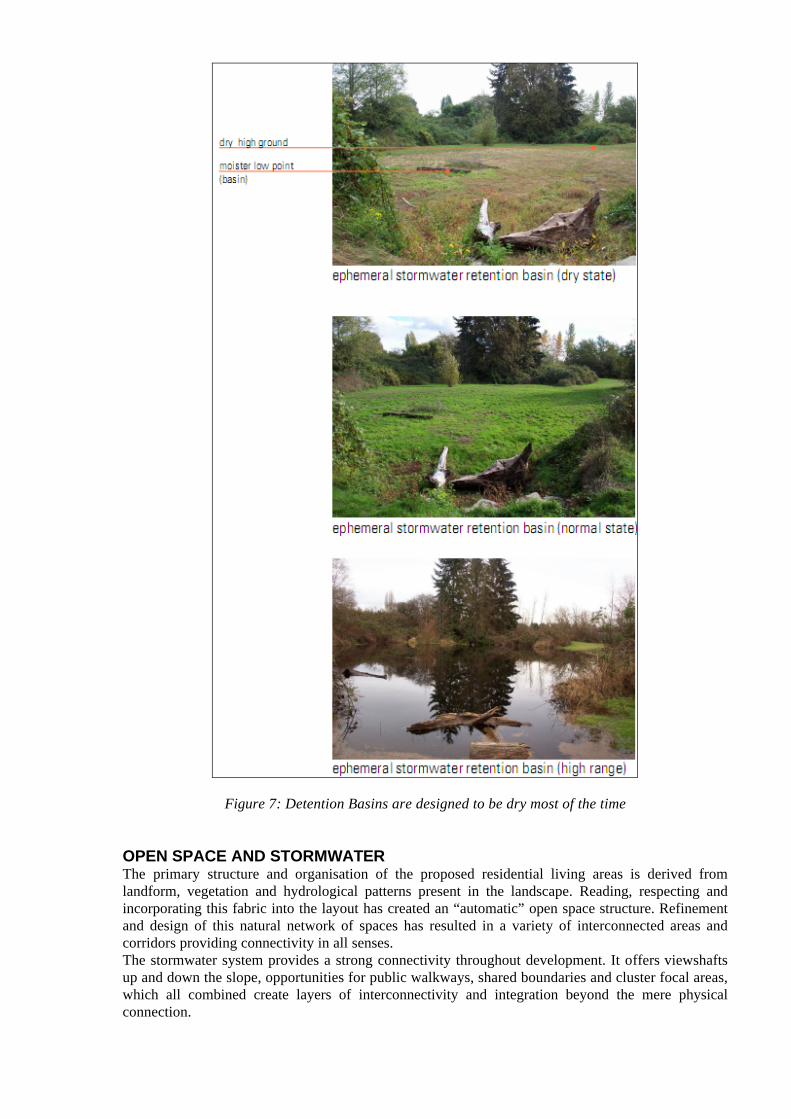
Figure 7: Detention Basins are designed to be dry most of the time
OPEN SPACE AND STORMWATERThe primary structure and organisation of the proposed residential living areas is derived from landform, vegetation and hydrological patterns present in the landscape. Reading, respecting and incorporating this fabric into the layout has created an “automatic” open space structure. Refinement and design of this natural network of spaces has resulted in a variety of interconnected areas and corridors providing connectivity in all senses. The stormwater system provides a strong connectivity throughout development. It offers viewshafts up and down the slope, opportunities for public walkways, shared boundaries and cluster focal areas, which all combined create layers of interconnectivity and integration beyond the mere physical connection.
Three larger stormwater storage and detention areas contribute to the open space network. They are predominantly dry and only fill in times of significant prolonged rainfall and therefore provide recreational outdoor spaces for the higher density living areas within the lower basin.
Although having its main purpose to enable good vehicular circulation, the road reserve is arguably the most important part of the open space network. At the same time, it forms an integral part of the landscape design and sets a framework for the low impact stormwater system.
Situated within both public and private spaces, rain gardens are the first receptors and they become an integral part of each individual site, assisting the overall water management whilst improving the microclimate of each individual lot.
The infiltration/detention basins and swale conveyance systems as well as the raingardens all provide valuable green space and amenity to the proposed development. The nature of the stormwater design is such that the primary detention and treatment system (raingardens) will provide adequate protection for the majority of rainfall events, leaving the basins and swales dry most of the time. With this in mind, the stormwater concept for the proposed development has been developed to co-locate stormwater works with planned green space.
The individual gardens are still the main green space contributors covering up to 70% of the developed land and are therefore a major part of the stormwater catchment. Lot sizes and site boundaries have been set to fit into the overall concept using stormwater conveyance and detention to define natural boundaries. These become either a buffer or transition zone between public and private functions or alternatively a shared space that enables neighbourhood communication and interaction across the legal boundaries.
When integrating the circulation network , roads into the low impact stormwater system it wasimportant to reduce impacts on nature and resources by controlling runoff from roads, parking bays and other impervious areas. Reducing the amount of impervious surface area throughout the public and private areas has been a very important factor not only in the design of the public environs but has become an overall design prerogative.
Vegetation is an important element in any urban development, providing relief from hard surfaces and built form, adding variety to the visual scenes, delivering important habitat to sustain the urban ecology and generally adding to people’s enjoyment.
With regard to the stormwater system the vegetation layout and plant selection had to consider the following matters:
• assist water retention, surface shading and more constant transpiration/ evaporation through plant cover
• be sustainable in respect to biophysical conditions and contributing to subdivision engineering requirements
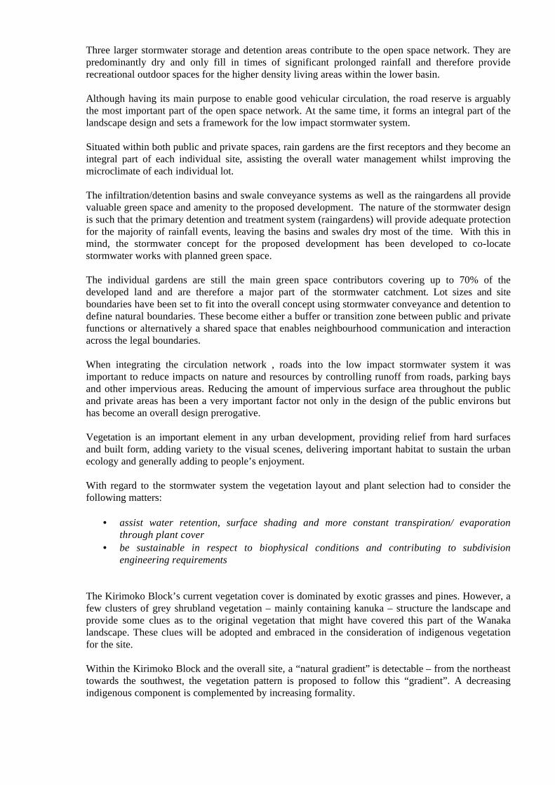
The Kirimoko Block’s current vegetation cover is dominated by exotic grasses and pines. However, a few clusters of grey shrubland vegetation – mainly containing kanuka – structure the landscape and provide some clues as to the original vegetation that might have covered this part of the Wanaka landscape. These clues will be adopted and embraced in the consideration of indigenous vegetation for the site.
Within the Kirimoko Block and the overall site, a “natural gradient” is detectable – from the northeast towards the southwest, the vegetation pattern is proposed to follow this “gradient”. A decreasing indigenous component is complemented by increasing formality.
The stormwater treatment follows this principle changing from predominantly indigenous, informal and “natural” appearance in the higher altitude clusters, to predominantly formal and “designed” structures in the lower altitude clusters.
Although no part of the Kirimoko Block qualifies as “wetland”, some areas will have unique qualities with respect to higher moisture levels because of their special function within the stormwater management system. While these ephemeral areas will not be permanently wet they will require a particular type of planting that is tolerant to temporary inundation as well as being able to survive prolonged periods of low moisture levels.
Figure 8: Green Network Plan
BUILT FORM AND STORMWATER
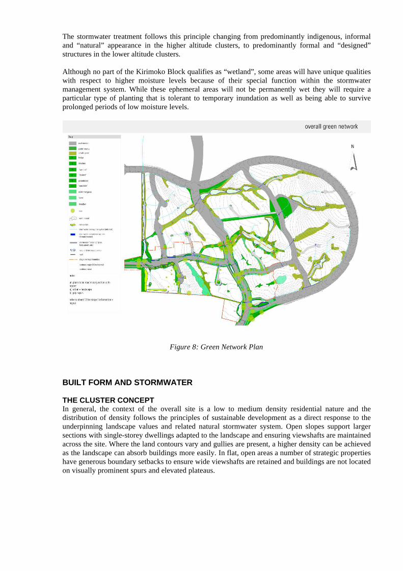
THE CLUSTER CONCEPTIn general, the context of the overall site is a low to medium density residential nature and the distribution of density follows the principles of sustainable development as a direct response to the underpinning landscape values and related natural stormwater system. Open slopes support larger sections with single-storey dwellings adapted to the landscape and ensuring viewshafts are maintained across the site. Where the land contours vary and gullies are present, a higher density can be achieved as the landscape can absorb buildings more easily. In flat, open areas a number of strategic properties have generous boundary setbacks to ensure wide viewshafts are retained and buildings are not located on visually prominent spurs and elevated plateaus.
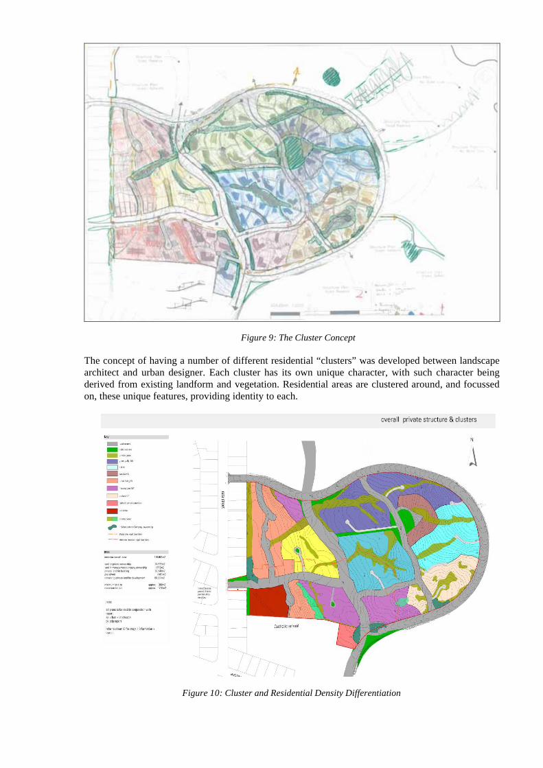
Figure 9: The Cluster Concept
The concept of having a number of different residential “clusters” was developed between landscape architect and urban designer. Each cluster has its own unique character, with such character being derived from existing landform and vegetation. Residential areas are clustered around, and focussed on, these unique features, providing identity to each.
Figure 10: Cluster and Residential Density Differentiation
More dense clusters with careful selection and positioning of buildings are proposed within the core of the Kirimoko basin and around the established Kanuka stand. Within these ‘higher density’/intensified areas the public streets and secondary and tertiary detention areas provide open space for community interaction while contributing to the amenity and quality of each individual property.
The presence of these smaller and larger open/green spaces on public and private land creates adiverse environment that will influence the building typology, their bulk, location and orientation in a positive manner as individual houses are encouraged to engage with these amenities.
Site specific setbacks and height restrictions over and above the district rules have been created for the comprehensive developments within the intensified areas and for the majority of sections to ensure protection of the streetscape and the stormwater system. Additional design guidelines have been created for the entire residential area with cluster specific references to ensure the high standard of urban and landscape design is carried through into the building typology, the actual built form and architectural detail.
STORMWATER INTEGRATION
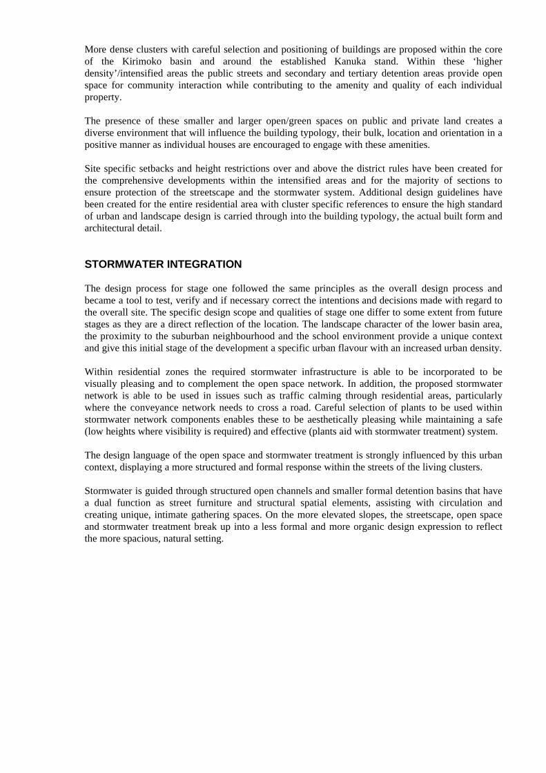
The design process for stage one followed the same principles as the overall design process and became a tool to test, verify and if necessary correct the intentions and decisions made with regard to the overall site. The specific design scope and qualities of stage one differ to some extent from future stages as they are a direct reflection of the location. The landscape character of the lower basin area, the proximity to the suburban neighbourhood and the school environment provide a unique context and give this initial stage of the development a specific urban flavour with an increased urban density.
Within residential zones the required stormwater infrastructure is able to be incorporated to be visually pleasing and to complement the open space network. In addition, the proposed stormwater network is able to be used in issues such as traffic calming through residential areas, particularly where the conveyance network needs to cross a road. Careful selection of plants to be used within stormwater network components enables these to be aesthetically pleasing while maintaining a safe (low heights where visibility is required) and effective (plants aid with stormwater treatment) system.
The design language of the open space and stormwater treatment is strongly influenced by this urban context, displaying a more structured and formal response within the streets of the living clusters.
Stormwater is guided through structured open channels and smaller formal detention basins that have a dual function as street furniture and structural spatial elements, assisting with circulation and creating unique, intimate gathering spaces. On the more elevated slopes, the streetscape, open space and stormwater treatment break up into a less formal and more organic design expression to reflect the more spacious, natural setting.
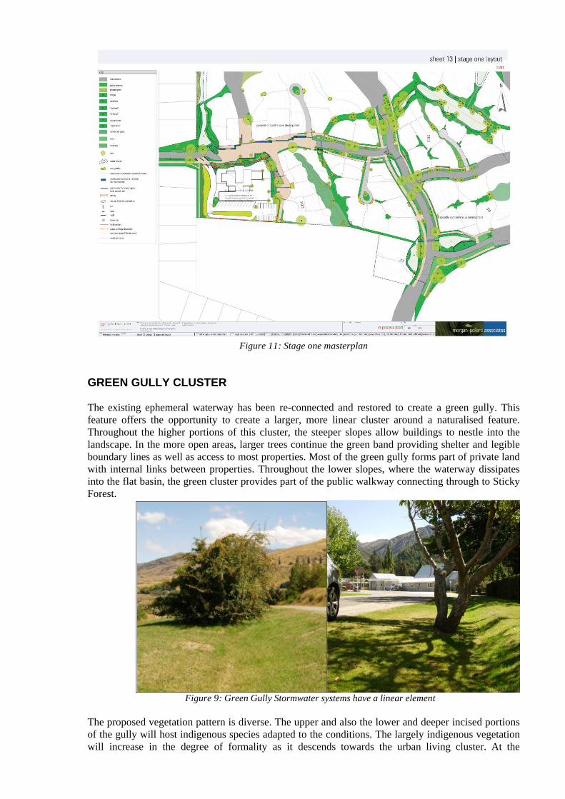
Figure 11: Stage one masterplan
GREEN GULLY CLUSTER
The existing ephemeral waterway has been re-connected and restored to create a green gully. This feature offers the opportunity to create a larger, more linear cluster around a naturalised feature. Throughout the higher portions of this cluster, the steeper slopes allow buildings to nestle into the landscape. In the more open areas, larger trees continue the green band providing shelter and legible boundary lines as well as access to most properties. Most of the green gully forms part of private land with internal links between properties. Throughout the lower slopes, where the waterway dissipates into the flat basin, the green cluster provides part of the public walkway connecting through to Sticky Forest.
Figure 9: Green Gully Stormwater systems have a linear element
The proposed vegetation pattern is diverse. The upper and also the lower and deeper incised portions of the gully will host indigenous species adapted to the conditions. The largely indigenous vegetation will increase in the degree of formality as it descends towards the urban living cluster. At the
intersections with roads, lanes and paths, large canopy trees continue the gully in an elevated third dimension, marking important connections and maintaining continuity. The proposed vegetation pattern will exhibit an increasing degree of formality and ‘exoticness’ towards the urban living cluster.
For the stormwater system servicing this cluster, individual rain gardens form the primary treatment device and receive the initial part of all rainfall events and, for smaller events, all of the runoff from the contributing catchment. Where possible given underlying ground conditions, the outlet from these rain gardens is vertically to soakage. Once these rain gardens have reached capacity during a storm event, excess overflow is directed to the secondary system of swales and infiltration/detention basins. As this cluster focuses on the “green gully, this secondary stormwater system is essentially a linear feature, as indicated in Figure 9. One central grassed and planted swale runs the length of the “green gully”, and within this there are several small check dams to force ponding and infiltration. These check dams also serve as footpath access for crossing over the greengully.
When runoff volume exceeds that able to be detained and infiltrated to ground within this system, a linear swale connects to a downstream infiltration/detention basin. In this cluster the focus for the stormwater system was in creation of a linear feature, about which the development would focus. Planting assists with privacy and stability in steep areas.
KANUKA CLUSTER
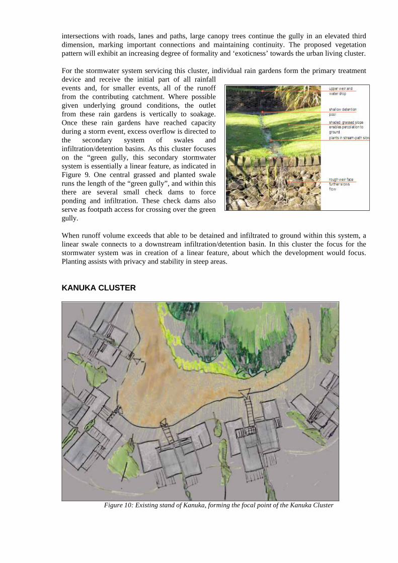
Figure 10: Existing stand of Kanuka, forming the focal point of the Kanuka Cluster
The existing stand of kanuka provides an ideal feature for a small development cluster. A narrow lane hugs the edge of the vegetation, giving access to an intimate and sheltered space framed by terraced houses set into the hill side and a secondary stormwater basin at the end of the small gully. A unique sense of place and community can be achieved via an increase in density to match the scale and proportion of the immediate landscape. On the upper floors glimpses of the distant mountain range and the lake can be obtained. Balconies reach into the communal space to enhance safety and communication within the cluster. Overall the kanuka cluster lends itself to smaller sections with apartment style living and shared garaging some affordable housing could also be integrated into the mix.
In this cluster the focus is on the stand of kanuka. The stormwater system was engineered to complement this by ensuring that this feature remains unchanged and is able to be used by the system in a beneficial manner. A small gully exists immediately upstream of the stand of kanuka which will receive excess runoff from rain gardens located adjacent to individual properties. The secondary system comprises two check dams within this gully, with a wide and level overflow crest that will allow sheet-flow spillage of excess stormwater to the upstream side of the stand of kanuka. Sheet flow through this kanuka stand will then be collected at the downstream edge, from where it is conveyed to a tertiary system via a swale. The emphasis here is in using runoff to provide water to the kanuka stand while allowing for losses within this to occur to reduce the volume that requires conveyance to a disposal point located elsewhere.
WETLAND CLUSTER
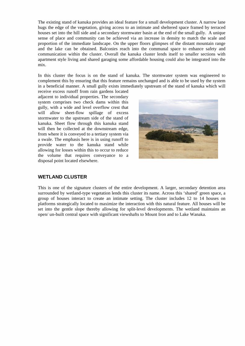
This is one of the signature clusters of the entire development. A larger, secondary detention area surrounded by wetland-type vegetation lends this cluster its name. Across this ‘shared’ green space, a group of houses interact to create an intimate setting. The cluster includes 12 to 14 houses on platforms strategically located to maximize the interaction with this natural feature. All houses will be set into the gentle slope thereby allowing for split-level developments. The wetland maintains an open/ un-built central space with significant viewshafts to Mount Iron and to Lake Wanaka.
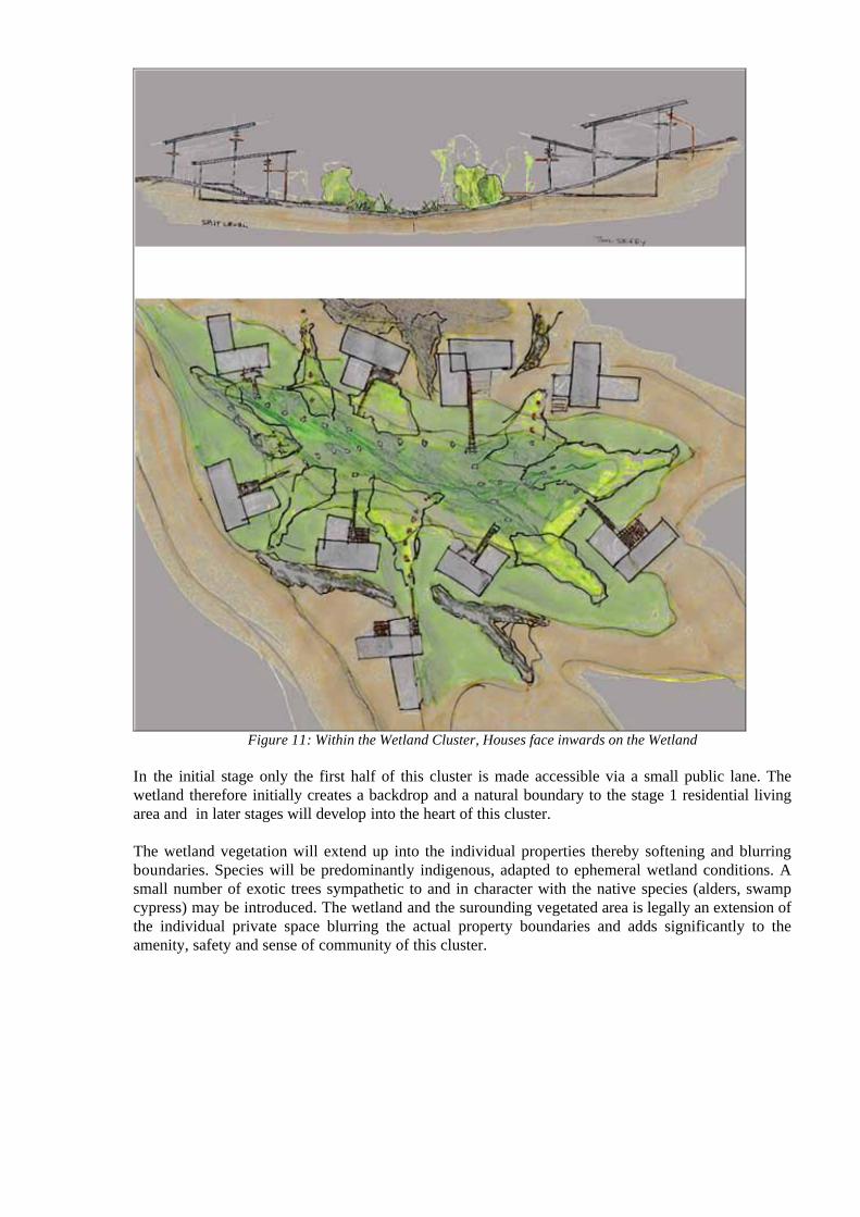
Figure 11: Within the Wetland Cluster, Houses face inwards on the Wetland
In the initial stage only the first half of this cluster is made accessible via a small public lane. The wetland therefore initially creates a backdrop and a natural boundary to the stage 1 residential living area and in later stages will develop into the heart of this cluster.
The wetland vegetation will extend up into the individual properties thereby softening and blurring boundaries. Species will be predominantly indigenous, adapted to ephemeral wetland conditions. A small number of exotic trees sympathetic to and in character with the native species (alders, swamp cypress) may be introduced. The wetland and the surounding vegetated area is legally an extension of the individual private space blurring the actual property boundaries and adds significantly to the amenity, safety and sense of community of this cluster.
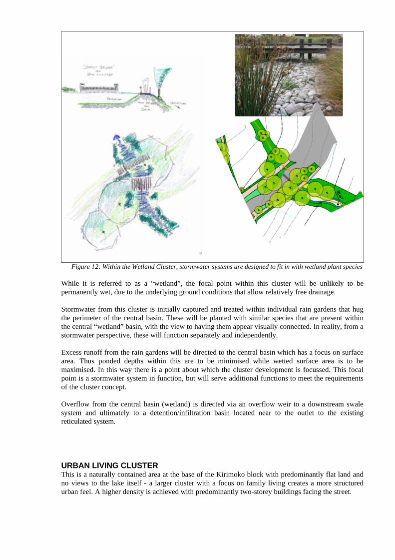
Figure 12: Within the Wetland Cluster, stormwater systems are designed to fit in with wetland plant species
While it is referred to as a “wetland”, the focal point within this cluster will be unlikely to be permanently wet, due to the underlying ground conditions that allow relatively free drainage.
Stormwater from this cluster is initially captured and treated within individual rain gardens that hug the perimeter of the central basin. These will be planted with similar species that are present within the central “wetland” basin, with the view to having them appear visually connected. In reality, from a stormwater perspective, these will function separately and independently.
Excess runoff from the rain gardens will be directed to the central basin which has a focus on surface area. Thus ponded depths within this are to be minimised while wetted surface area is to be maximised. In this way there is a point about which the cluster development is focussed. This focal point is a stormwater system in function, but will serve additional functions to meet the requirements of the cluster concept.
Overflow from the central basin (wetland) is directed via an overflow weir to a downstream swale system and ultimately to a detention/infiltration basin located near to the outlet to the existing reticulated system.
URBAN LIVING CLUSTERThis is a naturally contained area at the base of the Kirimoko block with predominantly flat land and no views to the lake itself - a larger cluster with a focus on family living creates a more structured urban feel. A higher density is achieved with predominantly two-storey buildings facing the street.
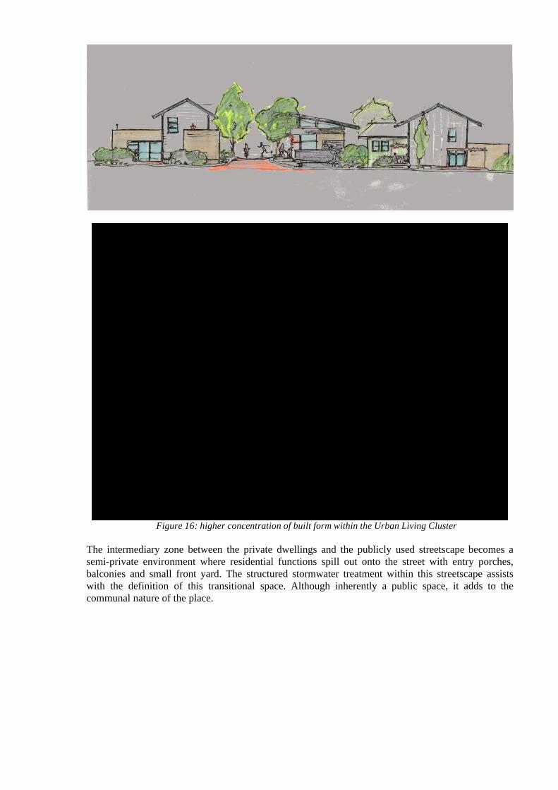
Figure 16: higher concentration of built form within the Urban Living Cluster
The intermediary zone between the private dwellings and the publicly used streetscape becomes a semi-private environment where residential functions spill out onto the street with entry porches, balconies and small front yard. The structured stormwater treatment within this streetscape assists with the definition of this transitional space. Although inherently a public space, it adds to the communal nature of the place.
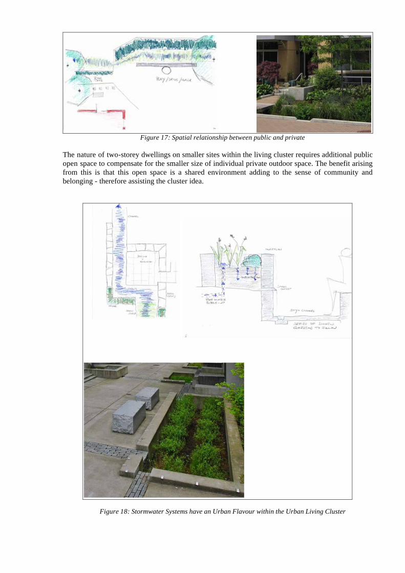
Figure 17: Spatial relationship between public and private
The nature of two-storey dwellings on smaller sites within the living cluster requires additional public open space to compensate for the smaller size of individual private outdoor space. The benefit arising from this is that this open space is a shared environment adding to the sense of community and belonging - therefore assisting the cluster idea.
Figure 18: Stormwater Systems have an Urban Flavour within the Urban Living Cluster
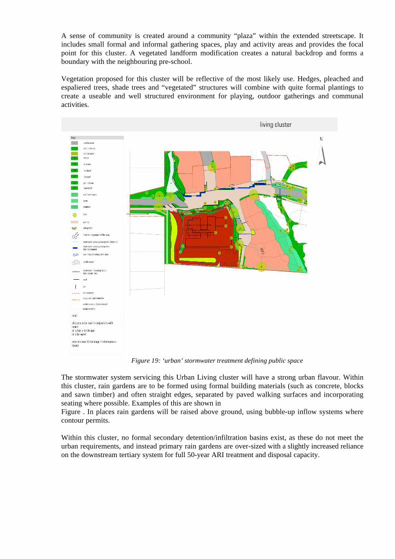
A sense of community is created around a community “plaza” within the extended streetscape. It includes small formal and informal gathering spaces, play and activity areas and provides the focal point for this cluster. A vegetated landform modification creates a natural backdrop and forms a boundary with the neighbouring pre-school.
Vegetation proposed for this cluster will be reflective of the most likely use. Hedges, pleached and espaliered trees, shade trees and “vegetated” structures will combine with quite formal plantings to create a useable and well structured environment for playing, outdoor gatherings and communal activities.
Figure 19: ‘urban’ stormwater treatment defining public space
The stormwater system servicing this Urban Living cluster will have a strong urban flavour. Within this cluster, rain gardens are to be formed using formal building materials (such as concrete, blocks and sawn timber) and often straight edges, separated by paved walking surfaces and incorporating seating where possible. Examples of this are shown in Figure . In places rain gardens will be raised above ground, using bubble-up inflow systems where contour permits.
Within this cluster, no formal secondary detention/infiltration basins exist, as these do not meet the urban requirements, and instead primary rain gardens are over-sized with a slightly increased reliance on the downstream tertiary system for full 50-year ARI treatment and disposal capacity.
6. MAINTENANCE AND CONTROL
Responsibilities for maintenance of stormwater systems depend on ownership of these. Those that are in public ownership are to be managed by local authority, whilst those in private ownership should be managed either by private individuals or by a body corporate type of structure.
Typical failings of rain gardens include lack of weeding (which results in largely aesthetic effects), sediment accumulation around inlets which can cause blockage and result in under-performance, and sediment accumulation within rain gardens themselves which can result in decreased infiltration capacity.
Another design principle is that rain gardens may need to be fully rehabilitated once the construction phase has been completed. Since by far the greatest sediment runoff from a site generally occurs during the construction phase, the completion of this should mark the starting point at which time the rain garden should be fully functional. It is anticipated that prior to any rain gardens proposed for public ownership being handed over to QLDC, any rehabilitation or maintenance that is required would be fully carried out.
For the other elements of the proposed stormwater system, maintenance generally would involve weeding, watering, mowing and removal of accumulated debris and litter. Grassed areas would require mowing to keep grass tidy, and over-mowing during dry periods should be avoided to keep grass alive. Any dead planting within the stormwater system should be replaced.
The responsibilities for maintenance of the system would generally rest with the owner of the system. Thus for publicly owned elements the responsibility for maintenance would be expected to rest with QLDC, while for privately owned elements maintenance would be carried out by the body nominated to manage the private system.
7. CONCLUSION
For the subject site both landscape architect and urban designer were employed to develop the overall concept to integrate fully with the surrounding environment. Stormwater expertise was sourced once these initial concepts had been put forward, and together the team progressed the detail to the point at which subdivision applications could be lodged.
A significant benefit was achieved in this way, in that through the design process competing demands between the three fields of expertise were identified and debated, with alternatives put forward, until a unified development concept could be finalised. Compromises had to be made, but the intention was that all such compromises were balanced through the development. Where urban design had to give way to stormwater in one area, the converse might have been able to apply in another so that an overall development plan that holistically could meet all objectives was arrived upon.
8. REFERENCES
Ministry for the Environment (2008). Climate Change Effects and Impacts Assessment: A Guidance Manual for Local Government in New Zealand. 2nd Edition. Mullan B; Wratt D; Dean S; Hollis M; Allan S; Williams T, Kenny G and MfE. Ministry for the Environment, Wellington. xviii + 149 p.
Department of Building and Housing (2006). Compliance Document for New Zealand Building Code, Clause E1, Surface Water. Wellington.