Embed Size (px)
Citation preview

Integration of Spatial Data inDatabase Acceleration for Analytics
Knut Stolze∗ Josephine Ruckert∗ Frank Butt†
Abstract:The IBM DB2 Analytics Accelerator (IDAA) integrates the strong OLTP capabili-
ties of DB2 for z/OS with very fast processing of OLAP and analytical SQL workloadin Netezza. Today, not all data types supported by DB2 are available for acceleration.One step to narrow this gap is to enable spatial data - in form of polygons, linestrings,and points - for OLAP processing. Since DB2 and Netezza have very different internalarchitectures and different limitations, a straight-forward mapping from the DB2 datatype to Netezza data types is not possible.
We developed a prototype geared toward performance and simplicity for spatialdata support in IDAA. In particular, all SQL statement that work against DB2 shallwork against the accelerator without any changes. In this paper, we describe how theintegration with the accelerator is accomplished so that ingestion and access to thespatial data becomes as seamless and transparent as possible for existing applications.The architecture and implementation aspects for spatial data representation in Netezzaas well as the access during query processing are discussed in detail.
1 Introduction
Data warehouses have evolved from dedicated systems using specialized schemas likestar and snowflake [Leh03] to solutions that strife for a full integration with operationaldata. Limiting the database schema in those ways gives a good theoretical model, but itdoes not always fit well with real (reporting) applications. For instance, the IBM R© datawarehouse industry model for banking and financial markets [IBM12] is neither a star norsnowflake schema, but surely it is intended for data warehousing. Along with such schema-based restrictions came many other requirements and limitations. For example, typicaldata warehouses and OLAP systems support only a subset of data types like integers,floating point numbers, and varchars. However, emerging integrated systems that targetOLTP and OLAP with equally excellent performance cannot allow for such restrictions.Existing applications use data types like large objects (LOBs), XML, or spatial data.
In this paper, we present our works on extending the IBM R© DB2 Analytics Accelerator(IDAA) [BAF+14] to support spatial data. IDAA is a hybrid system, which uses DB2 R© forz/OS R© [IBM14b] for transactional workload. A copy of the data resides in the accelerator,which is based on Netezza technology [Fra11], and deals with analytical workload in a∗IBM Germany Research & Development, Boblingen, Germany†IBM Silicon Valley Lab, San Jose, USA

high performing way. The DB2 optimizer is responsible for the query routing decision,i. e. whether to run the query in DB2 itself or to offload it to the accelerator. For us,this architecture is a stepping stone towards a single operational data store [Inm99]. Thebenefits can be found in an overall reduced complexity of the IT infrastructure and betterintegration, all reducing costs for exploiters.
Many application areas take advantage of storing, retrieval, and querying of geometric,geographic, and spatial data.1 The data space for geographic data is the surface of theEarth, possibly as a two-dimensional abstraction (projection). In geographic contexts, itmodels static objects in the real world like streets, buildings, political boundaries, etc.Moving objects like ships or cars with a changing location can also be described. Otherexamples are disaster control and emergency management requiring information about theexact location of a catastrophe or accident and details about the available infrastructurelike roads and railways. Yet another important user group are military entities, who usespatial data for centuries already for their strategic and tactical planning.
Figure 1: Visualized Map Data Extracted from a DB2 Database System
DB2 for z/OS as well as Netezza already have support for spatial data. Both follow theSQL/MM: Spatial standard [ISO03a, Sto03]. However, there are still differences in thescope of supported functionality and the storage of spatial objects, especially size limi-tations. Those differences must be solved together with processing of spatial queries inIDAA and high performing data ingestion for a fully functional product feature.
In all our efforts, the overriding design principle for providing acceleration capabilities ofspatial data was to avoid changes or requiring rewrites of an application’s SQL statements.A spatial query send to DB2 is rewritten by the DB2 optimizer to the Netezza SQL dialectand then passed on to IDAA, which delegates the actual execution to the Netezza backend.The data structures in Netezza are designed in a way that is just based on function mapping,but without any further changes to the original SQL statement. That means, DB2 is notresponsible for introducing additional joins, for example.
The remainder of the paper is structured as follows. The architecture of the IBM DB2Analytics Accelerator is summarized in section 2. Section 3 gives a very brief overviewon Netezza spatial and DB2 spatial, highlighting details that are important for the inte-gration with IDAA. Our new approach to deal with space limitations in Netezza and therelated integration of spatial support in IDAA are presented in section 4, together with
1Henceforth, the terms geometry, spatial data, and spatial information are used synonymously.

some preliminary performance measurements based on a prototype implementation cur-rently under way. Finally, the paper concludes in section 5 with a summary and generaloutlook to future direction for the development of this new product feature.
2 Overview on the IBM DB2 Analytics Accelerator
IDAA [BAF+14] is based on the Netezza appliance [Fra11], which is used as backend.It provides the data storage capabilities to manage large amounts of data and to provideexceptional performance for querying that data. IDAA’s functionality is extended overtime to better satisfy customer requirements. [Sto13]
Figure 2 illustrates the high-level architecture of IDAA, also called Data Warehouse Ac-celerator. An additional process (DWA) – that implements the integration layer with DB2for z/OS – runs on the Netezza hardware and operating system. This integration layer isthe entry point for all requests originating either from DB2 or IDAA stored proceduresrunning in DB2. The DRDA protocol [DRD03] is used for the communication betweenboth hardware platforms. Requests to execute queries are passed from DB2 to the Netezzabackend by translating DRDA protocol to CLI/ODBC. Administrative requests, e. g., toprovide a list of accelerated tables, are handled in DWA itself. If necessary, SQL queriesagainst the Netezza backend are executed to collect backend-related meta data and/or sta-tistical information.
DWA
Appl
icat
ions
SQLDB2
IDAAStored Procedures
Nete
zza
DBS
SQL ODBC
DRDA(queries)
DRDA(admin)
System z IDAA
Figure 2: IDAA System Architecture
It is possible to associate multiple accelerators with a single DB2 system in order to estab-lish an environment that supports high availability and disaster recovery. An appropriateworkload balancing is applied by DB2 in case the connected accelerators have differenthardware and workload characteristics. Similarly, a single accelerator can be connected tomultiple DB2 systems, sharing its resources. Another workload balancing layer is appliedon that level.
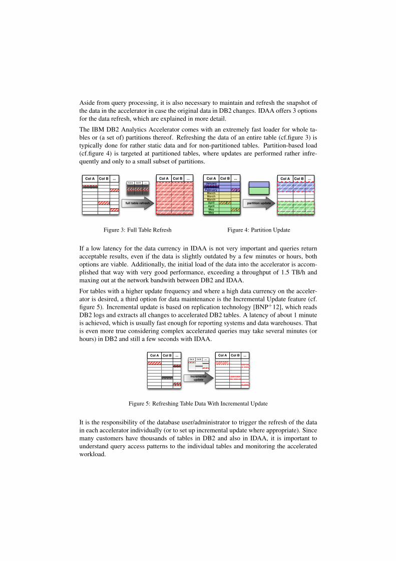
Aside from query processing, it is also necessary to maintain and refresh the snapshot ofthe data in the accelerator in case the original data in DB2 changes. IDAA offers 3 optionsfor the data refresh, which are explained in more detail.
The IBM DB2 Analytics Accelerator comes with an extremely fast loader for whole ta-bles or (a set of) partitions thereof. Refreshing the data of an entire table (cf.figure 3) istypically done for rather static data and for non-partitioned tables. Partition-based load(cf.figure 4) is targeted at partitioned tables, where updates are performed rather infre-quently and only to a small subset of partitions.
...Col BCol A...Col BCol A
full table refresh
...Col BCol A
Figure 3: Full Table Refresh
partition update
...Col BCol A
MayMayAprilAprilMarchMarchMarchFebruaryJanuaryJanuary
...Col BCol A
Figure 4: Partition Update
If a low latency for the data currency in IDAA is not very important and queries returnacceptable results, even if the data is slightly outdated by a few minutes or hours, bothoptions are viable. Additionally, the initial load of the data into the accelerator is accom-plished that way with very good performance, exceeding a throughput of 1.5 TB/h andmaxing out at the network bandwith between DB2 and IDAA.
For tables with a higher update frequency and where a high data currency on the acceler-ator is desired, a third option for data maintenance is the Incremental Update feature (cf.figure 5). Incremental update is based on replication technology [BNP+12], which readsDB2 logs and extracts all changes to accelerated DB2 tables. A latency of about 1 minuteis achieved, which is usually fast enough for reporting systems and data warehouses. Thatis even more true considering complex accelerated queries may take several minutes (orhours) in DB2 and still a few seconds with IDAA.
incremental update
...Col BCol A...Col BCol A...Col BCol A
Figure 5: Refreshing Table Data With Incremental Update
It is the responsibility of the database user/administrator to trigger the refresh of the datain each accelerator individually (or to set up incremental update where appropriate). Sincemany customers have thousands of tables in DB2 and also in IDAA, it is important tounderstand query access patterns to the individual tables and monitoring the acceleratedworkload.

3 Spatial Data
Figure 6: Spatial Primitives
Points, linestrings, and polygons are the basic building blocks for storing spatial data inrelational database systems. The geometries are treated as scalar values with a dedicatedset of functions. Some systems, e. g. DB2 for LUW, employ structured types and establisha hierarchy while others just have a single data type. Other systems use large objects(BLOBs) and encode all details required to represent the geometry in an opaque way. Thisdoes not require complex infrastructure for object-relational extensions. DB2 for z/OS andNetezza have gone that route. [Sto06]
There are over 100 spatial functions, which can loosely be categorized in:
• convert between geometries and external data formats,
• retrieve properties/attributes or measures from a geometry,
• compare two geometries with respect to their spatial relationship, and
• generate new geometries from others.
Probably, the most important category is the comparison based on a spatial relationshipsince those are used for spatial joins. Specific functions exist to test whether 2 geometriesare disjoint, touch each other, overlap, or if one is completely contained in the other.
A few systems have extended their spatial support even further and introduced topologyand network models [Ora05]. Those features will not be further discussed here.
3.1 Spatial Support in DB2 z/OS vs. Netezza
DB2 for z/OS has introduced a built-in data type ST Geometry [IBM14a], which isinternally a derivate of a BLOB. The binary representation holds all information aboutthe specific type (point vs. linestring vs. polygon), the actual coordinates of the pointsdefining the geometry, and additional attributes like the minimum and maximum X and Ycoordinates. The (compressed) binary representation of geometries is limited in size to amaximum of 2 MB. This is sufficient for most practical considerations.
Netezza does not support large objects or structured types. Instead, Netezza’s spatial fea-ture [IBM14c] stores each geometry as a scalar value using VARBINARY underneath. The

maximum size for a scalar value is limited by the 64K page size. The size and precision ofgeometry data can vary considerably. There are geometries that exceed the page size limitvery quickly, e. g. one instance of the border lines of the USA needs 300 K (compressed)alone. In such cases, the too large geometries are split (chopped) into multiple, smaller butconsistent geometries when the data is inserted into the Netezza tables by a separate tool[Sof14]. Naturally, that splitting adds overhead.
Figure 7: Example for Chopping Geometries (Source: [Sof14])
Furthermore, not all spatial functions can be applied correctly to the individual, smallergeometries. An example is shown in figure 8. Assuming that the octogon in figure 8(a) isactually a much more complex geometry, it is broken down into several smaller geometriesas figure 8(b) demonstrates. Attempting to query those multiple geometries may yieldincorrect results as is illustrated using figure 8(c). If the spatial predicate is ST Withinand tests whether the blue query rectangle is fully contained within the (yellow) geometry,the answers on the smaller geometries are all false and there is no way to determine thecorrect answer of true without recomposing the original geometry. Due to these issues,Netezza does not provide all spatial functions.
(a) Original Geometry (b) Multiple Smaller Geometries (c) Sample Query
Figure 8: Functional Problems with Breaking Down Geometries

Our approach below avoids the functional problems for spatial support in IDAA. We takeadvantage of user-defined aggregate functions, table functions, and the presence of IDAAas a layer on top of the Netezza database system, which is running on the same system asNetezza itself. That allows us to properly handle geometries of all sizes when loading datafrom DB2 into IDAA and also when querying the data with any of the spatial predicatessupported by DB2.
4 Integrating Spatial Data in IDAA
The fundamental differences for spatial support in DB2 and Netezza (cf. section 3.1) arereally major obstacles. Breaking down and splitting geometries looses key functionality.Additionally, the overhead for the splitting during ingestion is not acceptable from a per-formance point of view. Therefore, our chosen path is not a light-weight integration of theexisting products but rather a deep integration of spatial functionality in IDAA.
4.1 Storage in Netezza
Our first step resolves the size limitations of Netezza spatial. Naturally, it is still necessaryto break down large geometries in such a way that each part can fit into a single scalarVARBINARY value. But instead of constructing several smaller, consistent geometries,we take the binary representation of the geometry in DB2 and chunk that binary repre-sentation. Figure 9 illustrates this. The individual parts (or chunks) are all equally sized(except the last one), and each chunk fits into a VARBINARY value.
Figure 9: Binary Chunking for Netezza
The first consequence of the chunking is that we can usually not store a geometry togetherwith all its non-spatial attributes (e. g. street name) in one relational table. The chunkedgeometries are stored in an additional side table.2 Denormalization would be an alternate,but not desirable option.
-- user tableCREATE TABLE country (
id INTEGER NOT NULL PRIMARY KEY,
2Side tables are also the means used by Netezza spatial for the same purpose.
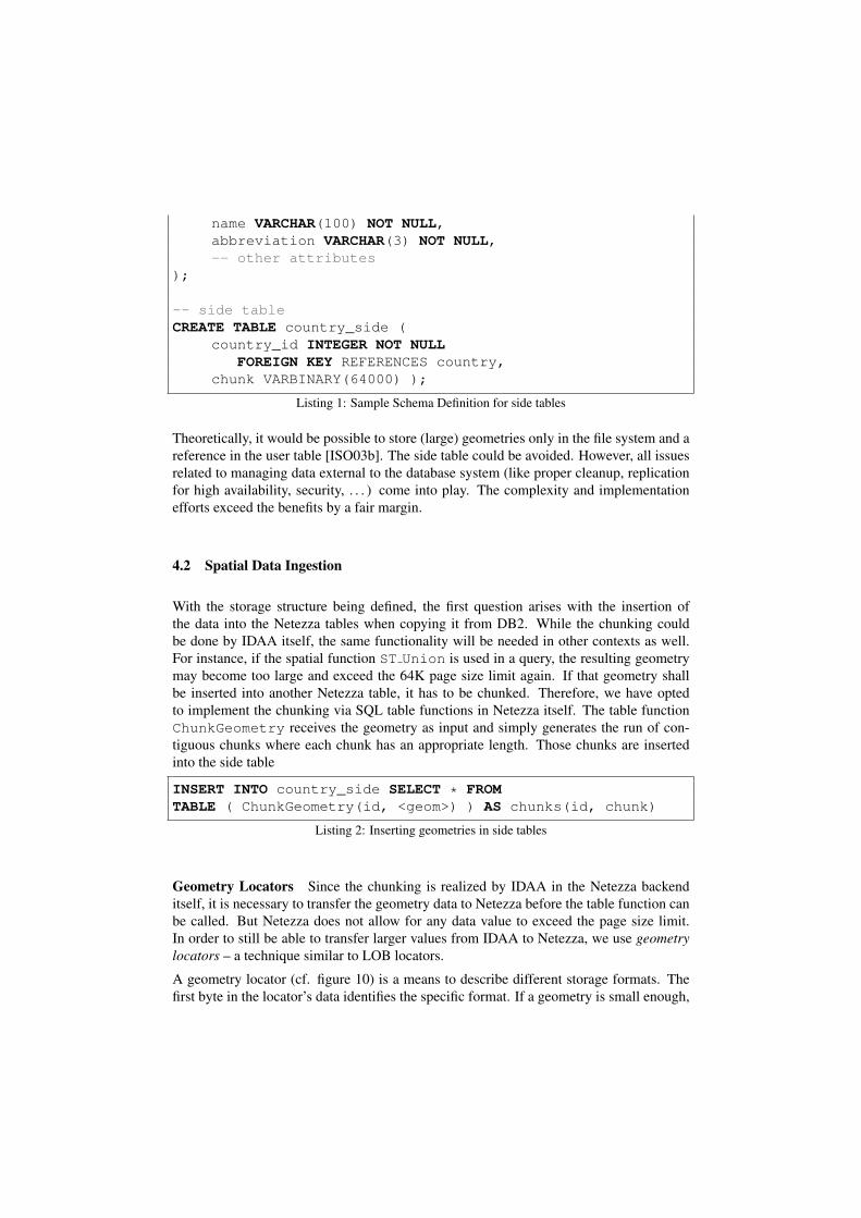
name VARCHAR(100) NOT NULL,abbreviation VARCHAR(3) NOT NULL,-- other attributes
);
-- side tableCREATE TABLE country_side (
country_id INTEGER NOT NULLFOREIGN KEY REFERENCES country,
chunk VARBINARY(64000) );
Listing 1: Sample Schema Definition for side tables
Theoretically, it would be possible to store (large) geometries only in the file system and areference in the user table [ISO03b]. The side table could be avoided. However, all issuesrelated to managing data external to the database system (like proper cleanup, replicationfor high availability, security, . . . ) come into play. The complexity and implementationefforts exceed the benefits by a fair margin.
4.2 Spatial Data Ingestion
With the storage structure being defined, the first question arises with the insertion ofthe data into the Netezza tables when copying it from DB2. While the chunking couldbe done by IDAA itself, the same functionality will be needed in other contexts as well.For instance, if the spatial function ST Union is used in a query, the resulting geometrymay become too large and exceed the 64K page size limit again. If that geometry shallbe inserted into another Netezza table, it has to be chunked. Therefore, we have optedto implement the chunking via SQL table functions in Netezza itself. The table functionChunkGeometry receives the geometry as input and simply generates the run of con-tiguous chunks where each chunk has an appropriate length. Those chunks are insertedinto the side table
INSERT INTO country_side SELECT * FROMTABLE ( ChunkGeometry(id, <geom>) ) AS chunks(id, chunk)
Listing 2: Inserting geometries in side tables
Geometry Locators Since the chunking is realized by IDAA in the Netezza backenditself, it is necessary to transfer the geometry data to Netezza before the table function canbe called. But Netezza does not allow for any data value to exceed the page size limit.In order to still be able to transfer larger values from IDAA to Netezza, we use geometrylocators – a technique similar to LOB locators.
A geometry locator (cf. figure 10) is a means to describe different storage formats. Thefirst byte in the locator’s data identifies the specific format. If a geometry is small enough,

it is directly embedded (inline) and we use an indicator of 0x00. Larger geometries arestored in a file in the file system (or in memory). The file based transfer informs theChunkGeometry function about the file name and the function reads the data from therebased on indicator 0x01.
Figure 10: Geometry Locator
Of course, other options are possible and figure 10 also shows a compressed inline storage.Although, the geometry data is already compressed, it could happen that the binary dataexceeds the page size limit only slightly. Another compression step, e. g. using LZW[Wel84], may reduce the data size just by those few bytes that are needed to squeeze in thegeometry – and, thus, avoid indirections as with the other storage formats.
Note that the (simple) file system based approach works because the IDAA server processruns on the same system as the Netezza backend. Thus, both components have access tothe same file system. If that were not the case, a shared file system or remote file transfercould be used.
Evaluation As of today, we have implemented a prototype of the ChunkGeometryfunction and use it to insert the spatial data from IDAA. The binary chunking beats FME’s[Sof14] chopping into small, consistent geometries. FME needed more than 2 hours for23K geometries (on a very slow system), while our approach finished in 20 minutes. Butnote that we have not conducted any serious performance comparison yet.
4.3 Query and Result Set Processing in IDAA Context
The binary chunking comes with a penalty during query processing: whenever predicatesshall be evaluated on a geometry or other spatial functions are used, it is mandatory torecompose the original geometry. This is accomplished using our new aggregate function

RecomposeGeometry. The aggregate gets all chunks of the geometry as input (asindividual rows from the side table) and internally constructs the full geometry. The resultis a geometry locator.
Recomposition is only needed as the first step in query processing. Once a chunked ge-ometry is recomposed and its geometry locator exists, all stacked spatial functions workwith that locator. Also, the locator is used when binding out the geometry from Netezzato IDAA.
IDAA receives its queries from DB2, and DB2 is not aware of the storage details for spatialdata in the Netezza backend. But we want to avoid complex logic for query rewrite in DB2itself. For each accelerated table with spatial data, we have the above mentioned side table.We use a view to hide this side table and to inject the RecomposeGeometry aggregateat the same time. The view takes the place of the actual accelerated table, so any querysent by DB2 to IDAA is not even aware that a view is accessed. Netezza resolves the viewtransparently into the join over both tables.
CREATE VIEW country_table(id, name, abbreviation, geom) ASSELECT c.id, c.name, c.abbreviation,
RecomposeGeometry(s.chunk)FROM country AS c JOIN country_side AS s
ON ( c.id = s.country_id )GROUP BY c.id;
Listing 3: View to hide side tables and recompose aggregate function
For example, a SQL query in DB2 like SELECT ST Buffer(geom, 5, ’Miles’)FROM country WHERE ... needs to be rewritten to access the specific table nameused in Netezza (country table in our example), and that’s nearly all there is to it.Thus, we have achieved a very simple decoupling of DB2 from the IDAA and Netezzainternal storage mechanism for the spatial data.
We have mentioned above that geometry values are bound out from Netezza to IDAAusing geometry locators. Thus, the result set of the query contains a locator. Given thatresult sets are always consumed by IDAA, IDAA has to resolve the locator and extract thereal geometry either from it directly (if inline) or by accessing the shared file system. Thisis the reverse procedure as for spatial data ingestion into the Netezza backend.
Evaluation Our prototypical implementation has reached the point where we can verifythe functionality. So far, it has proven that we can implement all spatial functions availablein DB2 with the correct semantics. The next steps will be a performance evaluation tomeasure the impact and acceleration for query processing. Due to the additional join withthe side table, we do not expect to achieve the same very good acceleration factors of 10x-100x as IDAA delivers for non-spatial queries. However, our expectations are still suchthat spatial queries scanning over TBs of data should still run very well in our environment.

5 Summary and Outlook
In this paper we have presented a prototype implementation for the integration of spatialdata support into IDAA. The main issue are limitations of the size for VARBINARY valuesin Netezza, which we resolve by chunking the binary representation of large geometriesand storing those chunks in a side table, which is always joined at query time. We haveproven that functional limitations of Netezza spatial can be resolved this way.
Our next steps in this project are more in-depth performance evaluations. We want toexperiment with additional storage formats to exchange large geometries between IDAAand Netezza as well as passing such geometries from one spatial function to the nextwithin the same SQL statement. Although, we always keep the geometry values storedin the Netezza tables, we will evaluate whether caching of recomposed geometries can bedone in order to speed up the recomposition steps. The primary question with such a (filesystem based) cache will become the maintenance, i. e. which geometry objects to cacheand which to discard in order to stay within the available resources like disk space.
6 Trademarks
IBM, DB2, and z/OS are trademarks of International Business Machines Corporation inUSA and/or other countries. Other company, product or service names may be trademarks,or service marks of others. All trademarks are copyright of their respective owners.
References
[BAF+14] P. Bruni, J. Arnold, W. Favero, L. Cruz, J. Feinsmith, A. Griner, J. Guo, C. Harlander,J. Kern, R. Kumar, R. Li, A. Perkins, J. Sloan, S. Speller, and D. Tonelli. Reliability andPerformance with IBM DB2 Analytics Accelerator V4.1. IBM Redbooks, 2014.
[BNP+12] A. Beaton, A. Noor, J. Parkes, B. Shubin, C. Ballard, M. Ketchie, F. Ketelaars, D. Ran-garao, and W.V. Tichelen. Smarter Business: Dynamic Information with IBM InfoSphereData Replication CDC. IBM Redbooks, 2012.
[DRD03] The Open Group. DRDA V5 Vol. 1: Distributed Relational Database Architecture, 2003.
[Fra11] P. Francisco. The Netezza Data Appliance Architecture: A Platform for High Perfor-mance Data Warehousing and Analytics. IBM Redbooks, 2011.
[IBM12] IBM. IBM Banking and Financial Markets Data Warehouse V8.5. Technical report,2012. http://www.ibm.com/software/data/industry-models/financial-markets/.
[IBM14a] IBM. Administering IBM Spatial Support for DB2 for z/OS, 2014.
[IBM14b] IBM. DB2 11 for z/OS, 2014.http://www.ibm.com/support/knowledgecenter/api/content/SSEPEK/db2z prodhome.html.
[IBM14c] IBM. IBM Netezza Analytics – In-Database Analytics Developer’s Guide, Release 3.0.1,2014.

[Inm99] W. Inmon. Building the Operational Data Store. John Wiley & Sons, 1999.
[ISO03a] ISO/IEC 13249-3:2003. Information Technology – Database Languages – SQL Multi-media and Application Packages – Part 3: Spatial, 2nd edition, 2003.
[ISO03b] ISO/IEC 9075-9:2003. Information Technology – Database Languages – SQL – Part 9:Management of External Data (SQL/ MED), 2nd edition, 2003.
[Leh03] W. Lehner. Datenbanktechnologie fur Data-Warehouse-Systeme – Konzepte und Meth-oden. Dpunkt Verlag, 2003.
[Ora05] Oracle Corp., Redwood City, CA, USA. Oracle Spatial – User’s Guide and Reference,10g Release 2 (10.2), 2005.
[Sof14] Safe Software. FME Workbench Transformers, 2014.http://docs.safe.com/fme/html/FME Transformers/Default.htm.
[Sto03] K. Stolze. SQL/MM Spatial – The Standard to Manage Spatial Data in RelationalDatabase Systems. In BTW 2003, Datenbanksysteme fur Business, Technologie undWeb, Tagungsband der 10. BTW-Konferenz, Lecture Notes in Informatics, Leipzig, Ger-many, 2003. Springer-Verlag.
[Sto06] K. Stolze. Integration of Spatial Vector Data in Enterprise Relational Database Envi-ronments. PhD thesis, Database and Information Systems Group, University of Jena,Germany, 2006.
[Sto13] K. Stolze. Seamless Integration of Archiving Functionality in OLTP/OLAP DatabaseSystems Using Accelerator Technologies. In BTW 2013, Datenbanksysteme fur Busi-ness, Technologie und Web, Tagungsband der 15. BTW-Konferenz, Lecture Notes inInformatics, Magdeburg, Germany, 2013. Springer-Verlag.
[Wel84] T. A. Welch. A Technique for High-Performance Data Compression. j-COMPUTER,17(6):8–19, 1984.