Embed Size (px)
Citation preview
Integration of lithological and geotechnical properties of marinesediments in Baffin Bay, Nunavut
D.C. Campbell1, K. MacKillop
2, K.A. Jenner
2, D. Ouellette
2, M. MacQuarrie
2and
D. Bergeron2
1Natural Resources Canada, Geological Survey of Canada, Dartmouth, Nova Scotia, [email protected] Resources Canada, Geological Survey of Canada, Dartmouth, Nova Scotia
This research falls under the Baffin Bay Geohazards Activity of the Landslides and Marine Geohazards Project of Natural Resources Can-ada’s Public Safety Geoscience Program. Funding for this research is from the Government of Canada’s Program of Energy Research andDevelopment, ArcticNet and the Natural Sciences and Engineering Research Council of Canada.
Campbell, D.C., MacKillop, K., Jenner, K.A., Ouellette, D., MacQuarrie, M. and Bergeron, D. 2017: Integration of lithological andgeotechnical properties of marine sediments in Baffin Bay, Nunavut; in Summary of Activities 2017, Canada-Nunavut Geoscience Office,p. 105–116.
Abstract
A predominantly coastal population, high seismicity and competing demands for seabed usage have driven the need to
better understand marine geohazards in Baffin Bay—particularly seabed stability. Since 2012, a research project has been
underway to create a predictive geohazard framework offshore Baffin Island. The approach integrates seabed morphology,
shallow seismic stratigraphy, lithostratigraphy and geotechnical parameters to delimit the extent of geohazards, their recur-
rence, trigger mechanisms and likelihood of future events. The aim of this paper is to present preliminary results from the in-
tegration of lithological and geotechnical data from the Baffin Island slope and the West Greenland slope.
Sediment cores taken from undisturbed sections of seabed along the Baffin Island slope and the West Greenland slope re-
veal a consistent lithostratigraphy that spans the Late Pleistocene to present depositional history. The sediments consist of
glacial diamicton, proglacial sandy and muddy plume and turbidity current deposits; carbonate-rich, ice-rafted, gravelly,
sandy mud; and postglacial hemipelagic deposits. Geotechnical results reveal normal to underconsolidated sediments in the
five cores studied. Apotentially liquefiable geotechnical unit is associated with brown silty mud underlying carbonate-rich,
ice-rafted sediments. The development of this unit may be due to rapid burial by ice-rafting events that precluded normal
draining of the sediment.
Résumé
Une population vivant en grande partie près des côtes, un risque de séismes élevé et des demandes d’accès au fond marin qui
se font concurrence ont motivé le besoin de porter plus d’attention aux géorisques marins dans la baie de Baffin, surtout en
ce qui a trait à la stabilité du plancher océanique. Depuis 2012, un projet de recherche se poursuit en vue de créer un cadre
prévisionnel des géorisques au large des côtes de l’île de Baffin. L’approche à l’égard de la surveillance des géorisques
intègre des données provenant de la morphologie du fond marin, de la sismostratigraphie effectuée à faible profondeur, de la
lithostratigraphie et des paramètres géotechniques afin de délimiter l’étendue des géorisques, leur fréquence, les
mécanismes de déclenchement et le degré de probabilité qu’ils surviennent. Le présent article traite des résultats
préliminaires de l’approche intégrant des données géologiques et géotechniques relevées sur le talus de l’île de Baffin et le
talus de l’ouest du Groenland.
Des carottes de sédiments prélevées dans des sections non perturbées du fond marin le long du talus bordant l’île de Baffin et
le talus de l’ouest du Groenland révèlent un profil lithostratigraphique consistant, qui témoigne de l’évolution sédimentaire
de la région de la fin du Pléistocène jusqu’à aujourd’hui. Ces sédiments se composent de diamicton glaciaire, de dépôts
proglaciaires de composition sableuse et boueuse entraînés par des courants de turbidité et des panaches, de boue
graveleuse et sableuse d’origine glacielle et riche en carbonate, et de dépôts hémipélagiques postglaciaires. Les résultats
d’analyses géotechniques indiquent la présence de sédiments de type normal à non consolidé dans les cinq carottes étudiées.
Summary of Activities 2017 105
This publication is also available, free of charge, as colour digital files in Adobe Acrobat® PDF format from the Canada-NunavutGeoscience Office website: http://cngo.ca/summary-of-activities/2017/.
Une couche géotechnique potentiellement liquéfiable est associée à de la boue limoneuse brune recouverte par des
sédiments glaciels riches en carbonate. La formation de cette unité peut être liée à un enfouissement rapide lors
d’événements glaciels qui auraient empêché la vidange normale des sédiments.
Introduction
Since 2012, the Geological Survey of Canada (GSC) has
led a research project to study marine geological hazards
(geohazards) offshore Baffin Island (Figure 1; Bennett et
al., 2014; Campbell and Bennett, 2014). The primary driv-
ers for this research are a predominantly coastal population
that may be at risk to marine geohazards, a complex geolog-
ical environment including high seismicity and an Arctic
setting, and competing demands for
seabed usage. The research approach
integrates seabed morphology, shallow
seismic stratigraphy, lithostratigraphy
and geotechnical parameters to delimit
the extent of geohazards, their recur-
rence, trigger mechanisms and likeli-
hood of future events. One of the out-
comes of this research is a predictive
geohazard framework for the region,
which can be used to advise and inform
stakeholders and decision makers.
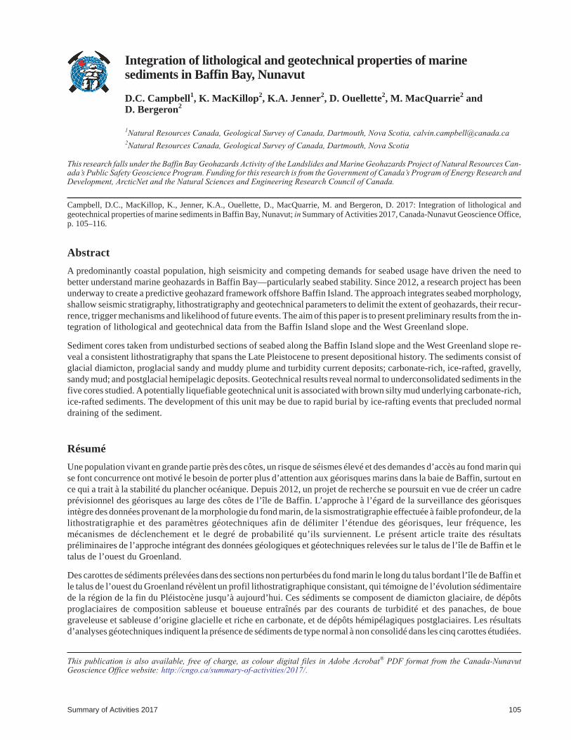
In 2013, several piston cores were col-
lected along the slopes of Baffin Island
and West Greenland within Canadian
waters in order to characterize the shal-
low (<12 m) subsurface geology along
the slope and attempt to develop a shal-
low lithostratigraphic framework.
Campbell et al. (2017) provided the de-
tails of the analysis of these cores as
well as the Late Pleistocene acoustic
and lithostratigraphy of the slope. Con-
currently with the lithostratigraphic re-
search, detailed analysis of the physical
and geotechnical properties of these
sediments was undertaken. This paper
presents some preliminary results of the
integration of lithological and geo-
technical data from four sediment cores
along the Baffin Island slope and one
sediment core from the West Greenland
slope.
Setting
Baffin Bay is an elongated ocean basin
(1300 km long; 450 km wide) that con-
nects northward to the Arctic Ocean via
several channels of the Canadian Arctic
Archipelago and southward to the Lab-
rador Sea and the North Atlantic by way of Davis Strait
(Figure 1). The continental shelf along the western side of
Baffin Bay is 40–60 km wide and up to 300 m deep. Numer-
ous U-shaped transverse troughs, 20–200 km wide and up
to 700 m deep, extend out across the continental shelf to the
shelf break as subsea fjord extensions. The continental slope
is narrow and steep, passing rapidly out onto the relatively
smooth Baffin Bay basin abyssal plain. Unlike many other
106 Canada-Nunavut Geoscience Office
Figure 1: Study area in Baffin Bay showing the locations of cores analyzed forgeotechnical properties. Grey circles signify core locations in Figure 2.
passive continental margins, the Baffin Island slope does
not exhibit well-developed canyon systems. The deepest,
central portion of the basin reaches approximately 2300 m
water depth.
Methods
A total of 28 piston cores were collected by the GSC from
Canadian Coast Guard Ship (CCGS) Hudson during expe-
dition 2013029, predominantly along the western slope of
Baffin Bay but also at the mouth of Disko Bugt, on the
southeastern margin of Baffin Bay (Campbell, 2014). In
addition, 4200 line-km of 3.5 kHz sub-bottom profiler data
were collected with the Knudsen hull-mounted CHIRP
(digital FM sub-bottom profiling system). Campbell et al.
(2017) presented the late Quaternary lithostratigraphy
identified from 21 of these piston cores and illustrated the
alongslope variation of specific lithofacies throughout the
western side of the Baffin Bay margin. A subset of the
2013029 cores was selected for advanced geotechnical
analysis that included cores 2013029-48, 2013029-60,
2013029-75, 2013029-77 and 2013029-82 (Figure 1). This
subset of cores sampled a variety of stratigraphic targets,
selected using high-resolution sub-bottom profiler data;
these sites are deemed representative of the various geolog-
ical settings along the Baffin Island slope and the West
Greenland slope.
Campbell et al. (2017) described in detail the standard core-
processing methods used at GSC-Atlantic. The methods
consist of
• multi-sensor core logging;
• core photography;
• reflectance spectrophotometry;
• visual sample description;
• discrete physical properties measurements (density, ve-
locity and miniature shear vane);
• radiocarbon dating;
• portable X-ray fluorescence; and
• grain-size measurements.
Data from these instruments and methods were used to de-
velop a lithostratigraphic framework for the western Baffin
Island slope and the West Greenland slope.
The geotechnical program was designed to determine the
sediment classification, strength parameters and stress his-
tory to assess slope stability. The multi-sensor core logger
(MSCL) measurements taken at 1 cm intervals were used to
develop density profiles. Miniature laboratory vane (MV)
peak undrained shear strength measurements were taken at
10 cm intervals with remoulded shear strength taken twice
per 150 cm core section. Natural water content was deter-
mined at 75 cm intervals. Plastic and liquid (Atterberg) lim-
its were determined at approximately 1 m intervals with the
selected core depth corresponding to a water content mea-
surement. Stress history and compressibility were deter-
mined from consolidation tests.
The Mohr-Coulomb failure criterion and normalized
strength ratios (Su/ 'v) in the normal consolidated (NC)
stress range were determined from isotropically consoli-
dated undrained (CIU) triaxial tests. A normalized un-
drained shear strength profile can be constructed using the
Mohr-Coulomb failure criterion. The Mohr-Coulomb rela-
tionship uses two strength parameters: the effective cohe-
sion factor (c') and the effective friction angle ( '; Poulos,
1988). The incremental shear strength calculation using the
Mohr-Coulomb relationship is defined as
( )( )( )
S
K A Kc
Au v
f
vo
f
=+ − +
⎛⎝⎜
⎞⎠⎟
+ −σ
φσ
φ
φ'
sin ''
'cos '
sin '
0 01
1 2 1
⎡
⎣
⎢⎢⎢⎢⎢
⎤
⎦
⎥⎥⎥⎥⎥
(1)
where Su is the shear strength, σ′v is the effective vertical
stress, K0 is the coefficient of earth pressure at rest, Af is the
pore pressure parameter at failure, c' is the effective cohe-
sion factor and φ' is the effective friction angle.
The Su/ 'v values from the CIU triaxial tests can also be
used to obtain profiles of undrained shear strength using the
stress history and normalized soil engineering properties
(SHANSEP) procedure (Ladd and Foott, 1974). This pro-
cedure is a system used to characterize the sediment’s un-
drained shear strength with depth.
The geotechnical data were compiled into geotechnical
profiles that comprised down-core plots of lithology, grain
size, density, natural water content, plastic and liquid lim-
its, shear strength, effective overburden stress and
preconsolidation pressure values. Geotechnical units were
assigned based on a comparison of lithology with geotech-
nical index properties.
Results
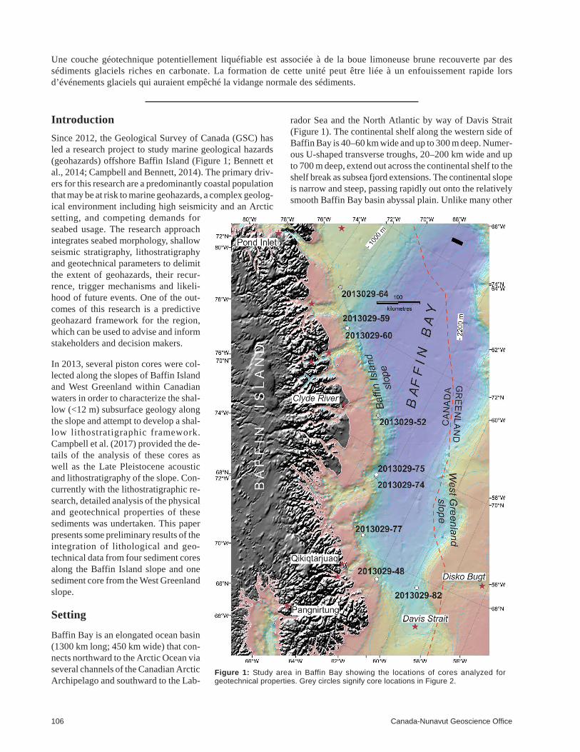
Lithostratigraphy
The late Quaternary geology of the Baffin Island slope is
dominated by trough mouth fans fed by distinct transverse
troughs (Campbell et al., 2017). The Late Pleistocene and
Holocene lithostratigraphic framework consists of a typical
succession of lithofacies that is correlatable along the mar-
gin (Figure 2). This succession consists of proglacial and
glaciomarine deposits composed of basal diamicton
(glaciogenic debris flows) overlain by fine-grained turbid-
ites and meltwater plume deposits, which in turn is overlain
by carbonate-rich, ice-rafted, gravelly, sandy mud. Pro-
glacial deposits transition upsection to postglacial hemi-
pelagic sediments (Figure 2). Although the geophysical
Summary of Activities 2017 107
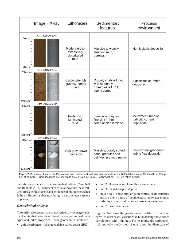
data shows evidence of shallow seabed failure (Campbell
and Bennett, 2014), sediment core data show that these fail-
ures are Late Pleistocene and evidence of Holocene seabed
failure is limited or absent, although data coverage is sparse
in places.
Geotechnical analysis
The surficial sediments are characterized by seven geotech-
nical units that were determined by comparing sediment
types and index properties. These geotechnical units are
• unit 1: carbonate-rich mud with ice-rafted debris (IRD);
• unit 2: Holocene and Late Pleistocene muds;
• unit 3: mass-transport deposits;
• units 4 to 6: show similar geotechnical characteristics
and are likely a mix of hemipelagic, meltwater plume,
turbidity current and contour current deposits; and
• unit 7: basal diamicton.
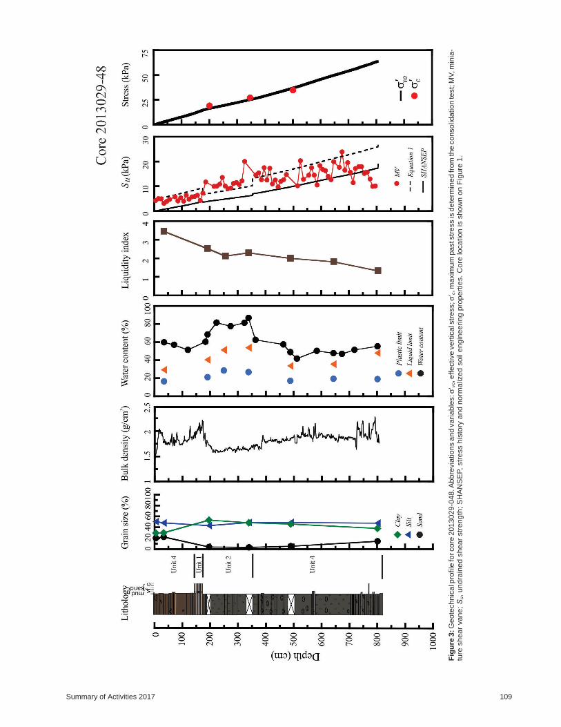
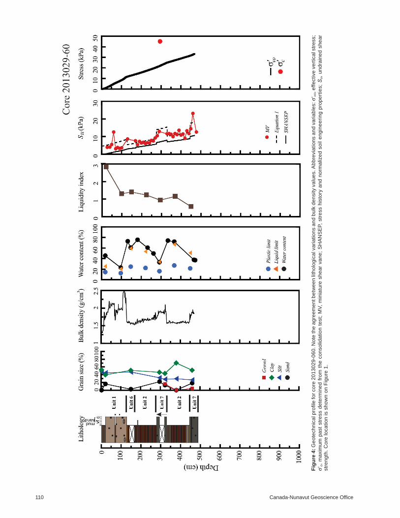
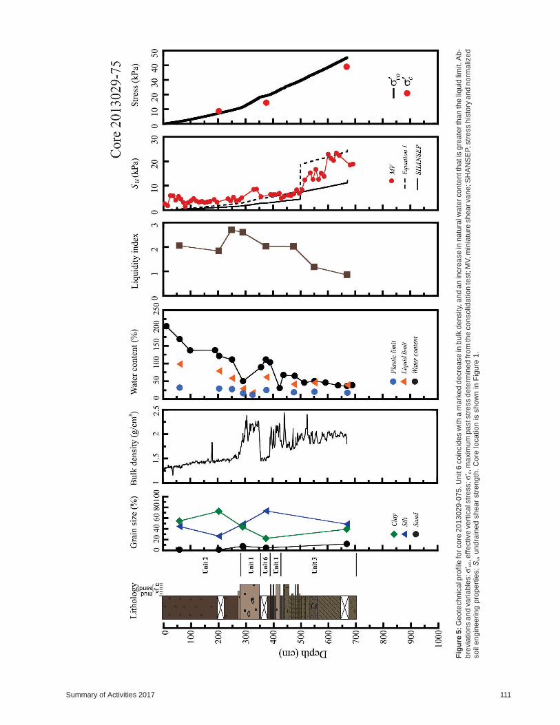
Figures 3–7 show the geotechnical profiles for the five
cores. In most cases, variations in bulk density show direct
correlations with lithology. For example, the carbonate-
rich, gravelly, sandy mud of unit 1 and the diamicton of
108 Canada-Nunavut Geoscience Office
Figure 2: Summary of main Late Pleistocene and Holocene lithostratigraphic units from the Baffin Island slope. Modified from Camp-bell et al. (2017). Core locations are shown as grey circles in Figure 1. Abbreviation: IRD, ice-rafted debris.
Summary of Activities 2017 109
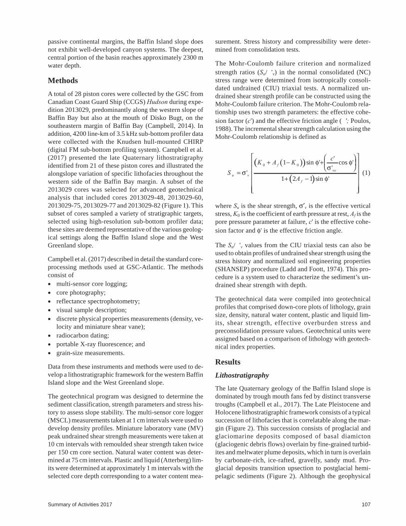
Fig
ure
3:G
eo
tech
nic
alp
rofile
forco
re2
01
30
29
-04
8.A
bb
revia
tio
ns
an
dva
ria
ble
s:σ'
vo,e
ffe
ctive
ve
rtic
als
tre
ss;σ'
c,m
axim
um
pa
ststr
ess
isd
ete
rmin
ed
fro
mth
eco
nso
lida
tio
nte
st;
MV
,m
inia
-tu
resh
ea
rva
ne
;S
u,
un
dra
ine
dsh
ea
rstr
en
gth
;S
HA
NS
EP,
str
ess
his
tory
an
dn
orm
aliz
ed
so
ile
ng
ine
eri
ng
pro
pe
rtie
s.
Co
relo
ca
tio
nis
sh
ow
no
nF
igu
re1
.
110 Canada-Nunavut Geoscience Office
Fig
ure
4:
Ge
ote
ch
nic
alp
rofile
for
co
re2
01
30
29
-06
0.N
ote
the
ag
ree
me
ntb
etw
ee
nlit
ho
log
ica
lva
ria
tio
ns
an
db
ulk
de
nsity
va
lue
s.A
bb
revia
tio
ns
an
dva
ria
ble
s:
σ'vo,e
ffe
ctive
ve
rtic
als
tre
ss;
σ'c,
ma
xim
um
pa
st
str
ess
de
term
ine
dfr
om
the
co
nso
lida
tio
nte
st;
MV
,m
inia
ture
sh
ea
rva
ne
;S
HA
NS
EP,
str
ess
his
tory
an
dn
orm
aliz
ed
so
ile
ng
ine
eri
ng
pro
pe
rtie
s;
Su,
un
dra
ine
dsh
ea
rstr
en
gth
.C
ore
loca
tio
nis
sh
ow
no
nF
igu
re1
.
Summary of Activities 2017 111
Fig
ure
5:G
eo
tech
nic
alp
rofile
forco
re2
01
30
29
-07
5.U
nit
6co
incid
es
with
am
ark
ed
de
cre
ase
inb
ulk
de
nsity,
an
da
nin
cre
ase
inn
atu
ralw
ate
rco
nte
ntth
atis
gre
ate
rth
an
the
liqu
idlim
it.A
b-
bre
via
tio
ns
an
dva
ria
ble
s:σ'
vo,e
ffe
ctive
ve
rtic
als
tre
ss;σ'
c,m
axim
um
pa
ststr
ess
de
term
ine
dfr
om
the
co
nso
lida
tio
nte
st;
MV
,m
inia
ture
sh
ea
rva
ne
;S
HA
NS
EP,str
ess
his
tory
an
dn
orm
aliz
ed
so
ile
ng
ine
eri
ng
pro
pe
rtie
s;
Su,
un
dra
ine
dsh
ea
rstr
en
gth
.C
ore
loca
tio
nis
sh
ow
nin
Fig
ure
1.
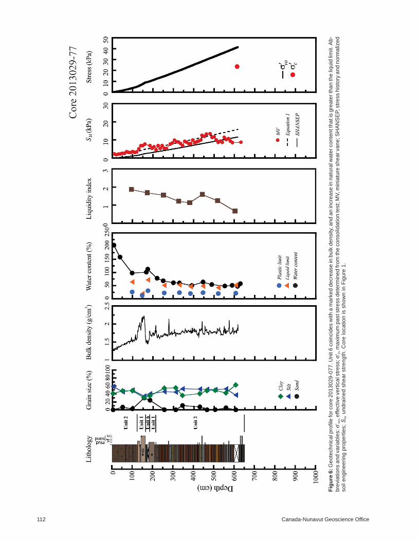
112 Canada-Nunavut Geoscience Office
Fig
ure
6:G
eo
tech
nic
alp
rofile
forco
re2
01
30
29
-07
7.U
nit
6co
incid
es
with
am
ark
ed
de
cre
ase
inb
ulk
de
nsity,
an
da
nin
cre
ase
inn
atu
ralw
ate
rco
nte
ntth
atis
gre
ate
rth
an
the
liqu
idlim
it.A
b-
bre
via
tio
ns
an
dva
ria
ble
s:σ'
vo,e
ffe
ctive
ve
rtic
als
tre
ss;σ'
c,m
axim
um
pa
ststr
ess
de
term
ine
dfr
om
the
co
nso
lida
tio
nte
st;
MV
,m
inia
ture
sh
ea
rva
ne
;S
HA
NS
EP,str
ess
his
tory
an
dn
orm
aliz
ed
so
ile
ng
ine
eri
ng
pro
pe
rtie
s;
Su,
un
dra
ine
dsh
ea
rstr
en
gth
.C
ore
loca
tio
nis
sh
ow
nin
Fig
ure
1.
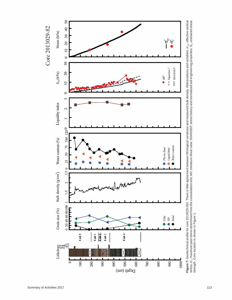
Summary of Activities 2017 113
Fig
ure
7:
Ge
ote
ch
nic
alp
rofile
for
co
re2
01
30
29
-08
2.T
he
reis
little
ag
ree
me
ntb
etw
ee
nlit
ho
log
ica
lva
ria
tio
ns
an
dm
ea
su
red
bu
lkd
en
sity.
Ab
bre
via
tio
ns
an
dva
ria
ble
s:
σ'vo,e
ffe
ctive
ve
rtic
al
str
ess;σ'
c,m
axim
um
pa
ststr
ess
de
term
ine
dfr
om
the
co
nso
lida
tio
nte
st;
MV
,m
inia
ture
sh
ea
rva
ne
;S
HA
NS
EP,str
ess
his
tory
an
dn
orm
aliz
ed
so
ile
ng
ine
eri
ng
pro
pe
rtie
s;S
u,u
nd
rain
ed
sh
ea
rstr
en
gth
.C
ore
loca
tio
nis
sh
ow
nin
Fig
ure
1.
unit 7 have an increased bulk density compared to overly-
ing and underlying deposits. An exception is core
2013029-082 (Figure 7), which shows no relationship be-
tween the carbonate-rich interval and bulk density varia-
tions. This is probably due to lower IRD content in the car-
bonate mud in these cores (Campbell et al., 2017). In
general, consolidation and Atterberg limits show that the
sediments are predominantly normally consolidated to
slightly underconsolidated lean clays.
Seed et al. (2003) suggested that lean silts and clays with
high water content relative to their liquid limit value
(>0.85 LL) may be susceptible to soil liquefaction under
load. Several Atterberg tests reveal that geotechnical unit 6
is potentially liquefiable. Lithologically, unit 6 is brown
silty mud that lies immediately below or between carbon-
ate-rich mud with IRD found in cores 2013029-60,
2013029-75, 2013029-77 and 2013029-82 (Figures 4–7).
The geotechnical profiles for these cores show that unit 6 is
represented by an increase or peak in the trend of the natural
water content that exceeds the liquid limit. This peak in nat-
ural water content usually coincides with a decrease in bulk
density. The best example of this relationship is shown in
core 2013029-75 where unit 6 occurs from 350 to 390 cm
down core, between a 60 cm thick overlying carbonate-rich
bed and a 10 cm thick underlying carbonate-rich bed (Fig-
ure 5).
Discussion
The consistent lithological framework found in undis-
turbed cores (Campbell et al., 2017) suggests that the sedi-
mentary succession on the Baffin Island slope is due to
widespread, regional processes, rather than local pro-
cesses. Ice-rafted, carbonate-rich, gravelly, sandy mud,
found near the top of most cores in this study, has been re-
peatedly identified at various stratigraphic levels through-
out Baffin Bay. Andrews et al. (1998) referred to these beds
as Baffin Bay detrital carbonate (BBDC) events and recog-
nized 7 events over the last 52 ka from several cores in
Baffin Bay; Simon et al. (2012) identified 13 of these
events during the last 112 ka from a core on the lower slope
off Clyde River. The BBDC events correlate to interstadial
periods in δ18O records and reflect major climatic shifts and
rapid retreat of ice streams along the margins of Baffin Bay.
Geotechnical unit 6 occurs stratigraphically either within a
couple of BBDC layers (e.g., core 2013029-75), or imme-
diately below (e.g., core 2013029-60). The geotechnical
characteristics of the unit (i.e., high natural water content
and low density) suggest rapid burial that prevented normal
dewatering of the sediments. Geologically, this observation
agrees with what would be expected during burial by sig-
nificant ice-rafting events. Simon et al. (2012) showed that
sedimentation rates during BBDC events approach 160 cm/
ka, which is 4 to 10 times greater than other times in the
Late Pleistocene and Holocene. The repeated pattern of
BBDC events with depth (Andrews et al., 1998) implies
that geotechnical units similar to unit 6 may be buried by
several tens of metres of sediment along the Baffin Island
slope, and may in fact form detachment surfaces for large
submarine landslide events.
Economic considerations
Coastal populations and marine infrastructure along east-
ern Baffin Island are susceptible to marine geological haz-
ards in the bay. Decisions about infrastructure develop-
ment, emergency plans and public safety should
incorporate the latest research on seabed stability for a
given region. The integration of lithological and geotech-
nical results presented here offer a first step toward being
able to predict where and when submarine landslides may
happen in the future. The outputs from this research should
be used to help formulate future regulations for infrastruc-
ture development, thus helping to ensure the safety of
northerners.
Conclusions
Integration of lithological and geotechnical analyses of
sediment cores from the Baffin Island slope and the West
Greenland slope has revealed linkages between lithology
and geotechnical properties, which ultimately will contrib-
ute to the development of a predictive geological hazard
framework in Baffin Bay. This research has revealed a po-
tentially weak sedimentary layer that likely formed through
the rapid burial of sediments during ice-rafting events that
happened throughout the Late Pleistocene. Inferences from
the glacial geological history of Baffin Bay suggest that
such weak layers may occur at many stratigraphic levels
with depth.
Acknowledgments
The authors thank the officers and crew of CCGS Hudson
expedition 2013029, J. Higgins in the GSC marine core lab-
oratory and several students who assisted in the acquisition
and compilation of data. The authors also thank R. Bennett
for reviewing this paper. This research is funded by the Pro-
gram for Energy Research and Development.
Natural Resources Canada, Lands and Minerals Sector
contribution 20170296
References
Andrews, J.T., Kirby, M.E., Aksu, A., Barber, D.C. and Meese, D.1998: Late Quaternary detrital carbonate (DC-) layers inBaffin Bay marine sediments (67°-74°): correlation withHeinrich events in the north Atlantic?; Quaternary ScienceReviews, v. 17, p. 1125–1137.
Bennett, R., Campbell, D. C. and Furze, M. F. A. 2014: The shal-low stratigraphy and geohazards of the Northeast Baffin
114 Canada-Nunavut Geoscience Office
Shelf and Lancaster Sound. Bulletin of Canadian PetroleumGeology, v. 62, p. 217–231.
Bennett, R., Campbell, D.C., Furze, M.A. and Haggart, J.W. 2014:The shallow stratigraphy and geohazards of the NortheastBaffin shelf and Lancaster Sound; Bulletin of Canadian Pe-troleum Geology, v. 62, p. 217–231.
Campbell, D.C. and Bennett, J.R. 2014: Preliminary results fromrecent investigations of marine geological hazards in BaffinBay, Nunavut and Greenland; in Summary of Activities2013, Canada-Nunavut Geoscience Office, p. 121–128.
Campbell, D.C., Jenner, K.A., Higgins, J. and Piper, D.J.W. 2017:Analysis of piston cores and high-resolution sub-bottomprofiler data, Baffin Bay slope, Nunavut; Geological Surveyof Canada, Open File 8135, 179 p. doi:10.4095/300835
Campbell, D.C. 2014: CCGS Hudson Expedition 2013-029 geo-logical hazard assessment of Baffin Bay and biodiversity as-
sessment of Hatton Basin, August 14–September 16, 2013;Geological Survey of Canada Open File 7594, 122 p.
Ladd, C.C. and Foott, R. 1974: New design procedure for stabilityof soft clays; Journal of the Geotechnical Engineering Divi-sion, American Society of Civil Engineers, v. 100, no. GT7,p. 763–786.
Seed, R.B., Cetin, K.O., Moss, R.E.S., Kammerer, A.M., Wu, J.,Pestana, J.M., Riemer, M.F., Sancio, R.B., Bray, J.D.,Kayen, R.E. and Faris, A. 2003: Recent advances in soil liq-uefaction engineering: a unified and consistent framework;in Proceedings of the 26
thAnnual ASCE Los Angeles
Geotechnical Spring Seminar, Long Beach, California, 72 p.
Simon, Q., St-Onge, G. and Hillaire-Marcel, C. 2012: Late Quater-nary chronostratigraphic framework of deep Baffin Bayglaciomarine sediments from high-resolution paleo-magnetic data; Geochemistry, Geophysics, Geosystems,doi:10.1029/2012GC004272
Summary of Activities 2017 115

116 Canada-Nunavut Geoscience Office