Embed Size (px)
Citation preview

1
Integrating Web-based Activities and Site-based Experiences to Investigate Environmental Issues
Alec M. Bodzin, Lehigh University
Paper presented at the 2010 Association for Science Teacher Education International Conference January 14-16 in Sacramento, CA. USA Abstract This paper describes how the Environmental Education (EE) course at Lehigh University uses a
hybrid approach of instruction using Web-based activities and face-to-face site-based
experiences to primarily focus on the study of environmental issues in the Lehigh River
watershed. Course activities are discussed to illustrate how technology can be used effectively to
support EE and science teaching and learning with prospective and current science teachers. Site
visits to areas of environmental concern support and extend the environmental education
concepts and skills that are initially developed with Web-based materials. Course activities
provide teachers with an in-depth content understanding of local environmental issues as well as
opportunities to explore pedagogical strategies to promote issues-based approaches to learning.
Course materials also take advantage of easily available geospatial information technologies to
foster spatial literacy in the curriculum and support learners with the ability to make use of data
visualizations for analysis and interpretation when examining environmental issues such as
sprawl and land use decision-making. Advantages to using Web-enhanced learning environments
for EE and science teacher education are discussed.

2
Important reserves of oil, gas, and minerals lie deep beneath the seafloor; however, prospecting
and drilling for these poses a major threat to sensitive marine habitats and species. Rising
energy prices coupled with growing concerns about global warming have sharpened the debate
over government funding for offshore drilling versus investing in renewable energy.
Dead zones where fish and most marine life can no longer survive are spreading across the
continental shelves of the world's oceans at an alarming rate as oxygen vanishes from coastal
waters. Scientists point to tons of nitrogen and phosphorus in fertilizers that run-off from farms
and spill into rivers, streams, and bay as well as by fallout from power plants that burn fossil
fuels as contributing factors to these dead zones (Diaz and Rosenberg, 2008).
These are just two of many issues related to the environment that have risen to the top of the
public agenda.
Environmental issues are quite complex, involve conflicting interests and values, and are
often controversial. They frequently involve inter-relationships between economic, social,
cultural, scientific, and political factors. Most issues are open-ended problems in which there is
rarely one correct solution to solve the problem and concern multiple stakeholders who view the
issue from varying perspectives. Solving an environmental issue requires understanding the
context, seeing the problem from varying perspectives, and exploring different possibilities
(Environmental Literacy Council, 2007). The process involves understanding the practicality of
various solutions that are proposed, evaluating scientific evidence, and critically assessing
arguments that may involve economic and environmental consequences. In many cases, both the
subject matter and interpretations of that subject matter are influenced by value judgments.

3
Developing skills for understanding and addressing environmental issues is a key
component of environmental literacy and is advocated by the North American Association for
Environmental Education (NAAEE) as an essential component of preparing preservice teachers
(NAAEE, 2004). Studying environmental issues provides learners with meaningful contexts by
connecting their daily lives and local community issues to content of study (Pennock &
Bardwell, 1994). In addition to understanding underlying science, investigating environmental
issues and their solutions actively involves learners in practicing and improving skills such as
critical reflection, problem-solving and decision making- each important skills inherent to
science teacher education programs. Providing teachers with learning experiences that challenge
and enhance their conceptions of environmental issues by confronting them with alternative
viewpoints can help them to better understand the viewpoints of others, and become aware of
inadequacies and inconsistencies in their own conceptions of environmental issues (Ballantyne &
Bain, 1995).
This paper describes how the Environmental Education (EE) course at Lehigh University
uses a hybrid approach of instruction using Web-based activities and face-to-face site-based
experiences to primarily focus on the study of environmental issues in the Lehigh River
watershed. A watershed is an ideal way to segment the environment for analysis. Watersheds are
scalable, topographic and hydrologic basins that lend themselves to systems analysis. The EE
course is designed to meet Pennsylvania Department of Education program standards for EE
certification and preparation competencies and is offered during the summer to accommodate
schedules of both inservice and preservice teachers.

4
The Hybrid Approach
Studies have shown that participation in outdoor site-based learning experiences is a
promising technique for improving students’ environmental attitudes and knowledge (Bogner,
1998; Crompton & Sellar, 1981; Lisowski & Disinger, 1991; Orion & Hofstein, 1991, 1994).
Learning activities within one’s local environment can have a strong effect on the students’
environmental learning, enhance environmental attitudes, promote a sense of environmental
stewardship, and foster environmental behavior (Bodzin, 2008; Fisman, 2005, Sobel, 2004).
Outdoor field settings have also been successful in teaching awareness of environmental issues.
Strategies such as field trips to selected sites with environmental problems, and case studies are
among the experiences that have been most effective (Howe and Disinger, 1988). Such findings
support the use of site-based activities for learning about environment issues within a defined
watershed area. The local watershed provides for a locale that is a geographically familiar setting
for students and is easily accessible for daylong field trips.
Internet technology can be used to support and extend learning activities rooted in
outdoor, site-based experiential learning (Moore & Huber, 2001). Examples of existing Web-
based learning resources that may be used to promote the teaching and learning of environmental
issues include descriptive photojournals for virtual watershed explorations of locations that are
both accessible and inaccessible by conventional transportation, environmental databases that
can be used for analyzing pollution emissions in local areas, and Web-based inquiry activities
(Bodzin and Cates, 2003). More recently, geospatial information technologies and their products
such as Web-based Geographic Information Systems (GIS) and Google Earth have become
readily available. They are quite accessible as Internet-based interactive mapping applications
with point-and-click access to numerous environmental datasets. Both tools allow for

5
visualizing, mapping, and analyzing multiple layers of georeferenced environmental data. Most
Web-based GIS require little time to learn, drastically reducing the time it takes for educators to
incorporate them into their curricula when compared to desktop-based GIS. No special software
is needed to view these maps other than a Web browser with an Internet connection. The
Geospatial One Stop Web site at http://gos2.geodata.gov/wps/portal/gos contains links to many
national, state, and local Web-based GIS data sites that can be used by educators. Google Earth
is a form of digital or virtual globe that allows users to examine satellite imagery and digital
aerial photographs overlaid on a three dimensional representation of the Earth. The interface is
simple and intuitive and provides a basic set of navigation controls to allow the user to zoom and
pan around the view, as well as the ability to locate a specific place of interest using the search
function. Similar to a Web-based GIS, Google Earth provides a means to overlay thematic data
layers and allows users navigation, data retrieval and visualization functionality. Using Keyhole
Markup Language (KML) or by creating a mashup using Google Maps (for example, see
Lucking, Christmann and Whitting, 2008), data information for any location can be customized
to create a resource for environmental studies and exploration. Google Earth is available via a
free Internet download at http://earth.google.com. In educational settings, both Web-based GIS
and Google Earth have proven to be valuable tools in the process of understanding the
environment and of making responsible environmental decisions (Bodzin & Anastasio, 2006;
Bodzin & Cirruci, in press; National Research Council, 2006).
The hybrid approach combines online instructional supports with in-class and outdoor
face-to-face interactivity to promote learning. There are many advantages to Web-enhanced
learning environments for instruction. When properly designed, students enrolled in Web-
enhanced courses have access to many resources otherwise not accessible in a traditional

6
classroom setting. Web-enhanced classes make learning more accessible and more
accommodating to a variety of learners (Grasha & Yangarber-Hicks, 2000). In addition, a Web-
enhanced hybrid approach to EE learning better serves the needs of students over a Web-based
course since students experience the physical, sensory nature of a live classroom in outdoor
field-based settings (Wright, 2008).
The EE course at Lehigh University takes advantage of using Web-based learning
activities during the first face-to-face class session and also within a series of course modules
that students complete asynchronously. Many of these curricular materials take advantage of
using geospatial technology tools to promote EE learning. The modules include: teaching and
learning about environmental issues; geospatial technologies in environmental education;
designing and implementing water quality curricular projects; environmental laws and
regulations; environmental education essentials; and activity selection for environmental
education. The course modules take advantage of many instructional materials that have been
developed at the Lehigh Environmental Initiative (EI) to promote the teaching and learning of
environmental issues. These materials are primarily located on the Lehigh Earth Observatory
EnviroSci Inquiry Web site (http://www.leo.lehigh.edu/envirosci) and also on other Lehigh EI
project Web sites. Since these materials are both interdisciplinary and Web-based, they are
flexible and portable to use in other disciplines in select secondary and college level courses that
include geology, environmental science, environmental studies, Earth system science, ecology,
or geography.
I have taught the EE course as a lead instructor for the past six years. Each year, the
course is modified to reflect current local environmental issues in the watershed. New Web-
based activities and materials are incorporated each year to keep teachers updated on emerging
7
Web-based tools and instructional resources that can be used to promote environmental learning
with classroom learners. This paper presents and discusses select course activities that were
implemented in 2008. My goal is to illustrate how technology can be used effectively to support
EE teaching and learning with prospective and current science teachers.
Course Activities
The class meets face-to-face for five full days. The first day is spent on-campus at the
University and four other days are spent off-campus at site-based settings investigating
environmental issues in the watershed. The students complete the Web-based modules prior to
the off-campus field sites.
To begin the on-campus day, I ask students to draw a sketch map of the Lehigh River
watershed. The sketch map task provides me with an understanding of the students’ mental
maps in terms of how they spatially view the watershed. Seven of nine students’ watershed
sketch maps included only the southern portion of the Lehigh River, omitting more than half of
the watershed area. Each student accurately labeled the three largest cities - Allentown,
Bethlehem and Easton – on their maps. Surprisingly, only two of the seven students who were
born and raised in the watershed area had fairly detailed sketch maps that included many features
and landmarks. These two students included the Delaware River, specific creek tributaries that
flowed into the Lehigh River, prominent geographic features such as the Lehigh Gap and the
Kittatinny Ridge /Blue Mountain, names and locations of many boroughs, towns, and smaller
cities, farm areas, and industry locations that included a cement plant and Mack trucks. In
addition, one student noted environmental issues on his sketch map that included: “farm-based
fertilizer runoff, industry outflows, housing development runoff (too much pavement), and
recreational usage (litter)”. On the other students’ sketch maps, only one or two such features

8
were included in each sketch map: farms (1), the Kittatinny Ridge/Blue Mountain (1), the Lehigh
Canal (1), Monocacy Creek (1), Bethlehem Steel area (2), the Lehigh Valley Mall (1), the
locations of 4 different bridges over the Lehigh River (1), and the historic Bethlehem area (1).
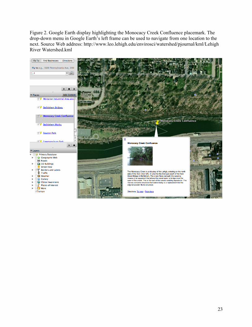
To assist students in understanding the scope and size of the watershed, students use the
Google Earth version of the Lehigh River Photojournal
[http://www.leo.lehigh.edu/envirosci/watershed/pjournal/] (Figure 1). This virtual photojournal
contains yellow pushpin placemarks that denotes specific locations of interest in the Lehigh
River watershed. Clicking on a placemark provides the user with a pop-up box containing a
digital image of the location and text information about the historical and geological significance
about that location (Figure 2). Certain locations briefly describe environmental issues that are of
interest at that location. For example, the Rockport placemark informs the user “Buck Mountain
Creek (Indian Run) is one of four tributaries containing mine drainage entering into the Lehigh
River.” Students are shown how to use the drop-down menu in Google Earth’s left frame to
navigate from one location to the next (Figure 2). Each placemark has been developed with
preset altitudes in the visualization, making specific contextual details easy to observe. In class,
I use Google Earth as a virtual fieldtrip to highlight specific areas that we will later visit during
the course field trips and also highlight other significant locations pertaining to environmental
issues that will not be visited on-site during the course but relate to issues presented in other
course materials (such as the location of sinkholes, sources of abandoned mine drainage, and the
location of proposed wind turbines to be used for energy generation located in areas of raptor
migratory paths). I provide students with exploration time to use the Google Earth visualizations
to further develop their spatial concept of the watershed.

9
Insert Figure 1 about here
Insert Figure 2 about here
I build upon these initial explorations by using a series of Web-based GIS maps of the
Lehigh River watershed area to specific promote aspects of scientific inquiry and environmental
literacy. The GIS maps are disseminated over the Internet using a Web server and are available
at: http://www.leo.lehigh.edu/envirosci/watershed/gis/investigations.html. I use four main topic
areas to help learners understand the complex networks of interactions and dependencies within
watersheds: underlying science, human resources, people centers, and human impacts.
Underlying science focuses on the interdisciplinary study of the complex and interconnected
issues of natural watershed processes, natural resources, populations, and pollution. Human
resources addresses materials consumed or reused by humans to meet their needs, including air,
water, minerals, fuels, building materials, and open space. People centers refers to societal needs
for human activities, including housing, transportation, agriculture, industry, and recreation;
while human impacts attends to how human activities affect both biotic and abiotic conditions of
the environment.
As a way of illuminating these interactions and complexities, each GIS map is organized
to promote inquiry with driving investigative questions about a particular aspect of the Lehigh
Valley watershed. The GIS maps are designed around driving investigative questions that
incorporate two main properties: scalability and portability. Scalability refers to the need for the

10
problems addressed by the learner to be small enough that they can derive conclusions in a
reasonable length of time, but also of sufficient detail that in completing them will understand
concepts that apply to larger and more complex environmental problems. Portability means the
problems addressed in the activities should involve concepts and practices that apply to diverse
locations and situations, allowing learners to extrapolate their derived understandings to
problems other than those to which they were exposed.
One example that I use in the course focused on the question:
Which part of the Lehigh River watershed is the best place to build your new home?
This GIS map (see Figure 3) provides learners with a variety of different data layers one may
wish to examine when selecting a site to build a new home. Learners can display land use types
to determine locations of urban, forested, and agricultural areas in the watershed. Map layers of
major, state, and local roads can be shown to determine transportation patterns throughout the
watershed. The map also contains data about sites that may be prone to natural hazards. A
limestone data layer may be displayed to consider locations that may be prone to sinkhole
occurrences, and a flood plains data layer may be viewed to identify areas where flooding may
occur. Industries that release regulated toxic chemicals into the environment can also be located.
The toxic chemical release inventory data layer provides the name, address, and location of
specific industries, and a complete list of chemicals that each site discharges. Recreational and
preserved land areas including County and PA State Parks and State Game Lands areas may also
be displayed. Census data for each municipality in the watershed for the years 1990 and 2000 are
included and can be explored to determine population growth trends in the area. Using this GIS
activity, students learn there are many factors one must consider when selecting a location to
11
build a new home. Such factors involve natural hazards while others involve anthropogenic
influences that have environmental consequences to a once natural landscape.
Insert Figure 3 about here
Another core on-campus activity involves student groups analyzing and discussing Web-
based environmental education curricular activities that focus on specific environmental issues in
the Lehigh River watershed area. The activity involves the analysis of key characteristics of high
quality environmental education materials (see NAAEE, 2000) with a primary focus on
examining pedagogical features and supports to promote the learning of environmental issues.
This activity is also used to discuss the complexities of particular environmental issues that will
later be revisited during the course field trips and in the course modules. Summaries of the four
Web-based activities are described below.
Sprawl in the Lehigh River Watershed activity
Land use and development in the form of urban or suburban sprawl has always been a
problem in the minds of many people. This activity
(http://www.leo.lehigh.edu/envirosci/enviroissue/sprawl/) uses Web-based GIS maps to explore
sprawl issues in the Lehigh River watershed. Learners are first introduced to historical
population growth patterns in the Lehigh Valley watershed. Next, they are prompted to use a GIS
map to explore trends in population change in the watershed area. The impacts of zoning laws
created by multiple municipalities are then presented. Learners are prompted to use a GIS map
to explore the effects of transportation infrastructure on land use. Information on the effects of
sprawl on human and environmental health is then presented in the activity. Environmental

12
issues that include pollution, effects of creating impervious surfaces, deforestation of riparian
buffers, and the reduction of open spaces and farmlands are discussed. Learners are then guided
to use GIS maps to examine patterns of land use and population centers. Best practices in land
use including smart growth initiatives, brownfield redevelopment, and the creation of
conservation easements are discussed. As a culminating activity, learners are presented with two
differing viewpoints about creating a new highway extension in the area. They are prompted to
select a viewpoint and write a position statement with supporting facts to either favor the
highway extension construction or encourage land preservation.
The Land Use Change Unit
The Land Use Change (LUC) unit (http://www.ei.lehigh.edu/eli/luc/) is designed to assist
students in understanding land use change issues by investigating land use features and issues in
the greater Lehigh Valley area. The LUC activities use Google Earth in conjunction with NASA
and USGS images to assist learners with enhanced qualitative analysis of land use on the earth’s
surface. To understand concepts involved in the formation of urban heat islands, students
investigate how shopping malls change natural environments. They learn how communities can
use certain heat island reduction strategies to reduce the impact of an urban heat island effect.
Students complete a case study of the greater Atlanta area to understand environmental issues
that are typically associated with sprawl. Their investigations continue with a case study of the
Lehigh Valley area in Pennsylvania to identify area land features. They then compare land use
types around five different shopping mall areas using Google Earth to examine the significance
of mall locations. Students then analyze and interpret satellite data images and aerial photographs
to examine landscape changes over time in different locations around the world. In the
culminating Where should we build the new Wal-Mart Supercenter? activity, students take on the

13
role of a Lehigh Valley Planning Commission employee and recommend a plan for locating a
new Wal-Mart Supercenter in the greater metropolitan Lehigh Valley area to have minimal
impact on the environment. They use Google Earth to analyze and evaluate features of different
land areas for proposed development sites and then develop a proposal to apply “smart growth”
principles to their planning decisions and communicate their plan in a simulated planning
commission meeting.
Stockertown Sinkhole Dilemma
In this activity (http://www.leo.lehigh.edu/envirosci/enviroissue/sinkholes), students learn
about the Stockertown sinkholes and decide who should be responsible for compensating
property damage caused by a sinkhole. Students adopt different stakeholder roles and access a
variety of resources that they will use to develop a position statement about who should be
responsible for the investigation and remediation of the sinkholes. They decide what should be
done to solve the sinkhole problem, what might be causing the sinkholes, and what new policies
should be created to protect the interest of homeowners affected by sinkholes. In this activity,
students are responsible for presenting a long-term action plan to prevent and/or remediate
sinkhole destruction during a simulated town hall meeting.
Abandoned Mine Drainage in Pennsylvania
Abandoned Mine Drainage in Pennsylvania
(http://www.leo.lehigh.edu/envirosci/enviroissue/amd/) is a science-technology-society role-
playing debate simulation. In this activity, learners investigate the abandoned mine drainage
(AMD) issue from differing perspectives. In their investigation, they identify AMD problems
caused by Pennsylvania’s long history of coal mining, search for a solution by learning about
active and passive treatment systems, and prepare a statement indicating what they believe is the

14
best course of action for treating abandoned mine drainage in Pennsylvania. In class, a debate is
held in the form of a town meeting for the commonwealth of Pennsylvania. Students evaluate
active and passive treatment options and decide on a course of action to treat and clean up AMD
in Pennsylvania.
Field Trip Site Visits
The course field trips consist of site visits to a variety of locations related to
environmental issues in the watershed area. The first trip is spent with a local conservancy
organization that works to preserve, protect, restore, and enhance the land, water, ecological, and
recreational resources in the Lehigh Valley watershed area. Environmental issues pertaining to
agricultural practices serve as case studies for this day. These include allowing unrestricted
livestock access to streams and the placement of crop fields that extend out to a waterway
making the banks more susceptible to erosion due to a lack of root structure, thus causing
increased sedimentation, which is harmful to fish and aquatic macro-invertebrate habitats. Land
use practices that seek education and compromise with landowners are highlighted. These
include the importance of establishing riparian buffers, in-stream habitat improvement, and
streambank stabilization efforts to minimize erosion and restore the stream to a more "natural"
condition.
The second site visit is to the Lehigh Gap Nature Refuge (LGNF), the location of the
largest EPA Superfund site east of the Mississippi River. At this site, students learn the
historical significance and environmental consequences of two large zinc-smelting plants that
emitted large amounts of sulfur dioxide for over 80 years. The sulfur dioxide emissions reacted
with moisture and gasses in the atmosphere to produce sulfuric acid, which destroyed the plant

15
and microbial life on the nearby Kittatinny Ridge and surrounding areas. When the vegetation
died, approximately 2 feet of topsoil washed off about 2000 acres of the mountain creating a
barren environment with soil containing high concentrations of zinc, cadmium, and lead with a
subsoil devoid of microbes and organic matter (Kunkle, 2004). Since these metals are a potential
human health threat this area was designated a Superfund Site in 1983. At a tour of the site,
students learn how the non-profit LGNF was formed, and the political issues involved with
working collaboratively with the Environmental Protection Agency to consider novel re-
vegetation ideas to restore the ecologically degraded mountainside with mixtures of warm season
grasses.
The third field trip focuses on recycling initiatives in manufacturing and energy production.
The first stop is at a cement manufacturing plant that uses tire derived fuel and plastic derived
fuel - the burning of plastic types 4-7 (that are currently landfilled) - to offset 50% of coal-
burning produced energy and reduce nitrogen oxide emissions. At the plant, students learn about
the many state legislative issues involved in obtaining permits for recycling used in a
manufacturing process. The issues and concerns that were raised during public forums during the
three-year permitting process are discussed. The second stop is at a power generating plant that
uses culm (anthracite waste coal) in addition to other alternative fuel sources to generate
electricity. The site itself is quite unique since it resides on land that once belonged to one of the
largest operating cement plants in world. Environmental permitting issues are highlighted as
students become aware of the legislation involved for using the plant’s ash byproduct to fill
abandoned mine strip pits in order to reclaim the land for other commercial purposes.
The fourth field trip is a canoe trip through ten miles of the Lehigh River to examine land
use practices. Throughout the trip, we discuss environmental issues pertaining to zoning,

16
industrial water discharges, invasive species, pollution and water quality related to urban
development. During the trip, stops are made to gather water quality data to assess the health of
the river.
Discussion
The hybrid approach of using Web-based modules and materials in conjunction with site-
based experiences to investigate environmental issues in the watershed appears to be an effective
course delivery design. The EE course activities provide teachers with an in-depth content
understanding of local environmental issues as well as opportunities to explore pedagogical
strategies to promote issues-based approaches to learning that hopefully will be adopted for later
classroom implementation. The EE course modules are Web-based, making learning quite
accessible and accommodating for the students. A key feature of the EE course design is that it is
“Web-enhanced” and not entirely “Web-based”. An advantage of using a Web-enhanced course
is that learners experience many interactive dynamics with the course instructor in face-to-face
settings at the university and field trip sites. These interactions are highly valuable and cannot be
completely replicated in typical Web-based learning courseware environments (such as
Blackboard or WebCT). Furthermore, learning about an environmental issue at a site-based
location with first-hand accounts from people who are intricately involved with an issue is a
powerful learning experience. While video and Web-base media can be used to learn about
environmental issues, physically being at a location where an issue takes place provides for a
more compelling setting to promote learning and understanding.
The course emphasizes the importance of incorporating inquiry teaching and learning to
promote environmental literacy. It is important that classroom science teachers gain a theoretical
and practical understanding on how to take advantage of both Web-enhanced and Web-based

17
instructional materials to promote essential skill development for understanding and addressing
environmental issues in classroom contexts. The EE course takes advantage of existing Web-
based curricular materials that highlights the complexity of environmental issues that entail
conflicting interests and values and involve understanding the inter-relationships between
economic, social, cultural, scientific, and political factors. The role-playing simulations
described in this paper highlight the open-endedness of environmental problems that concern
multiple stakeholders who view the issue from varying perspectives. Well-designed Web-based
curricular materials can help learners view a problem or issue from varying perspectives, prompt
learners to evaluate scientific evidence, and critically assess arguments that may involve
economic consequences. When learners critically examine a local environmental issue with
inquiry-based methods, they develop conceptual understandings and practices that can be
transferred to related issues in different geographical areas. The Web-based materials and
activities described in this paper have such geographical portability. For example, the concepts
and understandings one learns from the Stockertown Sinkhole Dilemma can be transferred to
understand geoenvironmental engineering and policy issues in other areas of the United States
that contain limestone geology that might be prone to sinkhole occurrences.
Geospatial information technologies can be used to spatially support learners in
environmental education learning activities. Web-based GIS and Google Earth visualizations are
interactive images that are information-rich (they include layers representing various types of
information) and dynamic (learners can explore them by observing spatial patterns and by
selecting more or less detail). These applications support learners with the ability to make use of
data visualizations for analysis and interpretation when examining environmental issues such as
sprawl and land use decision-making.

18
The incorporation of geospatial information technologies in the course activities appears
to be an effective strategy to assist teachers with enhancing their spatial concept of the
watershed. Watershed sketch maps that were produced by the students at the end of the course
were much more expansive and highly detailed compared to their initial sketch maps that were
constructed at the beginning of the course. The end-of-the-course sketch maps included many
geographical features and landmarks (such as sinkhole locations and the limestone belt),
numerous tributaries of the Lehigh River including those with mine drainage in the northern
portion of the watershed, the locations of all sites visited during the field trips, and the names of
many boroughs, towns, and small cities throughout the watershed.
Conclusion
This paper describes how a hybrid approach to environmental education instruction using
Web-based activities and site-based experiences can be used to promote the teaching and
learning of environmental issues in a local watershed with preservice and inservice teachers. In
the course activities presented, teachers learn essential skills for linking EE and science methods
and interdisciplinary content of the natural and social sciences to understand the complexities of
environmental issues based in a local watershed. Developing skills for understanding and
addressing environmental issues is a key component of environmental literacy. Teacher
professional development courses can take advantage of well-designed Web-based curricular
materials to have learners participate in real-world environmental problem solving. Such
materials present environmental issues in appropriate and engaging ways for learners. Instruction
may also take advantage of easily available geospatial information technologies to foster spatial
literacy in the curriculum. In a hybrid course, site visits to areas of environmental concern can
support and extend the environmental education concepts and skills that are initially developed

19
with Web-based materials.
References
Ballantyne, R., and Bain, J. (1995). Enhancing environmental conceptions: an evaluation of
structured controversy learning units. Studies in Higher Education, 20(3), 293-303.
Bodzin, A. (2008). Integrating instructional technologies in a local watershed investigation with
urban elementary learners. The Journal of Environmental Education, 39(2), 47-57.
Bodzin, A., & Anastasio, D. (2006). Using Web-based GIS for Earth and environmental systems
education. The Journal of Geoscience Education, 54(3), 295-300.
Bodzin, A., and Cates, W. (2003). Enhancing preservice teachers’ understanding of Web-based
scientific inquiry. Journal of Science Teacher Education, 14(4), 237-257.
Bodzin, A., & Cirucci, L. (in press). Integrating geospatial technologies to examine urban land
use change: A design partnership. Journal of Geography.
Bogner, F. X. (1998). The influence of short-term outdoor ecology education on long-term
variables of environmental perspective. Journal of Environmental Education, 29(4), 17-
29.
Crompton, J. L., & Sellar, C. (1981). Do outdoor education experiences contribute to positive
development in the affective domain? The Journal of Environmental Education, 12(4),
21-29.
Diaz, R.J., and Rosenberg, R. (2008, August) Spreading dead zones and consequences for marine
ecosystems. Science, 321(5891), 926-929
Environmental Literacy Council (2007). Resources for Environmental Literacy. Arlington, VA:
NSTA Press.

20
Fisman, L. (2005). The effects of local learning on environmental awareness in children: An
empirical investigation. The Journal of Environmental Education, 36(3), 39-50.
Grasha, A., & Yangarber-Hicks, N. (2000). Integrating teaching styles and learning styles with
instructional technology. College Teaching, 48(1), 2-10
Howe, R. W., and Disinger, J. F. (1988). Teaching Environmental Education Using Out-of-
School Settings and Mass Media. ERIC/SMEAC Environmental Education Digest No. 1.
Columbus OH: ERIC Clearinghouse for Science Mathematics and Environmental
Education.
Kunkle, D.R. (2004). Lehigh Gap History and Restoration. Wildlife Information Center:
Slatington, PA
Lisowski, M., & Disinger, J. F. (1991). The effect of field-based instruction on student
understandings of ecological concepts. The Journal of Environmental Education, 23, 19-
23.
Lucking, R. A., Christmann, E. P., & Whitting, M.J. (2008). Make your own mashup maps.
Science Scope, 31(8), 58-61.
Moore, C. J., & Huber, R. A. (2001). Support for EE from the National Science Education
Standards and the Internet. The Journal of Environmental Education, 32(3), 21-25.
National Research Council (2006). Learning to think spatially: GIS as a support system in K-12
education. Washington, DC: National Academy Press.
North American Association for Environmental Education (2004). Guidelines for the initial
preparation of environmental educators. NAAEE: Rock Springs, GA.

21
North American Association for Environmental Education (2000). Environmental education
materials: Guidelines for excellence workbook. Bridging theory and Practice. NAAEE:
Rock Springs, GA.
Orion, N., & Hofstein, A. (1991). The measurement of students' attitudes towards scientific field
trips. Science Education, 75, 513-523.
Orion, N., & Hofstein, A. (1994). Factors that influence learning during a scientific field trip in a
natural environment. Journal of Research in Science Teaching, 31, 1097-1119.
Pennock, M. T., & Bardwell L. V. (1994). Approaching environmental issues in the classroom.
University of Michigan: Ann Arbor, MI.
Sobel, D. (2004). Place-based education: Connecting classrooms and communities. Great
Barrington, MA: The Orion Society.
Wright, J. M. (2008). Web-based versus in-class: An exploration of how instructional methods
influence postsecondary students’ environmental literacy. The Journal of Environmental
Education, 39(2), 33-45.

22
Figure 1. Google Earth display showing the Lehigh River watershed. Yellow pushpin placemarks denote specific locations of interest in the watershed. Source Web address: http://www.leo.lehigh.edu/envirosci/watershed/pjournal/kml/Lehigh River Watershed.kml
23
Figure 2. Google Earth display highlighting the Monocacy Creek Confluence placemark. The drop-down menu in Google Earth’s left frame can be used to navigate from one location to the next. Source Web address: http://www.leo.lehigh.edu/envirosci/watershed/pjournal/kml/Lehigh River Watershed.kml

24
Figure 3. GIS map of the Lehigh River watershed displaying the location of recreational and preserved lands, limestone areas, and industries discharging toxic chemicals. Source Web address: http://128.180.10.97/website/activity3/viewer.htm