Embed Size (px)
Citation preview
Integrated Ocean Drilling ProgramExpedition 302 Preliminary Report
Arctic Coring Expedition (ACEX)
Paleoceanographic and tectonic evolution of the central Arctic Ocean
7 August–13 September 2004
Expedition 302 Scientists
PUBLISHER’S NOTES
Material in this publication may be copied without restraint for library, abstract service, educational, or personal research purposes; however, this source should be appropriately acknowledged.
Citation:Expedition 302 Scientists, 2005. Arctic Coring Expedition (ACEX): paleoceanographic and tectonic evolution of the central Arctic Ocean. IODP Prel. Rept., 302. doi:10.2204/iodp.pr.302.2005
Distribution:Electronic copies of this series may be obtained from the ECORD Web site on the World Wide Web at ecord.org/exp/pubs.html.
This publication was prepared by the Integrated Ocean Drilling Program ECORD Science Operator, as an account of work performed under the international Integrated Ocean Drilling Program, which is managed by IODP Management International (IODP-MI), Inc. Funding for the program is provided by the following agencies:
European Consortium for Ocean Research Drilling (ECORD)
Ministry of Education, Culture, Sports, Science and Technology (MEXT) of Japan
Ministry of Science and Technology (MOST), People’s Republic of China
U.S. National Science Foundation (NSF)
DISCLAIMER
Any opinions, findings, and conclusions or recommendations expressed in this publication are those of the author(s) and do not necessarily reflect the views of the participating agencies, IODP Management International, Inc., or ECORD Management Agency.
March 2005
Expedition 302 Preliminary Report
Expedition 302 Scientists*
Jan Backman†
Co-Chief ScientistDepartment of Geology and GeochemistryStockholm UniversitySE-10691 [email protected]
Kathryn Moran†
Co-Chief ScientistGraduate School of Oceanography and Department
of Ocean EngineeringGraduate School of OceanographyUniversity of Rhode IslandNarragansett RI [email protected]
David McInroy†
Staff ScientistBritish Geological SurveyMurchison HouseWest Mains RoadEdinburgh EH9 3LAUnited [email protected]
Henk Brinkhuis†
Micropaleontologist (dinoflagellates)Geobiology–Botanical PaleoecologyUtrecht University, Faculty of BiologyLaboratory of Paleobotany and PalynologyBudapestlaan 43584 CD UtrechtThe [email protected]
Steve ClemensSedimentologistDepartment of Geological SciencesBrown UniversityProvidence [email protected]
Thomas Cronin†
Micropaleontologist (ostracodes)Eastern Earth Surface Processes TeamU.S. Geological Survey926A USGS National CenterReston VA [email protected]
Gerald Roy Dickens†
Inorganic GeochemistEarth ScienceRice University6100 Main StreetHouston TX [email protected]
Frédérique EynaudMicropaleontologist (foraminifers)Department de Géologie et OcéanographieUniversité Bordeaux 1 Avenue des facultésc/o Bernei Housen33405 Talence [email protected]
Jérôme GattaccecaPaleomagnetistDepartment of GeophysicsCEREGE (CNRS)/University of Aix-Marseille 3BP8013545 Aix-en-Provence Cedex 4 [email protected]
Martin Jakobsson†
Physical Properties/Logging SpecialistDepartment of Geology and GeochemistryStockholm UniversitySE-10691 Stockholm [email protected]
Richard W. Jordan Micropaleontologist (nannofossils and diatoms)Department of Earth and Environmental SciencesFaculty of ScienceYamagata University1-4-12 Kojirakawa-machiYamagata [email protected]
Michael Kaminski†
Micropaleontologist (foraminifers)Department of Earth SciencesUniversity College LondonGower Street London WC1E 6BTUnited [email protected]
*Addresses at time of expedition, except where updated by the participants.†
3
Participated in shipboard operations.

Expedition 302 Preliminary Report
John KingPaleomagnetistGraduate School of OceanographyUniversity of Rhode IslandNarragansett Bay CampusNarragansett RI [email protected]
Nalân KocMicropaleontologist (diatoms)Norwegian Polar InstitutePolar Environmental CenterN-9296 Tromsø[email protected]
Nahysa C. MartinezInorganic GeochemistDepartment of Earth SciencesBoston University685 Commonwealth AvenueBoston MA [email protected]
Jens Matthiessen†
Micropaleontologist (dinoflagellates)Department of GeosystemsAlfred Wegener Institute for Polar and Marine
Research (AWI)PO Box 120161D-27515 [email protected]
Theodore C. Moore Jr.†
Micropaleontologist (radiolarians)Geological SciencesUniversity of MichiganAnn Arbor MI [email protected]
Matthew O’Regan†
Stratigraphic Correlator Graduate School of OceanographyUniversity of Rhode IslandBay CampusSouth Ferry RoadNarragansett RI [email protected]
Heiko Pälike†
Stratigraphic CorrelatorSchool of Ocean and Earth ScienceUniversity of SouthamptonSouthampton Oceanography CenterEuropean WaySouthampton SO14 3ZHUnited [email protected]
Brice Rea†
Department of Geography and EnvironmentSchool of GeosciencesUniversity of AberdeenElphinstone RoadAberdeen AB24 3UFUnited [email protected]
Domenico Rio†
Micropaleontologist (nannofossils)Department of Geology, Paleontology and
GeophysicsUniversity of Padova1 Via Giotto35137 [email protected]
Tatsuhiko SakamotoPhysical Properties/Logging SpecialistInstitute for Research on Earth EvolutionJapan Agency for Marine-Earth Science and Tech-
nologyNatsushima-cho 2-15Yokosuka 237-0061 [email protected]
David C. Smith†
MicrobiologistGraduate School of OceanographyUniversity of Rhode IslandSouth Ferry RoadNarragansett RI [email protected]
4
Expedition 302 Preliminary Report
Ruediger SteinOrganic Geochemist/SedimentologistDepartment of GeosciencesAlfred Wegener Institute for Polar and Marine
Research (AWI)Columbusstrasse 27568 [email protected]
Kristen E.K. St. JohnSedimentologistDepartment of Geology and Environmental ScienceMSC 7703James Madison University Harrisonburg VA [email protected]
Itsuki Suto†
Micropaleontologist (diatoms)Institute of Life and Environmental ScienceUniversity of TsukubaTennoudai 1-1-1, TsukubaIbaraki [email protected]
Noritoshi SuzukiSedimentologistInstitute of Geology and PaleontologyGraduate School of ScienceTohoku UniversityAramakiAoba, Aoba-kuSendai City [email protected]
Kozo Takahashi†
Micropaleontologist (radiolarians/silicoflagellates)
Department of Earth and Planetary SciencesKyushu UniversityHakozaki 6-10-1 Higashi-kuFukuoka [email protected]
Mahito Watanabe SedimentologistInstitute of GeoscienceNational Institute of Advanced Industrial Science
and Technology (Geological Survey of Japan)AIST Tsukuba Central 7Higashi-1-1-1, TsukubaIbaraki [email protected]
Masanobu YamamotoOrganic GeochemistGraduate School of Environmental Earth ScienceHokkaido UniversityKita-10Nishi-5, Kita-kuSapporo [email protected]
ECORD Science Operator Personnel (and Subcontracts)Alister SkinnerOperations ManagerBritish Geological SurveyMarine OperationsEngineering and Core Store2a Nivensknowe RoadLoanhead EH20 9AUUnited [email protected]
Davie BaxterDrilling Supervisor/EngineerBritish Geological SurveyMarine OperationsEngineering and Core Store2a Nivensknowe RoadLoanhead EH20 9AUUnited [email protected]
5

Expedition 302 Preliminary Report
Dave WallisElectrical EngineerBritish Geological SurveyMarine OperationsEngineering and Core Store2a Nivensknowe RoadLoanhead EH20 9AUUnited [email protected]
Colin BrettDeputy Operations ManagerBritish Geological SurveyMurchison HouseWest Mains RoadEdinburgh EH9 3LAUnited [email protected]
Dan EvansESO Science ManagerBritish Geological SurveyMurchison HouseWest Mains RoadEdinburgh EH9 3LAUnited [email protected]
Colin GrahamDatabase ManagerBritish Geological SurveyMurchison HouseWest Mains RoadEdinburgh EH9 3LAUnited [email protected]
Graham TullochDrilling SupervisorBritish Geological SurveyMurchison HouseWest Mains RoadEdinburgh EH9 3LAUnited [email protected]
Hans-Joachim Wallrabe-AdamsDatabase OperatorUniversity of BremenMarum WDC-MARE/PANGAEALeobener StrasseD-28359 [email protected]
Alex WuelbersCore CuratorBremen Core RepositoryKonsul-Smidt-Strasse 30D-28217 [email protected]
Alain KayoSchlumberger ReservoirEvaluation WirelinePitmedden NorthKirkton AvenueDyceAberdeen AB21 0BFUnited [email protected]
Ship MastersTomas ÅrnellMaster of OdenB&N Nordsjöfrakt ABPO Box 32SE-471 21 Skä[email protected]
Jørgen E. HaaveMaster of Vidar VikingB&N Viking Icebreaking and OffshoreMarkensgate 9Box 204N-4662 [email protected]
Stanislav SmithMaster of Sovetskiy SoyuzMurmansk Shipping Company15 Kominterna str.Murmansk 183836Russia
Seacore PersonnelTony HallidayDrilling [email protected]
Danny Bennets
Shaun Curnow
Roy Mitchell
Julian Pearce
6
Expedition 302 Preliminary Report
Allan Pope
Graeme Thomas
Pete Thornton
Lynton Williams
SPRS Personnel (and Subcontracts)Anders BackmanFleet ManagerSwedish Maritime AdministrationSE-60178 Norrkö[email protected]
Anders VikströmAssociate Fleet CaptainSwedish Maritime AdministrationSE-60178 Norrkö[email protected]
Ulf HedmanLogistics ManagerThe Swedish Polar Research Secretariat PO Box 50 003SE-10405 [email protected]
Anders KarlqvistInformation OfficerThe Swedish Polar Research Secretariat PO Box 50 003SE-10405 [email protected]
John FarrellInformation OfficerUniversity of Rhode IslandBay Campus Box 52 South Ferry Road Narragansett RI [email protected]
Ice Management TeamArno KeinonenIce Management DirectorAKAC Inc.877 Goldstream Avenue #311Victoria BC V9B 2X8
Göran LiljeströmDeputy Ice Management DirectorSwedish Maritime AdministrationSE-60178 NorrköpingSweden [email protected]
Max ShirleyIce MasterAKAC Inc.877 Goldstream Avenue #311Victoria BC V9B 2X8 Canada
Valentin DavidjanIce MasterMurmansk Shipping Company15 Kominterna str.Murmansk 183836Russia
Roger PilkingtonIce Observer/ForecasterAKAC Inc.877 Goldstream Avenue #311Victoria BC V9B 2X8 Canada [email protected]
Johan SöderqvistIce Observer/ForecasterSwedish Meteorological and Hydrological [email protected]
Andrei MasanovIce ObserverArctic and Antarctic Research Institute38 Bering str.St. Petersburg 199397Russia [email protected]
Alexander YulinIce ObserverArctic and Antarctic Research Institute38 Bering Str.St. Petersburg 199397Russia
Igor SheikinIce ObserverArctic and Antarctic Research Institute38 Bering str.St. Petersburg [email protected]
7
Canada [email protected]

Expedition 302 Preliminary Report
Other SPRS PersonnelSven StenvallHelicopter PilotKallax Flyg ABVargbackenvägen 1SE-94294 [email protected]
Thomas RönnkvistHelicopter Pilot
Jim HolmströmHelicopter Technician
Bertil [email protected]
Sandy [email protected]
Per FrejvallIT and Communications ManagerFrejvall KonsultFreyvägen 42SE-13338 Saltsjö[email protected]
Ingemar PomlinEricsson ResponseGuildford Business ParkGuildford GU2 8SGUnited [email protected]
TechniciansLuzie SchneidersGeochemistry TechnicianUniversity of [email protected]
Åsa WallinLaboratory TechnicianDepartment of Geology and GeochemistryStockholm UniversitySE-10691 [email protected]
Stockholm University PersonnelTom FlodénSeismic [email protected]
Arne LifElectronics [email protected]
Outreach Program PersonnelEric ZetterbergTeacher Järfälla NT-GymnasiumMälarvägen 2SE-17742 Järfä[email protected]
Kathy CouchonTeacher Narragansett Pier Middle School235 South Pier RoadNarragansett RI [email protected]
Hannes von der FechtArtistHochschule für Künste BremenAm Speicher XI 8D-28217 [email protected]
ObserverAlexey KrylovObserverDepartment of Lithology and GeochemistryVNIIOkeangeologia1 Angliysky prSt. Petersburg [email protected]
8
Expedition 302 Preliminary Report
$% $
The first scientific drilling expedition to the central Arctic Ocean was completed inlate summer 2004. Integrated Ocean Drilling Program Expedition 302, Arctic CoringExpedition (ACEX), recovered sediment cores deeper than 400 meters below seafloor(mbsf) in water depths of ~1300 m at the top of the world, only 250 km from theNorth Pole.
ACEX’s destination was the Lomonosov Ridge, hypothesized to be a sliver of conti-nental crust that broke away from the Eurasian plate at ~56 Ma. As the ridge movednorthward and subsided, marine sedimentation occurred and continued to thepresent, resulting in what was anticipated (from seismic data) to be a continuous pa-leoceanographic record. The elevation of the ridge above the surrounding abyssalplains (~3 km) ensures that sediments atop the ridge are free of turbidites. The pri-mary scientific objective of ACEX was to continuously recover this sediment recordand to sample the underlying sedimentary bedrock by drilling and coring from a sta-tionary drillship.
The biggest challenge facing ACEX was maintaining the drillship’s location whiledrilling and coring 2–4 m thick sea ice that moved at speeds approaching half a knot.Sea-ice cover over the Lomonosov Ridge moves with the Transpolar Drift and re-sponds locally to wind, tides, and currents. Until now, the high Arctic Ocean Basin,known as “mare incognitum” within the scientific community, had never beforebeen deeply cored because of these challenging sea-ice conditions.
Initial offshore results, based on analysis of core catcher sediments, demonstrate thatbiogenic carbonate only occurs in the Holocene–Pleistocene interval. The upper ~170m represents a record of the past ~15 m.y. composed of sediment with ice-rafted sed-iment and occasional small pebbles, suggesting that ice-covered conditions extendedat least this far back in time. Details of the ice cover, timing, and characteristics (e.g.,perennial vs. seasonal) await further study. Earlier in the record, spanning a majorportion of the Oligocene to late Eocene, an interruption in continuous sedimentationoccurred. This may represent a hiatus encompassing a time interval of nondepositionor an erosional episode that removed sediment of this age from the ridge. The sedi-ment record during the middle Eocene is of dark, organic-rich siliceous composition.Isolated pebbles, interpreted as ice-rafted dropstones, are present down to 239 mbsf,well into the middle Eocene section. An interval recovered around the lower/middleEocene boundary contains an abundance of Azolla spp., suggesting that a fresh/low
Expedition 302 Preliminary Report
salinity surface water setting dominated the region during this time period. Althoughpredictions based on geophysical data had placed the base of the sediment column at50 Ma, drilling revealed that the latest Paleocene to earliest Eocene boundary interval,well known as the early Eocene Thermal Maximum (EETM), was recovered. Duringthe EETM, the Arctic Ocean was subtropical with warm surface ocean temperatures.ACEX penetrated into the underlying sedimentary bedrock, revealing a shallow-waterdepositional environment of Late Cretaceous age.
& " &
'
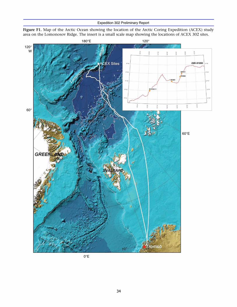
Ever since Bruce Heezen and Maurice Ewing recognized, in their 1961 paper, that themid-ocean rift system extended from the North Atlantic into the Arctic Ocean, it hasbeen assumed that the Lomonosov Ridge (Fig. F1) was originally a continental frag-ment broken off of the Eurasian continental margin. Aeromagnetic surveys of theEurasian Basin have since mapped a remarkably clear pattern of magnetic lineationswhich can be interpreted in terms of seafloor spreading along the Gakkel Ridge sinceChron C24 at ~53 Ma (Wilson, 1963; Vogt et al., 1979; Kristoffersen, 1990). If we com-pensate for that motion of the seafloor, the Lomonosov Ridge is brought into juxta-position with the Barents/Kara Sea margin in early Cenozoic reconstructions. Zircon-bearing bedrock samples from the Lomonosov Ridge at 88.9°N yield a latest Permian(~250 Ma) age (Grantz et al., 2001). The only known source for zircons aged ca. 250Ma in the circum-Arctic is in the post-tectonic syenites of northern Taymyr Peninsulaand nearby islands in the Kara Sea, lending support to the tectonic model in whichthe ridge is interpreted to be a continental sliver that separated from the Eurasianplate.
As the Lomonosov Ridge moved away from the Eurasian plate and subsided, sedimen-tation on top of this continental sliver began and continued to the present, providinga >400 m thick stratigraphic sequence. The elevation of the ridge above the surround-ing abyssal plains (~3 km) indicates that sediments on top of the ridge have been iso-lated from turbidites and originate from hemipelagic, biogenic, eolian, and/or ice-rafted input.
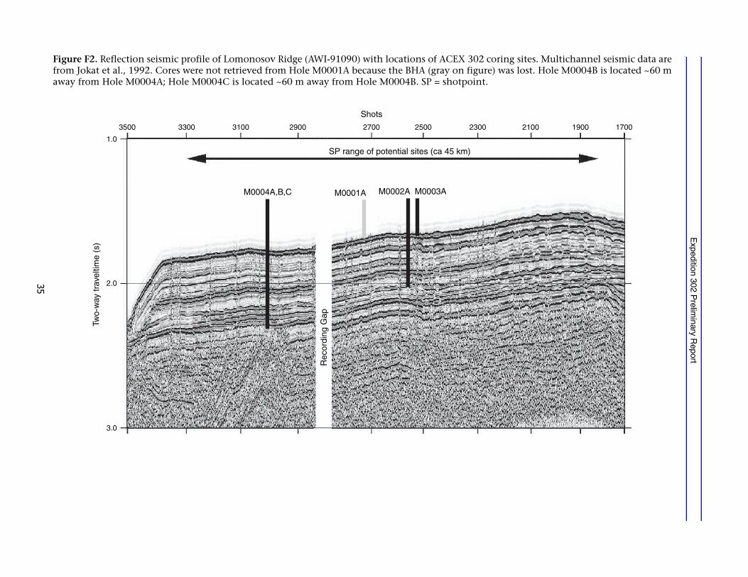
Two key seismic profiles (AWI-91090 and AWI-91091) were acquired across the Lo-monosov Ridge in about 8/10 sea-ice cover in 1991 (Jokat et al., 1992). At 88°N in ~1km of water, the ridge is 80 km wide with a 410 m thick section of acoustically strat-
Expedition 302 Preliminary Report
ified sediments that cap the ridge above an unconformity (Fig. F2). Below this uncon-formity, sediments are present in down-faulted asymmetric half-grabens.
Several dozen short cores (<10 m) of Pleistocene and Holocene age exist from the cen-tral parts of the Lomonosov Ridge, indicating average sedimentation rates of ~10 m/m.y. (e.g., Gard, 1993; Jakobsson et al., 2000, 2001; Backman et al., 2004).
Prior to the Arctic Coring Expedition (ACEX), little information was available aboutpre-Pleistocene paleoenvironments in the central Arctic Ocean. Temperate marineconditions existed during the Late Cretaceous (Campanian–Maastrichtian) based onevidence provided by silicoflagellates and diatoms from three short T-3 and CESARcores, all retrieved from the Alpha Ridge in the Amerasian Basin (Clark et al., 1980;Bukry, 1981; Thiede et al., 1990). One 3.64 m long core (F1-422) containing a 1.65 msection with middle Eocene diatoms and silicoflagellates provided the sole evidencefor early Cenozoic marine conditions in the Arctic (Bukry, 1984; Ling, 1985).
( #
The history of Arctic paleoceanography is so poorly known that we can look at therecovery of any material as a true exploration that will, by definition, increase ourknowledge and understanding of this critical region. The key objective of ACEX wasto recover a continuous ~450 m thick sediment sequence including the upper part ofthe underlying acoustic basement (bedrock) from the crest of the Lomonosov Ridge.The overall, primary scientific goal was to determine the paleoenvironmental devel-opment in the central Arctic Ocean during post-Paleocene times and to decipher itsrole in the global climate evolution. A secondary scientific goal was to acquire infor-mation about the early tectonic evolution of the Eurasian Basin.
Specific paleoceanographic objectives are to:
• Determine the history of ice rafting and sea ice;
• Study local versus regional ice sheet development;
• Determine the density structure of Arctic Ocean surface waters, the nature of NorthAtlantic, and the conveyor and onset of Northern Hemisphere glaciation;
• Determine the timing and consequences of the opening of the Bering Strait;
• Study the land-sea links and the response of the Arctic to Pliocene warm events;
• Investigate the development of the Fram Strait and deepwater exchange betweenthe Arctic Ocean and Greenland/Iceland/Norwegian Sea; and
Expedition 302 Preliminary Report
• Determine the history of biogenic sedimentation.
The tectonic objectives are focused on ridge evolution. Specific tectonic objectives fordrilling on the Lomonosov Ridge are to:
• Investigate the nature and origin of the Lomonosov Ridge by sampling the oldestrocks below the regional unconformity in order to establish the pre-Cenozoic en-vironmental setting of the ridge and
• Study the history of rifting and the timing of tectonic events that affected the ridge.
The biggest challenge facing ACEX was maintaining the drillship’s location duringdrilling and coring in moving, heavy sea ice. Sea-ice cover over the Lomonosov Ridgemoves with the Transpolar Drift and is affected by local responses to wind, tides, andcurrents. Until now, the high Arctic Ocean Basin, known as “mare incognitum” to thescientific community, had never been deeply cored before because of these challeng-ing sea-ice conditions.
Plans for this first-ever event were carefully crafted over several years and included afleet of three icebreaker-class ships: a drilling vessel, the Vidar Viking, which remainedat a fixed location and suspended over 1600 m of drill pipe through the water columnand into the underlying sediments; a Russian nuclear icebreaker, Sovetskiy Soyuz; andthe diesel-electric icebreaker Oden. The Sovetskiy Soyuz and Oden protected the VidarViking by breaking “upstream” floes into small bergy bits to allow the Vidar Viking tostay positioned to drill and recover the sediment cores.
This strategy was successful. Planners had predicted that the fleet could maintain thedrillship’s station for up to 2 full days, yet the stationkeeping ability was stretched tomore than 9 consecutive days. The three ships coordinated their efforts through acentral Fleet Manager, at times on a minute-to-minute basis. The fleet kept the VidarViking on location in 9/10, multiyear ice for up to 9 days—a landmark feat that hasempowered scientists to continue to explore this least known of our oceans throughscientific ocean drilling for many years to come.
The Sovetskiy Soyuz conducted the first attack on oncoming heavy floes, whereas Odenwas the last defense in protecting the drilling operation against the oncoming ice (Fig.F3). During these defensive operations, the officers on the Vidar Viking kept stationby manually driving the powerful thrusters with the bow continuously maneuvered
Expedition 302 Preliminary Report
to head into the direction of the oncoming ice. The ice management defense strate-gies were continuously updated with information from a full-time ice and weatherforecast team onboard the Oden and Sovetskiy Soyuz.
Coring operations were conducted by Seacore, Ltd., using a specially built drill rig forthe Vidar Viking. Coring tools were provided by the British Geological Survey. Coreswere collected on the Vidar Viking from five boreholes drilled to a maximum depth of428 meters below seafloor (mbsf). A ~160 m record of wireline geophysical logs wascollected in one borehole.
The cores, collected in plastic liners, were sealed for postexpedition analyses onshoreat the Integrated Ocean Drilling Program repository in Bremen, Germany. Before theywere stored, cores were analyzed for physical properties using Geotek’s non-destructive multisensor track. Selected intervals were sampled to extract pore waterand microbiology samples. During the expedition, core catcher samples were rou-tinely transferred to the Oden twice a day for analyses that included micropaleontol-ogy, stratigraphy, petrophysics, chemistry, and sedimentology.
)& *
##+
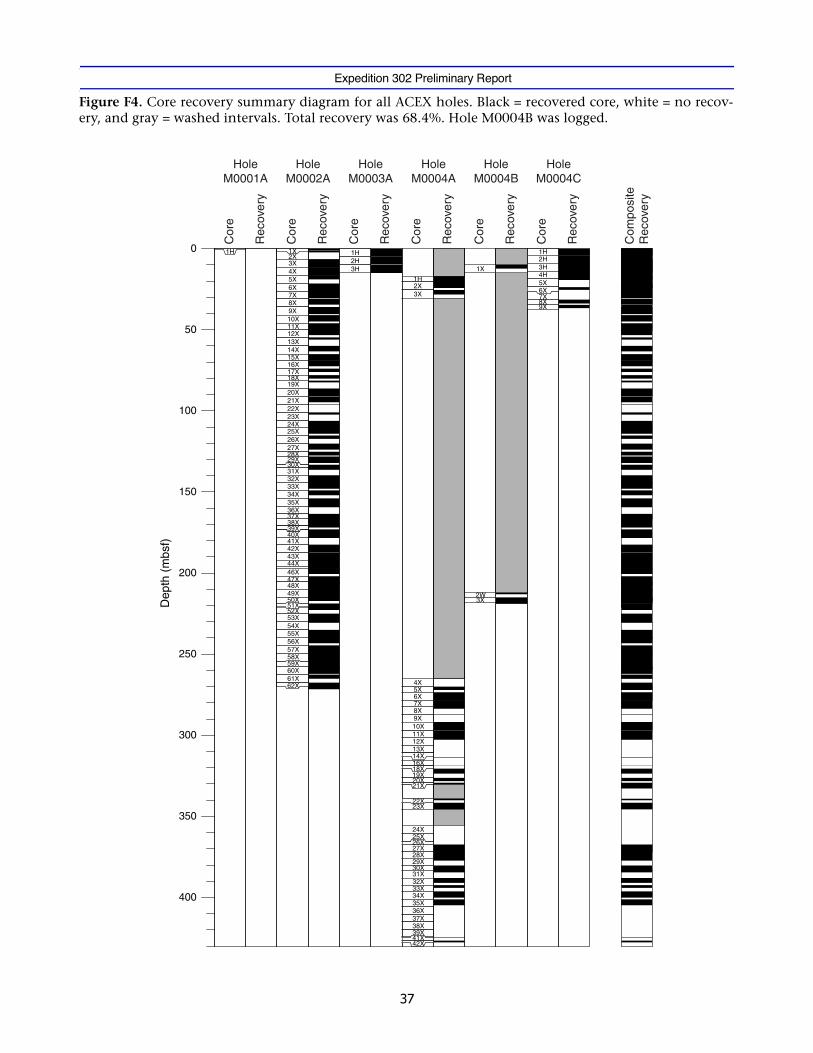
Cores were recovered in five holes across three sites (Holes M0002A, M0003A,M0004A, M0004B, and M0004C) (Tables T1, T2, T3), with a total recovery of 68.4%,which precluded the complete recovery of the entire sediment drape, a key objective(Fig. F4). The first hole at Site M0001 was abandoned because a bottom-hole assembly(BHA) was lost (see “Site Operations” in “Operations”). Logging was attempted intwo holes and data were collected over a 160 m interval in Hole M0004B.
The ACEX sites are situated within 15.7 km of each other on seismic Line AWI-91090and have been treated as a single site because of the internally consistent seismicstratigraphy across that distance (Fig. F2). A limited amount of site-to-site correlationwas conducted, based primarily on physical property data (gamma ray attenuationbulk density, magnetic susceptibility, P-wave velocity, and electrical resistivity) gener-ated using a multisensor core logging system. Site correlation was also aided by litho-logic descriptions and high-resolution geochemical pore water measurements ofchiefly ammonia concentrations and alkalinity. In terms of recovered stratigraphy,the bulk of material was provided by Hole M0002A for the upper half of the 428 m
Expedition 302 Preliminary Report
long stratigraphic record and Hole M0004A for the lower half, with correlation madepossible by a short overlap between the two holes. The other holes recovered multipleportions of the upper ~30 m and allowed construction of a composite depth scale andspliced record for this short interval.
$
The overall goal of ACEX was to study Arctic paleoceanography in order to under-stand this region’s past climate and its impact on Earth’s climate over the Cenozoic,with particular emphasis on the change from the “greenhouse” world of the Eoceneto the “icehouse” world of today.
The prospectus outlined the methods to achieve this goal. The primary method wasto apply a well-known and effective technique for complete core recovery: continu-ous piston core and extended core barrel sampling in multiple holes at one site. Thistechnique results in a continuous stratigraphic record. ACEX was not able to applythis method during Expedition 302, as no sites in ACEX were multiply cored (TableT1; Fig. F4). In addition, single hole penetrations suffered from relatively low recov-ery. The average core recovery for all holes was 68.4%; below 270 m (~47 Ma) to totaldepth at 428 mbsf, the recovery dropped to 43.1%. This lower recovery intervalspanned two of the most important ACEX events: the Azolla and the early EoceneThermal Maximum (EETM), resulting in incomplete records for both.
The early results of ACEX show that further analyses of the sediment and basementcores will contribute to five of the seven major paleoceanographic objectives andboth of the tectonic objectives. The degree to which advances are made depends onthe level of detail that can be extracted from the sediment record. Because of the lowcore recovery, an average of one-third of this detailed record is missing, thus reducingthe chances for fully meeting each objective.
The predicted lithologies were encountered. Stratigraphically, the ACEX sites show amajor hiatus spanning the transition from the Neogene to the Paleogene. The overallage span of the sediment section was greater than predicted by a few million years.The overall impact of these two factors is limited. The hiatus means that paleoceano-graphic analyses over this missing interval cannot occur, but interpretation of theoverall time and causal mechanisms will contribute to furthering our understandingof the tectonic evolution. The longer age interval will allow us to interpret the paleo-climate conditions during the EETM at a position close to the North Pole.
Expedition 302 Preliminary Report
Among the seven specific paleoceanographic objectives, results from ACEX will beused to determine the history of ice rafting and sea ice; study local (e.g., Svalbard) ver-sus regional ice sheet development; reconstruct the density structure of surfacewaters, the nature of North Atlantic conveyor, and the onset of Northern Hemisphereglaciation; make contributions to the investigation of the development of the FramStrait and deepwater exchange between the Arctic and the world ocean; and deter-mine the history of biogenic sedimentation. Because one of the hiatuses in the sedi-ment record may span the Pliocene, it is possible that ACEX results may not be usefulin the study the land-sea links and the response of the Arctic to Pliocene warm events.Also, the lack of a carbonate stratigraphic record precludes study of the timing andconsequences of the opening of the Bering Strait. Biogenic carbonate occurs onlyrarely and occasionally in the upper 18 m of the sediment column. The disappearanceof carbonate occurs together with a decrease in pH and alkalinity, suggesting that thelack of cocolithophorids, calcareous foraminifers, and ostracodes in deeper sedimentsis caused by dissolution.
ACEX results partially addressed the two tectonic objectives. The regional unconfor-mity was penetrated but not sampled except for a small bag sample. Fossils from thissample constrain timing of the initiation of rifting to between 80 Ma and the oldestage of the sediment overlying the unconformity at 58 Ma.
Early results reveal that the upper sediments hold a record of sea-ice distribution inthe Arctic Ocean well into the middle Miocene. The situation is different in older, un-derlying cores where dark, organic-rich sediments contain abundant diatoms, ebridi-ans, silicoflagellates, and dinoflagellate cysts, indicating a middle Eocene age and anenvironment partly characterized by ice-free, warmer surface ocean waters. Isolatedpebbles, interpreted as dropstones, were observed downhole to ~239 mbsf, suggestingthe presence of at least seasonal ice throughout most of the middle Eocene.
Abundant megaspores of the hydropterid fern Azolla occur at the early/middle Eoceneboundary, suggesting strongly reduced surface water salinity or perhaps even a briefepisode of freshwater conditions at the surface. It is yet not known if the Azolla sporesrepresent an indigenous signal, indicating fresh to nearly fresh surface waters, or ifthey have been transported into a marine Arctic basin from neighboring freshwatersystems. However, the sporadic and rare presence of radiolarians suggests that the Arc-tic’s surface water salinities indeed were reduced throughout the Eocene interval con-taining biosilica. Biosilica is not preserved before the late early Eocene. Thedinoflagellate species Apectodinium augustum is abundantly present at ~380 m in py-

Expedition 302 Preliminary Report
rite-rich mudstones, indicating that the EETM interval was partly recovered. Duringthis thermal maximum, the Arctic Ocean experienced surface temperatures on the or-der of 20°C.
,
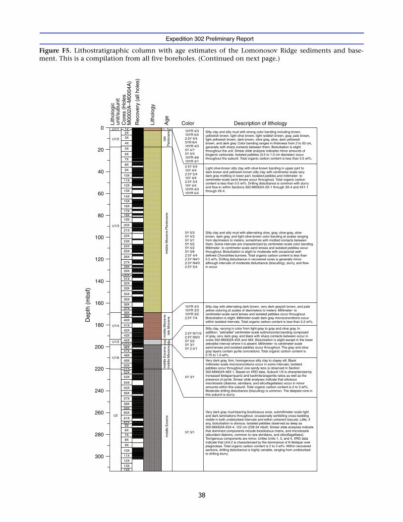
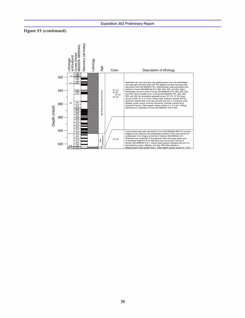
The lithostratigraphy of the Lomonosov Ridge sites is described in terms of four units(Fig. F5). Recovered sediments, ranging in age from Holocene to Late Cretaceous (0–428 mbsf), are dominated by lithogenic material. With the exception of sandy lenses,the dominant terrigenous component of all lithologic units is fine grained, rangingfrom clays to silty muds indicative of predominantly low energy marine environ-ments. The upper ~220 mbsf comprises soft to hard silty clay with colors varying fromlight brown to olive green to gray (Unit 1). Isolated pebbles are present throughoutUnit 1, with the deepest pebble observed in Unit 2 (239.34 mbsf). This may indicatethe presence of at least seasonal sea ice as early as the middle Eocene. Lithologic unitchanges do not coincide with hiatuses interpreted on the basis of biostratigraphy.However, a major hiatus is likely within Core 302-M0002A-46X near the boundary ofSubunits 1/5 and 1/6.
Below ~220 mbsf, the sediments change from biosiliceous silty clay to biosiliceousooze encompassing an interval of ~93 m (Unit 2). The biosiliceous sediments overliean interval of hard silty clay to mudstone (Unit 3), which, at ~410 mbsf, rests uncon-formably on Campanian marine sands, sandstone, and mudstone (Unit 4).
Prior to ACEX, information about microfossil contents in central Arctic Ocean coreswas limited to observations made in short piston and gravity cores. These cores heldrecords of variable and discontinuous abundances of calcareous nannofossils, plank-tonic and benthic foraminifers, ostracodes, and dinoflagellate cysts (e.g., Aksu et al.,1988; Scott et al., 1989; Gard, 1993; Cronin et al., 1994; Ishman et al., 1996; Matthies-sen et al., 2001). A single core from the Alpha Ridge contained middle Eocene diatomsand silicoflagellates (Bukry, 1984; Ling, 1985). Before ACEX, no accurate knowledgeexisted about which biostratigraphically useful microfossil groups may be encoun-tered at depth. Therefore, expertise representing all above microfossil groups partici-pated during the offshore phase. ACEX core catcher samples were also systematicallysearched for radiolarians and fish debris.
Expedition 302 Preliminary Report
Biogenic carbonate is missing with the exception of the upper 18 m. Dinoflagellatecysts provide the bulk of available biostratigraphic information in the upper ~170 m.
A 23 m thick interval below ~170 mbsf appears to be completely devoid of microfos-sils, referred to as the “spooky” interval by the offshore micropaleontologists. Thespooky interval separates the overlying middle Miocene from the underlying middleEocene and presumably preserves some of the lower Neogene and upper Paleogenesections. Dinoflagellate cysts, diatoms, ebridians, and silicoflagellates are common toabundant in the middle Eocene section, which ends in an interval with megasporesof the freshwater hydropterid fern Azolla at the lower/middle Eocene boundary (~306m). Biosilica is not preserved prior to the late early Eocene (~320 m).
The (sub)tropical dinoflagellate species A. augustum occurs abundantly at ~380 m, in-dicating that the Paleocene/Eocene boundary and the associated carbon isotope ex-cursion interval was at least partly recovered.
Benthic foraminifers indicate that the lower Eocene through upper Paleocene sedi-ments were deposited in shallow-marine, neritic to inner-neritic environments.
Biostratigraphy provided age/depth information that will be useful when developingthe age model for the ACEX sites. Paleomagnetic data are being acquired postcruise,which will be amalgamated with the biostratigraphic data to provide an age model.These data will be presented in the Expedition 302 Results volume. Among the bios-tratigraphy, dinocysts provide the bulk of the Neogene biostratigraphic data. In theEocene, diatoms and silicoflagellates were added to the dinocyst data set. The generalstructure of the biostratigraphic age/depth point distribution shows two distinct in-tervals, both having rates on the order of 1–3 cm/k.y. (10–30 m/m.y.), namely a Pleis-tocene to middle Miocene interval and a middle Eocene to uppermost Paleoceneinterval. Presently we lack age information for a ~23 m thick interval separating thetwo intervals. However, the distribution of presently available biostratigraphic age/depth points clearly suggests the presence of a major hiatus separating the Neogeneand Paleogene intervals. The precise extent of this hiatus and its precise location inthe stratigraphic column is presently unknown. Another major hiatus appears to sep-arate upper Paleocene from the underlying Campanian sediments.

Expedition 302 Preliminary Report
Petrophysical measurements performed during the offshore component of ACEX in-cluded downhole wireline logging; nondestructive whole-core measurements of bulkdensity, compressional P-wave velocity, resistivity, and magnetic susceptibility; anddiscrete measurements of shear strength and moisture and density.
Downhole logging was attempted in both Holes M0004A and M0004B. A 160 m in-terval was successfully logged in Hole M0004B with two upward passes, with the sec-ond pass crossing the seafloor (see “Site M0004 (Shotpoints 3006 [A, B] and 3004[C] on Line AWI-91090)” in “Operations”). The tool string comprised the NaturalGamma Ray Spectrometry Tool (NGT), Formation MicroScanner (FMS), BoreholeCompensated Sonic (BHC) tool, and Scintillation Gamma Ray Tool (SGT).
The calliper logs from the FMS (two per pass) provided a method for assessing theborehole condition (diameter and rugosity). The bit outer diameter is 9 inches and itwas observed that, for much of the formation, the hole diameter was under gauge andnarrowed significantly between 75 and 90 mbsf, at 155 mbsf, and again between 180and 184 mbsf. Given the narrow borehole diameter, the FMS pads should have madecontact with the borehole wall for the entire length of the logged section. The caliperlogs indicated that the borehole conditions for the complete logged section weregood and nowhere did the borehole appear washed out to the degree that it wouldadversely affect the tool response. This judgement is supported by a favorable com-parison of parameter magnitudes between passes. The depth match between the log-ging passes is good (being for the most part less than ±1 m) but becomes offset by asmuch as 2.6 m at ~155 meters below rig floor (mbrf) and improves again in the bot-tom of the hole. This offset was removed by depth matching the passes.
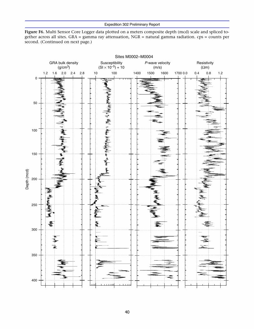
Downhole variations in density, P-wave velocity, and magnetic susceptibility high-light a number of prominent stratigraphic changes that exist at all sites and correlatewell with observed seismic reflectors. The stratigraphic similarities among the sites al-lowed a single composite section to be constructed (Fig. F6A, F6B).
Compositionally, the upper 220 m of sediment recovered from Lomonosov Ridge ispredominantly silty clay (lithologic Unit 1). In contrast to deep marine sediment se-

Expedition 302 Preliminary Report
quences, this interval does not exhibit a single, clearly defined consolidation patternwith depth. The upper ~20 mbsf shows first order increases in both density and ve-locity that appear to arise from normal consolidation processes (Fig. F7A, F7B).Throughout this upper unit, well-defined decimeter-scale variations in density, veloc-ity, and susceptibility occur in phase.
Between 70 and 100 mbsf, there is a shift away from the high-amplitude variation inmagnetic susceptibility that is a characteristic feature of the sediments below ~20mbsf. A subtle first-order reduction in the magnetic susceptibility of the sediments be-gins at 100 mbsf and continues to ~160 mbsf. This reduction may result from gradualcompositional changes occurring through this interval.
A noticeable decrease in all petrophysical properties measured on the multisensorcore logger (MSCL) occurs at ~166 mbsf and accompanies the transition from pre-dominantly olive-green sediments into those characterized by a more yellowish tobrown hue at the Unit 2/3 boundary. One of the most prominent changes is a largedecrease in P-wave velocity at ~198 mbsf, marking the transition into a biosiliceousunit. The upper part of this biosiliceous unit is largely composed of pyritized diatomsand is reflected in the petrophysical data as a low-velocity, high-density interval. At~220 mbsf, density decreases sharply from 1.7 to 1.3 g/cm3 without a noticeablechange in the P-wave velocity and is associated with the transition from a biosiliceoussilty clay unit into a biosiliceous ooze (Unit 2).
Large gaps in core recovery occur from ~220 to ~350 mbsf. An increase in densitythrough this interval could be the result of normal consolidation or a reduction in thebiosiliceous contribution to the matrix material. Below ~370 mbsf and the end of thepetrophysical record at ~410 mbsf, bulk density fluctuates between 1.6 and 2.1 g/cm3.Throughout this interval, large amounts of pyrite are found in the core catcher sam-ples. Peaks in susceptibility (>5 × 10⁻³ SI) and density (>3 g/cm3) indicate the presenceof dense material that is probably of diagenetic origin. The deepest cores recoveredfrom Hole M0004A, documenting the transition through sandstone and mudstonesand into basement, were too short and disturbed to be run on the MSCL.
Based on undrained shear strength measurements made on the ends of recovered coresections, the Lomonosov Ridge sediments have a low consolidation index (~0.1) (Fig.F8), suggesting underconsolidation with the exception of specific intervals. At ~55mbsf, a single measurement indicates a highly overconsolidated zone that overliesseemingly normally consolidated material. Below 155 mbsf, the consolidation ratio

Expedition 302 Preliminary Report
becomes slightly elevated and remains high until 193 mbsf where the resolution ofthe measurement device was suddenly exceeded.
In situ temperature was measured during coring operations using the British Geolog-ical Survey (BGS) and Adara temperature tools (Fig. F9). The mudline temperature wasrecorded on all runs and varied between tools. An attempt to normalize the in situmeasurements was made by using the average Adara determined mudline tempera-ture and adjusting all in situ measurements to this baseline value. The average gradi-ent calculated using all available data points is 43.2°C/km.
Significant features in the shipboard pore water chemistry profiles describe threegeochemical environments: shallow carbonate dissolution, deep sulfate reduction,and shallow ammonium oxidation (Fig. F10).
Lithologic and micropaleontogical descriptions of sediment note a general absence ofprimary carbonate below ~16 mbsf, where pH and alkalinity drop below 7.4 and 2.5,respectively. This means that pore waters near this depth are more corrosive to car-bonate tests than the overlying sediment or water column. Carbonate tests may havedissolved when they were buried to the depth of these corrosive pore waters.
High alkalinity below 200 mbsf suggests that chemical reactions are adding substan-tial amounts of HCO3
– at depth without accompanying H+. The likely candidate is sul-fate reduction of organic carbon:
2CH2O(s) + SO42–(aq) → 2HCO3
–(aq) + H2S(aq).
Black sediments (Unit 5) were rapidly deposited below 200 mbsf. These sedimentshost abundant pyrite and lie beneath dark banded intervals that may be composed ofother iron sulfide minerals. Organic matter in the black sediment probably reactedwith dissolved SO4
2– since the time of burial, producing abundant H2S and, ulti-mately, iron sulfide minerals.
A peak in alkalinity (at ~6 meters composite depth [mcd]) coincides with a sharpsteady rise in NH4
+. The peak in alkalinity supports the interpretation that some
Expedition 302 Preliminary Report
chemical reaction is producing HCO3– without accompanying H+. The NH4
+ profilefurther suggests that upward diffusing NH4
+ drives this reaction.
Sampling for microbiological analyses was conducted at fairly regular depth intervalsfrom the surface (7 mbsf) to near basement (398 mbsf) with a notable gap between169 and 241 mbsf. A total of 21 samples were preserved for enumeration of micro-organisms to provide estimates of subsurface biomass. Nineteen samples were storedanaerobically for the purpose of shore-based cultivation studies. A subset of samples(18) was stored at –51°C for DNA extraction and subsequent microbial communitycharacterization. Finally, 10 samples were stored at –51°C for lipid biomarker analysis.
$ &
- .$.
The Vidar Viking came under contract on Thursday, 22 July 2004, when mobilizationbegan in Aberdeen. By 26 July, all equipment for the Vidar Viking had arrived, includ-ing information technology equipment bound for the Oden, and the derrick was loadtested and certified. The Vidar Viking took on a full complement of fuel at Aberdeen.
/0 '.&
The Vidar Viking set sail for Landskrona, Sweden, on 28 July. While the ship was enroute, a first test of the drilling equipment was conducted in the Witch Ground areaof the North Sea, ~8 h steam from Aberdeen. A test borehole was drilled in 152 m wa-ter depth to a depth of 37 m using both the advanced piston corer (APC) and the ex-tended core barrel (XCB). Cores were obtained with both systems. The APC recovered>4 m in all runs (maximum = 4.5 m). The Vidar Viking left the test coring site at 1900h on 30 July and proceeded to Landskrona.
Meanwhile, the mobilization of the Oden proceeded at Gothenburg, which includedloading the laboratory equipment. On the evening of 31 July, the Oden set sail forTromsø, Norway.
Expedition 302 Preliminary Report
- .,!.+
The Vidar Viking reached Landskrona on the morning of 1 August. The stern notch, a100 ton section required by the Vidar Viking when working in ice, and the helideckwere installed. The remaining containers were loaded onto the deck, including thecore curation container sent from Bremen, Germany. Other mobilization work con-tinued until the morning of 3 August, when the Vidar Viking departed for Tromsø.
- . 1.&+
The Oden arrived in Tromsø on the evening of 5 August. The Vidar Viking arrived onthe morning of 7 August. Two helicopters, required for ice reconnaissance missions,landed on the Oden and were secured.
-# $2
Expedition 302 officially began when the Oden left Tromsø, Norway, at 2350 h on 7August 2004. The Vidar Viking remained in Tromsø for the next 12 h to wait for dy-namic positioning (Konsberg) spare parts to arrive.
Oden transited to 81°56′N, 44°59′E to meet the other two ships in the ACEX fleet, theSovetskiy Soyuz and Vidar Viking, at the edge of the polar ice pack on 10 August. Thefleet entered the ice together with the Sovetskiy Soyuz leading, the Oden following, andthe Vidar Viking bringing up the rear.
3
During the transit to the operational area, ice reconnaissance and personnel transferflights began on 12 August. The fleet made an unprecedented headway of 8–10 kt insea ice.
The fleet arrived on site at 2350 h on 13 August and began preparations for drillingand operations for maintaining position in the sea ice.
Preparations for drilling began with clearing ice from the moonpool. Once this wasdone, a steel skirt was deployed through and below the moonpool to protect the drillstring from ice impact. Once the ice protection skirt was in place, the drill floor andiron roughneck were installed. The drill floor was ready for operations by 0900 h on15 August.
Expedition 302 Preliminary Report
During this time, the fleet’s ability to maintain station was tested by positioning theSovetskiy Soyuz and the Oden upstream of the Vidar Viking. The initial stationkeepingtests were successful, and the Fleet Manager gave approval to start drilling operationsat 1100 h on 15 August.
Cores were recovered in five holes (M0002A, M0003A, M0004A, M0004B, andM0004C) (Tables T1, T2, T3). Hole M0001A was abandoned after a BHA was lost. Log-ging was attempted in two holes and data were collected over a 160 m interval in HoleM0004B.
Table T4 documents the allocation of time, broken down into (1) waiting for betterice conditions, (2) operational breakdown, and (3) drilling operations.
“Breakdown time” is defined as operational time consumed as a result of equipmentor mechanical failure. The loss of a BHA, for example, regardless if caused by humanerror or mechanical failure, necessitated a drill string trip. If the trip time is caused byequipment failures, it was considered as breakdown time “B.” Waiting for better iceconditions was labeled “W.” Similarly, if waiting on ice conditions required pullingpipe and subsequent preparations to begin drilling operations, these times were in-cluded in the “W” category because that time delay was caused by the “waiting forice” situation.
!"#$# %&! & '
We reached Site M0001 at 1100 h on 15 August. Later that day during drill string de-ployment, the high-pressure mud valve was damaged. The valve was removed, therest of the drill string was run, and then the broken valve was replaced. Pipe trips wereslowed or stopped intermittently to allow overheated hydraulic fluid in the new drillrig to cool.
By 16 August, the drill string was deployed to the seafloor and the first piston corerwas deployed at 0600 h. After pumping for 30 min, pressure was not obtained and thepiston corer was retrieved without having fired. Damaged seals on the piston corerwere replaced. Ice conditions were marginal, and at 0900 h operations were stoppedand the drill string was lifted from the seabed. Ice conditions improved by 1400 h,and operations continued. The piston corer was deployed again, and no pressure de-veloped in the drill string. Upon retrieval, the piston corer had not fired. It was sus-
Expedition 302 Preliminary Report
pected that the piston corer had not latched into the BHA. The XCB was thendeployed but was not recovered, which indicated that the BHA was lost. At 2000 h,the drill string was tripped and the BHA and XCB losses were confirmed.
Beginning early on 17 August, a new BHA was assembled and we began to lower thedrill string. When >800 m was deployed, the high-pressure mud valve on the swivelwas damaged again during pipe handling; we decided to trip the drill string becausethe operator did not want to risk leaving the drill string hanging in the water columnfor an unspecified period of time. After tripping pipe, the damage was assessed andOden’s chief engineer was tasked with manufacturing a new valve using materialsfrom a spare pup joint. As an interim solution, a conventional valve assembly was in-stalled.
Ice conditions deteriorated between 0900 and 2200 h, and the time was utilized tomove the Vidar Viking to a new position (Hole M0002A). Because there were no mudvalve spares, the Swedish Polar Research Secretariat (SPRS) began making arrange-ments for a Swedish Air Force C-130 airdrop of two new valve parts and one conven-tional valve assembly.
#"#() %*&! & '
Based on a strategy developed by the ice management team, the drill string was low-ered while drifting onto location. By 2200 h on 18 August, this strategy put the VidarViking within 190 m of the proposed site. The final positioning was done by icebreak-ing this short distance to Hole M0002A. Once on location at 0820 h, three more drillpipes were added and coring started. Because the mud valve was not yet repaired, theXCB was deployed instead of the APC. A first attempt at coring was unsuccessful, butafter adding more pipe and drilling another core run, some core was retrieved. Thefirst core on deck arrived at 1335 h at a water depth of 1209 m. Drilling operationscontinued throughout the afternoon. The newly fabricated mud valve from the Odenarrived late in the afternoon, and preparations were made for its installation during awireline trip. The temporary valve was replaced before more drill pipe was added forthe next core run. By midnight on 19 August, a depth of 31 mbsf had been reached.
Drilling and XCB coring continued until 23 August when the Fleet Manager orderedthe drill pipe to be pulled to 40 mbsf because ice conditions were deteriorating. Per-mission to continue drilling operations was given midday, and operations continueduntil 2100 h when the ice conditions forced the termination of Hole M0002A at adepth of 271.69 m.

Expedition 302 Preliminary Report
The drill string was tripped to the drill deck during the morning of 24 August. Afterwaiting for ice conditions to change in the afternoon, a transit began at 1930 h to aposition from which the Vidar Viking could drift onto location while tripping in drillstring.
While we waited on ice conditions and set up for the next site, an air gun seismic sur-vey was run from the Oden to tie Site M0002 to the next site (M0003).
+"#(#!%*&! & '
The Vidar Viking reached the ice-drift position at 2100 h and awaited ice reconnais-sance results. The iron roughneck, which had been removed to repair oil leaks, wasinstalled after repairs; the ice protector tube was lowered; and the drill floor was pre-pared. At 2300 h, the BHA and drill collars were run. At 0240 h on 25 August after 400m of pipe had been deployed, the housing of the iron roughneck cracked and had tobe removed for major repairs. Operations resumed at 1400 h using power tongs. Theseafloor was reached at ~2300 h, and at 0110 h on 26 August, the first APC core wasrecovered from Hole M0003A (Table T2).
A second APC core with a shattered liner was recovered. The third APC core becamestuck in the BHA. While trying to release the corer, the wireline parted at the mechan-ical termination, and it was necessary to pull the string. Hole M0003A was terminatedat 0440 h.
The ice management team conducted ice reconnaissance surveys, reviewed options,and recommended that the fleet move to a location farther west, where a longer-termprediction of relatively good ice could be made. Once the site was selected, the iceteam predicted an upstream ice position for the Vidar Viking to start to drift onto thenew location. The fleet steamed to the updrift ice position, arriving at 0630 h on 27August. During this time, wireline termination repair, APC service, and iron rough-neck the testing/refitting took place.
,"+ )-%./0+ ,-0%*&! & '
At 0755 h during pipe tripping, the high-pressure mud valve was damaged again. Thevalve was removed, and the remaining string was run to 1150 m depth while the valvewas repaired. At 1800 h, the Vidar Viking was on location (Hole M0004A). Once onstation, the repaired mud valve was installed and the drill string was run to the sea-bed. At 2230 h, drilling operations in Hole M0004A commenced and the hole was ad-vanced by washing ahead 17 mbsf (Table T3) before a piston corer was deployed.
Expedition 302 Preliminary Report
Shortly after midnight on 28 August, the APC became stuck in the BHA but was freedafter ~1 h. Once on deck, the plastic liner in the core barrel was found to be shatteredand 3.5 m of the core was stuck in the barrel. In light of these problems with the APC,in particular the risk of junking the hole again, it was decided to switch to XCB cor-ing. Two XCB cores were recovered to a depth of 30.5 mbsf followed by washing downto 265 mbsf using the insert bit. This decision to wash ahead was made in order torecover sediment deeper than that recovered in Hole M0002A. By 2240 h, a depth of265 mbsf was reached.
XCB coring operations continued for the next 3 days (29–31 August), where the holewas advanced at varying rates with good to poor recovery. During this time, the drill-ing was very slow (e.g., 1 m/h) and recovery in many cores was zero (Cores 302-M0004A-13X through 18X). Different strategies were tried to improve the advancerate. At times, the hole was advanced by washing ahead in an attempt to make fasterprogress but was ultimately abandoned after it was found that the washing rate wasalmost the same as the coring rate. On 31 August from 0200 to 0500 h, for two coringruns in a row, no core was recovered. The XCB shoe was switched to a coring shoe fora third attempt at recovery. This coring run cleared a blockage in the bit as the pumppressure dropped significantly. Following this core (with good recovery) and afterclearing the blocked bit, core recovery and advancement improved over the next 12h until basement was reached in Core 302-M0004A-35X. Basement penetration wasdifficult (8 m penetration in 12 h with low core recovery), and a decision was madeat 0900 on 1 September to stop coring at total depth of 428 mbsf and conduct loggingin Hole M0004A.
The logging tools were moved to the rig floor and the tool string (FMS-APS-NGT-SGT)and wireline rig-up proceeded simultaneously. The run into hole commenced at 2130h. This was done at low speed in order to allow the tools to warm up. Communicationwith the tool was established, and it was lowered to the end of the drill pipe. A com-puter malfunction caused a communication loss to the tools. The problem was cor-rected by 0200 h. The tool was powered up, and attempts were made to get the toolto pass through the BHA into the open hole. All efforts failed at the same depth(~1366 mbrf); so, while at rest at this depth, the calipers were opened on the FMS tocheck whether it was free or lodged. The calipers had some movement, which indi-cated that the tool string was free.
The landing ring for the core barrel is the narrowest section of the whole pipe string(95 mm) and lies ~6 m above the bit. All the logging tools had been checked through
Expedition 302 Preliminary Report
a landing ring dockside in Aberdeen, but there was no hole calibration ring onboardthat could be used as a second check. Sequentially, four more logging attempts weremade. Each time, it was assumed that the logging tools were too large in diameter andthe string diameter was further reduced by removing the larger diameter components.The APS bowspring was removed first, followed by the knuckle joint. Finally, only thenarrowest velocity-density string was deployed, which failed to clear the bit at thesame depth as the previous runs. After the fifth attempt failed, the logging time allo-cated had been used up and attempts to log Hole M0004A ended at 1045 h on 2 Sep-tember.
After the logging gear was cleared away and the drill string was lifted out of the sea-bed, preparations were made to start a second hole (M0004B) at the site. During prep-arations, the inner barrel was deployed but did not latch. After an improviseddownhole hammer was deployed and worked for 2 h, a short length of core (~10 cmof mudstone), which had been partially blocking the BHA, was recovered.
By 2030 h on 2 September, the Vidar Viking was at the new position for the next hole(M0004B). Coring in Hole M0004B started at a depth of 10 mbsf using the XCB be-cause the APC was deemed too risky. After retrieving the first sample, the hole waswashed to 20 mbsf for an in situ temperature measurement. The BGS temperatureprobe was lowered to the base of the hole, pushed into the sediment, and pro-grammed to record the temperature every 5 s. The probe was left to record tempera-ture for 40 min, after which it was retrieved. Plans to wash to a depth of 215 mbsf,core to 230 mbsf, and then wash to 250 mbsf and log were stymied by problems withdrilling pressure lines/gauges freezing at –10°C. Because of these problems and thelimited time left, the hole was only advanced to a depth of 220 mbsf. Temperaturemeasurements were made at 60 and 100 mbsf.
At 0000 h on 4 September, the pipe was pulled to 65 mbsf to prepare for logging. Rig-ging of the wireline and tool string occurred concurrently, and rig-up of both wascompleted by 0415 h. The tool string comprised the FMS-BHC-NGT-SGT; the choiceof tools was such that it could be run as a straight-through tool string without theneed for articulation and eccentralization subs. The logging string was run slowly tothe bit to warm the tools before powering them up. The logging string passed throughthe bit at 0530 h, and the first pass was completed at 0610 h. Logging operations werecompleted at 0710 h. Rig-down of the logging tool and wireline was completed by0905 h, and preparations began for a third hole (M0004C). Hole M0004C was spud-ded at 1200 h on 4 September, and the first APC core was recovered at 1420 h. Two

Expedition 302 Preliminary Report
more APC cores were recovered during the next 10 h. An attempt to make a temper-ature measurement at 9 mbsf using the Adara tool on the APC failed because of a deadbattery. At a depth of 14 mbsf, the APC core barrel became stuck after being fired. Theperiod from midnight to 0530 h on 5 September was spent trying to retrieve the pis-ton tool. Various attempts to recover the tool included flush only, hoist only, mixtureof flush and hoist, and hoist and leave at top of hoist for some time. The APC wasfreed and recovered by 0530 h, and the barrel was slightly bent (the liner was easilyremoved). Because of the risk of getting stuck again, coring continued using the XCBwith a modified Adara shoe to complete two more temperature measurements to adepth of 37 mbsf. Drilling operations ended at 1500 h. The drill string was retrievedby 0500 h on 6 September.
The Oden came alongside the Vidar Viking to transfer 400 T of fuel, and all three shipsof the fleet carried out required maintenance before the return transit. A seismic sur-vey was attempted from the Oden but was abandoned because of difficult ice condi-tions. The operational phase of the expedition ended, and the return transit began.
1%23 4.5
The convoy left the study area at 1930 h on 6 September and headed toward theNorth Pole. Progress was slow in the first half of the day but improved later, and thefleet arrived at the pole at ~2230 h. The convoy departed at 0100 h on 7 Septemberand made good progress toward Tromsø in almost continuous open water. The Odenarrived in Tromsø at 2300 h on Tuesday 13 September.
The Vidar Viking parted company with the Oden at the ice edge in the early hours ofSaturday, 11 September and headed due south. A crew change and demobilizationwere effected in Tanager, Norway, on 16 and 17 September. The Vidar Viking thensailed for Landskrona in Sweden, where the helideck was removed together with theEuropean Science Operator core and curation containers and the deep freeze samples.BGS/Seacore personnel continued the reconstruction of the deck, while vessel andshipyard personnel removed the moonpool and other expedition-linked items.
On 22 September, the Vidar Viking sailed for Aberdeen, Scotland, to complete the de-mobilization. Upon arrival in Aberdeen at 0800 h on 24 September, the remainder ofthe expedition equipment was demobilized and the vessel was cleared for her nextcharter by 2200 h that day. Formal end of charter, following tank cleaning and rein-statement and off-hire recertification, was completed on 25 September.

Expedition 302 Preliminary Report
$4&0,'&
We thank the Captains (Jørgen E Haave, Tomas Årnell, and Stanislav Smith) and thecrews of the Vidar Viking, Oden, and Sovetskiy Soyuz for skillfully helping us to accom-plish the first deep-sea drilling and coring in the central Arctic Ocean.
Expedition 302 Preliminary Report
3&
Aksu, A.E., Mudie, P.J., Macko, S.A., and de Vernal, A., 1998. Upper Cenozoic history of theLabrador Sea, Baffin Bay, and the Arctic Ocean: a paleoclimatic and paleoceanographicsummary. Paleoceanography, 5:519–538.
Backman, J., Jakobsson, M., Lovlie, R., Polyak, L., and Febo, L.A., 2004. Is the central ArcticOcean a sediment starved basin? Quat. Sci. Rev., 23:1435–1454.
Bukry, D., 1981. Silicoflagellate stratigraphy of offshore California and Baja California, DeepSea Drilling Project Leg 63. In Yeats, R.S., Haq, B.U., et al., Init. Repts. DSDP, 63: Washing-ton (U.S. Govt. Printing Office), 539–557.
Bukry, D., 1984. Paleogene paleoceanography of the Arctic Ocean is constrained by the mid-dle or late Eocene age of USGS Core Fl-422: evidence from silicoflagellates. Geology,12:199–201.
Clark, D.L., Whitman, R.R., Morgan, K.A., and Mackay, S.D., 1980. Stratigraphy and glacialmarine sediments of the Amerasian basin, central Arctic Ocean. Spec. Publ.—Geol. Soc.Am., 181:1–57.
Cronin, T.M., Holtz, T.R., and Whatley, R.P., 1994. Quaternary paleoceanography of the deepArctic Ocean based on quantitative analysis of Ostracoda. Mar. Geol., 19:305–332.
Gard, G., 1993. Late Quaternary coccoliths at the North Pole: evidence of ice-free conditionsand rapid sedimentation in the central Arctic Ocean. Geology, 21:227–230.
Grantz, A., Pease, V.L., Willard, D.A., Phillips, R.L., and Clark, D.L., 2001. Bedrock cores from89° north: implications for the geologic framework and Neogene paleoceanography ofLomonosov Ridge and a tie to the Barents shelf. Geol. Soc. Am. Bull., 113:1272–1281.
Heezen, B.C., and Ewing, M., 1961. The Mid-Oceanic Ridge and its extension through theArctic Basin. In Raasch, G. (Ed.), Geology of the Arctic: Torongo (Univ. Toronto Press), 622–642.
Ishman, S.E., Polyak, L.V., and Poore, R.Z., 1996. Expanded record of Quaternary oceano-graphic change: Amerasian Arctic Ocean. Geology, 24:139–142.
Jakobsson, M., Løvlie, R., Al-Hanbali, H., Arnold, E., Backman, J., and Mörth, M., 2000. Man-ganese and color cycles in Arctic Ocean sediments constrain Pleistocene chronology.Geology, 28:23–26.
Jakobsson, M., Løvlie, R., Arnold, E., Backman, J., Polyak, L., Knudsen, J.-O., and Musatov, E.,2001. Pleistocene stratigraphy and paleoenvironmental variation from Lomonosov Ridgesediments, central Arctic Ocean. Global Planet. Change, 31:1–22.
Jokat, W., Uenzelmann-Neben, G., Kristoffersen, Y., and Rasmussen, T.M., 1992. ARCTIC’91:Lomonosov Ridge—a double-sided continental margin. Geology, 20:887–890.
Kristoffersen, Y., 1990. Eurasian Basin. In Grantz, A., Johnson, L., and Sweeney, J.F. (Eds.), TheGeology of North America (Vol. L): The Arctic Ocean Region. Geol. Soc. Am., 365–378.
Ling, H.Y., 1985. Early Paleogene silicoflagellates and ebridians from the Arctic Ocean. Trans.Proc. Palaeontol. Soc. Jpn, NS, 138:79–93.
Matthiessen, J., Knies, J., Nowaczyk, N.R., and Stein, R., 2001. Late Quaternary dinoflagellatecyst stratigraphy at the Eurasian continental margin, Arctic Ocean: indications for Atlan-tic water inflow in the past 150,000 years. Global Planet. Change, 31:65–86.
Scott, D.B., Mudie, P.J., Baki, V., MacKinnon, K.D., and Cole, F.E., 1989. Biostratigraphy andlate Cenozoic paleoceanography of the Arctic Ocean: foraminiferal, lithostratigraphic,and isotopic evidence. Geol. Soc. Am. Bull., 101:260–277.
Thiede, J., Clark, D.L., and Herman, Y., 1990. Late Mesozoic and Cenozoic paleoceanographyof the northern polar oceans. In Grantz, A., Johnson, L., and Sweeney, J.F. (Eds.), The

Expedition 302 Preliminary Report
Geology of North America (Vol. L): The Arctic Ocean Region: Boulder (Geol. Soc. Am.), 427–458.Vogt, P.R., Taylor, P.T., Kovacs, L.C., and Johnson, G.L., 1979. Detailed aeromagnetic investigation
of the Arctic basin. J. Geophys. Res., 84:1071–1089.Wilson, J.T., 1963. Hypothesis of the Earth’s behaviour. Nature, 198:925–929.

Expedition 302 Preliminary Report
Table T1. Summary of core recovery.
Table T2. Type and number of cores recovered.
Note: APC = advanced piston corer, XCB = extended core barrel.
Table T3. Washed interval details.
Hole
Cored length
(m)
Core recovered
(m)
Core recovery
(%)
M0002A 271.69 213.15 78.5
M0003A 15.00 14.85 99.0
M0004A 157.59 78.41 49.8
M0004B 11.00 7.31 66.5
M0004C 40.19 25.34 63.1
Totals: 495.47 339.06 68.4
Hole APC XCB Wash
M0002A 0 62
M0003A 3 0
M0004A 1 41
M0004B 0 2 1
M0004C 4 5
Total number of cores: 8 110 1
Cored length (m): 37.07 455.40 3
Core recovered (m): 36.86 301.2 1
Core recovery (%): 99.4 66.1 33.3
Hole
Depth (mbsf) Washed interval (m)Top Base
M0004A 0.00 17.00 17.00
M0004A 30.50 265.00 234.50
M0004A 330.18 339.00 8.82
M0004A 345.60 355.60 10.00
Total: 270.32
M0004B 0 10 10
M0004B 15 212 197
Total: 207

Expedition 302 Preliminary Report
Table T4. Breakdown of operational time while on site during Expedition 302 (ACEX).
Notes: XCB = extended core barrel, BHA = bottom-hole assembly, APC = advanced piston corer. Approval was given to start running pipe on Site M0001at 1100 h on 15 August.
Date (2004)
Time (h)
CommentsT P D W B TR Total
15 Aug 8.50 2.50 2.00 13 Chicksan valve broken
16 Aug 6.00 5.00 13.00 24 XCB lost
17 Aug 24.00 24 BHA lost; chicksan valve broken
18 Aug 13.00 11.00 24 Repair of chicksan valve
19 Aug 9.58 14.42 24
20 Aug 22.83 1.17 24
21 Aug 15.83 8.17 24
22 Aug 24.00 24
23 Aug 10.00 14.00 24
24 Aug 9.50 1.00 10.00 3.50 24
25 Aug 10.67 1.00 1.00 11.33 24 Iron roughneck failed; reflective seismics (D)
26 Aug 3.50 4.25 16.25 24 Wireline termination failed
27 Aug 13.50 1.50 1.75 7.25 24 Chicksan valve broken third time
28 Aug 21.33 2.67 24 APC stuck
29 Aug 24.00 24
30 Aug 24.00 24
31 Aug 24.00 24
1 Sept 4.75 5.42 11.67 1.00 1.17 24
2 Sept 1.83 2.92 19.25 24 Logging failed, plugged bit
3 Sept 23.08 0.92 24
4 Sept 5.50 12.67 5.83 24 Equipment frozen
5 Sept 8.33 8.75 6.92 24 APC stuck in BHA
6 Sept 5.00 6.50 8.00 4.50 24 Maintenance of ships; reflective seismics (D)
Totals: 68.1 18.9 247.9 53.3 137.6 15.3 541
Percent. 12.6 3.5 45.8 9.8 25.4 2.8
Expedition 302 Preliminary Report
Figure F1. Map of the Arctic Ocean showing the location of the Arctic Coring Expedition (ACEX) studyarea on the Lomonosov Ridge. The insert is a small scale map showing the locations of ACEX 302 sites.
180°E 120°
120°W
60°
0°E
60°E
Expedition 302 P
reliminary R
eport
Figure F2. Reflection seismic profile of Lomonosov Ridge (AWI-91090) with locations of ACEX 302 coring sites. Multichannel seismic data aret. Hole M0004B is located ~60 m
00 1900 1700
from Jokat et al., 1992. Cores were not retrieved from Hole M0001A because the BHA (gray on figure) was losaway from Hole M0004A; Hole M0004C is located ~60 m away from Hole M0004B. SP = shotpoint.
3500 3300 3100 2900 2700 2500 2300 21
1.0
2.0
3.0
Shots
Two-
way
trav
eltim
e (s
)
SP range of potential sites (ca 45 km)
M0004A,B,C M0001A M0002A M0003A
Rec
ordi
ng G
ap

Expedition 302 Preliminary Report
Figure F3. Photograph taken from one of the ACEX helicopters of station-keeping operations. SovetskiySoyuz is shown at the top of the image breaking large ice floes, Oden is in the middle of the image crushingmid-sized ice floes, and Vidar Viking is in the lower section of the image maintaining station over the drillsite.
Expedition 302 Preliminary Report
Figure F4. Core recovery summary diagram for all ACEX holes. Black = recovered core, white = no recov-ery, and gray = washed intervals. Total recovery was 68.4%. Hole M0004B was logged.
400
350
300
250
200
150
100
50
0 1H 1X2X3X4X5X6X7X8X9X10X11X12X13X14X15X16X17X18X19X20X21X22X23X24X25X26X27X28X29X
31X32X33X34X35X36X37X38X
40X41X42X43X44X46X47X48X49X50X
52X53X54X55X56X57X58X
60X61X
1H2H3H
1H2X3X
4X5X6X7X8X9X10X11X12X13X
19X20X
23X
24X25X
27X28X29X30X31X32X33X34X35X36X37X38X39X
1X
2W3X
1H2H3H4H5X
7X8X9X
Dep
th (
mbs
f)
Cor
e
Rec
over
y
Cor
e
Rec
over
y
Cor
e
Rec
over
y
Cor
e
Rec
over
y
Cor
e
Rec
over
y
Cor
e
Rec
over
y
Com
posi
teR
ecov
ery
HoleM0001A
HoleM0002A
HoleM0003A
HoleM0004A
HoleM0004B
HoleM0004C
39X
6X
14X16X18X
21X
26X
41X42X
22X
30X
51X
62X
59X
Expedition 302 Preliminary Report
Figure F5. Lithostratigraphic column with age estimates of the Lomonosov Ridge sediments and base-ment. This is a compilation from all five boreholes. (Continued on next page.)
10YR 4/310YR 5/42.5Y 5/45YR 6/410YR 4/35Y 4/75Y 5/410YR 4/610YR 4/1
Description of lithology
Silty clay and silty mud with strong color banding including brown, yellowish brown, light olive brown, light reddish brown, gray, pale brown, light yellowish brown, dark brown, olive gray, olive, dark yellowish brown, and dark gray. Color banding ranges in thickness from 2 to 50 cm, generally with sharp contacts between them. Bioturbation is slight throughout the unit. Smear slide analysis indicates minor amounts of biogenic carbonate. Isolated pebbles (0.5 to 1.0 cm diameter) occur throughout the subunit. Total organic carbon content is less than 0.5 wt%.
Light olive-brown silty clay with olive-brown banding in upper part to dark brown and yellowish brown silty clay with centimeter-scale very dark gray mottling in lower part. Isolated pebbles and millimeter- to centimeter-scale sand lenses occur throughout. Total organic carbon content is less than 0.5 wt%. Drilling disturbance is common with slurry and flow-in within Sections 302-M0002A-3X-1 through 3X-4 and 4X1-1 through 4X-4.
2.5Y 5/410Y 4/42.5Y 5/410Y 4/42.5Y 5/410Y 4/410YR 4/310YR 5/4
Silty clay and silty mud with alternating olive, gray, olive-gray, olive-brown, dark gray, and light olive-brown color banding at scales ranging from decimeters to meters, sometimes with mottled contacts between them. Some intervals are characterized by centimeter-scale color banding. Millimeter- to centimeter-scale sand lenses and isolated pebbles occur throughout. Bioturbation is slight to moderate with occasional well-defined Chondrities burrows. Total organic carbon content is less than 0.5 wt%. Drilling disturbance in recovered cores is generally minor although intervals of moderate disturbance (biscuiting), slurry, and flow-in occur.
5Y 5/35Y 4/35Y 5/15Y 5/25Y 4/25Y 5/62.5Y 4/42.5Y N4/12.5Y N4/02.5Y 5/4
10YR 4/310YR 3/310YR 3/22.5Y 7/4
Silty clay with alternating dark brown, very dark grayish brown, and pale yellow coloring at scales of decimeters to meters. Millimeter- to centimeter-scale sand lenses and isolated pebbles occur throughout. Bioturbation is slight. Millimeter-scale dark gray microconcretions occur within isolated intervals. Total organic carbon content is less than 0.2 wt%.
Silty clay, varying in color from light-gray to gray and olive gray. In addition, “zebralike” centimeter-scale subhorizontal banding composed of gray, very dark gray, and black with sharp contacts between occur in cores 302-M0002A-45X and 46X. Bioturbation is slight except in the lower zebralike interval where it is absent. Millimeter- to centimeter-scale sand lenses and isolated pebbles occur throughout. The gray and olive gray layers contain pyrite concretions. Total organic carbon content is 0.75 to 1.0 wt%.
2.5Y N7/102.5Y N5/05Y 5/25Y 3/15Y 2.5/1
5Y 3/1
Very dark gray, firm, homogenous silty clay to clayey silt. Black millimeter-scale microconcretions occur in some intervals. Isolated pebbles occur throughout; one sandy lens is observed in Section 302-M0002A-46X-1. Based on XRD data, Subunit 1/6 is characterized by increased feldspar/quartz and kaolinite/aragonite ratios as well as the presence of pyrite. Smear slide analyses indicate that siliceous microfossils (diatoms, ebridians, and silicoflagellates) occur in minor amounts within this subunit. Total organic carbon content is 2 to 3 wt%. Moderate drilling disturbance (biscuiting) is common. The deepest core in this subunit is slurry.
5Y 3/1
Very dark gray mud-bearing biosiliceous ooze, submillimeter scale light and dark laminations throughout, occasionally exhibiting cross-bedding visible in both undisturbed intervals and within coherent biscuits. Little, if any, bioturbation is obvious. Isolated pebbles observed as deep as 302-M0002A-55X-4, 122 cm (239.34 mbsf). Smear slide analyses indicate that dominant components include biosiliceous matrix, and microfossils (abundant diatoms, common to rare ebridians, and silicoflagellates). Terrigenous components are minor. Unlike Units 1, 3, and 4, XRD data indicate that Unit 2 is characterized by the dominance of K-feldspar over plagioclase. Total organic carbon content is 2 to 3 wt%. Within recovered sections, drilling disturbance is highly variable, ranging from undisturbed to drilling slurry.
Color
Dep
th (
mbs
f)
Lith
olog
ic
unit/
subu
nit
Cor
es (
Hol
esM
0002
A–M
0004
A)
Rec
over
y (a
ll ho
les)
Lith
olog
y
Age
20
0
40
60
80
100
120
140
160
180
200
220
240
260
280
300
late
Ple
isto
cene
mid
dle
Mio
cene
-Ple
isto
cene
mid
dle
Mio
cene
-la
te M
ioce
nem
iddl
e E
ocen
e-m
iddl
e M
ioce
nem
id.
Mio
.m
iddl
e E
ocen
e
H?-L. Pleist.U1/1
U1/2
U1/3
U1/4
U1/5
U1/6
U2
2X
3X
4X
5X
6X
7X
8X
9X
10X
11X
12X
13X
14X
15X
16X
17X18X19X
20X
5X6X
7X
8X
9X
10X
11X
12X
13X14X
21X
22X
23X
24X
25X
26X
27X28X29X
31X32X
33X
34X
35X
36X37X38X39X40X
41X
42X
43X44X
46X47X48X
49X
50X
52X53X
54X
55X
56X
57X
58X59X60X
61X
30X
1X
45X
51X
62X
Expedition 302 Preliminary Report
Figure F5 (continued).
5Y 3/15Y 4/1 - 5Y 3/15Y 3/2
Sediments are very dark gray clay grading down-core into interbedded very dark gray and dark gray clay. This grades into dark olive-gray silty clay below Core 302-M0004A-31X. Submillimeter-scale laminations are present in Cores 302-M0004A-27X, 28X, 30X, 32X, and 35X. Slight bioturbation occurs in parts of Cores 302-M0004A-27X, 28X, 30X, 32X, and 35X. Pyrite nodules occur in Cores 302-M0004A-27X, 28X, 30X, 32X, and 35X. An anomalous yellowish brown (5Y 3/1, 5Y 3/2) layer occurs at 32X-CC, 5 to 10 cm. Smear slide analyses indicate that the dominant components in the clay and silty clay are, in increasing order, feldspar, pyrite, quartz, and clay. Accessory minerals include minor amounts of zircon. Total organic carbon content is 1 to 2 wt%. Drilling disturbance is moderate in Cores 302-M0004A-19X to 34X.
5Y 3/2
Loose coarse sand was recovered in Core 302-M0004A-39X-CC and was bagged at sea. Because the stratigraphic position of this sand cannot be constrained, Unit 4 begins at the top of Section 302-M0004A-41X. Sediments are composed of homogenous dark olive-gray clayey mud. A sandstone fragment (4 cm diameter) was recovered in the top of Section 302-M0004A-41X-1. Smear slide analysis indicates that Unit 4 is dominated by quartz, feldspar, and clay. XRD data indicate a feldspar/quartz ratio greater than 1. Total organic carbon content is 1 wt%.
Dep
th (
mbs
f)
320
340
360
380
400
420
late
Pal
eoce
ne-e
arly
Eoc
ene
late
Cre
tace
ous
Description of lithologyColorLith
olog
ic
unit/
subu
nit
Cor
es (
Hol
esM
0002
A–M
0004
A)
Rec
over
y (a
ll ho
les)
Lith
olog
y
Age
16X17X
19X20X21X
22X23X
24X
25X
27X28X29X30X31X
32X33X34X
35X
36X
37X
38X
39X40X
U3
U4 42X
15X
18X
26X
41X
Expedition 302 Preliminary Report
Figure F6. Multi Sensor Core Logger data plotted on a meters composite depth (mcd) scale and spliced to-gether across all sites. GRA = gamma ray attenuation, NGR = natural gamma radiation. cps = counts persecond. (Continued on next page.)
Sites M0002–M0004
0
50
100
150
200
250
300
350
400
Dep
th (
mcd
)
1.2 1.6 2.0 2.4 2.8
GRA bulk density(g/cm3)
10 100
Susceptibility(SI × 10–5) + 10
1400 1500 1600 1700
P-wave velocity(m/s)
0.0 0.4 0.8 1.2
Resistivity(Ωm)
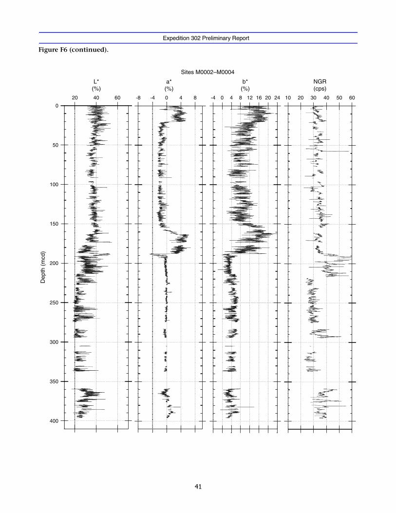
Expedition 302 Preliminary Report
Figure F6 (continued).
20 40 60 -8 -4 0 4 8
L*(%)
a*(%)
b*(%)
-4 0 4 8 12 16 20 24
NGR(cps)
10 20 30 40 50 60
Sites M0002–M0004
0
50
100
150
200
250
300
350
400
Dep
th (
mcd
)

Expedition 302 Preliminary Report
Figure F7. Multi Sensor Core Logger data for the upper 20 mcd showing all holes and the overlap achievedamong them. (Continued on next page.)
4C-1
4B-1
3A-1
3A-2
4A-1
4A-3
4C-2
2A-8
2A-5
2A-7
2A-6
2A-9
2A-12
2A-11
2A-10
2A-1
3A-3
4A-2
4C-3
4C-4
4C-5
2A-2
2A-3
Sites M0002, M0003, and M0004
0
10
20
30
40
50
1.2 1.6 2.0 2.4 2.8 3.2
GRA bulk density (g/cm3, + 0.2 g/cm3, …)
Dep
th (
mcd
)
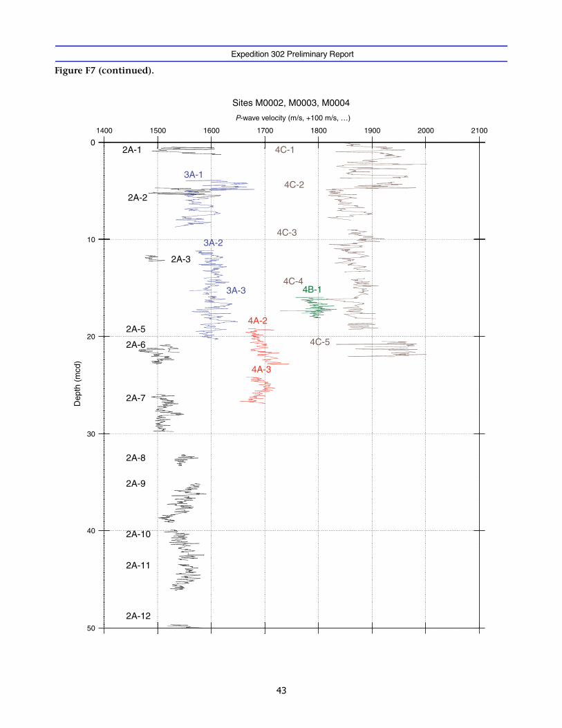
Expedition 302 Preliminary Report
Figure F7 (continued).
4C-1
4B-1
3A-1
3A-2
4A-3
4C-2
2A-8
2A-5
2A-7
2A-6
2A-9
2A-12
2A-11
2A-10
2A-1
3A-3
4A-2
4C-3
4C-4
4C-5
2A-2
2A-3
Sites M0002, M0003, M0004
0
10
20
30
40
50
1400 1500 1600 1700 1800 1900 2000 2100
Dep
th (
mcd
)
P-wave velocity (m/s, +100 m/s, …)
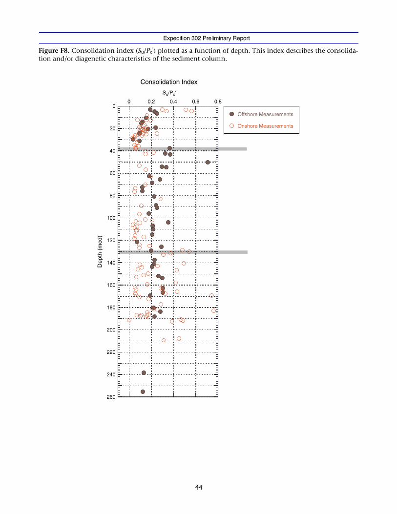
Expedition 302 Preliminary Report
Figure F8. Consolidation index (Su/Pc′) plotted as a function of depth. This index describes the consolida-
tion and/or diagenetic characteristics of the sediment column.
0
20
40
60
80
100
120
140
160
180
200
220
240
260
Consolidation Index
Offshore Measurements
Onshore Measurements
Su/Pc′
0 0.2 0.4 0.6 0.8D
epth
(m
cd)
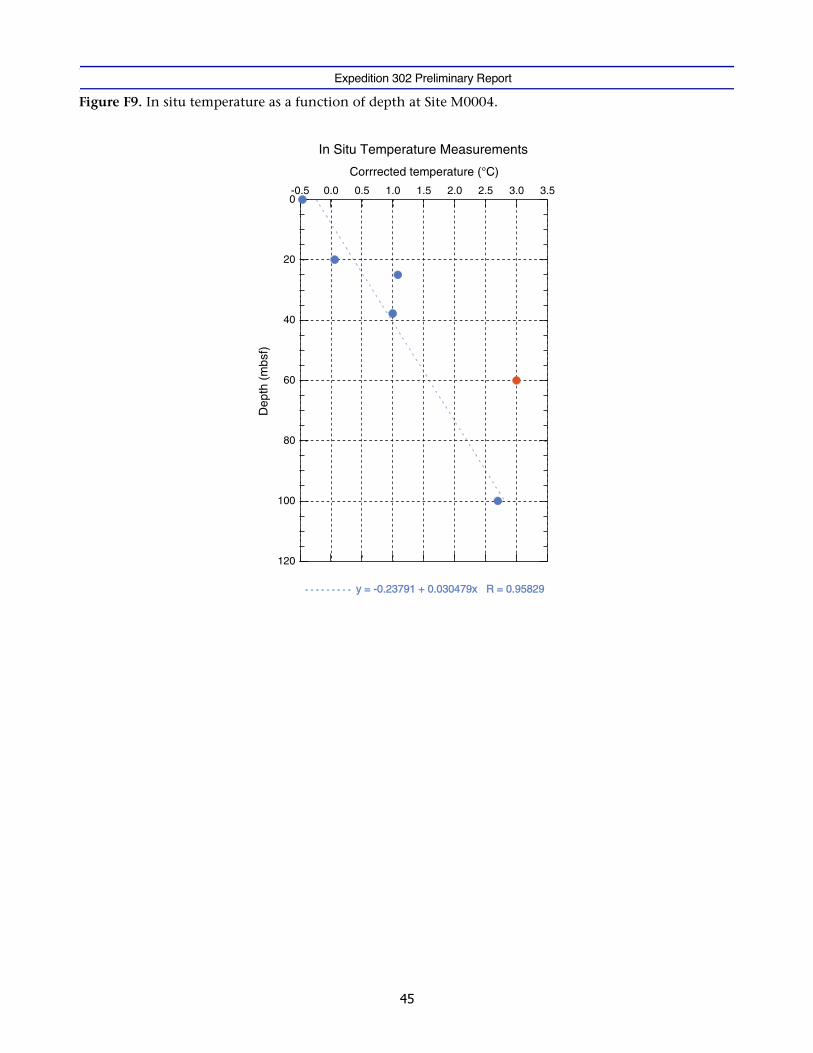
Expedition 302 Preliminary Report
Figure F9. In situ temperature as a function of depth at Site M0004.
0
20
40
60
80
100
120
In Situ Temperature Measurements
y = -0.23791 + 0.030479x R = 0.95829 y = -0.23791 + 0.030479x R = 0.95829
Corrrected temperature (°C)
Dep
th (
mbs
f)
0.0-0.5 0.5 1.0 1.5 2.0 2.5 3.0 3.5
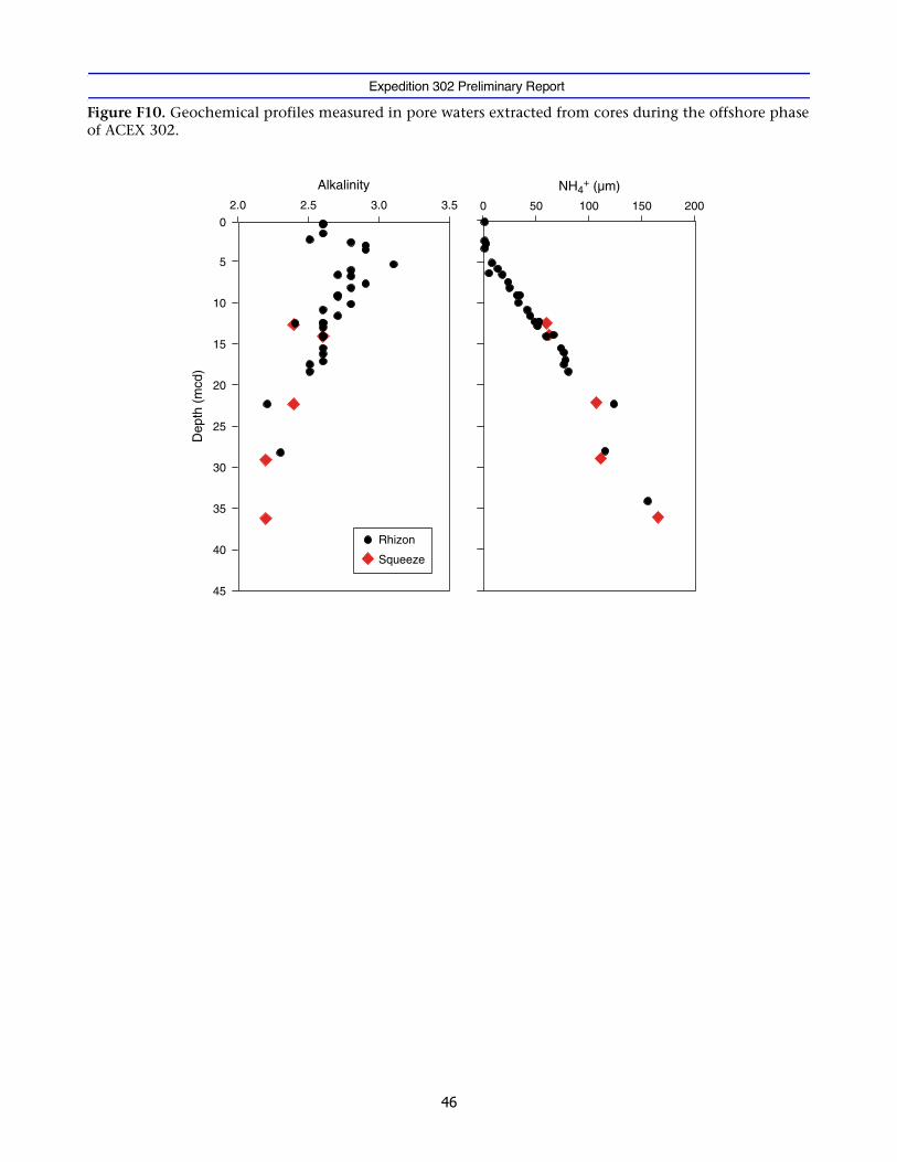
Expedition 302 Preliminary Report
Figure F10. Geochemical profiles measured in pore waters extracted from cores during the offshore phaseof ACEX 302.
0
5
10
15
20
25
30
35
40
45
2.0 2.5 3.0 3.5
Alkalinity
Squeeze
Rhizon
0 100 150 200
NH4+ (µm)
50D
epth
(m
cd)
![[XLS] · Web view1 302 2 302 3 302 4 302 5 302 6 363 7 363 8 302 9 302 10 307 11 302 12 302 13 223244 14 302 15 302 16 224 17 302 18 302 19 302 20 302 21 302 22 23 24 25 26 302 27](https://img.pdfslide.us/doc/110x75/5b00c3a37f8b9a952f8d6104/xls-view1-302-2-302-3-302-4-302-5-302-6-363-7-363-8-302-9-302-10-307-11-302-12.jpg)