Embed Size (px)
Citation preview
CAZRI Publication No. 39
INTEGRATED NATURAL AND HUMAN RESOURCES APPRAISAL
OF JAISALMER DISTRICT
Edited by
P.C. CHATTERJI & AMAL KAR
mw:JH9 ICAR
CENTRAL ARID ZONE RESEARCH INSTITUTE JODHPUR-342 003
1992
March 1992 CAZRI Publication No. 39
PUBLICA nON COMMITTEE
Dr. S. Kathju Dr. P.C. Pande Dr. M.S. Yadav Mr. R.K. Abichandani Dr. M.S. Khan Mr. A. Kar Mr. Gyanchand Dr. D.L. Vyas Mr. H.C. Pathak
Published by the Director
Chairman Member Member Member Member .Member Member Sr. A.D. Sr. F. & Ac.O.
Central Arid 20he Research In.Hitute, Jodhpur-342 003
* Printed by MIs Cheenu Enterprises, Navrang, B-35 Shastri Nagar, Jodhpur-342 003 , at Rajasthan Law Weekly Press, High Court Road, Jodhpur-342 001 Ph. 23023
Foreword-Preface A,cknowledgements Contributors Technical support Chapter I Introduction Chapter II Climatic features
CONTENTS
Chapter III Geological framework Chapter- IV Geomorphology ChapterY Soils and land use capability Chapter VI Vegetation Chapter VII Surface water Chapter Vill Hydrogeological conditions
Chapter IX Chapter X Chapter XI Chapter XII Chapter X III Chapter XLV
Minetal resources Present land use Socio-economic conditions Status of livestock Wild life and rodent pests Major Land Resources Units: Characteristics and asse%ment
Chapter XV Recommendations Appendix I List of villages in Pokaran and laisalmer Tehsils,
laisalmer district, alongwith Major Land Resources Units (MLRU)
Appendix II List of villages facing scarcity of drinking water in laisalmer district
Appendix III New site~ for development of Khadins in Iaisalmer
district Appendix IV Sites for construction of earthen check dams, anicuts
and gully control structures in laisalmer district Appendix V Natural resources of Sam Panchayat Samiti
CAZRI Publications Some other publications from CAZRI
( iii )
Page
iv v
vi vii
viii
5 12 14 26 35 42 50
57 58 62 67 73
76 87
105
119
]20
121 122
, .. 150 154
FOREWORD
The largest and driest district in the country-Jaisalmer, is endowed mainly with a sandy habitat. The region has very low potential for natural resources, resulting in low biological productivity. The system can not sustain the increasing biotic pressure. Inventory and appraisal of the basic resources is the first step towards an overall process of resource management of the region. This is why the emphasis is being laid on the detailed analysis of the existing and potential resources and formulation of scientific plans for their development and sustained productivity. A multidisciplinary team of scientists undertook this challenging task and came out with the present volume for undertaking the developmental programme, mostly in. the areas not to be covered by the Indira Gandhi Nahar Pariyojana Command. On request from the Desert Development Commissioner, Jodhpur, a detailed teport on the natural resources of the Sam Development Block has been prepared and appended. Moreover, as per the guidelines provided by our Honourable Prime Minister to carry out district-wise planning, it is hoped that this report will be of immense value to the district development authorities.
September 29, 1989
(I.P. ABROL) Deputy Director G~neral
(Soils, Agronomy, Engineering & Agroforestry) Indian Council of Agricultural Research
New Delhi
( iv )

PREFACE
laisalmer district, located in the extremely hot arid part of India, is now on the verge of change. Although its productio~ P9tentials in terms of agriculture are extremely poor due to its inherent climatic and other constraints, the gradual introduction of the Indira Gandhi Canal network within the district will lead to fast changes in not only its agrarian situation, but also in other related spheres of activities, including the socio-economic set-up. However, the history of irrigated agriculture in the deserts of the world point to the fact that limited water use, alongwith a better understanding of the facets of the land and its problems, are of utmost necessity for sustained agricutural growth under such circumstancess. Moreover, even under the extremely arid situation there are certain useful plants in the district which can sttain climax state under slight range care, and help maintaining, not only the equilibrium of the fragile terrain, but also the ecologically sustainable livestock population of the region. The crucial factor for consideration before choosing the options is, therefore, an inventory of the resources of the district, both biotic and abiotic. Since unplanned growth of human and livestock populations in the extremely fragile environment of the district are leading to acceleration of the problems in many areas, the studies on the natural, human and animal resources, their dynamism and their interrelations will also help in suggesting the appropriate methods and sites for development, as well as control measures. The data base will also help in monitoring aad evaluating tq.e changes that are currently taking place. The Institute, therefore, carried out a multi-disciplinary survey on the natural, human and animal resources of the district during 1982-86, under the able guidance of the then Directors.
The data from survey were analysed and mapped disciplinewise and then integrated, on the basis of which specific recommendations were formulated. The report contains the salient findings of that survey, alongwith small scale maps. Detailed report on each discipline, alongwith detailed maps, could be had from the concerned disciplines on request.
It is hoped that the report will be helpful in formulating the plans for development in the district.
( v )
(J. Venkateswarlu) Director
ACKNOWLEDGEMENTS
It would have been impossible to bring out this report on the "Integrated Natural and Human Resources Appraisal of Jaisalmer District" in time, without fhe active support and cooperation of several organisations and individuals. We would like to place on record our sincere thanks for all of them.
We express our sincere gratitude and thanks to Dr. J. Venkateswarlu, Director, CAZRI, for his keen interest, constant guidance and encouragement in brining out this report in time.
The Collector and District Magistrate, Jaisalmer, very kindly arranged to supply the land revenue data and the village maps of the tehsils, for which we express our sincere thanks to him. Information on ground water potential zones has been collected from the published reports of Rajasthan Ground Water Department (Government of Rajasthan), while the geological information is based on the reports of Geological Survey of India. The sources are thankfully acknowledged.
Draft and final typing of the various discipline reports and the present edited report were ungrudgingly carried out by the following secretarial staff members: Mrs. Sreedevi Mohanan, Shri Pukh Raj, Shri Nar Singh Ram, Shri C. D. Manoharan, Miss Kamla Bheel, Mrs. Aleyamma Varghese, Shri K.N. Murali, Mrs. Bhavani Bhaskaran, Shri Harish Dharwani and Mrs. Marykutty Thomas. We extend our sincere thanks to all of them for their help .
• Without the active support and cooperation of the Administra tive, Stores, Accounts, and Automobile Workshop staff members the project could not have been completed in time. This is thankfully acknowledged.
The services rendered by the following Drivers made it possible to complete the survey work in time: Shri Kistoor Singh, Shri Virendra Singh, Shri Girdhari lal,
Shri Barrsi Lal, Shri Bhanwar Singh and Shri Rang Lal. Moreover the following supporting grade staff membl;!r provided imrnense help in field as well as in laboratory: Shri Basti Ram, Shri Nek Mohammad, Shri Narain Lal, Shri Keshu Lal, Shri Roop Singh,' Shri Dharma Ram, Shri lila Ram, Shri Dana Ram, Late Shri Luna Ram, Shri Nathu Ram, Shri Suresh Kumar, Shri Guru Dayal and Shri Narendra Singh. We express our sincere thanks to all of them.
Last of all, we thank Shri Sujan Singh Solanki for reproducing the pages of text and figures, of this report a task which he carried out with great care.
VI
P.C. Chatterji Amal Kar
CONTRIBUTORS
Division of Wind Power and Solar Energy Utilization
1. Climatic features
Division of Basic Resources Studies
2. Geological framework and hydrogeological conditions
3. Geomorphology
4. Soils and land use capability
5. Vegetation
6. Surface water
7. Present land use
8. Coordination of Basic Resources Survey
Division of Human Factor Studies
9. Socio-economic conditions
Division of Animal Studies
10. Status of livestock
I I. Wild life and rodent pests
Compilation and editing of report and integrated analysis
(vii)
Y.S. Rama Krishna A.S. Rao R.S. Singh
P.C. Chatterji J.C. Dubey (for report writing only) B. Ghose (1982-83) Amal Kar A.S. Kolarkar Nepal Singh Vi nod Shankar Suresh Kumar N.S. Vangani K.N.K. Murthy Shri A.K. Sen Gheesa Lal
K.A. Shankaranarayan (Upto December, 1983) 8. Ghose (Dec. 1983 to March, 1985) R P. Dbir (April 1985 to Dec. 1986)
L.P. Bharara C.S.K. Johory
P.K. Ghosh H.C. Bohra-Tshwar Prakash (Professor of Eminence) P.C. Chatterji Amal Kar
TECHNICAL SUPPORT
Division of Wind Power and Solar Energy Utilization
1. R.S. Purohit
Division of Basic Resources Studies
2. M.L. Sharma 3. D.V. Ramanaiah (UplO July, 1984) 4. Ranjeet Singh Purohit 5. Sujan Singh Solanki 6. Mukesh Sharma (From April, 1986) 7. Ganga Ram 8. D.S. Kaith 9. S.P. Seth
10. P.C. Bohra ]1. Idan Ram ]2. N.S. Bhati 13. Kundan Lal 14. Basha Ram 15. Teja Ram 16. Abhay Singh 17. D.N. Bohra 18. V.C. Issac 19. A.K. Kalla
Division of Human Factor Studie8
20. Wajid Khan 21. Virendra Kumar
Final drawing of maps and figures aud map reproduction
22. S.S. Dave '23. P.K.Joshi. 24. Bajrang Lal 25. Ashok Gehlot
26. R.C. Bissa 27. A.K.Ojha 28. A.R. Malakar
29·. B.L. Tak 30. Vijendra Kumar 31. Deva Ram
32. Kanhiya Lal
viii
CHAPTER I
INTRODUCTION
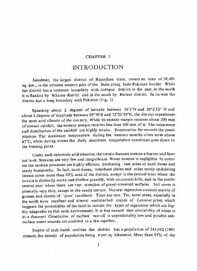
Jaisalmer, the largest district of Rajasthan state, covers an area of 38,401 sq. km., in the extreme western part of the State along Indo-Pakistan border. While tbe district bas a common boundary with Jodhpur district in the east, in the north it is flanked by Bikaner district and in tbe south by Barmer district. In its west the district bas a long boundary with Pakistan (Fig. I).
Spanning about 2 degrees of latitude between 26°I'N and 28°2'12" Nand about 3 degrees of longitude between 69°30'E and n020'30'E, the district experiences the most arid climate of the country. While its eastern margin receives about 200 mm of annual rainfall, the western margin receives less than 100 mm of it. The occurrence and distribution of the rainfall are highly erratic. Evaporation far exceeds the precipitation. The maximum temperature during the summer months often sores above 47°C, while during winter the daily minimum temperature sometimes goes down to
the freezing point.
Under such extremely arid situation the terrain features assume a barren and faceted look. Streams are very few and insignificant. Water erosion is negligible. In contrast the aeolian processes are highly efficient, producing vast areas of sand dunes and sandy hummocks. In fact, sand dunes, interdune plains and other sandy undulating terrain cover more than 60% area of the district, except in the central tract where the terrain is distinctly rocky and shallow gravelly, with occa~ional hills, and in the southcentral part where there are vast stretches of gravel-strewned surfaces. Soil cover is generally very thin, except in the sandy terrain. Natural vegetation consists mainly of grasses and shrubs of 'poor' condition. Trees are rare. Yet,- some areas, especially in the north have excellent and almost undisturbed stands of Lasiurus grass, which suggests the potentiality of the land to sustain the types of vegetation which are highly adaptable to this xeric environment. It is but natural that availability of water is at a discount. Generation of surface run-off is unpredictably low and potable subsurface water sources are confined to a few aquifers.
Inspite of such harsh realities the district has a population of 243,082 (1981
census), the density of population being 6 per sq. kilometre. More than 85% of the
7" CI
s
0' 7Cf 0'0
Fig, I,
2
JAISALMER DISTRICT LOCATION MAP
I(M. 10 0 10 20 30 40 K",,,
,.
u
28 0'
27· O·
2 CAZRr JODHPUR 1989 O'
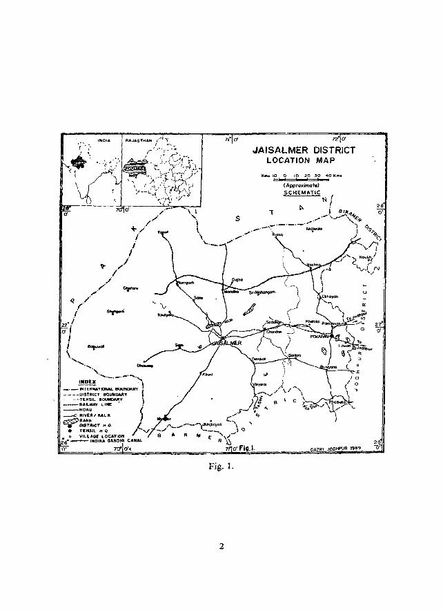
total population is rural, inhabiting 515 villages under two tehsils, namely Jaisalmer and Pokaran (Fig. 2; Appendix I). Only 36.3% of the total population is considered as workers, engaged as cultivators (18.77%), agricultural labourers (1.07%), household manufacturers (O.83%)! other workers (11.42''/0, especially as livestock rearers) and marginal workers (4.22%). The rest 63.69% population is considered as non' workers
(1981 census).
The low percentage of cultivators and agricultural labourers in the district is due to the severe environmental constraints for agricultural operation. Much of the land is not fit for agriculture, because of climatic, terrain and soil constraints. Yet, over the centuries people have evolved a system of moisture and rainwater conservation for agriculture, locally known as Khadill. Animal husbandry is practised on a large scale, due to the capability of much of the land to sustain grasslands alone. According to the 1983 livestock census the district harbours 1.6 million heads of
livestock, mainly consisting of sheep and goats.
Since the environment is highly fragile and the resources are scarce and mostly in degraded state, introduction of any technology for development within the district should be preceded by an inventory of all its resources, both biotic and abiotic, and careful analysis of relationship between the resources, the state of their exploitation, the key problems and problem areas and the expected changes in the resources under induced conditions. To fulfill these objectives a multi-disciplinary resources survey was carried out by the Central Arid Zone Research Institute, Jodhpur, during 1982-85. The presevt report summarises the findings, supplemented by small-scale resources maps, and highlights the resource patterns, the problems and the recommended
practices.
Additionally, the resource potentials and problems of Sam Panchayat Samiti, occupying the westernmost part of the district, have been highlighted in an appendix. The Samiti is in the extremely arid part of the district and has a sparse population. Much of the terrain is still in a less disturbed state, but in some parts activities connected with Indira Gandhi Canal have just started. The present data base will not only help in monitoring the changes brought about by these activities, but will also belp
in fixing the priorities for development.
3
Ii:> .~- --ll~~------T<ro'----'~------.. ~1~
.L :), I! .L S, (J
n d H (J o ,.
4
CHAPTER II
CLIMATIC FEATURES
a) General climatic characteristics
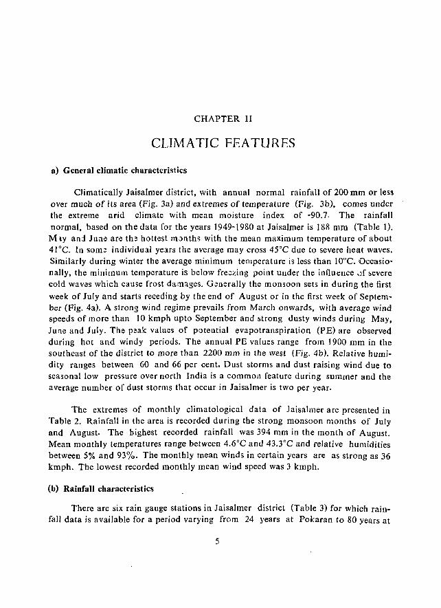
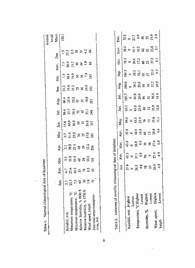
Climatically Jaisalmer district, with annual normal rainfall of 200 mm or less over much of its area (Fig. 3a) and extremes of temperature (Fig. 3b), comes under the extreme arid climate with mean moisture index of -90.7. The rainfall normal, based on the data for the years 1949-1980 at Jaisalmer is 188 mm (Table 1).
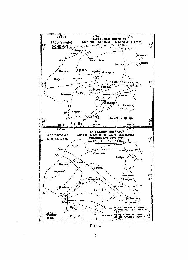
M_lY anl June are th~ hottest m:>nths with the mean maximum temperature of about 41°C. In some individual years the average may cross 45°C due to severe heat waves. Similarly during winter the average minimum temperature is less than 10°C. Occasionally, the minimum temperature is below freezing point under the influence ~f severe cold waves which cause frost damages. Generally the monsoon sets in during the first week of July and starts receding by the end of August or in the first week of September (Fig. 4a). A strong wind regime prevails from March onwards, with average wind speeds of more than 10 kmph up to September and strong dusty winds during May, June and July. The peak values of potential evapotranspiration (PE) are observed during hot and windy periods. The annual PE values range from 1900 mm in the southeast of the district to more than 2200 mm in the west (Fig. 4b). Relative humidity ranges between 60 and 66 per cent. Dust storms and dust raising wind due to seasonal low pressure over north India is a common feature during summer and the average number of dust storms that occur in Jaisalmer is two per year.
The extremes of monthly climatological data of laisalmer are presented in Table 2. Rainfall in the area is recorded during the strong monsoon months of July and August. The highest recorded rainfall was 394 mm in the month of August. Mean monthly temperatures range between 4.6°C and 43.3°C and relative humidities between 5% and 93%. The monthly mean winds in certain years are as strong as 36 kmph. The lowest recorded monthly mean wind speed was 3 kmph.
(b) Rainfall characteristics
There are six rain gauge stations in Jaisalmer district (Table 3) for which rainfall data is available for a period varying from 24 years at Pokaran to 80 years at
5
(Approximate)
(Approximate) SCHEMATIC
7i O' 7Z O' JAI SALYER DI5TRICT
ANNUAL NORMAL RAINFALL (mm)
7 oIAISALWER DISTRICT
MEAN MAXIMUM AND MINIMUM TEMPERATURES ,·e)
'tonot \. KN4~~:~~:~=~:~·....-t-),,_o . 4~-O
~_..; --- --- -..... ... ,_,I'"\ ,_ S~~~h~ I
- ' I .... Hoehna r y: \ '
--- ...... . " Mondh'a"
"-"- ,
"
• ,..J ~o ..... _l ..
I )
I '- .. 1. 0
\.... '-
amdoJo • I
Poko!an ')
/42-0 __ r
'" 5-0 ) /
27 0'
o·
27 O'
MEAN MAXiMUM TEMP. DURiNG HOTT[ST MONTH (HAY) N
Flg.3b
Fig. 3.
6
70° dE (Approximate)
S CHE M_ATlC
Fig. 4.
7
27 0'
N
.... u E -;; '" .~ _, .... o cO -:; -0
-;; u ·60 o "0 -:; .s u -; E ... o Z
..: o Z
ti o
c:: cO .....
00 00
8
u o
00
~o
0"<1; 0\ .... N
.0 u II.> 0-
'" -0": '" 0-
~~
OJ '-a 0 '" 0 "? 0\ M 0 ... 0 0 M I.Ci ,...: ~O .... ('I . '"
a a co co 0\ 00 0 $ 00 _:~ '" ~ 1.0 1.0 00 1.0
0\ 0\ ~ ~ ~ - '" >< .... ~ a: '" 0 ·iii ...J ...
§8 ~ 0 0 0 0 0 0 ;::l
~a 0 N 0 ,...: g; .,.; '" N "<!"
'" co '0
~
'" ._~ '" 0 ...... ..... 00 N E °a M 00 00 00
'" ~ ... «l ""'"
N M N N ... o 0 ';( s::: W
-v; u co "'" ...... ...... ::0 \C 1.0 ..c .,
""'" ..... ...... M
.!:!' >< '" 0\ 0\ 0\ 0\ 0\ ;r: .... ..... .... .....
~ §a 0 00 "! ~ C! ...; ..of ,...: .... M
""'" 65 00 00 ..,. .... 1.0 \0
:c ..... .,... "<t '" M ""'" co ~ ·c
co > !!J .... ,
'" co
"" ·a·S ~ ..... c IE ";:.2 "'" N N 0\ 0 co or) ...; ,...: c::i 00 0 "0 ~ 0- \0 ...... 1.0 0\ "<t 1.0
:s u '" :a Q .... "E.2 a Q 00 00 ...... ...... ~ '" ...; ,...:
~ ,...: ...; 00
E .g ~ 5 ('I 0\ :!; 00 0\
to c·_ co > '" .......
·iii II')"'=' -. .s ._ ~ 0 ... '" u
.@ ,.c >. til ~ ..... "<t \0 t-: ..... .... Bc>. N I.Ci ,...: 00 ...... 00 ., ::s ._ os ...... a Z ~"'=' ~ ';(
~-::::E '" .... ~ "<!" ...... ~ \0 ." a~~ 00 M ,...: c::i ;:::: ..of c 00 ..... ..... 1.0 oS .... C c E ...... N o c._ to zoSe ::s c c co c .. .,
:::E .... -= '"
..c ... s::: ..; .... !Jb c a co e " .2 to co -= co ..c
.:0 -;; '" 5 2 E -" -" oS .(;j oS .. co 0 0
Eo-< en ... ~ U. In 0.. Z
9
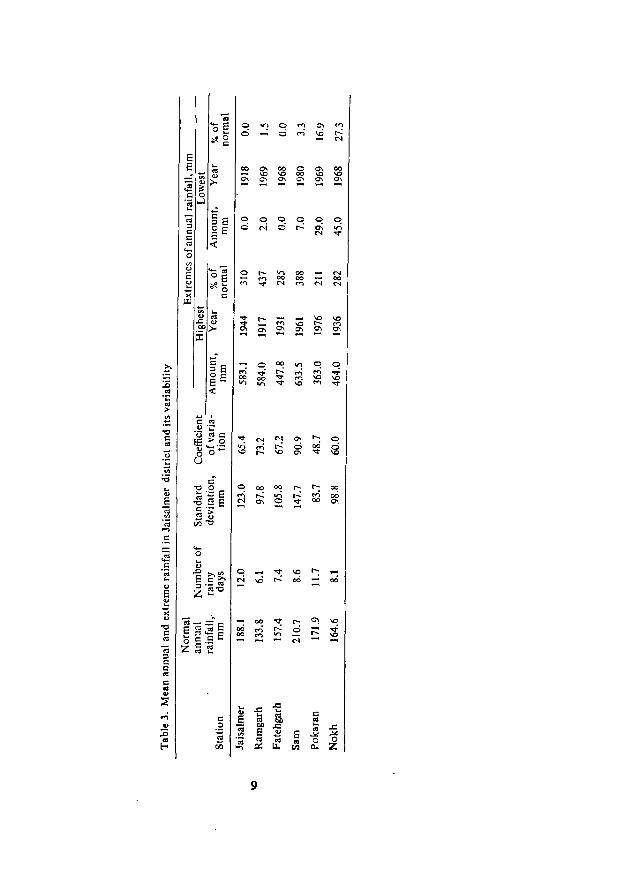
laisalmer and Ramgarh. The bulk of the annual rainfall at these stations are received during luly, August and September months and the highest at most of the stations occurs generally in the month of August. The annual rainfall varies from 134 mm at Ramgarh to 21l mm at Sam and the total number of rainy days varies between 6 (Ramgarh) and 12 (Jaisalmer and Pokaran). Winter rainfall is very uncommon in the district.
The coefficient of annual rainfall varies from 49 per cent at Pokaran to 91 per cent at Sam. Most of the stations in the district have annual rainfall with a coefficient of variation above 60 per cent. The highest recorded annLlal rainfall was from 363 mm at Pokaran to 634 mm at Sam.
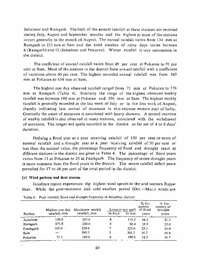
The highest one day observed rainfall ranged from 71 mm at :Pokaran to 178 mm at Ramgarh (Table 4). Similarly the range of the highest observed weekly rainfall was between 190 mm at Pokaran and 396 mm at Sam. The highest weekly rainfall is generally recorded in the last week of July or in the first week of August, thereby indicating late arrival of monsoon in this extreme western part of rndia. Generally the onset of monsoon is associated with heavy showers. A second maxima of weekly rainfall is also observed at many stations, associated with th::: withdrawal of monsoon. The longer wet spells recorded in the district so far are of 4 to 8 days' duration.
Defining a flood year as a year receiving rainfall of 150 per cent or more of normal rainfall and a drought year as a year receiving rainfall of 50 per cent or less than the normal value, the percentage frequency of flood and drought years at different stations in the district are given in Table 4. The percentage of flood years varies from 13 at Pokaran to 23 at Fatehgarh. The frequency of severe drought years is more common than the flood years in the district. The severe rainfall deficit years prevailed for 17 to 46 per cent of the total period in the district.
(c) Wind pattern and dust storms
. laisalmer region experiences th.e highest wind speeds in the arid western Rajasthan. While the post-monsoon and cold weather period (Oct.-Mar.) winds are
Table 4. Peak rainfall, flood and drought frequency in Jaisalmer district
% fre- % fre-quency quencyof
Highest one day Maximum weekly Longest wet spell of flood drought Station rainfaJJ, mm rainfall, mm in days inmm years years
Jaisalmer 130.0 267.6 8 111.5 16.3 21.3 Ramgarh 177.8 228.6 6 88.0 18.9 23.0 Fatehgarh 165.0 259.0 7 223.6 23.1 25.0 Sam 3Q5.7 5 395.7 16.7 45.8
Pokaran 71.1 189.6 6 189.0 12.5 16.7
10

generally light and variable (5 to 11 kmph), winds normally build up from April and continue to remain strong till the end of September. Peak wind speeds are observed in June which records a mean monthly wind speed of 27.2 kmph. The maximum daily wind velocity in the area frequently reaches 30·45 kmph during June and July, with peak winds of upto 100 kmph during severe dust storm period. The wind in the area is predominantly from the north east or northerly direction in winter, while during the rest of the year it is mostly south-westerlies to west-south-westerlies. These high winds during April to September favour formation of dust storms. Interestingly the average frequency of dust storms in the region \s the lowest (2 per year) in the western Rajasthan, but during severe drought years upto 15 dust storms are recorded.
(d) Agroclimatic features
The mean annual rainfall within Jaisalmer district varies from 130 mm to 210 mm, with a crop growing season of about 4 to 6 weeks only and, therefore, the region is not suitable for crop production. The growing season available for pastures is 8 to 10 weeks under normal conditions of rainfall and the grasslands are SUbjected to drought conditions once in four years during the growing phase, a[fectint:; the forage production. The forage production in good rainfall years (7.96 million metric tons) is three times more than the production under normal rainfall conditions (2.66 million metric tons). During severe drought years, the forage production decreases drastically (by about 86%), compared to the production during a normal year.
The crop production under rainfed conditions in the distric[ is confined mainly to the south eastern part where the mean annual rainfall is around 200 mm. The pearl millet is grown under 80 per cent of the net Sown area in the district, inspite of poor yields and regular crop failures. The average yield is 113 kg/ha. with a coefficient of variation of 89 per cent in the yield. Rainfall is inadequate even for sowing in 20 to 30 per cent of the years.
The percentage frequency of occurrence of agricultural drought in Jaisalmer district varies from 4% of the period under early commencement of sowing rains, 18% under normal and 78% under late commencement of sowing rains. With late commencement of sowing rains, the area under pearlmillet decreases from 128 to 97 thousand ha and the grain yield from 128 to 99 kg/ha. The percentage probabilities for occurrence of agricultural drought is very high (about 88%).
11
CHAPTER III
GEOLOGICAL FRAMEWORK
The different geological formations within the district range from pre-Cambrian to Quaternary in age. The major part of the district is covered with wind blown sand (Recent) in the form of dunes which attain considerable height in the north-west. There are series of ridges and rocky plateau around laisalmer and in the southern part there are granite hillocks near Khora Kunda. Near Pokaran and Gomat there are hills of Jodhpur sandstone.
On the basis of exposed rock formations and subsurface data the sedimentary sequences of Jaisalmer district could be classified into four major basins, viz. laisalmer basin, Lathi basin, Birmania basin and Nagaur basin.
The Mesozoic sequences comprising of Jaisalmer formation, Parewar formation and Abur formation (Cretaceous), and the Cenozoic sequences, comprising of Sanu formation (Eocene), were laid down in the main Jaisalmer basin.
The fresh water sandstones, siltstones and conglomerates, belonging to Lathi formation, were deposited in the Lathi basin. A small Birmania basin towards the south of Jaisalmer includes Randha Sandstone and Birmania Limestone (Cambrian) which are equivalent to Jodbpur Sandstone and Bilara Limestone of Nagaur basin.
The periphery of Nagaur basin commences near Pokaran where Pokaran boulder beds rest over Malani rhyolites. The Jodhpur Sandstone, overlying Pokaran boulder beds, form a few outcrops near Pokaran and to its south. A cap of Bap boulder bed, with, underlying marine Bhadaura Saruistone (Permocarboniferous), overlie the sedimentary sequences of Nagaur basin.
The generalised stratigraphic sequence of different rock formations of Jaisalmer district is as follows:
Quaternary
Cenozoic
Recent
Sub-recent
............ major Eocene
12
Wind blown sand younger alluvium Older alluvium Shumar grits unconformity ............ . Bandah Limestone
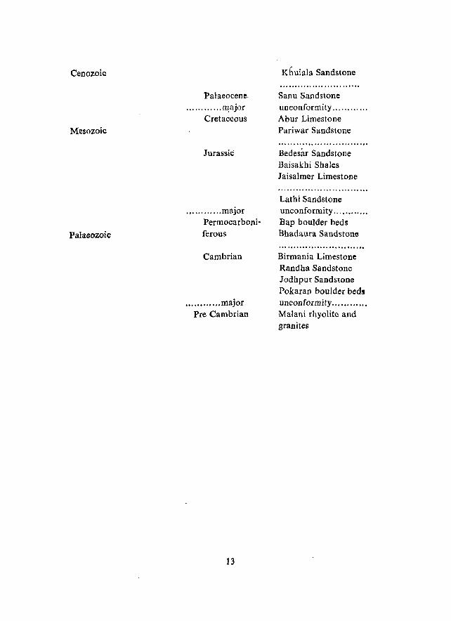
Cenozoic
M~sozoic
Palaeozoic
Palaeocene ......... ".II!ajor
Cretaceous
JurassiC
............ major Permocarboniferous
Cambrian
............ major Pre Cambrian
13
Khuiala Sandstone
Sanu Sandstone unconformity .......... .. Abur Limestone Pari war Sandstone
Bedesar Sandstone Baisakhi Shales Jaisalmer Limestone
Lathi Sandstone unconformity ........... . Bap boulder beds Bhadaura Sandstone
Birmania Limestone Randha Sandstone Jodhpur Sandstone Pokaran boulder beds unconformity ......... '" Malani rhyolite and granites
CHAPTER-IV
GEOMORPHOLOGY
Iaisalmer district, because of its location in the extremely arid part ot: the Indian desert, has terrain features which are distinctly arid in nature, with areas of either dominantly sandy forms or the barren rocky-gravelly forms, punctuated with areas of shallow in situ/transported depositional forms. Because of extreme paucity of rainfall, high insolation and higher wind speed the land forming processes are dominantly aeolian. Effects of fluvial processes are negligible, although the dry valleys in the central rocky part bear testimony to the efficacy of the spasmodic discharge during rare cloud-bursts. In the central rocky part the Tertiary and preTertiary continental to marine sedimentary beds are al&o acted upon by numerous ground level weathering processes, although the effects of dominant aeolian processes are noticed in the typical modifications to the rock fragments.
Because of such climatic and terrain features the streams are very few, ephemeral in nature and confined mostly to the rocky part. The most notable among these are the Lik, showing its appearance from a low rhyolite hill range near Bhaniyana and flowing southwards; the Sukri, having its distinct course from near Pokaran and flowing westward; another Sukri, originating from near Sankra and flowing northwestward to meet the other Sukri; the Ramgarh nala, originating from near Ramgarh and flowing north\\-ards; and the Vikharan nai, originating from near Khuiyala and flowing northwestward. The streams hardly record any flow, have gravelly or coarse sandy bed, except in the case of the Lik which has slightly finer sandy alluvium along its course, and are either truncated .by sand dunes or are desiccated by aridity. Broadly the area between Pokaran-Mohangarh-Ramgarh-Sam-Fatehgarh- Rajmathai-Lawan is dominantly rocky-gravelly, while the area beyond is dominantly sandy with different types of sand dunes. The sandy forms, consisting of the dunes, interdunal plains and other undulating plains, cover the largest area of 23, 305.0 sq.km (or 60.68% of the total area). Other depositional plains cover 11,715.4 sq.km area (30.52% of the total area), of which oniy 6,94.2 sq. km (1.81%) area is under alluvial plains and the rest is shallow, associated with rocky/gravelly units. The exposed rocky/gravelly surfaces cover 3380.6 sq.km area (8.8% of the total area).
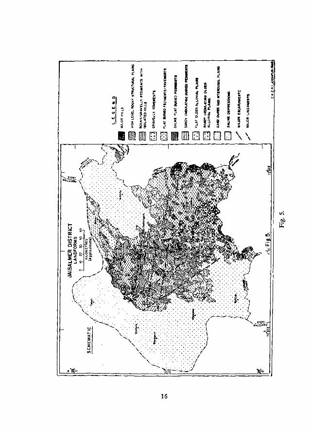
There are eleven major land form units within the district (Table 5; Fig. 5) their location, characteristics and potentials are as follows.
14
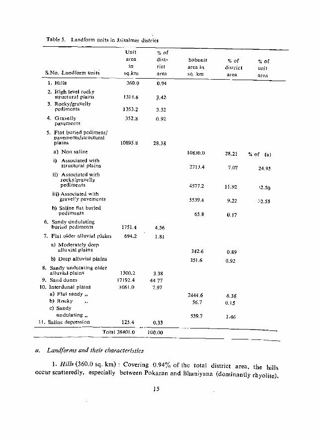
Table 5. Landform units in Jaisalmer district
Unit % of area dist- Subunit % of % of
in rict area in district Unit S.No. ,Landform units sq.km area sq km area area
I. Hills 360.0 0.94
2. High level rocky structural plains 1314.6 ;3.42
3. Rocky/gravelly pediments 1353.2 3.52
4. Gravelly 352.8 0.92 pavements
5. Flat buried pediment/ pavements / str uctural plains 10895.8 28.38
a) Non saline 10830.0 28.21 % of (a) i) Associated with
structural pIa ins 2713.4 7.07 24.95 ii) Associated with
TOcky!gravelly pediments 4577.2 11.92 \2.50
iii) Associated with gravelly pavements 5539.4 9.22 ~'2.55
b) Saline flat buried pediments 65.8 0.17
6. Sandy undulating buried pediments 1751.4 4.56
7. Flat older alluvial plains 694.2 1.81
a) Moderately deep aUu vial plains 342.6 0.89
b) Deep alluvial plains 351.6 0.92 8. Sandy undulating older
alluvial plains 1300.2 3.38 9. Sand dunes 17192.4 4477
10. Interdunal plains 3061.0 7.97 a) Flat sandy" 2444.6 6.36 b) Rocky 56.7 0.15 c) Sandy
undulating" 559.7 ].46 11. Saline depression 125.4 0.33
Total 38401.0 100.00
a. Landforms and their characteristics
1. Hills (360.0 sq. km) : Covering 0.94% of the total district area, the hills occur scatteredly, especially between Pokaran and Bbaniyana (dominantly rhyolite),
15
~ .. .. ~ -' i .. j • ~ ~ .. t ...
~ I z .. .. ~ ~ .. <II .. ,_ a .. ... '" 0 It w n ... ,.. !!!
Z '" --' .. N is ~ u -' .... .. ... on i
.. __ ... H, Co ~ j --'
'" ... gD ~ W it i' ~ ~ ... ~~ __
.. .. ~ ~ " ~ ~ ..J 15'" ... .. '" ,,~ '" .. ,. i' .. on
I ~ IDlll [] [ill] II . . I
«~)}~i t'~.: I~f
., ...... _ t o •••• ,
~#./..tt,~--" •. ~ \ ... ", . • / .... " '). .......... f (.~: > ......... <.... \. I
.!~." '.
z·~b
16
Ii VI
I ~ .. • i <! @ g ~ Q ~ ! 5 ..
! Il .. !a :> Q
~ __
;t .... !f '" i~ I ...
z a ~a . ::> -' ~ 0
i~ ,. 0
~ j z .. ...... ..
"> ..... .. [ill 0 fill 0 . . .
u
I .. • '" .. l .. .. "' If .. ! liI
'" I "' ~ ~
c .. " [] . \
.. .. a .. :I -« .. z :;
'" ~ .. ,. , \.
._ ~
I It.
i 0; N ..

around Randha and Lakhan (mainly granite), and betwe~n Ramgarh-Joga Kanod line in the north and Sam-Shipal-Rama-Rasla line in the south (sandstone and limestone). Hills formed or capped by sandstone are mainly in the form of mesas and buttes, while the limestone bills provide a low rounded profile. The rhyolite and granite hills stand out as· inselbergs and domal inselbergs. Some of the hills, especially between Thayat, Mohangarh, Danwar and Damodara are in the form of cuestas and hog backs because of a slight northwestward tilt of the rock beds. The hills are barren and almost devoid of lengthy talus slope. In the south the slopes of many isolated hills between Chhatangarh, Devra and Bhopa have been partly covered by sand dunes.
2. High level rocky structural plains or !tarnadas (J 3 14.6 sq. km) : Over much of the rocky terrain the Tertiary and pre-Tertiary beds of sandstone, limestone and shale with their typical near-horizontal or gently dipping disposition, have been sculpted into high level rocky structural plains (or the hamadas), bounded by steep escarpments where the softer beds underneath are exposed. In the case of slightly tilted beds the hamadas appear like broad cuestas with steep southeast facing escarpments and gentler 1° to 5° dip slope northwestward. A number of minor drainage lines originate along the dip slope, maintain their courses on the rocky hamada and die out after a certain distance beyond. The Kankni and the Masurdi near Jaisalmer and the Sam Nadi near Khuiyala are the best examples. The surface is generally rocky throughout (e.g. around Pokaran 011 Jodhpur Sandstone, around laisalmer on Jaisalmer Limestone and near Mokal on Bedesar Sandstone), but where the siliceous bouldery Khuiyala limestone forms the parent rock, especially between Khuiyala, Habur, Sanu, Joga and Biprasar, it provides a much rougher surface. Similarly the gritty layers of Sanu Sandstone and the fossiliferous Bandah Limestone do also provide some roughness.
The usual landform sequence from the escarpment towards the dip slope is a cuesta or a hogback (rarely), followed by a narrow serir plain where ephemeral channels from the cuesta's dip slope converge, and then a broadly convex hamada, the continuation of which is broken by another escarpment.
3. Rocky/gravelly pediments (1353.2 sq. km): The isolated hills and the escarpment side of some hamadas are flanked by rocky/gravelly rediments. The unit covers 3.52% of the total area and occurs widely in Damodara-Kinoi-Habur-Mokal·ChhatreI area and in Sam-Nibh Dungar- Khuri-Bida area where sandstone and limestone are the chief constituents. In the south and east these have been formed on rhyolite and granite. Because of insufficient moisture and run-off, the processes of weathering and erosion are very limited and hence angular and blocky rock fragmen ts, many of them ventifacted or varnished, abound the surface. At places the surface has scattered distribution of polished sandstone balls and smaller nodules, produced by the long
17
period of physico-chemical weathering and wind-assMed rolls. The slope seldom
exceeds 1° of inclination within this unit.
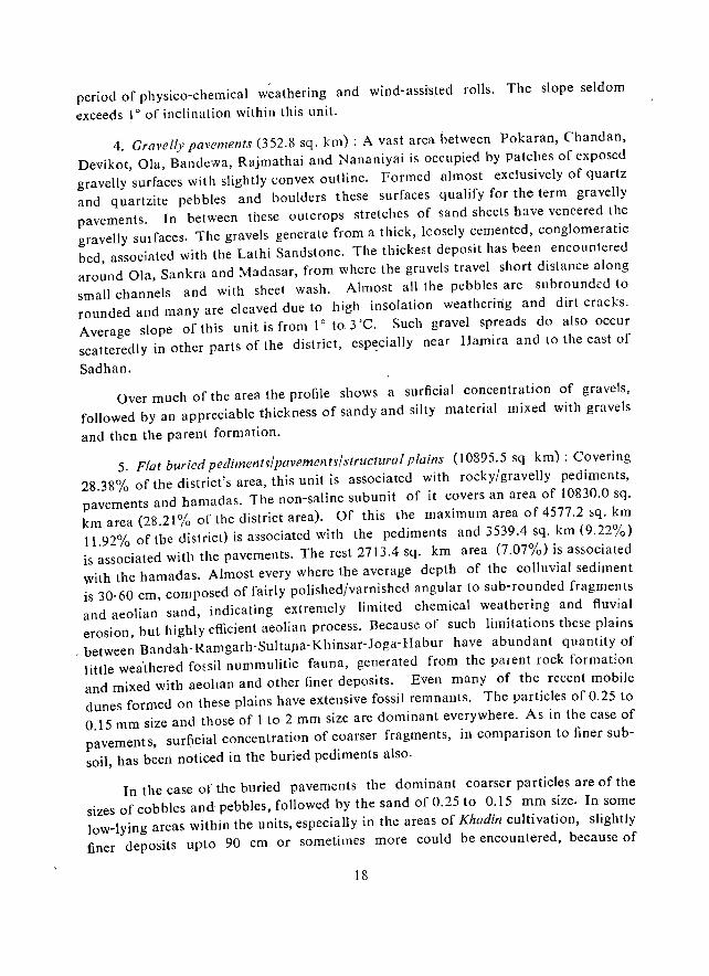
4. Gravelly pavements (352.8 sq. km) : A vast area between Pokaran, Chandan, Devikot, Ola, Bandcwa, Rajmathai and Nananiyai is occupied by patches of exposed gravelly surfaces with slightly convex outline. Formed almost exclusively of quartz and quartzite pebbles and boulders these surfaces qualify for the term gravelly pavements. In between these outcrops stretches of sand sheets have veneered the gravelly surfaces. The gravels generate from a thick, loosely cemented, conglomeratic bcd, associated with the Lathi Sandstone. The thickest deposit has been encountered around Ola, Sankra and Madasar, from where the gravels travel short distance along small channels and with sheet wash. Almost all the pebbles are subrounded to rounded and many are cleaved due to high insolation weathering and dirt cracks. Average slope of this unit is from 10 to 3'C. Such gravel spreads do also occur scatteredly in other parts of the district, espt:cially near Hamira and to the east of
Sadhan.
Over much of the area the profile shows a surficial concentration of gravels,
followed by an appreciable thickness of sandy and silty material mixed with gravels
and then the parent formation.
5. Flat buried pediments/pavements/structural plains (10895.5 sq km): Covering 28.38% of the district's area, this unit is associated with rocky/gravelly pediments, pavements and hamadas. The non-saline subunit of it covers an area of 10830.0 sq. km area (28.21 % of the district area). Of this the maximum area of 4577.2 sq. km 11.92% of the district) is associated with the pediments and 3539.4 sq. km (9.22%) is associated with the pavements. The rest 2713.4 sq. km area (7.07%) is associated with the hamadas. Almost every where the average depth of the colluvial sediment is 30·60 em, composed of fairly polished/varnished angular to sub-rounded fragments and aeolian sand, indicating extremely limited chemical weathering and fluvial erosion, but highly efficient aeolian process. Because of such limitations these plains
. between Bandah-Ramgarh-Sultapa-Khinsar-Joga-Habur have abundant quantity of little weathered fmsil nummulitic fauna, generated from the parent rock formation and mixed with aeohan and other finer deposits. Even many of the recent mobile dunes formed on these plains have extensive fossil remnants. The particles of 0.25 to 0.15 mm size and those of 1 to 2 mm size are dominant everywhere. As in the case of pavements, surficial concentration of coarser fragments, in comparison to finer sub
soil, has been noticed in the buried pediments also.
In the case of the buried pavements the dominant coarser particles are of the
sizes of cobbles and pebbles, followed by the sand of 0.25 to 0.15 mm size. In some low-lying areas within the units, especially in the areas of Khadin cultivation, slightly finer deposits upto 90 em or sometimes more could be encountered, because of
18
centripetal drainage and associated inflow of sediments. The average slope varies
from 0° to 1°.
The mappable area of saline flat buried pediments (65.8 sq. km) occurs amidst hills and pediment's around Modha and Sir\\a to the west of Devikot, where the salinity is principally due to the exposure of a salt-releasing bed of the Fatehgarh Sandstone and waterlogging. The surface is strewned with rock fragments, but has 30 to 40 cm thick finer deposit below, partly formed in situ from the siltstone bed
of ~he formation. Inspite of the hazard, Khadin cultivation is tried ill this unit.
6. Sandy undulating buried pediments (1751.4 sq. km) : Around the margins of the rocky desert and also within it low mobile barchans and other small sand ridges and hummocks create an undulating topography with shallow aeolian deposits in the swells (4.56% of district's area). Within the rocky area this unit occurs mainly along the dry channels and in areas of topographical low. In most cases the aeolian sand is followed at depth by rock. Chief occurrences are around Pokaran, Ujlan, Chacha, Bhairwa and to the north and west of Sultana-Ramgarh-Bandah line.
7. Flat older alluvial plains (694.2 sq. km): This unit occurs mainly along the dry bed of the Sukri through Ramdeora, Odhaniya and Chandni, along the Lik to the
south of Bhaniyana, in the north between Bahia and Brahmanwala Tibba, and also between Odhaniyu and Nananiyai. The unit has been further subdivided into moderately deep and deep. In the case of the moderately deep subunit the sediment thickness varies between 60 and 90 em, has layered deposits of medium to fine sand and coarse pebbles, and is followed by a riverine conglomeratic sequence at depth. Along the Lik the unit is affected by slight salinity-alkalinity hazard, because of the saline formation within the alluvium. The deep subunit is more than 90 cm deep, occurs mainly along the Lik south of Dantal and has the problem of salinity/alkalinity. The slope varies
from 0° to 1°. While the former subunit covers 342.6 sq.km (0.89%) area, the latter subunit covers 35L.6 sq.km (0.92%) area.
8. Sandy undulating older alluvial plains (1300.2 sq.km): Covering 3.38% of the total district area, this unit occurs mainly in the south eastern part and to the east of BahIa in the north, where sandy hummocks and ridges of 2 to 5 m height and sand sheets have covered the alluvial plains. The slope is irregular and varip.s from 10 to 3°. In the southeast the area is relatively well vegetated with trees and is regularly cultivated, but the hummocks in the north are highly unstable, less vegetated (by grasses only) and create more problems under slight biotic pressure.
9. Sand dunes (17192.4)·: The sand dunes cover the maximum area of the district (44.74%) and occur mainly in the north, west and southwest. In the east they have relatively scattered distribution. There are seven major types of sand dunes (Fig. 6), of which five are relatively stable, but are reactivated to various degrees. These are the
19
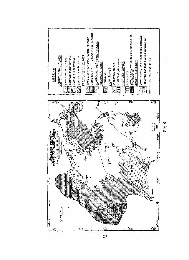
20
longitudinal, transverse, parabolic, star (fern leaf pattern) and complex (reticulate and longitudinal pattern superimposed on transverse) dunes with heights of 10 to 60 m. Among the dune fields (encompassing the sand dunes and interdunal plains) the longitudinal covers the maximum area of 110626 sq.km, followed·by transverse (4058.0 sq. km.), parabolic (3437.5 sq.km), complex (1495.9 sq km) and star (199.4 sq. km).
The most notable feature of the longitudinal dunefields is the changing shape of the dune from west to east. While in the west most of them are unattached feathered and maintain singularity unless joined by similar form along same trend line, in the east they change gradually from feathered longitudinals to the inverted Y-junctured ones where two or m),e sh)rt 101gitujinlls are noticed at the upwind end of a longitudinal and then 5 to 8 longitudinals converging at an acute angle without much downwind prolongation (i.e. beginning of the transitional zone to parabolics).
The majority of the mobile dunes are either the simple barchanoids of 8 to 10 m height, the isolated barchans of 2 to 8 m height and other minor sand streaks of 2 to 6 m height, which are of shifting nature and have been included in the sandy undulating units, or the compound megabarchanoids (980.0 sq. km) of 15 to 40 m height. While in the case of stable dunes the sand grains are predominantly of 0.15 to 0.125 mm size, in the case of the mobile dunes and reactivated crest of the stable dunes the dominant size is 0.25 to 0.1 R mm. Bimodality of sand is a chara-::teristic feature of the stable complex transverse dunes in the northwest.
10. Interdunal plains (3061.0 sq.km): Within the duny areas there are some large, mappable interdunal plains. Of these the flat sandy subunit Covers 2444.6 sq.km (6.36%) area, the sandy undulating one 559.7 sq. km (1.46%) and the rocky subunit 56.7 sq.km. (0.1. 5%) area. The shape of the interdunal plains is guided by the orientation of the dunes. Th.e fiat interdunes in the transverse dunefield of the northwest (e.g. Tanot-Kishangarh area) have dist:nctly fine.loamy texture with more of silt frac
tion, but elsewhere these interdunes have variable thickness of loose aeolian sand. In the west, especially in Tanot-Ghotaru-Shahgarh-Babuwali tract the dunes and interdunes are copiously vegetated with shrubs and grasses, because of the former courses of Saraswati through the area. The rocky interdunal plains occur mainly in the northeast, while the sandy undulating ones are scatterdly distributed. To the east and north of Mohangarh the interdunes are floored at many places by a gypsiferous hard layer at 60 cm to 150 em depth. Sand grains of 0.15 mm to 0.125 mm are dominant everywhere.
11. Saline depressions (125.4 sq. km) : These 'ranns' occur scatterdly within the rocky part, especially at Lawan, Pokaran, Ujlan, That and between laisalmer and Mohangarh, covering 0.33% area of the district. All the ranns are fed by minor
21
channels, are flooded after heavy cloud bursts and had outlets formerly, which are now chocked by sand. The Lik had its origin in the ranns of That and Ujlan, while the ranns between Jaisall1lcr and Mohangarh had an outlet northwards. The surface of the ranns is flat and hard when dry.
h. Assessment of natllral hazards and their effects
Because of extreme paucity of rainfall and high wind energy the domimlllt hazard within the district is of aeolian deposition, affecting 31153.5 sq. krn area (81.13% of total area), especially in the sandy tract and along the margins of the rocky tract (Fig. 7). The hazard is of severe proportion mainly around the settlements and in the southwest. The inter-dunal areas are generally affected by slight or moderate wind depositional hazard. Slight water erosional hazard is present in only 348.7 sq.km (091%) area, especially in the pavemented southcentral part, and the salinity! alkalinity has affected 108.2 sq.km (0.54%) area, through encrustation mainly in and around the ranns. Thus 6690.6 sq. km (17.42 % of the total) area is left with no apparent hazard, especially in the central rocky area and in parts of the flat older alluvial plains, yet it is mostly steriie.
Due to such constraints imposed by the climatic and terrain characteristics agriculture is hazardous in most parts of the district. In many parts there is a dearth of effective soil depth, while at others ploughing, especially through tractors, results in moderate to high reactivation of the sandy layer.
Deep ploughing of some cultivated fields through tractors (e.g. at Loharki and Ramdevra) and 'uprooting of the natural grasses from the sandy plains (e.g. at Chandan) resulted in a loss of 10 to J 5 em thick top soil in a single year {I 985) and created aeolian problems downwind. The formation and movement of barchans along well developed lanes of vortices and their transformation into longitudinal dunes, or the formation of barchanoid crest of the reactivated longitudinal dunes and their advancement through a series of growth seq uences have implications for trafficability in the region of such dune formation. The terrain in the sandy tract or the rocky margin is so fragile that slight disturbance to the system leads to sand reactivation'and slight unevenness becomes the focii of sand deposition during the high wind regime of the summer months. The surroundings of the settlements are, therefore, severely affected by mobile dune forms, leading in some cases to vast fields of barchanoids (e.g. Lunar).
The gradual introduction of the Indira Gandhi Canal into the district's northern part through Madasar, Nachna and Mohangarh will create better environment for agriculture in the interdune plains of the area. However, the earth work connected with canal construction has already created immense problem of reactivation of erstwhile stable dunes and threatened the roads, canal networks and settlements. Severe erosion
22
" 28'
N 26' 0'
o
'to" 0 E
SCHEMATIC
':;.W;"'fi1_G~~ -J
, j
0'1 II
0'
27 O'
7~ UIIII1 MODERATE TO SEVERE WIND DEPOSITION
~_ NO APPARENT HAZARD "D" SEVERE TO VERY SEVERE E::::'l : WIND DEPOSITION
2 0'
~ SLIGHT TO MODERATE SHEET Ttl r:;::"1 SLIGHT TO MOCERATE SALINITY-!2ill RILL EROSION ~ ALKALINITY
~ SLIGHT TO r.iODERATE RILL TO ['i""i""i('11.10DEII-iITE TO SEVERE SALINITY-~ GULlY EROSION ~ ALKALINITY
r:=::=::=l SLlGH1 TO MOPEflATF WIND ( •••••• 1 SEVERE TO VERY SEVERE l::::=3 DEPOSITION • •• SALINITY-ALKALINITY
~~¥ .. ~~~~~nd~Q~'~~~~~~~~~~::F'~-'~7~71~joO~· "====~_~~~A~~~R~I.~JO~O~"~PC~·r.~<~19~B&e~~~12~a~E~~~~~
Fig_ 7.
23
of the canal bank exposed to the dominant SW wind is also a major problem during the summer months. Away from the canal digging activities the dunes have remained
much less affected. Another major source for acceleration of the aeolian hazard in the canal command area is devegetalion of the dunes and interdunes for bringing more land under irrigated agriculture. Without the assured supply of water such dt;vegetated plots may tremendollsly increase the rate of sand movement and affect the poten-
tials of surrounding areas.
The salinity-alkalinity hazard is mainly dominant in and around the ranns, but the limitation of gypsiferous hard pans at shallow depth in the canal command area is likely to aggravate the problem in near future, especially around Panna, Lakheri, Madasar, Awai, Nachna, Ghantiali and Mobangarh, unless there is adequate water management. The salinity problem has already set in between Madasar and Awai due
to seepage from the canal.
Water erosion in the district is negligible as streams hardly flow. People, therefore, seek subsurface sources of water. Most of the former buried channel courses are, however, not very promising because of insufficient catchment and/or relation with saline ranns (Fig. 8). The obliterated course of the.Lik, the buried stream course through Naukh and Madasar in the north east or the course traced north of Mohangarh are all linked with saline ranns. Another former channel network with courses originating from the Chattangarh and Randha hills and flowing westward through Jhinjhiniyali and Antiya do not have sufficient valley fill, but still could be explored. The best promising buried courses are, however, those of the Saraswati in the extreme west, through Dharmi Khu, Ghantial and west of Ghotaru, Shahgarh and Babuwali in the dune country (Fig. 8), which yield sweet water. However, because of very narrow interdunes and high r~activated sand dunes the source could only be tapped for drinking water supply. A lineament traced to the south of Iaisalmer through the vicinity of Bhu, Narsingh ki Dhani, Ugawa and Binjota, and having possible linkage with the one further south through the east of Nagraja, Letha, Tejmalta and the Randha hills, has thick semi-consolidated deposits and could be a promising zone. A number of other lineaments could also be identified from satellite images of the rocky terrain (Pi·g. 5) and need to be verified. In the Khuiyala limestone terrain there are numerous evidence of karsting which control not only the fewer surface channels on
it, but also the movement of ground water.
24
25
CHAPTER-V
SOILS AND LAND USE CA PABILITY
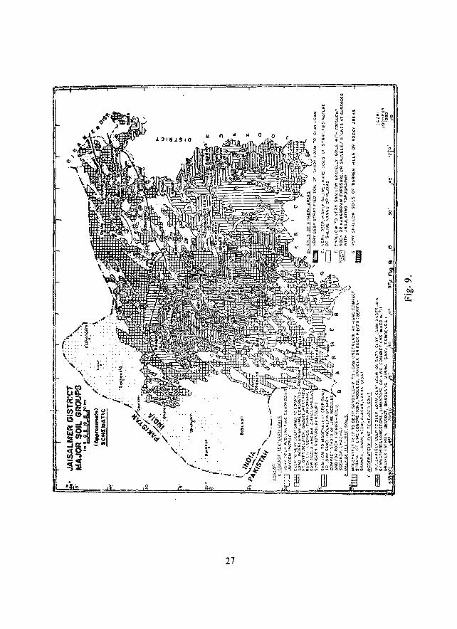
laisalmer district, inspite of its high aridity and moisture deficiency, has an immense variability of soil. Sediments from different rock sources and varied history of landscape evol ution have given rise to a wide range of soils, like the coarse aeolian sandy soils, the dune soils, the interd une soils, the moderately fine textured clay loam soils, the gravelly skeletal soils and the bare rocky outcrops.
Based on the morphological characteristics of soils, like texture, structure, colour, lime concretions, thickness of solum and soil depth, the major soils of the district have been mapped into 26 soil series. Considering the various phases within the series, like soil depth, extent of hummockiness, dune or interdune terrain, etc., the total soils mapping units are 55.
For this report the soil series have been grouped into broad textural classes and a major soil group map has been prepared (Fig. 9). Their major characteristics and distribution have been summarised in Table 6 and are described below.
1. Coarse textured soils
i) Coarse textured so;/s of dune complex alTd interdunes,' These soils Bre composed of very fine aeolian sand, deposited in the form of sand dunes and interspersed with interdunal plains. The~e are very deep soils of uniform profile characteristics, varying in colour from light yeJIowish brown (IO YR 6/4) to reddish brown (7.5 YR 4/4~. They generally comprise of 2 to 6% clay, 1.7 to 3.3% silt, 72 to 85.3% fine sand and 9.3 to 15.1 % coarse sand. The interdunal areas often have deep aeolian sands and are prone to high wjnd velocity.
ii) Coarse textured soils oj sandy plains,' These soils have wide spatial variability with respect to colour, particle size distribution, underlying strata, etc. Therefore, these have been divided into various series like Madasar, Shergarh, Thar, Dabla, Bhojka, Sam, Myajlar, Parewar and Chirai. While Madasar, Myajlar and Shergarh have negligible co.arse sand, Parewar, Bhojka and Dabla have appreciable proportion of medium to coarse sand. In general these soils are sandy at the surface and either sandy or loamy sand in sub soil, underlain at variable depth by weakly developed or moderately developed lime concretionary zone, or weathered rock or gravels/ pebbles. Generally most of these soils are prone to wind erosion/deposition and hence, the surface at many places is highly hummocky.
26
!!
ell
Ii: 0'1
~ I .!?P
27
(iii) Shallow coarse textured soils: Wherever the coarse sandy soils have depth limitation due to occurrence of a reasonably hard strata close to the surface, made up of either hard, cemented lime concretions, nodules or gravels, these have been mapped under the series Sodakor, Rajgarh, Ghotaru and Chacha, depending upon their profile characteristics and morphology. These soils are also prone to wind erosion.
Potentials and limitations: Most of the coarse textured soils are composed of sand and at places have loamy sand texture in the subsoil, with predominantly fine sandy component. These are devoid of any stable structure and therefore are loose and very friable. Often the soils are single grained and have very low water retention capacity (50 to 70 cm water per metre depth). '
Since vegetation cover on these soils is almost negligible these are highly susceptible to wind erosion. In fact, these soils serve as a source of dust during the
summer months.
With respect to fertility the soils are very poor in organic carbon (0.01 to 0.07%), poor in available phosphate (6 to ] 7 kg/ha), but have medium to high available potash (140-477 kg!ha). Yet the contents appear 'to be sufficient for sustaining the natural vegetation. The soils are, therefore, best suited for natural pastures, or developed pastures, especially Lasiurus sindicus grass. Plants like Ziziphlls nummularia, Capparis decidua and Leptadenia pyrotechnica are most common on these soils.
Agriculture without irrigation is not recommended.
Distribution: These soils occupy 14.1 % area of the district and occur in most parts, but have less occurrence in Pokaran tehsi!.
2. Medium textured soils
Soils of this group are formed of sediments from somewhat fine grained rock types. These soils are generally comprised of sand to loamy sand texture at the
. surface, grading to sandy loam texture in subsoil and underlain by variable materials like weathered fragments of sandstone, limestone, granite or conglomerate. Therefore, their colour, particle size distribution, calcareousness and amount of free lime or kankar differ widely. Among the series the Lawan, Lakha, Bida and Ajasar are reddish brown with their colour ranging from 7.5 YR to 2.5 YR. Ajasar has high
proportion of coarse sand, while Lawan and Lakha have less of coarse sand and more of fine sand. While Lawan and Ajasar soils have developed on sediments from red sandstone, Lakha and Sankra are associated with pink granite. Bida soils are associated with limestone. Rajgarh and Nedai soils of very old land surfaces are associated with conglomeratic material and assorted gravels, along with lime nodules. Thus, these soils are morphologically highly variable.
28
, Though these soils are sandy t<;> loamy sand at surface, they have sandy loam
texture in subsoil. indicating little more of clay and silt in subsoils. The clay con tent ranges from 9.9 to 15.8%, while the silt content ranges from 8.9 to 12.1 %. Coarse sand ranges from 11.2 to 27.9%, and fine sand from 47.3 to 68.2%. Thus, there is appreciable rise in clay and silt content and reduction in sandy compC'nent. Most of these soils are highly calcareous and their subsoils have weak to moderately developed
structure.
Potentials and limitations: These soils, having little more clay and silt component in subsoil and a weakly to moderately developed subangular blocky structure, retain 90 to 110 mm of water per metre depth, which is slightly more than that of sandy soils of earlier group. The soils are slightly less susceptible to wind erosion, although deposition of aeolian sand from adjoining' units is creating low sandy hummocks which need stabilization. The soils contain 0.04 of 0.24% organic carbon, 11 to 20 kg/ha of phosphate and 190 to 465 kg/ha of potash. Thus, these soils are low in nitrogen and phosphate, but medium to high in potash.
Although otherwise suitable for agriculture, the location of the soil in the extremely arid climate, discourages rainfed agriculture. However, agriculllll~ with irrigation would be more suitable on these soils. Otherwise, there is scope for developing pasture lands with suitable species and land management. Eleusine compressa, C. decidua, Ziziphus nummulada and Calotropis pro cera occur naturally on these units.
Distribution: These soils occupy 10.53% area of the district, especially around Bida. Lakha, Sankra, Rajgarh, Lawan, Ajasar and Nedai villages.
3. Medium to moderately fine textured soils
Most of the soils of this group are formed of either fine sediments or over weathering zone of fine grained rocks. The soils are nne textured and well aggregated. Therefore, these are subject to slight to moderate sand deposition. With the variation in parent lithology the soils differ in colour, particle size distribution, extent of calcareousness, depth and underlying strata, necessitating identification of series like Sanu, Marwa, Devikot, Ramdevra and Bhadasar.
Generally they range in texture from sandy loam to loam at surface and loam to clay loam in subsurface layers over gravelly strata of either fine grained pink sandstone or shale material or fine grained limestone or compact lime concretion. The colour ranges from yellowish brown (10 YR 5/4) to dark reddish brown (5 YR 4/4). Clay content in the subsoil ranges from 16.8 to 36.0%, silt from 8.3 to 263%, fine sand from 14 to 56% and coarse sand from 6.6 to 15.4%. Thus, the subsoil texture ranges from loam to clay loam, silty clay loam and gravelly clay loam. Marwa.
29
Ramdevra and Devikot series generally have deep phases and Bhadasar series has moderately deep to deep phases.
Potentials and limitations: These soils have appreciable structural developrrent and form good soil peds when ploughed. Being fine textured with better structural development, these soils have better water retention capacity (110-190 mm water per metre depth). However, soils shallo-wer than a metre may hold less water in profile.
The soils are poor in organic carbon, ranging from 0.04 to 0.36% and so are poor in nitrogen. Available phosphate is also poor, the range being lP to 18 kg/ha. Available potash, however, is enough, its range being 215 to 514 kg/ha. These nutrients, however, are seen to be sufficient to support natural vegetation and grasses of the region.
Due to the climatic constraints rainfed agriculture is hazardous. However, if potential runoff catchment are available nearby, these soils could be developed as good 'khadin' areas. Therefore 'khadin' type runoff agriculture can profitably be developed on such soils.
Distribution: These soils collectively occupy about 5.32% of the district and are scattered around Devikot, Fatehgarh, Sanu, Bhadasar, Ramgarh, Damodara,
Marwa and Ramdevra.
4. Soils of Khadin area
'Khadin' is a typical, age-old land use system of run-off agriculture in Jaisalmer area, wherein runoff water from adjoining rocky catchments is collecfed and impounded on low lying farm land for subsequent rabi cropping. Thus, it is a site-specific land use. Due to the regular settlement of fine sediments, brought down by water on the farm land and prolonged moist conditions which favour better weathering in the farm soils, khadin soils are medium to fine textured and stratified with better
. aggregation and clod formation.· They are generally very deep, with sandy loam to loam at s~rface and loam, clay loam and silty clay loam in the subsoils. Colour, particle size distribution, calcareousness, etc. differ with the rock type. Being medium to fine textured and well structured, these soils hold 130-220 mm water per metre depth. Fertility status is better than in many soils of the region.
Organic carbon content ranges from 0.26 to 0.70%. Available phosphate ranges from 24 to 68 kg/ha. Available potash varies from 240 to 920 kg/ha. Thus, these are the most fertile soils of the region. Because of the availability of runoff water, these are also the suitable sites for rainfed agriculture and especially the
rabi crops.
30
t
Potentials and limitations: Pr9per development of the khadin catchment and channelisation of the runoff water to the 'khadin' are necessary for best results. There is also need to frequent:y level the farm lands and to maintain khadin bunds, for
uniform distribution of water over the farm land.
New khadins could be developed on medium to fine textured soils if proper
catchments exist in the proximity.
Distribution: Although small khadins of 1-5 ha are scattered in the district, those could not be mapped at small scale. Large, mappable khadins occupy 0.7% of the district. A number of new khadins are also coming up.
5. Shallow gravelly/rocky soils of piedmont zones
These miscellaneous types of soil occur in nearly level to gently undulating rocky or hilly situations. The surface of these soils is strewn with gravels and pebbles to the extent of 5 to 20 per cent, although patches having gravels as high as 70 per
cent are also found.
The 10 to 40 cm deep solum is usually mixed with gravels and the underlying strata is often gravelly or concretionary and indurated.
The gravel-free soil in the solum has a texture of sand to fine sandy loam, with clay content of 7 to 13 per cent and silt of 6 to 11 per cent. Soils can retain only 15 to 35 mm of moisture in the solum. These soils have reasonably good amount of plant ;)utrients to support natural vegetation. The soil tends to form crust. This factor, together with gravel component, generate significant runolf even under low intensity rains, which can be collected for better utilization. These soils are suitable for pasture development with suitable species and soil working.
Distribution: These soils occupy 3.17% area of the district and cover large area around Pokaran, Jaisalmer, Rajgarh and Ramgarh.
6. Salt -affected soils
Salt affected soils largely occur in the saline 'plaYfls' (or the Ranns) like the Khara Rann, Mitha Rann, Pokaran Ka Rann, That Ka Rann, Jhalaria Ka Rann, Phulasar Ka Rann, Lawan Ka Rann, Kanod Ka Rann, etc. The soils vary from sand to loamy sand, sandy loam, clay loam and silty clay loam. Although these are highly charged with soluble salts, the salt content varies spatially as well as in profile. The electrical conductivity ranges from 100 mmhos to as high as 2, 200 mmhos. The soils
are, therefore, unsuitable for agriculture and prohibit growth of natural vegetation. As such, most of these areas are practically barren.
31
Potentials and limitations: Although the soils are highly saline, at suitable sites with fairly low salt concentration suitable land layout, like making ridges and ditches or raised beds or bunds, etc. can help in plantation of highly salt tolerant species of
grasses and trees. Distribution: These soils occupy nearly 0.51 % area of the district.
7. Soils of rocky hills and plateaus This unit comprises ofhiI1s, dissected plateaus and other uplands on sandstone,
limestone, granites, etc. The soil cover is very scanty and thin. At platles the western flanks are covered with aeolian sand and form good media for natural vegetation.
Problems alld potentials: These areas, due to lack of soil cover and soil depth,
support very little vegetation, but can form good runoff potential areas for harvesting
runoff. Distribution: This unit occupies nearly 5.71 0
/(, area of the district.
Table 6. Major soil types of laisalmer district and their characteristics
Potentials and/or Precent
Major soil type Major characteristics limitations area
1. Coarse textured sandy soils of duny complex a) Dunes and interdunes Very deep, very fine, Highly susceptible to wind 43.04
calcareous aeoiian sands, erosion; poor moisture
single grained retention; rolling topography; very deep rooting zone
b) Very deep soils of Very fine sand to loamy Highly susceptible to wind ILlS
sandy plain (Madasar, fine sand in subsoil; \ery erosion; poor moisture
Shergarh, Thar, Dabla, deep with slight to highly retention; often hummocky
Bhojka, Sam, Myajlar, hummocky phases; very relief; very deep rooting
Parewar, Chirai series) weak structured zone.
c) Moderately deep soils Same as above Same as above, but underlain 12.84
of sandy plains by moderate to well developed
(Sodakor, Rajgarh, lime kankar zone within 40-70
Kolu, Ghotaru, Chacha em depth; limited rooting zone
series).
2. Moderately coarse
textured soils a) Deep to very deep Very deep loamy sand to Susceptible to wind deposition; 3.59
(Lawan, Lakha, Ajasar, sandy loam; often with slightly better moisture
Nedai series) slight to moderate hum- retention mocky phases
b) Moderately dee I? soils Moderately deep soils of Root zone limitation; low 6.94
(Bida. Sankra, Nedai, loamy sand with sandy moisture retention; susceptible
Rajgarh series), Ajasar loam at subsoil underlain to wind deposition
Lakha, Lawan, Bhojka by hard strata
and Rajgarh varient (Contd.)
32
(Contd.)
Major soil type Major characteristics Potentials and/or limitations
Percent area
3. Medium to moderately Moderately deep to deep Better water retention; not 5.32
fine textured soils (Sanu, soils of loam to clay loam susceptible to wind erosion, Marwa, Devikot, Ram- texture in subsoil underlain but often sand deposit on devra, Bhadasar series) ~ by hard strata surface
4. Deep soils of 'Khadin' Deep alluvial soils _of local Good for ensured rainfed 0.74
area
5. Shallow gravelly, rocky soils of piedmont zones
6. Salt affected soils
sediments, -medium to moderately fine textured
Very shallow gravelly soils with variable lithology
and texture
cropping
Poor water retention; undulating to slcping
land; gravels and stones strewn on surface
Very deep moderately fine High salinity; sometimes textured stratified soils inundated; barren of low depressions and Ranns
3.13
0.52
7. Soils of rocky hills and Rocky, sloping areas with Exposed rocky surface; 5.71 plateaus pockets of shallow high runoff potential
skeletal soils
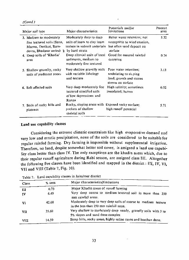
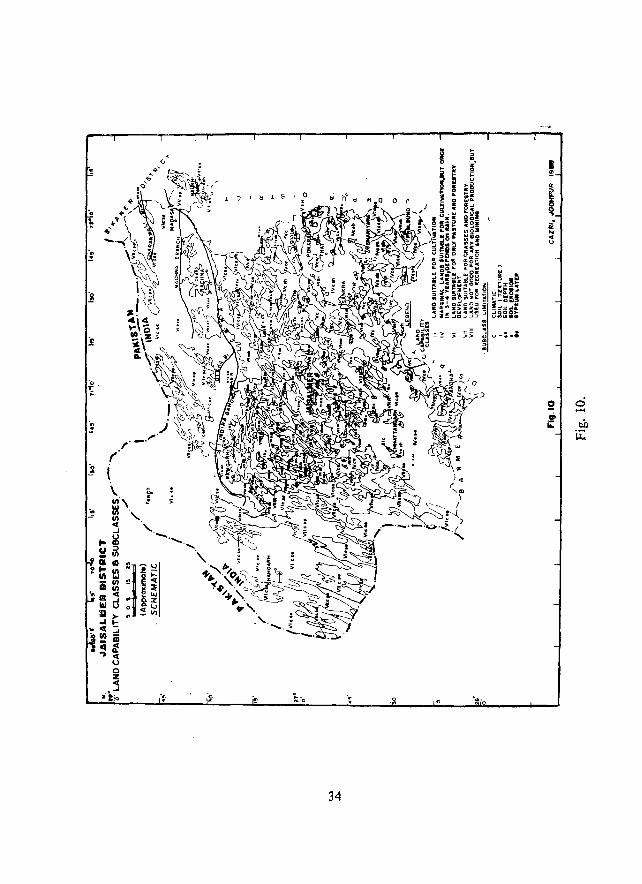
Land use capability classes
Considering the extreme climatic constraints like high evaporative demand and very low and erratic precipitation, none of the soils are considered to be suitable for regular rainfed farming. Dry farming is impossible without supplemental irrigation. Therefore, 110 land, despite somewhat better soil cover, is assigned a land use capabilitv class better than class IV. The only exceptions are the khadin aleas which due to th~ir regular runoff agriculture during Rabi season, are assigned class III. AI;ogether the following five classes have been identified and mapped in the district: III, IV, VI, VII and VIII (Table 7, Fig. 10).
Table 7. Land capability classes in Jaisalmer district
Class
1lI IV
VI
VII
VIII
% area
0.73
6.49
42.68
35.60
14.50
Major characteristics/limitations
Major Khadin areas of runoff farming
Very deep coarse to medium textured soil in more than 250 mm rainfall areas.
Moderately deep to very deep soils of coarse to medium texture in the less than 250 mm rainfall Zone.
Very shallow to moderately deep sandy, gravelly soils with 3 to 5% slopes and sand dune complex
Steep hills, rocky areas, highly saline ranns and barchan dune.
33
34
• !!!
~ .. o
5! ... ii:
0 ..... tl1)
ii:
CHAPTER VI
VEGETATION
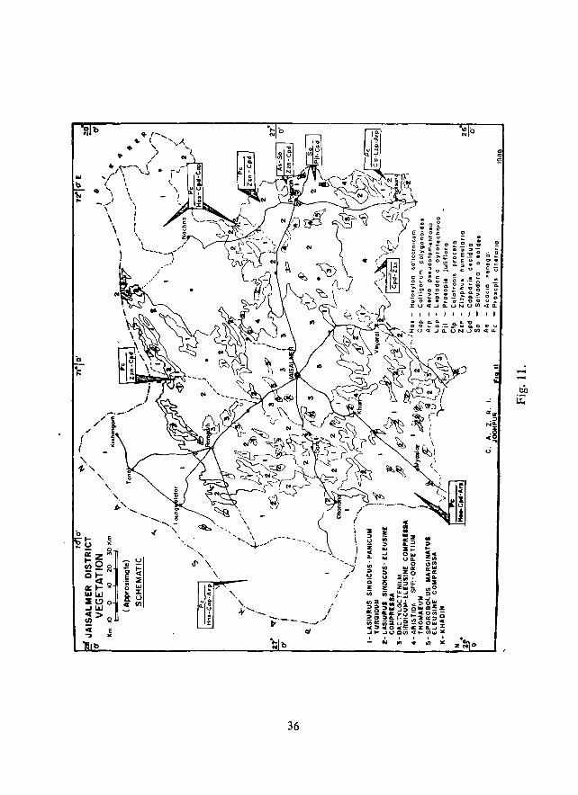
Trees are rare in Jaisalmer district. Hence the terrain gets a look of sparse grassland with sprinkling of shrubs and small trees, many of which have forage value (Fig. 11). The distribution and characteristics of grasses, shrubs and trees on different habitats are described below.
(a) Major communities
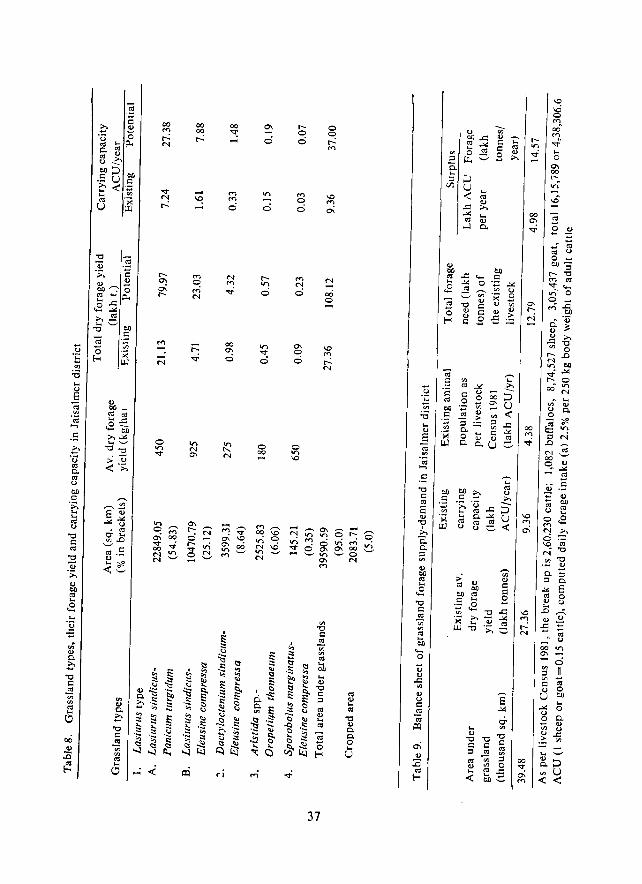
1. Grasslands
Four major grassland types have been identified in Jaisalmer district. These are: (1) Lasiurus sindicus type, occurring over 80% of the geographical area of the district; (2) Dactyloctenium sindicum - Eleusine compressa, occupying 8.64% area; (3) Aristida-Oropetium thomaeum, covering 6.06% area; and (4) Sporobolus marginatusEleusine compressa on 3.5% area. Lasillrus sindiclls has two subtypes: (a) Lasiurus sindicus - Eleusine compressa, dominating on sandy plains (on 25% area) (Fig. 11), especially in the northwest and (b) Lasiurus sindiclls - Panicum turgidum, occupying 55% area, mainly on dunes and interdunes in the northeast and southwest. AristidaOropetium type occurs on rocky/gravelly surfaces and lower slupes of the central rocky uplands of the district. Sporobolus marginatus - Eleusine compressa type is restricted to the saline depressions. Dac/yloctenium sindicum - Eleusine compressa appears on thin soil mantles in the south eastern part of the district.
Average dry forage yield was maximum in Lasiurus sindicus type (687 kg/ha), followed by Sporobolus marginatus - E. compressa (650 kg/ha). D. sindicum - E. com
pressa (275 kg/ha) and Aris/ida - Oropefium thomaeum (180 kg/ha). Similar trend is also observed in their average carrying capacity (Table 8). Total dry matter yield and carrying capacity is maximum in LasiurliS sindicus - P. turgidum type, followed by L. sindicus - E. compressa and S. marginatus - E. compressa types. Estimates show that potential forage yield, which is the maximum possible yield under protection, can be increased four times per year. The existing average dry forage yield of 27.36 lakh tonnes is estimated to have carrying capacity of 12.5 lakh ACU/year. The actual livestock population, as per 1981 gazetter is 4.38 lakh ACU/year. The district has, therefore, a surplus of 14.27 lakh tonnes of dry forage yield (Table 9) which can support double the present livestock population.
35
. .., " . ~ g .
~
(> ._ = o.
~ -' u: «rr.
:::>
~~ c.,
U
". !
\. I ~'-.- /
~'-'-'-'-/' <:I
36
u '5 '" ;0 .... '" 8
-a .~
.....
. 5
00 0\ o
o 00
r-o o
0\ o o
o or) \0
37
\0
'" ai
N -00 o
\0
'" r--N
ca '" ... ca '0
~ C. o U
Besides, Bordi (Ziziphus nummularia), Kltejri (Prosopis cineraria) and Lana, (Haloxylon salicornicllm) are important browse yielding shrubs and trees. While Bord; abounds on the rocky/gravelly habitats in the south east, Lana is abundant on the sandy plains of the north west, making the entire district self sufficient in Bordi and Lana browse.
2. Tree-shrub cover
Trees and shrubs on various habitats and their density (no/ha; figures within brackets following each species) are described below. The average density and frequency of occurrence of trees, shrubs and grasses in different. habitats are also given in Table 10.
i) Piedmont areas: Salradora oleoides (43 plants/ha), Capparis decidua (40) and Grewia tenax (27) were major trees and shrubs, respectively on such habitats. Because of heavy exploitation the population of Commiphora wightii (20) has been greatly affected. Euphorbia caduci/olia (70) and Acacia senegal (170) were dominant on rocky surfaces while on colluvial surfaces Prosopis cineraria (45) and Ziziphus llummlliaria (66) gained dominance. On sandy colluvial surfl!-ces Calotropis procera (15), Aerva pseudotomentosa (170) and Lasiurus sindicus do also appear.
ii) Buried pediments: Ziziphus nummularia (81 plants/ha, 70% frequency of occurrence) and Capparis decidua (58 plants/ha; 85% frequency of occurrence) formed the dominant shrub cover, while Grewia tenax (15 plants/ha), Lycium barbafllm (30 plants/ha) and Aerva pseud%mentosa (48 plants/ha) were the major associates. Among the trees Salvadora oleoides (30 plants/ha) and Prosopis cineraria (10 plants/ ha) were dominant and Acacia senegal was the associate. Haloxylon salicornicum (250 plant/ha) had an exclusive dominance on buried pediments in the northwest.
iii) Ranns (saline depressions) : The middle of the ranns were bare due to recurring inundation and high salinity. The peripheral areas had predominant shrubs of Tamarix dioica (40 plants/ha) and Ziziphus nummularia (40 plants/ha) and also Salvadora oleoides (261 plants/ha) trees. Away from the ranns and with gradually increasing, sand cover Calligonum polygonoides (50 plants/ha), Aerva pseudotomelltosa (723 plants!ha) and Lasiurus sindicus (554 plants/ha) become dominant in the
sequence mentioned.
iv) Dunes and interdunes: These habitats in the southeastern part support Calligonum polygonoides - Calotropis pro cera - Aerva pseudotomentosa shrub cover, while in the northwest Calligoflum polygofloides - Haloxylon salicornicum - Leptadenia pyrotechnica become dominant. Sa/vadora oleoides and Prosopis cineraria occur sporadically in the interdunes only. Ziziphus Iltlmmularia and Capparis decidua do also occur, but in less number (10-36 plants/ha).
38
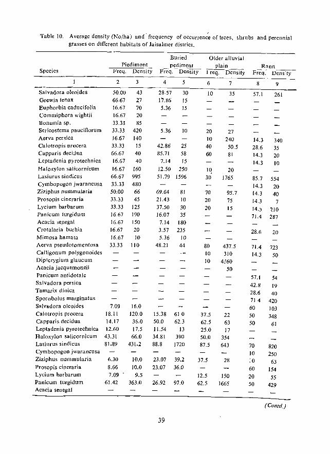
Table 10. Average density (No(haj and' frequency of OCCurrence of trees, shrubs and perennial grasses on different habitats of Jaisalmer district.
Buried Older alluvial Piedimont pediment plain Rann
Species Freq. Density Freq. - Density ~Density Freq:- Dens:ty -
2 3 4 5 6 7 8 9
Salvadora oleoides 50.00 43 28.57 30 10 35 57.1 261 Grewia tenax 66.67 27 17.86 15 Euphorbia caducifolia 16.67 70 5.36 15 Commiphora wightii 16.67 20 Bonamia sp. 33.33 85 Sericostema pauciflorum 33.33 420 5.36 10 20 27 Aerva persica 16.67 140 10 240 14.3 340 Calotropis procera 33.33 15 42.86 25 40 50.5 28.6 35 Capparis decidua 66.67 40 85.71 58 60 81 14.3 20 Leptadenia pyrotechnica 16.67 40 7.14 15 14.3 10 Haloxylon salicornicum 16.67 160 12.50 250 10 20 Lasiurus sindicus 66.67 995 51.79 1596 30 1765 85.7 554 Cymbopogon jwarancusa 33.33 480 14.3 20 Ziziphus nummularia 50.00 66 69.64 81 70 95.7 14.3 40 Prosopis cineraria 33.33 45 21.43 10 20 75 14.3 7 Lycium barbarum 33.33 125 37.50 30 20 15 14.) 210 Panicllm turgidum 16.67 190 16.07 35 71.4 287 Acacia se.negal 16.67 150 7.14 180 C'rotalaria burhia 16.67 20 3.57 235 28.6 20 Mimosa hamata 16.67 10 5.36 10 Aerva pseudotomentosa 33.33 110 48.21 44 80 437.5 71.4 723 Calligonum polygonoides 10 310 14.3 50 Dip1erygium gJaucum 10 4360 Acacia jacquemontii 50 Panicum antidotale 57.1 54 Salvadora persica 42.8 19 Tamarix dioica 28.6 40 Sporobolus marginatlls 714 420 Salvadora oleoides 7.09 16.0 60 103 Calotropis procera 18.11 120.0 15.38 610 37.5 22 50 348 Capparis decidua 14.17 35.0 50.0 62.3 62.5 63 50 61 Leptadenia pyrotechnica 12.60 17.5 11.54 13 25.0 17 Haloxylon salicornicum 43.31 66.0 34.81 390 50.0 354 Lasiurus sindicus 81.89 431.2 88.8 1720 87.5 643 70 820 Cymbopogon jwarancusa 10 250 Ziziphus nummularia 6.30 10.0 23.07 39.2 37.5 28 :0 63 Prosopis cineraria 8.66 10.0 23.07 36.0 60 154 Lycium barbarum 7.09 9.5 12.5 150 20 55 Panicum turgidum 61.42 363.0 26.92 97.0 62.5 1665 50 429 Acacia senegal
(COntd.)
39
(Conrd.)
2 3 4 5 6 7 8 9
Crotalaria burhia 25,0 65 10 30
Mimosa hamata 20 58
Aerva pseudotomentosa 84.25 405.2 46.15 715 100.0 469 80 862
Calligonum polygonoides 69.29 201.6 15.38 162.5
Dipterygium glaucum 25.0 490
Acacia jacquemontii 1.57 20.0
Panicum antidotale 10 300
Salvadora persica
Tamarix dioica 40 46
Sporobolus marginatus
Heliotropium nerifolium 20 15
Acacia nilotica 20 13
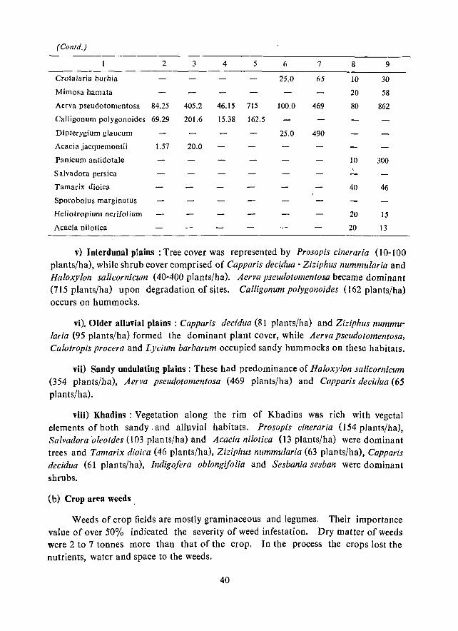
v) Interdunal plains: Tree cover was represented by Prosopis cineraria (10-100 plants/ha), while shrub cover comprised of Capparis decI:dua - Ziziphus nummularia and Haloxylon salicornicum (40-400 plants/ha). Aerva pseud%men/osa became dominant (715 plants/ha) upon degradation of sjtes. Calligonum polygonoides (162 plants/ha) occurs on hummocks.
vi). Older alhlvial plains: Capparis decidua (81 plants/ha) and Ziziphus nummularia (95 plants/ha) formed the dominant plant cover, while Aerva pseudotomen/osa, Calotropis pro cera and Lycium barbarum occupied sandy hummocks on these habitats.
vii) Sandy undulating plains: These had predominance of Haloxylon saJicornicum (354 plants/ha), Aerva pseud%mentosa (469 plants/ha) and Capparis decidua (65
plants/ha).
viii) Khadins : Vegetation along the rim of Khadins was rich with vegetal elements of both sandy. and alluvial habitats. Prosapis cineraria (154 plants/ha), Salvadara aleoides (l03 plan ts/ha) and Acacia nilotica (13 plants/ha) were dominant trees and Tamarix dioica (46 plants/ha), Ziziphus nummularia (63 plants/ha), Capparis decidua (61 plants/ha), Indigo/era oblongifolia and Sesbania sesban were dominant
shrubs.
(b) Crop area weeds.
Weeds of crop fields are mostly graminaceous and legumes. Their importance value of over 50% indicated the severity of weed infestation. Dry matter of weeds were 2 to 7 tonnes more than that of the crop. In the process the crops lost the nutrients, water and space to the weeds.
40
(c) Evaluation of vegetation cover
Only Bhadriya and Ramdevra have typical relict vegetation which bear a semblance of forest' stand of Z. nummularia and Capparis decidua. Barabagh near Jaisahner town also has good stand of trees, but by and large trees are badly cut, browsed and lopped, until they ultimately disappear. Range condition analysis at 114 sites revealed that only 13% of the grasslands belonged to 'good' class; 14% to 'fair' class and 73% to 'poor' and 'very poor' classes. Protection and range reseeding can bring these grasslands to 'good' class status.
41
CHAPTER VII
SURFACE WATER
laisalmer district, because of its low and erratic rainfall, is a chronically waterscarcity district. Because of deep ground water over most parts, the people generally rely on village tanks (nadis), tankas and Khadin system of water conservation for cultivation. These practices aim to collect maximum rainfall water and to use the same either for human and livestock drinking or for bed cultivation. However, there are serious problems of water loss through seepage and evaporation, and sedimentation in these traditional structures. The streams in the district are short, ephemeral and carry flow during abnormally high rain storms.
(a) Dependable rainfall for surface wattr structures
Analysis of rainfall (1961-87) of six raingauging stations at laisalmer, Pokaran, Nachna, Ramgarh, Sam and Fatehgarh indicated that the averafe rainfall varies from 99.5 mm at Fatehgarh to 173.3 mm at laisalmer (Table 11). At laisalmer the rainfall was less than 150 mm in 51.85 percent of the 27 rainfall years. Designing of any water harvesting structure on the basis of such an average rainfall may be misleading. Therefore, the 60% probability curves for each raingauging station were drawn for prediction of the dependable rainfall for drinking water harvesting structures and the return period of such rainfall years (Fig. 12). The 60 percent probability was worked out through Log Pearson Type III distribution. Dependable rainfall at 60 percent probability level for designing of drinking water harvesting structures worked out to be 107 mm, 130 mm, lOS mm, 87 mm, 90 mm and 52 mm for laisalmer, Pokaran,
Nachna, Sam, Ramgarh and fatehgarh, respectively and their surrounding areas. For other structures in the district, like earthen dams, the amount of rainfall may be considered having a return period of one in 10 years, while for masonry structures the return period is one in 5 years (Table 12).
(b) Present surface water resources
(I) Village tanks (nadis) : Nearly 60.68% area of the district is covered with high to medium sand dunes, interdunes and sandy undulatirJg plains where surface water potentiality is very meagre due to the absence of potential drainage channels (Fig. 13). However, short drainage channels occur on gravelly and rocky surfaces, but carry very little runoff during normal rainfall period and disappear at short dist
ances in sandy areas (Fig. 14).
42
Table II. Rainfall pattern (1961-87) in laisalmer District
Name of rain- Average Standard Co-efficient gauging station rainfall deviation of variation
(mmJ: (%)
I. Jaisalmer 173.3 124.2 72 2. Pokaran 169.6 89.9 53 3. Nachna 144.0 66.2 46 4. Ramgarh 124.1 80.6 65 5. Sam 152.6 148.0 97 6. Fatehgarh 99.5 105.7 106
Overall average 143.83
Table 12. Designed storm at various probability levels for laisalmer District
Designed rainfall Return Proba- ----------------------------------period bility Jais- Pokaran Nachna Sam Ram- Fateh-(years) almer garh garh
1.01 99 :n 44 26 28 20 2.0 50 130 150 125 110 90 67 5.0 20 251 230 220 230 200 172
10.0 10 355 300 300 242 280 275 20.0 5 470 360 400 465 385 -160 50.0 2 645 450 520 680 485 ,,20
100.0 800 510 620 870 590 870
There are 1822 nadis in the district, capable to store 38.377 mcm of water during normal rainfall year (Fig. 13). Out of these only 277 nadis are large (I5 .20%; capacity greater than 0.03 mcm); 364 are medium (19.97%: capacity 0.01-0.03 mcm) and 1181 are small (64.83%; capacity ranging from 0.005 to 0.01 mcm). Almost all the villages have at least one nadi of large to medium size, except in the sandy areas where nadis are of small capacity. Large capacity nadis are located in the gravelly or stony catchments which generate more runoff. Some of the villages having more number of large nadis are Seu, Ramgarh, Kathori, Dedha, Khuri, Dabhala, laisalmer town, Morha, Randha, Nimbli, Mohangarh, Machhera and Khetolai. Small capacity nadis are situated in interdune areas. Their drawbacks are: (a) the stored water is available from I to 6 months of the year, mainly due to heavy seepage and evaporation losses; (b) deposition of sediments, and (c) deposition of blown sand. The deposition of sediments and blown sand decrease the capacity of nadis every year. Therefore, the villages depending only on the surface water resources are facing acute scarcity of drinking water.
(2) Tanka: The water harvesting through tanka system plays an important role in mitigating the drinking water requirement, particularly for people living in scattered settlements on dunes, interdunal plains and undulating sandy plains. Tanka pro-
43
8 8 .., ., o o ,., 8
N 11'1:H,f.WlI (WW)
44
UJ U Z UJ
" c::: :;) u u o ... 0
UJ U Z « J: u
£:.I <:J IL.
N ....
"-\
\. "-" "
\
4S
I I
/ /
/
/ i i , i I
j
r·_ -.-.-. .._._ ........ ~.,
46
vides reliable safe drinking water to consumers. In almost every village the tankas are constructed: on individual household basis or on community basis. Those constructed on individual household basis do not ensure adequate supply of water throughout the. year. This is mainly because the anifici<ll catchments provided for generating- .runoff: are not enough for the pre.valent lean rainfall years. Further, the structures construc
ted by local practices need modification in constructional details and in preparation of artificial catchments so that the availability of water is ensured throughout the year, even in below-normal rainfall years.
(3) Khadin : Runoff harvested in low-lying areas from the surrounding rocky catchments for practicing agriculture (or khadin system) have great significance in the district. In some cases the runoff water is diverted through small channels to farm lands in lower reaches. Bunds constructed across the slope and farm lands lying between the ridges of the catchment are normally inundated with water during monsoon period, but on drying the rabi crops are sown. During drought years, such fields are put under kharif crops.
About 84 khadins have been constructed by the Irrigation Department, Government of Rajasthan. The catchment areas of these khadins vary from 2.5 to 51.0 sq. km with storage capacity ranging from 0.028 to 2.33 mcm. The total storage capacity at F.T.L. is about I t.9l mcm. Apart from these, there are several privately owned khadins, constructed by cultivators on their farms. This practice of water harvesting on farmland is thus gaining popularity in the district.
(c) Water requirement and dependency on sources
Following is the annual water requirement under different uses in the district.
1. Drinking water for human popUlation 5.680 mcm 2. Drinking water for livestock population 5.114 mem
3. Irrigation by surface water 4. Kharif crops (optimum production)
(a) Sown area (2467.41 sq. km) (b) Culturable waste (3002 t.98 sq. km)
Total 10.794 mcm PracticalJy nil
986.964 mcm 12008.792 mem
Total 12995.756 mem
Thus the total annual wate requirement in the district is 13,006.55 mcm.
Drinking water requirement for human and livestock is met partly from groundwater and partly from surface water storage structures. I rrigated crops are practically nil and kharifcrops are rain fed. During an average rainfall year (143.83 mcm) the
district generates 5520.76 mcm of water which clearly indicates that there is water deficiency for optimum production of crops and even drinking water. Nearly
47 '

85.27% villages of Jaisalmer tehsil and 90.52% villages of Pokaran tehsil therefore, depel1d on dug wells, tubewells, hand pumps alongwith nadi find tanka water (Table 13). Hence, to reduce the stress on groun.d water resources suitable measures to augment the surface water conservation practices are necessary. The list of villages facing acute drinking water problem is provided in Appendix II.
48

... U "'l
Itt 0;: i5 0 ... '" ..". <'t \0 V'I V'I N
~ V'I 0 tJ "0 0 M
.,.. N ~ 00 \0 0 .... 0 or; ci <"i N or; 0 0
.~ c: ..". N N
0= 0 C; E V'I ..... .,.. VI a- M .,.. M N '0 '" QO ..... 0\ N '" ..". f-< "0 .....
C: "' a- 0 \0 N 0 ... ... QO ..... ~ 00 ~ 0 ... eo .,r <"i 0 ci .. $l ;;:; 00 ... "'I" 0 c: Il.
<'d ... Itt ~ 0 '" Q., .... ...
0 eo l'I '" ..... 0 :g .,.. ..... .... ..... \0
~ 0;;
0<;; ..c;
~ oW
0
"E c: 0\ 0\ \0 ..". 0 \0 M ...., 0
'" '" "'I" ..... ..... 0 \0 ..... ...., 00 0
." t) 00 00 oi Ici .,r N <"i .,r ci 0 .. ii ... ~ M M ..... 0 ... .. Q., ... ., e e -; d '" '" 00; ~ ... '" .... 0 ...
0= 00 ..., 0 00 :!; a- M V'I M c:i ~ .... on ..... \0 ..,
'" Z 0;; ..... i1 ~ 0 .,
~ ... ~
~ Itt ~
'" IlJl Co c: e :.Q ::l c: Q.
OJ; 'C
'C '" C '" .... Itt Itt
'" 0 ~ .c ~
C c: 'C c: <U ~ C ~ I:l ~ en ..s til ., 'C '" '" "0 CU 'C ::l Q ~ Q ~ I:l 0 '" '"
Q.
'" C (J '" '" ~ $l » '" ~ C. <U
... ii .:i -a °C Q ~ «I 'C
0 I!> 'C o:s c: '" U .0 C ~ '" '" cd
<"i :§. !l il: CU .~ .. '" '" !l CI)
" ~ ii :a c u ~
.0 C "0
~ <U :.Q ~ ::l cd Itt <II <II
:c c:; f-< Eo-< Z Z Z ~
0;:: Q ....; N ..; .,r or; Ici r-: .00
49
CHAPTER VIn
HYDROGEOLOGICAL CONDITIONS
The ground water in Jaisalmer district occurs in almost all formations, but the quality and quantity vary considerably in different rock types. A number of perched aquifers, containing good quality of ground water, support domestic and livestock requirements through shallow open dug wells, known as 'berris'. Lathi Sandstone and Pare War Sandstone form very promising ground water aquifers wherein it occurs under semi -confined and unconfined conditions. In Jaisalmer Limestone and crystalline igneouG formations groundwater occurs in limited quantity under water table conditions.
Hydroge()logical units
Eleven major hydrogeological units have been delineated (Fig. 15) and depth to water in them have been worked out (Fig. 16). The details are as follows:
(1) Crystallines-Rhyolites and Granites: The Malani rhyolites form shallow aquifers in the eastern part of the district where these are exposed near Pokaran, Bhaniana, Kelawa, Phalsund, Phulasar, Lawan etc. The ground water occurs in limited quantity under water table conditions. The yield of wells is restricted due to limited thickness of weathered 'and fractured zones.
The granites form hydrogeological unit around Sankra, Modardi, Chok,
Khuhra, kunda, Bhadli and Lakera. It forms fresh to potable water aquifers and ground Water movement is through fractures and joint planes under water table conditions. Depth to water varies from 15.00 m (Ratdiya) to 68.06 m (Sada) .
. (2) Jodhpur S~ndstone -: Jodhpur Sandstone forms aquifer towards eastern part of the dis,trict around Gomat, Pokaran, Bhakri, Ratdiya, Padroda, Jhabra, Sangram Singh Ki Dhani. Baiteena and Khelana. The depth to water in these formations is generally shallow, the minimum being at Pokaran (620m) and the maximum at Jhalaria (~1.70m). These formations yield low to moderate discharge, varying from 2.0 to 12.0 cub.ic metres per day. The quality of groundwater is generally potable.
(3) Lathi Sandstone: Lathi Sandstone forms the most extensive and productive aquifers ill the district due to high permeability and transmissivity of the formation. A number of tubewells have been drilled in this formation around Dabla, Lathi, Chandan, Bhojka, Sodhakor, Devikot, Fatehgarh etc.
50
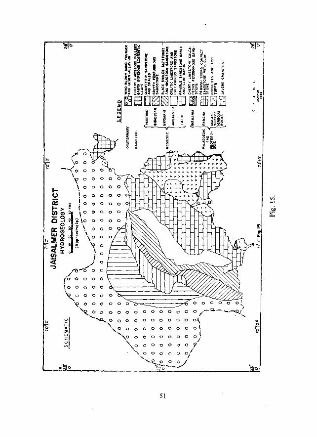
b ·N ....
(>
;::.
"0 ·0 ...
._ 0 ~ ._ en -Q
0:: LIJ
3 <t en <i ..,
,-, ~:( >
.. ... ... i .. " '"
('11 o~ \0 0 0 ~}
_ . ..( 0 0 ~""\ . 0 ~
~ ... >,.>,.»~>\ » :»="»»,.,.".)
> >:>;10 »:»»
\ --'~ooooo
\ 0 0 0 0
i 0 0 0 0
io 0 i 0 0 0
,0 0 0 0 0
.\0 0 0 0 ;; \ .~ . 0 0 .. , i \0 0
: .~ 0
- ) 0
_".) 0
.I"'b-b 0 0 . ./ (0 0 0 0 0
\0 0 0 0 0
'\1 l) 0 0 0 /J "
w :J: U V)
'~oooo ooooo( "~ 0 0 0 0 0 0 0 0 0 0 0 0 0 ._.o.. ___ ._Q./
. / - "
.... -...0.... 0 0 0 0 0 0 0 0 0 0 o( " 0 0 0 0 0 0 0 0 0 t ·'·~·,o 0 0 0 0 0 0 0 oj
". 0 0 0 0 0 0 0 ,,'
", 0 0 0 ('. 0 0/ " .I
".':2.., 0 0 0 I O~b-'-'''''
51
(>
... o .~
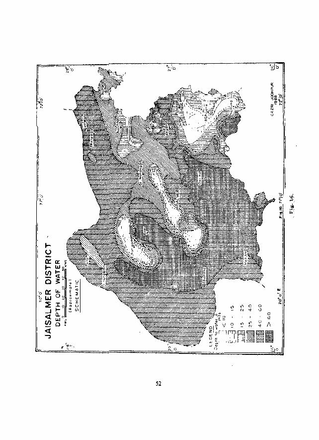
~'2 I ~
I
I I I I I I I
\
-0 ~.
~ .... ,._ tot·
l~. ~I ur iO;
!.~
52
The depth to water in Lathi Sandstone varies considerably, the minimum being at Tadana (14.0 m) and the maximum at Bhakrani (129.0 m). The total soluble salt .content varies from 640 ppm at Dholia to 5120 ppm at Bhojka.
(4) Jaisalmer Formation: This formation is composed of calcareous sandstones with arenaceous limestones and is intercalated with shales. Groundwater movement is through pore spaces and joint planes. Depth to water ranges from 8.00 m at Deunga to 78.00 ill at Pithala. The total soluble salt content varies from 608 ppm at Dhawa to 4480 ppm at Bhojasar. The highest TSS content was noted at Kunjal Ki Dhani i.e. 16380 ppm. Discharge in these formations is meagre and at a few places like Amar Sagar, 8adabad, etc., groundwater occurs in perched water condition, ",hich supply limited ground water through shallow open dug wells.
(5) Baisakhi Formation: This formation is composed of black shales with siltstones and micaceous sandstone and does not form any promising aquifer due to lack of sufficient granular zones. Ground water generally occurs under perched water conditions. Depth to water varies considerably and ranges from 17.00 m at Chhatrel to 101.00 m at Bersiala. Total soluble salt content varies from 1440 ppm at Dewa to 9600 ppm at Khariya. At Cbaudhariya the total soluble salt is the highest i.e. 13,760 ppm. The yield of tube wells, drilled in this formation, varies from 2.5 Ips a, Satto to 10 Ips at Khuri.
(6) Bedesar Formation: These are gritty ferrugi no us sandstones intercalated with shale bands and gypseous clay beds. These form projuctive aquifers at some of the places like Myajlar where coar,e grained sandstones yield moderate discharge, though the quality is slightly saline. Depth to water in these formations varies from 51.00 m at Boa to 128.40 m at Bida. The total soluble salt content varies from 960 ppm at Ugawa to 5120 ppm at Myajlar. The highest total soluble salt content has been noted at Salkha (10, 880 ppm). Perched water conditions are also found within the formation e.g. at Kanoi where depth to water is 13.70 m and the quality of ground water is also good, containing total soluble salts of 640 ppm.
(7) Parewar Formation: This formation comprises of felspathic and ferruginous sandstones which form an important aquifer around Sanu and Parewar where a
. number of tubewells are yielding good quality of ground water. the depth to water va ries from about 68.00 m at Joga to about 125.00 m at Mokal. The yield of tubewelis drilled near Parewar village is 72.64 cubic metres per day, whereas at San u the yield is 360 cubic metres per day. The quality of ground water is generally potable, but at Deega the quality of ground water is highly saline, where total soluble salt content is 12, 160 ppm.
(8) Eocene Formations: These include the Khuiala and the Randah formations. The Khuiala formation comprises of coarst: grained sandstones, greenish or yellowish
53
brown gypseous clay and chalky and fragmental limestone. The i3andah Limestone
comprises of gypseous bentonite clay, marly layers, fragmental and crystalline
lim<!stone. The ground water in these formations generally occur at shallow depth. Due to limited saturated thickness of granular horizons these formations do not form
promising aquifers. Depth to water in these formations varies from 22.00 m at Sam
to 67.00 m at Joga. The total soluble salt content ranges from 608 ppm (Khuiyala)
to 5800 ppm at Sultana. The discharge is generally low and meagre. It varies from 2.5 Ips to 3.5 Ips.
(9) Older alluvium: The older alluvium comprises of sand, gravel and clay intercalations, alongwith Kankar pans. These form hydrogeological unit along the north
ea3tern part of the district. Depth to water ranges from 15.26 m (Awai) to 46.0 m
(Tawariwala). The total soluble salt content varies from 1984 ppm at Panna to 3968 ppm at Panchewala tala.
(10) Younger alluvium: The sediments belonging to younger alluvium comprises sand, gravel and clays, generally deposited along stream courses. The depth to water
in these formations is shallow, ranging from 9.0 mat Ola to 25.88 m at Bhaisra. The
quality of ground water is generally fresh to potable, varying from ·640 ppm (Banara)
to 2560 ppm (Rajgarh).
(11) Wind blown sand: Over major part of the district aeolian sp,nd attains consi
derable thickness and forms important aquifer to support domestic and livestock
requirements. Open dug wells are generally located at the base of the dunes to tap
water. The depth to water ranges from 17.60 m at Rehrund to 84.0 m at Asutar. The total soluble salt content ranges from 768 ppm at Girdhuwala to 7040 ppm at Moha
ranwala. The discharge of wells varies from 2.5 Ips at Sarkari tal a to 3.8 Ips at Asutar.
Ground water recharge, draft and surplus in different aquifer zones are provi
ded in Table 14 .
. Quality of groundwater
In Jaisalmer district the ground water quality ranges from Cll class to Cs class
(Fig.17). About 59.0% area of the district belongs to C5 class, i.e. total soluble salt
content ranging from 3200-5000 ppm. Ground water of this class is generally found
all along the western and northernmost part in wind blown sand aquifer. In the
central part of the district ground water belonging to C5 class is generally found in
Jaisalmer formation and along outer peripheral area of Lathi basin. The older alluvial formation in tbe northaast also contains ground water of this class.
Quality of ground water belonging to C4 class, i. e. total soluble salt content
ranging from 1500 to 3200 ppm, forms immediate peripheral zone of Lathi basin and
is generally found in all hydrogeological units.
54
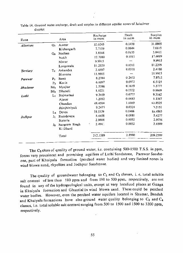
Table 14. Ground water recharge, draft and surplus in different aquifer zones of Jaisalmer
district
Recharge Draft Surplus
Zone Area in mcm in mcm in mcm
Alluvium QI Asutar 32.0243 0.1438 31.8805
Kishangarh 7.7159 0.0644 7.6615
Qs Nachna 3.8566 0.0155 3.8411
Nokh 17.7080 0.1011 17.6069
Murar 9.9915 9.9915
Longewala 11.2520 0.0311 11.2209
Tertiary T2 Askandra 2.4497 (J.0311 2.4186
Biluvana 11.9915 11.9915
Pare war PI Sanu 8.2384 0.2672 7.9712
P2 Karia 6.6097 0.0972 6.5125
Bhadasar Bdl Myajlar 1.5396 0.1619 1.3777
Bd2 Dhaneli 1.0221 0.1552 0.8669
Lath; LI Rajmathai 9.3'J39 0.0777 9.3162
Ajasar 1.2052 0.0485 1.1567
Chandan 48.4594 1.6069 40.8525
Jhinjhiniyali 9.2475 0.0324 1.2151
L2 Devra 18.5329 0.0466 IRA863
Jodhpur Jl Ramdevera 5.4458 0.0181 5.4277
Rataria 2.9808 0.0052 2.9756
J2 Sangram Singh 2.494 ~ 0.0052 2.4889
Ki Dhani -------_._--------------
Total 212.1589 2.8990 209.2599 ----------------------
The C3 class of quality of ground water, i.e. containing 500-1500 T.S.S. in ppm, forms very prominent and promising aquifers of Lathi Sandstone, Parewar Sandstone, part of Khuiyala formation (pelched water bodies) and very limited zones in
wind blown sand, rhyolites and Jodhpur Sandstone.
The quality of groundwater belonging to Cl and C2 classes, i. e. total soluble salt content of less than 180 ppm and from 180 to 500 ppm, respectively, are not found in any of the hydrogeological units, except at very localized places at Ganga in Khuiyala formation and Ghantial in wind blown sand. These could be perched water bodies. However, even the perched water aquifers located in Shumar, Bandah and Khuiyala formations have also ground water quality belonging to C3 and C4
classes, i.e. total soluble salt content ranging from 500 to 1500 and 1500 to 3200 ppm,
respectively.
55
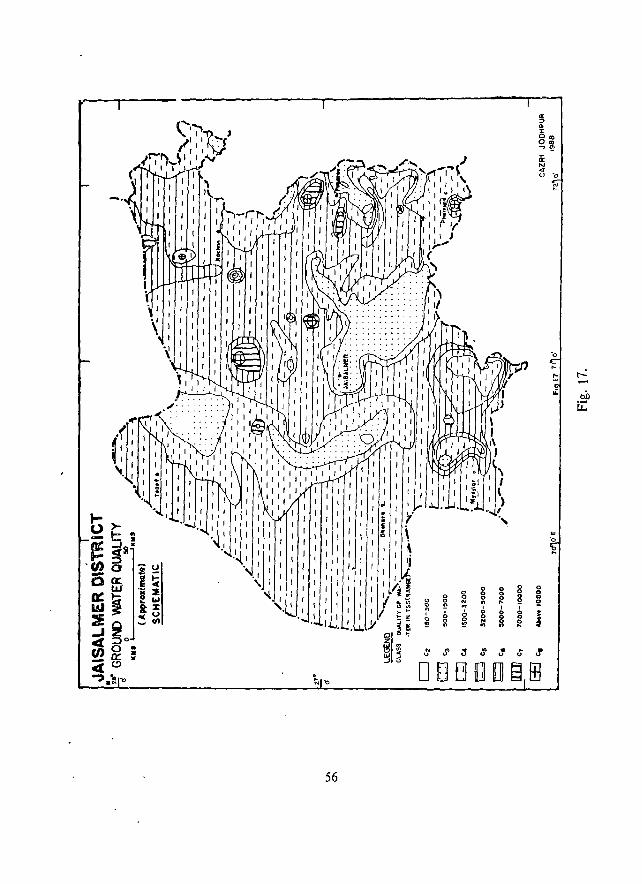
I. ~ 0
0 () I I ....
0 0 0 I J:,! 0 N ., 0
'" , I ~ E 0 ~ 0 " ,
0 0 ,
0 0 N
I I ~ ~ 0 0 ~ ., !!! " Y "I i ~ ., ~ ~ '" .1 "
.. " u
U w -'
0 D f3 .J "
56
rI'
0 0 0 ()
~ 0 ... I I
0 § 0
~
• ... " "
[] ~
0 0 <> !! ; J
. "
ill
N ,
·0
;:::
!:
..:
.....:
00 u:
CHAPTER IX
MINERAL RESOURCES
Iaisalmer district has considerable reserve of gypsite/gypsum, clay, phosphate and limestone, which are being quarried since long. The district has also been explored for natural gas and petroleum reserves by the Oil and Natural Gas Commission (ONGC) and Oil India Ltd (OIL) with some positive indications for availability of natural gas.
Limestone: The limestone deposits of the district are associated with the laisalmer limestone and Khuiyala Limestone. The former forms ridges, mounds and hillocks near laisalmer, from Pithal to Hamira and lethwai, near Amar Sagar, etc. The Limestone bands extend over 100 kms in NNE-SS W direction. The total thickness varies from 15 m to 145 m. The Khuiyala Limestone forms.an arcuate shaped hill range to the west of Habur.
The Iaisalmer and Habur Limestones found their places as ornamental building stones due to their colour and abundant small fossils.
Clay deposits: Pockets of clay occur within Lathi Sandstone and Mandai Sandstone at Chhor and Mandai, respectively. A clay bed of] to 2 m thickness occurs at Chacha. It appears to be the weathered product of an impure dolomite. This clay is used as a filler and is being quarried extensively.
Phosphorite: Phosphorite or rock phosphate associated with limestone, chert, black shale and sandstone has been located at Birmania. These phosphatic rocks are calcareous or arenaceous· Phosphate pellets have also been reported in the Baisakhi Shales near Rupsi and Nibh Dungar. But the phosphorite deposits were not found to be of commercial grade as their PzO(j content ranges from 5 to 20 percent only in Birmania deposits.
Gypsum: Gypsum is extensively quarried near Mohangarh where it is found at shallow depth. Selenite associated with gypsite is also found in the Mohangarh area, The entire production from Mohangarh quarries is used by the Fertilizer Corporation of India.
Oil and Natural Gas: Extensive exploration in the northern and north western parts of the district, near Asutar, Ghotaru, Kishangarh and Sadhewala has proved the existence of favourable structure for natural gas. In some of the bore holes drilled by ONGC near Ghotaru, commercial gas has been found. .
57
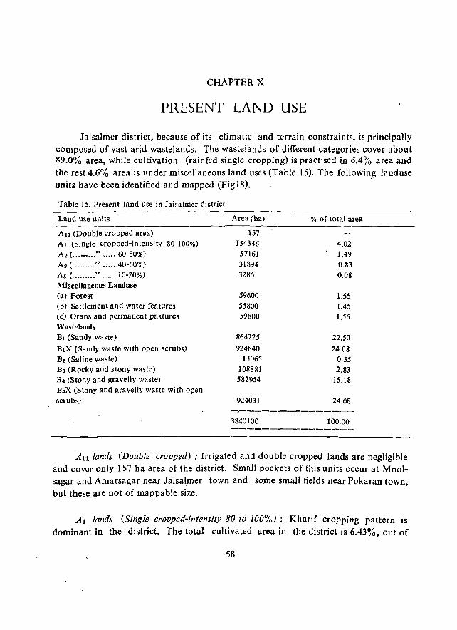
CHAPTER X
PRESENT LAND USE
Jaisalmer district, because of its climatic and terrain constraints, is principally composed of vast arid wastelands. The wastelands of different categories cover about 89.0% area, while cultivation (rainfed single cropping) is practised in 6.4% area and the rest 4.6% area is under misceJIaneous land uses (Table 15). The foJIowing land use units have been identified and mapped (Fig 18). '
Table 15. Present land use in laisalmer district
Land use units Area (ha) % of total area
Au (Double cropped area) 157 Al (Single cropped-intensity 80-100%) 154346 4.02 Aa ( ...•••... " ...... 60-80%) 57161 1.49 A8 ( ......... " ...... 40-60%) 31894 0.33
As (. ........ " ...... 10-20%) 3286 0.08 Miscellaneous Landuse (a) Forest 59600 1.55 (b) Settlement and water features 55800 1.45 (c) Orans and permanent pastures 59800 1.56 Wastelands Bl (Sandy waste) 864225 22.50
BIX (Sandy waste with open scrubs) 924840 24.08 Ba (Saline waste) 13065 0.35 B3 (Rocky and stony waste) 108881 2.83 B4 (Stony and gravelly waste) 582954 15.18 B4X (Stony and gravelly waste with open scrubs) 924031 24.08
3840100 100.00
All lands (Double cropped) .' Irrigated and double cropped lands are negligible and cover only 157 ha area of the district. Small pockets of this units occur at Moolsagar and Amarsagar near JaJsal.mer town and some small fields near Pokaran town, but these are not of mappable size.
Al lands (Single cropped-intensity 80 to 100%): Kharif cropping pattern is dominant in the district. The total cultivated area in the district is 6.43%, out of
58
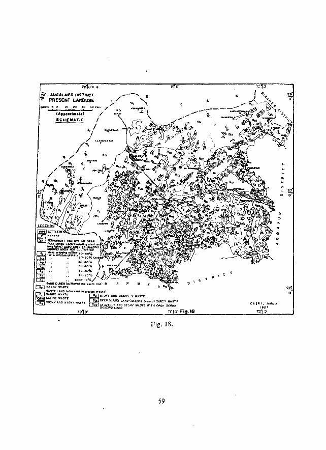
700'1- e
2" JAISALMER DISTRICT o PRES£NT LAHDUSE
Fig. 18.
59
o·
1 P. o \ OS
C. 1 \
II
e A VII 1, JodhpYr tec1'
72" O'
'"
28 O·
_ 27
o O·
zff (1
which Al unit covers 4.02% (154346 ha) area of the district. The unit is scatteredly (jistributed. There is more concentration towards the soulh-east, around Ramdevra, Odhaniya, Ujlan, Bhaniyuna, Sankra, Rajmathai, Badoragaon, Askandra, Jhinjiyali, Phuliya, Devikot and Khuri in the interdunal and Khadin areas. Around Jaisalmer the Al lands are mostly isolated small khadins.
A2 lands (Intensity 60-80%) : This unit covers about 1.5% (57161 ha) area of the district. Areas of tbis unit have been mapped towards southeast of Pokaran near Sakariya, Charno Ki Dhani and Lalpura, to the west of Sam near Meghwalon ki Dhani, and in some scattered pockets near Satto, Khetolai and Awai. The principal crops are bajra, moth, rnoong, guar and til. The unit is mostly covered with sandy hummocks and sand sheets. Production of crops is less here than in the Al unit.
A3 lands (Intensity 40-60%) : This unit occurs in the southeast towards Phalsund and Shergarh and adjacent to the districts of Barmer and Jodhpur. It covers about 0.8% (31894 ha) area and is mainly covered by sand sheets and dunes. Cultivation is done in 2, 3 or more years of rotation, but in the years of favourable rainfall there is good yield of bajra.
A5 lands (Intensity 10-20%) : This unit occurs around Lanela to the west of laialsmer and near Bharewala, BahIa, Panna, Madasar and Naukh in the northeast, covering only 0.08 % (3286 ha) area of the district. The terrain comprises high dunes and is cultivated only during the favourable rainfall years. Although these are marginal lands sometimes bajra is cultivated with musk-mellon and water-mellon. Such land is not recommended for cultivation.
Miscellaneous land uses: This unit includes forests, settlements (with water features) and orans or permanent pastures, covering 1.55% (59600 hal, 1.45% (55800 ha) and 1.56% (59800 ha) area, respectively of the district.
Wastelands: Wastelands of different kinds cover 89.02% area of the district. Although these lands are not generally suitable for cultivation, rocky and saline wastes are use~ for mining. Many of the wast'elands are grazing or pasture lands also.
Bl (Sandy waste): This comprises 22.5% (864224 ha ) area of the district. The major occurrences are in the north, no(thwest, northeast and southeast, where stable and unstable dunes with or without vegetation and sandy undulations are dominant.
B1x (Sandy waste with open scrub lands): These are also sandy wastes, but are covered with scattered shrubs and wild grasses which, however, do not survive for more than a few mon ths after the rains. This unit covers 24.1 % (924840 he) area of the district, and inculdes undulating sandy plains, interdunal plains and medium to small' dunes. It includes an area of more than 550 sq. km from Sultana to Asutar
60

where Vlsiurus sin_/icus (Sewan grass) grows naturally and provides ample fodder to
livestock of the dist rict.
B3 (Saline waste): 1 he major saline ranns like Mitha and Khara ranns, Kanod ka rann. That ka rann, Jhalariya ka ran n, Pokaran ka rann and Lawan ka rann are included in this unit. These are saline flats and not suitable for cultivation, but often their margins are used for grazing. Some rallflS are used for extracting salts. This unit covers 0.35% (13065 ha) area of the district.
B3 (Rocky and stony wastes): These are the hills and the sloping hill sides or pediments, mostly in laisalmer tehsil, and covers about 2 84% (108881 ha) area of the district. The major occurrences are near Lanela, Dedha, Damodara, Rupsi, Kanod
ka rann, Gomat and west of Bhaniyana.
B.J. (Stony and gravelly wastes): This unit occurs with tho;: B3 unit, especially in the foothills and associated gravelly lands and covers 15.2% (582954 ha) area, especially around Damodara, Rupsi, laisalmer, Lathi, northeast of Pokaran, Dedolai and Rathra.
B4X (Stony and gral·elly wastes with open scrub lands): It occurs in a 'Jeit between Jaisalmer, Mohangarh and Ramgarh and around Pokaran, Devikot and Ludrava, covering about 24.% (924031 ha) area of the district. It is a magra land for pasture and grazing. Although agriculturally waste it provides grass for the livestock.
Khadins: More than 500 khadins are located in the different isolated depressional areas surrounded by magra lands, and cover about 12500 ha area. When the khadins become dry after the rains, jowar, wheat and gram are grown in their bed without irrigatIon. In few cases like Rupsi and Bhuj khadins of laisalmer tehsil, the water stored in the upper khadins is supplied by channels to the lower khadins for cultivation. In the year of adequate rainfall almost all the khadins are .;ultivated. The larger khadins are at Bhuj (1600 ha), Oaiya (800 ha), Komal (800 ha), Jaitsar (L60 ha), Patan (143 ha), Olabundh (125ha), Saran (lao ha), Novada 1(96 ha), Ugata (80 ha), Mungri (80 ha), Sagra (76 ha), Barkhanwala (73 ha), Kansi I (88 ha) and Lunakhurd (83 ha). These khadins are highly productive. It is reported that in the years of favourable rain, IOta 14 quintals of wheat per hectare have been produced by the farmers. These khadins are the important sources of rabi crops without irriga
tion in this t!istrict. The names of the khadins do not necessarily reflect [he names of the villages, nor do all the khadins exist in the vicinity of the village settlements.
61
CHPTER Xl
SOCIO-ECONOMlC CONDITIONS
Out of the 462 inhabited villages of Iaisalmer district, about 7 percent villages were randomly selected for socio-economic investigation.
Enumeration of all the households of the villages was done and the households were further stratified according to various caste groups. From each caste stratum 10 percent of the total heads of households were selected and 547 schedules were filled in through random sampling procedure. Relevant secondary data were also collected from various available sources, i.e. census reports, records at Iaisalmer Tehsil office and at the district headquarters.
Demographic and social aspects
Over 80% of the respondents expressed preference of male child, rather than female child, to increase the earning members, for support in old age, for socioreligious requirements, patrilineal pattern of societ y and to gain higher social status. About one fourth of the respondents preferred small size of family with 1-3 children, and over one third preferred a medium size of family with 4-5 children. More than 40%, however, preferred a large family with more than 6 children for economic benefits and security. Maximum number of girls (60% to 100%) were married during childhood age (below 18 years). The age of marriage ranged from 5-18 years in a Rajput dominated village and 2-20 years in a Sindhi Muslim dominated village.
The overall growth rate of population increa~ed by 221.75% during 1901-1981. During 1971-81 the district recorded the highest growth rate of 43.4%, as compared to 36.3% in Rajasthan State. The chief reasona were in-migration of population with the introduction of Indira Gandhi Canal, influx after the 1971 Indo·Pak war, change in social values and urbanisation and tourism. In addition, customary practices of early marriage and remarriage in lower castes like Meghwals and Muslims, illiteracy, especially among the female members, high regards for a married person and belief in more hands for higher income in a family were the contributing factors.
The district is chiefly inhabited by pastoral communities and is dominated by Rajputs, Sind hi Muslims and Meghwals, followed by few Malis and other servicing castes in Iaisalmer Tehsil. Non-existence of other servicing castes related to agriculture is due to less complementary functions of the predominant livestock rearing castes in
62
the area. The Rajputs and the Sindhi Muslims comprise more than 'th ree fourtl. of the total households and inhabit the dune and inter - dunal plains. The Purohits, Paliwals, Brahmins, Malis and a sectarian group of Bishnois comprise more than 45% of the households, inhabiting dunes and buried pediments. Meghwals, Suthars and Kumhars, the traditional crafls households, inhabit alluvial plains and buried pediments, while other caste groups occupy rocky and buried pediments, alluvial plain and saline depressions.
Caste composition revealed predominance of Rajputs (80%), followed by others (20%)in the rocky-cum - buried pediment. In sandy buried pediments Rajputs (50%) and others were numerically equal in proportion, whereas in tlie sandy undulating units Sindhi Muslims (100%) were the only inhabiting community. Supporting castes to Rajputs were Bheel and Sind hi Muslims in rocky areas, while socio-religious castes (Swami, Gurda), occupational (Suthar. Meghwal) and others (Darji, Sindhi Muslim) were supporting the Rajput community in sandy buried pediments. No supporting caste to Sindhi Muslim was found in sandy undulating areas. For agro-livestock services Sindhi Muslims depended on occupational castes of the nearby villa~es.
Joint family system was dominant in Jaisalmer district. Of the households surveyed, 57% were found to be joint and 43'% nuclear households. Low density ~f population, scattered settlements, and extended family clans compelled the villagers to live jointly for security. Imbalanced male·female ratio, i.e. 830 females/1000 m'lles in 1981, late marfiag~ among males because of prevalence of high bride price and exchange marriage system are also respon~ible. Moreover, livestock rearing requires more number of persons which a joint family can provide.
Literacy rate is extremely low and almost nil among the female rural population. In rural sector the overall literacy rate was about 10%, while among males and females it was 17% and less than 2%, respectively during 1981 census.
The settlements were compact, scattered (dJlOni settlement) and compact-curn
scattered. Of all the households surveyed, 47% resided in compact and 42% in scattered settlenletlts. More than 10% of the household were in compact settlement during non-cultivating season and in dhani during cultivating season. In village Sankra of Pokaran tehsil hardly 10% of the total households lived in the village core, and 90% resided in dhanis. The distance of dhani settlement from the village core varies from 0.5 to 13 km.
Man-land. rela tionsbip
The land utilization statistics (1983 - 84) of Jaisalmer district indicate a very high proportion (76%) of barren and culturable \\ astclands. The uncultivable lands accounted for 14%area and comprised of forests (0.5%), usar and uncuItivable land
63
_(9%), land used for purposes other than cultivation (1.6%), and perlnanent pastures and other than cultivation (2.8%). Hardly 8% of the total area was under rainfed cultivation. Agriculture is followed by only one fifth of the total population as compared to about three fourth in other districts of the desert. On an average a household of laisalmer area possessed the highest size of landholding (10 ha) with lowest number of fragments (2), as compared to the situation in other arid districts of Rajasthan. Among the different castes a household of pastoral community (Rajput, Sindhi Muslims) owned a holding of 19 ha; agricultural community (Bishnoi, Purohit, Mali anj Paliwal) oWll<!d 15 ha; craftsman's household (Suthar, Meghwal, Kumhar) owned 13 ha; others (M ahajan, Bheel, Na i, Sonar and Da rji), rendering services to village community, owned II ha and the socio-religious castes 10ha. Of the various kha~if crops grown in the district during 1983-84, bajra, followed by fodder guar, were the most predominant rainfed crops. About half of the total area under kharif crops was occupied by bajra and more than half by the fodder guar. Areas under pulses and other khari/crops were "Imost negligible because of drought. About 1.3% of the total area sown had RaM crops, grown under Khadins. Among the rabi crops wheat, oilse
ed crops and gram were dominant. Only 96 ba of land was under irrigated cultivation.
Animal-human relationship
Animal husbandry is the main occupation, engaging about half of tbe total earners. Livestock population in the district was 1616 thousand according to the 1983 animal census, or 6.7 per capita, the highest for the arid zone of Rajasthan. Sheep and goats together constitute about 80% of the total livestock, whereas cattle constitute 16%. Density of adult cattle units per 100 ha of permanent pastures (including other grazing lands) and cropped area was found to be 13, 50 I and 168,
respectively.
On an average a household owned 65 heads of total livestock, out of which 40 were sheep, 7 goats, 15 cattle and 3 camels and others. In sample villages the Rajputs owned highest number of liveslock (143) per household, followed by the Mali
'(74), Sindhi Muslim (71) and Meghwal (_2)~ Irrespective of the caste status, donkey
is kept as an ecological necessity. It is most widely used for carrying water from far off distances, as tramporter to khadins, for carrying newly born lambs and goat kids to far off grazing lands and for carrying household goods during migration.
Livestock migration was chiefly prevalent among agro-livestock rearing communities of the sample villages·. Sind hi Muslims, followed by the Rajputs, and the Rawna Rajputs practised sllch migration most. Castes like Meghwal, Darji, Gurda and Sadh also practised migration during droughts and famines. On an average a migratory herd contains 130 heads of livestock and 4 persons which include the owner, bis sons, relatives and village friends. The routes followed by their ancestors
are still followed, though many express difficulties.
64
The migration cycle takes 3 to 10 months' time and the distance covered varies from 30 km to 1500 km, both within and outside the State. The pattern was also noticed during the severe drought of 19805.
Cottage industries, crafts and other sources of livelihood
About 29.61 percent of the total enumerated caste households belonged to the craftsmen communities. Among the vairous castes Meghwals (78.83 percent) were engaged in spinning wool, wool weaving and leather craft, Kumliar (10 94 percent) in cultivatiqn and pottery and Suthars (20.21 percent) in craft of timber and woodwork. The craftsmen groups were closely associated with the agricultural castes than with the pastoral communities.
Crafts articles have a local market for 3 to 5 villages, covering the distance of 5 to 30 kms. The means of transportation and communication are the major constraints.
Wool weaving and spinning are the predominant cottage industries associated with sheep rearing in the area. On an average 16% of the total surveyed households was engaged in wool spinning and weaving in the district. This being their chief subsidiary, supplements their economy to the extent of Rs. 2390/- per household per annum.
Leather work, a subsidiary craft industry, was followed by about 7% households. On an average a household earned Rs. 1666/- per year.
The income generated from the crafts per household was carpentry: Rs. 6,722, leather and shoe: Rs. 2,923, spinning and weaving: Rs. 3,330, spinning of wool by the females: Rs. 1,250. In case of capital investment the carpenter and the shoemaker invested Rs. 4,0.00, whereas other craf~smen invested Rs. 100 to 300 annually.
Due to socio-cultural transformation and technological advancement the traditional anisan crafts are dwindling. More than 50% of the households of Meghwal community, traditionally engaged in leather work, have discontinued their shoemaking occupation. However, w;th the introduction of Khadi Gram Udyog, wool weaving and spinning have gained popularity. Irrespective of caste status, wool spinning is done by the females of households to supplement their earnings. Carpentry h·as received a setback. The other sources of livelihood are camel cart driving, casual labour in stone mines and masonry works, and government and private services. Mean annual income per household, from these sources was about Rs. 1480. On an average a housholde earned the maximum from casual labours during a year.
Rural credit and indebtedness
Indebtedness is widespread among the rural population. Unlike other arid districts, laisalmer district is significantly less indebted, perhaps due to the higher
65
income stability of livestock breeders. The loans seem to be incurred for little productive purposes (buying of seeds, fertilizers, tractors, animals), but mainly to meet daily domestic needs in scarcity periods, or for socio-religious purposes.
On an average more than half of the surveyed house holds (57%) were indebted and their extent varies from 41% in buried pediment-hill-rocky structural plains complex to 79% in older alluvial and sandy undulating plains. The extent of overall indebtedness per household ranged from Rs. 2080 to Rs. 5641 per year. The average indebtedness per household in the sampled villages was Rs. 3944.
Institutions of credit
The principal public credit institutions in the district are the primary credit cooperatives for short-term loans and the land development banks for long-term loans both of which have performed quite poorly in the area. The reasons of poor performance are their refusal to give loans for non-productive purposes and their credit procedures, which are totally unadapted to the peculiarities of arid zone agriculture.
Comparative advantages al.d disadvantages reported by the villagers about the traditional and modern agencies engaged in rural credit and indebtendess are given below.
(a) Due to scattered form of settlements, banking institutions located at far off places, especially in towns or in Panchayat S"miti or Tehsil Headquarters, are not easily accessible. (b) Difficulties are faced to cope up with the banking formalities for getting loans. (c) Village money lenders are easily approachable as and when necessary for getting loans. (d) It is easy to mortgage gold/silver ornaments with the village money lenders, rather than the banks. (e) Bank recoveries are in cash, whereas the village money lenders postpone recovery during droughts or famines. (0 Village money lenders provide very long term loans, (g) To mortgage a land is considered a social stigma. (h) Banks keep secrecy of the borrowers, whereas the village money lenders keep it open. (i) Illiterac~ of the people puts the borrowers sometimes
in trouble.
66

CHAPTER XII
STATUS OF LIVESTOCK
Trends of livestock population in Jllisalmer district
During the last 81 years since 190 I laisalmer district experienced 10 mild, 22 moderate and 10 severe droughts. The harsh climatic conditions and its location in one of the remotest parts of the country have allowed the breeding and mUltiplication of only those animal types which can withstand the rigours of the environment, besides ensuring the maintenance of the purity of the breeds, ihis is mainly the reason why the animals presently found in laisalmer district are not only among the hardiest, but also of the purest types in the country.
According to the 1983 livestock census laisalmer district harbours 1.6 m heads of livestock. There was a 92% increase in total livestock popUlation between 1956 and 1983 (Table 16). The district had only 0.85 m heads of livestock in 1956. During this period, minimum change was recorded in the number of donkeys and ponies (+3.0%), followed by cattle (+ 12.0%). The maximum gain of 153% was among the camel popUlation, In 1956, the district supported 0.23 m cattle, \\ hile in 1983 the number increased to 0.26 m heads. The cattle population of laisalmer district has been widely fluctuating since 1956 (Table 16). Between 1956 and 1961 there was a 26% increase in cattle population, followed by a 17% increase during 1961-66. The cattle population then decreased drastically by 81 % during 1966-1972, followed by massive increases during 1972-77 (89% ) and 1977-83 (111%). The recorded reduction in cattle population during 1966 and 1972 was mainly due to the heavy losses caused
by severe droughts.
Since 1956 the buffalo population in the district fluctuated more than the cattle popUlation. It had slightly decreased (3%) during 1956-1961 and registered some 3% increase during 1956-1966. Later on the buffalo population was drastically reduced (16%) during 1966-1972. During 1977-1983, the buffalo popUlation increased by 63%. While most livestock species in the district recorded increase in their number during 1956-1983, buffaloes were reduced in number (23%) during the same period, the highest reduc tion (61.1 %) having been recorded in the population of buffalo-bulls, followed by she-buffaloes (25.7%). However, during this period the number of buffalo calves increased by 33.8%.
The district had a goat popUlation of 0.19 m in 1956, which rose to 0.29 m in 1961 and 0.30 min 1966. A series of fluctuations in goat number followed: 0.19 m
67
.g Vi :a .... u E c; '" ~ c u
.§
'" ::I CIl C e
ONO""O 1"-00<;>\0000\ ~ Nv)cciNM....:v)~ciN~·r--:r-.j ;::
N ~~~~('f')NN I/')
68
o N
o on 00
c; OIl -._ 0
t:l..f-o
CIl u ::I c; u > U .... U ::I
..c 0 f-oCll
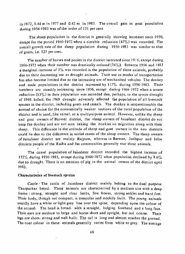
in 1972, 0.44 m in 1977 and 0.42 m in 1983. The overall gain In goat population
during 1956-1983 was of the order of 121 percent.
The sheep population in the diStrict is generally showing increases since 1950, except for the period 1966-1972 when a sizeable reduction (47%) was recorded. The overall growth rate of the sheep population during 1956-1983 was similar to that of goats, i.e. 121 per cent.
The number of horses and ponies in the district increased since 19.' 6, except during 1966-1972 when their number was drastically reduced (76%). Between 1956 and 1983 a marginal increase of 3% was recorded in the population of these animals, probably due to their decreasing use as draught animals. Their use as modes of transportation has also become limited due to the increasing use of mechanised vehicles. The donkey and mule populations in the district increased by 117% during 1956-1983. Their numbers are steadily increasing since 1956, except during 1966,1972 when a severe reduction (83%) in their population was recorded due, perhaps, to the severe drought of 1969. Infact, the 1969 drought adversely affected the population of all livestock species in the district, including goats and camels. The donkey is unquestionably the animal of choice for the economically weaker sections of the rural population of the district and is used, like came), as a multipurpose animal. However, unlike the sheep and goat owners of Barmer district, the sheep owners of Iaisalmer district do not keep the donkey and are not seen taking the donkies on migration along with their sheep. This difference in the attitude of sheep and goat owners in the two districts could be due to the difference in social castes of the sheep owners. The sheep owners of Jaisalmer district are mainly Rajputs, whereas in Barmer, Jodhpur and Ialor districts people of the Raika and Jat communities generally rear these animals.
The camel population of Jaisalmer district recorded the highest increase of 153% during 1956-1983, except during 1966-1972 when population declined by 8.6% due to drought. There is no mention of pig in the animal census of the district uptil 1983.
Characteristics of livestock species
Cattle,' The cattle of Iaisalmer district mainly belong to the dual purpose Tharparkar breed. These animals are characterized by a medium size with a deep frame: strong, straight and clear limbs, fine bones, strong ankles and hard feet. Their body, though not compact, is muscular and stockily built. The young animals usually have a white or light grey line over the spine, depending upon the colour of the animal. The head is broad, w'ith a straight, bulging forehead and a long face. Their ears are medium to large and horns short and upright, but not coarse. Their legs are short. strong and well built. The tail is long and almost reaches the ground. The coat colour in these animals generally varies from white to grey. The average
69
height of the bull is from 131 em to 13 7 cm and that of the cow is from 127 cm to 132 cm. Bullocks of the Tharparkar breed are good draught animals and the cows are relatively good milk yielde~s. The average daily milk yield from a Tharparkar cow is only 2.3 to 3.2 kg which may increase to 4.5 kg during the monsoon. Stall-fed cows may yield upto 11.2 kg milk/day. The average milk yield from well maintained stall-fed Tharparkar cows in laisalmer district is 1,361 kg during the lactation period of 6 to 8 months. In some cases it is as high as 2,268 kg.
Cattle of the Rathi breed are also found in the north-eastern part of the dist~ rict. It is a milch breed. The Rathi cows are good dairy animals, but the bullocks are low and relatively poor in draught power. Rathi cattle are medium sized, with a heavy head and moderate-sized, coarse, small, thick horns. Thry have a comparat ively broad face with a heavy hump and dewlap, and a pendulous sheath. They have dropping ears and a deep, compact frame of rounded quarters. The legs are short, massive and wide and the udders are quite capacious. The animals are wedge 5hllped,
with an average height of 125-132 cm in the case of males and 109 cm to 127 em in the case of females. The colour of Rathi cattle varies from red to dark red, sometime with a white spot on the dewlap and the udder and even on the body. A combination of red and white or black and white coat colours is also found. The average milk production of Rathi cow ranges between 6.5 and 8 kg per day A well maintained, stall-fed Rathi cow can yield upto 13.6 kg milk per day, with an average production of 1,588 to 1,814 kg of milk during a lactation period that lasts generally for 10
months.
Considering the importance of laisalmer district as the principal source of germ plasm for Tharparkar breed of cattle, Rajasthan Government established, in 1964, a 250 ha Cattle Breeding Farm at Chandan for the improvement of Tharparkar cattle. Genetically pure Tharparkar bulls are bred here, maintained and distributed among the farmers.
, Goats: Goats constitute about 26% of the total livestock population of the district and belong mainly to the long, black haired, meat type Marwari breed. These are not good milk yielders'. Goats of another meat type, the Lohi breed, are also found. The Marwari goats of laisalmer and other arid districts of western Rajasthan, are in great demand in other parts of the country. Goats from the district are regularly transported to Bombay for slaughter.
Sheep: Sheep in laisalmer district mainly belong to the laisalmeri breed and constitute about 54% of the total livestock population of the district. laisalmeri sheep is a heavily built animal, with a black face and characteristically long ears and a roman nose. The average body weight of the ewes is 29 kg to 30 kg and that of rams 3'2 kg. The average per capita wool production is about 2.12 kg per annum. The
70
wool, which is white in colour, is of medium grade, though some flocks produce fine grade wool as well. Sheep are clipped twice a year.
Buffaloes: Because of their high water requirement buffaloes constituted only 0.1 % of the total livestock population of the district during the year 1983.
Camels: The camel is Perhaps the most useful domestic animal in the district. The Iaisalmeri camels, forming a specific breed called Jaisalmeri, are considered to be fast runners and are famous for their speed, hardiness, endurance and easy paces. There are lighter in weight and are also lighter in colour than the Bikaneri camels. Iaisalmeri camels. unlike the Bikaneris, do not have a bunch of black hairs on the inner side of pinnae. nor do they have the big hairy eye lashes, typical of the Bikaneri camel. However, these animals have a long cluster of hairs at the lOWer part of the neck, which is generally absent in the Bikaneri camel. They can go over long distance without food or water, subsisting for days on a little unrefined sugar (Jaggery) and alum which are carried in the saddle bags. The better animals of this breed are smaller and finer in head and neck than the ordinary camels of western Rajasthan, and can cover 129-161 km during a single night if the need arises. The camels are used both for pleasure rides and for a host of useful purposes like ploughing and harrowing the land, for bringing home the harvest and for carrying wood and water. Camel milk is also consumed by the rural population. Its hair is used fer making Durris (rough carpets) and ropes and the hide for making shoes.
Donkeys: Among all the Ii vestock types of Iaisalmer dist'iet, the donkey, perhaps, makes the highest contribution as the beast of burden, carrying a variety of loads like \vater, fodder and fuel wood and providing transportation to the human popUlation. They are also_ used for ploughing the fields during the monsoon.
/
Animal products-based cottage industries
Since sheep and camel rearing are important in the district, the wool industry here is provided with a rich resource base. It is the ollly cottage industry worth the name in the district.· Unprocessed wool is generally exoorted out of the district and processed wool is used for making shawls or lois, blankets, carpets and namdahs. The articles are made in two shades. white and black. Camel and goat hairs are also used for making carpets and large bags for carrying fodder. Ropes made of camel and goat hairs are also in demand.
Livestock fairs
Although no cattle fair of importance is held in the district, yet a couple of local cattle fairs are arranged by the Pancbayat Samities. Olle such fair is held at Naukh during April-May. Animals are also brought to the Ramdeora fair, for purchase and sale of camel, bullocks and cows.
71
Animal diseases
One of the most common livestock diseases in the district is Avitaminosis, caused by the non-availability of good pasture or green fodder. Foot and mouth disease is also common· Mastitis in cattle is not very common.
Fodder situation
During the days of princely administration, Jais:\Jmer kept reserved tracts of grass to meet milder fodder scarcities. Some such tracts were at Dawa, Khaba and Devikot. Arrangements were also made to store enough hay and fodder. Presently, fodder are grown generalJy in areas where tube well facilities are available. The major fodder crops include guar (Cyamopsis tetragonoloba), rizka (lucerne), jOlVar (Sorghum), and bajra (Pearl millet), growing mainly in Pokaran tehsil. According to one estimate, during 1963-64, 1964-65, 1965-66, 1966-67 and 1967-68 fodder crops were grown on 20,136 ha, 24,414 ha, 21, 070 ha, 20,081 ha and 22,573 ha of land, respectively in Jaisalmer district.
Considerable efforts have been made by CAZRI to mitigate the fodder scarcity conditions in laisalmer district and to improve and nurture the natu'ral rangelands. Apart from the Government's and the farmers' efforts to mitigate the fodder scarcity conditions the extensive areas of naturally growing Lasiurlls sindi(l/s provide permanent pasture.
The major constraints for utilising such grazing areas are lack of water and shade. The fodder, when its requirement is maximum during summer, becomes highly fibrous (neutral detergent fibre content: 79.5%) and may contain as little as 2.7% of
'crude protein. During the summer of 1986, the cattle owners of Shiv, Gunga, Deva and Jbinjhiyali villages took their animals to Pali-Digga and let them loose on this pasture. As no water sources were available near this grazing area, the cattle owners were forced to take their livestock every alternate day to the nearest watering point at Sultana village, about 12-20 km from tbe various cattle camps. According to one estimate, during the summer of 1986 about 40,00.0 cattle camped in this area and in some of the cattle herds the mortality rate was as high as 45-55 per cent during their stay in this grazing area.
During the drought year of 19B7, a total of 119 cattle camps were organised at various sites in laisalmer district and a total of 655, 775 heads of cattle were bene
fitted through these camps.
72
CHAPTER XIII
WILD LIFE AND RODENT PESTS
WHd Life
The district is an endless stretch of sandy plain intersper~ed with innumerable sand dunes and at places with rocky areas and hillocks. Due to the arid environment, it supports a very scanty vegetation and a low density of trees and shrubs which reflects upon the carrying capacity of land. Yet it is amazing that quite a variety of wildlife is found in this xeric environment. The Indian gazelle, locally known as Chinkara (G. gazella) is fairly common, whereas the desert hare (Lepus nigricollis) is sparsely distributed all over the district. The porcupine (Hystrix indica) occurs in the hilly habitat. The carnivores, desert fox (Vu/pes V. pusilla) and desert cat (Felis lyMca) are occasionally seen, but jackal (Canis aureus) and the wolf (Can,'!>: lupus) have almost vanished from the scene.
Among the birds, the most significant and spectacular species found in fair number in this region is the Great Indian bustard (Adreotis nigriceps). It is especially common in the western part of Iaisalmer and north western part of Barmer district. Part of the region has been declared as a Desert National Park. The Patridge (Franco linus pondiceriallus) , the common sandgrouse (Pterocle.s exustus) and few quails are the common species of wildlife interest. During the winter season several birds migrate into this region. Among them the Houbara (Chlamydotis undulata) and the Imperial sandgrouse (Pterocles oritendalis) are the main species of wildlife interest.
A number of reptiles inhabit the sandy plain. Among them the more important ones are the spiny-tailed lizard. commonly known as sanda (Uromastix hardwickii), the desert monitor hzard (Varanus grise us) and the venomous viper (Echis carinatus). In the sewan (Lasiurus sindiells) grasslands there is a great scope of conserving the wildlife species, if the grass can be maintained in green condition throughout the year by meagrely irrigating it through sprinkler.
Rodents
Rodents are a menace. They destroy standing food and fodder crops, stored foodgrains and other properties worth millions of rupees. In addition, they spread atleast 20 kinds of diseases among human beings. In the desert region their density per unit area is much higher than in any other habitat in India. The damages inflicted by the field rodents to kharif as well as raM crops, to grasses and to the tree
73
plantations make it all the more essential that adequat econfrol operations are adopted before sowing any crop or taking up any afforestation programme.
In Iaisalmer district a survey to study the species composition and habitat selection of field rodents were taken up in 4 major land types.
(I) Sandy Iwbitat: A community of Lasiurus silldiclIs--Cenchrus biflorlls and Bfepharis sindicus was recorded on this habitat which supports shallow soil, deposited either on gravels or on rocky substratum. Capparis decidua scrubs on such situations are evenly distributed, having a frequency of about 66 percent. The herbaceous ground flora had a comparatively high basal cover of 7.9 percent because of enclosure: Most of the rodent burrows were recorded from the sandy hummocks formed under Capparis decidua bushes. At the time of study a very low number of rodents was, however, recorded (trap index being 0.034). In an earlier study conducted in the same habitat a much larger number was recorded. It is worth mentionig that Meriorles hurrianae could not be collected even during 3000 trap hours in this habitat and only
three species of roderits viz. Gerbil/us gleadowi, G. n. indus and Flinamblilus pennant; were collected, the latter being collected in the traps situated near Tecomella undul
a/a trees.
The species composition was found to be as follows:
Species Funambu/us pennanti Gerbil/us nanus indus Gerbil/us gleadoll'i
• Meriones hurrianae Rattus g/eadowi
Percent frequency 33.3 33.3 33.3 Few Few
(2) Rocky habitat: In the studied rocky area Cymhopogon jawarancusa-Eleusine compressa-Oropetium thomaeum formed the main plant community, associated with Commiphora wightii plants. The soil depth was almost nil. The number of rodents tr~pped here was low and only 4 R. C. cutchi<:us were trapped. This may be due to the extreme drought 'prevailing at the time of study and the thin veneer of soil
mantle.
The species composition was found to be as follows:
Species H),strix indica Rattus c. cutchicus
Percent frequency Rare 100
.(3) Grallelly habitat: The vegetation in the gravel plains was found to be very sparse and was chiefly composed of Salvadora oleoides, Commiphora wightii and
74
Acacia senegal. The other components were Tephrosia purpurea and Capparis decidua and at certain localities Acacia jacquemontii and Prosopis cineraria. Rodent population wa~ found to be very low in this habitat. The species, collected in this habitat, were M hurrianae, Talera indica. R. GleadolVi and Mus platyhrix.
(4) Village complex: Ruderal habit'at (village complex) can be seen on any landform, mainly depending upon the availability of water and forage for human and livestock population. Typical plants in this habitat are Azadirachta indica, Prosopis cineraria, Tamarindus indica, FicliS religiosa, F. bengalensis, Ficus relusa, Salvadora oleoides, Zizyphus mauritiana, etc. which are planted for shade and to serve as top feed for the animals during the periods of fodder scarcity. Hedges around the hutments and crop fields are chiefly composed of dried twigs and thorns of Zizyphus nummularia, Prosopis juliflora and Calligonum Polygonoides which serve as the outer boundary wall. Adjoining to these village hutments and occasionally in the village itself, crop fields are found where rain fed crops like millets and legumes (Phaseolus aconitifolius, P. aureus, Cyamopsis tetragonoloba) and oil ClOpS like sesame are mainly cultivated. Under such conditions the rodents were trapped in the village outskirts, particularly along the hedge lines.
The species composition was as follows:
Species G. gleadowi Tatera indica Meriones hurrianae
I
75
Percent frequency 78.0
7.0 14.0
CHAPTER XIV
MAJOR LAND RESOURCES UNITS
CHARACTERISTICS AND ASSESSMENT
The mapping, evaluation and correlation of the data generated in respect of different land attributes within the district led to the recognition of certain patterns of homogenity in the spatial distribution of the different attributes (resources), and hence, of eertain units which have been named as the Major Land Resources Units (MLRU). Each of these has its own set of characteristics in respect of geomorphology, soils, land capability, vegetation, surface and subsurface water, land use, etc., and also certain problems and potentials.
Ten Major Land Resources Units have been recognised and mapped within the district (Fig. 19). Their characteristics and assessment are as follows:
UNIT
1. Hills (360.0 sq. km)
Geomorphology: Formed of sandstone. limestone, granite and rhyolite; shape conical, monoclinal and flat- topped; almost no talus; obstacle dunes against some; long, rectilinear slope; faceted in areas of hard cap: very few channel.
Soils and land capability: Rocky; VIII. . .
Vegetation: Salvadora oleoides, Capparis decidua, Aristida, Oropetillm thomaell';'.
Surface water: Insignificant infiltration; run-off better than in sandy areas, but not sufficient.
Ground water: Nil
Present land use: Mainly rocky waste.
Assessment: Suitable for quarrying of aggregate resources. Runoff from the rocky slopes could be collected either in the foot-hills or beyond.
76
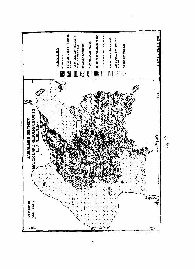
~ II <II
~ I! C ~ Z E '" u ::I! ..
~ 01/) 1'1 .. ~ .... C ..
Iii "' .... :i ~ 5' 0 0. .... E 3
2 ~:r :II z loS ~ ~ ...
olf.:l ~ '" UJ !J ~5 ~ .. a: .... ....l ,_ .... ,~. ~
'" % ~ ~:il .... ~ "- ..J
"'''' .... 0
UJ
~ ,_- .. u w
....lz Z z- :.::z: ~ Ii ::; .. ....l c><C ~i '" ~ _..J a: .... <C ..J
:rOo '" "- I/) IL
I ~ I r;] . lIm I 11 [;j
77
.:. '" !!: .. z
'" It ~ '" ~
... I! .. !!: ill
" '" '" '!l ... " Q '" a.
!i t '" <>
'" ... o'!' z <> ~ ~ .. ~ ",It .. I/)
!ill [J lim . . .
.. <II ~
II: ::> .. ~ II: ...
!! "
Ii: 0
";::
" VIONI
",~rsi~
"" '"
0-
oil l:i;
2. High level rocky structural plains (1314.6 sq. km)
Geomorphology: Mostly with south facing escarpments; 10 _3 0 long dip slope towards NW; channels mostly along dip slope; parallel to dendritic pattern; karsting on some limestone hamadas, wind erosion is dominant.
Soils and land capability: Miscellaneous shallow, gravelly/locky; VIII, sh, r.
Vegetation: Euphorbia mduci/dia, Acacia senegal, S oleoidcs, Ccn:n,iphora lrighlii, Aristida, O. thomaeum.
Surface water: Insignificant infiltration; run-off during occasional cloud-burst; b~tter potential along the long dip slope.
Ground water: Ni 1
Present land use: Mainly rocky/stony wastes with open grazing lands.
Assessment:' Suitable for quarrying of aggregate resources; catchments along the dip slope could be developed for harnessing the run-off from this unit more efficiently for khadin cultivation downslope. Commiphora wightii is severely degraded, especially around Jaisalmer, but has tremendous potentiality. Euphorbia and Acacia species need encouragement. The Eocene Khuiyala Limestone, forming the unit to the west of Habur, has excellent flux grade limestone reserve of about 350 million tonnes.
3. Rocky/gravelly pediments (1353.2 sq km)
Geomorphology: Flat, 0° to 10 slope; often armoured with angular, varnished fragments and/or a veneer of aeolian sand; very few shallow channels.
Soils and land capability: Rocky/gravelly, with occasional shallow, miscellaneous deposits; VII c, sh; VIII r.
Vegetation: A. senegal, Zizyphus nummularia, S. oleoides, C. decidua, Aristida, O. thomaeum, Dactyloctenillm sindicllm" Eleusinf compressa.
Surface water: Insignificant infiltration; better run-off potential during occasional cloud burst; numerous nadis, water available for 1 to 6 months.
Ground water: Generally not explored, but exploited in some cases of Lathi, Bhadasar and Parewar aquifers.
Present land use: Rocky and stony wastes with open scrub grazing lands.
Assessment: Degradation of scarce vegetation resource, especially through uncontrolled open grazing and destruction of shrubs for fuel, etc., are favouring faster sand movement along the margins of the sandy desert. Sedimentation in tlie nadis, especia-
78
Ily aeolian sand deposition, is a problem. To minimize the sand movement through this unit range care is necessary over it and in the surrounding sandy units.
4. Gravelly pavements (352.8 sq km)
Geomorphology: Slightly convex outline; I °_3 0 slope; surficial concentration of cleaved or subrounded quartzite and other cobbles and pebbles, mixed with sand; subsurface contact with parent formation is either direct, or through a finer, sandy layer.
Soils and land capability: Heterogenous gravelly soils; gravel-free solum has sand to loamy sand texture; reasonably good amount of plant nutrients; tendency to form crust; VII, sh.
Vegetation: C. decidua, Z. nummu/aria, Aristida, O. thomaewn.
Surface water: Moderately high infiltration, lesser than in sandy areas, but higher than in rocky units; many nadis.
Ground lVater: Exploited in Lathi Sandstone aquifer; TSS ranges from 500 to 3200 ppm; Av. depth to water more than 60 m.
Present land use: Gravelly wastes with open grazing lands.
Assessment: Suitable for quarrying of aggregate resources and pasture development.
5. Flat colluvial plains (10830.0 sq. km)
Geomorphology: Flat, 0°_1° slope; average colluvial depth 33 to 60 em, plains associated with' pediments dominated by 0.15 to O. 25 mm size near-surface sediments, alongwith parent rock fragments; gravels and pebbles dominate in pavemented areas; less of fluvial transport; slow in-situ weathering.
Soils and land capability: Generally medium to fine textured in areas associated with pediments 'and structural plains in the west; sandy loam to clay loam; good structural development; medium textured in pavemented areas of east; sandy loam; weak to moderately developed subangular blocky structure; medium to fine textured in Khadin areas; stratified soils, better aggregation and clod formation; sandy loam to loam and clay loam; IV, C, sh, s; VI c, s, sh.
Vegetation: S. oleoides, Prosopis cineraria, Z. nummu/aria, C. decidua, Tamarix dioica (in Khadin), Acacia ni/otica (in Khadin); L. sindicus, E. compressa.
Surface water: Slow infiltration; moderately high run-off potential; numerous nadis and tankas; khadin system of run-off harvesting for agriculture in favourable
79
-areas with appreciable soil depth and rocky catchment in the surroundings. Catchment size for khadins generally varies from 2.5 to 51 sq.km; storage capacity varies from 0.028 to 2.33 mcm.
Ground water: Lathi Sandstone, Bhadesar Sandstone and Parewar Sandstone provide the potential aquifers in most areas; Jodhpur Sandstone is the potential aquifer to the east of Pokaran and Ujlan. Depth to water more than 60 m in most cases, but between 15 and 40 m in the east. Most of the potential aquifers have water of less than 3200 TSS, while some have upto 5000 TSS. Unconsolidated Quaternary deposits along channels are the sources of perched water at fa vourable sites after occasional good rains; water tapped through shallow dug-wells (beries).
Present land use: Khadin cultivation in favourable locations through conservation of rain water-also a source of rabi cropping; otherwise usual monocropping of kharif crops in rotation; also permanent pastures (orans).
Assessment,' Most of the cultivated lands of the district occur within this unit. Although it contains a wide range of soil texture, the soil depth is a limitation almost everywhere. Traditional khadin system of ,cultivation in favourable areas has proved to be immensely successful, but requires better management, improvement and propagation. Permanent pastures are in various states of degradation; also there is shrinkage of their area, leading to further degradation of the marginal lands. Moderate to very high risk of aeolian hazard, especially along the margin of dunecovered and other sandy undulating areas.
6. Saline flat colluvial plains (65.8 sq.km)
Geomorphology: Flat, 0°-1 0 slope; morphological characteristics are same as in the case of flat colluvial plains. However, the surface is saline, mostly due to the nearness of the gypseous clay beds associated with the Baisakhi Shale formation (e.g. near Sirwa and Modha). Mappable areas are limited, although there are several pockets of such salinity within the rocky areas.
, Soils and land 'capability,' Generally fine textured soils; associated with pedimented areas; loam to clay loam; moderately developed subangular blocky structure; saline soil; VI sa, s, c.
Vegetation,' S. oleoides, Tamarix dioica, P. julijlora, Sporobolus marginatlls.
Surface water,' Slow infiltr"ation; moderately high run-off potential.
Ground water: Not very promising.
Present land use: Very poor monocropping of kharif crops in scattered locations; otherwise miscellaneous wastelands.
80
Assessment: These areas could be developed through forest plantation, especially through plantation of naturally occurring species of P. juliflora, S. oleoides, Tamarix dioica, etc. The limited soil depth and salinity/alkalinity are the major hindrances for agricultural development.
7. Flat older aJl!lvial plains (694.2 sq. 'km)
Geomorphology: Flat, 0°-1 ° slope; mainly along the dry beds of the Sukri and the Lik; average thickness over hard pan is 60 to 100 cm; medium to fine sands dominate; lime-coated riverine conglomerate is often the limit; problems of salinity·alkalinity in the south-east, as the Lik has its source in the ranlls.
Soils and land capability,' Moderately deep to deep sandy loam to loam, underlain by lime concretions and gravels; finer particles dominant in the subsoil; weak to moderately developed structure; IV c, VI c, s, gao
Vegetation,' C. decidua, Z. lIummularia, Calotropis pro cera, Aerva pseudotomentosa, L. sindicus, E. compressa.
Surface water,' Slow to moderate infiltration; numerous nadis and tankas. Khadin system of run-off harvesting for agriculture.
Ground water: Lathi Sandstone and rhyolite form the major aquifers; few cases of alluvium aquifer; Depth to water generally between 15 and 40 m; TSS ranges from 1500 to 50:>0; perched water along the channels are tapped in beries after the rains.
Present land use,' Monocropping of kharif crops dominate, intensity 60% to 80%; permarient pastures are fewer than in other units.
Assessment: Limitations of soil depth, salinity/alkalinity and adequate potable water preclude much development under the existing set-up. Deep ploughing with tractor has led to the problem of accelerated wind erosion in many parts (e.g. between Ramdevra an'd Loharki, near Bhaniyana), as monsoon rainfall is totally uncertain and SW wind energy is high, even in July-August. Yet, it contains some of the potentially good agricul tural lands within the district.
8. Sandy undulating plains (3051.6 sq. km)
Geomorphology,' Thick, undulating aeolian sand over either a colluvial surface (dominant), or sandy alluvium; 1 ~o 5 m high, mobile barchans, barchanoids and sand streaks are the major constituents.
Soils and land capability: Moderately deep to deep sand to loamy sand, underlain by lime concretions, gypsum layer, gravel Ot rock, generally no stable str'ucture; fine sand in the substratum; VIc, s, sh and VII c, s, e.
81

Vegetation: Haloxylon salicornicum, A. pseudotomentosa, C. decidua, L. sindiclls, E. compressa.
Surface water: High infiltration; low runoff potential; many tankas with artifical catchment; few nadis.
Ground water: Lathi Sandstone provides the potential aquifer; depth to water varies from 40 m to more than 60 m; TSS ranges from 1500 to 5000.
Present land use: M&inly sandy waste; also used as open grazing lands.
Assessment: Very high risk of aeolian hazard. The low density grasses and shrubs are being excessively exploited near the settlements, leading to more deg~adation in those areas. In the north the unit has excellent coverage of natural Lasiurus sindicus grasses, but due to recurrent drought and absence of any range care practices much of it has become almost a dead stock. Yet, there is potentiality for development of
.natural grassland with minimum rar,ge care.
9. Sand dunes (17192.4 sq. km)
Geomorpho/flgy: Seven major types; the megabarchanoids of the south-west, the smaller barchans and other sandy streaks are mobile; others are relatively stable and vegetated, yet highly vulnerable; formation and movement related to dominant sw wind; mobile dunes and reactivated dune crests are dominated by 0.25 to 0.18 mm sand. Buried courses of the former Saraswati river beneath the June and interdune sediments in the west.
Soils and land capability: Light yellowish brown to reddish brown, very deep fine calcareous aeolian sand; no structure; poor moisture retention; VI c, s, e.
Vegetation: Leptadenia pyrotechnica, Calligonllm polygonoides, C. pro cera, A. pselldotomentosa, L. sindiclIs, P. turgidum, E. compressa.
Surface water: Very high infiltnition; almost no potential.
Ground water: Potential Quaternary alluvial aquifer beneath the dunes and interdunes in the west; depth to water varies from 40 to 60 m; TSS ranges from 3200
to 5000.
Present land use: Mainly sandy waste; also used as open grazing lands.
Assessment: Inspite of very high vulnerability the stable dunes can support adequate grass and shrub cover under undisturbed condition; this helps in reduction of the aeolian hazard. However, excessive exploitation of the resources near settlements and earthwork connected with 1. G. canal construction in the north and west have
82
created numerous mobile forms and associated problems. Programmes for stabilization of the dunes through plantation have now been taken up on a massive scale in the canal command area, especially along the main canal. Mobile dunes are most numerous in the western part, affecting settlements, roads, etc. but are transient in nature.
10. Interdunal plains (3061.0 sq. km)
Geomorphology: Most Iy flat and sandy undulating; few rocky; shape guided by orientation of sand dunes; dominant g_rain size varies from 0.12 to 0.15 mm. Buried courses of the former Saraswati river beneath the aeolian sediments in the
west; problems of aeolian erosion and deposition.
Soils and land capability: Light yellowish brown to reddish brown, deep to very deep fine calcar ~ous sand; no structure; also underlain by lime concretion, gypsum, weathered rock fragments, etc. at depth; IV c, VI c, s, e.
Vegetation: P. cineraria, C. decidua, C. poiygonoides, Z.l1ummuiaria, L. sindicus, H. salicornicllIn, A. pseudotomentosa.
Surface water: Infiltration rate variable according to the nature of the deposits; tankas numerous; also nadis, especially in flat and rocky interdunes.
Ground water: Most potential aquifer is the Quaternary alluvium III the west; depth to water varies from 40 to 60 m; TSS ranges Jrom 3200 to 5000.
Present land use: Mainly sandy waste; also monocropping of Kharif crops, especially in th\) eastern part; open grazing land.
Assessment: With the introduction of canal water many of the interdunal plains in the I. G. Canal command area will be transformed into good agricultural land~. However, the subsurface barriers, especially of gypsum hard pan or amorphous layers may encqurage waterlogging and salinity· alkalinity build·up and hence, may prove to be a deterrent factor in the near future. The terrain is also highly vulnerable to aeolian hazard. Hence, devegetation operation for agriculture or deep ploughing, without assured supply of water may lead to aeolian erosion and new mobile dune formation. The vast L. sindicus grassland in the west and northwest is ecologically most adapted, but recurrent drought and lack of management have degraded the species and taken a great toll of the existing stands. The vegetation resources in the east and south are also severely degrad~d, leading to aeolian hazards.
11. Saline depressions (125.4 sq. km)
Geomorphology: Flat, saline, hard surfaces when dry, pools of saline water after the rains and softer ground; mainly the areas of internal drainage, having bounding
83
rocky cliffs and/or steep slopes; however, always with an outlet at one end, through which water very rlJ,rely drains during exceptionally wet period; few sandy hummocks or barchans move across the flat surface; sandy hummocks more numerous near the outlets; near-surface sediments within the depres sions have aeolian sand mixed with finer silt and clay.
Soils and land capability: Deep, fine textured s&line soils; high pH; barren.
Vegetation: Only around the rim of the depression, especially where there is a sand cover; Tamarix dioica, S. oleoides, Z. nummularia, Sporobolus marginal us, E. compressa.
Surface water: Low infiltration, not potential due to salinity.
Ground water: Highly saline ground water at shallow depth; not potential; however, a rim of brackish ground water around the <;Iepression.
Present land use: Mainly saline waste, but few are used for commercial exploitation of salt.
Assessment: Efforts are being made to plant p. juliflora and other salt tolerant species along the margins for fuelwood purposes; shall mainly remain a waste, except for commercial exploitation of salt at few sites.
The list of the villages associated with above units is given in Appendix I.
84
CHAPTER XV
RECOMMENDATIONS
r>epending upon the resource characteristics within the district and their assessment in respect of vulnerability and potentials, some broad recommendations could be framed for development planning. These are as follows:
1. Need for controlling the aeolian hazard
i) Because of extreme aridity and highly efficient aeolian processes the sandy terrain, especially the stable sand dunes, interdune plains and sandy undulating plains, have high risk of being reactivated through mobile dune formation, under the 'lightest biotic pressure/qlismanagement. The surroundings of villages and the canal construction sites have already been affe_ted to a large extent. To control the problem of sand movement atleast 10 to 13 per cent grass and/or shrub cover is necessary. Restricted grazing and maintenance of stubbles and other plant residues help in checking the erosion to some extent. In the canal construction sites in the north and west of the district the stable dune ecosystem should bc restored at the earliest, so that the mobile dunes do not engulf larger areas. The canal bank, exposed to the SW wind, needs more protection through plantation than the other bank.
ii) Deep ploughing, without assured water supply, is to be discouraged in the sandy plains and in the inter-dunes as it encourages faster erosion of finer sediments, leaving a coarser lag deposit.
iii) The movement of barcbans create problems of trafficability along the southern margin of the rocky tract and in the west. Yet, these move fast unless obstructeda rtificially. The average rate of movement is between 30 and 45 m/year. On the contrary, any obstruction across their path leads to the atlraction of more sand and engulfing of the obstructing structure. Hence, such mobile bedforms should be allowed to pass, rather than attempting to check them. Avoidance of the barchan path is more economical than trying to counter their advances.
iv). The most severe problem of aeolian sand deposition along the higl-tways are cre:ited by the heaps of stone chips and other aggregate materials stored along the roads for future use. During the dry summer months the strong sand-laden winds deposit their load to thc lee of these obstructions as elongated sand mounds, thus
85
partly or fully obstructing sections of the roads. To control this hazard the dominant SW wind should not be allowed to form any such depositional form across the road. Ir the aggregates are to be stored along the road, these could be heaped on the side which allows the SW wind to swcep clear the road. The depositional forms will then take shape beyond the road. A margin of about 5 m to 6 m is suggested between the road and the aggregate h;!aps. The small sand mounds in the immediate vicinity of the roads facing the SW wind should be levelled, so that these do not become the sites of sand accumulation during the sandstorms. Major bushes along the most vulnerable road sections may be replaced by a permanent grass cover. Creepers like tumba may also be encouraged, so that the sand movement is checked. The immediate vicinity of the vulnerable road stretches could also be paved to allow faster sand transportation.
v: The road-side plantation sites in the loose sand-covered plains of the district are sometimes sought to be prolected through long, porous barriers. During the sandstorms, however, such porous barriers become the siles of sand accumulation, burying the small plants and creating new elongated sand ridges instead. Such barriers should, therefore, be discouraged in the vulnerable stretches.
vi) The introduction of water in the canal command area will encourage the farmers of the command area for land levelling anti destruction of natural vegetation cover as a prelude to irrigated agriculture. Since land levelling in this dune covered area means levelling of the low dunes and sandy hummocks, thereby loosening the sand of a wider area, and since destruction of natural vegetation along the slopes of the dunes also leads to loosening of sand in the highly vulnerable tract, such activities without the assured supply of water to the disturbed lands will lead to more reactivation of sand, formation of new barchans and barchanoids and engulflng of newer flat areas with such mobile forms. It is, therefore, suggested lhat such disturbances to the terrain should be allowed only in' those plots where there is an assured supply of
canal water.
vii).Since all such problems are site-specific the detailed control measures need to be based on an understanding of the geomorphology of the sites and wind pattern.
2. Better uses of the soil resources
i) The coarse textured soils of the district have a poor fertility status, but the
contents are adequate for sustaining natural vegetation. Hence, these soils are best suited for development of pastures, especially the Lasiurus sindicus grass in its natural habitat. Agriculture without irrigation is not recommended.
ii) The medium textured soils, inspite of their better status of clay and silt content, could not be properly used for rainfed agriculture due to its adverse climatic
86
situation. However, agriculture with irrigation is recommended. Otherwise, the soils have good scope for developing pasture, lands.
iii) The medium to moderately fine textured soils could be developed as good khadin areas, if potential run-ofT catchment is available. Yet, in many cases the soils are poor in organic carbon, nitrogen and available phosphate. The nutrients are, however, sufficient to support natural vegetation which could be encouraged through range care in areas not fit for agriculture. In the established khadins the nutrien t status is now better, indicating the type of change that can occur after land treatment. It is, therefore, recommended that the I:hadin system of cultivation be encouraged in all the favourable sites within the medium to moderately fine textured soils.
3. Suitable plant species for sand dune stabilization in the Canal Command area*
In the Indira Gandhi Canal command area within the district the vegetation on the sand dunes is in a severely degraded state and require urgent stabilization. Some of the sand dunes along the canal are now being stabilized, especially through the plantation of Acacie tortift·s. However, continuous movement of animals on the
dunes still loosen the sandy surface. Therefore, a better remedy could be aci ... --litional plantation of grasses, shrubs and undershrub spec-ies.
i) Stabilization: There are two options for the stabilization of these sand dunes. One is protection by providing exclosure through barbed wire fencing or live hedge, while the other approach is to do plantation without any protection. In the first case highly productive and palatable grasses and top feed-cum-multipurpose species of shrubs and trees are to be raised, while in the second case only nonpalatable species of ingigenous origin could be used.
Since water is available from the canal, non' palatable, but economic, grasil species like Saccharum mUllja (Munj) can be transplanted all along the peripheries of the sand dunes in close spacing through root slip technique. In two years' time these grasses wi II provide an impenetrable wall-like structure. Once these grasses are established Lasiurlls and/or Cenchrus grasses with Prosopis, Tecomella and Calligonum
can be raised through sprinkler irrigation. Other suitable species for live hedie are Opuntia elatior, Calotropis pro cera, Agave americana, Leptadenia pyrotechnica and Prosopis julifiora. The chess board system of brushwood compartmentalization, developed for sand dune stabilization by CAZRI, may also he adopted. Plantation and/or seed broadcasting of nonpalatahle, drought hardy. indigenous species could be taken up on the dunes. During the monsoon the reactivated lOuse segments of the dunes provide an opportunity for quick stabilization, because of good moisture regime. Indigenous species are deep rooted and adapted to minimal water requirement and
* Contributed by S.K. Saxena. Division of Resource Survey and Monitoring, CAZRl.
87
fertility, and hence thrive very well. Presently, these species are used for stabilizing the sand dunes. The majority of shrubs and undershrub species mentioned below are ill uHibranched from their base and hence will be effective in checking the sand movement.
Suitable non-palatable species
Shrubs: Calotropis procera (Ak), Leptadenia pyrotechnica (Khimp), Clerodendrum phlomoider (Ami), Balanites aegyptiaca (Hingota), Cassia auriculata (Anwal), Tamarix erecoides (Jhau), Withania somnifera (Asgandh) and Haloxylon salicornicum (Lana).
Undershrubs: Aerva persica (Bui), A. pseudotomenlosa (Baribui). CrMalaria burhia (Sannia), Datura innoxia (Dhatura), Cassia ita/ica (SonalO, Tephrosia purpurea (Dhamasia), T. fa/ciformis (Mansa), AglJve americana (Sisal)*", Opuntia elatior (Thor)**.
Grasses: Cymbopogon jwarancusa (Burgas), D!?smostachya bipinnata (Dab), Pan;cum turgidum (Murut), Saccharum munja (moonj), S. spontaneum (~ans) and Sorghum halepense (Baru).
Creepers: Citrullus co!ocynthis (Tumba), Dacty/octenium we/vitschii (Ankh phutni bel).
Trees: Holoptelia integrifolia (Pitpapri), Tamarix articulata (Jhau), Prosopis juliflora (Vilayati babool), Salvadora oleoldes (Jal).
Multipurpose trees and shrub species to be provided with exclosure include indigenous and exotic species like:
Trees: Acacia tortilis (Israeli babool), A. s"negal (Kumat), Prosopis cineraria (Khejri), Tecomella undulata (Rohidal, Leucaena leucocephala (Su-babool), Acacia nilotica sp. Cupressiformis (Khajoor Babool).
Shrubs,' Calligonum polygonoides (Phog), Dichrostachys nutan (Kolai), Colophospermum mopane (Mopane), Zizyphus nummularia (Bordi).
Grasses: Lasiurus sindicus (Sewan), Cenchrus ciliaris (Anjan), C. setigeruJ (Dhaman).
It is emphasized that many of the species suggested for the command areas are of much wetter regions and have high water requirements. Hence, these species are to be planted only in areas where water is available for their sustenance.
** Exotic, but naturalized.
88

Nursery of such species should be raised during February and transplantation c~)Uld be c~rried out during the monsoon.. The shrub species may be raised with 3 m spacing. In between the two shrub rows grass species could be raised through root slip or seed sowing at 1 m spacing. The undershrubs may be tried at 1.5 m spacing with 0.75 m spacing of grasses. Such establishment of vegetation enhances the microflora and the fertility of the soil.
ii) Shelterbelts and wind breaks: Shelterbelts reduce the wind velocity within a certain area in the leeward side and improve the micro-climate in the sheltered part. This influences the growth and productivity of the crops in the sheltered fields_ In the dry sandy tract of the canal command area of the district wind erosion from the agricultural fields and soil moisture loss due to evapotranspiration could be minimized through raising multirows (5 to 10) of trees/shrubs across the prevailing SW wind, all along the main canal and its distributaries.
Single row of trees and/or shrubs, When grown across the wind direction or around the field boundary/farm/orchard/garden, is generally termed as w!:1d break. In the canal command area within the district wind breaks of single row are :equired on each Murabba+. The divided Murabba area should also be protected from the harsh climate through micro-wind breaks. When a crop is to be raised and sheltered from thc hot wind, plants tallcr than the crop arc to be provided for protection. Planting a few lines of the annuals as micro-shelterbelts a few days ahead of sowing the main crop, but harvested after the main crop, can also provide extra revenue by way of fodder/seed/fibre, etc. These annuals do not have any root competition with
the main crop.
The plants suitable for shelterbclts and wind break in the area are as follows. The majority of the species are drought- hardy, disease resistant and fairly fast growing. They also have deep root systems and have longer life cycle.
Trees Acacia nilotica (Babool) A. cupressiformis (Khajoor babool) A. tortilis (Israeli babool)* Albizzia lebbek (Siris) A. amara* Azadirachta indica (Neem) Cassia siamea (Kala siris) Dalbergia sissoo (Shisham) Eucalyptus camaldlilensis (Sa fed a)
+ I Murabba=25 Bigha.
Hardwickia binata (Anjan) Holoptelia integrifolia (Pitpapri)
Leucaena leucocephala* (Su-babool) Prosopis cineraria (Khejri) P. juliflora (Tree type) (Angreji babool) Tecomella undulata* (Rohida) Zizyphus mallritiana (Ber)
• The species are susceptible to waterlogging and hence, should be avoided in shallow, hard pan areas.
89
Shrubs
Parkillsollia aeuleata * (Angrezi babool) Diehrostaehys cinerea (Kolai) D. nutans * (Nutan) Clerodendrum phlo111oides (Ami) Zizyphus l1umrnularia (Bordi)
Plants suitable for micro-shelterbelts are:
Annuals
Sorghum vulgare (Chiptu) Pennisetum typlzoides (Bajra) Ricinus communis (Arandi) Zea mays (Makai)
Perennials for orchard:
Dedonea viscosa (Relia) Clerodendrum phlomoides (Ami) C. aculeatum (Jhurmuta) Vitex l1egandu (Sambhalu)
Sesbania aegyptiaea (Ikar) Croto/aria jUflcea (Sann)
Lmvsollia inermis (Mehndi) Nerium oleander (Kaner) Saccharum bengalellse (Moonj)
4. Suitable plant species for sand dune stabilization in non-command areas
Grasses and shrubs are well adapted to the dry environment of Jaisalmer district. Hence, the local grasses and shrubs should be given preference in stabilization of the dunes in the district. The dominant grasses in the north, west and southwest
area are L. sindieus, P. turgidum, E. eompressa. while the dominant shrubs are Capparis decidua and Z. nummularia in the north, Haloxylon salieorniellm, Calligonum polygonoides and A. pseudotomentosa in the west and Ca/otropis pro cera, Leptadenia pyrotechnica, C. decidua and A. pseudotomentosa in the southeast. These local species could be tried for stabilization of the sand dunes in the district. Additionally, creepers like Citrullus colocynfhis could be encouraged, as it is a good sand binder and has economic importance. The chess board system of compartmentalization of the dune surface for seeding/planting is most appropriate.
5. Improving the grasslands
i) Since grassland-~ased animal husbandry is the best land use in Jaisalmer district grasslands need to be scientifically managed for sustained an j optimum production, especially when 73% of the surveyed sites recorded 'poor' condition
class.
'" The species are sU5c.ptible to waterlogging and hence, should bt: avoided in shallow, hard
pan areas.
90
ii) Both the quality and quantrty of browse resources deserve improvement. Special attention. must be paid to Haloxylon saiicornicum (Lana), Prosopis cineraria (Khejri), Z. nummularia (Bordi) and Acacia tortilis as their percent cover on different habitats is much less than the desired level.
iii) Under-utilized and under·exploited plants like Citrullus· e%eynthis, C. lanatus for seed oil, Commiplzora wiglztii, Tribulus alatus and Arnebia Izispidissima having clinical imp::>rtance, should be encouraged for systematic exploitation.
iv) The carrying capacity of the grasslands can be increased four times by proper range care. Even the surplus at present level can be used for hay making. Scientific grazing, like deferred and rotational systems, should be followed.
v) Natural pastures of Lasiurus silldieus (Sewan) and Haloxylon salieornieum (Lana) should be preserved in the Indira Gandhi Canal Command area, because flood irrigation may totally eliminate this natural vegetation and salinity may increase. It is important, therefore, that cropping in this region should be judiciously
practiced at selected places.
6. Development of surface water resources and related management
The density of human population in the rural area of laisalmer tehsil is 4 per sq.km, whereas in Pokuan tehsil it is II. To provide drinking water through piped water supply s<:;hemes to such widely scattered and thinly populated settlements is very costly and also difficult to manage. Hence, the villages facing acute scarcity of water must be provided with alternate permanent sources of water supply through cheap water harvesting structures. The conditions of the existing nadis, tank as and khadins need also to be improved. The people of the district mainly depend on animals for their livelihood. However, due to climatic constraints and mismanagement the condition of rangelands is poor, leading to regular migration of animals out of the district. Soil and water conservation practices in the rocky habitats can slightly improve the situation. Keeping in view the above problems the following soil and water conservation practices are recommended.
i) Contour furrows : Mostly the grazing lands consist of either gravelly, rugged surface or deep sandy soils. On gravelly surfaces, with slopes of 0.5 to 1.0 percent, water retention is negligible and cause sheet erosion. To control it and to increase the moisture status for grassland improvement, contour furrows must be constructed and maintained properly. Studies in other parts of western Rajasthan indicate that the contour furrows constructed at 5-6 m horizontal spaci ng and with cross section area of 0.046 sq.m. are most effective in conserving moisture and improving the grass production. Such measures will also reduce the sediment load in the nadis in the low reaches. Two such sites, (I) north of Hameera (625 ha) and west of laldhari (187 ha), have been identified.
91
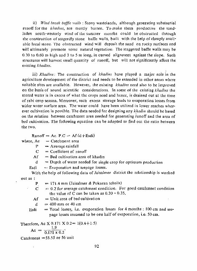
ii) Wind break bajjfe walls: Stony wastelands, although generating substantial runoff for the kllOdins, are mostly barren. To make them productive the sandladen south-westerly wind of the summer months could be obstructed through the construction of stagerdly stone baffle walls, built with the help of cheaply available local stone. The obstructed wind will deposit the sand on rocky surfaces and will ultimately promote some natural vegetation. The staggered baffle walls may be
0.30 to 0.60 m high and 3 to 5 m long. in curved alignment against the slope. Such structures will harvest small quantity of runoff, but will not significantly affect the existing khadins.
iii) KlJadins: The construction of khadins have played a major role in the agriculture development of the district and needs to be extended in other areas where suitable sites are available. However, the existing khadins need also to be improved on the basis of sound scientific considerations. In some of the existing khadins the stored water is in excess o~ what the crops need and hence, is drained out at the time of rabi crop season. Moreover, such excess storage leads to evaporation losses from wider water surface area. The water could have been utilized in lower reaches wherever cultivation is possible. The data needed for designing any khadin should be based on the relation between catchment area needed for generating runoff and the area of bed cultivation. The following equation can be adopted to find out the ratio between the two.
Runoff = Ac. P.C = Af Cd + Esdi) where, Ae
p
C Af
d
= Catchment area = Average rainfall = Coefficient of runoff = Bed cultivation area of khadin -= Depth of water needed for single crop for optimum produefion
Esdi = Evaporation and seepage losses. With the help of following data of Iaisalmer district the relationship is worked
out as P = 171.4 mm (Jaisalmer & Pokaran tehsils) C = 0.2 'for average catchment condition. For good catchment condition
the value of C can be taken as 0.30 - 0.35. Af = Unit area of bed cultivation
d = 400 mm or 40 em Esdi = Total losses, i.e. evaporation losses for 4 months: 100 em and see
page iosses assumed to be one half of evaporation, i.e. 50 cm.
Therefore, Ac X 0.171 X 0.2= 1(0.4+1.5) 1.9
Ac = 0.171xO.2 Catchment =55.55 or 56 unit
92
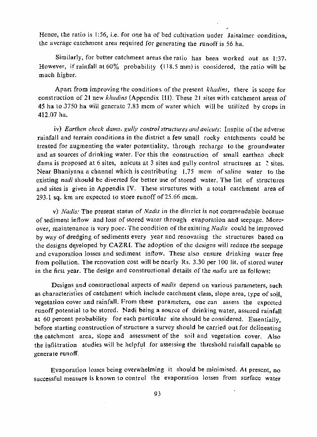
Hence, the ratio is 1:56, i.e. for one ha of bed cultivation under Jaisalmer condition, the average catchme_nt area required for generating the runoff is 56 ha.
Similarly, for better 9atchment areas the ratio has been worked out as 1 :37. However, if rainfall at 60% probability (118.5 mm) is considered, the ratio will be much higher.
Apart from improving the conditions oJ the present khadins. there is scope for construction of 21 new khadins (Appendix lIn. These 21 sites with catchment areas of 45 ha to ,3750 ha will generate 7.83 mcm of water which will be utilized by crops in 412.07 ha.
iv) Earthen check dams, gully control structures and anicuts: Inspite of the adverse rainfall and terrain conditions in the district a few small rocky catchments could be treated for augmenting the water potentiality, through recharge to the groundwater and as sources of drinking water. For this the construction of small earthen check dams is proposed at 6 sites, anicuts at 3 sites and gully control structures at ~ sites. Near Bhaniyana a channel which is contributing 1.75 mcm of saline water to the existing nadi should be diverted for better use of stored water. The list of structures and sites is given in Appendix IV. These structures with a total catchment area of 293.1 sq. km are expected to store runoff of25.66 mcm.
v) Nadis: The present status of Nadis in the district is not commendable because of sediment inflow and loss of stored water through evaporation and seepage. Moreover, maintenance is very poor. The condition of the existing Nadis could be improved by way of dredging of sediments every year and renovating the structures based on the designs d~veloped by CAZRI. The adoption of the designs will reduce the seepage and evaporation losses and sediment inflow. These also ensure drinking water free from pollution. The renovation cost will be nearly Rs. 3.30 per 100 lit. of stored water in the first year. The design and constructional details of the nadis are as follows:
Designs and constructional aspects of nadis depend on various parameters, such as characteristics of catchment which include catchment class, slope area, type of soil, vegetation cover and rainfall. From these parameters, one can assess the expected runoff potential to be stored. Nadi being a source of drinking water, assured rainfall at 60 percent probability for each particular site should be considered. Essentially, before starting construction of structure a survey should be carried out for delineating the catchment area, slope and assessment of the soil and vegetation cover. Also the infiltration studies will be helpf~l for assessing the threshold rainfall capable to
generate runoff.
Evaporation losses being overwhelming it should be minimised. At present, no successful measure is known to control the evaporation losses from surface water
93
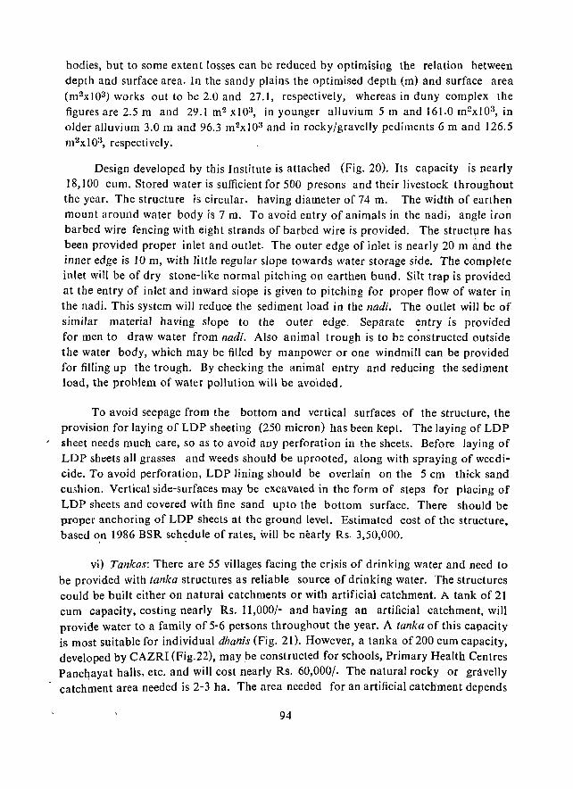
bodies, but to some extent losses can be reduced by optimising the relation between depth and surface area. In the sandy plains the optimised depth (m) and surface area (m 2x 10³) works out to be 2.0 and 27.1, respectively, whereas in duny complex the figures are 2.5 m and 29.1 m2 x103, in younger alluvium 5 m and 161.0 m2x103, in older alluvium 3.0 m and 96.3 m2xl03 and in rocky/gravelly pediments 6 m and 126.5 m2xI03, respectively.
Design developed by this Institute is attached (Fig. 20). Its capacity is nearly 18,100 cum. Stored water is sufficient for 500 presons and their livestock throughout the year. The structure is circular. having diameter of 74 m. The width of earthen mount around water body is 7 m. To avoid entry of animals in the nadi, angle iron barbed wire fencing with eight strands of barbed wire is provided. The structllre has been provided proper inlet and outlet. The outer edge of inlet is nearly 20 ill illld the inner edge is 10 m, with little regular slope towards water storage side. The complete inlet will be of dry stone-like normal pitching on earthen bund. Silt trap is provided at the entry of inlet and inward siope is given to pitching for proper flow of water in the nadi. This system will reduce the sediment load in the nadi. The outlet will be of similar material having slope to the outer edge. Separate entry is provided for men to draw water from nadi. Also animal trough is to be constructed outside the water body, which may be filled by manpower or one windmill can be provided for filling up the trough. By checking the animal entry and reducing the sediment load, the problem of water pollution will be avoided.
To avoid seepage from the bottom and vertical surfaces of the structure, the provision for laying of LOP sheeting (250 micron) has been kept. The laying of LOP sheet needs much care, so as to avoid any perforation in the sheets. Before laying of LDP sheets all grasses and weeds should be uprooted, along with spraying of weedicide. To avoid perforation, LOP lining should be overlain on the 5 cm thick sand cushion. Vertical side-surfaces may be excavated in the form of steps for placing of LOP sheets and covered with fine sand upto the bottom surface. There should be proper anchoring of LDP sheets at the ground level. Estimated cost of the structure, based ~n 1986 BSR sch:dule of rates, \vill be nearly Rs. 3,50,000.
vi) Tankas: There are 55 villages facing the crisis of drinking water and need to be provided with tanka structures as reliable source of drinking water. The structures could be built either on natural catchments or with artificial catchment. A tank of 21 cum capacity, costing nearly Rs. 11,000/- and having an artificial catchment, will provide water to a family of 5-6 persons throughout the year. A tanka of this capacity is most suitable for individual dhanis (Fig. 21). However, a tanka of 200 cum capacity, developed by CAZRI (Fig.22), may be constructed for schools, Primary Health Centres Panchayat halls, etc. and will cost nearly Rs. 60,000/. The natural rocky or gravelly catch~ent area needed is 2-3 ha. The area needed for an artificial catchment depends
94
r I
I, ~;~ s-u. :1:1
- I
II il" .. : .. :: j; ~il :1 A • .1 i; II -I iii I~
,~ I~
~ ;.
c:)
~ N
.a en .;: u:;
~I
. '
95

CONSTRUCTIONAL DETAILS OF A WATER TANKA FOR A SINGLE FAMILY
(CAPACITY 21 Cu.M.)
2 ..
r A
3% SLOPE ARTIFICIAL CATCHMENT
'Oem WITH CEMENT MORTAR I • DEEP
CATCH. PIT
SECTION AB
ARTIFICIAL CATCHMENT
• INLET WITH IRON BARS B EXPANDED METAL
U1EII OF Cl.~' OVER MURRUM 10 em. THICK
"-t B
D ...... 8y .• ( .~'U.
""j:\.2.1
Fig. 21.
96
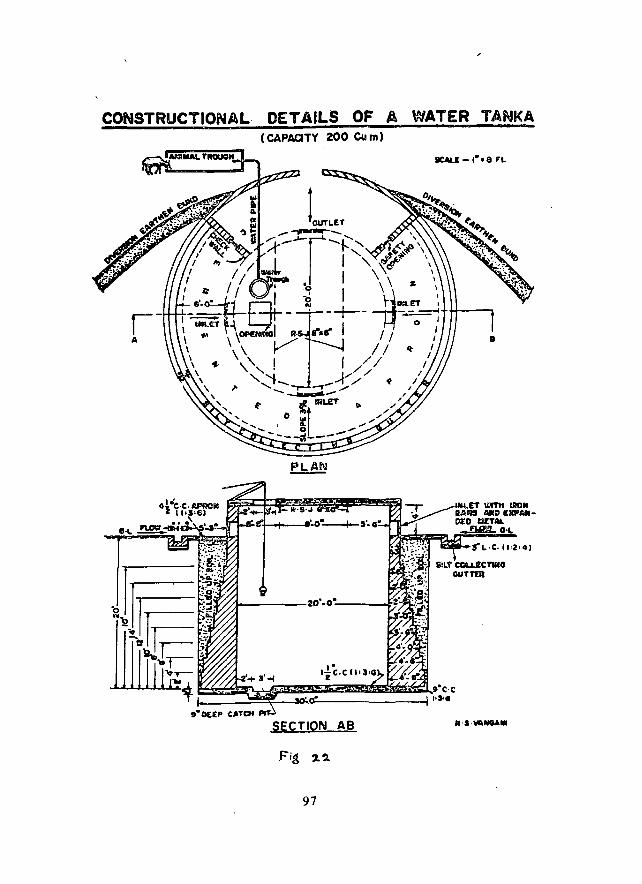
CONSTRUCTIONAL DETAILS OF A WATER TANKA (CAPACITY 200 Cu m)
IICAI..I - ,-. e FL
SECTION AB .·.·loIAlllGAlO
97
on the 60 percent of dependable rainfall in the particular part of the district. However, based on the rainfall data of Jaisalmer, the catchment area works out to be 1030 sq. m. If the catchment area is circular, the tanka diameter should be 32 m.
The catchment area required for the two types of tanka can be worked out with the help of the following equation.
Ac. Pd. C == m.d. Ao where, Ac = catchment area
Pd = runoff coefficient, 0.20 for an average catchment class, 0.30-0.35 for good catchment class and '0.60-0.70 for treated catchment
m = Storage coefficient - unity for tanka d = depth of tanka
Ao = cross sectional area of the tanka
Further, based on the assumption that evaporation and other losses from storage are negligible, per capita consumption from catchment is calculated by
C= L N
where, C = per capita consumption, litres/m2/day N = number of persons served by the catchment Y = mean daily catchment yield, litres/m 2, i.e.
dependable rainfall x runoff coefficient 365
From the above equations, it has been calculated that from a treated catchment of 500 sq.m wi th dependable rainfall (175 mm), 21 cum stored water in a tanka can serve a family of 6 members throughout the year. Designs developed by this Institute are discussed below.
Tanka of 21 cum capacity
Specifications:. The designed tanka is circular in shape, having 3 m diameter and a depth of 3 m. Circular shape is most econc.mical and is found to be more stable as the pressure exerted by water is uniform with radial pressure in all directions on the diametrical plane, right angle to the curved surface. The main structure can be built up with cement concrete (l :2:4) walls, 15 cm thick with minor reinforcement, or with stone masonry 30 cm thick with cement mortar I :4. At the base 25 em thick cement concrete (1:3:6) is sufficient to· bear the dead load and weight of water. Beneath the opening at the top, deep catchment pit is provided at the base to draw the minimum available water from the tanka.· Roof is covered with stone slabs, with opening of lOOx laO cm which ultimately is to be covered with iron lid for drawing of water. Three inlets and one outlet are provided. In case of excess inflow than the capacity, the
98
outlet will drain out the surplus water and will save the structure. Outlets and inlets are made of angle iron frame with expanded wire mesh These restrict the unwanted materials flowing with water. An apron, consistin_g of 10 cm cement concrete (I :3:6), 1 m wide, must be constructed around the tanka at ground level for smooth inflow of water. In case of natura·1 catchme,nt a silt collecting gutter around the tanka is also to be provided. Artificial catchment is made in circular saucer shape, having nearly 3% ·slope. This can be made by ramming a layer of murrum on the top or some impermeable treatment materials. All inner surfaces are to be cement plastered.
Tanka of 200 cum capacity
Specification: The tanka is circular in shape, having 6 m depth and 6 m diameter. Such a structure is normally constructed on community basis, such as for Panchayat halls or schools or Primary Health Centres. For optimum use of water, cooperation of all concerned is needed for such structures. Usually these are cor,structed on natural catchment. The catchment area of average class, free from vegetation, having slope of 2-3 percent and area of about 2 ha, is sufficient to generate runoff to its capacity. Walls are built with stone masonry in cement mortar I :4, resting on floor of cement concrete (1:3:6) 25 cm thick. A catch pit is also provided in floor. Extra excavated space around masonry structure should be filled with only fine sand and compacted with the help of a rammer after sprinkling water. At ground level cemented apron-12 cm thick (1:3:6) - of 2 m width is constructed around the tanka, which will protect the seepage towards outer faces of walls. The function of silt collecting gutter is to reduce the velocity of runoff and allow the suspended sediments to drop before reaching the inlet point. Two baffle walls, nearly 30 cm high with safdy opening, arc provided nearer the outlet for collecting water in case of need or
I to open the saiety opening in case of excess runoff. To restrict the entry of animals to tanka, animal trough is constructed at the back of diversion earthen bund, which is connected by G.I. pipe to water trough constructed on top of tanka roof. Inner surface of tanka is plastered with cement mortar. One percent of washing soap solution may. be added to act as water proofing material.
Maintenance and after care
Atleast once in a year cleaning of a tanka, ramming of its catchment and painting of the inlets and the outlets are must for keeping the tanka in good condition. Desilting of the tanka is also necessary and may be taken up before the onset of the monsoon. Periodical use of oxidising agents like potassium permanganate will prevent the growth of microscopic organisms and development of bad taste, odour and colour of the water. Alum helps in settling the dirt in suspension. At/east a few em of lVater eolumu should a/NllYs be maintained in the tanka to avoid development of cracks, etc.
99
7. Ground water potential areas for development
The potential areas within the district are shown in Fig. 23. Their characteristics are provided in Table 17. The following is a brief account of the potential zones.
i) Among the rocky aquifers the Lathi Sandstone formation is the most productive, due to its high permeability and transmissivity. There are five potential areas within this formation. These are (I) Ajasar area (61.12 sq.km), (2), Rajmathai area (412.50 sq.km), (3) Chandan area (3213.24 sq. km), and (4) Jhinjhiniyali area (376.00 sq.km area), where the quality of ground water is tolerably good (EC 1000-4000 fJ /
mhos), while (5) the Devra area (753.54 sq.km) in the south, has slightly 'saline water. The depth to water generally varies between 50 and 110 m.
(ii) The Pare;yar Sandstone formation is much less potential, covering a total of 694.20 sq.km area around Sanu and Koria. The EC of water varies from 1000-6000 u mhos in the Sanu area and from 4000 to 6000 ,tA mhos in Koria area. The average depth to water is 105 m.
iii) The Bhadasar formation has two potential areas. . The one near Myajlar has fresh quality water (2000-60001< mhos) and covers 327 sq.km area. The other around Dhaneli covers only 135 sq. km area and has slightly saline water (4000-6000 fJ. mhos). The average depth to water is between 75 m and 105 m.
iv) The Jodhpur formation has two smaller potential aquifers around Ratdiya
(139.75 sq.km area) and Ramdevra (255.31 sq.km area) where the water quality is tolerably fresh, and one slightly saline water aquifer around Sangram Singh Ki Dhani (116.93 sq.km area). The average depth to water is between 20 m and 25 m.
v) In contrast the Tertiary formations have not yielded so far any fresh quality aquifer. The one around Askandra, with an extent of about 200 sq.km, has slightly saline quality water.
vi) The Quaternaries, however, h-ave good potentialities in the extreme west, especially along the buried courses of the Saraswati, as has been suggested earlier. The potential zones appear to be around Kishangarh (409.37 sq.km) and Asu Tar (781.25 sq.km) with fresh quality water; and around Longewala (274.50 sq.km), Muhar (243.75 sq.km), Nachna (159.50 sq.km) and Naukh (455.12 sq.km) where the quality is slightly saline. The depth to water varies from 30 m to 50 m.
8. Improving the land use system
i) The introduction of canal water in the northern part of the district will . enlarge the agricultural activities in that part. However, irrigated agricultural 1and
use may not be the best system in the long run everywhere, because of several physi-
100

N
2.O'
I. - 'IIt:SH ClUALiTY 2. - SLIGHTLY SA~INE
OUALITY a. - .. oc.IIATELY SALINE QUALITY
o·
s
Fig. 23.
101
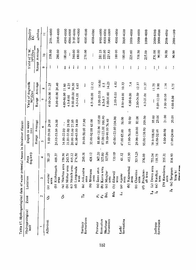
e; Q) o <=
·tiJ 0 o N
"0 '" OJ)
o ... "0
'" ::r:
o .0 o 0 o 0
"f '7 .J 0
::;, 0 o 0 "I "I
o o 00 M "I
o o .; ';' o o .;
o o 0-N
o C! 0--";' o ~ 0--
... 0'
o o o 0-"I
o v o "I
o C! o <I"
6 C! 00
o C! M
";' o o ..0 "I
o 0 00 o 0 0 0 o 0 0 0 \O\O\.O~ 0000 0000
~~N~
o o o 00
00 o 0 00 <I" 00 V)
go 0 0 \0 ....
6 • 0'" 0\';
000 o C! C! cOr--v N N V;
0000 C!C!C!C! NV'ltnV1
~:g~6 OC!OC! ~N~;
OV")NO '" r-- V; O\~v)~ I.tI -.::t "'" r--NVN
os e; ;;:: '" OIl",
c:; '" Q ... -lOS
o o o \0
a o o "<t
o o ,...: M
o o 00 V)
2, o 0\ -..... M
o o "I
.. (-0
o o o \0
6 o o v
N
N
o o V)
\0
o o
'" 0--
6 o N M
00 N V
000 000 000 \0 \0 "" 000 000 coo vN
00 0C! tr)\.00 oo~ 00 C!o
""'''' N N
00 C!o 00"": 0000
102
t
o a oi 0--
6 o 0\ ""'
o o o \0
6 o o "<t
o o o 00
o C! 00
6 C! "I
6 o M V
o o o v 6 o o N
o C! o 00
o o
:! . o o 00
o o ..0 V)
o o o v 6 o o N
o o or) "I "I
o o 0\ 6 C! \0
o o o V;
o o ..0 t-
6 o ,...:
o on "I :;;
o o o .... 6 o o
o V)
00 M M
o o o M
6 o 0\ "I
c:;
'" "0 Cos ro v .0 ... Uro
o o o .... 6 o o -o o vi "I "I
o o 0\ o
o o 00 M
6 C! M 0--
o o ~ M
00 08 (il"<t
00 00 00 N M
00 00 00' t- 0-N
V) 0 r-- 0 ...;'"
o o
'" . o C! 00
oc <:;0 OON OM
.6 oc ~~
.. .. -l-
o o o "'T o o o "I
o o o '"
o C! o
6 o on
o C! "I
o o o '" 6 o ...;
ro ... > ..
"0
E ro '" OJ ~ ... ro
o o o "';' o o o N
o o o '"
V) .... 'n
o o 00 6 o .;
o o o N
o o .; "I
6 C! t-
" ...,
cal limitations stated earlier. The natural Lasiurlls grasslands of Rahala-SultanaRanahu-Asu Tar area is best suited for rangeland development, where it can flourish as a fodder bank of the district and the state. Excessive irrigated agriculture, on the other hand, can permanently damage the land here, through salinity build-up, and replace the Lasillrus cover .. It is, therefore, suggested that the hi5h density Lasillrlls
belt be improved through supplem~ntal sprinkler irrigation and other range cares,
rather than replacement by agriculture with flood irrigation.
ii) The marginal lands in the district are being increasingly encroached upon
for cultivation, due to biotic pressure. This, however, leads to more vulnerability of the terrain to wind erosion. This trend needs to be restricted and animal husbandry
be given a better incentive through an all-out development strategy.
iii) Tourism has already established itself as a major occupation in and around Jaisalmer. However, opening up of some other spots of tourist attraction between Jaisalmer and Sam and also between Jaisalmer and Pokaran, alongwith all the amenities, will not only increase the tourist trade, but will also provide the local
inhabitants with job.
iv) The mining is not yet well developed within the district, although it has a
great potentiality in respect of limestone and oil and natural gas. This sector, therefore, needs attention in a planned manner [rom the beginning to forestall any environ
mental problem that generally comes up in the mining areas.
v) The Khadin system of cultivation is traditionally well suited to the environ
ment of the district. Hence it should be encouraged in areas where it is feasible. The / physical factors favourable for their development have already been described.
9. Improvement of animal husbandry and its subsidiary systems
i) Much of the district's area is either sandy, rocky/gravelly or saline wastes. Agriculture is severely restricted due to the harsh climate and soil limitations. Animal husbandry is, on the other hand, m~st viable in this dry climatic setting and is practic ted widely. Considering the potentiality of the land to support gratslands and the crucial role the animal husbandry can play in the development of its rural economy, this sector should be given due importance for development. While the condition of the grasslands could be improved through better range care, as stated earlier, attention need also to be paid towards improving the animal health and breed. The cattle fairs need also to be more numerous and well distributed. The animal products like milk, wool, meat, hide and skin need to be given more attention for efficient procurement, processing and distribution, so that these can further improve the economy of
the district.
103
ii) A number of cottage industries are traditionally d,ependent on the animal by-products, but are not getting proper incentives, leading to abandonment of the crafts, The milk sector is not so well developed as it should have been because of the potential grass cover and the livestock population. An integrated approach involving range development, livestock development and subsidiary small industry development (including dairy and wooI) will help in improving the situation. Since water and fodder are crucial for the animals these should be provided adequately along the animal migration routes.
10. Credit and training facilities for artisans
Due to modernization the traditional artisan crafts, being carried out formerly mostly in conjunction with the agricultural activity, bas dwindled. The artisans are, therefore, forced to seek other sources of employment or perish. To counter these processes it is suggested to provide balanced employment opportunity. The available artisan skills Gould be better utilized through the provision of credit and training faci lities and through improving the designs of the crafts. The artisan craft has a high potentiality for providing employment to the rural folk. Credit facilities from the cooperative and other banks should be provided in a more rational and uniform basis.
11. Strategies for controlling the damages by rodents
The use of toxic chemicals is the most effective, cheap and humane method of reducing rodent population. A number of toxic chemicals, as well as anticoagulants, are available for baiting the rodent. The most used one is zinc phosphide. For good effects 1.5 to 2 per cent of this should be thoroughly mixed with cracked food, grain like wheat, millet, rice, maize, or sorghum, along with 2 to 3 percent vegetable oil. Poison baiting for the field rodents should be carried out for a day only. If it is continued for more than a day, not only the consun;Jption of the poison bait beccmes so low that it is waste of labour and material, but the rodents also develop poison aversiop and bait shyness. Prior, to poiso.n baiting, prebaiting is essential. The modus operandi for poison-baiting sequence should be as follows:
Day 1 Prebaiting (Cracked foodgrain + 2-3% vegetable oi!)
Day 3 Prebaiting (Cracked foodgrain + 2-3% vegetable oil)
Day 5 Poison-baiting (Cracked foodgrain + 2-3% of vegetable oil + 1.5-2% zinc phosphide)
Day 8 Fumigation of live burrows only with aluminium phosphide tablets
Day 9 Harborage removal ,and sanitation
. & 10 Repeat the whole sequence after six months, or earlier, if required.
104
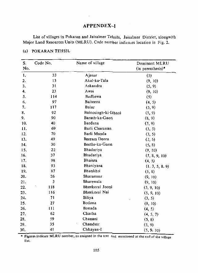
APPENDEX~I
List of villages in Pokaran and laisalmer Tehsils, laisalmer District, alongwith Major Land Resources Units (MLRU). Code number indicales location in Fig. 2.
(a) POKARAN TEHSIL
s. Code No. Name of village Dominant MLRU No. (in perenthesis)*
1. 33 Ajasar (5) 2. 13 Akal-ka-Tala (9, 10) 3. 31 Askandra (5,9) 4. 23 Awai (9, lo) 5. 114 Badhewa (5) 6. 97 Baiteena (4, 5) 7. 117 Balar (5,9) 8. 92 Baloosingh-ki- Dhani (5, 9) 9. 90 Barath-ka-Gaon (8, 9) 10. 40 Bardana (5,9) II. 69 Barli Charanan (3, 5) 12. 70 Barli Manda (3,5) 13. 49 Beeram Deora (2, S) 14. 30 Beethe-ka-Gaon (5. 8) 15. 22 Bhadariya (9, 10) 16. 37 Bhadariya (5, 8, 9, 10) 17. 98 Bhaisra (4, 5) 18. 93 Bhaniyana (I. 3, 5, 8,9) 19. 87 Bhankhri (5, 8) 20. 26 Bharamsar (9, 10) 21. 3 Bharewala (9, 10) 22. 118 Bheekorai Jooni (5, 9, 10) 23. 116 Bheekorai Nai (5,9, 10) 24. 71 Biliya (3, 5) 25. 27 Bodana (9, 10) 26. III Bonada (4, 5) 27. 62 Chacha (4, 5, 7) 28. 59 Chanani (5, 8) 29. 35 Chandsar (5, 9) 30. 41 Chhayan-I (5,9, 10)
* Figures indicate MLRU number, as assigned in the text and mentioned at the end of the village list.
105
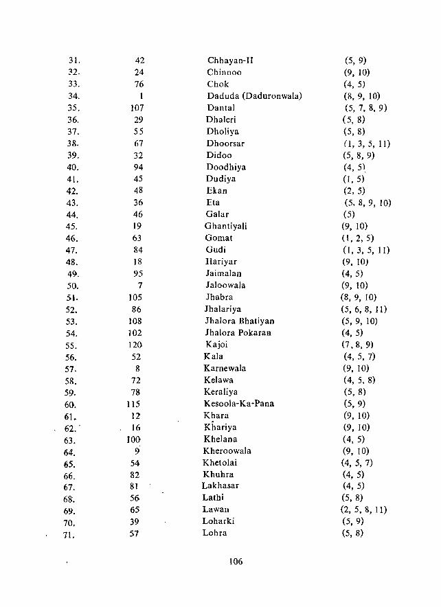
31. 42 Chhayan-I1 (5, 9) 32. 24 Chinnoo (9, 10) 33. 76 Chok (4, 5) 34. 1 Daduda (Daduronwala) (8, 9, 10) 35. 107 Dantal (5, 7, 8, 9)
36. 29 Dhaleri (5, 8)
37. 55 Dholiya (5, 8) 38. 67 Dhoorsar (1, 3, 5, II) 39. 32 Didoo (5, 8, 9) 40. 94 Doodhiya (4, 5),
41. 45 Dudiya (I, 5)
42. 48 Ekan (2, 5)
43. 36 Eta (5,8,9, 10)
44. 46 Galar (5)
45. 19 Ghantiyali (9, 10)
46. 63 Gomat (I, 2, 5)
47. 84 Gudi (1,3,5, II)
48. 18 Hariyar (9, 10)
49. 95 Jaimalan (4,5)
50. 7 Jaloowala (9, 10)
51. 105 Ihabra (8, 9, 10)
52. 86 Ihalariya (5, 6, 8, II)
53. 108 Jhalora Bhatiyan (5, 9, 10)
54. 102 Ihalora Pokaran (4, 5)
55. 120 Kajoi (7, 8, 9)
56. 52 Kala (4, 5, 7)
57. 8 Karnewala (9, 10)
58. 72 Kelawa (4, 5, 8)
59. 78 Keraliya (5, 8)
60. 115 Kesoola-Ka-Pana (5, 9)
61. 12 Khara (9, 10) 62 .. 16 Khariya (9, 10)
63. 100 Khelana (4, 5)
64. 9 Kheroowala (9, 10)
65. 54 Khetolai (4, 5, 7)
66. 82 Khuhra (4, 5)
67. 81 Lakhasar (4, 5)
68. 56 Latbi (5, 8)
69. 65 Lawan (2, 5, 8, 11)
70. 39 Loharki (5, 9)
71. 57 Lohra (5, 8)
106
72. 101 Loona Kalan (4, 5)
73. 96 Loona Khurd (4, 5)
74. 25 Madasar (9, 10)
75. 80 Madasar (4, 5)
76. 85 Madwa (I, 3, 5)
77. 60 Mahesha-ki-Dhani) (4,5)
78. 5 Malasar (9, 10j
79. 53 Maika (5)
80. 51 Mawa (5, 7)
81. 89 Medwa (Marwa) (3, 5)
82. 75 Modardi (4, 5)
83. 4 Moharonwala (9, 10)
84. 14 Nachna (9, 10)
85. 74 Nananiyai (5, 7)
86. 38 Nawatala (5,9)
87. 79 Neran (4, 5, 8)
88. 28 Nokh (8,9, 10)
89. 113 Ola (4, 5~
90. 61 Orhaniya (5, 7)
91. 88 Padroda (5, 8)
92. 15 Panche-ka-Tala (9, 10)
93. 10 Panna (9, 10)
94. 121 Phalsoond l7, 8, 9, 10)
95. 106 Phoolasar (7, 8,9)
96. 64 Pokaran (Rural) (2,5,11)
97. / 6 Raichandwala (9, 10)
98. 112 Rajgarh (4, 5)
99. 109 Rajmathai (4, 5, 9)
100. 50 Ramdeora (5, 7)
101. 110 Rampuriya (4, 5, 9)
102. 58 Ratan-ki-Bassi (5,8)
103. 103 Ratdiya (5, 7, 8, 9)
104. 44 Rathora (5)
105. 66 Rayad (5)
106. 2 Rohironwala (8,9, 10)
107. 21 Sakariya (5,9)
108. 104 Sakariya (5, 7, 9)
109. 77 Sanawara (4, 5, 8)
110. 43 Sanda (5)
11 L 99 Sangramsing-ki-Dhani (4, 5)
112. 83 Sankra (4, 5)
107
113. 47 Sarnayat (5)
114. 20 Satyaya (9, 10) 115. 17 Shekhonwala (9, 10) 116. 119 Swamiji-ki-Dhani (5, 8, 9)
117. 11 Tawariwala (9, 10)
118. 73 That (1,3,5,6,11)
119. 34 Tota (5,9)
120. 91 Uchpadra (5, 8)
121. 68 Ujla (I, 3, 5, 8)
b) lAISALMER TEHSIL S.No. Code No. Name of Village Dominant MLRU'"
(in perenthesis)
J. 304 Achla (4, 5)
2. 343 Adbala (9, 10)
3. 58 Adkiya (9, 10)
4. 93 Ainta (2, 5, 8)
5. 295 Akallodha (I, 3, 5)
6. 179 Akanwali (9, 10)
7. 272 Akralapar (5, 9, 10)
8. 338 Ala (9, 10)
9. 220 Amarsagar (2, 5)
W. 335 Antia (9, 10)
U. 81 Arjana (2, 5, 8)
12. 232 Arjanhar (5, 8,9)
13. 297 Asayacha (I. 3, 5)
J4. 326 Asloi (Asolai) (1,3,5)
15. 170 Asoda (9, 10)
J6. 157 Asooda (9, 10)
17. 29 Asoo·ka-Tala (9, 10)
1&. 172 Babuwali (9, 10)
19. 159 Baohhiya (9, 10)
20. 41 Bachhiya Chhor (9, 10)
21. 9 Baba (2, 5, 8)
22. 221 Bada Bag (2, 5)
23. 322 Badhan (1,3, 5)
24. 147 . Badhwa (9, 10)
25. 299 Badoda Gaon (I, 3, 5)
26. 165 Bagnau (9, 10)
27. 84 Bahia (7,8,9, 10)
* Figures indicate MLRU number, as assigned in the Text and mentioned at the end of the village
list.
108
28. 375 Baiya (9, 10)
29. 87 Balana (2,5,9, 10)
30. 336 Bambhara (9, 10)
31. 28 Bandha (2, 3, 5, 8, 9)
32. 56 Bandi (9, 10)
33. 266 Baran (3, 5, 9)
34. 166 Basana (9, 10)
35. 247 Basanpeer (Jooni) (2, 5, 8)
36. 248 Basanpeer (South) (2, 5, 8)
37. 374 Basda (9, 10)
38. 163 Batoi leewanwali (9, 10)
39. 164 Batoi Rahimwali (9, 10)
40. 347 Beejhota (3, 5, 9, 10)
41. 388 Beermani (I, 3, 5)
42. 178 Beeryali (9, 10)
43. 28t Bersiyali (9, 10)
44. 115 Bhadasar (1,2, 3, 5)
45. 241 Bhagoo-ka-Gaon (5, 8)
46. 238 Bhairwa (1,3,5,8,9)
47. 317 Bhakarani (5, 6)
48. 113 Bharamsar with (2,3,5,6,11)
Vaisakhi
49. 116 Bhatiya Khadeen (1, 3, 5)
50. 356 Bhelani (3, 5, 9)
51. 186 Bhiloi (9, 10)
52. 57 Bhinda Deslonwala (9, 10)
(Bhinda Desla)
53. 142 Bhinda Khara (9, 10)
54. 37 Bhinda Mangaliyawala (9, 10)
55. 253 Bhiyan (2, 3, 5)
56. 366 Bhiyasar (3, 5,9)
57. 243 Bhojasar (2, 3, 5, 8)
58. 240 Bhojka (4, 5)
59. 291 Bhoo (1,2, 3,5)
60. 197 Bhoon (9, 10)
61. 310 Bhopa (4, 5)
62. 321 Bhopa (2, 5)
63. 8 Bhutonwali (8,9, 10)
64. 136 Bhuwana (9, 10)
65. 183 Bichau (9, 10)
66. 208 Bida (5, 8,9)
109
67. 54 Birma (9, 10) 68. 390 Bogniyai (5) 69. 101 Doha (2, 3, 5) 70. 312 Bola (5, 8) 7L 83 Buili (7, 8, 9) 72. 160 Buranwali (9, 10) 73. 226 Chahdoo 0,2,5) 74. 55 Chakrau (9, 10) 75. 228 Chandbana (5, 8) 76. 50 Chandrau (9, 10) 77. 344 Chanpa (9, 10) 78. 110 Chaudhariya (2, 5, 6, R) 79. 316 Cheecha (3, 5, 8) 80. 346 Chelak (5,9, 10) 81. 328 Chatogar (Sa1a) (9, 10) 82. 124 Chhatrel (1,2,3,5) 83. 309 Chhodiya (5, 9) 84. 300 Chhor (3, 5, 8,9) 8.5. 135 Chhuganiyon-ki-Basti (5, 9, 10) 86. ]20 Chundhi (2, 5) &7. 251 Dabla (2, 3, 5) 8&. 203 Dabri (5, 8, 9) &9. 213 Damodara (I, 3,5, 8) 90. 360 Dangri (4, 5) 91. 250 Darbariyon-ka-Gaon (2, 5) 92. 280 Dav (9, 10) 93. 214 Dedha (3, 5) 94. 82 Deega (2, 5, 8)
95. 7 Deetowala (9, 10)
96. 234 Delasar (5, 8, 9)
97. 373 Deora (3, 5,9, 10)
98. 95 Deunga (2, 5, 8) 99. 311 Devikot (3, 5, 6, 8, 9) 100. 103 Dewa (1,3,5,6) 101. 175 Dbaloowali (9, ] 0)
102. 200 Dhanana (9, 10)
103. 268 Dhaneli (5,9, 10)
104. 294 Dbanwa (1,3,5,8)
lOS. 257 Dhauwa (2, 3, 5)
106. 27 Dhawala-ka-Par (2, 5,8,9)
. 107. 235 Dhaysar (5, 8, 9)
110
W8. 282 Dhoba (5, 9, 10)
109. 210 Dhuliya (5, 8)
110. 47 Dorau (9, 10) 11 L 125 Dujasar (3, 5) 112. 302 Duwara (5, 8, 9)
113. 26 Ekal-ka-par (2, 5, 8, 9) 114. ::'65 Fatehgarh (3, 5) 115. 173 Gajau (9, 10)
116. 378 Gajsingh-ka-Gaon (9, 10)
117. 21 Gamnewala (9, 10) 118. 260 Ganeshdas-ki-Dhani (2, 5) 119. 52 Ganesiya (9, 10) 120. 32 Ganesiya Kot (9, 10) 121. 206 Ganga (5, 8, 9) 122. 60 Geraja (9, 10) 123. 340 Geraja (9, 10) 124. 1 Ghotaru (9, 101 125. 6 Godhoowala (9, 10) 126. 105 Gogadeo (I, 3, 5, 8) 127. 286 Gorera (3,5) 128. 377 Guhra (9, 10) 129. 68 Habur (2,3, 5, 8) 130. 16 Hada (2, 5) 131. III Hadda (1,2,3,5.11) 132. 35 Hakra (9, 10) 133. 225 Hameera (2, 4, 5) 134. 134 Hameeron-ki-8asti (9, 10) 135. 24 Hansoowala (9, 10) 136. 256 Hansuwa (2, 5) 137. 339 Happa (Kalan & Khurd) (9, 10) 138. 371 Harbha (5, 9) 139. 188 Harda (9, 10) 140. 189 Harnau (9, 10) 141. 269 Hatar (9, to) 142. 69 Hema (2, 3, 5) 143. 23 Hingolawala (9, 10) 144. 187 Hotiya (9, 10) 145. 169 Indewali (9, 10) 146. 254 Jaisalmer (Rural) (2, 5) 147. 227 Jaisoorana (2, 3, 5, 8) 148. 215 Jajiya (3, 5, 9)
111
149. 152 Jamdau (9, 10) 150. 209 Jamra (3, 5) l5I. 150 Janiya (9, 10) 152. 327 Janra (5, 9, 10) 153. 154 Jasiya (9, 10) 154. 353 Jaswa (3, 5, 6) 155. 236 Jawandh Jooni (1, 3, 5, 8) 156. 237 Jawandb (Nai) 0, 3, 5) 157. 296 lerat (I, 3, 5) 15&. 255 Jayan (2, 5) 159. 229 letha (5, 8) 160. 222 lethwai (2, 5) 161. ISO Jhalariya (9, 10) 162. 190 lhanda Khara (9, 10) 163. 36 lhanda Madbujawol (9, 10) 164. 191 Ihanda Meetha (9, 10) 165-. 376 Jheenjaniyali (9, 10) 166. 258 Jiyai (2, 5) 167. 1~2 Jiyau Khara (9, 10) 168. 337 Jodha (9, 10) 169. 71 Joga (I, 2, 5) 170. 293 Joga (2, 5) 171. 381 Jagidas·ka·Gaon (3, 5, 9, 10) }'n. 218 Kahala (3, 5) 173. 12 Kakab (5, 8) 174. 185 Kalau (9, 10) ].75. 22 Kalibhar (9, 10) 176. 224 Kalyanghat 0, 2, 5) 177. 106 Kandiyala (1,3, 5) 17&. 168 Kangoor (9, 10) J79. 96 Kaqd Beerma (I, 2, 5, 8, 11) )g(}. 97 Kanod Rawlotan (1,2, 5, 8, 11) 181. 131 Kanoi (1, 3, 5, 8, 9) 182. 368 Kapuriya (5, 9, 10) 183. 199 Karamwala (Karmawali) (9, 10) 184. 275 Karda (9, 10) 185. 306 Karda (4,5) ]86. 155 Karta (9, 10) 187. 330 Katha (9, 10) 188. 349 Kathoda (3, 5, 8)
189. 109 Kathodi (1,3,5)
190. 278 Kerla (9, 10)
112
] 91. 89 Keroo (5, 8, 9, 10)
192, 127 Keshvon-ki-Basti (3, 5, 9)
193. ' 193 Khabdela (9, 10)
194. 212 Khabha (5, 8, 9, 10)
195. 123 Khanderon-ki-Dhani (3, 5)
196. 92 Khara Narayatan (9, ]0)
197. 94 Khardi (5, 6, 9, It)
198. 46 Khariya (9, 10)
199. 329 Khariya (Jethwai) (9. 10)
200. 146 Khariya (Maikhan) (9, 10)
201. 76 Kheeya 12, 5)
202. 75 Kheeya Raharki (2, 5)
203. 153 Khui Fetu Ianwali (9, 10) (Khadoojanwali)
204. 66 Khuiyala (2, 3, 5, 8, 9)
205. 282 Khuri (5, 8, 9, 10)
206. 351 Khyala (9, 10)
207. 292 Kinta (I, 3, 5)
208. 181 Kiradwali (9, 10)
209. 5 Kishangarh (9, 10)
210. 223 Kishanghat (2, 5)
211. 354 Koda (5,9}
212. ~59 Kodiyasar (3, 5)
213. 382 -Kohra (Kohara) (1,3,5,9)
214. :5 Kolootala (5, 8,9, 10)
215. ,- 270 Koriya (5,8, 9, 10)
216. 323 Koruwa (t, 3, 8)
217. 372 Kotha (5,9)
218. 285 Kotri (I, 3, 5, 8)
219. 67 Kuchhri (3,5,8)
220. 141 Kulatala (9, 10' 221. 262 Kuldhar (1,2,5,8)
222. 265 Kumhar Kotha (3, 5)
223. 383 Kunda (9, 10)
224. 161 Kundhau (9, 10)
225. 171 Kuntara (9, 10)
226. 102 Lakha (2, 5, 8)
227. 386 Lakha (5, 9, 10)
228. 358 Lakhmana (5,9)
229. 129 Lakbmanon-ki· Basti (5, 8, 9. 10)
230. 307 Lala (4,5)
113
231. )62 Lalewall (9, 10) 232. 273 Lambapar (9, 10) 233. 114 Lanela (1,3,5) 234. 33 Langtala 19, 10) 235. 45 Laloi (9, JO) 236. 121 Liderwa with (2, 5)
Deori-ki-Dhani 237. ]56 Lohar (9, 10) 238. 2 Longhwala (9, 10) 239. 130 Loona-ki·Basti (I, 3, 5, 8, ,9) 240- 274 Loonar (9, 10) 241. 167 Maghla (9, 19) 242. 176 Maghalwali (9, 10) 243. 39 Mahwa (9, 10) 244. 230 Maligara (3, 5, 8) 245. 63 Malingda (9, 10) 246. 42 Mamdau (9, 10) 247. 325 Manda (I, 3, 5) 248. 394 Mandai (3, 5) 249. 79 Mandha (2, 3, 5, 8, 9) 250. 98 Mandhau (5, 8, 9) 251. 385 Mandli with (5,9, 10)
Mehron-ki-Dhani 252. 217 Manpiya (3,5) 253. 205 Matwon-ki· Basti (5, R, 9)
254. 62 Meerwala (9, 10)
255. 48 Meethatala (Mithatar) (9, 10)
256. 51 Meethdau Sachetan (9, 10) 257_ 348 Megha (1,5,9, 10) 25&_ 216 Meghwalon-ki-Dhani (3, 5) 259'_ 204 Mehboob-ka-Par (5, 8, 9)
260 .. 149 Mehna (9, 10)
261. 140 Mehnau (9, 10)
262'. 305 Mehrajodh (4, 5)
263:. 144 Mehrana (9, 10)
264- 361 Mehreri (4,5)
265. 91 Mengi (Menki) (9, 10)
266. 177 Mithi Khui (9, 10)
267. 277 Mithrau Kharewa (9, 10)
263. 49 Mochiyonwala (9, 10)
269. 389 Modha (5, 8)
210. 313 Modha Ganesbpura (3,5, 6)
114
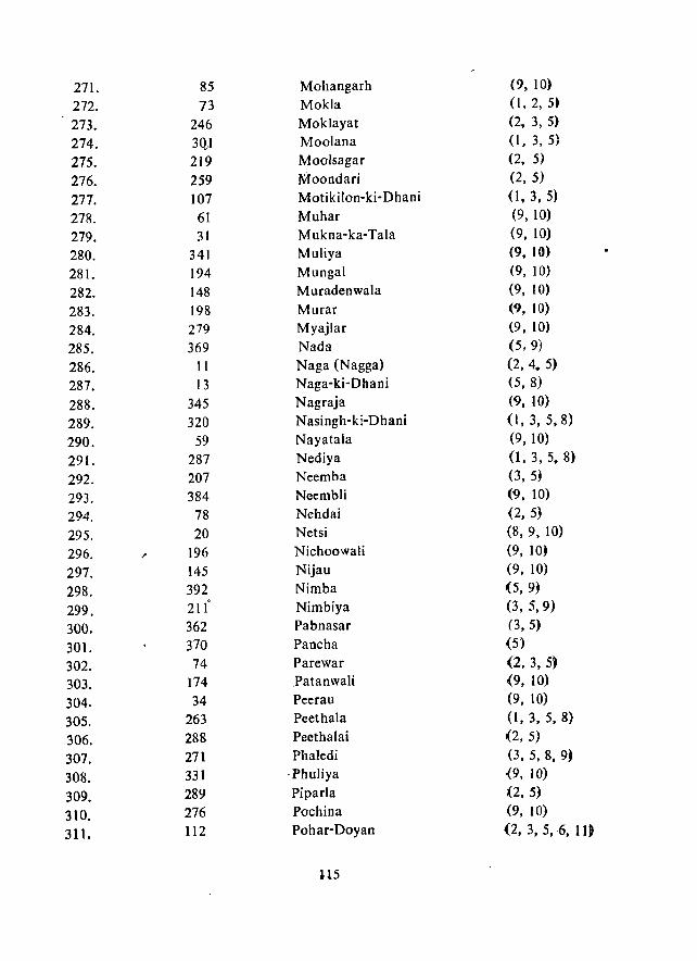
271. 85 Mohangarh (9, 10)
272. 73 Mokla (I, 2, 5'
273. 246 Moklayat (2, 3, 5)
274. 3QJ Moolana (I, 3,5)
275. 219 Mooisagar (2, 5)
276. 259 Moondari (2, 5)
277. 107 Motikilon-ki-Dhani (I, 3, 5)
278. 61 Muhar (9,10)
279. 31 M ukna-ka-Tala (9, 10)
280. 341 Muliya (9. 10)
281. 194 Mungal (9, 10)
282. 148 Muradenwala (9, 10)
283. 198 Murar (9, 10)
284. 279 Myajlar (9, 10)
285. 369 Nada (5,9)
286. 11 Naga (Nagga) (2, 4. 5)
287. 13 Naga-ki-Dhani (5, 8)
288. 345 Nagraja (9, 10)
289. 320 Nasingh-ki-Dhani (1,3,5,8)
290. 59 Nayatala (9, 10)
291. 287 Nediya (1, 3, 5. 8)
292. 207 Neemba (3, 5)
293. 384 Neembli (9, 10)
294. 78 Nehdai (2, 5)
295. 20 Netsi (8,9, 10)
296. 196 Niehoowali (9, 10~
297. 145 Nijau (9, 10)
298. 392 Nimba (5, 9~
299. 21( Nimbiya (3, 5,9)
300. 362 Pabnasar (3, 5)
301. 370 Paneha (5)
302. 74 Parewar (2, 3,5)
303. 174 .Patanwali (9, 10)
304. 34 Peerau (9, 10)
305. 263 Peethala (1,3, 5, 8)
306. 288 Peethalai (2,5)
307. 271 Phaledi (3, 5, 8, 9)
308. 331 ·Phuliya {9, 10)
309. 289 Piparla (2,5)
310. 276 Poehina (9, 10)
311. 112 Pohar-Doyan (2, 3, 5, 6, II)
U5

312. 290 Polji-ki-Dhani (2, 3, 5) 313. 357 PUllsar (5,9) 314. 138 Rabhalu Fakirollwala (9, 10)
315. 139 Rabhlau Rajronwala (9, 10)
316. 18 Raghwa (2, 5, 8,9, 10)
311. 201 Rahoo-ka-Par (5, 8, 9, 10)
318. I 15 Raimala (2, 5)
319. 350 Rama (1,3,5, 9)
320. 19 Ramgarh (2, 5, 8,9, 10)
·321. 119 Ram Kunda (2, :)
322- 387 Randha (J, 3, 5, 8, 9)
323. 303 RasIa (4, 5, 8)
324. 43 Ratdau (9, 10)
32.5. 77 Ratta (2, 5)
326. 44 Ratwa (9, 10)
327. 86 Rehrund (9, 10)
~2S. 192 ReIna (9, 10)
329. 367 Rewari (3, 5, 9)
330. 244 Righwa (5, 8)
331. 118 Roopsi (2, 5, 8, 11)
332- 14 Sadhna (5, 8)
333. 3 Sadhowala (9, 10)
334. 364 Sadhnwa (Sadhwa) (3, 5)
335. 249 Sadiaor Dadiya (2, 5)
336. 99 Sadrau (Pohar) (2. 5, 8, 9)
337. 239 Sagra (3, 5, 8)
338. 133 Sagron-ki· Basti (2, 5, 8, 9)
339. 393 Sajeet (3, 5, 9)
340. 126 Salkhan (1,2,3, 5)
341. 132 Sam (2, 3, 5, 8, 9)
342. 202 Samej~n-ka·Par (9, 10)
343. 308 Samwata (4, 5)
344. 324 Sanda (J, 3, 5, 9)
345. 298 Sangana (3, 5)
346- 355 San gar (3, 5, 8, 9)
347. 53 Sanger (9, 10)
348. 100 Sankhla (2, 3, 5, 8, 9)
?49. 332 Satto (9, 10)
350. 242 Sanwala (5, 8)
351. 264 SapIa (3, 5, 8,9)
3'52. 261 Sata (2, 3, 5)
353. 334 Sehdar (9, 10)
116
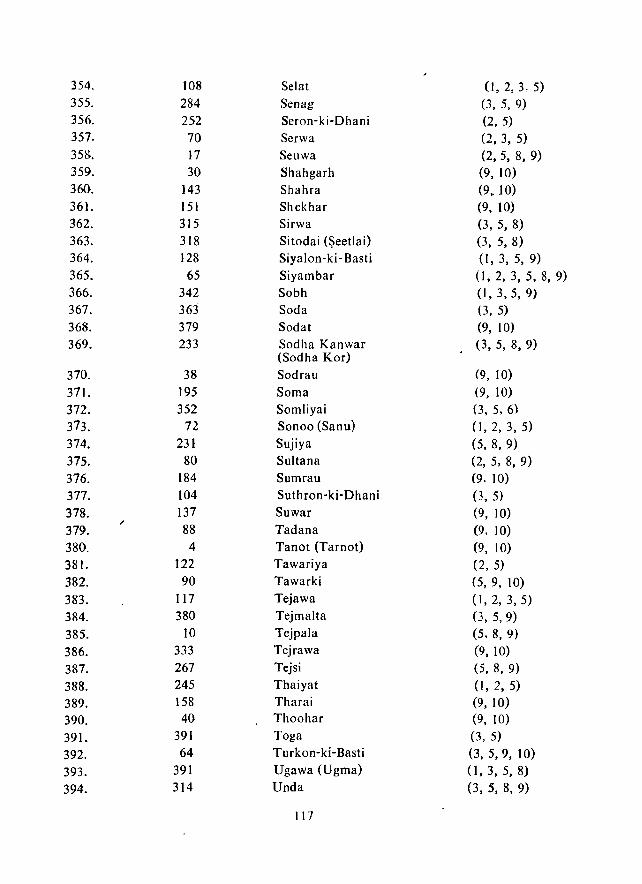
354. 108 Selat (I, 2,3,5) 355. 284 Senag (3, 5, 9) 356. 252 Seron-ki-Dhani (2, 5) 357. 70 Serwa (2, 3, 5) 358. 17 Seuwa (2,5, 8, 9) 359. 30 Shahgarh (9, 10) 360. 143 Shahra (9,.10) 361. lSI Shekhar (9, 10) 362. 315 Sirwa (3, 5, 8) 363. 318 Sitodai (Seetlai) (3, 5, 8) 364. 128 Siyalon-ki- Basti (1, 3, 5, 9) 365. 65 Siyambar (I, 2, 3, 5, 8, 9) 366. 342 Sobh (1,3,5,9) 367. 363 Soda (3, 5) 368. 379 Sodat (9, 10) 369. 233 Sodha Kanwar (3, 5, 8, 9)
(Sodha Kor) 370. 38 Sodrau (9, 10)
371. 195 Soma (9, 10)
372. 352 Somliyai (3, 5, 6)
373. 72 Sonoo (Sanu) (I, 2, 3, 5)
374. 231 Sujiya (5, 8, 9)
375. 80 Sultana (2, 5, 8, 9)
376. 184 Sumrau (9. 10)
377. 104 Suthron-ki-Dhani (3, 5)
378. 137 Suwar (9, 10)
379. 88 Tadana (9. 10) 380. 4 Tanot (Tarnot) (9, 10) 381. 122 Tawariya (2, 5)
382. 90 Tawarki (5,9, 10)
383. 117 Tejawa (1,2,3,5)
384. 380 Tejmalta (3, 5, 9)
385. 10 Tejpala (5, 8, 9)
386. 333 Tejrawa (9, 10)
387. 267 Tejsi (5, 8, 9)
388. 245 Thaiyat (1,2,5)
389. 158 Tharai (9, 10)
390. 40 Thoohar (9, 10)
391. 391 Toga (3, 5)
392. 64 Turkon-ki-Basti (3, 5,9, 10)
393. 391 Ugawa (Ugma) (1, 3, 5, 8)
394. 314 Unda (3, 5, 8, 9)
117
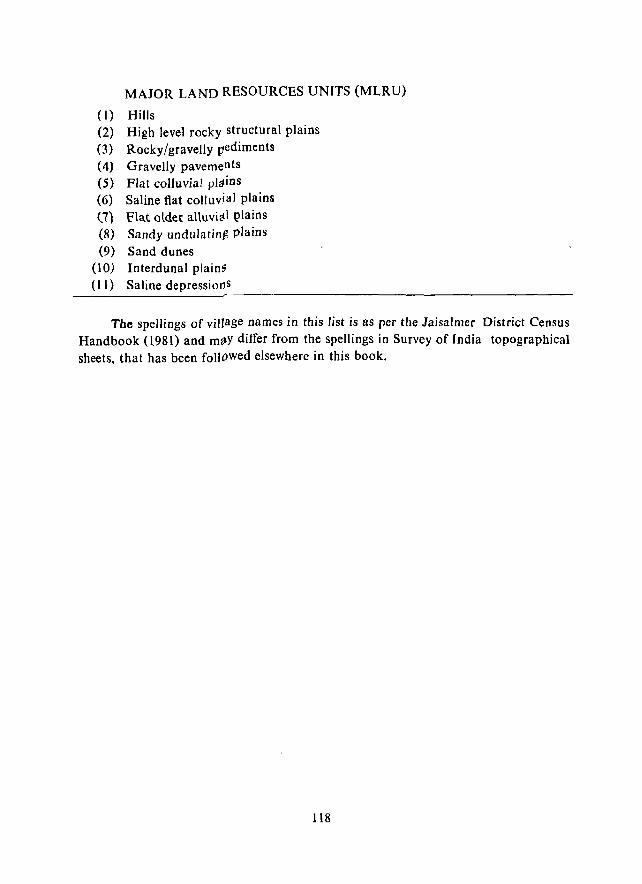
MAJOR LAND RESOURCES UNITS (MLRU)
(I) Hills (2) High level rocky structural plains (3) Rocky/gravelly pediments (4) Gravelly pavements (5) Flat colluvial pldins
(6) Saline flat colluvial plains (7) Flat older alluvial {_)Iains (8) Sandy undulatin,S plains (9) Sand dunes
(l0) Interdunal plainti (11) Saline depressiorJ s
-------------------------------------------Tbe spellings of village names in this list is as per the Jaisalmer District Census
Handbook (1981) and m~y differ from the spellings in Survey of India topographical sheets, that has been followed elsewhere in this book.
118
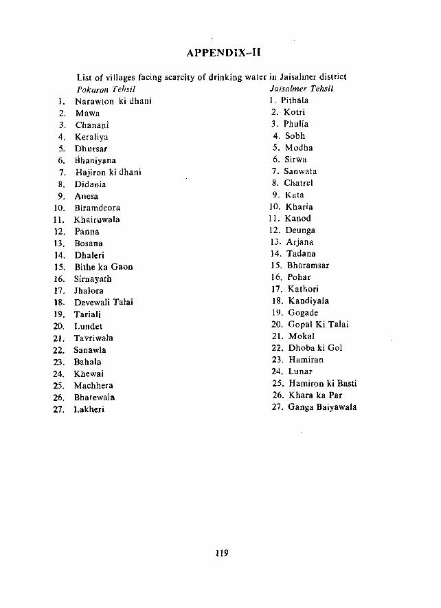
APPENDiX~I1
List of villages facing scarcity of drinking water in laisalmer district Pokaran Tehsi/ laisa/mer Tehsil
1. Narawton ki dhani I. Pithala 2. Mawa 2. Kotri 3. Chanani 3. Phulia
4. Keraliya 4. Sobh
5. Dhursar 6. Bhaniyana 7. Hajiron ki dhani
8. Didania 9. Anesa
10. Biramdeora 11. Khairuwala
12. Panna 13. Bosana 14. Dhaleri 15. Bithe ka Gaon 16. Sirnayath 17. Ihalora 18. Devewali Talai
]9. Tariali
20. Lundet 21. Tavriwala
22. Sanawla 23. Bahala 24. Khewai 25. Machhera 26. Bharewala 27. Lakheri
119
5. Modha 6. Sirwa 7. Sanwata 8. Chatrel
9. Kata 10. Kharia II. Kanod 12. Deunga 13. Arjana 14. Tadana IS. Bharamsar 16. Pohar 17. Kathori 18. Kandiyala 19. Gogade 20. Gopal Ki Talai
21. Mokal 22. Dhoba ki Gol 23. Hamiran 24. Lunar 25. Hamiron ki Basti 26. Khara ka Par 27. Ganga Baiyawala

APPENDIX-III
. New sites for development of Khadins in laisalmer district (Average rainfall at 60% probability= 118.5 mm)
Water- Survey Expe- Proposed shed of Catch- Catch- cted area under No. in India ment ment run bed cl,llti-
S. Fig. 13 sheet condi- area off vation
No. Name of site and 14 No. tion (ha) 3;JxlL.3 (ha)
1. East of Khuiyala I 40 J/8 Good 1687 599.72 31.56 2. Hingola 2 40 1/8 Good 2687 955.23 50.27 3. Joga 3 40 1/11 Good 2500 888.75 46.77 4. Randha 8 40 J/16 Oood 1625 577.69 30.40 5. Kohra 9 40 J/16 Cood 1250 444.38 23.39 6. Dabhala 14 40 Nil Good 3750 1333.12 70.16 7. North of Rei 15 40 1/16 Good 2500 888.75 46.77
Khadin 8. Akol 16 40 Nil Good 2250 799.87 42.09 9. W0st of Asayach 17 40 Nil Good 1562 555.29 29.22
10. Lulai 25 4') J/6 Average 307 72.76 3.83 11. Harbha 26 40 N/3 Average 175 41.48 2.18 12. Rivri 27 40 N/3 Average 287 68.00 3.58 13. Bhiyasar 28 40 N/3 Average 75 17.78 0.94 14. Chatrel 29 40 J/9 Good 405 143.98 7.58 15. Polji ki dehri 30 40 J/13 Good 112 39.82 2.09 16. Nar Singh ji 31 40 J/14 Good 277 98.47 5.18
ki dhani 17. Korwan 32 40 J/l4 Good 360 127.98 6.74 18. Neran 33 40 N/5 Cood 172 61.14 3.22 19. Javandh 34 40 N/5 Good 45 16.00 0.84 20. Basanpir 35 40 N/I Average 232 54.98 2.89 21. Bhagu ka gaon 36 40 N/I Average 190 45.03 2.37 22. Mogini Khadin Needs
near Arjana rep~ir -------------
Total 244.48 7.83 412.07 ha sq.km mcm or
4.1207 sq. km
120
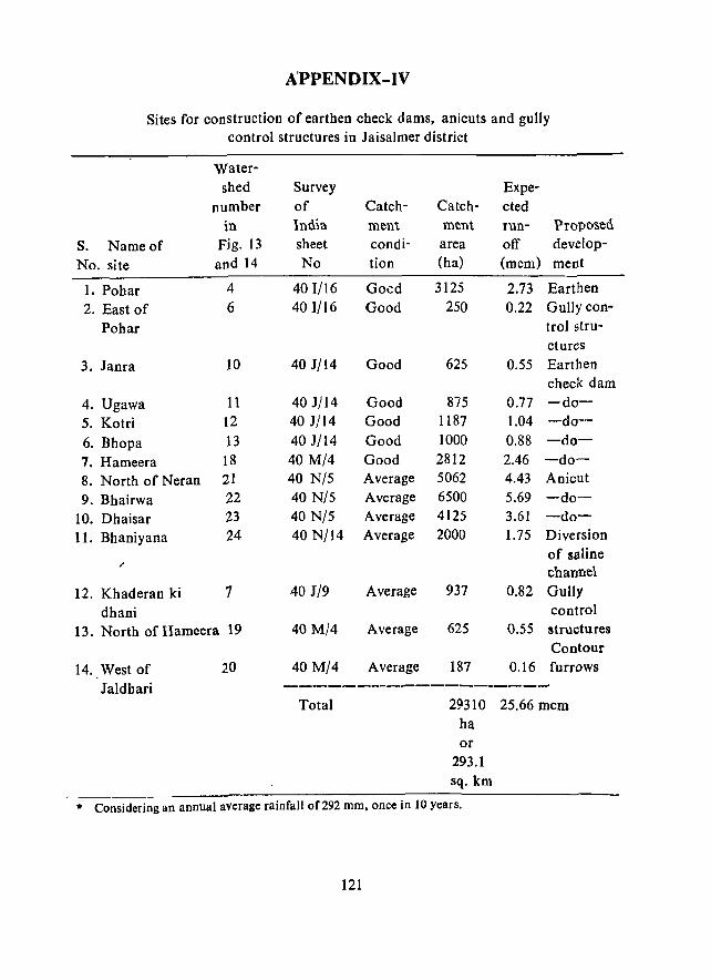
APPENDIX-IV
Sites for construction of earthen check dams, anicuts and gully control structures in Jaisalmer district
Water-shed Survey Expe-
number of Catch- Catch- cted in lndia ment ment run- Propo'1>ed
s. Name of Fig. 13 sheet condi- area off develop-
No. site and 14 No tion (ha) (mem) ment
1. Pobar 4 401/16 Goed 3125 2.73 Earthen
2. East of 6 401/16 Good 250 0.22 Gully con-
Pohar trol stru-ctures
3. Janra 10 401/14 Good 625 0.55 Earthen check dam
4. Ugawa 11 40 J/14 Good 875 0.77 -do-
5. Kotri 12 40 J/14 Good 1187 1.04 -do-
6. Bhopa 13 40 J/14 Good 1000 0.88 -do-
7. Hameera 18 40 M/4 Good 2812 2.46 -do-
8. North of Neran 21 40 N/5 Average 5062 4.43 Anicut
9. Bhairwa 22 40 N/5 Average 6500 5.69 -do-
lO. Dhaisar 23 40 N/5 Average 4125 3.61 -do-
ll. Bhaniyana 24 40 N/14 Average 2000 1.75 Diversion of saline .-channel
12. Khaderan ki 1 40 J/9 Average 937 0.82 Gully
dhani control
13. North of Hameera 19 40 M/4 Average 625 0.55 structures Contour
14. West of 20 40 M/4 Average 187 0.16 furrows
1aldbari --------------------Total 29310 25.66 mem
ha or
293.1 sq. km
* Considering an annual average rainfall of 292 mm, once in 10 years.
121
APPENEDIX-V
NATURAL RESOURCES OF SAM PANCHAyAT SAMITI
INTRODUCTION
Located in the extreme western part of laisalmer district Sam Panchayat Samiti is the largest Samiti (Development Block) within the district. It covers 2, I I I, 128 ha land and has a population of65, 513 (1981 census). The climate is extremely arid. The average annual rainfall varies from 175 mm in the southeast to less than 100 mm in the northwest. The mean maximum temperature (May) varies from 41.5°C'to more than 42°C, while the mean minimum temp;:rature (January) varies from less than 4°C to 9·C. The mean annual potential evapotranspiration varies from 2000 mm to 2200 mm and more. The expected date of onset of the monsoon is the] 5th July in the southeast, while in rest of the area the expected date is the 20th July. The monsoon generally withdraws by 1st September. The dominant wind is during the hot March to September when it blows from SSW or SW. In the rest of the year a weak NE wind blows.
There are 276 villages within the Samiti. The settlement pattern is generally scattered and the villages are mostly located in the interdune areas. The eastern part of the Samiti is dominantly rocky/gravelly.
The resource patterns within the Samiti and the suggestions for their improvement are as follows.
GEOMORPHOLOGY
Nature of the terr~in
Located in the less than 150 mm annual rainfall zone Sam Pancbayat Samiti is dominated by aeolian processes and sandy terrain. The rocky/gravelly terrain, along with shallow, colluvium-covered plains, occupy the eastern margin of the Samiti. Whildhe sandy terrain occupi'es 15533.5 sq. km area (73.59% of the total Samiti area), the rocky/grav~lIy terrain occupies only 5577.8 sq. km area (26.41 % of the total).
There are two notable ephemeral channels in the Samiti: (a) the Ramgarh Nala, which originates in the rocky terrain near Ramgrah, flows northward and dies out before Ranahu in the sandy terrain, and (b) the Vikharan Nadi, which originates in the rocky terrain of Kbuiya:la, flows intermittently past Bandah northwestward and dies out before Ghotani.
Nine landform units have been identified in the Samiti (Table 18, Fig. 24). The maximum area of 12986.2 sq.km (61.51 % of the total) covered with sand dunes of different types. Among these the megabarchanoid fields to the south of Shahgarh and the
122
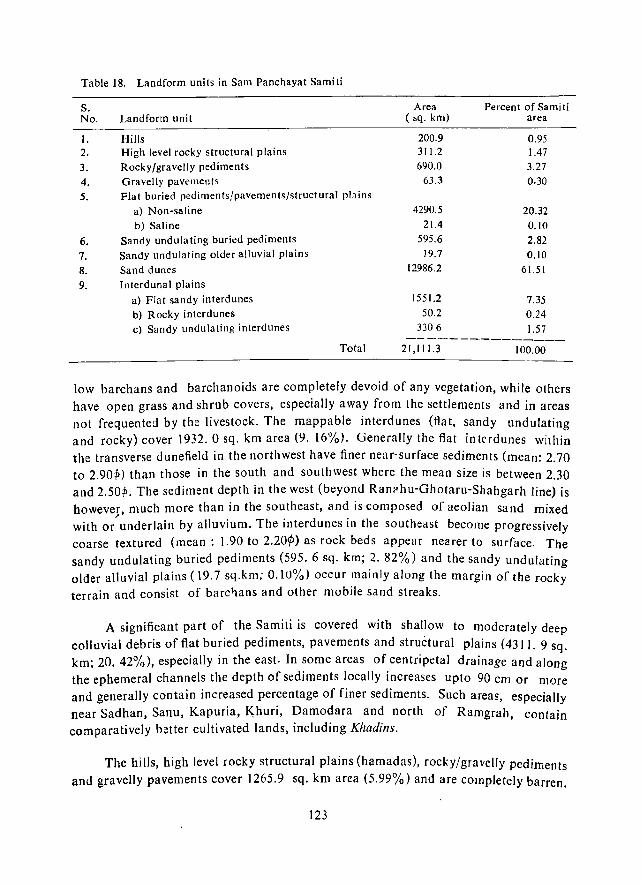
Table 18. Landform uni ts in Sam Panchayat Sami ti
S. Area Percent of Samiti No. Landform unit ( sq. km) area
I. Hills 200.9 0.95 2. High level rocky structural plains 311.2 1.47 3. Rocky/gravelly pediments 690.0 3.27 4. Gravelly pavements 63.3 0.30 5. Flat buried pediments/pavements/structural plains
a) Non-saline 4290.5 20.32 b) Saline 21.4 O.JO
6. Sandy undulating buri.:d pediments 595.6 2.82 7. Sandy undulating older alluvial plains 19.7 0.10 8. Sand dunes 12986.2 61.5J
9. Interdunal plains a) Flat sandy interdunes J 551.2 7.35 b) Rocky interdunes 50.2 0.24 c) SandY undulating interdunes 3306 1.57
Total 21,1 11.3 100.00 -------------------------------------------------------------
low barchans and barchanoids are completely devoid of any vegetation, while others have open grass and shrub covers, especially away from the settlements and in areas not frequented by the livestock. The mappable interdunes (flat, sandy undulating and rocky) cover 1932.0 sq. km area (9. 16%). Generally the flat interdunes within the transverse dunefield in the northwest have finer near-surface sediments (mean: 2.70 to 2.901» than those in the south and southwest where the mean size is between 2.30 and 2.50"'. The sediment depth in the west (beyond Ran?hu-Ghotaru-Shahgarh line) is boweves, much more than in the southeast, and is composed of aeolian sand mixed with or underlain by alluvium. The interdunes in the southeast become progressively coarse textured (mean: 1.90 to 2.20¢» as rock beds appear nearer to surface. The sandy undulating buried pediments (595.6 sq. km; 2. 82%) and the sandy undulating older alluvial plains (19.7 sq.km; 0.10%> occur mainly along the margin of the rocky terrain and consist of barc'1ans and other mobile sand streaks.
A significant part of the Samiti is covered with shallow to moderately deep call uvial debris of flat buried pediments, pavements and structural plai ns (4311. 9 sq. km; 20. 42%), especially in the east. In some areas of centripetal drainage and along the ephemeral channels the depth of sediments locally increases upto 90 cm or more and generally contain increased percentage of finer sediments. Such areas, especially near Sadhan, Sanu, Kapuria, K,huri, Damodara and north of Ramgrah, contain comparatively better cultivated lands, including Khadins.
The hills, high level rocky structural plains (hamadas), rocky/gravelly pediments
and gravelly pavements cover 1265.9 sq. km area (5.99%) and are completely barren.
123

LANDFORMS SAM PANCHAYAT SAMITI
(JAISALMER OtSTRICT) o 10 20 lIO 40 !jO
KILOMETIIES
(Approximate) SCHEMATIC
"GHOTIJIU •
• TANDT , .
· .:'\ · . "-.... , · .... ",
:K<?<~~H: i . \ \. .. \.-._.,.;-........
LEGEND
MAJOR HILLS
~OltAY(fSAJ,n_~'r PEOlfAENTS WITH
GRAVELLY PAVEMENTS
•• 0 FLAT SURIED PEDIMENTS/PAVEMENTS
Fig. 24
124
[fill SALINE FLAT BURIED PEDIMENTS
[;] SANOY UNDuLATING BURIED PEDIMENTS
rr::l SANOY UNDUlATING OLDER AlLUVIAL
o so,NO DUNES ANO INTEROUNAl PLAINS
./ MA..K)R ESCARPMENTS
The characteristics of all these landforms are given in chapter IV.
Assessment of processes
Because of extreme aridity, efficient aeolian processes and dominance of sandy terrain, the Samiti is affected mainly by aeolian hazards of different intensities (15533.5 sq. kill; 73.59% of the total area). The rest 5577.8 sq. km area (26.41 %) is either free from hazards or is affected by negligible fluvial erosion, especially in the
southeast.
SOILS AND LAND USE CAPABILITY
There is appreciable variability in the soils of Sam Panchayat Samiti. Nearly 70% of its area is covered by very deep, loose, single grained, droughty aeolian sands with uniform soil profile of dunes and interdunal plains. These soils occur mainly in the extreme northern, western and southern parts.
In the north· eastern and south-eastern parts of the Samiti there is large variation in the soils due to various lithological formations at shallow depth. On the basis of morphological characteristics like soil depth, colour, texture, structure, parent material and physiographic setting, fourteen soil series have been mapped, besides the shallow, miscellaneous soils and hills. These soil series have been further grouped under (A) coarse textured soils, (8) medium textured soils, (C) moderately fine textured soils, (D) shallow miscellaneous soils, and (E) rocks and hills (Fig. 25).
Characteristics of major soil groups
(a) Coarse textured soils
Seven soil series, namely, Duny complex, Madasar, Sam, Myajlar, Dabla, . Ghotaru and Sodakor, are included in this group. These soils usually have coarser sand at surface and fine sand to loamy fine sand in the subsoil, followed down the profile by either deep aeolian sand, or weak to well developed lime concretion or weathered rock.
Limitations: Major limitati9ns are (i) hummocky sandy relief; (ii) loose sandy soil, prone to wind erosion: (iii) very low water retention capacity; and (iv) very poor fertility status and root zone limitation in soils like Sam, Ghotaru and Sodakor series.
Potentials: Lasiurus sindicus and Eleusine compressa grasses grow well on these soils. Pasture lands are also well ~stablished on these soils.
(b) Medium textured soils
This group includes four soil series, namely Bida, Ajasar, Lakha and Nedai. These soils have sand to loamy sand texture at surface and sandy loam to loam in
125
(Approximate)
SCHEMATIC
,
Fig. 25
126
... iO ... "U TI!TUac:o IOlb'
Que TO yU! Qn~ lOlL'
~ ~~TI::::~~NEf UNOT SOIL.S OF OUJli!
mm =~s T:'~':~::I£:USs.uo:It:;A~O:::; ~:~ COJlCltI:CTIClItS. GR .. YUS A" P1£18llS. W£AttftltF.:D ROC •. (' G IIIADAS4R. S .... 0 ............. U,'L ••.• '''''" ... SERIU'
• I!£Olv-' rUTy"ce SQlbS
[[[]]I] ~=:~;~! ~~It ~A::!!'. SS~H::T~~~ 1"0 EfTHEA'W'(AT"~'U'O SAJfoSTON£ Oft alUNITE: ORulfEaTONE "I .. to WITt' LlIIII: CONCA[~ON8 tt .. JlI!:DAI,
8'o.t., """'SAil:, LAKWA 'otL K.lle, J e HOM!AtHy "11( tfJ1~
~ ~~:~:~': :~:: :ft:~~: ~~~,.!O ~~~y W, ... THIllltID RID .... 0 ITO •• , TELLO'll" .... D.TO.I LIMI ITOtl' (I" 8H ... 0 .......... OEVIK01, ,UlU SOIL
O. Itw..LOP MIIC(Lu'n£WS '?'IL1
r: .": ... oof :::~, ~~::~::~:'M';=o .~:~!!I::, III TttE SOIL MaTalle "'"D 01l1H[ SUR'ACi WITH FINE 'ARTH Of' LOA..., SAND TO SA.O' Loa.
'!l!t.1!?f1(f(4W!'f
r==J ~I:" :;~~ ~~A~~IAC1.L~R~:': nRan-
SOILS 0' HU' A"P 1II!1)C.I(l "VIEAU
~ :~~~~:L~~WJl:~~:~~~ :~~!c: .. :~:~~1 01" VARIOU. I.ITHO,-OOT
- .... _CANA ..
CAZRI, .. OO .... UIll: IS ••
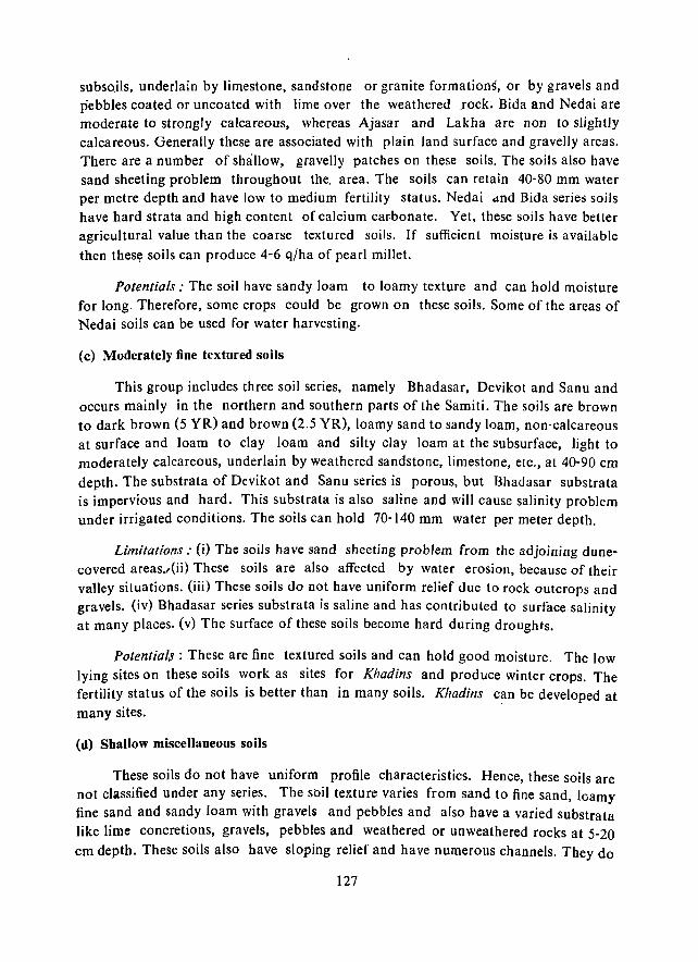
subsQils, underlain by limestone, sandstone or granite formations, or by gravels and pebbles coated or uncoated with lime over the weathered .rock. Bida and Nedai are moderate to strongly calcareous, whereas Ajasar and Lakha are non to slightly calcareous. Generally these are associated with plain land surface and gravelly areas. There are a number of shallow, gravelly patches on these soils. The soils also have sand sheeting problem throughout the. area. The soils can retain 40-80 mm water per metre depth and have low to medium fertility status. Nedai dnd Bida series soils have hard strata and high content of calcium carbonate. Yet, these soils have better agricultural value than the coarse textured soils. If sufficient moisture is available
then thes¥ soils can produce 4-6 q/ha of pearl millet.
Potentials: The soil have sandy loam to loamy texture and can hold moisture for long. Therefore, some crops could be grown on these soils. Some of the areas of Nedai soils can be used for water harvesting.
(c) Moderately fine textured soils
This group includes three soil series. namely Bhadasar, Devikot and Sanu and occurs mainly in the northern and southern parts of the Samiti. The soils are brown to dark brown (5 YR) and brown (2.5 YR), loamy sand to sandy loam, non' calcareous at surface and loam to clay loam and silty clay loam at the subsurface, light to moderately calcareous, underlain by weathered sandstone, limestone, etc., at 40-90 cm depth. The substrata of Devikot and Sanu series is porous, but Bhadasar substrata is impervious and hard. This substrata is also saline and will cause salinity problem under irrigated conditions. The soils can hold 70-140 mm water per meter depth.
Limitations: (i) The soils have sand sheeting problem from the adjoining dunecovered areas.t(ii) These soils are also affected by water erosion, because of their valley situations. (iii) These soils do not have uniform relief due to rock outcrops and gravels. (iv) Bhadasar series substrata is saline and has contributed to surface salinity at many places. (v) The surface of these soils become hard during droughts.
Potential, : These are fine textured soils and can hold good moisture. The low lying sites on these soils work as sites for Khadins and produce winter crops. The fertility status of the soils is better than in many soils. Khadins can be developed at many sites.
(d) Shallow miscellaneous soils
These soils do not have uniform profile characteristics. Hence, these soils are not classified under any series. The soil texture varies from sand to fine sand, loamy fine sand and sandy loam with gravels and pebbles and also have a varied substrata like lime concretions, gravels, pebbles and weathered or unweathered rocks at 5-20 cm depth. These soils also have sloping relief and have numerous channels. They do
127
not have any agricultural value, but are suitable for grazing, -pasture and forestry development.
Limitations: (i) Soil texture is highly variable and have sloping eroded surfaces. (ii) The solum depth is very thin and any crop root can be damaged. (iii) The fertility status is very low. (iv) At places thick sand accumulation causes problems, while at others salinity problem is dominant.
Potentials: These lands are potential for harvesting runoff only. These could also be developed as pasture lands.
(e) Rocks and hills
These are completely barren and occur scatteredly in the eastern part of the area. Their values are mainly for mining of industrial, building and road construction materials. The runoff generated from the hills could be used for agriculture.
Land use capability
Because of extreme aridity and scarcity of water, the soils of Sam Panchayat Samiti are not suitable for regular cropping, except in the Khadin areas which are assigned class III category (Table 19; Fig. 26). The medium and fine textured soils are under class IV category, or the marginal lands, where cultivation is not possible every year due to severe climatic limitations, even though the soils have high moisture holding capacity. Coarse textured soils are classified as class VI lands with c, s, ea and sh sub-classes. These lands are not totally suitable for crop production, but could be put under permanent pasture or forestry plantation, because of severe climatic, soil, wind erosion and root zone limitations. Shallow, gravelly miscellaneous soils have very severe root zone limitations and are completely droughty. These are not fit for cultivation and could be best utilized as permanent grazing lands Rocks and hills in the Panchayat Samiti area are put under class VIII R lands. These could be utilized as quarries (Fig. 26; Table 19).
VEGETATION
Inventory of vegetation resources
Sam Panchayat Samiti supports five major grass cover types (Table 20; Fig. 27). Lasiurus sindicus-Panicum turgidum type occurs predominantly on sand dunes, interdunes and sandy undulating plains and covers the maximum area (70% of the total area). This is followed by L. sindicus-Eleusine compressa type on sandy plains, interdunal and alluvial plains (21.62% area); Dactyloctenium sindicum - Eleusine compressa on buried pediments (5.07% area) and Aris/ida - Oropetium thomaeum on rocky • stony habitat 0.18% area). While Lasiurus sindicus is the natural climax plant of
128
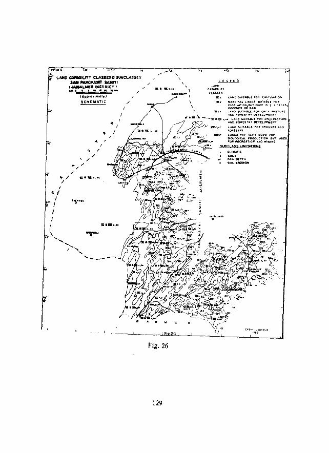
...
LAffO c:MIQDlUTY CLAISe", ,U8CLASSB $AlII I'IIUtCHA"tIII SAIIITI I.lAllALIIIIE'_ DISTRICT} .......... ., .-
(Appror'fllor.) /
SCH£ MATIC /
<0 I' ,/ , ,/
... ,/ ..-/
,. /
~ I /
/
J
/
... / ••• &,.c
I
11..11.,"
/ /
/ ., m~ .c... ,
III~.""',
I Fiq26
\ \
Fig. 26
129
'" w 2 ~ .. <II
!l
2 ..
LEGEND ,,~
'A.PAr;liI..) l' ,
CL.A5Sts m, ..... "0 SUIlA8l.f F()A "UL.T' .... ",IO ..
3ll, fII"JtGllt.A.1 L.AJtDS SVI'l.AS"lf rOF!
~~~~':;~IO~~':' OMCf .", '3 "Tf J:A 5,
CLI ..... TIC . sou .. SOIL DI:"lot SOft.. [.a,.ON
.al"'~.r. 0
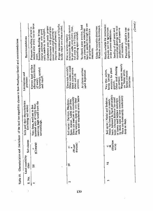
'" C o .~
-0 C u E E 8 u ....
-0 C 0:1
'" C .!: -;;; "0 C u E E o u u ~
'" ·3 "'~ ._ on .... .., u·_ - .... u u
"'''' .... -",._ .DO U'" .... bfj ._ c
]:0 -" -0-CO cd.= ;!!,-'0 rn
'" u '" '" 0:1
U .D
" rn
'0 ';d
uE g
::: -
c .~ C -0 o·_ .,-cd'U; ",0 u'" u u ",-0
15.-0 _c <~
130
",-0 co 00. .- 0 --"'u "> .~.g CI.)CI.)
:D.D 0:1"1:)
;:;""5 0 0 > u
~.e CI.)"1:)
"1:)'" c-'" :>~
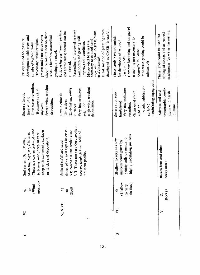
"2 '" 0
C'j :; ·~o-u u ~ ~
~ '" B.D '" "0 Et c
c .. r::
-0 E .. ... '" ., ~ c. r:: .. . ~ ~ .. ~::o .~ .~ .. :::s CD(/)
'" "5 o ..c '"
131
'" r:: o N
;!: .2 os ..c til
~ .. .. > £
-->-
>. ..c c. '" .. CD o Co
£
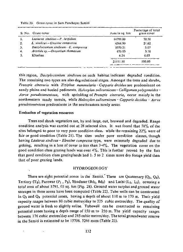
Table 20. Grass cover in Sam Panchayat Samiti
s. No. Grass cover
I. Lasiurus sindicus-P. turgidum 2. L. sindicus-E!eusifle compressa 3. Dactyloctcn;um silldicum-E. compressa 4. Aristida sp.-Oropetium thomaeum
5. Khadins
Area in sq. km
14799.00
4564.90
1070.21 670.83
6.24
21111.18
Percertage of total grass cover
70.10
21.62 5.07 3.18
0.03
100.00
this region, Dactyloctenium sindicum on such habitat indicates degraded condition. The remaining two types are also degradational stages. Amongst the trees and shrubs, Prosopis cineraria with Ziziphus nummularia - Capparis decidua are predominant on sandy plains and buried pediments. Haloxylon salicornicum - Calligonum polygonoides -Aerva pseudotomentosa, with sprinkling of Prosopis cineraria, occur mainly in the northwestern sandy terrain, while Haloxylon salicornicum - Capparis decidua - ~erva
pseudotomentosa predominate in the southeastern sandy areas.
Evaluation of vegetation resources
Trees and shrub vegetation are, by and large, cut, browsed and degraded. Range condition analysis was carried out at 28 selected sites. It was found that 78% of the sites belonged to poor to very poor condition class, while the remaining 22% were of fair or good condition (Table 21). The sites under poor condition classes, though having Lasiurus sindicus - Eleusine compressa type, were extremely degraded due to grazing, resulting in a loss of cover to less than 3-4%. The vegetation cover on the good condition class grazing lands was over 4%. This is further proved by the fact that good condition class grazinglands had 1. 5 to 2 times more dry forage yield than that of poor grazing lands.
HYDROGEOLOGY
There are eight potential zones in the· Samiti.· These are Quaternary «(h, Q2),
Tertiary (T2), Parewar (PI, P2), ~hadasar (Bdl, Bd2) and Lathi (LI, L2), covering a total area of about 5791. 03 sq. km (Fig. 28). Ground water surplus and ground water storages in these zones have been computed (Table 22). Tube wells can be constructed in Ql and Q2 potential zones, having a depth of about 110 m to 170 m. Their yield capacity ranges between 80 cubic me"tre~/day to 225 cubic metres/day. The quality of ground water is fresh to slightly saline. Tubewell can be constructed in remaining potential zones having a depth range of 150 m to 250 m. The yield capacity ranges between 176 cubic metres/day and 285 cubic metres/day. The total groundwater reserve in the Samiti is estimated to be 15706. 5266 mcm (Table 23).
132
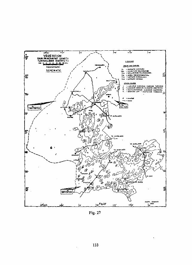
VEGETATION S"1111 ""NCH"Y"T SAUlT! (""'SALIIII£R DISTRICT) ._ It 0 • 0 , • ., Iall ...
(Appro.IMdte)
SCHEMATIC
I J
I I
f
I i,
,,' /"
/' /.",-"
./ ./
/
Fig. 27
133
lOs • ,RosaP'1 CIM.r."AR!A .... ~ ... f,.LOlCYLON !AUCORfiiC"
• UL,-,GO""" "01..'1'40"010['1 • AlEItVA ... r:UDOTO .. INTO'A • loll.",,'1 MU'OUU.AIlIIA
• t.t.pp"~11 OECIDUA
cuss eoaft J, • A.. ... IU~U. 5IftIUCUI •• a1Ireuli ns.GIOUIII 2. -LA-SIURUS s.lMO'CUS~t.LI.U$t"'( c:ototPflU:S .. S, • " .. ,TYL.OC1fNtUIf- (l[USfH! caIlP"ElSA
• <Ul11"'O,," S .. P.
21 o·
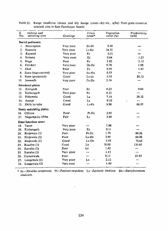
Table_2l. Range condition classes and dry forage (oven-dry wt., q/ha) froin grass covers at selectcd sites in Sam Panchayat Samiti
S. Habitat and Grass Vegetation Productivity No. sampling siles Gradings cover* cover (%) (q/h)
Buried pediments 1. Baroragaon Very poor EC-Pt 0.58 2. Sanwata Very poor Ls-Ec 14.32 3. Raymal Very poor Ec 0,31 4. Sultana Very poor Ec 0.64 1.23 5. Naga Poor Ec 2.82 2.12 6. Devikot Very poor Ds-Ec 0.78 1.08 7. Ekal Poor Ec 0.95 1.67 8. Sanu (unprotected) Very poor Ec-Ds 0.55 9. Sanu (protected) Good Ls-Ec 3.32 29.12
10. lawandh Very poor Ec-Ds 2.79
Intcrdunal pIll ins 11. Ramgarh Poor Ee 0.22 0.64
12. Kishangarh Very poor Ec 0.21 13. Pithewala Good Ls 7.14 28.32 14. Asutar Good Ls 9'10 15. Ditta ka toba Good Ls-Ec 9.88 86.97
Sandy undulating plains 16. Chhore Poor Pt-Ee 2.95 17. Nagaraja ka tibba Fair Ls 3.60
Dune-Interdune areas 18. Tanol Very poor 1.96
19. Kishangarh Very poor Ec 0.11
20. Binjewala (I) Poor Pt-Ec 1.79 60.26
21. Binjewala (2) Poor Ls-Ds 3.95 64.26
22. Binjewala (3) Good Ls-Ds 3.95 73.63
23. Ranahu (1) Good Ls 10.00 130.92
24. Ranahu (2) Poor Ls 1.62
25. Ranahu (3) Very poor 1.15
26. Gamnev.ala Poor 0.11 67.97
27. Longewala (1). Very poor Ls 2.12
28. Longewala (2) Very poor 1.90
* Ec-E/eusine compressa; Pt-Panicum turg/dum; Ls-Lasiurus sindiclls; Ds-Dacty/ocfenium
sindicum.
134
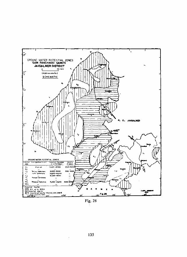
. z.-GROUND WATER POTENTIAL ZONES
SAM PANCHAYAT SAMITI JAISALMER DISTRICT
,,-0'
15'
'-____ .... 2' I(IIIS
(Appro. una;. )
SCHEMATIC
GAOUNOWATE~ POnWT1AL ZONES
POt."tlOl H~d'OQeoloqcol un,'
""" 0, AJluw'w'" 0, T, TIrIIOf)' SaNI.ICI'I,
" Lot'" ScUICflto~
" A:Jrl\llO,·SOlld.ton. P,
P, BO, Elhaalll!(lr Scnsda,.
. B02
Polel'l'lOI AQlllt.,
lIIIl [C w£l 10 6000 Non PotentIal Aqulf.r
£.p.d.d ~e_" ,,, ll'SI'rtc:..n
15000 - 2OOC()
~p:y:;.~
>KJpOO-W_ IO,CCO-I~
e,OOO-"i.OfXX)
~ IlUulllcll'" aQulrl' ,"lell"",IO. 'l .....
4000-
69 I\~ ". Salln'" 0.110 4~' O·
P. S. JAiIALIiIDI
. ' Fig. 28
135
.i
\. (
~ -, ...... >'"' ~ ,,' \\
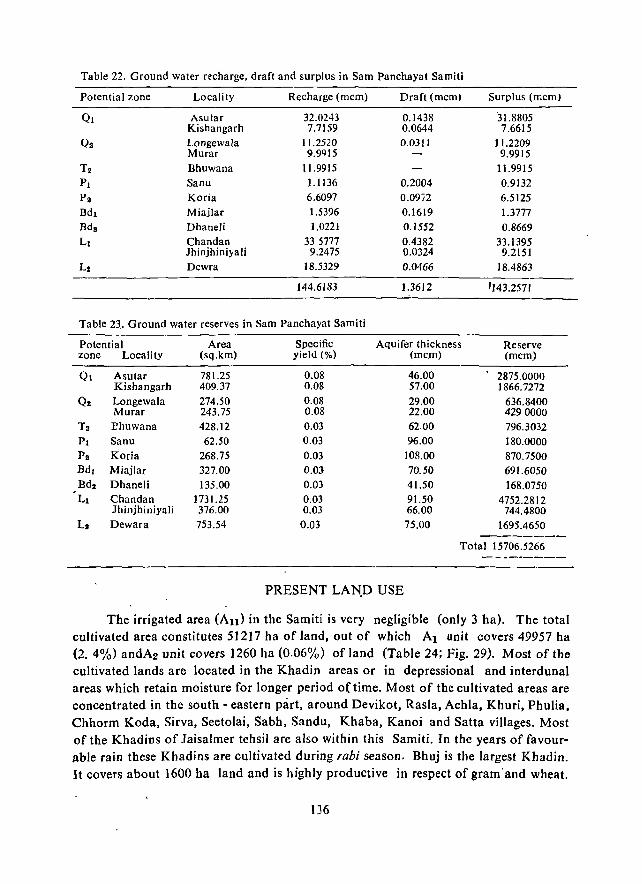
Table -22. Ground water recharge. draft and surplus in Sam Panchayat Samiti
Potential zone Locality Recharge (mcm) Draft (mcm) Surplus (mcm)
QI Asular 32.0243 0.1438 31.8805 Kishangarh 7.7159 0.0644 7.6615
Os Longewala 11.2520 0.0311 11.2209 Murar 9.9Q15 9.9915
T2 Bhuwana 11.9915 11.9915 PI Sanu 1.1136 0.2004 0.9132
Pa Koria 6.6097 0.09,2 6.5125 Bdl Miajlar 1.5396 0.1619 1.3777 Bda Dhaneli 1.0221 0.1552 0.8669 Ll Chandan 33 5777 0.4382 33.1395
Jhinjhiniyali 9.2475 0.0324 9.2151 L! Dewra 18.5329 0.0466 18.4863
144.6183 1.3612 '143.2571
Table 23. Ground water reserves in Sam Panchayat Samiti
Potential Area Specific Aquifer thickness Reserve zone Locality (sq.km) yield (0;.) (mcm) (mcm)
QI Asular 781.25 0.08 46.00 2875.0000 Kishangarh 409.37 0.08 57.00 J866.7272
Q. Longewala 274.50 0.08 29.00 636.8400 Murar 243.75 0.08 22.00 4290000
Ta l?huwana 428.12 0.03 62.00 796.3032 PI Sanu 62.50 0.03 96.00 180.0000 P 2 Koria 268.75 0.03 108.00 870.7500 Bd l Miajlar 327.00 0.03 70.50 691.6050 Bd2 Dhaneli 135.00 0.D3 41.50 168.0750 , LI Chandan 1731.25 0.D3 91.50 4752.2812
Jhinjhiniyali 376.00 0.03 66.00 744.4800 LI Dewara 753.54 0.03 75.00 1695.4650
-------Total 15706.5266
---------
PRESENT LAN.D USE
The irrigated area (An) in the Samiti is very negligible (only 3 ha). The total cultivated area constitutes 51217 ha of land, out of which Al unit covers 49957 ha (2. 4%) andA2 unit covers 1260 ha (0.06%) of land (Table 24; Fig. 29). Most of the cultivated lands are located in the Khadin areas or in depressional and interdunal areas which retain moisture for longer period o(time. Most of the cultivated areas are concentrated in the south - eastern part, around Devikot, RasIa, Achla, Khuri, Phulia, Chhorm Koda, Sirva, Seetolai, Sabh, Sandu, Khaba, Kanoi and Satta villages. Most of the Khadins of laisalmer tehsil are also within this Samiti. In the years of favourable rain these Khadins are cultivated during raM season. Bhuj is the largest Khadin. It covers about 1600 ha land and is highly productive in respect of gram· and wheat.
136
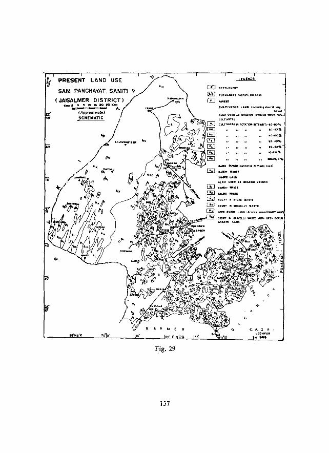
PRESENT LAND USE
Fig. 29
137
8[TTLI"[NT
.. UMunT P.tSTlJIIE OR ORAH
~~LT;V"'TED LAIID Unelll4ing .110.,8 rOlla
rdo.)
ALIO USED .:..J G..AI!". Cfl.Ot;tcO \¥W[N N
CI.l'LTiV.aT'D
CIJLTIV.lUO IN Rar"r,OfI .TIId'TT .o-eo~
'0.1::)"" 40-GO%
,0-40","
20-10%
10-20%
,"fC)T W"STE .......... .., ALia uno .... MAZING IIR0U4D
UJCIY. "'ITI
ROCKY • 1701(£ W.lSTE
STOIfY • UAWLLT ."In:
c. A.. Z R I oJOCHP'Uft I,. ,~ ••
J <ii x w ...
Among the wastelands the sandy wastes (HI) cover the largest area of 1823638 ha (864%). Out of it 46.5% area lies under BIX (sandy waste with open scrub) which ha3 a good grass cover of Lasiurus sindiclls. The area to the west of Bhuttewala. Bada, Kishangarh. Tanot, Longewala, Dhanana, Lunar and Myajlar is covered with bare sand dunes (8 1) or sand dunes with open scrub. The area from Sultana to Lunar has a good cover of LasillrllS sindicus and is considered as a highly fodder productive area. If properly developed it can provide fodder not only for the livestock of Jaisalmer district but also to the livestock of surrounding districts.
The rocky and stony wastes (83) cover about 28,736 ha (1.4%) area of the Samiti and are scatteredly distributed. These are mostly located around Ramgarh, to the east of Bhuj and south of Bhuj. Gravelly wastes (B4) cover 6.8% area around Bhuj Khadin, to the west of Sanu and Lanela and near Devikot, Randha, east of Phulia and Pithal villages. Gravelly wastes with scrub and grass cover (84 X) occur around Ramgarh, and in some scattered pockets, covering about 38342 ha (J .3%) of Jand. It is utilized for grazing purposes for the livestock. The "forest" covers an area of 1840 ha (0.09%) and lies in National Desert Park. but is in a degraded condition.
Area not available for cultivation includes the area under settlements, roads, water features and some tourist places, covering about 1.6% area of the Samiti.
Table 24. Present land use in Sam Panchayat Samili
Land use categories Area in ha Percentage of total area
I. Double cropped area (All) 3
2. Single cropped (AI) (intensity of cultivation 80-100%) 49957 2.4 3. Single cropped (A2) I intensity of cultivation 60-80%) 1260 0.1 4. Sandy waste (BI) 842332 39.8 5. Sandy waste with open scrub (BIX) 981306 46.4 6. Rocky and stony waste (B3) 28736 1.4
7. Gravelly waste (B4 ) 142578 6.8 8. Gravelly waste with open scrub (B4X) 28342 1.3 9. forest 1840 0.1
10. Area not available for cultivation 34774 1.6
Total 2111128 100.0
RECOMMENDA nONS
Based on the resource characteristics and their assessment the following broad
recommendations could be framed.
1) Highly efficient aeolian processes and extreme vulnerability of the sandy terr
ain in the Samiti indicate that disturbances caused to the naturally stabilized sand dunes can lead to faster reactivation of the dunes and engulfing of more areas with mobile dunes. Such phenomena are now noticed in the vicinity of villages where
138
devegetation of dunes and interdunes is loosening the structure of dune sand and increasing the sand mobility. Hence, the present activities related to canal construction should also take into account quick restoration of the ecology of the dunes and sandy plains in tbe areas of earth-work.
ii) In parts of the Samiti new dunes are forming spontaneously through a series of mobile bedforms. The initial identifiable bedform is a linear arrangement of isola
ted barchans, moving from SSW or SW to NNE or NE. Although the barchans temporarily obstruct roads and other structures they move away faster unless ubstructed
at their lee. Any obstruction to these crescent - shaped dunes may lead to attraction of more sand and engulfing of the structure. Hence. rather than checking the isolated barchans these may be allowed to pass. In case of coalescing barchanoids the corridors· between the ridges could be used temporarily. Avoidance of such area is economical than trying to counter their advll nee. The megabarchanoid jitlds in the southwest (Fig. 16), although containing highly mobile dunes, do not advance menacingly. However, over - exploitation of the resources of the stable dunes in the region is leading to the creation of new fields of mobile barchanoids (e.g. to the west of Sam). Such trends could only be checked through much restricted use of the vegetation resources of the
dunes.
iii) The natural vegetation of the dunes and sandy plains, especially the Sewan grass (Lasiurus sindicusl and the bushes of Calligonum po/)'gonoides are gOud sand binders. Even a 30% cover of the vegetation can substantially reduce the mobility of sand. Hence, efforts should be made to protect and utilize these and other plants through scientific range care· The present practice of unmanaged utilization and destruction must be discouraged, atleast for the sake of sand stabilization.
iv) The sui-table plant species for sand dune stabilization in the canal command area (where water is available) and outside the command areas are as mentioned in chapter XV. Local grasses and shrubs should be given preference to trees in the noncommand and command areas.
v) The areas with coarse textured soils should be put under permanent pasture. Agricultural activity may be discouraged.
vi) In the medium textured soils land levelling is to be carried out for crop prociucticn. The soils need to be protected from the coarser blown sand from the sand dunes in their surroundings. Proper field bunding is to be done to conserve rain water
and water from the gravelly areas are to be guided to the fields. Addition of FYM to the soils can improve the porosity.
vii) The fine textured soils can be used for new khadin development. Field bunding and levelling of fields should be done so that rain water can be spread uniformly. Sand sheeting on these lands should be checked. If irrigation is practised, heavy watering should be avoided. Th~ Bhadasar series soils are unfit for irrigation, because of their saline substrata.
1:.;9
viii) The shallow, gravelly I~nds should be brought under permanent pasture to check further degradation. Apart from run-off harvesting these lands should be brought under silvipastoral programme.
ix) The existing production potential of good condition class grass covers can be increased two - fold by following proper range care methods and reboisement programmes. Such programmes. with their estimated cost and return, are enumerated in Tables 25 to 35. Thus, it is possible to improve the range condition, its productivity, browse resources and general environment, besides providing remunerative livestock production. Plants of economic importance such as Tumba (Citru/lus colocynthis), can be gainfully exploited.
x) The ephemeral present streams, with coarse bedload, do not have enough surface and subsurface water potentials, especially because of the rainfall constraint. However, beneath the unconsolidated riverine deposits the consolidated riverine conglomerate and/or parent formation creates a subsurface barrier for water percolation and, hence, wh'!rever the granular overburden is thick enough a perched water body develops after the rains. This water, although brackish, is tapped at many places by the villagers through open, shallow dug-wells (berries), but need to be maintained properly and periodically treated to check contamination.
xi) In the western part of the Samiti the acute problem of drinking water could also be partially solved through construction of tankas. Some of the village~, selected for tanka construction and communicated to PRED, Government of Rajasthan, are Meerwala, Navtala, Rabhlau Fakiro:lwala, Muhar, Chhaganiyo ki Basti, Khariya, Dorau, Geraja, Suwar, Kulatala, Mehboob ka Par and Bhutonwali. All these villages b'ave high sand dunes, interspersed with elongated interdune plains. The run-off generated from the plains and collected from the slopes of the dunes, could be stored in tankas constructed in the natural low-lying areas within the interdunes, especially in the central part of the interdunes. It is to be noted that, because of the elongated shape of the interdunes, the time of concentration of water in them is more. The construction details of the tankas are given in Chapter XV.
xii) 'The bOuried former course of the Saraswati along the westernmost part of the Samiti (Fig. 8), roughly through Kishangarh, Ghantialji ka Mandir, west of Gnotaru, west of Shahgarh and Babuwali, could be explored for ground water. A few wells along it have proved successful. Futner drilling and pump testing may provide enough information on its potentiality and recharge condition. In general, the zones
Ql and Q2 are the most potential a~eas, having yield capacity of 80 to 225 cubic
metres/day. The average depth to water ranges from 110 m to 170 m.
xiii) In the other potential zones (Table 22, Fig. 28) the yield ranges from 176 c.ubic metres to 285 cubic metres and the tube wells can tap water at 150 m to 250 In
depth.
140
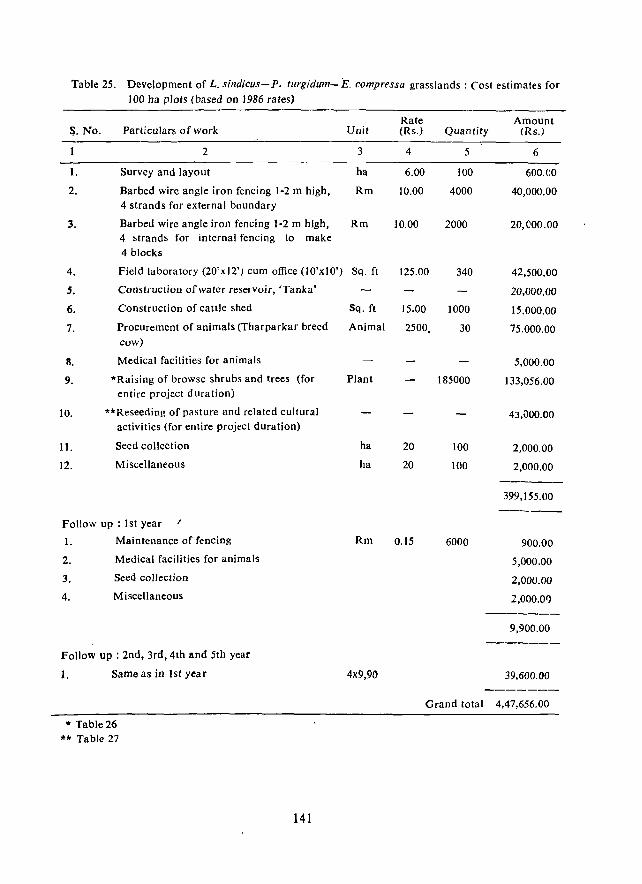
Table 25. Development of L. sindicus-P. turgidum-E. compressa grasslands: Cost estimates for 100 ha plots (based on 1986 rates)
S. No. Particulars of work
2
1. Survey and layout
2. Barbed wire angle iron fencing 1-2 m high, 4 strands for external boundary
3. Barbed wire angle iron fencing 1-2 m high, 4 strands for internal fencing to make 4 blocks
4. Field laboratory (20'xI2') cum office (lO'xIO')
5. Construction of water reservoir, 'Tanka'
6. Construction of cattle shed
7. Procurement of animals (Tharparkar breed
cow)
8. Medical facilities for animals
9. '"Raising of browse shrubs and trees (for entire project dUration)
10. ""Reseeding of pasture and related cultural activities (for entire project duration)
11. Seed collection
12. Miscellaneous
Follow up : 1st year
1. Maintenance of fencing
2. Medical facilities for animals
3. Seed collection
4. Miscellaneous
Follow up : 2nd, 3rd, 4th and 5th year
1. Same as in 1st year
* Table 26
"" Table 27
141
Unit
3
ha
Rm
Rm
Sq. ft
Sq. ft
Animal
Plant
ha
ha
Rm
4x9,90
Rate Amount (Rs.) Quantity (Rs.)
4 5 6
6.00 100 600.00
10.00 4000 40,000.00
10.00 2000 20,000.00
125.00 340 42,500.00
20,000.00
15.00 1000 15.000.00
2500, 30 75.000.00
5,000.00
185000 133,056.00
43,\)00.00
20 100 2,000.00
20 100 2,000.00 ------399,155.00 ------
0.15 6000 900.00
5,000.00
2,000.00
2,000.01) -------
9,900.00 _------
39,600.00 -------
Grand total 4,47,656.00
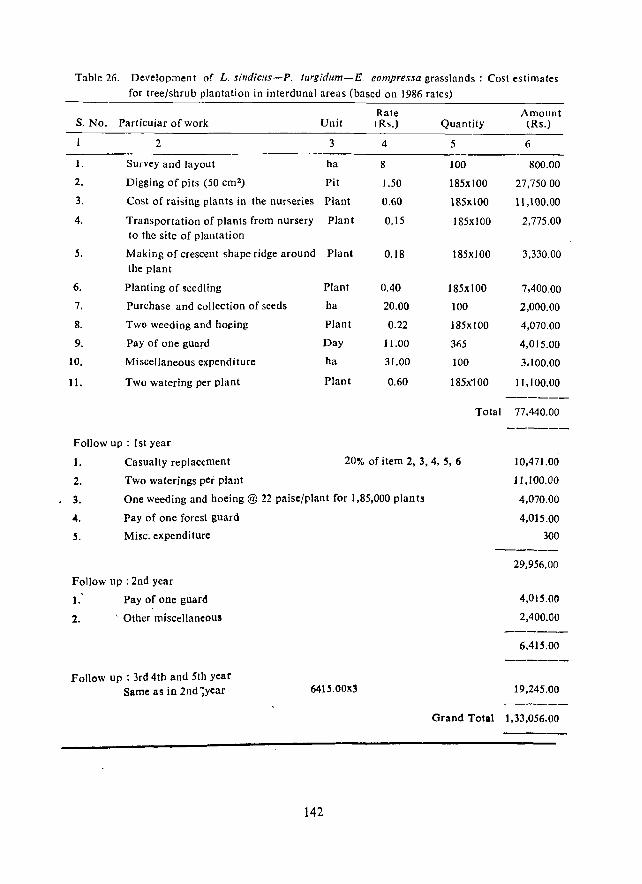
Table 26. Development of L. sindiclIs-P. tllrgidllm-E. eompressa grasslands: Cost estimates
for tree/shrub plantation in interdunal areas (based on 1986 rates)
Rate Amount S. No. Particuiar of work Unit cRs.) Quantity (Rs.)
2 3 4 5 6
1. Survey and layout ha 8 100 800.00
2. Digging of pits (50 cm2) Pit 1.50 185xl00 27,75000
3. Cost of raising plants in the nurseries Plant 0.60 185)(100 11,100.00
4. Transponation of plants from nursery Plant 0.15 185xl00 2,775.00 to the site of plantation
S. Making of crescent shape ridge around Plant 0.18 185xl00 3,330.00 the plant
6. Planting of seedling Plant 0.40 185xl00 7,400.00
7. Purchase and collection of seeds ha 20.00 100 2,000.00
8. Two weeding and hOl;!ing Plant 0.22 185xl00 4,070.00
9. Pay of one guard Day 11.00 3fi5 4,015.00
10. Miscellaneous expenditure ha 31.00 100 3.100.00
11. Two watering per plant Plant 0.60 185)(100 11,100.00 ------
Total 77.440.00
------Follow up : 1st year
1.
2.
, 3.
-4.
5.
Casualty replacement 20% of item 2, 3, 4, S, 6 10,471.00
11,100.00
4,070.00
4,015.00
300
Two waterings per plant
One weeding and hoeing @ 22 paise/plant for 1,85,000 plan Is
Pay of one forest guard
Misc. expenditure
Follow up : 2nd year
1: 2.
Pay of one guard
, Other miscellaneous
Follow up : 3rd 4th and 5th year Same as in 2nd ~year 64IS.00x~
142
29.956.00
4,015.00
2,400.00
6,415.00
19,245.00
Grand Total 1,33,056.00
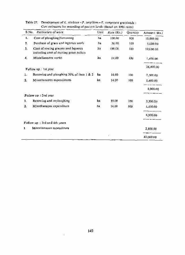
TaMe 27. Development of L. ,~indicus -Po turgidum-E. compressa grasslands: Cost estimates for reseeding of pas\ure lands (Based on 1986 rates)
S,No. Particulars of work
1. Cost of ploughing/furrowing
2. purchase of grass and legumes seeds
3. Cost of sowing grasses and legumes including cost of making grass pellets
4. Miscellaneous works
Follow up : ] st year
Unit
ha
ha
ha
ha
1.
2.
Resowing and ploughing 50% of item I & 2 ha
Miscellaneous expenditures ha
Follow up : 2nd year
1.
2.
Resowing and repJoughing
Miscellaneous expenditure
Follow up : 3rd and 4th years
1. Miscellaneous expenditure
143
ha
ha
Rate (Rs.)
100.00
50.00
100.00
14.00
14.00
14.00
35.00
14.00
Quantity
100
100
100
100
]00
100
]00
100
Amount (Rs.)
10,000.00
5,000,00
10,COO.00
1,400,00
26,400.00
7,500.00
].400.00
8,900.00
3,500.00
1,400.00
4,900.00
2,800.00
43,000.00
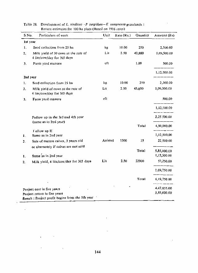
Table 28. D~velopment of L. sindicus-P turgidum-E compre~sa grasslands: Return estimates for 100 ha plots (Based on 1986 rates)
S No. Particulars of work Unit Rate (Rs.) Quantity Amount (Rs)
lsi year
1. Seed collection from 25 ha kg 10.00 250 2,500.00
2. Milk yield of 30 cows at the rate of Lit 2.50 43,800 1,09,500.00 4 lits/cow/day for 365 days
3. Farm yard manure eft 1.09 500.00 ------
1,12,500.00
2nd year ------1. Seed collection from 25 ha kg 10.00 250 2,500.00
2. M ilk yield of cows at the rate of Lit 2.50 43,800 1,09,500.00
4 lits/cow/day for 365 days
3. F;um yard manure cft 500.00 ------
1,12,500.00 ------
Follow up in the 3rd and 4th year 2,25500.00
(same as in 2nd year) ------Total 4,50,000.00
roJlow up II ------1. Same as in 2nd year 1,12,500.00
2. Sale of mature calves, 3 years old Animal 1500 15 22,500.00
or alternately if calves are not sold ------Total 5,85,000.00
1. Same 'as in 2nd year 1,12,500.00
2. Milk yield, 4 Hts/cow/day for 365 days Lit 2.50 22900 57,250.00 ------
1,69,750.00 ------
Total 6,19,750.00 ------
Project cos t in five year~ 4,47,655.00
Project return in five years 5,85,000.00
Result: Project profit begins from the 5th year
144
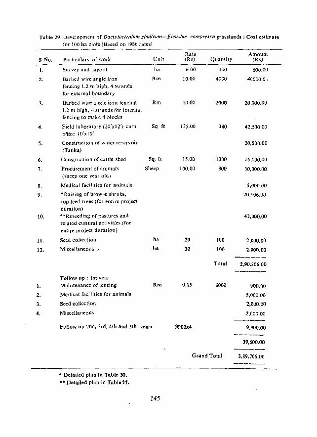
Table 29. Deve!opment of Dacty[octmium sindicum-Eleujine comprtUQ grasslands: Cost estimate for 100 ha Plots (Based on 1986 ratesl
Rate Amount S No. Particulars of work Unit (Rs) Quantity IRs)
I. Survey and layout ha 6.00 100 600.00
2. Barbed wire angle iron Rm 10.00 4000 40000.0, fencing 1.2 m high, 4 Hrands for external boundary
3. Barbed wire angle iron fencing Rm 10.00 2000 20.000.00 1.2 m high, 4 strands for internal fencing to make 4 blocks
4. Fidd labora tory (20'x 12') cum Sq ft 125.00 340 42,500.00 office 10'x 10'
5. Construction of water reservoir 20,000.00 (Tanka)
6. Cc·nstruction of cattle shed Sq. ft 15.00 1000 15,000.00
7. Procurement of animals Sheep 100.00 300 30,000.00 (sheep one year old I
8. Medical facilities for animals 5,000.00
9. *Raising of brow,e shrubs, 70,106.00 top feed trees (for entire project duration)
10. **Reseeding of pastl)res and 43,000.00 related cultural activities (for entire project duration)
I}, Seed collection ha 20 100 2,000.00
12. Miscellaneous / ha 20 100 2,000.00 ------
Total 2,90,206.00 ------
Follow up : 1st year
1. Maintenance offencing Rm O.IS 6000 900.00
2. Medical fac'lities for animals 5,000.00
3. Seed collection 2,000.00
4. Miscellaneous 2,000.00 ------
Follow up 2nd, 3rd, 4th and sth yean 9900x4 9,900.00 ------
39,600.00 ------
Grand Total 3.89,706.00 ------
• Detailed plan in Table 30 • •• Detailed plan in Table 27.
145
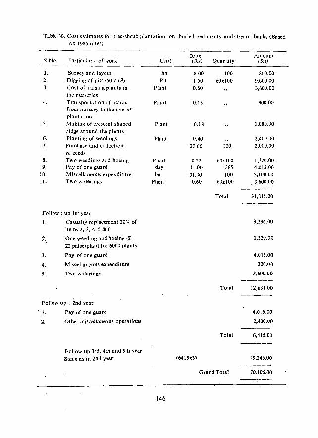
Table 30. Cost estimates for tree-shrub plantation on buried pediments and stream' banks (Based on 1986 rat es)
Rate Amount S.No. Particulars of work Unit (Rs) Quantity (Rs)
1. Survey and layout ha 8.00 100 800.00 2. Digging of pits (50 cm3 ) Pit 150 60xl00 9.000,00 3. Cost of raising plants in Plant 0.60 .. 3,600.00
the nurseries 4. Transportation of plants Plant 0.15
" 900.00
from nursery to the site of plantation
5. Making of crescent shaped Plant 0.18 1,080.00 ridge around the plants
6. Planting of seedlings Plant 0.40 " 2,400.00
7. Purchase and collection 20.00 100 2,000.00 of seeds
8. Two weedings and hoeing Plant 0.22 60xl00 1,320.00 9. Pay of one guard day 11.00 31'5 4,015.00
10. Miscellaneous expenditure ha 31.00 100 3,100.00 11. Two waterings Plant 0.60 60xl00 . 3,600.00
------Total 31,815.00
------
Follow: up 1st year
J. Casualty replacement 20% of 3,396.00
items 2, 3, 4,5 & 6
2. One weeding and hoeing @ 1,320.00
22 paise/plant for 6000 plants
3. Pay of one guard 4,015.00
4. Miscellaneous expenditure 300.00
5. Two waterings 3,600.00 ------
Total 12,631.00 -----_
Follow up ; 2nd year
'}. Pay of one guard 4,015.00
2. Olher miscellaneoUS operations 2,400.00 ----_-
Total 6,415.00
------Follow up 3rd, 4th and 5th year Same as in 2nd year (64ISx3) 19,245.00
------Grand Total 70.106.00
,-----
146
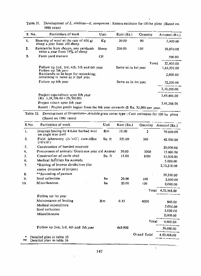
Table 31. Development of L. sindicus-E. compreSSQ : Return estimate for 100 ha plots (Based on. 1986 rates)
S. No. Particulars of work Unit Rate (Rs.) Quantity Amount (R s.)
1.
2.
3.
Shearing of wool at the rate of 400 gf Kg sheep a year from 100 sheep Ramlambs from sheeps, one ramlamb Sheep
twice a year from 75% of sheep Farm yard manure eft
Follow up 2nd, 3rd, 4th, 5th and 6th year Follow up 7th year Ramlambs to be kept for restocking; remaIning is same as is 2nd year Follow up 8th year
30.00 80 2,400.00
200.00 150 3D,OCO.00
.500.00
Total 32,9CO.00 Same as in 1st year 1,64,500.00
2,900.00
Same as in I st year 32,200.00
2,33,200.00
Project expenditure upto 8th year 3,69.406.00 (Rs. 3,39,706.00+29,700.00) Project return upto 8th year 3,91,206.00 Result: Project profit begins from the 9th year onward~ @ Rs. 32,000 per year.
Table 32. Development of Oropelilim-AriMida grass cover type: Cost estimates for 100 ha plots (Based on 1986 rates)
S.No.
I.
2.
Particulars of work
Internal fencin'g by 4-Line barbad wire on angle iron post Field laboratory (21.:xI2'; cum office (IO'xIO' ) Construction of bunded reservoir
Unit
Rm
Sq. ft
Rate (Rs.)
10.00
125.00
3. 4. 5. 6. 7.
Procurment of animals: Goats one year old Animal 50.00 Constructi on of cattle shed Sq. ft 15.00
8. 9.
10.
Medical faCilities for animals *Raising of browse shrubs/tree (for entire duration of project) ** Reseeding of pasture Seed collection Miscellaneous
FoJlo\y up 1st year Maintenance of fencing Medical expendi ture Seed collection Miscellaneous
Follow up 2nd, 3rd, 4th and 5th year
* Detailed plan in table 33 ... Detailed plan in table 34
ha ha
Rm
147
20.00 20.00
0.15
4x9,900
Quantity Amounl (Rs.)
2
340
3000 ICOO
100 100
20.000.00
42.500.00'
20,000.00 15,00000 15,OCO.00 5.000.00
2,i3.218.00
39,250.00 2,000.00-2,000.00
Total 4,32,968.00
6000 900.00 5.000.00 2,000.CO 2,000.00
-------Total 9,900.00
39,600.00 -------
Grand Total 4,83.468.00 -------
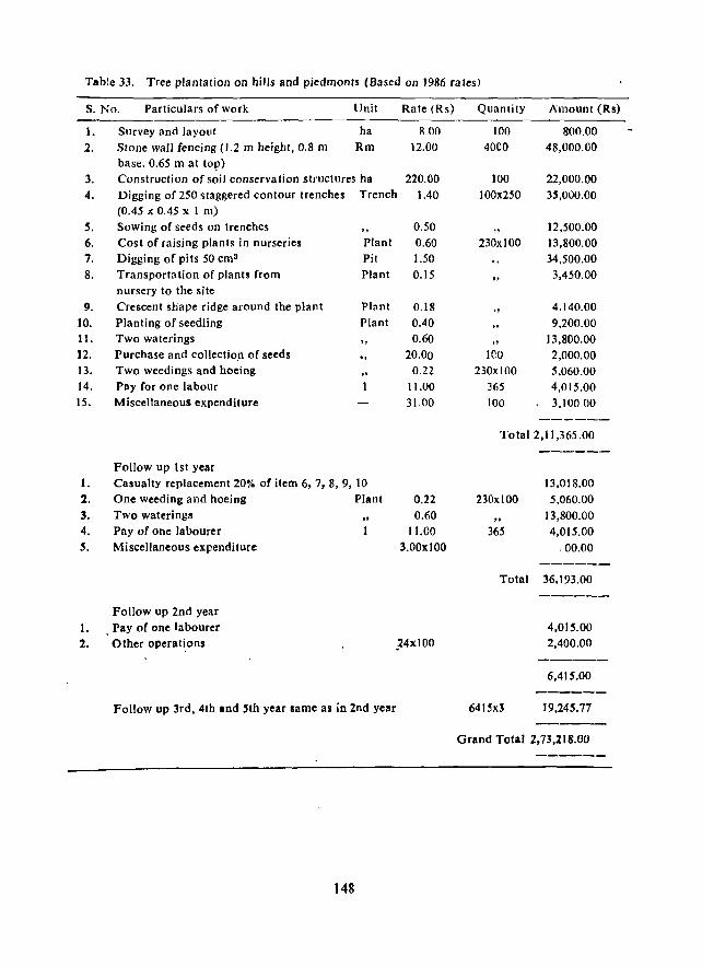
Table 33. Tree plantation on hills and piedmonts (Based on 1986 rates)
S. No. Particulars of work Unit Rate (Rs)
1. Survey and layout ha 8.00
2. Stone wall fencing (1.2 m height, 0.8 m Rm 12.00 base. 0.65 m at top)
3. Construction of soil conservation structures ha 220.00 4. Digging of 250 staggered contour trenches Trench 1.40
(0.45 x 0.45 x I m)
5. Sowing of seeds on trenches O.SO 6. Cost of raising plants in nurseries Plant 0.60 7. Digging of pits 50 ems Pit 1.50 8. Transportation of plants from Plant 0.15
nursery to the site
9. Crescent shape ridge around the plant Plant 0.18 10. Planting of seedling Plant 0.40 11. Two waterings .. 0.60 12. Purchase and collectio.n of seeds " 20.00 13. Two weedings and hoeing 0.22 14. Pay for one labour 11.00 15. Miscellaneous expenditure 31.00
Follow up 1st year 1. Casualty replacement 20% of item 6, 7, 8, 9, 10 2. One weeding and hoeing Plant 0.22 3. Two watering!
" 0.60
4. Pay of one labourer 11.00 5. Miscellaneous expenditure 3.00x100
1. 2.
Follow up 2nd year Pay of one labourer Other operations ,:24x100
Follow up lrd, 4th and 'th year same as in 2nd year
148
Quantity Amount (Rs)
100 800.00 40CO 48,000.00
100 22,000.00 100x250 35,000.00
12,500.00 230xl00 13,800.00
34,500.00 3,450.00
4.140.00 9,200.00
.. 13,800.00 1CO 2,000.00
230xl00 5,060.00 365 4,015.00 100 3,10000
------Total 2,11,365.00
230xl00
365
Total
641~x3
------
13,018.00 5,060.00
13,800.00 4,015.00
.00.00 ------36,193.00
------4,015.00 2,400.00
6,415.00
19,245.77
Grand Total 2,73,218.00
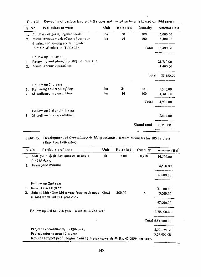
Table 34. Reseeding of pasture land on hill slopes and buried pedimenls CHased on 19F6 rates)
s. No. Parliculars of work Unit Rate lRs) QuaJ.lily Amount (Rs) -----_.-----------------------------------------------------------------------
I. PUrchas" of grass, legume seeds
2. Misc!llaneous work (Cost of"contour digging and sowing seeds included in main schedule in Table 33)
Follow up I SI year
1. Resowing and ploughing 50% of ilem 4,5
2. Miscellaneous operations
Follow up 7nd year I. Resowing and reploughing
2. Miscellaneous experditure
Follow up 3rd and 4th Yfar
1. Miscellaneous expenditure
ha 50
ha 14
ha 35 ha 14
100 5,000.00 100 1,400.00
------Total 6,400.00
------
23,75000
1,400.00 -----_
Total 25,150.00
------
100 3,500.00 100 1,400.00
------Tolal 4,900.00
------
2,800.00
------Grand total 39,250.00
------
Table 35. Development of Oropetium-Aristida grasslands: Return estimates for 100 ha plots (Based on 1986 rates)
S. No. Particulars of work
I. Milk yield @ [it/day/goat of 50 goats
for 365 days. 2. Farm yard manure
Follow up 2nd year
1. Same as in 1st year
Unit
lit
2. Sale of kids (One kid a year ~rom each goat Goat is sold when lad is I year old)
Follow up 3rd to 12th year; same as in 2nd year
Project expenditure upto 121h year Project returns upto 12th year
Rate (Rs)
2.00
200.00
Quantity
18,250
50
Amount (Ra)
36,500.00
5,500.00
37,000.00
37,000.00 10,000.00
n,OOO.OO
4,70.000.00
Total 5,54,000.00
5,22,628.00 5,54,000.00
Result; Project profit begins from 13th year·onwards ® Rs. 47,00('/- per year.
149
CAZRI PUBLICATIONS
No. 1 Desert Ecosystem and its Improvement, pp. 1-387 (1974)
No. 2 Proceedings of Summer Institute on Rodentology (Mimeo), pp. 1-365 (1975)
No. 3 Solar energy utilization research (Mimeo.), pp. 1-48 (I975)
No. 4 Rodent pest management-Principles and Practices,
pp. 1-28 (1976)
No. 5 White grubs and their management, pp. 1-30 (1977)
No. 6 The amazing life in the Indian desert, pp. 1-18 (1977)
No. 7 Geomorphological investiga-tions of the Rajasthan desert, pp. 1-44 (1977)
No.' 8 p'roceedings of Summer Institute on Resource, inventory and landuse planning, pp. 1-373 (1977)
No. 9 Land use classification system in Indian arid zone,' pp. 1-43
(1978)
No. 10 Ecology of the Indian desert gerbil. Meriones hllrrianae, pp. 1-88 (1981)
150
Edited by H.S. Mann
Edited by Ishwar Prakash.
by H.P. Garg
by Ish war Prakash'
by S.K. Pal
by Ishwar Prakash
by Surendra Singh
Edited by K.A. Shankarnarayan
by Arnal ;Kumar Sen
by Ishwar Prakash
No. II Khejri rProsopis cineraria) in in the Indian desert - .its role in agroforestry, pp. 1-78 (1980)
No. 12 The goat In the desert. environment, pp. 1-26 (1980)
No. 13 Bordi (Zizyphus Ilummularia)-A shrub of the Indian arid zone - its role in silvipasture, pp. 1'9~ (1981)
No. 14 Sbeep in Rajasthan, pp. 1-38 (198 1 )
No. 15 Water proofing of field irrigation channels in desert soils, pp. 1-23 (19~Q)
No. 16 Termite pests of vegetation in Rajasthan and their management, pp. 1-31 (1981)
No. 17 Water in the eeo-physiology of desert sheep, pp. 1-42 (1981)
No. 18 Ground water Atlas of Rajasthan, pp. 1-61 (1983)
No. 19 Agro - demographic Atlas of Rajasthan, pp. 1-63 (1983)
No. 20 Soil and moisture conservation for increasing crop production in arid lands, pp. 1-42 (1983)
No. 21 DepJe ed vegefation of desertic habitats: studies on its natural regeneration,' pp. 1-32 (1983)
No. 22 Prosopis juliflora (Swartz) D.C., a fast growing tree to bloom the desert, pp. 1-21 (1983)
151
Edited by H.S. Mann and S.K. Saxena
by P.K. Ghosh and M.S. Khan
Edited by H.S. Mann and S.K. Saxena
by A.K. Sen, P.K. Ghosh, K.N. Gupta and H.C. Bohra
by K.N.K. Murthy, V.C. Issac and D.N. Bohra
by D.R. Parihar:
by P.K. Ghosh and R.K. Abichandani
by H.S. Mann and A.K. Sen
by A.K. Sen and K.N. Gupta
by J.P. Gupta
by Vinod Shankar
by K.D. Muthana and G.D. Arora
No. 23 Arid zone forestry (with special reference to the Indian arid zone), pp. 1-48 (1984)
No. 24 Agro-forestry in arid and semI arid zones, pp. 1-295 (1984)
No. 25 Israeli Babool : Mqrusthal ke liye labhdayak vraksh (Hindi), pp. 1-14 (1985)
No. 26 Desert environment: Conservation and management, pp. 1-124 (1986)
No. 27 Agro- forestry: A judicious use of desert Eco-system by man, pp. 1-40 (1986)
No. 28 Grazing resources of Jaisalmer district : ecology and developmental planning with special reference to sewan grasslands, pp. 1-92 (1987)
No. ~9 Grasshopper pes"ts of grazing land vegetation and their management in Indian desert, pp.i-56 (1987)
No: 30 Improvement and grazing 'management of arid rangelands at Samdari' and Jodbpur, pp. 1-39 (1987)
No. 31 Marukshetra ke Keere va bimariyon aur ullki roktham (Hindi), pp. 1-43 (1987)
No. 32 Package of practices of cultivation of Jojoba (Simmondisa chirien;s) in arid zone, pp. 1-19 (1987)
152
by H.S. Mann and K.D. Muthana
by K.A. Shankarnarayan
by L.N. Harsh and H.C. Bohra
by K.A. Shankarnarayan and Vinod Shankar
by S.P. Malhotra, H.S. Trivedi and Y.N. Mathur
by Vinod Shankar and Suresh Kumar
by D.R. Parihar
by S. K. Sharma
by Satyavir, M.P. Singh and Satish Lodha
L.N. Harsh, J.C. Tewari, Dalip Singh Patwal and G.L. Meena
No. 33 Tanka-A reliable system of rainwater harvesting in the Indian desert, pp. 1-16 (1988)
No. 34 Impact of transfer of agricultural technology in ORP villages (A case study), pp. 1-35 (1988)
No. 35 Chuha prabandh ek avashyakta, kyon aur kaise? (Hindi), pp. 1-24 (1988)
No. 36 Pearl millet in arid zone-a retrospect, pp. I-56 (1988)
No. 37 Water harvesting In arid tropics. pp. t- 68 (1988)
No. 38 Studies on improvement and utilization of rangelands of Jaisalmer region, pp. 1-45 (1992)
153
, by N.S. Vangani, K.D. Sharma and P.C. Chatterji
by K.N.K. Chouhan, R.N. Singh and K.D. Kokate
by A.P. Jain and R.S. Tripathi
by Mahander Singh and
N.L. Joshi
by S.D. Singh
by R.S. Mertia
SOME OTHER PllBLICATOINS FROM CAZRI
Anonymous (1964) Recent Developments in Rajasthan. CAZRljGovt. of India, pp. 1-55.
Kaul, R.N., ed. (1970) Afforestation in Arid Zones. Dr. W. Junk, b. v., The Hague, pp. 1-435.
Anonymous (1971) Proceedings of 1964 Jodhpur Syrnpo<;ium on the Problems of Indian Arid Zone. Govt. of India, New Delhi, pp. 1-495.
Sen, A.K. (1972) Agricultural Atlas of Rajasthan. lCAR, New Delhi, pp. 1-51.
Fitzwater, W.D. and Prakash, I. (1973) Hand Book of Vertebrate Pest C:ontrol. leAR New Delhi, 2nd ed. (1978), pp. 1-95.
Barnett, S.A. and Prakash, I. (1975) Rodents of Economic Importance in India. Arnold-Heinemann, New Delhi, pp. 1-175.
Gupta, R.K. and Prakash, I. (1975) An Environmental Analysis of Thar Desert. English Book Depot, Dehra Dun, pp. 1-484.
Prakash, L and Ghosh, P.K., eds. (1975) Rodents in Desert Environments. Dr. W. Junk, b.v., The Hague, pp. 624.
Anonymous (1977) Arid ZoneResearch in India (Silver Jubilee Souvenir, 1952-1977). CAZRr, pp. 1-135.
Malhotra, S.P. (1977) Socio-economic Structure of Population in Arid Rajasthan. CAZRI, pp. 1-5\.
Muthana, K.D. (1977) Improved Techniques For·Tree Plantation in the Arid Zone, CAZRI, pp. 1-22.
, Taneja, G.C. (1978) Sheep Husbandty in India. Orient Longman Ltd., New Delhi,
pp. 1-159.
Muthana, KD. and Arora, G.D. (1979) Acacia torti/is (rom.) -A promising fast growing tree for Indian Arid ZOl?e. CAZRI. pp. 1-99.
Singh, S.D. and Mann, H.S. (1979) Optimisation of Water Use and Crop Production in an Arid Region. CAZRI, pp. 1-88.
Mann, H.S., ed. (1980) Arid Zone Research and Development. Scientific Publishers, Jod'hpur, pp. 1-531.
154
Parada, R.S., Mann, H.S. and Verma, C.M. (1980) Management of Indian Arid Rangelands. CAZRI, pp. 1;-38.
Anonymous (1983) Outlines of the Technologies for Reconstruction of the Arid Znoe, CAZRL pp. ] -40.
Malhotra, S.P., Gupta, B.S., Goyal, Daulat and Taimni, Vishnu (1983). Population, Land, Crops and Livestock Statistics of Arid Zone of Rajasthan. CAZRI, pp. 1148.
Shankarnarayan, K.A. (1983) SC)cia1 forestry -Its Significance and Scope. CAZRI, pp. 1-26. /
Anonymous (1985) Research Highlights. CAZRI, pp. 1-153.
Shankarnarayan, K.A. and Sen, A. K. (1985) Combating Desertification CAZRI, pp. 1-26.
Shankarnarayan, K.A. and Singh, S. D. (1985) Transfer of Technology to Farmers
Involved in Desert Agriculture. CAZRl Farm Bulletin No. I, pp. 1-28.
Singh, S.D. (1985) Data Base for Managing Water in Command Area (If Indira
Gandhi Canal-Stage II. CAZRI. pp. l-log2.
Singh, S.D., (1985) Development and Management Training Course on Irrigated
Agriculture in Arid Areas. WAPCOS, New Delhi, pp. 1-708.
Prakash, Ishwar and Mathur, R.P. (1987) I'vtanagement of Rodent Pests. ICAR, New
Delhi, pp. 1- 1 83.
Anonymous (1988) Progress in Arid Zone Research: 1952-1987. CAZRI, pp. 1-88.
Ghosh, P.K. and Prakash, Ishwar, eds. (1988) Ecophysiology of Desert Vertebrates. Scientiflc Publishers, Jodhpur, pp. 1-475. ~
Prakash, Ishwar, ed. (1988) Desert Ecology. Scientific Publishers, Jodhpur, pp. 1-313.
Prakash, Ishwar, ed. (1988) Rodent Pest Management. C.R.C. Press, Boca Raton, USA, pp. 1-480.
Shankarnarayan, K.A., ed. (1988) Wastelands Development and Their Utilisation.
Scientific Publishers, Jodhpur, pp. 1-496.
Jain, A P. and Tripathi, R.S. (1988) Major Rodent Pests of Agriculture-an Illustrated Guide. CAZRI, Jodhpur, pp. 1-14.
Angnymous (1989) Taming the Desert-The story of CAZRI. Central Arid Zone Research Institute, Jodhpur, pp. 1-20, with 30 coloured and 6 black and white
photographs.
Anonymous (1989) International Symposium on "Managing Sandy Soils (Abstracts). International Symposium on, "Managing Sandy Soils", held at CAZRI , Jodhpur, February 6-10, 1989. Part I, pp. 1-463. Part II, pp. 465-753.
155
Anonymous (1989) Reviews of Research on Sandy Soils 'in India. International Symposium on, "Managing Sandy SOlis", held at CAZRI, Jodhpur, February 6-10, 1989, 392 pages.
Anonymous (1989) Key Note and Theme papers. International Symposium on, .. Managing Sandy ~oils", held at CAZRl. Jodhpur, February 6-10, 1989. Arid Zone Research Association of India, Jodhpur, 193 pages. Price Rs. 100/-, U.S. $ 10.
Venkateswarlu, J. et al. (1990) Water 2000 A.D. : The Scenario for Arid Rajasthan. CAZRI, Jodhpur. 49 pages.
Venkateswarlu, J. et al. (1992) Forage 2000 AD : The Scenario for Arid Rajast~an.
CAZRJ. Jodhpur. 32 pages.
Note: This is an incomplete list. A large number of publications, including annual reports, survey reports, proceedings of symposia/workshops, bibliographies, extension bulletins, etc., have not been included.
B6