Embed Size (px)
Citation preview
Integrated land seismic and VSP survey geometries offer improved imaging solution
A.A. TABAKOV, K.V. BARANOV
GEOVERS Ltd., Narodnogo Opolcheniya St., 38/3, Moscow, Russia.
ABSTRACT
The increasing demand for detailed exploration of small hydrocarbon deposits and complicated structures can not
always be met by means of conventional seismic surveys such as surface 2D or 3D seismic or standalone VSP as they feature a number of principal limitations. Surface seismic (especially when carried out in complicated topographic conditions) suffers from near-surface uncertainties and strongly varying shot conditions which often lead to misinterpretation and decrease in resolution. VSP in its nature provides for higher resolution but can be held only at fixed directions. Furthermore, asymmetry of observation geometry in VSP causes uncompensatable amplitude distortions on resulting seismic images.
We propose integrated surface-downhole acquisition geometries that feature simultaneous seismic observations at the Earth’s surface (just like in conventional land seismic) and at the bottom of a borehole which is located in investigated area. Having records from the downhole device we are able to directly control and correct shot statics and impulse shape variation in surface seismic data. Also kinematic inversion may be implemented on arrival times at the downhole device delivering lateral velocity model variations which can be used for depth imaging.
The acquisition technology called 3D+VSP or 2D+VSP has been tested several times in real field seismic surveys and has been proven to manifest the proclaimed advantages.
INTRODUCTION
Oil and gas deposits are usually located in the limited depth range occupied by sediments. Therefore
their potential resources are also limited while temps of extraction have been tending to grow up constantly. At the same time, all easily accessible territories have been explored enough to such extent that no large reservoirs have been discovered in recent years. When arranging rational and economic scheme of small deposits development and facing complicated seismic and geological conditions the need for accurate and detailed reservoir description dramatically increases. Similar requirements arise when dealing with residual hydrocarbon deposits.
The key problem may be formulated as the following. Conventional seismic exploration technologies with their current informational value are at the edge of being of no use in investigation of small deposits and additional studies of mature reservoirs (Tabakov, 2005).
SURFACE SEISMICS
Today’s land seismic (2D and 3D) is a leading and successful technology providing for a construction of continuous geological models of productive layers. High quality surface seismic surveys deliver clear images of sub-horizontal media with vertical resolution up to 100 Hz which corresponds to 15-30 m depending on velocity parameters of a section. For such media efficient estimation of physical properties for thick hydrocarbon layers can be made.
The distant study of target object is a principal drawback of surface seismic. Inhomogeneity of the medium results in distortion of the response of studied objects on traveling source signal. Exact and detailed information about all inhomogeneities along the ray path “source-object-receiver” is the ultimate requirement when investigating deep objects.
VERTICAL SEISMIC FROFILING
Vertical seismic profiling is a kind of transitive method inheriting some properties of both log and surface
seismic surveys. Receivers are located inside of the studied medium in a borehole while source(s) may be placed at any point on a surface. Consequently, VSP is able to provide resolution consistent with that of log surveys when studying near-borehole space. The experimentally confirmed vertical resolution here is about first meters. When dealing with offsets up to 25% of target object depth VSP delivers 2-3 times greater resolution compared to surface seismic abilities.
Unfortunately, VSP features its own principal and unremovable drawback. Asymmetry of acquisition geometries leads to uncompensated amplitude distortion induced by non-uniform illumination of interfaces and impossibility of efficient reduction of multiples.
Implementation of log and VSP data during interpretation stage of surface seismic data allows to compensate effects of low resolution and lack of detailed information about velocities. However, at present all possibilities of such support have been mostly exhausted which stops further improvement in resolution and accuracy of seismic exploration.
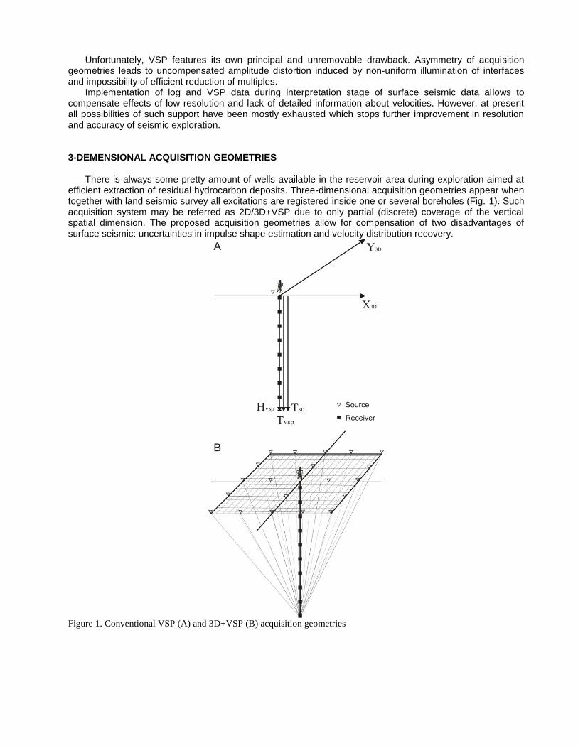
3-DEMENSIONAL ACQUISITION GEOMETRIES
There is always some pretty amount of wells available in the reservoir area during exploration aimed at
efficient extraction of residual hydrocarbon deposits. Three-dimensional acquisition geometries appear when together with land seismic survey all excitations are registered inside one or several boreholes (Fig. 1). Such acquisition system may be referred as 2D/3D+VSP due to only partial (discrete) coverage of the vertical spatial dimension. The proposed acquisition geometries allow for compensation of two disadvantages of surface seismic: uncertainties in impulse shape estimation and velocity distribution recovery.
Figure 1. Conventional VSP (A) and 3D+VSP (B) acquisition geometries
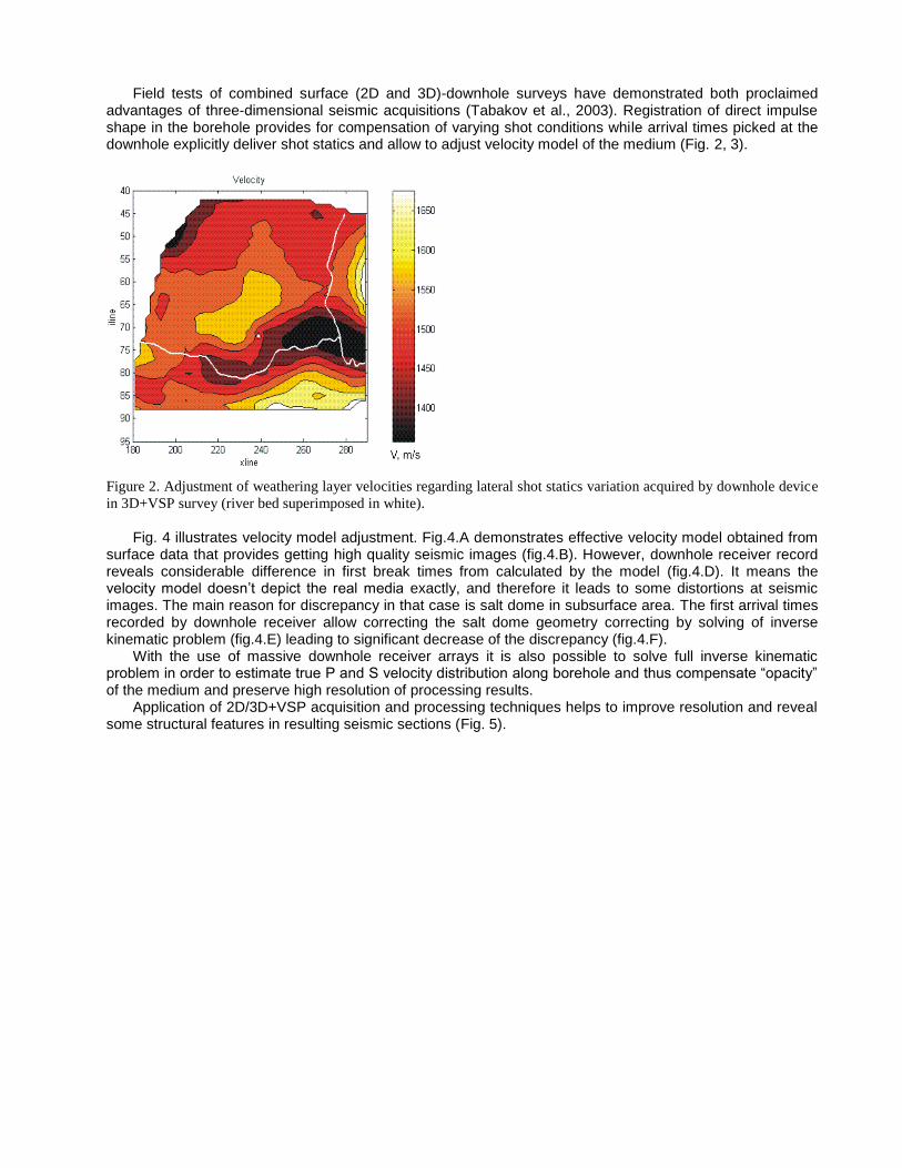
Field tests of combined surface (2D and 3D)-downhole surveys have demonstrated both proclaimed advantages of three-dimensional seismic acquisitions (Tabakov et al., 2003). Registration of direct impulse shape in the borehole provides for compensation of varying shot conditions while arrival times picked at the downhole explicitly deliver shot statics and allow to adjust velocity model of the medium (Fig. 2, 3).
Figure 2. Adjustment of weathering layer velocities regarding lateral shot statics variation acquired by downhole device
in 3D+VSP survey (river bed superimposed in white).
Fig. 4 illustrates velocity model adjustment. Fig.4.A demonstrates effective velocity model obtained from surface data that provides getting high quality seismic images (fig.4.B). However, downhole receiver record reveals considerable difference in first break times from calculated by the model (fig.4.D). It means the velocity model doesn’t depict the real media exactly, and therefore it leads to some distortions at seismic images. The main reason for discrepancy in that case is salt dome in subsurface area. The first arrival times recorded by downhole receiver allow correcting the salt dome geometry correcting by solving of inverse kinematic problem (fig.4.E) leading to significant decrease of the discrepancy (fig.4.F).
With the use of massive downhole receiver arrays it is also possible to solve full inverse kinematic problem in order to estimate true P and S velocity distribution along borehole and thus compensate “opacity” of the medium and preserve high resolution of processing results.
Application of 2D/3D+VSP acquisition and processing techniques helps to improve resolution and reveal some structural features in resulting seismic sections (Fig. 5).
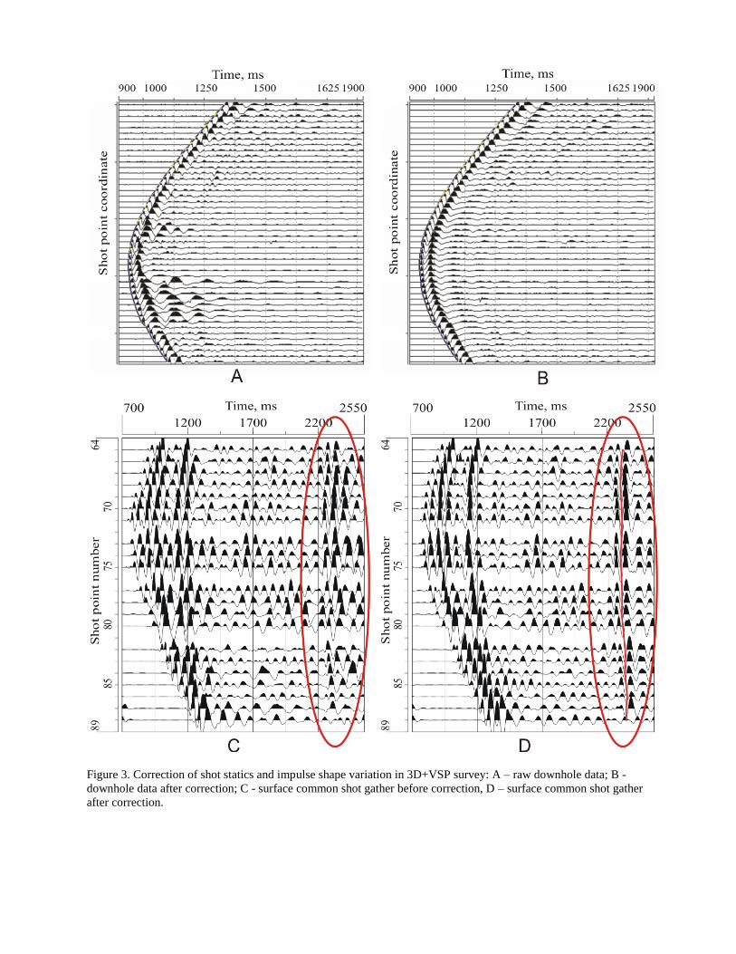
Figure 3. Correction of shot statics and impulse shape variation in 3D+VSP survey: A – raw downhole data; B -
downhole data after correction; C - surface common shot gather before correction, D – surface common shot gather
after correction.
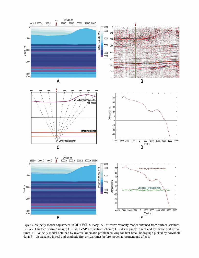
Figure 4. Velocity model adjustment in 3D+VSP survey: A - effective velocity model obtained from surface seismics;
B – a 2D surface seismic image; C – 3D+VSP acquisition scheme; D – discrepancy in real and synthetic first arrival
times; E – velocity model obtained by inverse kinematic problem solving for first break hodograph picked by downhole
data; F – discrepancy in real and synthetic first arrival times before model adjustment and after it.
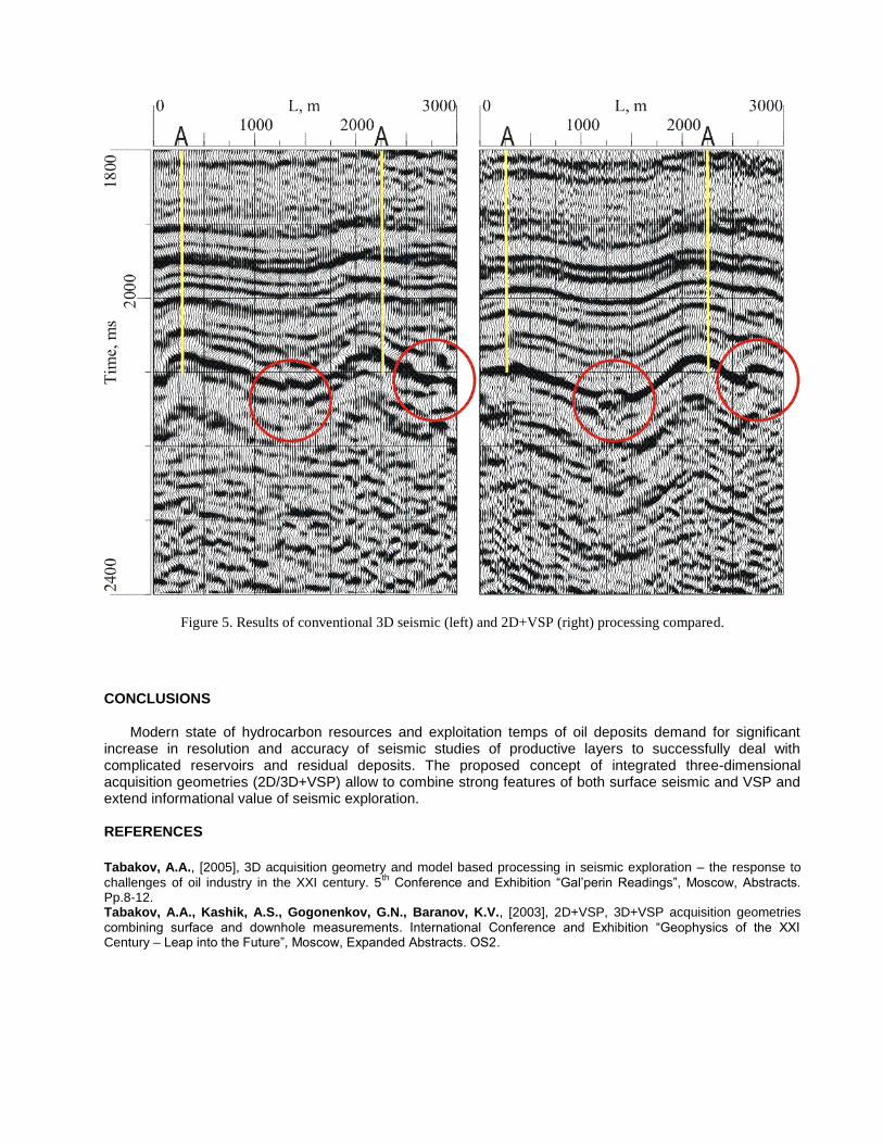
Figure 5. Results of conventional 3D seismic (left) and 2D+VSP (right) processing compared.
CONCLUSIONS
Modern state of hydrocarbon resources and exploitation temps of oil deposits demand for significant increase in resolution and accuracy of seismic studies of productive layers to successfully deal with complicated reservoirs and residual deposits. The proposed concept of integrated three-dimensional acquisition geometries (2D/3D+VSP) allow to combine strong features of both surface seismic and VSP and extend informational value of seismic exploration. REFERENCES
Tabakov, A.A., [2005], 3D acquisition geometry and model based processing in seismic exploration – the response to
challenges of oil industry in the XXI century. 5th
Conference and Exhibition “Gal’perin Readings”, Moscow, Abstracts. Pp.8-12. Tabakov, A.A., Kashik, A.S., Gogonenkov, G.N., Baranov, K.V., [2003], 2D+VSP, 3D+VSP acquisition geometries
combining surface and downhole measurements. International Conference and Exhibition “Geophysics of the XXI Century – Leap into the Future”, Moscow, Expanded Abstracts. OS2.