Embed Size (px)
Citation preview

TS 39 – Land Administration Organisations and the Future Elmar Happ, AED-SICAD Aktiengesellschaft Integrated Land Management Solution For National Cadastre Projects Shaping the Change XXIII FIG Congress Munich, Germany, October 8-13, 2006
1/16
Integrated Land Management Solution For National Cadastre Projects
Elmar HAPP, Germany
Key words: Landmanagement, Cadastre, ALKIS, AFIS, ATKIS SUMMARY The European Union is expanding rapidly and is asking new member states among others to allow free movement of capital goods, which implicitly means a reliable working cadastre system. The Fédération International de Géomètres (FIG) currently develops a data model for a cadastre system, which integrates the “legal” and the “spatial” component, aiming to become an international standard. Such an integrated data model for a new cadastre system is currently being implemented in the German states, known as ALKIS. The advantage of the new concept is that the data model is not only designed for cadastre. It also integrates the spatial reference (AFIS) and the digital landscape models with the corresponding digital topographic maps (ATKIS). The new standard is called “AFIS-ALKIS-ATKIS”, or short “AAA”. In this presentation, we will highlight current requirements to national cadastre projects with a special focus on the current AAA implementation projects in Germany. Besides the above mentioned we will point out crucial issues such as the use of IT-standards, user-friendly workflows for cadastral business processes, efficient data-flow between producers and users of geoinformation as well as history models for cadastral data.

TS 39 – Land Administration Organisations and the Future Elmar Happ, AED-SICAD Aktiengesellschaft Integrated Land Management Solution For National Cadastre Projects Shaping the Change XXIII FIG Congress Munich, Germany, October 8-13, 2006
2/16
Integrated Land Management Solution for National Cadastre Projects
Elmar HAPP, Germany 1. INTRODUCTION Since a number of years, the possibilities for the digital capture and update of spatial and non-spatial information (e.g. personal and stock data) in the field of real estate cadastre and surveying are subject to fundamental changes. The existing organizational and technical environment allows an extensive re-orientation in land information systems in order to realize the existing challenges during the next decades. Based on the AFIS-ALKIS-ATKIS (*) standard of the German Working Committee of the Surveying Authorities (AdV), AED-SICAD offers the new innovative LM on ArcGIS product family for all important tasks in land management, starting with mobile data capture until data distribution via the Internet. The AED-SICAD land information system is marketed in Germany as the “LM on ArcGIS product suite” (based on the AFIS-ALKIS-ATKIS (*) standard) and outside of Germany as “LM on ArcGIS”. The LM on ArcGIS product suite comprises components that are harmonized with respect to content and ease of use and can be combined to a uniform "look and feel". Apart from that, the product family is designed so openly that - based on the German cadastre base model - all GIS related topics of the public and private administration can be embedded as complementary procedures. Through this trendsetting strategy, comprehensive and modern solutions are created, which are being introduced and optimized successfully in countrywide projects in close cooperation with the end-users. Various federal states of Germany already opted for applications of the LM on ArcGIS product suite of AED-SICAD. With the LM on ArcGIS product suite, AED-SICAD consequently expands its portfolio of systems for cadastre and land surveying. The ESRI ArcGIS base technology is the basis for all product development. Specification, development and marketing of the products takes place in close cooperation with ESRI and Leica Geosystems. (*) AFIS = Authoritative Fixed Point Information System ALKIS = Authoritative Real Estate Information System ATKIS = Authorized Topographic/Cartographic Information System 2. SYSTEM OVERVIEW 3A 2.1 Overview The product line contains a number of functionally harmonized applications, which are designed according to the respective task. Based on the development tools and the applications of ESRI’s ArcGIS product family, the LM on ArcGIS product suite contains
TS 39 – Land Administration Organisations and the Future Elmar Happ, AED-SICAD Aktiengesellschaft Integrated Land Management Solution For National Cadastre Projects Shaping the Change XXIII FIG Congress Munich, Germany, October 8-13, 2006
3/16
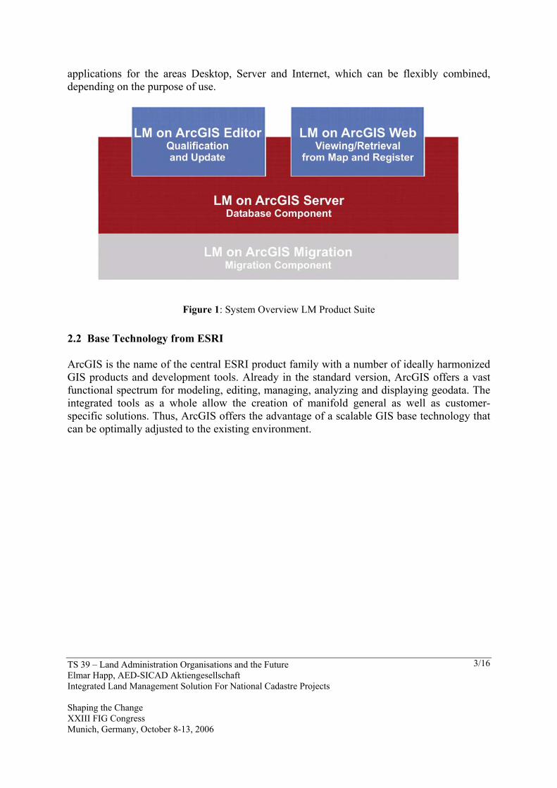
applications for the areas Desktop, Server and Internet, which can be flexibly combined, depending on the purpose of use.
Figure 1: System Overview LM Product Suite 2.2 Base Technology from ESRI ArcGIS is the name of the central ESRI product family with a number of ideally harmonized GIS products and development tools. Already in the standard version, ArcGIS offers a vast functional spectrum for modeling, editing, managing, analyzing and displaying geodata. The integrated tools as a whole allow the creation of manifold general as well as customer-specific solutions. Thus, ArcGIS offers the advantage of a scalable GIS base technology that can be optimally adjusted to the existing environment.
TS 39 – Land Administration Organisations and the Future Elmar Happ, AED-SICAD Aktiengesellschaft Integrated Land Management Solution For National Cadastre Projects Shaping the Change XXIII FIG Congress Munich, Germany, October 8-13, 2006
4/16
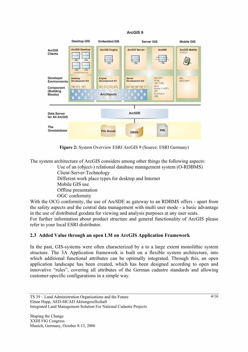
Figure 2: System Overview ESRI ArcGIS 9 (Source: ESRI Germany)
The system architecture of ArcGIS considers among other things the following aspects:
Use of an (object-) relational database management system (O-RDBMS) Client-Server-Technology Different work place types for desktop and Internet Mobile GIS use Offline presentation OGC conformity
With the OCG conformity, the use of ArcSDE as gateway to an RDBMS offers - apart from the safety aspects and the central data management with multi user mode - a basic advantage in the use of distributed geodata for viewing and analysis purposes at any user seats. For further information about product structure and general functionality of ArcGIS please refer to your local ESRI distributor. 2.3 Added Value through an open LM on ArcGIS Application Framework In the past, GIS-systems were often characterized by a to a large extent monolithic system structure. The 3A Application framework is built on a flexible system architecture, into which additional functional attributes can be optimally integrated. Through this, an open application landscape has been created, which has been designed according to open and innovative “rules”, covering all attributes of the German cadastre standards and allowing customer-specific configurations in a simple way.
TS 39 – Land Administration Organisations and the Future Elmar Happ, AED-SICAD Aktiengesellschaft Integrated Land Management Solution For National Cadastre Projects Shaping the Change XXIII FIG Congress Munich, Germany, October 8-13, 2006
5/16
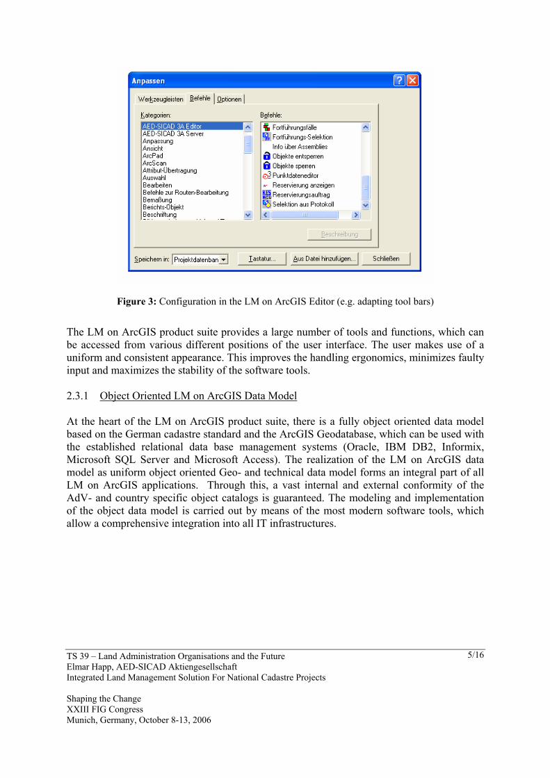
Figure 3: Configuration in the LM on ArcGIS Editor (e.g. adapting tool bars)
The LM on ArcGIS product suite provides a large number of tools and functions, which can be accessed from various different positions of the user interface. The user makes use of a uniform and consistent appearance. This improves the handling ergonomics, minimizes faulty input and maximizes the stability of the software tools. 2.3.1 Object Oriented LM on ArcGIS Data Model At the heart of the LM on ArcGIS product suite, there is a fully object oriented data model based on the German cadastre standard and the ArcGIS Geodatabase, which can be used with the established relational data base management systems (Oracle, IBM DB2, Informix, Microsoft SQL Server and Microsoft Access). The realization of the LM on ArcGIS data model as uniform object oriented Geo- and technical data model forms an integral part of all LM on ArcGIS applications. Through this, a vast internal and external conformity of the AdV- and country specific object catalogs is guaranteed. The modeling and implementation of the object data model is carried out by means of the most modern software tools, which allow a comprehensive integration into all IT infrastructures.

TS 39 – Land Administration Organisations and the Future Elmar Happ, AED-SICAD Aktiengesellschaft Integrated Land Management Solution For National Cadastre Projects Shaping the Change XXIII FIG Congress Munich, Germany, October 8-13, 2006
6/16
Figure 4: Complete online documentation of the LM on ArcGIS object model
Country-specific enhancements as well as customer specific configuration requests can be incorporated consistently and comprehensibly into the application framework of the LM on ArcGIS product suite. Thus, it is warranted, that functions that are built on the model, e.g. to create a country-specific standard extract, can be derived from the uniform LM on ArcGIS data model without the need of additional program specific interventions or enhancements. 2.3.2 Workflow Management (Integrated Project and Order Management) The applications of the LM on ArcGIS product suite dispose of a workflow management with which the user navigates through all update processes of the project and is offered exactly those tools, which he needs to complete the next work step. The work steps and their results become traceable and are thus documented in a proper way for the Real Estate Cadastre. Users have comprehensive possibilities to configure their complex workflows via a business process meta model in a simple and concise way.
TS 39 – Land Administration Organisations and the Future Elmar Happ, AED-SICAD Aktiengesellschaft Integrated Land Management Solution For National Cadastre Projects Shaping the Change XXIII FIG Congress Munich, Germany, October 8-13, 2006
7/16
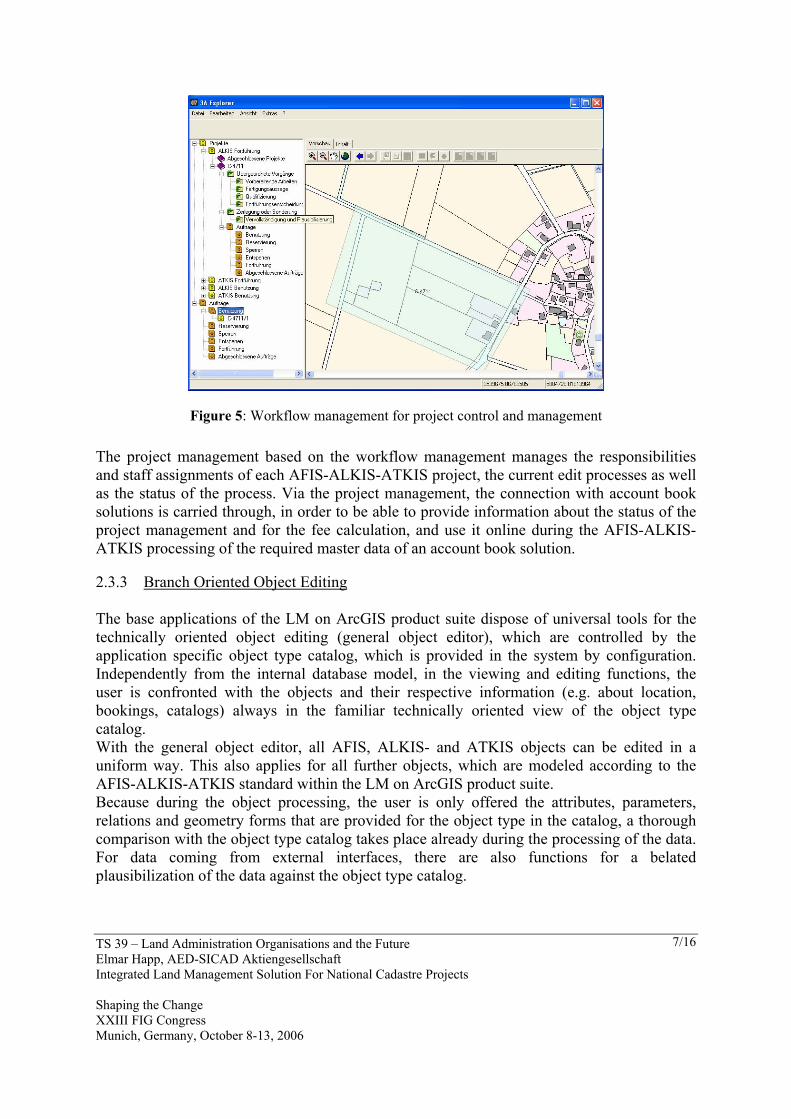
Figure 5: Workflow management for project control and management The project management based on the workflow management manages the responsibilities and staff assignments of each AFIS-ALKIS-ATKIS project, the current edit processes as well as the status of the process. Via the project management, the connection with account book solutions is carried through, in order to be able to provide information about the status of the project management and for the fee calculation, and use it online during the AFIS-ALKIS-ATKIS processing of the required master data of an account book solution. 2.3.3 Branch Oriented Object Editing The base applications of the LM on ArcGIS product suite dispose of universal tools for the technically oriented object editing (general object editor), which are controlled by the application specific object type catalog, which is provided in the system by configuration. Independently from the internal database model, in the viewing and editing functions, the user is confronted with the objects and their respective information (e.g. about location, bookings, catalogs) always in the familiar technically oriented view of the object type catalog. With the general object editor, all AFIS, ALKIS- and ATKIS objects can be edited in a uniform way. This also applies for all further objects, which are modeled according to the AFIS-ALKIS-ATKIS standard within the LM on ArcGIS product suite. Because during the object processing, the user is only offered the attributes, parameters, relations and geometry forms that are provided for the object type in the catalog, a thorough comparison with the object type catalog takes place already during the processing of the data. For data coming from external interfaces, there are also functions for a belated plausibilization of the data against the object type catalog.

TS 39 – Land Administration Organisations and the Future Elmar Happ, AED-SICAD Aktiengesellschaft Integrated Land Management Solution For National Cadastre Projects Shaping the Change XXIII FIG Congress Munich, Germany, October 8-13, 2006
8/16
Figure 6: Branch oriented object editing
The universal and branch oriented editing tools of the base products are complemented in the application-specific components of the 3A product suite by special editing functionalities for AFIS, ALKIS as well as ATKIS–DLM (Digital Landscape Model) and ATKIS-DTK (Digital Topographic Map). 2.3.4 Efficient Access Control and User Administration Already the AdV’s AFIS-ALKIS-ATKIS standard model provides users and user profiles. Basically, these manage the rights related to certain data as well as the configuration of the user related update of the reference data, because they are based on the access level of the so-called NAS (norm based swap interface) and thus on the server. Rights in handling business processes and therefore rights in functionality, as it is required especially for data editing and processing, remain unconsidered. By using the User & Resource Management (URM), AED-SICAD has established a uniform user and authorization management in all its applications, which allows to freely assign rights in specific resources to certain users and different user groups. Resources can be data as well as processes and functionalities.

TS 39 – Land Administration Organisations and the Future Elmar Happ, AED-SICAD Aktiengesellschaft Integrated Land Management Solution For National Cadastre Projects Shaping the Change XXIII FIG Congress Munich, Germany, October 8-13, 2006
9/16
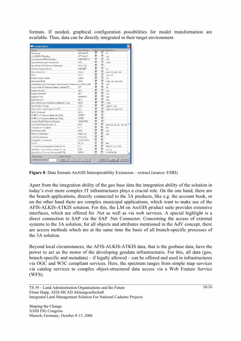
Figure 7: Web based user administration (AED-SICAD User Resource Management) For the different branches, the URM is the basis of all desktop and web applications. Thus, with one single system, the entire administration of the users and rights has been reached, which realizes a uniform management as well as a “Single Sign On“ of the users: once registered in the system, the user profile is stored in all AED-SICAD applications and with it of course also in the LM on ArcGIS products. 2.3.5 Integration Ability Through Open and Documented Interfaces The ability for integration as well as the usability is especially worth for consideration. The key for this central quality aspect of the LM on ArcGIS product suite are the interfaces – by means of them, the geo basis data as well as the system functions are opened to the major context of an authority-wide GIS architecture. Principally, each AFIS-ALKIS-ATKIS solution covers the communication via NAS. Here, all reference data and export products may be exchanged without loss. Through the consequent use of international standards, starting with XML, a significantly higher success is being expected compared to the predecessor EDBS. Nevertheless, the NAS cannot be the only access to the data, because in its completeness but also complexity it is directed to the “demanding” user. For simpler data use – which is by far the majority – already ArcGIS as base technology provides a large number of supported formats, like ASCII, DXF (and with it indirectly DWG), Shape, Coverage, PDF, Enhanced Metafile, EPS, TIFF, JPEG along with other established formats. If this is not enough, the ArcGIS Interoperability Extension, based on the Feature Manipulation Engine (FME) by Safe Software, offers a tool, which is optimally incorporated in the solution environment and supports more than 100 additional
TS 39 – Land Administration Organisations and the Future Elmar Happ, AED-SICAD Aktiengesellschaft Integrated Land Management Solution For National Cadastre Projects Shaping the Change XXIII FIG Congress Munich, Germany, October 8-13, 2006
10/16
formats. If needed, graphical configuration possibilities for model transformation are available. Thus, data can be directly integrated in their target environment.
Figure 8: Data formats ArcGIS Interoperability Extension – extract (source: ESRI) Apart from the integration ability of the geo base data the integration ability of the solution in today’s ever more complex IT infrastructures plays a crucial role. On the one hand, there are the branch applications, directly connected to the 3A products, like e.g. the account book, or on the other hand there are complex municipal applications, which want to make use of the AFIS-ALKIS-ATKIS solution. For this, the LM on ArcGIS product suite provides extensive interfaces, which are offered for .Net as well as via web services. A special highlight is a direct connection to SAP via the SAP .Net Connector. Concerning the access of external systems to the 3A solution, for all objects and attributes mentioned in the AdV concept, there are access methods which are at the same time the basis of all branch-specific processes of the 3A solution. Beyond local circumstances, the AFIS-ALKIS-ATKIS data, that is the geobase data, have the power to act as the motor of the developing geodata infrastructures. For this, all data (geo, branch-specific and metadata) – if legally allowed – can be offered and used in infrastructures via OGC and W3C compliant services. Here, the spectrum ranges from simple map services via catalog services to complex object-structured data access via a Web Feature Service (WFS).

TS 39 – Land Administration Organisations and the Future Elmar Happ, AED-SICAD Aktiengesellschaft Integrated Land Management Solution For National Cadastre Projects Shaping the Change XXIII FIG Congress Munich, Germany, October 8-13, 2006
11/16
2.3.6 Integrated Data Analysis in Map and Register The integrated processing within AFIS-ALKIS-ATKIS of geo and branch specific data, which together describe – among other things - the legal relationships in real estate cadastre, allow for a redundancy free data storage and better use of the data for advanced analysis. The use and analysis can be based on geo-related questions (identification of all owners who are of interest in a concrete geo-related context, provision of this information in a Microsoft Office compliant data format, e.g. for an advanced Excel evaluation), as well as on questions with respect to contents of the Cadastral Register or an owner inquiry (identification and display of all land parcels of a proprietor which are located within the planned construction site).
Figure 9: Space oriented data analysis
Especially in combination with further, e.g. municipal geo and branch-specific data sets, the user gets a convenient tool for nearly all questions related to space oriented information. Already based on the Automated Real Estate Map (ALK) and the Automated Real Estate Book (ALB), a broad spectrum of analyses may be realized, but by introducing AFIS-ALKIS-ATKIS, both the integration ability of the data sets as well as the used tools are improved. 2.3.7 Data Visualization and Plotting The display of the data on the screen as well as a high quality paper output have always set the standard for geodata processing in real estate cadastre and for the creation of topographical maps in land surveying. Point of origin and essential quality feature is the signature catalog compliant presentation of the most different object type catalogs. In order to

TS 39 – Land Administration Organisations and the Future Elmar Happ, AED-SICAD Aktiengesellschaft Integrated Land Management Solution For National Cadastre Projects Shaping the Change XXIII FIG Congress Munich, Germany, October 8-13, 2006
12/16
realize the complex visualization methods, AED-SICAD has created necessary extensions based on the ArcGIS technology, because the GIS base tools – for all their comfort - could not meet the presentation requirements. Now, apart from a signature catalog compliant way of visualization, there are also other possibilities, which are of particular importance for the use and processing of data in analyses and thematic maps.
Figure 10: View of DTK25 (Digital Topographical Map)
To meet the requirements in terms of paper output – especially for large formats – the abilities of ArcGIS in the domain of map layout have been combined with the long-time experience of AED-SICAD in plotting with PLOT. Thus, by using specific tools and libraries, map sheets can be interactively designed in ArcGIS layout mode and then printed via a “plot line”. For this, PLOT is directly integrated in ArcGIS via EPS. Therefore, apart from the high quality vector, raster and hybrid output, also the entire plot management of PLOT is available, which allows to meet highest demands like e.g. for the creation of the Digital Topographical Map (DTK). 2.3.8 Configuration of the Products For a user-oriented configuration of the 3A products, a series of comfortable options on different system levels are available. First aim is that the users – via system settings and customizing tools – can as far as possible influence the data modeling as well as processes and user interface to meet their own requirements. Apart from the exemplified configuration possibilities, there are still a series of detail parameters with which the software can be adapted to the customers’ requirements. Among others these are, e.g.:

TS 39 – Land Administration Organisations and the Future Elmar Happ, AED-SICAD Aktiengesellschaft Integrated Land Management Solution For National Cadastre Projects Shaping the Change XXIII FIG Congress Munich, Germany, October 8-13, 2006
13/16
Use of different geometry types (e.g. splines) Geodetic coordinate system of the database Conversion parameters of different coordinate systems Choice of local project database: ArcGIS personal geodatabase or via ArcSDE
2.3.9 Metadata Metadata, as describing data of data and services, are used for the documentation of own data sets as well as for preparing catalogs for data use and provision. The collection, maintenance and presentation of metadata are realized in accordance with ISO standard 19115 and the specifications in the standard of the German cadastre. With ESRI’s ArcGIS, the LM on ArcGIS product suite has a powerful tool set for capture, administration and publication of metadata. These provide information about the existence of datasets, their content and quality. The metadata administration differentiates between attributes, which are generated automatically of the dataset – e.g. the dimension and structure of the attribute data – and documentation as information entered by the user, e.g. the original dataset, the person responsible for the data etc. The metadata are automatically generated or updated, respectively, when a catalog entry is retrieved for the first time – if metadata already exist. When collecting the data, a powerful assistant supports the user.
Figure 11: ISO Metadata assistant in ESRI ArcCatalog The metadata collected this way can be published and used within a geodata infrastructure (GDI) to find the geobase data and services. The central concept of the LM on ArcGIS product suite is to directly collect and manage AFIS-ALKIS-ATKIS related metadata together with the geo and branch specific data. This helps to guarantee their high quality at

TS 39 – Land Administration Organisations and the Future Elmar Happ, AED-SICAD Aktiengesellschaft Integrated Land Management Solution For National Cadastre Projects Shaping the Change XXIII FIG Congress Munich, Germany, October 8-13, 2006
14/16
any time, because there does not have to be a parallel working process. Likewise, the metadata can be captured and edited in the same tool without system change.
Country Specific Feature Type Catalogs Feature type catalogs can be generated according to the specifications of the different countries during system implementation. Currently, they are generated by means of the Rational Rose Scripts of the AdV (AAA catalog tool und AAA profile tool) and provided in the 3A components via an XML file. From GeoInfoDok 4.0 onwards, there is also a so-called NAS (norm-based exchange interface) for the country specific feature type catalogs. With it, they can be stored in ESRI geodatabases and edited directly via the object editor.
Workflow Management: Configuration of Operating Processes Modeling and local configuration of the different operating processes can be done according to the needs of a country or user. Here, the configuration of business processes is handled by means of a central process control database.
Figure 12: Country specific configuration
User Administration and Access Control The LM on ArcGIS product suite includes a user administration to manage the branch-specific access rights as well as the authorizations for carrying out operating and administration functions. The data model integrates the user administration designed by the AdV which both determines the access rights to AFIS-ALKIS-ATKIS data and also manages the NAS operations which a user or user group, respectively, is allowed to carry out and - if applicable - with which options. For the implementation of users and their rights, the URM (User Resource Management) of the AED-SICAD application framework is used.
External Code Lists (Encryption Tables)
Encryption tables can also be entered in the system country specific. They are imported as XML file (as provided by the AdV or other countries) and then considered e.g. during the plausibilization, with the Object Editor and the business processes.

TS 39 – Land Administration Organisations and the Future Elmar Happ, AED-SICAD Aktiengesellschaft Integrated Land Management Solution For National Cadastre Projects Shaping the Change XXIII FIG Congress Munich, Germany, October 8-13, 2006
15/16
Versioning: Basic or complete history The LM on ArcGIS products can be operated with two kinds of versioning: As standard with the so-called basic history is supported, which is necessary e.g. for the cascading procedure of user related reference data update (NBA). The LM on ArcGIS product suite supports also the management of a complete history. 3. SUMMARY Based on the AFIS-ALKIS-ATKIS standard of the Working committee of the German Surveying Agencies (AdV), AED-SICAD offers a new innovative LM on ArcGIS product suite for all major tasks in land management, starting from mobile data collection to data distribution in the Internet. All LM on ArcGIS applications are designed in close cooperation with users and specified as well as in productive use in a series of countrywide projects. The LM on ArcGIS product suite is an innovative and powerful solution for the collection, management and use of the AFIS-ALKIS-ATKIS data, with a number of technical functions with open and documented interfaces and a flexible application structure. All this is necessary to guarantee that the AFIS-ALKIS-ATKIS based data and services will keep playing their important role in the future.
AFIS-ALKIS-ATKIS as the most important basis for nearly all space-oriented processes! REFERENCES Dokumentation zur Modellierung der Geoinformationen amtlichen Vermessungswesens (GeoInfoDok), Working Committee of the Surveying Authorities of the States of the Federal Republic of Germany, 2006 www.adv-online.de www.aed-sicad.com BIOGRAPHICAL NOTES
Academic title Dipl.-Ing. Geodesy, VermAss Geodesy
Professional experience Since 2003 AED-SICAD Aktiengesellschaft Head of Produktmanagement Landmanagement Since 2000 AED Graphics Aktiengesellschaft Product Manager ALKIS Since 1997 AED Graphics GmbH Head of Quality Management AED Since 1994 AED Graphics GmbH Education and Support "AED-GIS"

TS 39 – Land Administration Organisations and the Future Elmar Happ, AED-SICAD Aktiengesellschaft Integrated Land Management Solution For National Cadastre Projects Shaping the Change XXIII FIG Congress Munich, Germany, October 8-13, 2006
16/16
Education 1992 - 1994 ministry of the interior North Rhine-Westphalia internship Geodesie Qualification: Geodesy Assessor 1984 - 1991 University Bonn Study of Geodesy at Rheinischen Friedrich-Wilhelms-Universität Bonn Qualification: Diplom-Ingenieur Geodesy CONTACTS Dipl.-Ing. Elmar Happ AED-SICAD Aktiengesellschaft Mallwitzstraße 1-3 53177 Bonn Germany Tel. +49 228 9542-0 Fax. +49 228 9542-111 Email: [email protected] Web site: www.aed-sicad.de