Embed Size (px)
Citation preview

Integrated Groundwater Resources Management within
Reverbasins-WorkshopIntegrated Groundwater Resources Management in Sudan
Country paper -Sudan
15th -17th Jan 2019
Nairobi Kenya

Integrated Groundwater Resources Management in Sudan
Contents
• General Description of the country
• Groundwater resources
• Groundwater Development and Utilization
• Institutional and Legal Framework
• Conclusion
Integrated Groundwater Resources Management in Sudan
General Description of the country
Geography
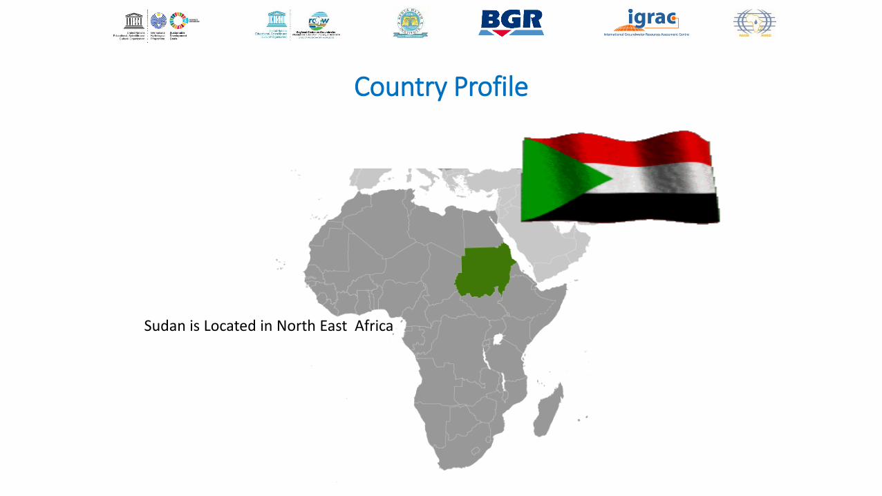
Country Profile
Sudan is Located in North East Africa

Country Profile
Land boundaries:
Central African Republic Chad, Libya , Egypt, Eritrea, Ethiopia, and South Sudan.
Coordinates:
Longitude : 21.75˚to 38˚.5 E
Latitude : 9.2˚to 23˚ N
Terrain:
Generally flat with mountains in east and west.

Country Profile
▪ Country: Republic of Sudan
▪ Federal Capital: Khartoum
▪ States: 18states
▪ Area: 1.85 million sqkm
▪ Population: 41 million
▪ Independence: January 1, 1956.
etatS nrehtroN
etatS aeS deR
etatS rufraD nrehtroN
etatS eliN
etatS nafodroK nrehtroN
etatS rufraD nrehtuoSetatS nafodroK nrehtuoS
etatS feradeG
etatS alassaK
etatS ranneSetatS rufraD nretseW
etatS eliN etihW
etatS eliN eulB
etatS arizeG lE
etatS muotrahK
eliN etihW
kliM
lE-W
eliN niaM
redniD reviR
eliN eulB
libaH ubA.K
madduQ
uM lE
.W
arabtA reviR
alaG lE .WbarA lE rhaB
kliM lE
-W
kliM lE-W
eliN niaM
eliN niaM
kliM
lE-W
alaG lE .W
eliN niaM
eliN
eul
B
38°0'0"E
38°0'0"E
36°0'0"E
36°0'0"E
34°0'0"E
34°0'0"E
32°0'0"E
32°0'0"E
30°0'0"E
30°0'0"E
28°0'0"E
28°0'0"E
26°0'0"E
26°0'0"E
24°0'0"E
24°0'0"E
22°0'0"N
20°0'0"N
18°0'0"N
16°0'0"N
14°0'0"N
12°0'0"N
10°0'0"N
Sudan States
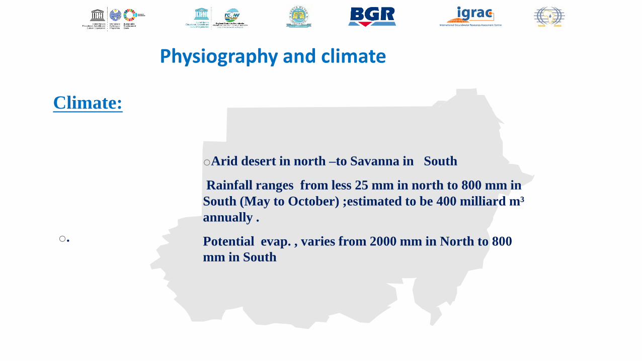
oArid desert in north –to Savanna in South
Rainfall ranges from less 25 mm in north to 800 mm in
South (May to October) ;estimated to be 400 milliard m³
annually .
Potential evap. , varies from 2000 mm in North to 800
mm in South
o.
Climate:
Physiography and climate

Physiography and climate
Topography
• The Nile Valley: an ancient primary drainage system cross cutting the country and flowing north.
• Red Sea scarp: The great erosion scarp that bounds the Red Sea Hills to the east.
• Interior plains: The series of great pediplains, pediments and prominent inselbergs covering thousands of square miles.
• The vast interior depositional plains and basins: Mugld, , Sudd, Blue Nile, Khartoum and Atbara being amongst the largest
• The volcanic uplands of Darfour dome : Jebel Marra , Tagebo Hills, and Meidob Hills.
• The foothills of the Ethiopian volcanic plateau and uplands in the east.

Drainage

Water resources can be classified in four types:-
1. Rainfall.
2. The Nile water resources
3. The seasonal wadis water resources.
3. The Groundwater

1. Rain fall:- Rainfall varies from less than 25mm in
the North to cover 800mm in the extreme south west and south east.
The average annual amount of the rainfall in the country is about 400 milliard m3.
Potential evapotranspiration varies from minimum of 800mm in the south to a maximum 2000 mm in the North.
This exceeds the annual rainfall in most parts of the country.
During the last four decades the total amount of water from rainfall over Sudan was reduced due to aridity, desertification and climate change

2. The Nile water resources:-
The Nile is crossing the country almost from the southern and eastern boundaries.
The Blue Nile and White Nile are the main tributaries.
They meet at Khartoum to form the main Nile.
The Atbra River is one of major tributaries contributing to the Nile North of Khartoum.
Both the Blue Nile and Atbra river and their tributaries originate from the Ethiopian Plateau.
The White Nile Originates from the Central African Plateau.
The Nile and its tributaries are considered one of the main water resources of the country.
eliN etihW
kliM
lE-W
eliN niaM
redniD reviR
eliN eulB
libaH ubA.K
arabtA reviR
alaG lE .WbarA lE rhaB
eliN niaM
eliN
nia
M
eliN eulB
kliM
lE-W
kliM lE-W
eliN niaM
eliN eulB
alaG lE
.W
kliM
lE-W
38°0'0"E
38°0'0"E
36°0'0"E
36°0'0"E
34°0'0"E
34°0'0"E
32°0'0"E
32°0'0"E
30°0'0"E
30°0'0"E
28°0'0"E
28°0'0"E
26°0'0"E
26°0'0"E
24°0'0"E
24°0'0"E
22°0'0"N
20°0'0"N
18°0'0"N
16°0'0"N
14°0'0"N
12°0'0"N
10°0'0"N
River Nile Map Suan
0 150 300 450 60075
Kilometers
. Groundwater & Wadis DirectorateMinistry Of watr Resurces
Abdalla Omer
Legend
metsyS eliN

• Nile water is stored using several dams.
• Water is used for irrigation, domestic supply and for
generating hydro-power.
• Gezira scheme is an example of biggest irrigated scheme
using Nile water stored up stream Sinnar Dam.
• Marawi and Roseires dams are used for generating the
Hydro-electric power.
• Although the annual discharge of the Nile, measured at
Aswan in Egypt is around 84 milliard cubic meters, but the
Sudan’s share is only 18.5 milliard cubic meters , according
to the agreement between Sudan and Egypt.
eliN etihW
kliM
lE-W
eliN niaM
redniD reviR
eliN eulB
libaH ubA.K
arabtA reviR
alaG lE .WbarA lE rhaB
eliN niaM
eliN
nia
M
eliN eulB
kliM
lE-W
kliM lE-W
eliN niaM
eliN eulB
alaG lE
.W
kliM
lE-W
38°0'0"E
38°0'0"E
36°0'0"E
36°0'0"E
34°0'0"E
34°0'0"E
32°0'0"E
32°0'0"E
30°0'0"E
30°0'0"E
28°0'0"E
28°0'0"E
26°0'0"E
26°0'0"E
24°0'0"E
24°0'0"E
22°0'0"N
20°0'0"N
18°0'0"N
16°0'0"N
14°0'0"N
12°0'0"N
10°0'0"N
River Nile Map Suan
0 150 300 450 60075
Kilometers
. Groundwater & Wadis DirectorateMinistry Of watr Resurces
Abdalla Omer
Legend
metsyS eliN

3. The Seasonal wadis water resources
• The runoff after rainy storms contributes to surface water in wadis and Khors cross-cutting the country.
• The seasonal wadis surface water gets its importance mainly due to its wide geographic distribution away from the rivers, as well as its availability in areas where big groundwater aquifers are rare or unavailable, such as area of basement complex.
• Although the rainfall over the entire area of the Sudan exceeds 400 milliard cubic meter the part contributing to stream flow is very limited due to natural conditions such as temperature, soil type, topography, vegetation cover, etc.
• This surface water resources are abundant in southern region south of latitude 12° N , quite significant along savannah belt (latitude 10° - 14° N) and Red Sea Mountains in the north East and quite scarce in areas north of latitude 14° N.

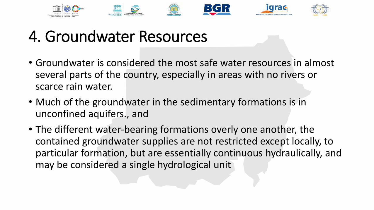
4. Groundwater Resources
• Groundwater is considered the most safe water resources in almost several parts of the country, especially in areas with no rivers or scarce rain water.
• Much of the groundwater in the sedimentary formations is in unconfined aquifers., and
• The different water-bearing formations overly one another, the contained groundwater supplies are not restricted except locally, to particular formation, but are essentially continuous hydraulically, and may be considered a single hydrological unit

G.W. cont.
• Water-bearing saturated zones vary in depth. Depth to stand water may be up to much as 100m below surface.. Usually it is much less (few metwrs-60m).
• In many places hand-dug shallow wells are the source of domestic supplies and livestock water in the dry areas, where surface water supplies are inadequate.
• At few places the water table reaches the surface and oases occur; this especially so in north-western Sudan.

The geology of Sudan, from bottom to top, comprises :-
The Basement complex (BC) – pre-Cambrian to Cambrian in age covering 50% of the country area
Palewzoic
The Nubian formation –Mesozoic-Uncomfortably overlying the undulated B C covering 28% of the country
Tertiary –Umrwaba formation\Volcanic Rocks
Quaternary deposits, Alluvium

Tectonics
Formation of rifts and hence
Groundwater basins resulted
from multi structural
process
.Volcanicity up – doming .
. African plate movement
( Tensional stress )lead
to faulting , subsidence
and linear lift
. Mid plate volcanism lead
to fracturing faulting,
in between is the depositional process.

• The Sudan is fortunate in having considerable groundwater resources.
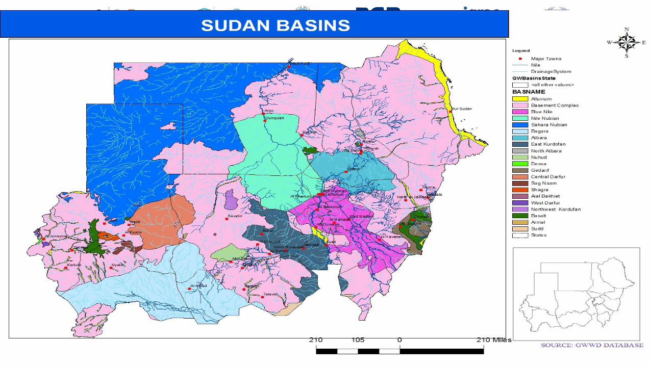
• The resources are distributed over four main groups of basins, namely:
1 Nubian sandstone formation.
2 Umm Ruwaba- Gezira formation .
3 The unconsolidated alluvium.
4 The Basement Complex locally in joints and fractures.
G.W. cont.

Groundwater Systems• The Sudan is fortunate in having considerable groundwater resources.
• 1 Nubian sandstone formation basins.
• 2 Umm Ruwaba- Gezira formation basins.
• 3 The unconsolidated alluvium basins.
• 4 The crystalline Basement Complex and volcanic rocks locally in joints and fractures.

Groundwater Systems 1 Nubian sandstone formation basins
There are about 10 major Nubian basins:-
1. The Sahara Nubian Basin.
2. The Sahara Nile Baisn.
3. The Central Darfur Basin.
4. Nahud Basin.
5. Sag el Na’am Basin
6. River Atbara Basin.
7. Gedaref Basin.
8. Shagara Basin.
9. Bagara Basin.
10. Blue Nile Basin.

1. The Nubian basins group
The Nubian basins are the most important group, composed of the Nubian Sandstone formation.
They constitute the best aquifers where water is found in their arenaceous beds.
They occupy about 28% of the country by surface area.
The last two basins (9, 10) are sometimes referred to Nubian/ Umm Ruwaba basins where both the formations are encountered with the Umm Ruwaba overlying the Nubian and in hydraulic connection with it.
The water levels in these basins range from few meters to about 175 m below ground level. While surface occurrence is found in Seleima, Nikheila and Natron oasis in the northern desert
The group has a high storage capacity .The water quality is good, and seldom exceeds 600 parts per million (ppm) of Total Dissolved Solids (TDS) though higher values are not uncommon.
Recharge to this group, however is minimal and is believed to take place only close to Niles and seasonal streams that flow across the formation, especially over the more southern outcrops where precipitation is heavier

The Nubian basins group The water levels in these basins range from few meters to about 175
m below ground level. While surface occurrence is found in Seleima, Nikheila and Natron oasis in the northern desert
The group has a high storage capacity .
The water quality is good, and seldom exceeds 600 parts per million (ppm) of Total Dissolved Solids (TDS) though higher values are not uncommon.
Recharge to this group, however is minimal and is believed to take place only close to Niles and seasonal streams that flow across the formation, especially over the more southern outcrops where precipitation is heavier
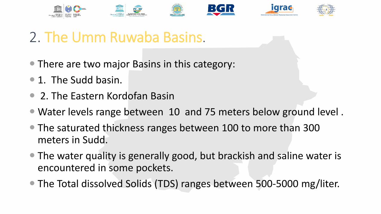
2. The Umm Ruwaba Basins.
There are two major Basins in this category:
1. The Sudd basin.
2. The Eastern Kordofan Basin
Water levels range between 10 and 75 meters below ground level .
The saturated thickness ranges between 100 to more than 300 meters in Sudd.
The water quality is generally good, but brackish and saline water is encountered in some pockets.
The Total dissolved Solids (TDS) ranges between 500-5000 mg/liter.
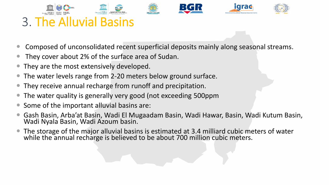
3. The Alluvial Basins
Composed of unconsolidated recent superficial deposits mainly along seasonal streams.
They cover about 2% of the surface area of Sudan.
They are the most extensively developed.
The water levels range from 2-20 meters below ground surface.
They receive annual recharge from runoff and precipitation.
The water quality is generally very good (not exceeding 500ppm
Some of the important alluvial basins are:
Gash Basin, Arba’at Basin, Wadi El Mugaadam Basin, Wadi Hawar, Basin, Wadi Kutum Basin, Wadi Nyala Basin, Wadi Azoum basin.
The storage of the major alluvial basins is estimated at 3.4 milliard cubic meters of water while the annual recharge is believed to be about 700 million cubic meters.

4. The Basement Complex.• The Basement Complex rocks are normally solid and non-water bearing. However in fractured
zones or weathered materials, when recharge is available, local water pocket may exist.
• Water is usually found in the upper parts of the B.C. south of latitude 13°N where rainfall exceeds 300mm/year.
• The weathered zone rarely exceeds the upper 50 meters of the B.C and the depth to water ranges between 20 –30 meters below ground level.
• The water supply from these rocks is mostly very limited and subject to annual recharge and the water quality can be very poor.
• The total storage of B.C Basins is estimated at 2.5 milliard cubic meters and they receive about 1.8 milliard cubic meters as annual recharge.
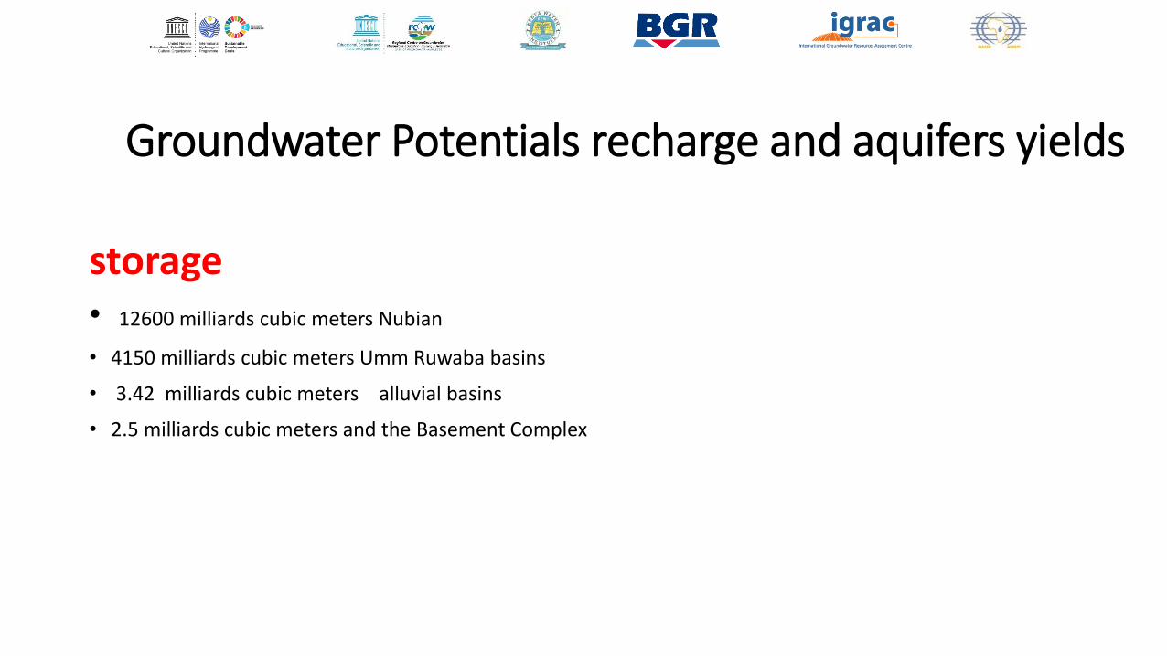
Groundwater Potentials recharge and aquifers yields
storage • 12600 milliards cubic meters Nubian
• 4150 milliards cubic meters Umm Ruwaba basins
• 3.42 milliards cubic meters alluvial basins
• 2.5 milliards cubic meters and the Basement Complex
Groundwater Potentials recharge and aquifers yieldsRecharge• The from direct rainfall at aquifer's formations out crops ,
• rivers flow to aquifers in distance between 13 tom 36 km from rivers
• from seasonal wadi floods.
• The recharge of sedimentary basin in the Nubian d Umm Ruwaba systems is estimated to be around 2 milliad
cubic meters\y.
• Alluvium about 700 million cubic meters\y.
• B.C\volcanics including the alluvium on the BC is 1.8 milliard cubic meters /y
Groundwater Quality• In aquifers in all basins - good to excellent, TDS rarely more than 1000 ppm
• recharge areas at the outcrops or close to the recharging streams the TDS usually less than 250 ppm, and increases in the direction of water flow.
• Lowest concentrations are found in the Nubian group aquifers especially in the pure sandy aquifers, while the highest salinities are found in the Umm Ruwaba aquifers..
• TDS are generally in the range of 200-600 ppm. Values greater than 600 ppm are only found in an areas in the downstream of the basin where it increases with direction of the flow.
• The high TDS values more than 1000ppm and less than 4000ppm rarely found in some zones especially on some clayey aquifers of UmRwaba Formation systems.
• The alluvium aquifers - high variations in TDS and the ionic constitutions where TDS varies from 100 to 2000 ppm

Groundwater development and Utilization:
Importance of Groundwater in Sudan
• Over 50% of the country lies within the desert or semi-arid zones where rainfall and runoff are scarce.
• Scarcity is offset mostly by presence of large groundwater basins.
• Groundwater resources (basins) are fairly distributed and maintain good coverage over the country.
• This may help in formulation and implementation of integrated and well-balanced development projects especially in the rural areas of the country.
• Persistence of drought and erratic rainfall in the country over the last decades has emphasized the importance of groundwater as a reliable source in the rural areas as well as the major urban centers away from the Nile.

• Groundwater can be developed and abstracted by different techniques varying from simple traditional systems (e.g. handdug wells) to relatively complicated mechanical systems such as water yards operated by diesel/electrical driven engines.
• Groundwater can easily be developed and utilized for irrigating small farms manageable by local communities and/or individuals for production of food and with relatively small investment cost, which is compatible with the structure of the rural economy in Sudan.
• Groundwater is less susceptible to environmental changes, less destructive to natural resources and the need for valuable land, which may be used for other productive purposes, is limited.

• Demand for development and utilization of groundwater has mounted up. Groundwater has been recognized and put as part of the overall water resources balance and the long-term water resources plans for economic development.
• No evaporation losses, even when groundwater table is close to the soil surface, the loss due to evapo-transpiration is negligible with respect to the storage capacity of the basin.
Groundwater development and Utilization
Groundwater Abstraction:• historically use -domestic water supplies to people and animals and also to other households needs. Small farms are
traditionally irrigated by groundwater in several parts of the country using large diameter wells in several rural areas in wadis plain and around some rivers e.g Al Gash basin.
• groundwater is widely used in Rural and Urban areas to provide domestic water supply The annual amount of groundwater abstracted by wells for domestic needs in the country is about 900 million cubic meter, account for 32 % of the total abstracted.
• These are pumped from drilled wells or dug wells including hand pumps. Water is even serviced around the well , pumped to elevated tanks(water Yards) or distributed to stand pipes or the houses.
Groundwater Abstraction
• Groundwater is also abstracted for agricultural use to irrigate small farm through drilled wells or dug wells equipped by pumps driven by diesel or electric engines.
• Also now a lot of big investments projects exist in great basins using groundwater to irrigate such big projects by introducing modern irrigation techniques and drilling big wells capable of producing around 300 cubic meters per hour.
• The annual irrigation abstraction exceeds 1850 million cubic meters and accounts to 67% of the total groundwater abstraction.
• The industrial use of groundwater is limited to about 45 million cubic meters which is equal to only 1% of the total annual groundwater abstraction.

Transboundary Waters:
• Sudan shares water resources with some state states, where Nile is Shared with 10 countries (Egypt, Ethiopia, South Sudan, Uganda, Kenya, Tanzania, Burandi, Raunda, D.R. of Gango, Eritrea, and Sudan)
• Seasonal wadis are Shared with, Chad, Eritrea, South Sudan and Central Africa.
• The Groundwater aquifers are shared with 7 countries , where the Nubian sandstone aquifer(Sahara Nubian) is shared with Egypt, Libya, Chad, where a jointed Authority is establish to enable cooperation between the four countries to manage the aquifer.
• The Bagara and Sudd basins are shared between South Sudan and Bagara with Central Africa.
• Desa aquifer is shared between Sudan and Chad. The Gedarif basin is shared with Ethiopia.
• The Gash and Toher alluvium aquifers are shared between Sudan, Eretria and Ethiopia

#
##
##
#
##
#
#
#
#
##
#
#
#
#
#
#
#
#
#
#
#
##
#
#
##
##
#
#
#
#
#
#
#
#
#
#
#
#
#
#
#
SudanChad
Libya Egypt
L A K
E N
A S E
R
Nil e
Riv e
r
Mut
Uzi
Suez
JaluSiw a
Fada
Aswan
Cairo
Baris
Gouro Tekro
Asyut
Derna
Tubruq
Al Kharga
Karim a
Tazerbo
Aw jilah
Dongola
Al Farafra
Rebyana
Bzaymah
ElAtrun
Matrouh
Benghazi
KhartoumOm durman
Ajdabiya
Al Bahareya
Ed Debba
Nukheila
Port Said
Koro Toro
Alexandria
Al Jaghbub
Bini Erdei
Wadi Halfa
Wadi Howar
Bir Misaha
Selim a Oasis
Faya Largeau
Matan Bishara
Laqiya Arbain
Matan As Sarra
Ounianga KebirOunianga Serir
Kufra
Shared NSAS
• Total Area 2199000km2
• Sudan: 17.1%
• Chad: 10.6%
• Egypt: 34.6 %
• Libya: 37.7 %


Institutions and legal Framework
• National water resources policy encourages the assessment, development and the management of the groundwater as a major water resource to be utilized for the secio-economic development of the country.
• The policy addresses issues of wise use, water conservation , trans-boundary aquifers, water pollution, and the groundwater information exchange, the introduction of the integrated approach in water management especially in ground and surface water relations and interactions.
• For ground water utilization and water supply and sanitation strategy and policy are formulated and now ready for endorsement. They addresses issues regarding groundwater utilization for use in drinking purposes.
• The Integrated Water Resources Management(IWRM) policy and strategy are in process and they consider groundwater as major factor for the integrated management.
• To apply the IWRM approach the government with assistance from UNEP, UNICEF, UNESCO-Chair of water, JICA and the academia and research institutes are applying several projects that apply the IWRM approach including some groundwater basins in Darfur, Gash basin, Bara basin and others.
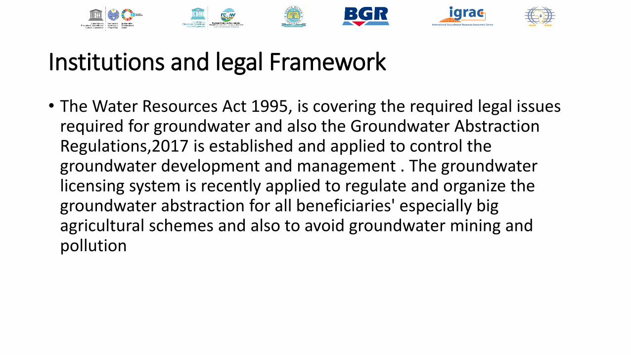
Institutions and legal Framework
• The Water Resources Act 1995, is covering the required legal issues required for groundwater and also the Groundwater Abstraction Regulations,2017 is established and applied to control the groundwater development and management . The groundwater licensing system is recently applied to regulate and organize the groundwater abstraction for all beneficiaries' especially big agricultural schemes and also to avoid groundwater mining and pollution

Institutions and legal Framework
• Institutions responsible and mandated to develop the groundwater are:
• the Ministry of Water Resources , irrigation and Electricity which is responsible for all water resources, irrigation and domestic water supply.
• The Ground Water and Wadis Directorate is responsible for groundwater assessment, development and management, it is satisfactory equipped with instruments for field studies, laboratories, computers and analysis techniques and also with groundwater experts and staff to conduct their responsibilities. State Water Corporations (15) are responsible for rural and urban water supplies in states(drinking water), the use groundwater resources to supply their clients.
• Others include Meteorological Corporation, responsible for rain and climate forecasting
• The private sector is actively participating in the drilling and construction of wells, the storages and the water networks .
• The Universities and the research institutions are considered the main source providing the required knowledge and staff required for the conduction and progress in the groundwater industry. Research and studies and applied research conducted by the Universities and Research institutions are essential for groundwater development in the country.
Stakeholders
Primary Stakeholders
• Community including urban and rural inhabitants, mainly:
• Urban settlements
• Rural settlements
• Farmers
• Pastoralists
• Nomads

Secondary Stakeholders:
1. Domestic water supply Institutions2. Food security institutions 3. Environment and ecosystem4. Meteorological and air forecasting5. Academia (Universities and Research
Institutions)6. Dams and Energy institutions.7. Industry and Mining8. Tourism and wildlife 9. Forestry

Regional and global organizations active in water resources:
• UNICEF, UNESCO\Chair for water UNEP, WMO, IAEA, Nile Basin Imitative ( NBI, UNDP,WB
• FAO, ACSAD,

Conclusion:
Sudan as a big country in area has also a diverse water resources mainly the rain water the Nile , the seasonal streams \ wadis
and a huge potential of groundwater that highly distributed through the country especially in areas with scarce rain and nosurface water.
• The total storage of groundwater in all groundwater systems is estimated to be around 16 trillion cubic meters, mainly paleo –water and also recently recharged water which is estimated to be around 4.5 milliard cubic meters annually.
• The annual abstraction by wells for agricultural, drinking and industrial purposes from the groundwater not exceeding 3milliard cubic meters, leaving a room for considerable amount to be safely abstracted from the renewable groundwater orfrom the storage.
• The country with such potential and limited groundwater recharge is establishing an institutional, legal framework and policesand strategies to wisely develop and manage the potential of good quality groundwater resources to promote and provide thesustainable socio-economic development.