Embed Size (px)
Citation preview

Integrated Coastal Zone Management Training Course
Curriculum, course outline and unit plans incorporating teachers’ notes
April 2013
A project managed by The Nature Conservancy on behalf of AusAid
and implemented by the Australian Tropical Marine Alliance and the Coral Triangle Center
Acknowledgements
Thanks to our Curriculum Development Working Groups many of whom assisted well beyond simply
providing constructive input to the curriculum development. In PNG this included: Barbara Masike,
Augustine Mungkaje, Senita Wauwia, Leah Aisi, Margaret Ame, Aisi Anas, Maxine Anjiga Arua, Leban
Gisawa, John Kakas, John Kasu, Jeff Kinch, Paul Lokani, Demi Markus, Russell Purai, Vagi Rei, Bernard
Suriman, Steven Tandale, Jane Wia. In the Solomon Islands this included: Seno Mauli, Delvine
Boso, Patrick Daudau, Peter Kenilorea, Duta Kauhiona, Alex Makini, Rosalie Masu, Ben Salepo,
Shannon Seeto, John Usuamo, Agnetha Vavekaramui and Jennifer Wate.
We acknowledge Julian Clifton for the bulk of the development and delivery of the ICZM training
materials and Sabine Carter for design work on those materials. Leanne Fernandes for coordination
of all of the above.
This curriculum and supporting teaching materials was developed as part of an Australian
Government-funded project called “Strengthening in-country tropical marine resources
management training capacity in PNG and the SI”. It focuses on training and education priorities for
the Solomon Islands and Papua New Guinea relating to tropical marine resource management. The
project has been managed by The Nature Conservancy (special thanks to Laura Whitford) as part of
the Australian Government’s support to the Coral Triangle Initiative on Coral Reefs, Fisheries and
Food Security and is being implemented by the Coral Triangle Center (with special thanks to Rili
Djohani) and by the Australian Tropical Marine Alliance (James Cook University, University of
Western Australia, University of Queensland, Charles Darwin University and the Australian Institute
of Marine Science). Thanks to the Coral Triangle Support Partnership for some extra funding to
support workshop logistics.
CONTENTS
TRAIN THE TRAINERS .............................................................................................................................. 1
Background ......................................................................................................................................... 1
Tailoring the curriculum to PNG and Solomon Islands ....................................................................... 1
Development of training materials ..................................................................................................... 1
Training-of-trainers methods .............................................................................................................. 2
CURRICULUM .......................................................................................................................................... 2
Overview of course units .................................................................................................................... 5
Learning outcomes .............................................................................................................................. 5
Pedagogy ............................................................................................................................................. 5
Overview of assessment ..................................................................................................................... 6
Flexible training framework ................................................................................................................ 7
Teaching resources ............................................................................................................................. 7
UNIT PLANS INCORPORATING TEACHERS NOTES ................................................................................... 8
Unit 1 Governing Coastal Ecosystems ................................................................................................. 8
Unit 2 Coastal Vulnerability .............................................................................................................. 11
Unit 3 Understanding ICZM .............................................................................................................. 15
Unit 4 Stakeholder Analysis .............................................................................................................. 19
Unit 5 Problem Analysis .................................................................................................................... 22
Unit 6 Objective Analysis .................................................................................................................. 25
Unit 7 Integrated Coastal Planning ................................................................................................... 28
INTEGRATED COASTAL ZONE MANAGEMENT PLAN TEMPLATE........................................................... 32
GLOSSARY OF TERMS ............................................................................................................................ 34
1
TRAIN THE TRAINERS
Background Developing local capacity in tropical marine resource management in support of the Coral Triangle Initiative (CTI) strategies has been among the highest priorities identified by Papua New Guinea and the Solomon Islands.
Government to government liaison identified that there is inadequate marine resource management education curricula and training in government and academic institutions in these countries. As indicated in the regional CTI Plan of Action, Solomon Islands National CTI Plan of Action and PNG’s Marine Plan, marine resource management practitioners often lack access to key/important training, resources or guidance.
Based upon in-country consultations with the Australian Government, a project was developed to address these gaps in PNG and the Solomon Islands. The team comprises: the Australian Tropical Marine Alliance, the Coral Triangle Center and the Nature Conservancy, with support from the Australian Government.
There are three components to the project. Firstly, the curricula intended to build the skills and capacity of marine resource managers will be developed. These curricula are designed to be delivered as short courses (1 week in duration) which will ensure that people currently working as marine resource managers are not precluded from participating due to a busy work schedule. Secondly, existing trainers working in local institutions (local universities for example) will be provided with training in the delivery of the curricula. Thirdly, these trainers will be supervised and mentored as they deliver the training in situ, to a student audience comprising marine resource managers. This package constitutes part of this agreement through delivering a training course in integrated coastal zone management.
Tailoring the curriculum to PNG and Solomon Islands The curriculum has been tailored through: use of local examples, use of locally relevant source materials and prescribed reading for students, ensuring that the teacher and students apply local language and concepts where relevant and possible throughout the curriculum, and application of ideas and advice from in-country expert collaborators garnered both during the scoping study and continued communications.
Development of training materials This training material has been developed by working with in-country curriculum development working groups which include members from both countries’ Departments of Environment, Fisheries and Education as well as various local and international NGOs.
Communications about this curriculum occurred per email, telephone/skype calls and per face-to-face meetings with experts in PNG and Solomon Islands, as well as experts from Australian Institutions including the School of Marine and Tropical Science, the Australian Research Council Centre of Excellence for Coral Reef Studies and the Centre for Sustainable Tropical Fisheries and Aquaculture both at James Cook University.
2
Training-of-trainers methods Training of trainers in PNG and Solomon Islands will occur in-country, with both in-country and international experts working in collaboration.
The trainers will be trained by:
1. Reviewing the entire substance of the curriculum and upskilling trainers’ knowledge base as necessary
2. Role-modelling of proposed class activities to both ensure trainers understand how to implement the activity and to ensure feasibility of activity
3. Reviewing of all teacher and student resource materials to ensure full understanding of their function in student learning and/or extension
4. Unit-per-unit in-training evaluation of trainers comprehension of key learning outcomes which students will need to achieve
Trainers being trained will be asked to keep a “teacher journal” and to enable them to make notes about the training-of-trainers as they are given the material to use and to provide feedback to each other.
CURRICULUM
Title: Integrated Coastal Zone Management (ICZM)
Semester: 4 day intensive short course OR semester-long course
Coordinator: One for each training institution where course to be implemented
Course Rationale
Coastal resources are of fundamental importance in economic, cultural and environmental terms in both PNG and the Solomon Islands. Managing the coastal impacts of human activities including onshore development, forestry, mining, agriculture and the longer term consequences of climate change are essential for development to be sustainable. Integrated coastal zone management (ICZM) is internationally recognised as the optimal means to resolve conflicts associated with coastal environments, to ensure that a wide range of stakeholders can continue to use coastal resources and to facilitate resilience to the impacts of climate change on both coastal communities and environments.
Course Description
This course will teach students about the need for ICZM and how to implement this ICZM. This will involve training in and application of skills in reconciling conflicting demands arising from different stakeholder groups and their needs and demands in the coastal zone.
Curriculum Objectives
3
Students will gain an understanding of:
The unique management demands of the coastal zone as the interface between land and sea
The vulnerability of the coastal zone to human activities
Principles and techniques used to identify conflicting needs associated with the coast
The complex linkages between cause and effect when dealing with coastal problems
Methods to identify priority action areas to address coastal problems
Course Content
1. Understanding the coastal setting: coastal ecosystems and services provided by coastal environments.
2. Coastal planning – government institutions responsible for coastal issues. Understanding the reasons for overlapping and multiple areas of responsibility.
3. Recognising the vulnerability of coastal environments. Identifying direct and indirect threats associated with human activity.
4. Linking threats to services – identifying user groups at most risk in coastal environments.
5. Overview of integration – understanding the importance of horizontal and vertical integration in coastal management.
6. Demonstrating the importance of integration: using examples (mining, oil palm plantations) to show the links between observed coastal problems and underlying driving issues.
7. Understanding the importance of public participation in ICZM – realising the benefits for management.
8. The need to recognise the variety of stakeholder groups and the importance of understanding different priorities amongst stakeholder groups. Examples to be used from mining and oil palm.
9. Using measures of importance and influence to organise stakeholders and facilitate their participation in ICZM.
10. Using problem trees to facilitate understanding of cause-effect pathways and the extent to which they may differ according to individual stakeholder groups. Examples relating catchment activities to coastal environments.
11. Understanding how problem trees can be used to produce objective trees for use by managers. The importance of incorporating stakeholder analysis into implementation plans.
12. Comparing objectives to demonstrate differing stakeholder priorities and values. Understanding the importance of attempting to reach a consensus regarding objectives to form the basis of ICZM.
4
13. Recognising how to deal with conflicting priorities in designing ICZM plans based on stakeholder analysis, problem trees and integrated objective trees.
14. Drawing up a prioritised list of actions. Recognising the need to monitor ICZM activities and follow adaptive management strategies.
Monitoring student learning
Student learning will monitored throughout the teaching and learning process to determine student progress and learning needs. During each unit plan opportunities have been embedded to gather feedback about how students are progressing and what they need to learn next. Specific monitoring opportunities may include:
Student Consultation
Student Reflection including via use of the glossary and class activities
Journal Responses
In addition, formal assessment will be conducted via:
Class practicals/activities (may include assignments and other assessment pieces)
Class tutorial (may include questionnaires and other assessment pieces)
Final assessment: - a draft plan for integrated coastal zone management
Pre-requisites
Knowledge of local coastal environments and the human activities in them.
General reading
European Commission (2001). EU Focus on Coastal Zones. European Commission, Brussels. 36p. Suitable background reading for trainers.
European Commission (2011). OurCoast: Guidance based on selected ICZM cases. European Commission, Brussels. 55p. Suitable background reading for trainers.
South Pacific Regional Environmental Programme (1999). Coastal Management Profiles. SPREP Samoa 213p. Suitable background reading for trainers.
Post RC, Lundin CG eds. (1996). Guidelines for Integrated Coastal Zone Management. Environmentally Sustainable Development Studies and Monographs Series No. 9. The World Bank, Washington DC. 28p. Suitable background reading for students.
Le Tissier M, Roth D, Bavinck M, Visser L. (2011). Integrated Coastal Management: from post-graduate to professional coastal manager. Eburon, Delft. 205p. ISBN 978-90-5972-327-6 .Suitable background reading for trainers.
Worldwide Fund for Nature (2006). Bismarck Solomon Seas Ecoregion: Solomon Islands fisheries, marine and coastal legislation and policy gap analysis. Worldwide Fund for Nature 68p. Suitable background reading for trainers.
5
Overview of course units The course begins of an introduction to be led by the trainer, which may include a local field visit if possible. This is followed by seven taught units which are detailed in this booklet. Teachers’ notes are presented to assist in delivery of each unit, along with references to Powerpoint presentations provided for each unit. The booklet also includes a glossary of terms.
Group introductions Day 1 morning 1 hour
Governing coastal ecosystems Day 1 morning 2.5 hours
Coastal vulnerability Day 1 afternoon 2 hours
Understanding ICZM Day 2 morning 3 hours
Stakeholder analysis Day 2 afternoon 3 hours
Problem analysis Day 3 morning 3 hours
Objective analysis Day 3 afternoon 3 hours
Integrated coastal planning Day 4 6 hours
Conclusions and feedback Day 4 afternoon 0.5 hours
TOTAL 24 hours
Learning outcomes Upon completion of the unit, students will be able to
Encourage institutions and individuals to work in an integrated manner
Identify and prioritise threats to coastal resources associated with human activities
Develop a sustainable strategy to address coastal issues which reflects stakeholders’ views
Communicate and facilitate the need to work in a co-ordinated and integrated manner to address coastal issues
Pedagogy There are four main elements that make up pedagogical approaches and practices: the teacher, the teaching, the place and the curriculum. The specific pedagogical approaches and practices used in developing each of these elements of the teaching materials being prepared are discussed below.
Teacher: This curriculum is designed to be tailored and used by a trainer, lecturer or teacher who has experience delivering learning to mainly adult students. It can also be used to inform and guide workplace mentoring and supervision in ecosystem approaches to fisheries management.
The curriculum developed allows the teacher to bring their own knowledge and experience into the learning environment and to improvise by tailoring the training to the students and situation.
Teaching: The teaching is designed to be student-centred with each unit beginning with an activity which both engages the students and allows the teacher/lecturer to assess the level of knowledge of students in the unit being taught. The teacher can then build on the existing levels of knowledge in
6
the classroom, skip lesson material which is already known and focus on the new learning outcomes of the unit. The teacher can also partner more knowledgeable students with less experienced students in the many teaching activities throughout each unit. Teachers are also encouraged to engage students to help them tailor the course to their individual needs.
The teaching is designed to empower the learner, for example, the presumption that each student can and will deliver an ecosystem-based fisheries management plan by the end of the course.
Place: The training is designed to be and will be delivered in-country and engages with local knowledge and local management practices and uses local case studies all to ensure learning is relevant to the students. The presumption throughout the training is of a partnership with local resource users and community members (although the explicit training for community-based resource management is addressed in another curriculum being developed by this project). The training also addresses the place-specific governance context within which an ecosystem approach to fisheries management must work.
Curriculum: In addition, the curriculum is at least 50% activity based to support learning-by-doing; the curriculum fosters and experiential learning process. This helps to connect the learning to the students work and/or life to make it relevant and interesting. This also supports the development of generic workplace skills, for example, teamwork, critical analysis, presentation skills, planning, communication, problem solving, professional writing skills, interpersonal skills and time management.
Whist high quality hard copies of all the teaching material will be made available, the curriculum developers are aware that, over time, these may be used up, damaged by wear and tear or lost. We have assumed that, in some cases, teachers will only have access to a computer and a black and white printer and the teaching resources have been designed to be usable without access to more than the CD upon which all the teaching materials will be placed. Once the hardcopies are printed, the teacher can take them to places without electricity, without white or blackboards and they shall still be able to deliver the learning outcomes.
The curriculum has been developed with a view to opening pathways so that parts or all of the curriculum is accredited within the formal education systems of PNG and the Solomon Islands.
Overview of assessment The main assessment artefact is a draft plan for integrated coastal zone management. This is designed to be prepared by groups of 4-5 trainees in order to achieve the learning outcomes, as well as stimulate knowledge exchange. If this assessment is formalised, the plan could amount to 50% of total assessment.
Each student will maintain an assessable journal (“diary”) of thoughts, learnings, ideas, etc. which should be used to demonstrate the level and type of engagement each student is having with the coursework and to also help the teacher revise the level and focus of the training to best accommodate student needs. This assessment should comprise 20% of the total.
Each student will maintain a personal glossary of new terms (with local language equivalents) in the back of their diary. This is assessable and worth 10% of the total. Reference can be made to the glossary of terms included in this booklet.
7
The remaining 20% of the assessment can take the form of class practicals/activities or class tutorials. There are very many of these throughout the unit plans as well as suggested review questions. We recommend that each teacher chooses which activities and/or tutorials to use for assessment depending upon the class composition.
Flexible training framework The course has been designed to be delivered in a flexible manner in order to facilitate delivery to trainees of differing backgrounds and skill sets.
University lecturers may choose to deliver the entire course as outlined. This is suitable for final year undergraduate students or those enrolled at postgraduate level.
College educators may choose to deliver a majority of the material to support related courses in coastal management.
Community educators and outreach officers may choose to focus upon the group work components to develop experience and skills amongst resource users with respect to certain issues within coastal zone management.
High School teachers and other responsible for teaching resource management may choose to supplement or enhance current curriculum with examples and ideas drawn from this curriculum.
Teaching resources The teaching resources provided by this project will be provided both in hard copy and on a CD from which additional hardcopies can be printed.
The teaching resources include:
Curriculum
Unit plans (including learning outcome, detailed topics to be covered with suggested timings, classroom activities to reinforce learnings, reflection and review tools)
Unit plans as above including notes for teachers
Glossary of terms
Powerpoint presentation of lessons
References of relevance to students and trainers sorted by unit
General references pertaining to ICZM in both PNG and the Solomon Islands
8
UNIT PLANS INCORPORATING TEACHERS NOTES
Unit 1 Governing Coastal Ecosystems Topic: How is the coastal zone governed?
Learning Outcome: Students will be able understand the functions and services provided by coastal resource and how these are governed
Unit plan
Step Duration
1. Ask class what they understand by the term ‘coastal ecosystems’.
10 min
This is intended to explore trainees’ knowledge of basic ecosystems. Use results to identify the three principal ecosystems: reefs, mangroves and seagrass beds. Other ecosystems that may be mentioned include algal beds, beaches, reef flats etc. However, it is useful to refer to the above three categories as these are spatially distinct yet can be impacted by the same human activities, which is important from the viewpoint of integrated coastal zone management.
2. Work through each of these three, discussing the functions of each ecosystem.
20 min
Use examples here to demonstrate that reefs, mangroves and seagrass beds are linked due to food webs, fish lifecycles and reproductive behaviour. Try to get examples from class: which species are they aware of that move from reef to seagrass bed or from reef to mangrove? If necessary, discuss importance of mangrove as a nursery habitat to convey the idea that different habitats are linked. Use Slide 3 in powerpoint presentation to help explain this section. This topic is dealt with in detail in Unit 4 of Ecosystem Approach to Fisheries Management course, where more references are provided if needed.
3. Describe goods provided by coastal ecosystems and describe the difference between renewable and non-renewable goods
20 min
‘Goods’ here refers to physical items and services derived from use of the marine environment. The term may be difficult to convey, so consider alternatives such as ‘resources’ or ‘products’ and give an example to start trainees thinking.
4. Ask class to categorise these goods into renewable and non-renewable categories
10 min
Confirm difference relating to human exploitation rate and natural renewal capacity is understood
SHORT BREAK 5 min
5. Define coastal services and list those arising from reefs, mangroves and seagrass meadows.
20 min
The aim here is to underline the importance of some key habitats for humans. Coastal services are those which benefit human populations and maintain ecosystem stability. Trainees should understand that some habitats are under more pressure than others because they provide so many services to human populations. Use Slide 4 in powerpoint presentation to help explain this section. Slide 5 shows how many of the services are of direct importance to local users. Highlight the
9
importance of these to local user groups in particular. Use this to remind the class that local users often experience negative impacts of poor coastal management first.
6. Ask class who they think has overall responsibility for coastal government. List government departments mentioned.
10 min
Trainees will likely mention non-government groups, private sector and local user communities as well. However, the focus at this stage is on understanding that government itself is subject to intense conflict regarding coastal management, so ask class to consider government departments only. Identifying user groups and stakeholder participation are introduced in Unit 4 of this course.
7. Use information from step 6 to underline how differing interest groups are involved in coastal government. Taking example of two government departments (for example, forestry and conservation), demonstrate the likelihood of conflicting priorities within government.
20 min
Forestry and conservation are most commonly associated with conflict for obvious reasons. Mention that whilst forestry is a land-based activity, deforestation has marine impacts and therefore conflicts with marine conservation policies. Also discuss with the class the fact that government forestry departments are usually very powerful within governments and can influence overall government policy to favour their interests over those of other departments, including conservation, tourism etc.
8. Show how the coast is under jurisdiction of different levels of government. Underline importance of Exclusive Economic Zone.
15 min
Use Slide 6 to help explain this section. Be clear that some areas of the coast, particularly inshore, can be managed by more than one level of government and that this has many implications for resource management. Highlight that using resources in EEZ is essential for national economic development, not just regional or local livelihoods.
9. Ask class to discuss how involvement of different levels of government is likely to affect conflict. Is conflict more likely or not? Explore reasons why and list these.
15 min
Causes of conflict within government may include - overlapping areas of jurisdiction (mentioned in step 8) - differing priorities regarding resource use, access and management - individual conflicts between staff and ministers within government - political conflicts between government parties
The main point here is to underline that where more than one government body is responsible, each is likely to develop its own policies without consulting the other. This makes conflicting policies more likely which in turn leads to poor resource management and a lack of action.
10. Conclusion. 10 min Highlight importance of coastal ecosystems to human populations and need to manage conflict effectively – this being the basis of integrated coastal zone management.
Total duration = 2hr 30 mins
10
Teaching materials
For teacher: Integrated coastal zone management curriculum CD; computer with printer to print off lesson materials; Blackboard, whiteboard and/or butcher paper and chalk/pens to use with them.
For student: 2 notebooks/exercise books (one to use in classroom for notes; one for journal); pens/pencils etc
Homework: Students to use one of the notebooks/exercise books to record a list of goods and services derived from coastal environments.
Assessment:
Student journal/diary
Student glossary
Teacher to select from the suggestions below: a) Identify which government departments are involved in coastal management b) Give three reasons why the involvement of many government departments leads to
problems in coastal management
Reading material
Cinner JE (2009). Migration and coastal resource use in Papua New Guinea. Ocean and Coastal Management 52, 411-416. Contains a good overview of coastal management issues in PNG. Recommended for both teachers and trainees.
Coral Triangle Initiative (2012). State of the Coral Triangle Report: Papua New Guinea. Contains brief and useful facts and figures relating to coral reef resources. Recommended for both teachers and trainees.
Govan H (2011). Good coastal management practices in the Pacific: experiences from the field. SPREP, Samoa 42p. Contains a brief summary of coastal management challenges and a case study from PNG. Recommended for both teachers and trainees.
Hyndman D (1993). Sea tenure and the management of living marine resources in Papua New Guinea. Pacific Studies 16, 99-114.
11
Unit 2 Coastal Vulnerability Topic: What is coastal vulnerability?
Learning Outcome: Students will be able to identify pressures on the coast and how these relate
to vulnerability of coastal resources and ecosystems
Unit plan
Step Duration
1 Assess prior knowledge through class brainstorm, asking students to identify what human activities take place near the coast
15 min
A list of possible activities is provided in Slide 3. You can ask the class to give you their ideas and then compare this with those provided in the presentation and comment on any differences.
2 Using display materials, tabulate these activities with reference to their environmental impact. Use criteria including short term impacts, long term impacts, localised impacts, large scale impacts. Discuss this with class.
20 min
Use Slide 4 for this stage. The slide identifies the environmental impact of each activity using these criteria. Remind the class that these are very subjective and perceptions of timescale and spatial scale of impact will vary for each individual. Talk specifically about ‘duration’: most activities have short term (eg construction phase) impacts and long term (eg operational or accidental) impacts. Level of certainty reflects amount of activity: newer activities eg wind & wave energy generally have less certain impacts.
3 Ask class to identify which activity they consider to have most environmental impact. Discuss differences in opinion and place in wider international context: to what extent are these reflected in other countries?
15 min
The intention here is to get the class thinking in more detail about how environmental impact is measured. Should it be short term very damaging localised impacts or longer term widespread more persistent impacts? An oil spill is a good example of these differing impacts. Perception of impact is important – ie what can be visually seen as an impact, whilst less obvious (underwater, or out of sight) impacts may be seen as less important. International context allows comparison. One point to make here is that more developed countries face different combinations of threats: more commonly involving pollution, agriculture, urbanisation and fisheries: less so from mining and offshore oil and gas.
4 Discuss difference between direct impacts and indirect impacts. 15 min Slides 5 and 6 in the powerpoint presentation can be used to illustrate this discussion. Direct impacts are those which have a quick and evident effect on marine flora and fauna and are more often associated with lethal impacts. Indirect impacts are those which will occur over longer term, over longer distances and may appear unrelated to the initial activity. Example here is disruption of food webs which have impacts on a wider number of species. This is also covered in Units 4 and 5 of the Ecosystem Approach to Fisheries Management course. Developed countries more often face land-based sources of impact, whereas developing countries more likely to have a combination of land and sea-based impacts – making management all the
12
more complex and expensive.
5 Summarise steps 1-4. 10 min Students should be aware that coastal ecosystems are subject to a variety of interacting pressures, reflecting activities both near and far from the coast itself
SHORT BREAK 5 min
6. Ask class to list words they associate with ‘vulnerability’ 5 min
7. Use feedback and powerpoint material to define and discuss coastal vulnerability.
10 min
Use Slide 7 in the powerpoint presentation here. Work through the concepts
- Exposure: proximity to human activity (or combination of activities) - Sensitivity: ability of human activities to affect coastal environments - Potential impact: reflects combination of exposure and sensitivity - Adaptive capacity: ability of resources to absorb impacts without adverse effect - Vulnerability: balance between potential impact and adaptive capacity
8. Explore concept of ‘sensitivity’ with reference to components of coastal ecosystems discussed in Unit 1.
15 min
Make specific reference to reefs, mangroves and seagrass meadows in terms of contrasting sensitivity. Slide 8 helps identify what influences sensitivity of a particular coastal ecosystem. Use this to discuss what makes reefs particularly sensitive.
9. Ask class to write down what actions can be taken to reduce vulnerability of a coral reef to human impacts in the coastal zone
10 min
Fisheries are dealt with in the Ecosystem Approach to Fisheries Management course, hence the idea here is to encourage consideration of impacts beyond fisheries. Slide 9 will help here. Coral reefs are subject to many threats, a large number of which are directed towards the reef itself rather than its associated fisheries. Measures to reduce reef vulnerability could therefore focus on managing or restricting
- Destructive fishing - Coral mining - Cyanide fishing
- all of which are localised threats to the reef Larger scale threats include
- Onshore mining - Agricultural runoff - Tourism - Climate change
- all of which require different management approaches.
10. Use these actions to highlight that class has just outlined strategies for coastal management. Undertake brief analysis, focusing on those which address localised threats to coral reefs
15 min
Slides 10 and 11 will be useful here. The intention is to raise a direct link between threat and possible management response.
11. Conclusion. 10 min
13
Highlight to class that human activities have individual and cumulative impacts and that different coastal ecosystems will cope with these to differing extents
Total duration = 2 hr 15 mins
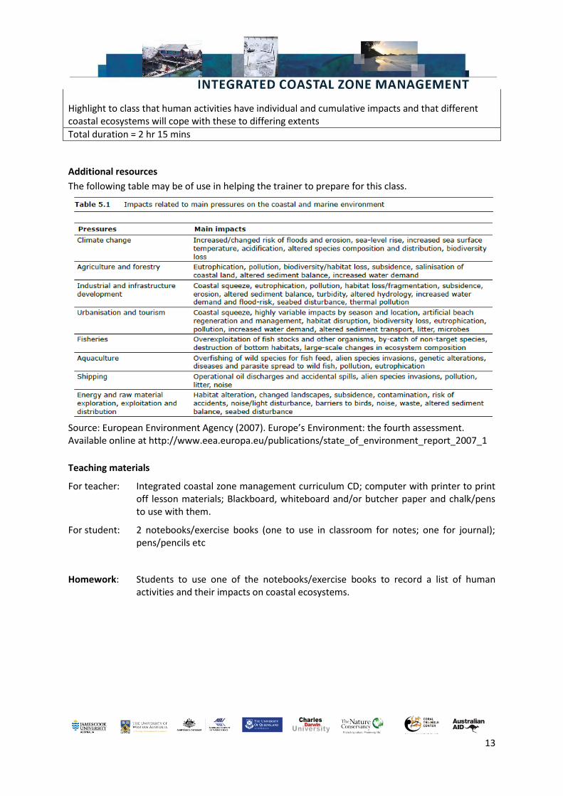
Additional resources
The following table may be of use in helping the trainer to prepare for this class.
Source: European Environment Agency (2007). Europe’s Environment: the fourth assessment. Available online at http://www.eea.europa.eu/publications/state_of_environment_report_2007_1
Teaching materials
For teacher: Integrated coastal zone management curriculum CD; computer with printer to print off lesson materials; Blackboard, whiteboard and/or butcher paper and chalk/pens to use with them.
For student: 2 notebooks/exercise books (one to use in classroom for notes; one for journal); pens/pencils etc
Homework: Students to use one of the notebooks/exercise books to record a list of human activities and their impacts on coastal ecosystems.
14
Assessment:
Student journal/diary
Student glossary
Teacher to select from the suggestions below: a) What human activity has the most significant impact on coastal ecosystems? Justify this
through identifying the scale and magnitude of these impacts. b) Identify the reasons why coral reefs, mangroves and seagrass meadows are vulnerable
to human impacts.
Reading material
Adger WN (2006). Vulnerability. Global Environmental Change 16, 268-281. This is a detailed analysis of the concept of vulnerability. It is suitable background reading for trainers.
Badjeck M-C, Allison EH, Halls AS, Dulvy NK (2010). Impacts of climate variability and change on fishery-based livelihoods. Marine Policy 34, 375-383. This provides a good overview of marine resource users’ vulnerability to climate change. It is suitable background reading for trainers.
Brewer DT et al. (2007). Impacts of gold mine waste disposal on deepwater fish in a pristine tropical marine system. Marine Pollution Bulletin 54, 309-321.
Cinner JE, McClahahan TR (2006). Socioeconomic factors that lead to overfishing in small-scale tropical fisheries of Papua New Guinea. Environmental Conservation 33, 73-80.
European Environment Agency (2010). The European Environment: state and outlook. European Environment Agency 58p. This report includes a recent and comprehensive summary of threats facing the coastal environment in Europe, which will be of use in helping to understand some aspects of coastal vulnerability in PNG. It is suitable background reading for trainers.
15
Unit 3 Understanding ICZM Topic: Understanding integrated coastal zone management
Learning Outcome: Students will be able to recognise the need for ICZM and characterise coastal
issues, problems and impacts
Unit plan
Step Duration
1 Assess prior knowledge through class brainstorm, asking students to define what ‘integration’ means in the context of coastal zone management. Write down selected definitions on display board.
10 min
Use Slide 3 to convey the message that there are many users of the coastal zone and that management requires inclusion of as many users as possible. Then ask trainees to define ‘integration’ bearing in mind the coastal zone.
2 Use outcomes from step 1 to emphasise that integration involves the creation of new ways of management, not replicating existing ones. Discuss the various aspects of an integrated approach, particularly referring to horizontal and vertical integration.
20 min
Slide 4 helps convey the idea that we cannot plan and manage coastal habitats in isolation – for example, what happens in the estuary will affect what happens on the beach in the slide. Point out the inter-connections which are shown on Slide 4. An ‘integrated’ approach to management may often be a new approach which is needed to manage these interconnected habitats, rather than a ‘traditional’ approach which would manage each habitat without reference to another. Slide 5 shows how closely human activities and natural processes are interlinked in the coastal zone, with impacts reflecting this interaction. The recognition of this inter-linked system requires that all human activities which may affect the coast be managed jointly, otherwise there is a risk of negative impacts. Slide 6 uses a cube to illustrate integration. Horizontal integration is termed ‘Sectoral’: the point for the class being that management across sectors is needed. This will hopefully avoid negative impacts on one sector from another and also maximise the potential for positive impacts. Use examples of overlap between fisheries and tourism (Eg whale watching) to show where positive overlap can occur. Point out that development on one can have negative impacts on the other (social and economic conflict).
3 Define vertical integration with reference to local government administration, using display board. Ask class to say why they think vertical integration is important.
15 min
Slide 7 shows vertical integration. Emphasise that this involves linking management activities from village level upwards. This enables local representatives of communities to be involved with various levels of government in deciding policy. Ensure that class understands the relationship between vertical (administrative) integration and better environmental management. Slide 7 shows how this can lead to improved environmental management.
4 Talk through other elements of integration: scientific and spatial. 15 min Slide 8 shows these aspects of integration. Use these to help the discussion. Emphasise that spatial
16
integration requires that obvious physical borders (sea, land) are ignored in planning – coast requires integrated management.
5 Summarise steps 1-4. 15 min Students should be aware that integration is not easily defined or measured, it is a process rather than an outcome and it will often generate resentment through challenging people’s roles, responsibilities and perceptions. Slide 9 contains a useful visual summary of the potential impacts of human activities on the coast. These are discussed in more detail after the break but the diagram is a useful reminder of the need to manage a range of threats in different places at different times – and that the integrated approach described in steps 1-4 is required.
SHORT BREAK 5 min
6 Ask class to write down threats facing the coast. 15 min Do not define ‘threats’ more precisely at this stage.
7. Group ‘threats’ under one of the following headings: a) biodiversity loss; b) pollution; c) coastal erosion; d) climate change.
20 min
Slide 10 lists these issues. Clarify that these represent the majority of issues affecting coasts and are therefore the responsibility of coastal managers.
8. Work through each category, listing the problems which are associated with it.
25 min
Keep Slide 10 on display for this step. Ask class for their contributions as you work through each issue and write them on the display board. Examples are given below: Biodiversity loss = overfishing, eutrophication, habitat loss, mining Pollution = solid waste disposal, chemical effluent, sewage, mine tailings Coastal erosion = sediment movement, coastal protection works Climate change = sea level rise, ocean acidification, increasing sea temperature, storm intensity Make sure that class understands that human settlements and activities are associated with multiple combinations of these issues. Managers can only deal with the problems within their scope of influence. However, make the point that good management of these problems may help the coastal system to withstand the impacts of other problems outside the manager’s influence. Briefly mention the concept of resilience.
9. Review last two steps: class has identified principal threats facing coastal managers and the problems associated with these issues.
5 min
SHORT BREAK 5 min
10. Narrow focus down to specific problem – use onshore mining as an example. Ask class to consider the impacts of mining under the categories of marine, coastal and land-based.
15 min
The purpose here is to scope out the diversity of problems commonly associated with mining activity. Trainees can draw on their own experience and knowledge to list these and share them with the class. There does not need to be one specific example of mining – the purpose here is to demonstrate the complexity of impacts associated with this sector of activity. Use Slide 11 to assist the discussion.
11. Work through the impacts cited and list them on the display board. 25 min
17
Impacts raised by trainees should include the following:
- Loss of forest cover - Disturbance and loss of forest fauna - Increased sediment load in rivers - Reduction in water quality - Loss of access to safe drinking water - Disturbance to marine flora and fauna - Smothering of coral reefs
Make sure class are aware that these impacts can arise from mining itself or associated development (transport, housing, industry) and that impacts will be felt at a long distance from the mine over different timescales. This reflects topics discussed in Unit 2.
12. Conclusion. Emphasise progress in understanding ICZM and importance of linking issues with impacts. Encourage discussion and interaction following unit so that all are prepared to focus upon coastal activities in subsequent units.
5 min
Use Slide 12 to assist in this step.
Total duration = 3 hr 15 mins
Teaching materials
For teacher: Integrated coastal zone management curriculum CD; computer with printer to print off lesson materials; Blackboard, whiteboard and/or butcher paper and chalk/pens to use with them.
For student: 2 notebooks/exercise books (one to use in classroom for notes; one for journal); pens/pencils etc
Homework: Students to use one of the notebooks/exercise books to define vertical integration and horizontal integration in their own words.
Assessment:
Student journal/diary
Student glossary
Teacher to select from the suggestions below: a) Why is vertical integration important? What benefits does it bring to coastal
management? b) List the threats to coastal resources associated with palm oil plantations.
18
Reading material
Wilkinson C, Brodie J (2011). Catchment management and coral reef conservation: a practical guide for coastal resource managers to reduce damage from catchment areas based on best practice case studies. Global Coral Reef Monitoring Network and Reef and Rainforest Research Centre 120p. Chapters 1 and 2 underline the importance of ICZM through highlighting the links between catchment activities and coastal environments. Recommended reading for both teachers and trainees.
19
Unit 4 Stakeholder Analysis Topic: Understanding stakeholder analysis
Learning Outcome: Students will recognise the importance of effective stakeholder participation
in ICZM and appreciate the means by which this can be organised
Unit plan
Step Duration
1. Open session with interactive discussion. Write ‘participation’ on the display board and ask class for words they think are associated with this term.
25 min
Use the list generated to emphasise that participation is designed to: Facilitate the success of coastal projects; Raise awareness of ICZM as a process; Ensure that people are aware of their role and responsibilities in ICZM – people are users of the resource and hence have a responsibility towards its management. Slide 3 helps convey the message that many people have a role to play in management. Slides 4 and 5 shows the full benefits of participation. These can be used to stimulate discussion of the importance of active participation.
2. Summarise participation as a process which helps ICZM achieve its broader outcomes. Move on to ‘stakeholder’. Ask class to say what they think makes a person, group or organisation a ‘stakeholder’. List the responses.
15 min
Responses to question should include issues such as democratic rights to access a resource, livelihood dependence on a resource, historic ownership of a resource etc. Underline the point that stakeholders may live close to or distant from the coast. Slides 6 and 7 convey the point that stakeholders may be directly or indirectly affected by management decisions. Mention that, with such a diverse group of stakeholders, there will inevitably be conflicting interests and priorities and this is a fundamental part of management.
3. Through class contributions, construct a list of all those people, groups and organisations who may be defined as stakeholders in coastal planning and management. Ensure that this includes those not necessarily in the coastal zone (eg farmers) and not directly involved in using coastal resources (eg planners).
10 mins
Obtain the full list from the class. Slide 8 shows how these may be split into groups of primary, secondary and other stakeholders. Primary stakeholders have a livelihood interest in coastal resources – ie they are dependent upon it for income. Secondary stakeholders are those whose livelihoods are not dependent on the coast but are affected by management activities.
4. Add two columns to list headed ‘Importance’ and ‘Influence’. Explain that importance refers to the need for the coastal activity to satisfy the interests of a stakeholder. Influence refers to the power of a stakeholder to help or impede a coastal activity. Take the example of a subsistence fisher – this group often has high importance but sometimes low influence and explain why this is the case.
30 mins
20
Go through the stakeholders using a 1 to 5 scale (1=very little importance/influence; 5=very high importance/influence). Assign scores of importance and influence to each stakeholder with class input. Explain why at each stage.
Slide 9 shows the template for this step. The class should be able to recognise that importance and influence are two very different measures and each stakeholder group holds differing strengths of both. Ensure that the class understand that these measures of importance and influence are fundamental to stakeholder analysis and participation.
SHORT BREAK 5 min
5. Recap what has been done. Highlight the need to obtain consensus (as far as is possible) on ranking importance and influence.
10 min
6. Go back to importance/influence table. Highlight that stakeholders can have combinations of low importance/low influence; high importance/low influence etc – leading to four possible combinations. Assign each of the stakeholder groups to one of these categories.
30min
Slide 10 shows the blank matrix of importance and influence. Slide 11 shows an example of each group in each category. Explain each of these to the class and ensure they understand why the classification has been made. Once this has been completed, ask the class to assign each stakeholder group to one of the categories. Write in each group in each category on the display board. Ensure that there is broad agreement within the class and where opinions differ, encourage discussion within the class.
7. Summarise step 6 as showing that different types of participation are necessary. Discuss what form of participation is suitable for each category.
20 min
Start the discussion with Group A (high important, low influence) and the fishers stakeholder group. Show that this group would benefit from non-threatening forums for discussion and active participation in resource management. Work through each of the other categories and group, using the ideas below. Group B: high importance and high influence: crucial to success therefore must develop good relationships to ensure ICZM activity can succeed Group C: low importance and low influence – low priority Group D: low importance but high influence – not themselves affected by activity but could be influential in its success. Support is essential, active participation perhaps less so. Slide 12 contains a summary of appropriate participation methods for each group for use when this step has been concluded.
8. Conclusion. Emphasise importance of collecting high quality information about stakeholders.
10 min
Total duration = 2 hr 30 mins
21
Teaching materials
For teacher: Integrated coastal zone management curriculum CD; computer with printer to print off lesson materials; Blackboard, whiteboard and/or butcher paper and chalk/pens to use with them.
For student: 2 notebooks/exercise books (one to use in classroom for notes; one for journal); pens/pencils etc
Homework: Students to use one of the notebooks/exercise books to define stakeholders in their own words.
Assessment:
Student journal/diary
Student glossary
Teacher to select from the suggestions below: a) Why are different forms of participation needed for stakeholder groups? Provide three
reasons. b) Define the difference between ‘importance’ and ‘influence’ in defining stakeholder
groups.
Reading material
Fletcher S (2007). Influences on stakeholder representation in participatory coastal management programmes. Ocean and Coastal Management 50, 314-328. This article provides an insight into factors affecting how stakeholders can be represented in coastal management. Recommended reading for teachers.
Larsen RK, Acebes JM, Belen A (2011). Examining the assumptions of integrated coastal management: stakeholder agendas and elite cooption in Babuyan Islands, Philippines. Ocean and Coastal Management 54, 10-18. This article highlights how participatory processes can be captured by elite groups and the consequences for ICZM. Recommended reading for teachers and trainees.
Pomeroy R, Douvere F (2008). The engagement of stakeholders in the marine spatial planning process. Marine Policy 32, 816-822. This article summarises the stages of participation in coastal management and identifies means to engage stakeholders in these processes. Recommended reading for teachers.
22
Unit 5 Problem Analysis Topic: Understanding problem analysis
Learning Outcome: Students will be able to use problem trees to analyse cause-effect linkages
for coastal issues from the perspectives of different stakeholder groups
Unit plan
Step Duration
1. Recap previous units. Remind class that coastal zone provides services to different groups of people and that the primary threats are associated with human activity. Coast therefore needs ‘protection’ from people if people are to use its resources. This forms the basis for ICZM: how to manage the threats through linking cause and effect and managing these causes with stakeholder involvement
10 min
2. Ask class to identify threats to the coast in home country and to consider the reasons for these being considered as threats – what impacts do they have?
15 min
Slide 3 shows this question and can be used to stimulate discussion. The question of threats was asked previously in Unit 2 but class should now be able to provide a more wide-ranging list of threats. Write a list of the threats on the display board. This list of threats will also be used in Unit 6 so ensure that a spare copy is kept. Ask class to rank these threats based on their own experience in country. Ask for the reasons given for the ranking and make a separate list of these. Slide 4 contains some comments for discussion in regard to perception and justification of threats.
3. Explain to class that they have just provided ONE perception of coastal problems – ie their own. Stakeholders’ views on coastal problems will reflect individual priorities, needs and perceptions. As an example, ask class to imagine they are working for a company seeking to establish an oil palm plantation near the coast. What would they perceive the main problems restricting that company’s activity to be?
15 min
Slide 5 should be used at this point. If this task is causing difficulty, write one problem as ‘Lack of access to coastal markets’. Others can be ‘Lack of transport infrastructure’; ‘Lack of oil and gas processing sites’; ‘Lack of information regarding oil and gas deposits’ etc.
4. Explain that we need to understand coastal problems from different stakeholders’ perspectives in order to manage these. Break class into groups of 4 to 5. Assign each group roles of tourism operators, urban developers and conservation NGOs. Ask each group to agree on two or three main coastal problems of concern to each of these groups. Allow 15 minutes and list responses on the display board.
30 min
Slide 6 contains visual material for this task. The purpose here is for each of the class groups to arrive at an agreed shortlist of priority areas of concern for their particular stakeholder group. If they are having problems, assist by asking what coastal threat would affect their stakeholder group’s incomes most significantly, or which threat would affect their livelihoods most acutely. When responses have been written up on the display board, ask for the class to comment upon what
23
this indicates about different stakeholder groups. Are there commonly perceived threats? Ensure that the class are aware that the nature of each perceived threat will influence how each stakeholder group interacts with management through the participation process.
SHORT BREAK 5 min
5. Recap what has been done. Highlight that each group will have its own, equally valid, perceptions of coastal problems and that managers have to understand these.
5 min
6. Introduce the term ‘problem tree’. 15 min Slides 7 and 8 illustrate the problem tree and should be used at this stage. Explain the links between problem (trunk) that reflects human activities (roots) and has impacts on users (branches).
7. The next stages involve working through an example problem tree. Start with the problem being a decline in fish abundance from the viewpoint of local fishers. Ask the class to identify the effects of declining fish abundance. List responses on the display board.
25 min
Slides 9 and 10 should be used here. Slide 9 asks the question and some prompts could relate to asking the class to consider the impacts of declining fish abundance on local incomes and livelihoods. When the class has finished, compare the answers with those in Slide 10 and comment on any missing.
8. Ask the class to consider what they think local fishers would say are the causes of the problem of declining fish abundance (the roots of the tree). List responses on the display board.
25 min
Slides 11 and 12 can be used here. Slide 11 asks the question. Give a hint that the class needs to consider the causes of declining fish abundance from the perspective of local fishers – hence wider ranging or more abstract causes such as climate change or coral bleaching might be less likely to be considered. When the class has finished, compare the answers with those in Slide 11 and comment on any missing. Slide 13 has been included to allow the class to see all possible impacts and causes in one diagram.
SHORT BREAK 5 min
9. This step compares the fishers’ problem tree with another stakeholder group’s problem tree. Ask class to work in groups, all assuming that they represent stakeholders from an offshore oil and gas development company. The problem is here defined as a lack of information regarding oil and gas deposits. Each group should identify possible causes and effects to construct a problem tree.
30 min
This may require some stimulation to encourage class to attempt to perceive problems from this stakeholder group’s perspective. Slide 14 contains the instructional material. If the class are having difficulties, some suggested causes and effects are listed below to help construct the problem tree. Causes:
- lack of previous research and exploration; - lack of foreign investment activity; - focus on other extractive activities; - lack of domestic market for oil and gas
Effects: - lack of government support for exploration; - lack of trained personnel;
24
- expensive and high risk exploration activity Collate responses and draw a new problem tree on the display board. Comment on the differences between this problem tree and that shown in Slide 13.
10. Conclusion. Make the point clear that there are many possible problem trees – depends on how many problems and how many stakeholders. The task of the coastal manager is to combine these and turn them into management priorities.
10 min
Slide 15 contains these messages.
Total duration = 3 hr
Teaching materials
For teacher: Integrated coastal zone management curriculum CD; computer with printer to print off lesson materials; Blackboard, whiteboard and/or butcher paper and chalk/pens to use with them.
For student: 2 notebooks/exercise books (one to use in classroom for notes; one for journal); pens/pencils etc
Homework: Students to use one of the notebooks/exercise books to list threats to coastal resources in PNG.
Assessment:
Student journal/diary
Student glossary
Teacher to select from the suggestions below: a) Define what is meant by the branches, trunk and roots of a problem tree. b) Give three examples of effects of declining fish abundance from the viewpoint of local
fishers.
Reading material
Asafu-Adjaye J (2000). Customary marine tenure systems and sustainable fisheries management in
Papua New Guinea. International Journal of Social Economics 27, 917-927. This article identifies the
importance of traditional systems of coastal management and the problems of relying upon external
or government institutions. Recommended reading for teachers and trainees.
Ferse SCA et al. (2010). Allies, not aliens: increasing the role of local communities in marine
protected area implementation. Environmental Conservation 37, 23-34. This article identifies the
role for local communities and stakeholders in coastal management. Recommended reading for
teachers.
25
Unit 6 Objective Analysis Topic: Understanding objective analysis
Learning Outcome: Students will be able to understand how to identify objectives to address
coastal problems and the complexities associated with differing stakeholder
groups’ views
Unit plan
Step Duration
1. Recap previous unit. Main point from previous unit was that problem trees vary according to individual views. Combining these in a way which represents as far as possible all views is the task for the coastal manager. This will be carried out in the final day of training.
10 min
2. Use ranked list of threats facing own country from last unit. Show how this can be turned into an objective through expressing in positive terms.
10 min
Slide 3 demonstrates this using two examples.
3. Break the class into small groups of no more than 4 people. Using the list of coastal problems from unit 5, assign a problem to each group. Ask them to derive an objective from the problem and list these on the board.
15 min
To help the class understand this process, explain that an objective represents an ideal state or a desirable outcome for coastal managers to work towards. Ensure that the list of threats used from the previous unit can be readily translated into objectives.
4. Discuss the objectives.
15 min
Slide 4 shows a framework that can be used for discussion. Are the objectives - Realistic: timescales of action, resources etc - Representative: are all aspects of problems included as objectives? - Appropriate: minimise overlapping in objectives
SHORT BREAK 5 min
5. Discuss how objectives help to set goals to structure management plans. 10 min Slide 5 can be used here. The point to make is that these objectives represent an ideal situation which will often not be reached and it is therefore important to not set unrealistic expectations. Consequently, some stakeholders will always be disappointed and managing these impacts is a key area of work for managers. Furthermore, disappointed stakeholders may be unwilling to invest their time and resources in future participation activities.
6. Introduce objective trees. Explain their relationship to problem trees.
10 min
Slide 6 shows an objective tree. Make the point that the objective tree contains means and outcomes, as opposed to the problem tree which contained causes and effects. Slide 7 presents the objective of ‘increasing fish abundance’.
7. Work through the objective tree. Ask the class to identify means by which 25 min
26
fish abundance can be increased and list these on display board. Repeat this with respect to outcomes and list these.
Slide 7 presents the objective of ‘increasing fish abundance’ and asks what means can achieve this objective. Some possible means are listed in Slide 8 which can be compared to the class responses. Slide 9 asks for the outcomes and Slide 10 contains some suggested outcomes which can be compared to the class responses.
8. Ask class to prioritise the single most important outcome and the single most effective means. Explore any difference in opinions.
15 min
Slide 11 can be used as a prompt here. There are no ‘right’ or ‘wrong’ answers to which should be the priority means and outcome. However, the most effective means could be the one which is most likely to be enforceable, whilst the most important outcome could be the one which benefits the most number of people.
SHORT BREAK 5 min
9. Summarise previous activities as identifying most effective strategies to achieve most important outcomes. Introduce this final section as focusing upon achieving consensus in objectives. This is designed along similar lines as Unit 5.
5 min
10. Form the class into groups of 4-5 people and assign them the following stakeholder groups:
- Tourism - Oil palm plantation owner - Marine resource conservation - Urban developers
Ask each group to identify their priority objective and construct an objective tree based upon this, identifying all possible means and outcomes associated with that objective.
35 min
Slide 12 contains the instructions for this step. It is important that each group quickly agrees upon its main objective so ensure that the groups complete this within 10 minutes or so. If they need prompting when considering the problem tree, suggest that they consider means as short term and long term actions; whilst outcomes could be imagined as those that accrue locally and then over a larger scale. It is important that each group can suggest their own means and outcomes, however. Allow approximately 25 minutes for the group work, then ask a representative from each group to draw their objective tree on the display board.
11. Discuss the objective trees presented. 15 min Slide 13 contains pointers for discussion. Highlight instances of where priority objectives and the means to achieve these are in conflict and are in agreement. Use this to reinforce the point that, as with problem trees, each stakeholder group will have differing perceptions of what coastal management should be striving to achieve.
12. Conclusion. 5 min Slide 14 contains concluding points. Summarise that, as with problem trees, different stakeholders want and expect different things from coastal management and again the manager has to try and seek consensus or, more often, attempt to minimise conflict.
Total duration = 3 hr
27
Teaching materials
For teacher: Integrated coastal zone management curriculum CD; computer with printer to print off lesson materials; Blackboard, whiteboard and/or butcher paper and chalk/pens to use with them.
For student: 2 notebooks/exercise books (one to use in classroom for notes; one for journal); pens/pencils etc
Homework: Students to use one of the notebooks/exercise books to identify three objectives for coastal zone management in PNG.
Assessment:
Student journal/diary
Student glossary
Teacher to select from the suggestions below: a) Give three reasons why an objective tree is useful for planning coastal zone management. b) Explain why different stakeholder groups may hold contrasting objectives in coastal zone
management.
Reading material
Cohen P (2011). Social networks to support learning for improved governance of coastal ecosystems
in Solomon Islands. Coral Reef Initiatives for the Pacific 37p. Contains material illustrating how and
why stakeholders hold varying perceptions and knowledge of coastal resources in Pacific island
settings. Recommended reading for teachers.
28
Unit 7 Integrated Coastal Planning Topic: Integrated coastal planning
Learning Outcome: Students will be able to combine theory and practice in order to analyse
coastal issues, prioritise strategies and minimise conflict in the pursuit of
coastal management
Unit plan
Step Duration
1. Recap previous units.
5 min
Highlight that students have covered theory and practice in relation to ICZM, moving from understanding the need for ICZM (coastal vulnerability and complexity) to methods to work with stakeholders, identifying and recognising their interests in coastal issues.
2. Outline the content of this unit. Divide the class into groups of 4-5 people. Each group should select a case study coastal region for the unit exercise. Record each group’s case study region on the display board.
20 min
Slides 2-5 can be used in this step. This unit should be presented as representing a culmination of previous exercises. The intention is to gain experience in producing a framework for a coastal management programme. This will involve intensive group work for the entire day. Outline that this unit will comprise the following steps:
- Identifying principal threat facing coastal environment - Identifying factors that increase or decrease coastal vulnerability to threat - Identifying and prioritising stakeholder groups of relevance to threat - Identifying problems arising from principal threat - Identifying objectives to be achieved in relation to problems - Identify main areas of expected opportunities and conflict arising from management
When forming the groups, assign one individual with recording responsibilities. Stress that each group will be working with a specific case study area that is familiar to them within the group. Begin task by asking each group to agree on a case study area which would benefit from coastal management. This can be rural, urban etc but ideally should be restricted in size and be used by a number of different stakeholder groups.
3. Each group should identify the human activity which presents the most significant problem in the case study coastal region. Record each group’s decision on the display board.
20 min
Slide 6 can be used in this step. Problem identification may be difficult – give guidance as needed. Each group should be able to consider various sectors of human activity (eg agriculture, mining, tourism, fishing, urbanisation etc) and decide on which problem associated with these activities is most significant in their case study region. Try to ensure that a diversity of problems is considered within the class as a whole. You can also demonstrate pair-wise ranking as a method to help prioritise problems before the groups start their work. This is also illustrated on Slide 6. Allow 10 minutes for discussion then make a list of each group’s case study region and the problem. Obtain feedback. Did the group find it easy or hard to agree on a problem?
29
4. Each group should summarise the aspects of the coastal study region that make it vulnerable or resilient to the problem identified. Record each group’s findings on the display board.
15 min
Slide 7 can be used with this step. Vulnerability was described in Unit 2 and it might be worthwhile to quickly recap this before the group task begins – mentioning short term vs long term impacts; direct vs indirect impacts; and scientific uncertainties associated with these. Suggestions to help the group decide what may make the coast vulnerable include recent urban developments, cumulative impacts of pollution, climate change...
SHORT BREAK 5 min
5. Each group should identify stakeholders of relevance to the coastal problem and case study region. These should be classified according to importance and influence and then placed in the appropriate category on a stakeholder matrix. A suitable participation strategy should be identified for each category. Each group should then summarise its findings on the display board.
45 min
Slide 8 can be used with this step. Use the matrix illustrated on the slide to remind the class of what importance and influence means. Each group should first list all relevant stakeholders and then be able to rank and group them. Ensure that each group is working productively on this and offer help where needed. Allow approximately 15 minutes for this to be completed. Once each group has completed their matrix, ask each group to define a participation strategy for each category in the matrix. Remind them that participation takes many forms – coastal manager has to decide which is most effective and there is no ‘right’ or ‘wrong’ answer.
SHORT BREAK 5 min
6. Each group shall identify the key stakeholder groups from the previous step. Each group then constructs a problem tree focusing on the principal problem identified in step 3 from the perspective of each key stakeholder group. This will generate perhaps three or four problem trees.
40 min
Slide 9 can be used with this step. Remind the group that they should be familiar with problem trees from the previous day’s work. Suggest that the ‘key’ stakeholder groups are those with most importance and influence to help the class groups get started. Monitor and work with each class group to ensure that they are considering the problem from the perspective of different stakeholder groups. There does not need to be any reporting back to the class as a whole at this stage.
7. Each class group should combine its problem trees, integrating the causes and effects into one problem tree. Each group should present its final problem tree on the display board.
25 min
Slide 10 can be used with this step. The intention is to minimise, as far as possible, conflicts between different stakeholder groups’ perceptions of causes and effects. Work with each group to ensure they are making progress. Allow 15 minutes for discussion and 10 minutes for each group to draw its composite problem tree.
LUNCH BREAK 60 min
8. Each class group should construct an objective tree based on the problem 25 min
30
tree constructed in step 3. Slide 11 can be used with this step. This will require each class group to re-define its problem as an objective and then decide on the means and outcomes to achieve these from different stakeholder groups.
9. Each class group should combine its objective trees, integrating the means and outcomes into one objective tree. Each group should present its final objective tree on the display board.
40 min
Slide 12 can be used with this step. Again, the intention is to minimise conflicts between stakeholder groups’ objective trees, hence notes should be made where these conflicts are most acute.
SHORT BREAK 5 min
10. Problem tree discussion. Each group should consider which individuals or organisations should be responsible for addressing the causes on its final problem tree.
15 min
Slide 13 can be used at this step. The intention here is to focus upon the need for integration. Are there issues highlighted which can be addressed at the local scale, regional scale or national scale in terms of organisation and administration? Are there issues which are best addressed at the local level? Identify how this relates to vertical integration.
11. Objective tree discussion. Consider the means (policies) highlighted. Who should be responsible for these?
15 min
Slide 13 can be used at this step. Again, focus upon who should be responsible for policy implementation and what that demonstrates regarding the need for integrated coastal zone management.
12. Conclusion. 10 min Summarise that individually and collectively, the group has undertaken an example of ICZM in practice. Remind the group that their experiences and perceptions of this process may need to be written up for assessment.
Total duration = 6 hr
31
Teaching materials
For teacher: Integrated coastal zone management curriculum CD; computer with printer to print off lesson materials; Blackboard, whiteboard and/or butcher paper and chalk/pens to use with them.
For student: 2 notebooks/exercise books (one to use in classroom for notes; one for journal); pens/pencils etc
Assessment:
Student journal/diary
Student glossary
Students can alternatively be assessed on their performance in this unit. If this is required, a report can be submitted which details the individual student’s actions and decisions in producing the management plan. A possible template for this plan is detailed overleaf. Assessment criteria can include
i) Does the report justify the coastal problem identified and the vulnerability of the case study region? Does the student demonstrate an awareness of factors influencing vulnerability and/or resilience?
ii) Is the stakeholder matrix representative and are participatory processes justified? iii) Are the processes of combining problem trees clearly outlined? iv) Are the processes of combining objective trees clearly outlined? v) Does the report include a reasonable and justifiable analysis of the organisational
responsibilities arising from the problem tree and objective tree?
Reading material
Post RC and Lundin CG eds. (1996). Guidelines for Integrated Coastal Zone Management.
Environmentally Sustainable Development Studies and Monographs Series No. 9. The World Bank,
Washington DC. 28p. Contains relevant material applying to formulating a coastal management plan.
Suitable reading for teachers and trainees.
32
INTEGRATED COASTAL ZONE MANAGEMENT PLAN TEMPLATE
This section identifies a template that students can follow when writing up the outcomes of the coastal zone management exercise in Unit 7 of the training course. It can be adapted by trainers as required.
1) Define the study area This section should briefly outline the coastal region to be used for the management plan exercise in Unit 7. The region should be named and its broad geographical extent defined. The principal characteristics of the region should be summarised. This may include reference to the level of urbanisation, the presence of drainage systems and the type of onshore activities (eg mining, oil palm, agriculture) and offshore activities (eg commercial fishing, tourism, mariculture etc) adjacent to the region. Suggested word length: 250 words maximum
2) Identify the principal coastal problem This section should identify the human activities which, in your group’s opinion, represent the most significant threat to the study area. Briefly state how the decision was made (eg was it based upon personal prior knowledge, group consensus, pairwise ranking exercise etc). Suggested word length: 150 words maximum
3) Evaluate coastal vulnerability Describe why your case study region is vulnerable to the problem identified above. This may include reference to the natural environment (delicate or fragile ecosystems, endangered species etc) or it may focus upon the nature of the problem. Consider whether the problem may result in large scale impacts, whether these impacts are long-lived or whether they are for some reason inevitable. This section may be presented in the form of a list if that is easier. Suggested word length: 250 words maximum
4) Draw a stakeholder matrix for your coastal study region Ensure that the matrix includes all stakeholders identified by your group. Include a recommended strategy for participation involving each stakeholder group (eg consultation, informing etc). Identify clearly who the key stakeholders are. Suggested word length: not applicable. This section should consist of a diagram with brief explanatory text identifying the key stakeholders.
5) Show the problem tree for your coastal study region This will take the form of a diagram. The diagram will need to identify the principal coastal problem referred to in stage 2. The causes and effects of the problem will be shown. These will represent the combined causes and effects derived from problem trees constructed for
33
each stakeholder group during the class exercise. You are not required to show each individual problem tree – this section should illustrate the combined tree. Suggested word length: not applicable. This section should consist of the problem tree diagram.
6) Show the objective tree for your coastal study region This will take the form of a diagram. The diagram will need to identify the principal objective defined using the coastal problem identified in step 2. The means and outcomes relating to the objective will be shown. These will represent the combined means and outcomes derived from objective trees constructed for each stakeholder group during the class exercise. You are not required to show each individual objective tree – this section should illustrate the combined tree. Suggested word length: not applicable. This section should consist of the objective tree diagram.
7) Comment on the problem tree This section will take the form of a discussion focusing upon the problem tree from step 5. Include the following points in your discussion:
Which organisations should be responsible for addressing the causes of the problem? Are these national level, provincial level or local level organisations? Explain your opinion.
Who experiences the effects of the problem? Are these groups the same as the key stakeholders you identified in step 4? What are the implications of this?
Suggested word length: 500 words
8) Comment on the objective tree This section will take the form of a discussion focusing upon the objective tree from step 6. Include the following points in your discussion:
Which organisations should be responsible for implementing the means to achieve the objective? What does this tell you about the need for vertically and horizontally integrated management?
Can you suggest some means by which the outcomes can be monitored? Suggested word length: 500 words
9) Conclusion
This section should consist of a brief personal statement. In your own opinion, what is the most important thing you have learned from this exercise? Suggested word length: 100 words
34
GLOSSARY OF TERMS
There follows a list of some commonly used technical terms in this training course. Teachers and trainees are encouraged to use this to further their understanding of the materials covered and also as a means to identify similar terms in local dialect(s).
Ecosystem goods
The benefits people can obtain from natural resources. Examples include food, water or construction materials.
Ecosystem services
The processes which result in the improvement of resources which are important for human society. Examples include natural filtration resulting in clean water or the bacterial degradation of organic waste.
Exclusive Economic Zone (EEZ)
The area of sea over which a state has special rights, including access to marine and seabed resources and including energy generation by wind or waves. The EEZ normally extends up to 200 nautical miles (370km) from the shoreline. Where this conflicts with another state’s EEZ, such as in semi-enclosed seas, the boundary is negotiated by the states concerned.
Horizontal integration
A process within integrated coastal zone management which describes how common goals and policies may be agreed amongst various sectors of human activity (eg shipping, tourism, mineral exploitation, fisheries etc).
Institution
An organisation or set of principles which influence the behaviour of individuals within a society. Institutions may be tangible (for example, government departments or similar organisations) or they may be more intangible (for example, standards of behaviour, morals or codes of conduct).
Integrated coastal zone management (ICZM)
A process by which coastal management is pursued through considering the coast as a whole, thereby achieving policies which apply across administrative and other political boundaries. Similarly, physical differences between a coast, estuary, mangrove or other geographical feature are not used to formulate specific policies. This process recognises the inter-dependencies between
35
coastal ecosystems and adjacent river basins, enabling policies which reflect ecological linkages to be formulated.
Objective tree
A visual image to convey the relationship between an objective (the trunk of the tree), the means by which the objective can be attained (the roots of the tree) and the outcomes or benefits of achieving the objective (the branches of the tree).
Participation
A process through which an individual or group of individuals can express opinions and possibly influence a decision-making process. Participation can take many forms, reflecting the differing extent to which individuals may determine the outcomes of a decision-making process.
Problem tree
A visual image to convey the relationship between a problem (the trunk of the tree), the causes of the problem (the roots of the tree) and the effects of the problem (the branches of the tree).
Scientific integration
A process within integrated coastal zone management which describes how knowledge is drawn from across the natural and social sciences, together with traditional and local expertise and knowledge, in the production of coastal management and policy.
Spatial integration
A process within integrated coastal zone management which describes how goals and policies may be applied to the coast and its adjacent waters and land mass.
Stakeholder
An individual or organisation with an interest in a resource. Stakeholders are commonly grouped according to their level of livelihood dependency on a resource, resulting in categories such as primary and secondary stakeholders. Key stakeholders may be defined as those of most influence over decision-making with respect to a resource.
Vertical integration
A process within integrated coastal zone management which describes how common goals and policies may be agreed amongst various levels of government (local, district, provincial, state, national).