Embed Size (px)
Citation preview
1
Instructor’s Guide for Exploring Geology 4th Edition
Dexter Perkins
Department of Geology and Geological Engineering
The University of North Dakota
Grand Forks, ND 58202
Julia K. Johnson and Stephen J. Reynolds
School of Earth and Space Exploration
Arizona State University, Tempe, AZ 85287
The main reason we decided to write this textbook is that we needed a book that students could learn from on their
own. With such a book, we could use class time to do activities that were more consistent with our goals, such as
having students observe and interpret geology, think critically, and investigate authentic problems. We needed a
book that conveyed conceptual knowledge and processes, rather than emphasizing terms, and helped students attain
a deeper understanding of geology. We read much about how students think and learn, and did our own research on
the subject. The unique design of Exploring Geology is the result. The book aims to help students gain (1) a deeper
understanding of geologic systems, (2) experience observing, interpreting, and reasoning about geology, and (3) a
newfound appreciation of what is around them and for science in general. We also wanted to make the class lively,
engaging, and even fun. So that’s how we got here! We sincerely appreciate you joining us on this adventure.
Julia Johnson and Steve Reynolds, March 2015
Instructor’s Guide Overview ......................................................................................................................................... 2
Introduction ..................................................................................................................................................... 2
Additional Supporting Material ....................................................................................................................... 3
What is Different about This Book? ................................................................................................................ 4
The Design of the Book................................................................................................................................... 5
Why Is This Book So Different? ..................................................................................................................... 6
Media and Ancillaries ..................................................................................................................................... 6
Resources for Assessment ............................................................................................................................... 7
Active Learning ............................................................................................................................................... 7
Concept Sketches ............................................................................................................................................ 8
Concept Maps .................................................................................................................................................. 9
Time Management and Giving Students More Responsibility ...................................................................... 10
Chapter Overviews ...................................................................................................................................................... 11
Chapter 01 – The Nature of Geology ............................................................................................................ 12
Chapter 02 – Investigating Geologic Questions ............................................................................................ 15
Chapter 03 – Plate Tectonics ......................................................................................................................... 18
Chapter 04 – Earth Materials ......................................................................................................................... 22
Chapter 05 – Igneous Environments ............................................................................................................. 28
Chapter 06 – Volcanoes and Volcanic Hazards ............................................................................................ 35
Chapter 07 – Sedimentary Environments and Rocks .................................................................................... 41
Chapter 08 – Deformation and Metamorphism ............................................................................................. 48
Chapter 09 – Geologic Time ......................................................................................................................... 56
Chapter 10 – The Seafloor and Continental Margins .................................................................................... 59
Chapter 11 – Mountains, Basins, and Continents .......................................................................................... 63
Chapter 12 – Earthquakes and Earth’s Interior.............................................................................................. 68
Chapter 13 – Climate, Weather, and Their Influences on Geology ............................................................... 74
Chapter 14 – Glaciers, Shorelines, and Changing Sea Levels ....................................................................... 79
Chapter 15 – Weathering, Soil, and Unstable Slopes .................................................................................... 84
Chapter 16 – Streams and Flooding .............................................................................................................. 87
Chapter 17 – Water Resources ...................................................................................................................... 90
Exploring Geology 4th Edition Reynolds Solutions ManualFull Download: http://testbanklive.com/download/exploring-geology-4th-edition-reynolds-solutions-manual/
Full download all chapters instantly please go to Solutions Manual, Test Bank site: testbanklive.com

2
Chapter 18 – Energy and Mineral Resources ................................................................................................ 94
Chapter 19 – Geology of the Solar System ................................................................................................. 101
Exercises for Use In-Class or for Homework ............................................................................................................ 103
Geological Time .......................................................................................................................................... 104
Hawaiian Islands Hot Spot .......................................................................................................................... 114
How Much Oil is Left? ................................................................................................................................ 117
Mineral Commodities .................................................................................................................................. 118
Peak Oil? (Handout) .................................................................................................................................... 124
River Drainage Patterns (Handout) ............................................................................................................. 125
Earthquakes in Turkey Exercise .................................................................................................................. 127
Unraveling Geological History ................................................................................................................... 132
Volcanic Disasters: Deaths and Causes since 1500 (Handout) .................................................................. 138
World Mountain Ranges (Handout) ............................................................................................................ 139
The Worlds Most Deadly Earthquakes (Handout) ...................................................................................... 140
World’s Tallest Mountains (Handout) ......................................................................................................... 142
Instructor’s Guide Overview
Introduction
This document is an Instructor’s Guide for Exploring Geology, a textbook authored by Reynolds,
Johnson, Morin, and Carter, and published by McGraw-Hill Education (MHE). The Guide starts by
presenting general information about the book and how best to use it to promote learning. Authors
Reynolds and Johnson mostly wrote this first part, with additional sections by Dexter Perkins.
Subsequently, each chapter is considered individually, and Dexter Perkins wrote these sections, with
minor additions from Reynolds and Johnson. For each chapter, goals are presented, along with concept
maps, suggestions for how to approach the material, suggestions for in-class activities, and other
supporting material. Available from the ExploringGeology.com website is a What-To-Know List, which
is a compilation of all the items on the Before You Leave This Page items associated with two-page
spreads. This list is a key component of the pedagogical design of Exploring Geology, and we strongly
encourage instructors to examine and consider using this list. The items on the What-To-Know List are the
learning objectives for each chapter and provide a clear way for an instructor to tell a student what content
and skills are important, without having to rely on lecture as the only way to do this. The What-To-Know
List, PowerPoint files, test banks, and all the materials an instructor needs are on our
ExploringGeology.com website. MHE maintains an instructor’s website that contains most of the same
materials. User logins are required for both sites, to protect them from student access.
Technical Notes
This document contains links (in blue) to other documents and links to web pages (shown in your browser default color).
Depending on your system configuration, after you open a pdf document, the first link you try from the document to the web
may be quite slow. Subsequent links will be faster.
In particular, if your browser is NOT open when you attempt to link to the web, it may take quite a while to respond. It is
best to have your browser open already. (It does not matter what URL it is pointed at.)
Be warned that if you copy this Guide to a new directory, some of the links to supporting documents will be broken if you
do not copy all the sub-folders in the Instructor’s Guide folder.
Additional Supporting Material

3
Besides the information in this Guide, instructors can find additional supporting material in
separate files or folders on the ExploringGeology.com website. These folders contain:
• “In-Class” PowerPoint slides for in-class use for each chapter
The slides have figures surrounded by concise text, along with media links and teaching notes. The
authors deliberately kept the number of photographs to a minimum in these files, in part because
many instructors have their own slides for many features. Also, local examples are generally more
interesting to students than ones from far-off places. Instructors have access to properly sized versions
of nearly every photograph in the textbook and can easily insert them into the PowerPoint shows as
desired.
• “All Figures” PowerPoint files with nearly every figure and photograph in the textbook
This folder contains many graphics and images that are not in the in-class PowerPoints and represent
a huge addition to the teaching collection of any instructor. The only textbook photographs not
included are those where McGraw-Hill does not hold an electronic copyright; in a few cases, we
substituted another similar photograph in the PowerPoint file.
• JPEG versions of all figures in the book
• Other supplemental PowerPoint slides
Dexter Perkins has assembled a collection of slides to supplement those that were created by the
authors of Exploring Geology – you can find them at:
http://www.und.edu/instruct/mineral/101intro/slides/
• PDF files that contain the Notes pages from the In-Class PowerPoint files
The Instructor Notes PDFs are provided in a separate file for each chapter and are designed for
reviewing shortly before teaching a subject. The Notes PDFs are derived from the notes field in the
In-Class PowerPoint files provided with this textbook. The notes field contains (1) name of any media
file associated with that slide, (2) suggestions for student-observation exercises and for instructions to
students, and (3) notes about content and teaching tips. The notes field can be viewed on the
instructor’s computer in PowerPoint, while the students see only the slide show, or the Notes PDFs
can be printed out and used as paper notes during class. Such printouts, even in black and white,
constitute a handy backup in case of last-minute computer or projector malfunctions.
• Interactive media files and animations to support teaching
• Short movies to support teaching and student use of Exploring Geology
These movies are QuickTime files, typically several minutes long, and small enough files that they
can be uploaded to Blackboard, any other course-management system, or a normal website. They
cover topics such as How to Use Exploring Geology (for the student), How to Create a Concept
Sketch, and selected content.
• A complete list of all What-To-Know Items (which are the learning objectives for each topic)
• A PDF document describing “Teaching Tips for Exploring Geology”
• “Concept Sketches” – A PDF document that describes why and how to use concept sketches in more detail
than is presented in this Guide
• Enlarged versions of all concept maps in this Guide (EPS figures in PDF document)

4
These figures can be opened and edited in Adobe Illustrator or Corel Draw. Links are provided in this
guide or you can browse the Concept Maps PDF folder.
The materials described above, and material to support assessment, are available on the
ExploringGeology.com website. For security reasons, the site requires a user name and password (contact
[email protected] or [email protected] for access). The material includes:
• Investigation Worksheets and Worksheet answer keys for all end-of-chapter investigations
• A test bank containing multiple-choice questions that can be used for in-class exams, online quizzes, and
clicker quizzes. These are provided as Word files, are available on Connect, and are available through
McGraw-Hill for most classroom management systems, such as Blackboard.
• Examples of concept sketches students produced during in-class exams.
What is Different about This Book?
The book covers all the important content for an introductory geology course, but the content is
not diluted by extraneous information, stories, and examples. The authors feel that the instructor is in the
best position to provide these in class, using examples that are especially relevant to their particular
students. To get an idea of the deep level of content, examine the What-To-Know List for any chapter or
look at the many concept maps included in the Instructor’s Guide.
Exploring Geology is significantly different from traditional textbooks in some very specific ways:
• Nearly all information in the book is built around figures, rather than being in long blocks of text that are
not well articulated with the figures. Each page has one or more annotated illustrations that help students
visualize geologic processes, concepts, and features. This approach is suited to the way most instructors
already teach, the way we learn, and the way we share ideas with our colleagues. It provides students
with a coherent view of geology as a series of systems, with a clear relationship among processes,
features, rock types, and other aspects. Careful research, using eye-tracking technology, by Dr. Melanie
Busch and Dr. Joshua Coyan demonstrates that students learn more from integration of text and figures
as compared to a traditional textbook. In addition, this research shows that students learn more when
they frequently transition back and forth from the text to the figure.
• The book has over 2,500 figures, including stunning illustrations, photographs from diverse locations, and
hundreds of maps and 3D perspectives of real places constructed using real data. Most of the artwork
has a 3D perspective so students can use the 3D cues to tell what is a map, what is a perspective view,
and what is a cross section.
• Topics are presented in two-page spreads so that students can focus on one important geologic process or
concept at a time. A visual approach and two-page spreads are suited to today’s student, who are busy,
have short blocks of time, and were raised in a visually rich world and on the Internet. Students are
more likely to read this book because it is more inviting, and the format allows them to read small,
intact, segments. A student has a higher likelihood of learning from the book during short breaks
between classes or other activities.
• The book emphasizes geology concepts, geologic processes, and the way geologists approach problems.
The book de-emphasizes terms that are unimportant and unlikely to be used by most students. To steer

5
students away from a strictly terminology-based approach, there are no boldface terms in the text.
Instead, key terms are presented in italics so they better blend in with the text and so that the student
encounters them in context. There is an index and a glossary that succinctly defines terms and refers
back to the two-page spread where that term is introduced and defined in the context of figures.
• The Before You Leave This Page list on each two-page spread tells students what they need to know, what
they need to know how to do, and a place to evaluate whether they have mastered these concepts and
skills. Instructors are provided with a master What-To-Know List that is a compilation of the items from
the Before You Leave This Page list. We recommend that instructors edit this list and post it or hand it
out to students to guide student reading and studying to those things the instructor thinks are important.
• The end of each chapter is an Investigation that has students do an authentic problem similar to those done
by geologists. These investigations are built around virtual places and challenge students with nontrivial
problems that require observations, interpretations, and critical thinking. Investigations have a clear
relevance to society, such as determining where it is safe to live. Some investigations employ
calculations and reading graphs, and students are prepared for these by example calculations earlier in
the chapter. These investigations can be done as in-class activities, homework, as an end-of-chapter
assessment, or they can be incorporated into an instructor’s existing laboratory sequence. Some
questions in the test bank are about the Investigations, so instructors can assign an investigation as
ungraded homework in preparation for a quiz or exam.
The Design of the Book:
• Allows instructors to rely on the book to cover topics without supporting lecture because students do not
have to sift through nonessential material to determine what is important. This frees up the instructor
to do inquiry, to model approaches to scientific problems, to explore local examples, and to cover other
topics of interest to the instructor.
• Makes it easy for the instructor to indicate what is being covered in class and what is not. Instructors can
assign or leave out two-page spreads, individual numbered sections within two-page spreads, or
individual items in the Before You Leave This Page list.
• Allows instructors to add their own content to their class. The two-page spread approach allows instructors
to sequence their own content between two-page spreads. We recommend this wherever possible to
introduce local case studies and examples.

6
Why Is This Book So Different?
This textbook was developed using first principles from research on cognition and science
education. The book is designed to prevent cognitive overload by integrating figures and text so that
students can use their visual and phonetic mental processing systems at the same time. Cognitive research
demonstrates that such an integrated approach helps students learn and retain more and be better able to
apply or transfer this information to new situations. The book is also specifically designed to reduce
cognitive overload by treating topics in digestible two-page spreads and in sections within two-page
spreads. The breaks between sections and two-page spreads allow students to consolidate and evaluate
their knowledge and understanding before continuing.
Inquiry has been shown to be one key to student learning, so inquiry is built into the textbook at
all levels. The title of each two-page spread and of each section is a question. Each chapter-opening two-
page spread features a real place and asks questions intended to interest students in the subject; each
question can be answered by information contained in the chapter.
The book is designed in a learning-cycle approach, where students are asked to observe prior to
the introduction of terms and concepts, and then the new knowledge is applied to a problem. Terms are
presented in context, after students have observed the feature, concept, or process being presented. Each
chapter is a learning cycle, with the Opening spread being an exploration and invitation to learn, the
Topical spreads representing the term-and-concept-introduction phase of a learning cycle, and the
Connections and Investigation spreads being the application phase of the learning cycle.
Media and Ancillaries
By design, there is extremely close articulation between the textbook and ancillaries. In addition
to writing, designing, and doing the near-final layout of the textbook, the authors developed the
interactive media, constructed the PowerPoint files, annotated the notes field in the PowerPoint files with
content and teaching tips, developed test questions, and contributed to this Instructor’s Guide. The media
includes interactive 3D animations of the same figures that are in the textbook and can be launched from
links included in the PowerPoint files or launched independently. We recommend using media when time
allows and when it suits the goals of the instructor, but the PowerPoint files are purposely designed so
that media files do not start automatically and can be skipped without an obvious interruption. The media
files are designed to be used by nearly any modern Windows or Macintosh computer system, and many
are also suitable for use in the GeoWall stereo projection system (www.geowall.org). The authors use the
GeoWall for the most opportune media uses – perhaps several times a semester, such as observing the
main features on Earth or the 3D distributions of earthquakes. However, a GeoWall is not required to
view any of the media that support the textbook.
The media links in the PowerPoint files are set up so that the program looks for the media files in
the same folder as the PowerPoint file. We recommend “running” the PowerPoint files from the hard
drive on your teaching computer. A good approach is to drag the entire folder for a chapter to the teaching
computer so that PowerPoint can find the media files. Some of the media files are very large, however,
and copying them could take many minutes. If time is short, drag only the PowerPoint file and the media
files you will actually use.

7
The In-Class PowerPoint files have some unique aspects made possible because the authors
constructed these files. All the original figure source files (e.g., Photoshop files) were saved in TIF format
with white lettering and transparent backgrounds. When these transparent TIF files are placed onto the
PowerPoint pages, they allow the PowerPoint background to wrap tightly around the figure, rather than
have a glaring, white border around the artwork. The transparency also allows text to be closely nestled
around the figure, in the same manner as in the textbook. The PowerPoint files work well with any dark
background, but the dark blue-black background we chose creates the intentional illusion that the figures
are in positive 3D relief, coming off the page. If an instructor prefers a light background, normal, white-
background JPEG versions of every figure, with black text, are in a separate folder.
A McGraw-Hill copyright notice is part of each image file in the In-Class, All-Figures, and
white-JPEG collections. In both types of PowerPoint files, we have cropped the figure container so that
the copyright does not show, but it is still present on either the bottom or right side of the image, if an
instructor prefers to have it show. We hid the copyright so that it did not distract students, overlap with
text arranged around the figure, or otherwise constrain the layout of the slide. The copyright is subdued
and can be removed in PowerPoint using the Crop tool. It will be visible if the image is copied and pasted
(e.g., outside of PowerPoint).
Resources for Assessment
The authors wrote approximately 100 multiple-choice test questions for each chapter. The
questions emphasize geologic concepts, geologic processes, and the process of science. There are no
questions that only ask for definitions of geologic terms, but instead students need to understand the terms
to answer more complex questions. The questions are built from the Before You Leave This Page lists.
Multiple-choice questions are built around figures wherever possible. The test questions are available in
McGraw-Hill’s Connect and are also available in Word format. The Word files are set up with styles so
that test questions and distracters automatically (but sensibly) renumber themselves when rearranged or
copied and pasted into a new test file. Below the table for each question are descriptors that give the
correct answer, the difficulty level of the question, and the availability to students (such as via McGraw-
Hill’s LearnSmart adaptive learning system). To keep a test question and any associated figure joined
together, each question is a small separate table that can be easily selected, copied, and pasted into a new
file. In addition to multiple-choice questions, the master What-To-Know List contains ready-made
constructed response questions to use as essay or concept-sketch questions.
Active Learning
"Learning is not a spectator sport. Students do not learn much just by sitting in class listening to
teachers, memorizing prepackaged assignments, and spitting out answers. They must talk about what they
are learning, write about it, relate it to experiences, and apply it to their daily lives. They must make what
they learn part of themselves."
--Arthur W. Chickering and Zelda F. Gamson, "Seven Principles for Good Practice," AAHE Bulletin 39:
3-7, March 1987
Active learning is an approach to teaching that is consistent with all best teaching practices and research
on cognition and science education. In an “active” classroom, teachers are facilitators rather than
providers of information. Students, often working with classmates, “do” things that promote learning
instead of just listening to an authority. The presentation of information is de-emphasized, and the focus is
on the learning process.
8
There are many ways that instructors use active learning in their classrooms. Some make it the
major focus of a class. Other instructors use active learning to support more standard lecturing. Exploring
Geology was specifically designed to support a whole range of active learning strategies.
Two very effective active learning strategies involve concept sketches and concept maps,
described below. Additionally, the chapter-by-chapter part of the Guide provides many suggestions for
ways to introduce active learning to your classroom.
Follow this link for a more detailed description of active learning, why it is so effective, and
many examples of how it can be implemented:
http://serc.carleton.edu/introgeo/gallerywalk/active.html
Concept Sketches
Having students construct concept sketches is an excellent way to promote learning. Concept
sketches are particularly appropriate for classes using Exploring Geology because the book is so focused
on visuals. They are a kind of active learning exercise that can be done in-class and in groups.
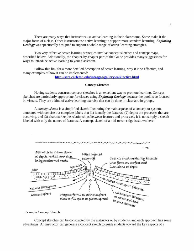
A concept sketch is a simplified sketch illustrating the main aspects of a concept or system,
annotated with concise but complete labels that (1) identify the features, (2) depict the processes that are
occurring, and (3) characterize the relationships between features and processes. It is not simply a sketch
labeled with only the names of features. A concept sketch of a mid-ocean ridge is shown here.
Example Concept Sketch
Concept sketches can be constructed by the instructor or by students, and each approach has some
advantages. An instructor can generate a concept sketch to guide students toward the key aspects of a

9
subject and show how the aspects are related. When students construct concept sketches, it forces them to
put things in context and to understand the relationships between the various features shown. Concept
sketches also make good fodder for quizzes and exams – they clearly reveal what students know and do
not know, and they are quick to grade.
See the separate document “Concept Sketches” for a more detailed description of concept
sketches and specific suggestions about how to use them with Exploring Geology.
Concept Maps
Concept maps are visual representations of linkages/connections between major concepts/ideas.
They are excellent tools that provide instructors with guidance as they prepare to teach class. That is why
we have provided many of them in the chapter-by-chapter part of this Guide. If you wish to modify the
maps we provide, we have provided them in PDF and EPS format – so they can be opened and edited
using Adobe Illustrator, Corel Draw, or any other graphics program. Alternatively, download
CMAPTools – the software we used to create these maps at http://cmap.ihmc.us/conceptmap.html. They
are also provided in PowerPoint files on ExploringGeology.com.
The concept maps provided in the chapter-by-chapter part of this Guide are intended to help you
as you organize your class and lectures. Many possible cross connections between ideas/concepts have
been omitted for simplicity, so some appear linear, like the one shown here. Others are “spider diagrams”
centered on a central concept. You may choose to present/cover information from top to bottom, left to
right, or in any other order – the maps will help you see logical connections and paths to follow.
Most important: having students construct concept maps is an excellent way to promote learning.
The process of creating the maps forces students to identify the most important aspects of a topic while
synthesizing and integrating information and ideas. A concept map involving wind erosion and deposition
is shown here (Concept Map 13.4).

10
Concept Map 13.4
We strongly recommend AGAINST handing out pre-made concept maps to students. If you do
this, they will just memorize what you give them, and the learning opportunity is gone. Instead, give them
a list of concepts and have them make their own maps. And, don’t show them the complicated concept
maps as part of lectures – keep things simple and on point.
Click below to get a more detailed description of concept maps and how to use them to promote
learning:
http://serc.carleton.edu/introgeo/assessment/conceptmaps.html
Time Management and Giving Students More Responsibility
Active learning involving concept sketches, concept maps, or other activities in the classroom
promotes deeper learning, but consumes time. This means you may not be able to lecture on everything
you want students to learn. This is what makes the Exploring Geology textbook and the What-To-Know
Lists so valuable. They help students learn on their own by specifically identifying things from each
chapter that students are responsible for knowing — even if the subject is never brought up in class. This
places some responsibility for learning and self-monitoring on the student — one of the “best practices”
recommended by education experts today. It also means that instructors can expect students to learn
content beyond what time allows them to include in lectures, even with a full-speed lecturing approach.
An instructor using this approach must include some test questions about subjects that were identified on
the What-To-Know List but not lectured on, or else students quickly figure out they only need to study
lecture notes. Research conducted by the authors and others demonstrate that most students can learn on
their own using Exploring Geology, even for material that is never covered in lecture.

11
Chapter Overviews
The following pages summarize the material presented in each chapter in a few sentences, list the
main topics covered, and summarize the main goals of the chapter. Then we list learning objectives
derived from the Before-You-Leave-This-Page list on each two-page spread, present concept maps and
give suggestions for ways to approach teaching the material. We also recommend possible in-class
activities, and provide other information.
Note that some of the concept maps are difficult to read at the scale presented. These can be
downloaded as separate images at the ExploringGeology.com website. This site also has (1) a separate
PDF document with large versions of all the maps, and (2) a PowerPoint file that has one concept map per
slide or that split more complex maps into two slides.
There are other links in the following pages, too. All will open in a new window, which you only
need to close to get back to where you started.
12
Chapter 01 – The Nature of Geology
SCOPE
This chapter is designed to be an engaging introduction to geology. It introduces students to a
number of different topics, all meant to convey the idea that geology is important and exciting. It covers
fundamental topics, like the rock cycle and origins of rocks, to provide a foundation for subsequent
chapters. Additionally, the chapter should help students understand that geology is a dynamic science that
involves connections and interactions with other sciences such as biology.
The main topics covered are:
1. Geology as a Science
2. The Practical Aspects of Geology
3. Overview of the Geology of Earth
GOALS
After reading this chapter, students should be able to:
• Explain the importance of geology in their daily lives.
• Describe some of the most important geological materials and processes.
• Describe how geology interacts with Earth’s biosphere and atmosphere.
(see the What-To-Know List for specific objectives for each two-page spread)

13
THEMES
The main concepts in this chapter are shown in Concept Map 1.1. The map appears as a spider
diagram because the ideas are, in some cases, not directly linked to one another.
Concept Map 1.1
There is no reason to lecture on all of the ideas/concepts presented. As is the case for most
content in the textbook, most spreads in the chapter will stand on their own if an instructor chooses not to
cover that material during lecture.
SUGGESTED IN-CLASS ACTIVITIES
• The Henry Mountains photograph in Spread 1.1 works extremely well for a short initial active-learning
activity. It will get students to begin to understand how geology affects their lives. As described in the
Notes field in the PowerPoint file, ask students to think about how the geology in the scene is
influencing the lives of the horses and cows.
• The Connections spread (1.9) is a good spread to further convey the relevance of geology, and you may
wish to spend some time talking about the geology around Rapid City. Be sure to show good photos of
the National Parks and Monuments (Devils Tower, Jewel Cave, Wind Cave, Badlands, Mt. Rushmore)
as well as the Homestake Mine and Harney Peak. It is also worth showing pictures of the Mammoth
site in Hot Springs, South Dakota. (Many photos of all these places are available on the web if you
14
don’t like the ones provided with the textbook or in this Guide.) There is so much in the Black Hills –
students should be impressed by the diverse and spectacular geology.
• The Connections spread (1.10) is a good one to use as an in-class group exercise, but the aerial imagery
used to construct the 3D perspective is bit out of date since the region around St. George has grown in
population faster than just about anywhere else in the country during recent years. You can use this as
an opportunity to discuss how humans interact with geology, such as viewing the area in Google Earth
to discuss the changes and the challenges of a rapidly growing population (in a desert). The link in the
In-Class PowerPoint file drapes the aerial imagery from the textbook onto Google Earth topography,
but you can view Google Earth’s more recent (but perhaps less detailed) data by toggling off the St.
George layer in your Temporary Places panel in Google Earth.
15
Chapter 02 – Investigating Geologic Questions
SCOPE
This chapter is an introduction to geological investigations and to the scientific method. It
introduces students to the nature of observations, data and data collecting, predictions and hypotheses,
and scientific theories. Although there are many different kinds of geological investigations, many of the
spreads are focused on interpreting geological landscapes – in large part because landscapes are
emphasized in many subsequent chapters. This works out well because many/most students have seen
geologic landscapes, whereas they may not be familiar with some of the other things that geologists
study. The main topics covered and relevant spreads are:
1. Investigating Landscapes and Other Geologic Features
• 2.0 Investigating Geologic Questions
• 2.1 What Can We Observe in Landscapes?
• 2.2 How Do We Interpret Geologic Clues?
• 2.3 How Do We Depict Earth’s Surface?
• 2.4 How Do We Depict Earth’s Heights, Slopes, and Subsurface Geology?
2. The Scientific Method and Geological Science
• 2.3 How Do We Depict Earth’s Surface?
• 2.4 How Do We Depict Earth’s Heights, Slopes, and Subsurface Geology?
• 2.5 How Are Geologic Problems Quantified?
• 2.6 How Do Geologists Refer to Rates and Time?
• 2.7 How Do We Investigate Geologic Questions?
• 2.8 How Do Scientific Ideas Get Established?
• 2.9 What Does a Geologist Do?
• 2.10 Connections: How Did This Crater Form?
• 2.11 Investigation: What Is the Geologic History of Upheaval Dome
GOALS
After reading this chapter, students should be able to:
• Explain the scientific method and how scientific theories are established.
• Describe some of the ways that geologists study geology, and give examples of some different kinds of
data they might collect.
• Explain the differences between field and laboratory studies, between quantitative and qualitative data,
and between direct observations and remote sensing and experimental studies. (see the What-To-Know List for specific objectives for each two-page spread)
THEMES
Geological Landscapes
The concepts shown in Concept Map 2.1 include all those that a geologist might encounter when
investigating an outcrop or region. Thus, one excellent way to approach these concepts is by example.
The book does this by using photographs of landscapes from the arid western United States. But, we
recommend that you substitute your own examples – use the local geology where you are, if possible and
appropriate. The main points to make are that (1) good scientists take care to make careful observations,
(2) there are many kinds of geologic data, and (3) geologic data can be gathered and depicted in many

16
ways.
Concept Map 2.1
The Scientific Method and Geological Investigations
The left-hand side of Concept Map 2.2 is the standard summary of the scientific method. The
right-hand side expands a bit more on the nature of geological studies, and of observations, data, and
evidence. Perhaps the best way to present these ideas is by example. For example, you can describe how
the meteorite impact hypothesis for the extinction of dinosaurs is now on its way to becoming (or maybe
it is there?) an accepted scientific theory.
Concept Map 2.2

17
SUGGESTED IN-CLASS ACTIVITIES
18
• Show a photograph (like the one from Spread 2.1) and have students observe it. Working with nearby
students, they should discuss the differences between observations and interpretations, and between the
qualitative and quantitative data they could collect at the site.
• As noted above, the concepts in this chapter are best introduced by example. So, as you give your
examples, ask students some pointed questions. For example, if you talk about the extinction of
dinosaurs (alluded to above) you could ask them what kind of evidence they would look for to “prove”
this hypothesis. And you can ask them if it is really possible to absolutely prove such things.
• The Connections spread (2.10) is intriguing to students and connects well with the dinosaur extinction
theme. It also is a good warm-up for the Investigation (2.11) – which is a very good in-class exercise.
Exploring Geology 4th Edition Reynolds Solutions ManualFull Download: http://testbanklive.com/download/exploring-geology-4th-edition-reynolds-solutions-manual/
Full download all chapters instantly please go to Solutions Manual, Test Bank site: testbanklive.com