Embed Size (px)
Citation preview

Revised: July 2015
1
INSTRUCTIONS TO COMPLETE A SITE REGISTRATION APPLICATION FORM
FOR THE WV/NPDES GENERAL PERMIT FOR CONSTRUCTION STORMWATER
ACTIVITY (THREE ACRES AND GREATER ONLY)
A. GENERAL INSTRUCTIONS
The Division of Water and Waste Management (DWWM) has developed and issued a General WV/NPDES Water Pollution Control permit to regulate stormwaters containing sediment flowing into the waters of the State from discharges associated with construction activity. This General Permit was issued on December 4, 2012, became effective on January 4, 2013, and will expire on January 4, 2018. Certain establishments which discharge sediment laden stormwater and fall under the definition of "Stormwater Associated with Industrial Activity" can elect to be regulated under the General Permit. Those establishments must file a Site Registration Application Form with the DWWM. Individuals will be regulated under the General Permit only if they agree to do so, and if they satisfy the registration requirements. The DWWM reserves the right to require any individual to obtain a facility-specific WV/NPDES Permit. Individuals not wishing to be regulated by the General Permit are required to apply for and obtain an individual permit. All permittees will be required to develop a Stormwater Pollution Prevention Plan (SWPPP) for the project to be covered by the permit. Upon receipt of the site registration application form along with the Erosion and Sediment Control Plan, which together comprise the SWPPP, a review will be conducted by the DWWM to determine if the information provided meets the minimum requirements of the permit. Persons with questions regarding the General Permit for Construction should contact the DWWM, Construction Stormwater Team in Charleston at (304) 926-0495. B. WHO MUST APPLY
Any establishment, pursuant to Chapter 22, Article 11, where, stormwater associated with construction activity is or may be discharged into the waters of the State or, where designated by the Director, is a contributor to a violation of the Water Quality Standards or that result in a significant pollutant loading to the receiving waters must apply. Any person proposing a construction activity, three acres or greater of land disturbance in size, shall submit a site registration application form. Persons proposing a minor construction project between one and less than three acres should use the Notice of Intent forms that can be obtained from the Construction Stormwater website http://www.dep.wv.gov/wwe/programs/stormwater/Pages/sw_home.aspx. or by request from the Charleston office. Construction of single family residences by the homeowner or homeowner’s contractor requiring land disturbances less than three acres in size are provided coverage under the General WV/NPDES Water Pollution Control Permit and do not require application for

2
registration. However, all other terms and conditions of the General Permit still apply except for the Notice of Termination requirement. When the construction activity is owned by one person but operated by another, it is the responsibility of the owner to obtain the permit.
C. WHERE TO APPLY
Beginning on July 1, 2011, electronic submittal for construction stormwater site registration applications is required. The technical requirements for the ePermitting process are an internet connection, an email account, and internet browser software such as Microsoft’s Internet Explorer, Version 7.0 or higher. You may visit the WV DEP website at https://apps.dep.wv.gov/eplogin.cfm to sign up for a login id and/or view information regarding ePermitting. If you do not have the above technical requirements and/or are unable to participate in the mandatory ePermitting process, you are required to submit a letter to the DWWM advising us as to the reason why. The DWWM will access the reasoning provided and will provide a written response. If you are approved for a hard copy submittal, please submit the following materials to the address below:
• One (1) original Site Registration Application Form with the application fee and signature
• Two (2) copies of the Site Registration Application Form
• Three (3) copies of the SWPPP with accompanying plans and drawings
Division of Water and Waste Management
Construction/NPDES
601 57th
Street, SE
Charleston, WV 25304
D. WHEN TO APPLY
The application for construction activities requiring coverage must be submitted at least 60 days prior to starting the project, except as follows. In the following scenarios, applications must be submitted at least 100 days prior to start of construction in order to allow time for the public notice procedure:
• projects with 3 acres or greater disturbance that discharge to Tier 3 waters
• the project will disturb 100 or more acres
• the project will have an initial grading construction phase of one year or greater
• if an applicant submits a new registration or modification under the general permit that is part of a common plan of development with open registrations that will collectively disturb 100 or more acres in a drainage area, then that new registration or modification must go out to public notice.
If any of these conditions apply to the project, then a notarized, signed Statement For Billing form must be submitted with the application. After the application has been reviewed and determined Technically Complete, the public notice process will begin. The notice of the draft

3
approval will be published in the local newspaper. A thirty-day comment period will begin the day after the notice has been published. E. FEES
Prior to submitting the application, you may wish to obtain a copy of the Legislative Rules of the Division of Environmental Protection, Title 47, Series 26, Water Pollution Control Permit Fee Schedules, effective May 4, 2000. A copy of these Rules is available from the Secretary of State's Office, State Capitol Building, Charleston, WV 25305. To help the applicant, the application fees have been calculated by acreage in each precipitation zone in West Virginia. These application fees have been prepared using the NPDES Fee structure to simplify the application submittal process. The following table lists the application fee by zone for acres of disturbed area. To determine which zone the project is located refer to the Precipitation Zone Map.
PERMIT APPLICATION FEES BY PRECIPITATION ZONE
ZONE 1 ZONE 2 3-3.9 Acres = $ 700 3-4.9 Acres = $ 700 4-38.9 Acres = $ 1170 5-43.9 Acres = $ 1170 39-76.9 Acres = $ 1400 44-87.9 Acres = $ 1400 77 Acres or more = $ 1750 88 Acres or more = $ 1750
ZONE 3 ZONE 4 3-3 .9 Acres = $ 700 3-4.9 Acres = $ 700 4-31.9 Acres = $ 1170 5-45.9 Acres = $ 1170 32-63.9 Acres = $ 1400 46-90.9 Acres = $ 1400 64 Acres or more = $ 1750 91 Acres or more = $ 1750
Send Application fees to Division of Water and Waste Management, Construction/NPDES,
601 57th
Street SE, Charleston, WV 25304
PRECIPITATION ZONES IN WEST VIRGINIA

4
LINE BY LINE INSTRUCTIONS FOR COMPLETING
THE SITE REGISTRATION APPLICATION FORM 1. PROJECT NAME
The project name is the official name such as "River City Parking Garage Site Preparation" or "River City Subdivision". 2. APPLICANTS NAME
The applicant is the corporation, company, governmental entity or individual (owner) with day-to-day oversight of the project and who is supplying the capital to finance the project. The owner is responsible for obtaining and complying with the permit. An operator of a construction site is the person (or persons) responsible for obtaining coverage under an NPDES stormwater permit for construction activity, and complying with the permit requirements. An operator is the person or persons that meet either of the following criteria:
Has operational control of construction project plans and specifications, including the ability to make modifications to those plans and specifications; or
Has day-to-day operational control of those activities at a project which are necessary to ensure compliance with a stormwater pollution prevention plan (SWPPP) for the site or other permit conditions (e.g., they are authorized to direct workers at a site to carry out activities required by the SWPPP or comply with other permit conditions).
FEDERAL EMPLOYER IDENTIFICATION NUMBER (FEIN) – If you have a FEIN enter it on this line. All partnerships, corporations, sole owners or companies with employees must have a FEIN.
ADDRESS -- The address of the APPLICANT, OFFICIALS NAME, AND COMPANY TITLE (typed or printed). TELEPHONE -- The number where the applicant can be reached. This person should be familiar with project, if not, give name of a knowledgeable person. E-MAIL ADDRESS -- The email address of the applicant. DWWM now sends out all approval letters electronically. 3. CONTRACTOR
The contractor is the person or firm that will be doing the earthmoving and may also have day-to-day control over operations. The contractor can be the same as the applicant, but often the contractor is a different firm. If the contractor is unknown at time of application, the applicant should provide this information to DWWM when a contractor has been hired.

5
4. PREPARER’S NAME
The preparer is the person or firm that has written the Stormwater Pollution Prevention Plan (SWPPP). This may be a consultant or it may be the applicant. Include the name of the individual who should be the point of contact. E-MAIL ADDRESS -- The email address of the person that prepared the plan. DWWM now sends out all approval letters electronically and plan preparers are carbon copied on email approvals. 5. TOTAL ACREAGE TO BE DISTURBED, RAINFALL ZONE AND FEE
Include ALL disturbed areas directly related to construction of the entire project (offsite borrow areas, offsite waste sites, access roads, utility installation, sediment controls etc.). For subdivisions, this is total area of disturbance to be conducted by the developer, such as installation of utilities, roads, and other infrastructure, construction of sediment control facilities, and any other grading, fill or excavation required to prepare the site. If the developer is also responsible for constructing the home sites, that area of disturbance will need to be included. Provide the rainfall zone in which the project occurs and the fee submitted. Refer to page 3 of these instructions. 6. LATITUDE, LONGITUDE AND TOPOGRAPHIC MAP
Locate accurately the center of the construction site on a United States Geologic Survey 7.5 minute topographic map. For precision, latitude and longitude should be given to the nearest seconds. (Example: latitude 38° 18' 46", longitude 81° 34' 13"). The local Natural Resources Conservation Service office may help if needed. Topographic maps can be obtained online http://wvgis.wvu.edu/ and several other sources can be found at http://nationalmap.gov/gio/viewonline.html. A copy of the part of the topographic map where the site is located must accompany the permit application. The minimum information required on each map will be the name of the map, the boundary of the site and a north arrow. 7. NEAREST TOWN, COUNTY, AND COUNTY ROUTE
List the name of the closest town as shown on the topographic map. List the county where the project is located. Note: projects located in Berkeley, Grant, Hampshire,
Hardy, Jefferson, Mineral, Morgan, or Pendleton Counties must complete the Chesapeake Bay
Addendum and submit it with the application.
The official Division of Highways (DOH) designation may be found on a road sign at the nearest intersection, on the DOH county road map, or check with county maintenance garage. 8. RECEIVING STREAM(S)
Provide the official name from a USGS topographic map of all streams that will receive a stormwater discharge. If the discharge is not into a named stream, report the stream as an unnamed tributary of the

6
first named stream that it flows into. (Example: Unnamed tributary (UT) of Laurel Run or UT of Laurel Run of the New River). In urban areas the discharge may be to a municipal storm sewer. Identify the operator of the storm sewer system, such as "River City" and the ultimate receiving water, e.g. the Flowing River.
9. PROJECT DESCRIPTION
Provide a description of the nature of the construction activity. This description should include the total area of the project site, the part of the site that is expected to be disturbed and a description of all activities that will cause earth disturbance. 10. ESTIMATED START AND COMPLETION DATES FOR PROJECT
Provide the anticipated start and completion dates (month/year) for the proposed project. For subdivisions, completion of the infrastructure, not house build-out should be provided unless the applicant is constructing the houses on individual lots. Applicants and preparers should remember that applications must be submitted at least 60 days (90 days for projects that go out to public notice) prior to the start of construction.
11. EXCAVATION, WASTE/BORROW SITE & SOILS REPORT
Furnish an estimate of the cubic yards of material to be excavated and the amount of any possible off site waste and/or borrow. Off-site waste and borrow sites are considered part of the permitted site and erosion and sediment control plans should be submitted for these areas. Provide a soils report for the project area.
12. RELATIVE TIME LINE OF CONSTRUCTION ACTIVITIES
Provide a relative time line of the primary construction activities (i.e. number of weeks). These major activities include clearing, grubbing, rough site grading, final grading, sediment control practices, seeding and mulching, removal of sediment control devices, etc. If the major phase of grading will last for 1 year or longer, then please submit a Signed Statement for Billing with the application so that the project can be sent out for public notice prior to approval. The Statement for Billing form may be obtained from the construction stormwater website or by calling our office at (304) 926-0495. See Section D of the instructions for more information regarding the public notice process.
13. NARATIVE DESCRIPTION OF EROSION AND SEDIMENT CONTROLS
The Stormwater Pollution Prevention Plan (SWPPP) and specifically the sediment and erosion controls for construction activities in this permit have five goals:
1. Limiting the amount of total disturbance 2. Diverting upslope water around disturbed areas of the site 3. Limiting the exposure of disturbed areas to the shortest duration possible 4. Controlling internal water and runoff 5. Removing sediment from stormwater before it leaves the site.

7
The sequence of construction (Item 14) describes the timing and manner of installation of the erosion and sediment control. 13 A. VEGETATIVE CONTROL (Temporary and Permanent)
This section of the narrative is a discussion of the vegetative practices that will be utilized during all phases of the project. As always, the initial effort should be to limit the amount of area disturbed by maintaining as much of the original vegetative cover as possible. Vegetative Practices - a description of interim and permanent stabilization practices, including site specific implementation schedules of the practices shall be provided. Site plans should ensure that existing vegetation is preserved where attainable and that disturbed portions of the site are stabilized as rapidly as possible. Efforts should be made to limit disturbance on steep slopes, limit soil compaction, and preserve topsoil where feasible. Stabilization practices may include: temporary seeding, permanent seeding, mulching, geotextiles, sod stabilization, vegetative buffer strips, protection of trees, preservation of mature vegetation, and other appropriate measures. Also include in the plan seedbed preparation requirements and the type and amount of soil amendments necessary to establish a healthy stand of vegetation. The most useful, cost effective and productive erosion control is a vigorous vegetative cover. Keys to vigorous vegetation are good initial soil conditions, moisture, temperature, correct pH, available macro and micronutrients, organic material, mulch and runoff control. The use of native vegetation is encouraged and any vegetation plan should be in compliance with the West Virginia Noxious Weed Act (Code of West Virginia Chapter 19, Article 12). Effective sediment control cannot occur without good erosion control. It cannot be stressed enough that the sooner an area is seeded the better. All slopes should be seeded and mulched as soon as final grade is reached. Mulching with straw or hay contributes some organic material, retains moisture, and moderates temperatures. A record of the dates when major grading activities will occur, and when construction activities temporarily or permanently cease on a portion of the site, and when stabilization measures will be initiated shall be included in the plan. Clean water diversions must be stabilized prior to becoming functional. Stabilization methods for all such diversions must be provided. Except as noted below, stabilization measures shall be initiated as soon as practicable in portions of the site where construction activities have temporarily or permanently ceased, but in no case more than 7 days after the construction activity in that portion of the site has temporarily or permanently ceased.
(a) Where the initiation of stabilization measures by the 7th day after construction activities temporary or permanently ceases is precluded by snow cover, stabilization measures shall be initiated as soon as conditions allow.
(b) Where construction activity will resume on a portion of the site within 14 days from
when activities ceased, (e.g., the total time period that construction activity is temporarily halted is less than 14 days) then stabilization measures do not have to be initiated on that portion of the site by the 7th day after construction activities have temporarily ceased.
8
(c) Areas where the seed has failed to germinate adequately (uniform perennial vegetative cover with a density of 70%) within 30 days after seeding and mulching must be reseeded immediately, or as soon as weather conditions allow.
The following items should be considered before vegetative practices are applied.
• Temporary grass seed mixtures and rate of application.
• Permanent grass seed mixtures and rate of application.
• Seed bed preparation.
• Type of mulch.
• Mulch rates in tons per acre or pounds per 1000 square feet. Natural Vegetative Buffers Natural vegetative buffers are to be provided adjacent to receiving streams or other waters on the project site. Natural vegetative buffers should be a minimum of 50 feet, however, a minimum of 100 feet is required if intended as a stand-alone erosion and sediment control practice. The location and limits of proposed buffers shall be delineated on the plans. The location and limits of buffers must also be clearly marked on the construction site to prevent encroachment during construction. The natural vegetative buffer requirement may be waived for the conditions listed in Section G.4.e.2.A.i.e. of the General Permit. A written description and justification shall be provided in the plan when buffers are not provided or encroachment in the buffer is proposed. 13 B. STRUCTURAL CONTROLS
Prior to excavation, the contractor will need to install the appropriate structural sediment controls. Structural practices are designed to accomplish three goals. The first is to divert water from undisturbed upslope areas around the disturbed area. Second is to reduce flow path lengths and directions. And third, to remove sediment from runoff before it leaves the site. There are several ways of accomplishing sediment removal, including filtering through silt fence or some of the new silt fence replacement products on the market, ditch checks and check dams and by trapping and settling sediment in traps or basins. Structural devices (especially silt fence) must be installed properly and must be maintained and cleaned out at regular intervals. All sediment-laden water must pass through an appropriate sediment-trapping device. For locations on a site, which have a drainage area of 5 acres or less, a sediment trap that provides a storage volume equal to 3,600 cubic feet per acre of drainage area shall be installed. Half of the volume of the trap will be in a permanent pool and half will be dry storage. The inlet(s) and outlet(s) of sediment traps (and basins) must be protected against erosion by appropriate material such as riprap or other similar media. If necessary, diversions will be used to direct runoff to the trapping structure. Sediment traps do not require an engineering design for the outlets. The minimum size for the weir outlet is 4 feet wide and as a rule of thumb the weir should be 2 feet wide plus another 2 feet for every acre of drainage. For drainage areas of greater than five acres, a sediment basin providing 3,600 cubic feet per drainage acre shall be installed. Half of the volume of the basin will be in a permanent pool and half will be dry

9
storage. Sediment basins must be able to dewater the dry storage volume in 48 to 72 hours. Dewatering structures must withdraw from the surface, unless infeasible. This typically means the use of a skimmer device, however, they may be alternative measures that would comply with this requirement. When skimmer devices are used, the half wet/half dry requirement will be waived and draw down time should be maximized. Justification must be provided for any alternative outlet/dewatering structure design. A sediment basin must be able to pass through the spillway(s) a 25-year, 24-hour storm event, and still maintain at least one foot of freeboard. The emergency spillway will be constructed in original ground. Embankments must be built using best engineering and construction standards. Provide all calculations used to size the sediment trapping structures. For drainage locations served by a common drainage location where a detention structure providing 3,600 cubic feet of storage is not attainable, additional sediment and erosion controls within the project area are required in lieu of the required sized sediment basin. Justification and a narrative
description of the additional measures proposed must be provided for use of any practice(s) other
than properly sized sediment basins or traps. Sediment trapping structures will be eliminated, and the area properly reclaimed and stabilized, when the structures are no longer needed (i.e. when the entire contributing drainage area is completely stabilized), unless the structure is converted into a permanent stormwater detention/retention structure. All trapped sediments will be disposed of in an upland area where there is no chance of entering nearby streams. Breaching the embankment to dewater the structure is not permitted. Dewatering and removal of the structure should not cause a violation of water quality standards. Provide a description of the procedures that will be used in removing these structures and the time frame. Straw/hay bales will not be approved for sediment control. Design and build fills so that the face of the fill is protected from erosion. Install diversions to divert runoff away from fill slopes to conveyance measures such as pipe slope drains or stabilized channels without eroding the face. As the fill comes up, slope the top (or berm it) to direct water away from the slope and to a stable conveyance. Seed and mulch the slope face every 7 days or 15 feet of fill. Silt fence must not be used in areas where concentrated flows can be expected or to control areas of greater that 1/4-acre per 100 feet of fence. It is also imperative that silt fence is installed on the contour, perpendicular to the flow of the water. The following is a sample of some of the practices that can be utilized in the SWPPP.
1. Silt fence/Super Silt Fence 2. Check dams 3. Sediment basins/sediment traps 4. Diversions and waterways 5. Slope drains 6. Earth dikes/berms 7. Inlet protection
8. Outlet protection 9. Temporary stream crossing 10. Ditch checks 11. Level spreader 12. Rip-rap 13. Mulch 14. Land grading
All devices must be cleaned out when sediment occupies half of the wet capacity of the structure. Access to the structure for cleanouts must be maintained.

10
Pumped water from foundations, abutments, utility trenching, sediment basin/trap removal and other dewatering operations must be treated before entering a stream or waterway. There are several new products on the market that provide excellent sediment removal from pumped water. DO NOT REMOVE SEDIMENT CONTROLS UNTIL THE CONTRIBUTING
DRAINAGE AREA IS STABILIZED.
13 C. DISCHARGES TO TIER 3.0 WATERS
Construction activities discharging to Tier 3.0 waters will go through the Tier 3.0 antidegradation process. A list and maps of Tier 3.0 waters is available on the agency website at http://www.dep.wv.gov/WWE/Programs/stormwater/csw/Pages/home.aspx.
13 D. DISCHARGES TO IMPAIRED WATERS
Sites discharging to impaired waters must demonstrate consistency with the approved Total Maximum Daily Load (TMDL) and applicable state law. Impaired waters are those that do not meet applicable water quality standards and are listed on the Clean Water Act Section 303(d) list. The current list of 303(d) waters and those with approved TMDLs is available on the DEP website or by request from this office. Pollutants of concern are those constituents for which the water body is listed as impaired. Discharges of pollutants of concern to impaired water bodies for which there is an approved TMDL are not eligible for coverage under this permit unless they are consistent with the approved TMDL. TMDL’s that have established acreage limits for Stormwater Construction General Permit Registrations require no special conditions provided the acreage cap has not been met for the receiving stream other than the registration only being issued for one (1) year . If the acreage cap has been reached, additional area may be permitted if effluent limitations and monitoring is required consistent with limits established by the TMDL. Within six months of the TMDL approval, permittees must incorporate any limitations, conditions, or requirements applicable to their discharges necessary for compliance with the TMDL, including any monitoring or reporting required by DWWM rules, into their SWPPP in order to be eligible for coverage under this general permit. The Director may elect to set effluent limitations and require discharge monitoring and public notice for any project within TMDL acreage limited areas. Sites that discharge into a receiving water which has been listed on the Clean Water Act 303(d) list of impaired waters, and with discharges that contain the pollutant(s) for which the water body is impaired, must document in the SWPPP how the BMPs will control the discharge of the pollutant(s) of concern. 13 E. ENDANGERED AND THREATENED SPECIES AND STATE HISTORIC
PRESERVATION OFFICER
If the project will discharge to a stream where a federally endangered or threatened species or its habitats are present, the applicant should contact the U.S. Fish and Wildlife Service to insure that requirements of the Federal Endangered Species Act are met. A list of streams in West Virginia

11
with the presence or possible presence of endangered/threatened species (Attachment A) is provided to assist applicants in determining when that issue should be considered. For those projects that may impact historic preservation sites, the permittee shall coordinate the project with the State Historic Preservation Officer.
13 F. MAINTENANCE A detailed plan and schedule for maintenance of all permanent and temporary sediment control structures is required by the permit. A description of procedures to maintain in good and effective condition and promptly repair or restore all grade surfaces, walls, dams and structures, vegetation, erosion and sediment control measures and other protective devices must be identified on the site plan. At a minimum, procedures in the plan shall provide that all erosion controls on the site are inspected at least once every seven calendar days and within 24 hours after any storm event of greater than 0.5 inches of rain per 24 hour period.
14. SEQUENCE OF CONSTRUCTION
One of the fundamental parts of the SWPPP is the sequence of construction. The sequence of construction directs the timing of the installation of each sediment and erosion control practice within the framework of the construction project. Construction jobs usually fall into segments defined by time and space. The first operation is clearing and grubbing and/or stripping of topsoil. The sequence of events directs the contractor to concurrently install the first sediment control devices. Other critical events are; reaching final grade and seeding and mulching within seven days, ditch line stabilization and outlet protection, interim sediment control such as ditch checks, sediment traps and basins and temporary diversions, temporary seeding, and directing runoff away from fill slopes in non-erodible waterways, pipes or underdrains. A basic sequence of events for Erosion and Sediment Control and Stormwater Management includes a plan and time schedule for: clearing and grubbing, installation of temporary stormwater control, installation of temporary sediment control structures, seeding and mulching schedules, installation of permanent erosion control, installation of permanent stormwater control, inspection schedules, maintenance schedules, and removal of temporary erosion and sediment control structures. Subdivisions need to adhere to a strict sequence. At many subdivisions lack of space limits the installation of properly sized sediment trapping structures. Erosion control (i.e. seeding and mulching) and smaller trapping structures such as ditch checks, small sediment traps, silt fence and check dams may be the only BMPs available for use. Road cuts and fills and ditches must be stabilized as soon as possible. A less ambitious road construction schedule by building the project in phases and continuous reclamation will greatly simplify sediment control.
15. DETAILED SITE MAP(S) OF EROSION AND SEDIMENT CONTROLS
Provide site maps indicating drainage patterns and slopes prior to construction and anticipated conditions after grading activates. For projects with several phases of construction, an erosion

12
and sediment control site map for each phase should be provided. Site maps should identify the limits of disturbance, topsoil stockpiles, waste areas, borrow sites, natural vegetative buffers and the locations of all sediment control structures and erosion controls identified in the narrative. Site maps should be a 1”=100’ scale and must have minimum five-foot existing and proposed contours. Typical details for all proposed erosion and sediment best management practices should also be included in the site plans. 16. SITE MAP OF FINAL STORMWATER
Attach a site map that includes all permanent stormwater management facilities, the location of impervious areas after construction is complete, and final stormwater routing. Permanent stormwater structures include all ditches, pipes and culverts, basins and any other anticipated stormwater management structure. Delineate and identify each watershed and sub-watershed influenced by the project. Label or identify structures. (See next section.)
17. THE PRE- AND POST-DEVELOPMENT PEAK DISCHARGES AND
DRAINAGE MAPS
The following information must be submitted as part of the SWPPP for the General Permit.
1. Pre- and post-development drainage maps of the project area with each discharge point identified.
2. Pre-development peak discharge in cubic feet per second (cfs) for a 1 year, 24-hour storm at each discharge point (may be waived for projects expected to have no increase in peak discharges).
3. Post-development peak discharge in cubic feet per second (cfs) for a 1 year, 24-hour storm at each discharge point (may be waived for projects expected to have no increase in peak discharges).
4. Methodology and calculations. 5. Projects that require discharge monitoring due to TMDL effluent limitations shall provide
latitude and longitude (to the nearest second) location information for each construction discharge point.
18. NARRATIVE DESCRIPTION OF FINAL STORMWATER MANAGEMENT
AND POLLUTION PREVENTION
The applicant shall submit a description of measures that will be installed during construction to control stormwater discharges after the project is completed. The completed project shall convey stormwater runoff in a manner that will protect both the site and the receiving stream from post-development erosion. All waterways and other runoff conveyance structures shall be permanently

13
stabilized as appropriate for expected flows. In developing structural practices for stormwater control, the operator shall consider the use of, but not limited to: infiltration of runoff onsite; flow attenuation by use of open vegetated swales and natural depressions; stormwater retention structures and stormwater detention structures. A combination of practices may be utilized. Low impact development technology is encouraged to minimize alteration of the pre-development site hydrology. Velocity dissipation devices shall be placed at the outlet of all detention or retention structures and along the length of any outlet channel as necessary to provide a non-erosive velocity flow from the structure. Projects located in areas that have local government requirements and/or criteria for post construction stormwater management should meet those requirements. The permittees shall be required to meet any local government or other agency requirements for stormwater management and provide verification thereof. The applicant shall submit all calculations, watershed mapping, design drawings, and any other information necessary to explain the technical basis for the stormwater management plan. Design procedures shall follow professionally accepted engineering and hydrologic methodologies. Permanent stormwater management structures that will impound water (detention/retention basins or similar structures) shall be designed and certified by a Registered Professional Engineer. These structures shall also have a certified as-built drawing submitted with the Notice of Termination at the completion of the project. Permittees are only responsible for the installation and maintenance of stormwater management facilities prior to final stabilization of the site and termination of General Permit coverage; however the entity responsible for post-development maintenance should be identified. The following items are the minimum that must be considered in the stormwater management: 1. Existing and proposed watersheds delineated and labeled. Label and relate culverts,
ditches, ponds, etc. to these watersheds. 2. Existing water flow paths. 3. Proposed water flow paths. 4. Permanent stormwater pollution control measures. These measures should be installed as
soon as practical. a. Permanent seeding specifications. b. All waterways must be permanently stabilized: i.e. ditch line protection w/grass and/or
a rolled erosion control blanket specifically designed for concentrated water flows and/or properly sized rip-rap. Specific engineering requirements are needed to insure that the waterway will remain stable and not erode.
5. Waterway design calculations. Peak discharges of the watershed and flow characteristics of each waterway must be calculated to insure proper capacity. Use labels from site map to identify each calculation. A 10 year, 24-hour storm should be used to calculate sizes of all permanent
waterways and culverts. 6. Outlet protection from a pond, waterway, diversion or a culvert must extend as a properly
stabilized waterway to a natural stable waterway.

14
7. Pipe and culvert sizing and outlet protection. Use labels from site map to identify each calculation.
8. Stormwater detention or retention structures design and calculations. Use labels from site map to identify each calculation.
Some resources available on the web are:
WV DEP’s Construction Stormwater Web Site
http://www.dep.wv.gov/wwe/programs/stormwater/Pages/sw_home.aspx
West Virginia Erosion and Sediment Control Best Management Practice Manual 2006
http://www.dep.wv.gov/WWE/Programs/stormwater/csw/Pages/ESC_BMP.aspx
EPA's Stormwater Web Site
http://water.epa.gov/polwaste/npdes/stormwater/
19. PERMANENT STORMWATER MANGEMENT FACILITY
Check the appropriate box to indicate whether or not you have a permanent stormwater management facility on this project. If you do have a permanent stormwater management facility on this project, please select the BMPs that will be used for the project. In addition, please indicate the amount of drainage area (in acres) that will flow through each BMP. Definitions for each BMP can be found at the end of the instructions. 20. PUBLIC NOTICE SIGN
Section G.4.b.5 of the General Permit states that “Within 24 hours of filing an NOI (one to less than three acres) or a Site Registration Application (three acres or more) with DWWM, all projects shall display a sign for the duration of the construction project near the entrance of the project or, for linear projects, at a location near an active part of the project that is accessible by the public, which contains the following information using the template found in the instructions: 1) the registrant’s name or the name of a contact person along with a telephone number; 2) A brief description of the project; 3) A statement indicating that the NOI or SWPPP as applicable, has been filed with the DWWM; 4) The address and telephone number of the agency where the NOI or SWPPP is maintained; and 5) That any person may obtain a copy of the NOI or SWPPP by contacting the DWWM at (800)654-5227. The sign shall be a minimum of two feet by two feet and at least three feet above ground level, clearly visible and legible from a public roadway or right-of-way. If it is not feasible to display a sign at or near the project, the registrant, with prior approval from the DWWM, may post a notice containing the foregoing information at a local public building, including, but not limited to, a town hall or public library.” A template for the sign is as follows: The top part of the sign, down to the words “Application Date” shall be worded and formatted as shown. Remaining text shall be filled in by the applicant (Date, Name of Registrant or Contact,
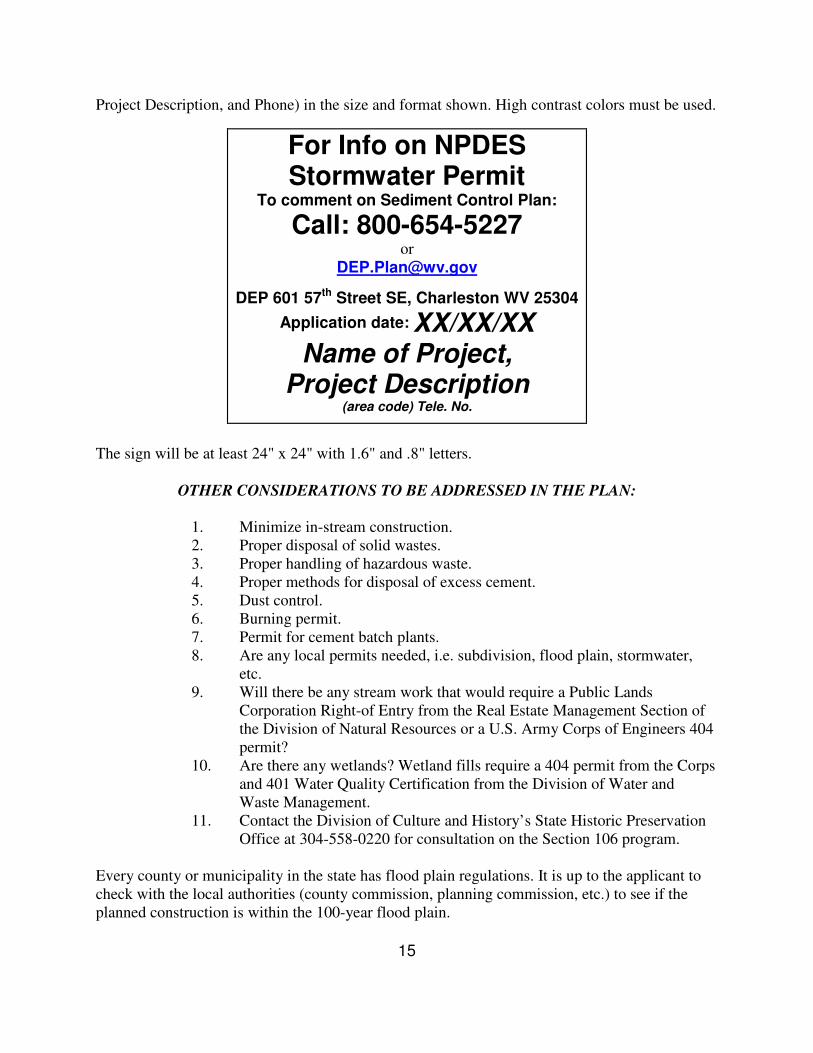
15
Project Description, and Phone) in the size and format shown. High contrast colors must be used. The sign will be at least 24" x 24" with 1.6" and .8" letters.
OTHER CONSIDERATIONS TO BE ADDRESSED IN THE PLAN:
1. Minimize in-stream construction. 2. Proper disposal of solid wastes. 3. Proper handling of hazardous waste. 4. Proper methods for disposal of excess cement. 5. Dust control. 6. Burning permit. 7. Permit for cement batch plants. 8. Are any local permits needed, i.e. subdivision, flood plain, stormwater,
etc. 9. Will there be any stream work that would require a Public Lands
Corporation Right-of Entry from the Real Estate Management Section of the Division of Natural Resources or a U.S. Army Corps of Engineers 404 permit?
10. Are there any wetlands? Wetland fills require a 404 permit from the Corps and 401 Water Quality Certification from the Division of Water and Waste Management.
11. Contact the Division of Culture and History’s State Historic Preservation Office at 304-558-0220 for consultation on the Section 106 program.
Every county or municipality in the state has flood plain regulations. It is up to the applicant to check with the local authorities (county commission, planning commission, etc.) to see if the planned construction is within the 100-year flood plain.
For Info on NPDES Stormwater Permit
To comment on Sediment Control Plan:
Call: 800-654-5227 or
DEP 601 57th Street SE, Charleston WV 25304
Application date: XX/XX/XX Name of Project,
Project Description (area code) Tele. No.

16
POLLUTION PREVENTION PLAN CHECKLIST
• Is the check made out to the WV Department of Environmental Protection?
• Is the application being sent to the correct address, DWWM, Construction Stormwater, 601 57th Street, SE, Charleston WV 25304?
• Is the plan signed by a responsible party such as a president, vice-president, secretary, treasurer or owner of the project? For public institutions, the plan should be signed by a person with similar duties, such as a director, chief, or a corresponding upper level management position. Local, lower level positions of statewide organizations are not allowed to sign the Site Registration Application Form.
• Are the correct number of copies of the Site Registration Applications being sent? See page two of the instructions above.
• Is a detailed sequence of construction events included that clearly explains when and where sediment controls will be installed? Is there a complete narrative?
• Install sediment control before initial clearing and grubbing. Do not remove sediment control until the contributing drainage is stabilized.
• Are standards and specifications for seeding and mulching, both permanent and temporary, included?
• Is silt fence installed in areas of concentrated flows? Do not use silt fence in areas of
concentrated flow. The minimum standard is a maximum of 110 feet of slope above the fence. Do not use silt fence to control runoff from slopes greater than 2 to 1. Use rock check dams or sediment traps in areas of concentrated flows. Is silt fence shown placed on the contour?
• Are all the hydrologic calculations for pre and post development storms and for stormwater facilities and sediment basins and traps included? Are the volume calculations included for the basins and traps? Dewatering time for basins calculated?
• Is stormwater routing clearly shown on the drawings?
• Are all waste and borrow sites included in the plans? Will there be a need for additional haul roads not shown in the plans?
No sediment-laden water will be allowed to leave the site without going through an
appropriate sediment trapping device.

17
Definitions of BMP Categories and Types
These definitions will help you decide which BMP category your BMP data fits into.
BMP Definition
Category A: Wet Ponds and Wetlands
Practices that have a combination of a permanent pool, extended detention or shallow wetland equivalent to the entire water quality storage volume. Practices that include significant shallow wetland areas to treat urban stormwater but often may also incorporate small permanent pools and/or extended detention storage. (MD 2000)
Wet pond A stormwater management pond designed to obtain runoff and always contains water. (Prince George’s LID Report)
Wet extended detention pond Combines the pollutant removal effectiveness of a permanent pool of water with the flow reduction capabilities of an extended storage volume. (http://www.deq.state.id.us/water/stormwater_catalog/ doc_bmp47.asp)
Multiple pond system A group of ponds that collectively treat the water quality volume. (New York Stormwater Management Design Manual)
"Pocket" pond A wetland that has such a small contributing drainage area that little or no baseflow is available to sustain water elevations during dry weather. Water elevations are highly influenced, and in some cases, maintained by a locally high water table. (Technical Note #77 from Watershed Protection Techniques. 2(2): 374-376)
Shallow wetland A wetland that provides water quality treatment entirely in a wet shallow marsh. (New York Stormwater Management Design Manual)
Extended detention wetland A wetland system that provides some fraction of the water quality volume by detaining storm flows above the mash surface. (New York Stormwater Management Design Manual)
Pond/wetland system A wetland system that provides a portion of the water quality volume in the permanent pool of a wet pond that precedes the marsh for a specified minimum detention time. (New York Stormwater Management Design Manual)
"Pocket" wetland A stormwater wetland design adapted for the treatment of runoff from small drainage areas (< 5 acres) and which has little or no baseflow available to maintain water elevations and relies on groundwater to maintain a permanent pool. (MD 2000)
Submerge gravel wetland One or more treatment cells that are filled with crushed rock designed to support wetland plants. Stormwater flows subsurface through the root zone of the constructed wetland where pollutant removal takes place. (http://www.georgiastormwater.com/vol2/3-3-5.pdf)
Constructed wetland Constructed wetlands are systems that perform a series of pollutant removal mechanisms including sedimentation, filtration, absorption, microbial decomposition and vegetative uptake to remove sediment, nutrients, oil and grease, bacteria and metals. Wetland systems reduce runoff velocity thereby promoting settling of solids. Plant uptake accounts for removal of dissolved constituents. In addition, plant material can serve as an effective filter medium and denitrification in the wetland can remove nitrogen. (EPA Handbook: Urban Runoff Pollution Prevention and Control Planning)
Retention pond (wet) Surface pond with a permanent pool.

18
Wetland basin with open water surfaces
Similar to retention ponds except that a significant portion (usually 50% or more) of the permanent pool volume is covered by emergent wetland vegetation. (www.purdue.edu)
Retention Basin Capture a volume and retain that volume until it is displaced in part or in total by the next runoff event. Maintains a significant permanent pool volume of water between runoff events. (EPA: http://www.epa.gov/ost/stormwater/usw_c.pdf)
Category B: Dry Detention, Hydrodynamic Structure
Practices used to moderate flows and remains dry between storm events.
Dry pond Designed to moderate influence on peak flows and drains completely between storm events. (www.deq.state.id.us/ water/stormwater_catalog/chapter5_5.asp)
Underground dry detention facility
Designed to dry out between storms and provides storage below ground in tanks and vaults. (www.deq.state.id.us/ water/stormwater_catalog/chapter5_5.asp)
Category C: Dry Extended Detention
A stormwater design feature that provides gradual release of volume of water in order to increase settling of pollutants and protects downstream channels from frequent storm events.
Dry extended detention pond (peak quantity control only)
Dry extended detention ponds (a.k.a. dry ponds, extended detention basins, detention ponds, extended detention ponds) are basins whose outlets are designed to detain the stormwater runoff from a water quality "storm" for some minimum duration (e.g., 24 hours) which allow sediment particles and associated pollutants to settle out. Unlike wet ponds, dry extended detention ponds do not have a permanent pool. However, dry extended detention ponds are often designed with small pools at the inlet and outlet of the pond, and can also be used to provide flood control by including additional detention storage above the extended detention level. (www.stormwatercenter.net)
Extended detention basin An impoundment that temporarily stores runoff for a specified period and discharges it through a hydraulic outlet structure to a downstream conveyance system. An extended detention basin is usually dry during non-rainfall periods. (VA DCR website)
Enhanced extended detention basin
An enhanced extended detention basin has a higher efficiency than an extended detention basin because it incorporates a shallow marsh in the bottom. The shallow marsh provides additional pollutant removal and helps to reduce the resuspension of settled pollutants by trapping them. (VA DCR website)
Group D: Infiltration Practices Practices that capture and temporarily store the water quality volume before allowing it to infiltrate into the soil. (MD 2000)
Infiltration Trench An excavated trench that has been back filled with stone to form a subsurface basin. Stormwater runoff is diverted into a trench and stored until it can be infiltrated into the soil. (Prince George’s, LID Report)
Infiltration Basin Relatively large, open depressions produced by either natural site topography or excavation. When runoff enters an infiltration basin, the water percolates through the bottom or the sides and the sediment is trapped in the basin. The soil where an infiltration basin is built must be permeable enough to provide adequate infiltration. Some pollutants other than sediment are also removed in infiltration basins. (epa.gov/owow/nps/education/runoff.html)
Porous Pavement Pavement that allows stormwater to infiltrate into underlying soils promoting pollutant treatment and recharge. (EPA LID Fact Sheet)

19
Category E: Filtering Practices Practices that capture and temporarily store the water quality volume and pass it through a filter bed.
Filtering and Open Channel Practices
Practices that capture and temporarily store the water quality volume and pass it through a filter bed of sand, organic matter, soil or other media are considered to be filtering practices. Filtered runoff may be collected and returned to the conveyance system. Vegetated open channels that are explicitly designed to capture and treat the full water quality volume within dry or wet cells formed by checkdams or other means. (MD 2000)
Surface sand filter Both the filter bed and the sediment chamber are above ground. The surface sand filter is designed as an off-line practice, where only the water quality volume is directed to the filter. (www.stormwatercenter.net)
Underground sand filter A modification of the surface sand filter, where all of the filter components are underground. An off-line system that receives only the smaller water quality events. (www.stormwatercenter.net)
Perimeter sand filter Includes the basic design elements of a sediment chamber and a filter bed. In this design, however, flow enters the system through grates, usually at the edge of a parking lot. The perimeter sand filter is the only filtering option that is on-line, with all flows entering the system, but larger events bypassing treatment by entering an overflow chamber. (www.stormwatercenter.net)
Organic media filter Essentially the same as surface filters, with the sand media replaced with or supplemented with another medium. The assumption is that these systems will have enhanced pollutant removal for many compounds due to the increased cation exchange capacity achieved by increasing the organic matter. (www.stormwatercenter.net)
Pocket sand filter Diverts runoff from the water quality volume into the filter by pipe where pretreatment is by means of concrete flow spreader, a grass filter strip and a plunge pool. The filter bed is comprised of a shallow basin containing the sand filter medium. The filter surface is a layer of soil and a grass cover. In order to avoid clogging the filter has a pea gravel "window” which directs runoff into the sand and a cleanout and observation well. (http://www.wcc.nrcs.usda.gov/watershed/UrbanBMPs/pdf/water/quali
ty/pocketsandfilter.pdf)
Bioretention areas (a.k.a. Rain Gardens)
Primarily for water quality control. These are planting areas installed in shallow basins in which the stormwater runoff is treated by filtering through the bed components, biological and biochemical reactions within the soil matrix and around the root zones of the plants and infiltration into the underlying soil strata (VA web site).
Swale In general a swale (grass channel, dry swale, wet swale, water quality swale) refers to a series of vegetated open channel management practices designed specifically to treat and attenuate stormwater runoff for a specified water quality volume. It is treated through filtering by the vegetation in the channel, filtering through a subsoil matrix, and/or infiltration into the underlying soils. (EPA Fact Sheet)
Dry Swale A type of grassed swale. Controls quality AND volume (Prince George’s LID). An open drainage channel explicitly designed to detain and promote the filtration of stormwater runoff through an underlying fabricated soil media. (MD 2000)

20
Infiltration Swale Planted areas designed specifically to accept runoff from impervious areas (i.e. parking lots) providing temporary storage and onsite infiltration. (http://www.metrocouncil.org/environment/Watershed/bmp/CH3_RPPI
mpParking.pdf)
Wet Swale (a.k.a. Water Quality Swale)
A type of grassed swale. Uses residence time and natural growth to reduce peak discharge and provide water quality treatment before discharge to a downstream location (Prince George’s LID). An open drainage channel or depression, explicitly designed to retain water or intercept groundwater for water quality treatment. (MD 2000)
Dry Wells Dry well – small excavated pit, backfilled with aggregate, usually pea gravel or stone. Function as infiltration systems used to control runoff from building rooftops (Prince George’s LID).
Category F: Roadway Systems (sheet flow to median)
Using a BMP to reduce the total area of impervious cover, thereby reducing the pollutant and sediment load in a given area.
Sheet flow discharge to stream buffers
Sheet flow is water flowing in a thin layer of the ground surface. Filter strips are a strip of permanent vegetation above ponds, diversions and other structures to retard the flow of runoff, causing deposition of transported material, thereby reducing sedimentation. (MD 2000)
Category G: Impervious Surface Reduction
Using a BMP to reduce the total area impervious area and therefore encouraging stormwater infiltration.
Natural area conservation Maintaining areas such as forests, grasslands and meadows that encourage stormwater infiltration.
Disconnection of rooftop runoff Disconnecting the rooftop drainage pipe and allowing it to infiltrate into the pervious surface thereby reducing the impervious area.
Disconnection of non-rooftop impervious area
Directing sheet flow from impervious surfaces, i.e. driveways and sidewalks, to pervious surfaces instead of stormwater drains.
Rain Barrels Rain barrels retain a predetermined volume of rooftop runoff (Prince George’s LID).
Green Roofs A multi-layer construction material consisting of a vegetative layer that effectively reduces urban stormwater runoff by reducing the percentage of impervious surfaces in urban areas. (EPA LID Fact Sheet)
Category H; Street Sweeping, Catch Basin Inserts
A variety of BMPs that provide stormwater treatment for trash, litter, coarse sediment, oil and other debris before proceeding through the stormwater system.
On-line storage in the storm drain network
A management system designed to control stormwater in the storm drain network. (MD 2000)
Catch basin inserts Small, passive, gravity-powered devices that are fitted below the grate of a drain inlet. Intercept and contain significant amounts of litter, vegetation, petroleum hydrocarbons and coarse sediments. (www.kristar.com)
Oil/grit separators Oil/grit separators – systems designed to remove trash, debris and some amount of sediment, oil and grease from stormwater runoff based on the principles of sedimentation for the grit and phase separation for the oil. (www.metrocouncil.org/environment/watershed/bmp/CH3_STDet OilGrit.pdf)
21
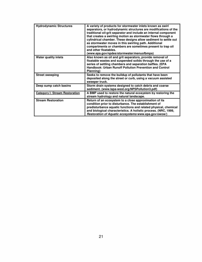
Hydrodynamic Structures A variety of products for stormwater inlets known as swirl separators, or hydrodynamic structures are modifications of the traditional oil-grit separator and include an internal component that creates a swirling motion as stormwater flows through a cylindrical chamber. These designs allow sediment to settle out as stormwater moves in this swirling path. Additional compartments or chambers are sometimes present to trap oil and other floatables. (www.epa.gov/npdes/stormwater/menuofbmps)
Water quality inlets Also known as oil and grit separators, provide removal of floatable wastes and suspended solids through the use of a series of settling chambers and separation baffles. (EPA Handbook: Urban Runoff Pollution Prevention and Control Planning)
Street sweeping Seeks to remove the buildup of pollutants that have been deposited along the street or curb, using a vacuum assisted sweeper truck.
Deep sump catch basins Storm drain systems designed to catch debris and coarse sediment. (www.lapa-west.org/NPSPollution3.pdf)
Category I: Stream Restoration A BMP used to restore the natural ecosystem by restoring the stream hydrology and natural landscape.
Stream Restoration Return of an ecosystem to a close approximation of its condition prior to disturbance. The establishment of predisturbance aquatic functions and related physical, chemical and biological characteristics. A holistic process. (NRC, 1999, Restoration of Aquatic ecosystems www.epa.gov/owow/)