Embed Size (px)
Citation preview

Instructions for Using the Interactive Map:
Snohomish County Planning and Development Services (PDS) is pleased to offer this interactive map to
our customers, partners, and stakeholders. The PDS Map Portal provides quick access to a wealth of
planning-related information for unincorporated Snohomish County and using Map Themes, navigate
through topics, such as Zoning, Future Land Use, Critical Area Regulations, Capital Facilities, and many
more. The PDS Map Portal also offers a variety of built in tools for further exploration of data layers, as
well as tools for searching, querying, creating, and editing features and annotation.
The Key Features for the PDS Map Portal are:
Search Parcels by Permit Number Tool
o This tool allows users to search parcels by specific permit within Snohomish County,
using the integration of records and data from Snohomish County PDS’s permit tracking
database.
Search Parcels by Permit Type Tool
o This tool allows users to robustly search parcels by permit subtypes, Amanda folder
types, permit status type and date ranges, using the integration of records and data
from Snohomish County PDS’s permit tracking database.
Search Sections(Township Section Ranges)
o This tool allows users to search by specific Township, Range or Section numbers within
Snohomish County
Map Themes
o Data layers are organized by Planning and Development oriented topics, such as Zoning,
Future Land Use, Critical Area Regulations, Capital Facilities and more.
Print Custom Maps
o This tool allows users to create their own customizable maps, using the numerous data
layers from the PDS Map Portal. Users can customize their layout template, output
format, resolution, map grids, scales as well as the ability to add a map name and
notes.
Global Search
o Enables users to search certain features within the application, such as Address, City,
and many more.
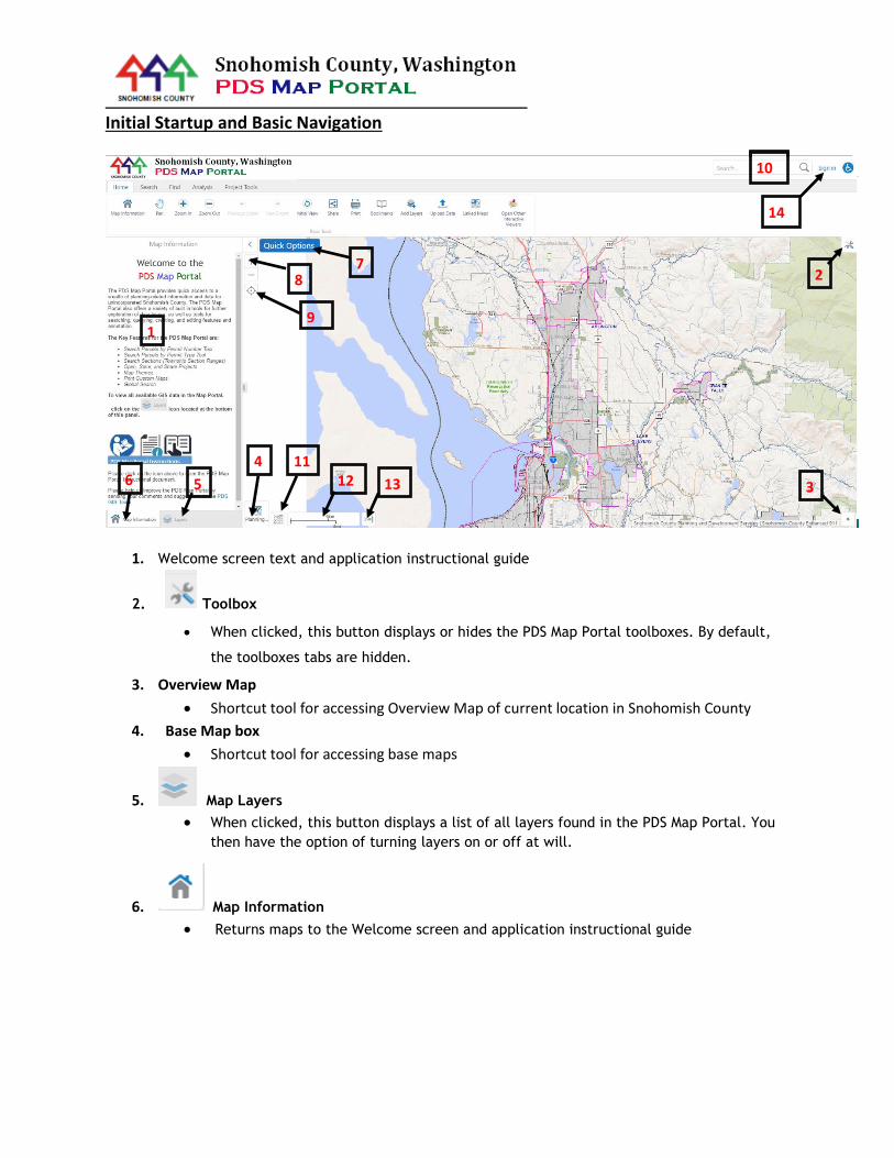
Initial Startup and Basic Navigation
1. Welcome screen text and application instructional guide
2. Toolbox
When clicked, this button displays or hides the PDS Map Portal toolboxes. By default,
the toolboxes tabs are hidden.
3. Overview Map
Shortcut tool for accessing Overview Map of current location in Snohomish County
4. Base Map box
Shortcut tool for accessing base maps
5. Map Layers
When clicked, this button displays a list of all layers found in the PDS Map Portal. You
then have the option of turning layers on or off at will.
6. Map Information
Returns maps to the Welcome screen and application instructional guide
1
2
11
6 5
4 13 14
12
3
7 8
9
10
15
1
2
10
6 5
4 12 13
11
3
7 8
9
14

7. Quick Options
List of application shortcuts within the PDS Map Portal, which include: i. Sign in (Snohomish County Employees Only feature)
ii. Open Project (Snohomish County Employees Only feature)
iii. Save Project (Snohomish County Employees Only feature)
iv. Save as Project (Snohomish County Employees Only feature)
v. View Map Information
vi. Find data on the map
vii. Change the visibility of layers on the map
viii. Return to the Initial Map View
ix. Bookmark current map extent
8. Zoom Tool
Tool used for zooming in and out in the Map App. If your computer mouse has a scroll
wheel, you can use this tool to accomplish the same thing.
9. Geolocation
Enables user to find current, track, or follow locations using GPS within the PDS Map
Portal
10. Global Search
The Global Search feature, located in the upper right hand corner, enables users to
search for certain features within the application.
11. X Y tool
Provides x, y coordinates for current map location (measured in feet) in the NAD83
Washington State Plane North FIPS 4601 coordinate system.
12. Scale Bar
Provides scale bar for map
13. Scale Ratio/input
Provides scale ratio as well as input for map
14. Sign In tool
If the user is a Snohomish County employee with a Snohomish County windows
credentials, the user will have the ability to sign into the PDS Map Portal and then have
the option to open, create and save versions of the PDS Map Portal for future use and
updates
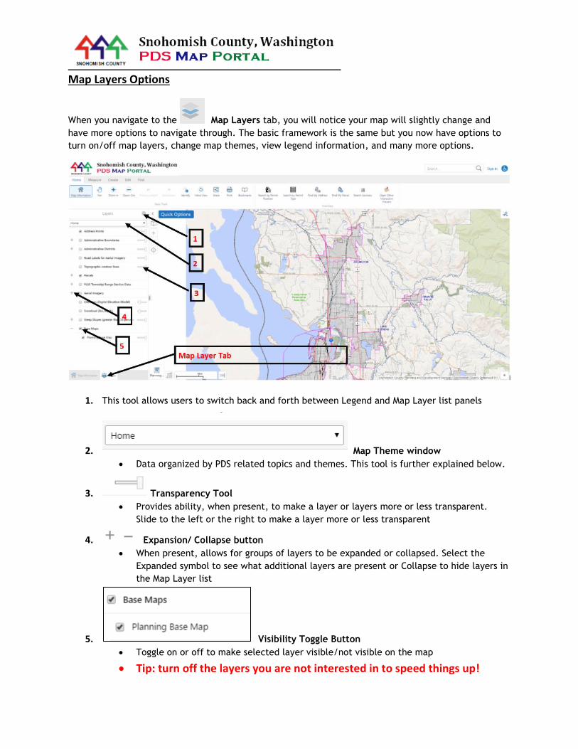
Map Layers Options
When you navigate to the Map Layers tab, you will notice your map will slightly change and
have more options to navigate through. The basic framework is the same but you now have options to
turn on/off map layers, change map themes, view legend information, and many more options.
1. This tool allows users to switch back and forth between Legend and Map Layer list panels
2. Map Theme window
Data organized by PDS related topics and themes. This tool is further explained below.
3. Transparency Tool
Provides ability, when present, to make a layer or layers more or less transparent.
Slide to the left or the right to make a layer more or less transparent
4. Expansion/ Collapse button
When present, allows for groups of layers to be expanded or collapsed. Select the
Expanded symbol to see what additional layers are present or Collapse to hide layers in
the Map Layer list
5. Visibility Toggle Button
Toggle on or off to make selected layer visible/not visible on the map
Tip: turn off the layers you are not interested in to speed things up!
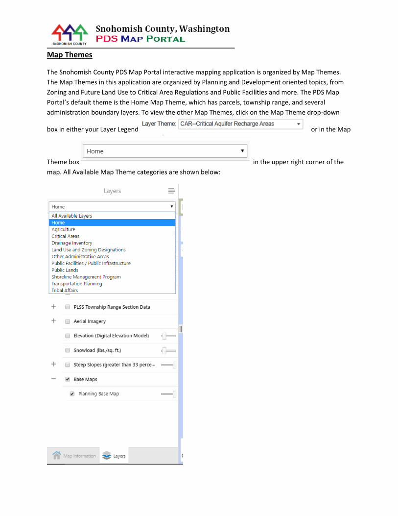
Map Themes
The Snohomish County PDS Map Portal interactive mapping application is organized by Map Themes.
The Map Themes in this application are organized by Planning and Development oriented topics, from
Zoning and Future Land Use to Critical Area Regulations and Public Facilities and more. The PDS Map
Portal’s default theme is the Home Map Theme, which has parcels, township range, and several
administration boundary layers. To view the other Map Themes, click on the Map Theme drop-down
box in either your Layer Legend or in the Map
Theme box in the upper right corner of the
map. All Available Map Theme categories are shown below:
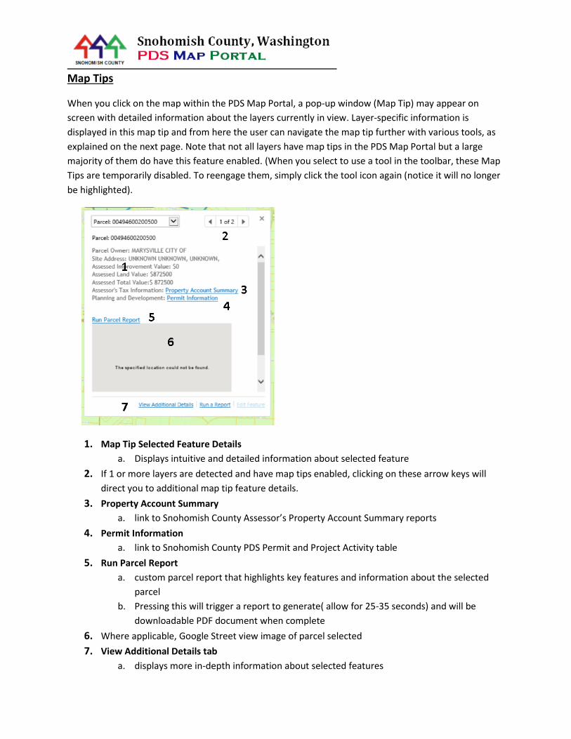
Map Tips
When you click on the map within the PDS Map Portal, a pop-up window (Map Tip) may appear on
screen with detailed information about the layers currently in view. Layer-specific information is
displayed in this map tip and from here the user can navigate the map tip further with various tools, as
explained on the next page. Note that not all layers have map tips in the PDS Map Portal but a large
majority of them do have this feature enabled. (When you select to use a tool in the toolbar, these Map
Tips are temporarily disabled. To reengage them, simply click the tool icon again (notice it will no longer
be highlighted).
1. Map Tip Selected Feature Details
a. Displays intuitive and detailed information about selected feature
2. If 1 or more layers are detected and have map tips enabled, clicking on these arrow keys will
direct you to additional map tip feature details.
3. Property Account Summary
a. link to Snohomish County Assessor’s Property Account Summary reports
4. Permit Information
a. link to Snohomish County PDS Permit and Project Activity table
5. Run Parcel Report
a. custom parcel report that highlights key features and information about the selected
parcel
b. Pressing this will trigger a report to generate( allow for 25-35 seconds) and will be
downloadable PDF document when complete
6. Where applicable, Google Street view image of parcel selected
7. View Additional Details tab
a. displays more in-depth information about selected features

ADVANCED TOOLS
When the PDS Map Portal first opens, the Toolbar should open by default. At any time, you can
open/close the Toolbar menu by hitting the Toolbox button. Listed Below are the many tools,
functions and options found inside the Toolbar menu inside the PDS Map Portal
Home Toolbox
Basic Tools Tab: basic tools for navigating and interacting with the PDS Map Portal
Identify
o Identifies any layers when you click on and gives you information on selected feature as
well as found results for that particular area
Initial View
o Returns PDS Map Portal to initial, zoomed out county scale
Share
o Share your current session of the PDS Map Portal via external sites such as Facebook,
Twitter, LinkedIn, Google+ and email. When you Share your PDS Map Portal session, it
will transmit your specific session settings (i.e. what layers you have turned on, layer
visibility, scale, transparency settings, and theme choice) to any of those platforms;
however, user created drawings and text will not be transmitted via the Share button.
o This tools allows users to create their own customized map in the PDS Map Portal. User
can select
Print dimensions
Output format
Resolution
Presence of Grid lines
Map Scale
Map Name
Map Notes
Bookmarks
o This tool allows users to load “bookmarked” views of locations in the county. Scroll to
the bottom of these pre-created bookmark views and the user will have the option to
save a custom bookmark by using the "Bookmark Current Extent" option.
Add Layers
o Add Layers from ArcGIS online or other Snohomish County Map Service. Use the search
function in this tool to see what layers can be brought into a PDS Map Portal session
Upload Data
o Use this tool to add data to the PDS Map portal. The tools supports file types such as
csv, .xlsx, .kml, .shp, .gpx, or a .zip containing a FileGDB or shapefiles. Choose files to
upload from your computer, and they will become temporarily available to your PDS
Map Portal session
Linked Maps
o This tool allows you to open and display Google Street View and Bing Maps directly into
your PDS Map Portal. The tool will place a blue marker in the center of your PDS Map
Portal viewer that acts as the view point for Google Street View and Bing Maps. The
tools synchs your movement and navigation around in the PDS Map Portal section of the
viewer and applies it to the Google Street View and Bing Maps windows.
Open other Interactive Maps
o This tool displays all other interactive viewers that were produced or related to
Snohomish County
Currently, this includes links to the:
PDS iGallery
PDS Map Portal and Map Themes
PDS Active Project/Permits Map (coming winter/spring 2017)
River Atlas Map (open with Internet Explorer internet browser)
Stillaguamish River Clean Water District Map (open with Internet
Explorer internet browser)
Surface Water Management Drainage Inventory Map
SR 530 Oso Slide Map (open with Internet Explorer internet browser)

Search Toolbox
Search by Permit Number
o Search by valid permit numbers and return results for property/properties associated
with those permits
Search by Permit Type
o Search for properties by Permit Type, Subtypes, Status and range of dates.
Find My Address
o This tool helps users zoom to and locate their address within the PDS Map Portal. The
user needs to enter a valid street address and then press the “search” button; once
this occurs, the map will then return results for address that best match your search
criteria within the viewer.
Find My Parcel
o This tool helps users zoom to and locate their parcel within the map app. The user
needs to enter a valid parcel id number (PID) and then press the “search” button; once
this occurs, the map will then automatically pan to that particular parcel within the
viewer.
Search Sections(Township Section Ranges)
o Search by Townships, Range, and Section numbers
Open other Interactive Maps
o This tool displays all other interactive viewers that were produced or related to
Snohomish County.
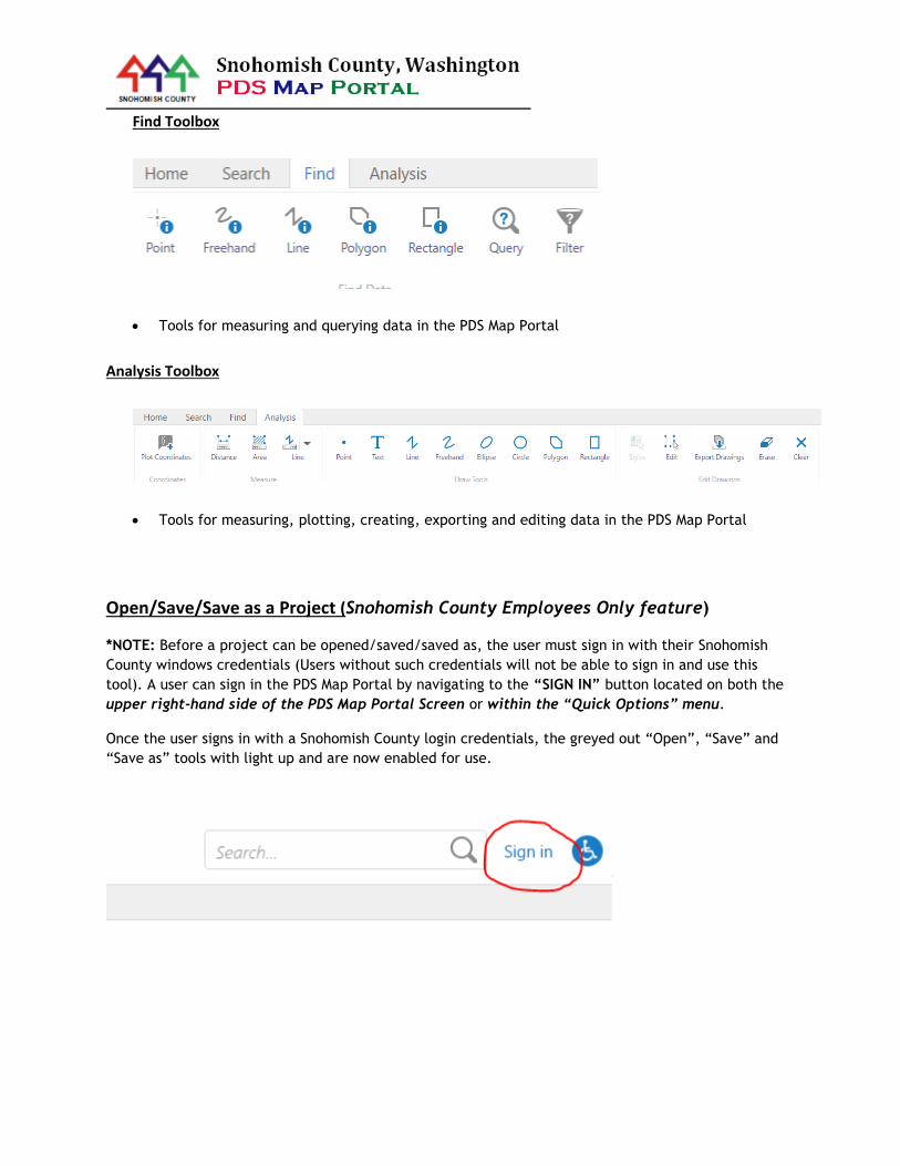
Find Toolbox
Tools for measuring and querying data in the PDS Map Portal
Analysis Toolbox
Tools for measuring, plotting, creating, exporting and editing data in the PDS Map Portal
Open/Save/Save as a Project (Snohomish County Employees Only feature)
*NOTE: Before a project can be opened/saved/saved as, the user must sign in with their Snohomish
County windows credentials (Users without such credentials will not be able to sign in and use this
tool). A user can sign in the PDS Map Portal by navigating to the “SIGN IN” button located on both the
upper right-hand side of the PDS Map Portal Screen or within the “Quick Options” menu.
Once the user signs in with a Snohomish County login credentials, the greyed out “Open”, “Save” and
“Save as” tools with light up and are now enabled for use.

To open/save/save as a Project, navigate to the either the “Quick Options” menu or the “Project
Tools” tab in the toolbar

Open
Open a Project feature, where you can choose to open a previously saved project from
the last saved state
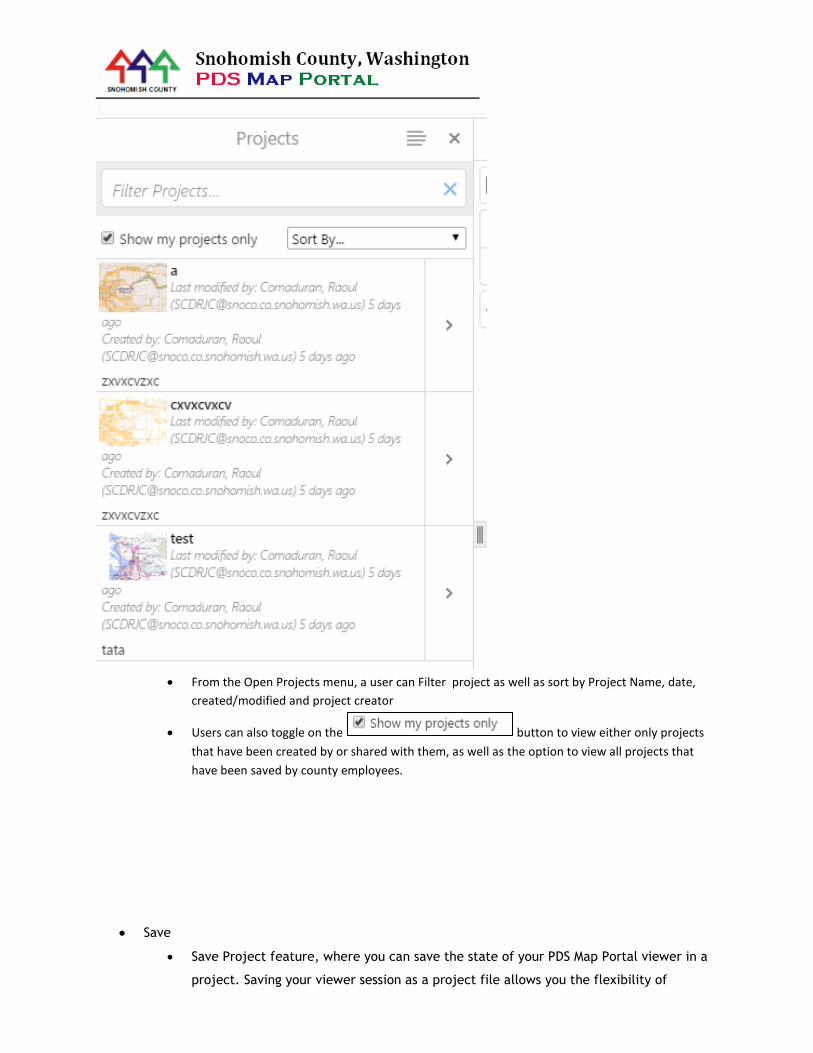
From the Open Projects menu, a user can Filter project as well as sort by Project Name, date,
created/modified and project creator
Users can also toggle on the button to view either only projects
that have been created by or shared with them, as well as the option to view all projects that
have been saved by county employees.
Save
Save Project feature, where you can save the state of your PDS Map Portal viewer in a
project. Saving your viewer session as a project file allows you the flexibility of

customizing your viewer the way you want (turn on only certain layers, zoomed into
particular areas, adding drawings, text, custom shapefiles, or importing spreadsheets)
and then returning to it later for further use and customization. Create a unique
project name and a brief description and then press Save. Your project is now saved for
future use and further customization!
Save as
Save as Project feature, where you can save the state of your PDS Map Portal viewer in
a new project.
Once a project has been saved or saved as, this menu will pop up:

The “Share” button allows you to share your project to other Snohomish County staff
while restricting them from users who don’t need to see your project
This menu will then display, listing several options for how to share or restrict access
to your project
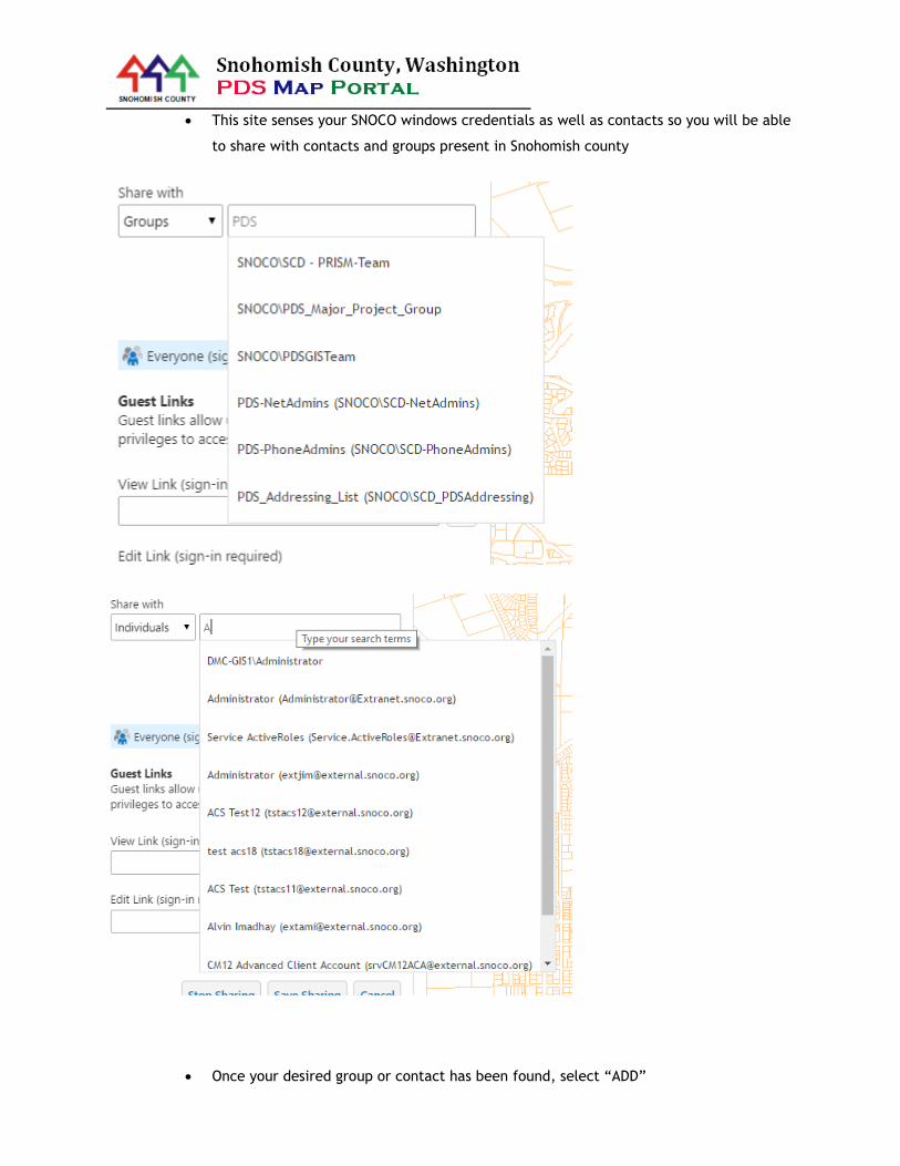
This site senses your SNOCO windows credentials as well as contacts so you will be able
to share with contacts and groups present in Snohomish county
Once your desired group or contact has been found, select “ADD”
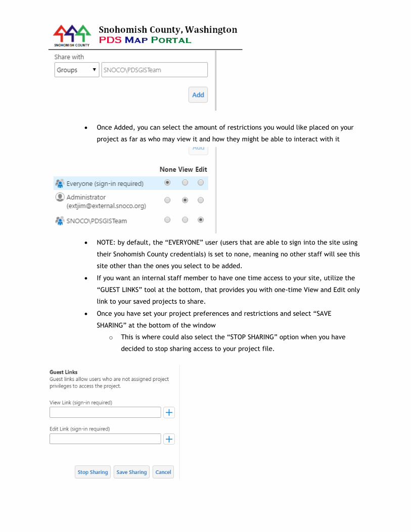
Once Added, you can select the amount of restrictions you would like placed on your
project as far as who may view it and how they might be able to interact with it
NOTE: by default, the “EVERYONE” user (users that are able to sign into the site using
their Snohomish County credentials) is set to none, meaning no other staff will see this
site other than the ones you select to be added.
If you want an internal staff member to have one time access to your site, utilize the
“GUEST LINKS” tool at the bottom, that provides you with one-time View and Edit only
link to your saved projects to share.
Once you have set your project preferences and restrictions and select “SAVE
SHARING” at the bottom of the window
o This is where could also select the “STOP SHARING” option when you have
decided to stop sharing access to your project file.