Embed Size (px)
Citation preview
NOT FOR PUBLICATIONWITHOUT WRITER’S CONSENT
INSTITUTE OF CURRENT WORLD AFFAIRSGSH-14 June 1981
FORESTS & FORESTRY IN PANAMA
by
Dr. Gary S. HartshornForest & Man Fellow
As part of a seven-person team conducting a country environmental profilefor AID, I spent four weeks in Panama in May, 1980, analyzing the forestrysector. In this abridged version of my report to AID I offer an overview ofthe forest resource base, analyze the management of the forest resources andaddress the major fo.restry problems.
SUMMARY
Of the twelve Holdridge Life Zones in Panama, more than 75% of the countryoccurs in just four Life Zones- Tropical Moist, Wet, Premontane Wet and Rain.The cuipo tree dominates more than i0,000 km2 of eastern Panama. Other importantforest types are dominated by single specie.s such as cativo along the Rio Chu-cunaque, orey around the Laguna de Chiriqui and mangroves on coastal deltas.Little is known about the forests of the wet Caribbean lowlands or the mountainoussuperhumid areas.
Panama’s forests decreased from 70% of the country in 1947 to 50% in 1974.Current rough estimates of forest cover are 40-45%. Estimates of importantforest types vary considerably, ranging from 4,200 to 9,650 m2 of cativo forestsand 1,990 to 5,056 km2 of mangroves. Advancing agricultural frontiers are de-stroying vast areas of forest along the Bayano-Yaviza highway, in the Caribbeanlowlands of the central region, and on the upper Pacific slopes of the westerncordillera.
The timber industry is based on only a handful of species, with cativo con-tributing approximately 50% of the logs. Panama’s forests also make significantindirect contributions such as the mangrove breeding grounds of the white shrimpand the hydrologic regula.tory functions of natural forests in mountainous watersheds.
The amount of deforested and degraded lands indicates that the agriculturalconquests of the Darien and the Caribbean lowlands are doomed because most ofthe soils cannot sustain permanent agriculture. Reforestation totaling 4,500 hais a mere token compared to annual deforestation exceeding 50,000 ha. RENAREis involved with three ambitious reforestation projects totaling 38,500 ha overa five year period.
Problems involving the forestry sector include indiscriminate agriculturalcolonization, weak institutional leadership, the poorly conceived forest conces-sion system, complete absence of silviculture and forest management, lack of up-to-date information on forest utilization and conversion, poor timber utilization,and only token efforts to rehabilitate degraded soils.
Gary Hartshorn is a Forest & Man Fellow writing on mans relationwith the forest resources of tropical America.
GSH-14 2
i. FOREST RESOURCES
1.A. General Descripti.on
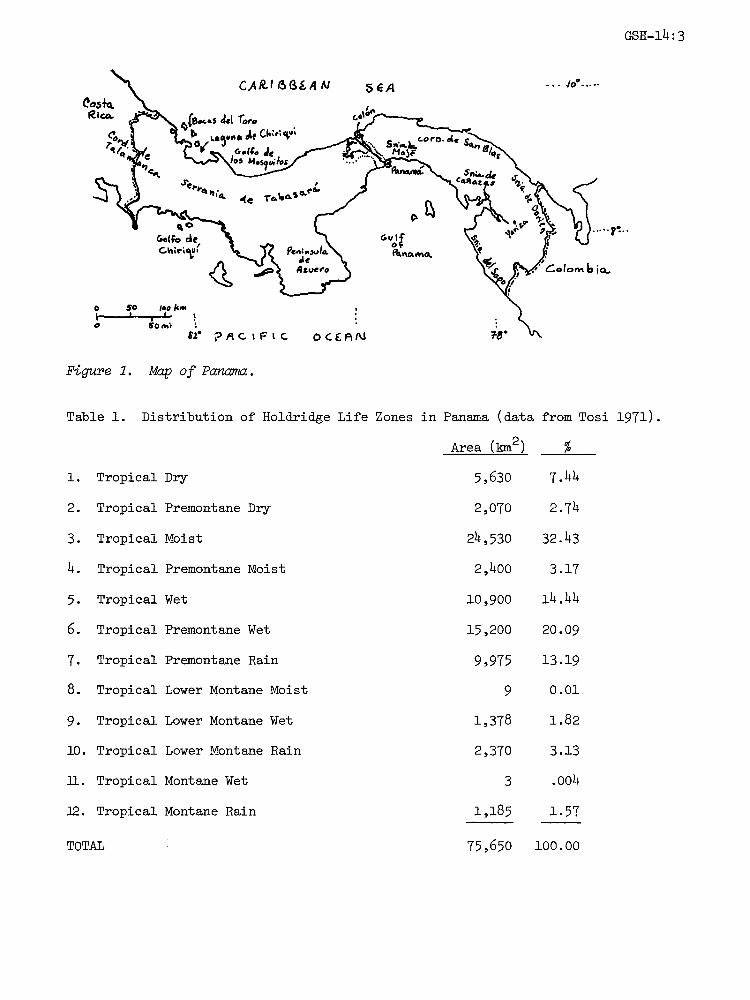
The Republic of Panama (77,082 km2 27,750 square miles) straddles thenarrow isthmus that unites North and South America. In spite of the north-southland connection, Panama has an undulating east-west configuration (Fig. I) thatresults in the Caribbean end of the Panama Canal being farther west than thePacific end. The Pacific coastline (1,634 km) is more than twice the length ofthe Atlantic coastline (788 kin). The South Carolina-sized country has geographicalcoordinates of 7 12’ 9 38’ North and 77 09’ 83 03’ West.
The 1980 population is estimated to be almost two million (26/km2). Althoughslightly more than half the population lives in urban centers, approximately 30%of the national population is economically active. The annual rate of populationincrease averaged 3.1% between 1970 and 1976, thus nearly half of the Panamanianpopulation is less than 15 years old.
Western Panama is dominated by the easterly extension of the Cordillera deTalamanca from Costa Rica and the appendage-like Azuero peninsula. The centrallowlands are bisected by the Canal. Eastern Panama is framed by a series ofcoastal ranges" Serrania de San Blas and Serrania del Darmen very close to theCaribbean coast; Serrania de Maj@ and Serrania del Sapo breached by the largeGolfo de San Miguel; and the Serrania de Pirre near the Colombian border.
Holdridge Life Zones (described in GSH-3) in the extensive lowlands of Panamaare determined primarily by rainfall regimes. The movement of tropical air massesfrom the Pacific and subtropical air masses from the Caribbean produce two dis-tinct rainfall patterns" (i) The Pacific rainfall regime consists of a monsoon-type alternation of a seven month rainy season with a five month dry season. Thedominance of northeasterly tradewinds from December to March in combination Wihthe mountainous backbone of Panama produces a pronounced rainshadow effect through-out most of the Pacific lowlands. The severity of the rainless season is greatlystrengthened by the drying effect of the moistureless winds descending over thehot lowlands. The mid-elevation rainy areas in eastern Panama (Serranias de Majand Pirre and Sierra de Jungurud6) are in part due to orographic lifting ofmoisture-laden southwesterly tradewinds during Junel to August and greatly weakenednortheasterly tradewinds during December to March. These differences from westernPanama produce a more intense rainy season and a much weaker "dry" season near theColombian border.
(2) The narrow Caribbean slope and lowlands have a distinct regime of tworainfall maxima and two minima; the former in June-July and November-Decemberand the less rainy periods in September-0ctober and February-March. The short"dry" seasons have sufficient rain so that effectively dry periods stressful tonatural vegetation seldom occur.
Twelve Holdridge Life Zones occur in Panama (Table i), with four Life Zonescovering more than 75% of the country (Tosi 1971). Tropical Moist Life Zoneincludes most of the Pacific lowlands, extending from the Costa Rican border almostto the Colombian border. Only in the low central region does the Tropical MoistLife Zone etend across the isthmus to the Caribbean coast. Tropical Moist LifeZone also occurs as coastal bands in San Blas and around the Laguna de Chmrmqul(Bocas del Toro province).
GSH-4"
Figure . Map of Panama.
Table i. Distribution of Holdridge Life Zones in Panama (data from Tosi 1971).
Area (kin2) %
i. Tropical Dry 5,630 7.44
2. Tropical Premontane Dry 2,070 2.74
3. Tropical Moist 24,530 32.43
4. Tropical Premontane Moist 2,400 3.17
5. Tropical Wet i0,900 14.44
6. Tropical Premontane Wet 15,200 20.09
7. Tropical Premontane Rain 9,975 13.19
8. Tropical Lower Montane Moist 9 0.01
9. Tropical Lower Montane Wet 1,378 1.82
I0. Tropical Lower Montane Rain 2,370 3.13
iI. Tropical Montane Wet 3 .004
12. Tropical Montane Rain 1,185 1.57
TOTAL 75,650 i00. O0
Tropical Wet and Premontane Wet Life Zones are usually found at elevationshigher than Tropical Moist, or in wetter coastal areas. The most extensive areaof Tropical Wet Life Zone occurs in the Caribbean lowlands of the central region.Premontane Rain Life Zone occurs all along the western cordillera, on the Serra-nias del Dari@n, Pirre, Jungurad6, and Maj@, plus a few other outliers on theAzuero Peninsula and highest parts of the Lago de Alajuela watershed.
The driest areas (Tropical Dry and Premontane Dry Life Zones) occur in abroad arc bordering the Bahia de Parrita; small outliers also occur east ofPanama City and on Punta Garachne. These dry areas are apparently related tonearby upwelling of cold water.
I.B. Major Forest Typ.es
Cuipo-dominated forests (Fig. 2a) cover about 10,000 km2 of the TropicalMoist lowlands in the eastern region of Panama. Although many other tree speciesare associated with cuipo (Cavanillesia platanifolia, Bombacaceae), it is thehuge and abundant cuipo that gives such a distinctive aspect to the Darien low-lands. Large cuipo trees (Fig. 2b) may reach 40 m in height on a bole 2 m indiameter with a disproportionately small crown towering over other tree species.Several studies indicate cuipo occupies 39-60% of the timber volume (Donaldson1963; Golley et al. 1975; Falla 1978a). The exceptional size and abundance ofcuipo has attracted numerous attempts to find commercial uses for its wood.Cuipo wood is very light like balsa, but unusually weak. L. R. Holdridge likenscuipo to an overgrown vegetable. Detailed tests of cuipo wood for a variety ofproducts, including paper and fiberboard, have been unsuccessful (Rankin 1963).It should be tested for cattle fodder.
Cativo forests are pure or nearly pure stands of Prioria copaifera (Caesal-piniaceae) that occur on alluvial flats inundated occasionally with fresh water,but with adequately-drained soils. Cativo forests occur most frequently alongmajor rivers, such as those feeding into the Golfo de San Miguel. Lamb (1953)reported pure cativo stands on the banks of the Ro Balsas. More recent studiesalong the Ro Chucunaque indicate cativo dominated forests extend about 1 kmto each side of the river (Donaldson 1963; Anonymous 1978). Cativo also occursin mixed forests on better drained soils farther from rivers, as well as in theMora oleifera forests (Fig. 3 inundated daily by brackish water. Cativo forestsoccur in the Bocas del Toro lowlands and are also reported to occupy 4,000 haon Isla de Coiba (Falla 1978a).
Mangrove forests occur on both coasts of Panama, but are much more extensiveon the Pacific estuarine deltas due to the appreciably greater tidal flux on thePacific coast than in the Caribbean. The red mangroves (Rhizophora brevistylaand R. mangle, Rhizophoraceae) are overwhelming dominants of the mangrove forests,generally forming pure stands. The black mangrove (Avicennia germinans, Avicen-niaceae) andPelliciera, rhizophorae (Theaceae) are occasional tree associates inthe mangrove forests.
Orey forms pure stands in brackish swamps around the Laguna de Chiriqui inBocas del Toro province. These forests of orey (Campnosperma panamensis, Anacar-diaceae) probably have the highest stocking of timber known in the tropics, withaverage volumes of 382 m3/ha for boles greater than 40 cm in diameter and 716 m3/hafor all boleS, larger than l0 cm in diameter (Falla 1978a) Such impressive vol-umes of orey timber and its fiber suitability offer considerable potential fora pulp and paper industry (Holdridge et al. 1958).

Figure 2. (a) Cuipo-dominated forest southeast of the Bayano hydroelectric re-servoir. Note the clearings and logging road at lower right. (b) Gary at thebase of a giant cuipo tree in the Darien.

Figure 3. Mora (with sinewy buttresses) and cativo flooded occasionally withbrackish water near the San Miguel Gulf in the Darien. Left to Right" EdgarPea, Doug Pool, and Dave Janos.
A forest inventory of the Donoso district (Tropical Wet Life Zone) of thenorthern central region found adequate quantities of excellent timber treessuch as Dialyantera otoba and V%roZa spp. (Myristicaceae), Capa u%anen88(Meliaceae), Minquartia uianensi8 Olacaceae Aspidosperma mealocarpon(Apocynaceae) and Sacoglotti8 sp. (Humiriaceae).
The remaining forests of Panama, especially in the superhumid mountainousregions, are very poorly known. Except for the above-mentioned Donoso district,even the tropical wet lowlands along the Caribbean coast from Bocas del Toro toSan Blas are also poorly known. Tropical oaks of several species (@ureu8 spp.Fagaceae) are conspicuous of Lower Montane Wet and Rain Life Zones in thewestern cordillera. The Montane Rain Life Zone on Volcan Bar is dominated byhuge oaks (@. costaricensi8).
1.C Statu of Forests
At the itime of Spanish exploration of the Pacific lowlands of Panama in theearly 1500’s, a considerable indigenous population practiced shifting cultivationover extensive areas extending from eastern Darien as far west as present-day
Santiago (Sauer 1966). Corn was the principal crop grown by the Indians. Despitesubstantial differences in the subjective estimates sent to the Spanish Crown asto the size of the indigenous populations and the amounts of land under cultivation,it is widely accepted that fields and young secondary vegetation were far moreprevalent than undisturbed forest in the Pacific lowlands of eastern and centralPanama. The striking present-day (modern) dominance of these regions by cuipohas led some authors (e.g. Budowski 1965; Bennett 1968) to attribute cuipo’s suc-cess to large scale abandonment of land following decimation of the indigenouspopulation by the Spanish conquest. This interpretation claims the cuipo-dominatedforests are nearly 500 year-old-secondary forests; however, this is not supportedby recent studies of tropical forest dynamics nor by the regeneration potentialof cuipo (see Hartshorn 1978, for a more complete review).
Standley’s (1928) remarks about collecting in good "jungle" near Chorreraindicate that it is safe to assume that practically all of Panama was clothed inforest in the 17th and 18th centuries. Even the dry areas in the central regionshould have supported forests, for I have found no evidence in the literaturefor the occurrence of extensive natural savannas in Panama.
The earliest estimates of forest cover in Panama (Table 2) indicate thepaucity of forests in Cocl, Herrera and Los Santos provinces more than 30 yearsago. Garver (1947) estimated 70% of the country (not including the Canal Zone)to be in forest.
Falla (1978a) reports country-wide estimates of forest cover between 1950and 1974 (Table 3). The 1970 data are considered to be the most accurate becausethey are derived from country-wide forest inventories carried out by FAO in 1970and 1971. Falla’s 1974 estimate was derived by adjusting forest boundaries ob-served during aerial reconnaissance flights. The data in Table 3 yield annualdeforestation rates ranging between 0.5 and 1.0%, yet Falla (1978b) reports theagricultural frontier advanced 2.7% per year during the early 1970’s. It wasimpossible to verify either figure; however, since the agricultural frontier ad-vances at the expense of forests in Panama, it seems the latter figure may becloser to reality. Projection of an intermediate per annum rate of deforestationat 1.5% from the 1970 estimate yields 29,254 km2 or 38% of the country with forestcover in 1980. RENARE (National Directorate for Renewable Natural Resources)and FAO (Food and Agricultural Organization of the United Nations) foresters thinkthe actual forest cover is around 45% of the country. It is instructive to note
thatthe two most completely forested provinces o Panama (Bocas del Toro andDarien) have a combined surface area of 25,889 km or 34% of the country.
The uncertain status of Panama’s forests is further exemplified by the con-siderable differences in the estimates of cativo, orey and mangrove forests inPanama (Table 4). Falla’s estimate of 965 km2 of cativo forests for the entirecountry seems too high, since the cativo forests in Bocas del Toro and on Islade Coiba are minor in comparison with Dari@n. No explanation is given for thegrossly different estimates of mangrove forests given by Falla (1978a,b).
Field observations by both land and low-level aerial overflights indicateseveral active fronts of deforestation. In the Dari@n, agriculturalists continueto advance up the principal valleys and lower slopes (e.g. Rios Samba, Balsas,Tuira and Sabanas). Large-scale clearing i,s occurring along the entire lengthof the Interamerican Highway between Bayano and Yaviza. Even the steep slopeson the northern flanks of the Serrania de Maj@ are being rapidly deforested (Fig.2a). Several foci of deforestation activities occur in the coastal hills from
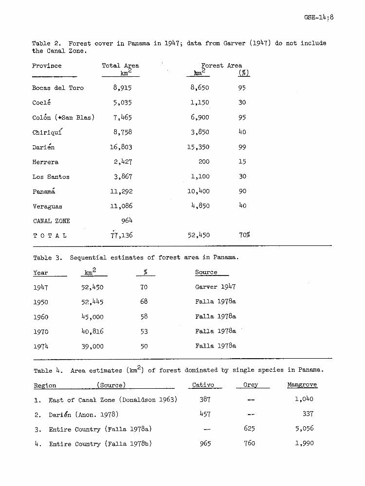
Table 2. Forest cover in Panama in 1947; data from Garver (1947) do not includethe Canal Zone.’
Province Total Areakm2
Forest Areakm:t2 (%)
Bocas del Toro 8,915 8,650 95
Cocl 5,035 1,150 30
Col6n (+San Blas) 7,465 6,900 95
Chiriqui" 8,758 3,850 40
Darlen 16,803 15,350 99
Herrera 2,427 200 15
Los Santos 3,867 i,i00 30
Panam i1,292 i0,400 90
Veraguas ii,086 4,850 40
CANAL ZONE 964
T 0 T A L 77,136 52,450 70%
Table 3. Sequential estimates of forest area in Panama.
Year km2 % Source
1947 52,450 70 Garver 1947
1950 52,445 68 Falla 1978a
1960 45,000 58 Falla 1978a
1970 40,816 53 Falla 1978a
1974 39,000 50 Falla 1978a
Table 4. Area estimates (km2) of forest dominated by single species in Panama.
Region (Source) Cativo Ore.y.. Mangrove
1. East of Canal Zone (Donaldson 1963) 387 1,o4o
2. Darien (Anon. 1978) 457 337
3. Entire Country (Falla 1978a) 625 5,056
4. Entire Country (Falla 1978b) 965 760 1,99o
GSH-14:9
the Golfo de San Blas west to Portobelo. Probably the most aggressive deforest-ation is occurring in a large area of Caribbean lowlands extending from the CanalZone southwest to Coclesito. The rolling coastal hills are being completelydenuded of forest from the Ro Lagarto to Punta Lim6n near Cocl@ del Norte. Theremaining forests south of this area are being severely squeezed by aggressivedeforestation radiating from Coclesito. Forest cutting even extends over thecontinental divide between Cerro Flores and Cerro Colorado. Appreciable slash-and-burn agriculture is claiming forests in the lower valleys and slopes of theRios Teribe and Changuinola in Bocas del Toro province.
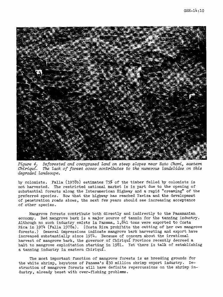
The Panamanian predilection for fire has had and continues to have disastrousconsequences for forest resources. The impoverishment and meager productivity ofthe Pacific lowlands of the central region are largely due to loss of trees throughrepetitive burning. Deliberate fires not only consume the felled trees, but oftenpenetrate adjoining forest and kill many more standing trees. With annual burningit is no surprise so little forest remains on the Pacific side of Western Panama(Fig. 4). Between San Felix and Hato Chami, 15-20% of the slopes were burned in1980. A wild fire also destroyed huge areas of forest on the southwestern flanksof Volcan Bar during the 1980 dry season.I.D. Direct Economic Role of Forests
Forests not only are the source of many indirect benefits such as watershedprotection, nutrient conservation, habitat preservation, biotic diversity, etc.,but also provide direct contributions to the Panamanian economy, estimated byFalla (1978a) at 2.0-2.2% of GNP. Timber, of course, is the primary forestproduct. Between 1965 and 1975 forest exploitation produced an annual averageof 225,000 m of logs valued at $3.18 million (Falla 1978a). Seventy-five percentof the logs went into sawn lumber and the remainder for plywood. The constructionindustry utilizes 65-85% of the sawn lumber. The national wood market grew at anannual rate of 4.6% between 1965 and 1975.
From 1960 to 1975 cativo supplied roughly 50% of the logs to the nationalmarket, with about 75% of the cativo logs coming from the Darlen. Cativo isused primarily as core stock for plywood and to a lesser extent as face veneerand form lumber. Quality woods such as caoba (mahogany, SwetenaMeliaceae) and cedro amargo (Spanish cedar, CeSreZa mx%cana, Meliaceae) havediminished greatly in quantity from their post World War II importance to wherethey provided only 10% of the timber used in 1974. According to Falla (1978a)94% of the logs marketed in 1976 were supplied by only five species: cativo,espav (Anacardium excelsum, Anacardiaceae), amargo amargo (Vatairea sp., Fabaceae),cedro espino (Bombacopsis quinatum, Bombacaceae) and zapatero (Hieronyma oblonga,Euphorbiaceae). Espave, amargo amargo and cedro espino are components of thecuipo forest in the eastern region. Zapatero comes from the tropical wet forestsof the northern central region.
Garver (1947) lists 63 saw timber species. Twenty years later only 30species were used (Falla 1978b). Although FAO identified 300 potentially commer-cial timber species in Panama, the national market accepts only 50 species (Anon.1979). The dominance of the national market by so few species means logging op-erations are very costly and inefficient. Cons.iderable quantities of good woodare bypassed in the logging of a few species. This would be acceptable silvi-culturally if the forests were controlled, protected and managed for a sustainedyield of timber. Advance of the agricultural frontier, however, is an importantsource of timber, thus considerable Volumes of non-harvested timber are burned
GSH-14
Figure 4. Deforested and overgrazed land on steep slopes near Hato ahami, easternChtrqu. The lack of forest cover contributes to the numerous landslides on thisdegraded landscape.
by colonists. Falla (1978b) estimates 75% of the timber felled by colonists isnot harvested. The restricted national market is in part due to the opening ofsubstantial forests along the Interamerican Highway and a rapid "creaming" of thepreferred species. Now that the highway has reached Yaviza and the developmentof penetration roads slows, the next few years should see increasing acceptanceof other species.
Mangrove forests contribute both directly and indirectly to the Panamanianeconomy. Red mangrove bark is a major sourCe of tannin for the tanning industry.Although no such industry exists in Panama, 1,841 tons were exported to CostaRica in 1974 (Falla 1978a). (Costa Rica prohibits the cutting of her own mangroveforests.) General impressions indicate mangrove bark harvesting and export haveincreased substantially since 1974. Because of concern about the irrationalharvest of mangrove bark, the governor of Chmrmqum Province recently decreed ahalt to mangrove exploitation starting in 1981. Yet there is talk of establishinga tanning industry in eastern Chiriqu.
The most important function of mangrove forests is as breeding grounds forthe white shrimp, keystone of Panama’s $30 million shrimp export industry. De-struction of mangrove forests will have definite repercussions on the shrimp in-dustry, already beset with over-fishing problems.
No reliable data exist in Panama on the consumption of firewood and harcoal,yet FAO estimates Panama’s 1975 consumption of firewood to be 1,450,000 m, equi-valent to 0.86 m3 per capita (Falla 1978a). Increasing costs of petroleum deriva-tives have undoubtedly increased rural dependence on and use of firewood. Sourcesof firewood are becoming scarce in the deforested Pacific part of the centralregion.
Another significant secondary forest product is wood for fence posts. De-spite the use of living fence posts, Falla (1978a) estimates ll0,000 m3 of woodare used per year for new fence posts.
Forests are the source of numerous secondary products such as balata (chicle),rubber, fruits, wild game, etc. that are insignificant to the national economy ordon’t even enter into economic calculations and projections.
I.E. Proected Utilization of Forest Resources
Falla (1978b) attempts to project the national demands for wood productsfrom 1975 to 2005 based on low and high rates of growth in demand. His 30 yearlow-high growth projections are 431-531% for wood, 234-345% for wood pulp,310-310% for posts and 0-0% for firewood. His logic for predicting demand forfirewood to remain constant is not explained. Falla uses two alternative hypo-theses to project the chnge in land use- (i) the historical advance of theagricultural frontier at 2.7% per year; and (2) a substantially reduced rate ofadvance at 0.3% per year as a consequence of agro-technological advancements.The former model projects the land cleared for agriculture to expand from 18,690km2 (1975) to 41,450 km2 (2005), which would reduce Panama’s forests to ii,000km2 by 2005. The latter model would reduce forests to 36,200 km2, but the as-sumption of a technological fix for Panama’s agricultural (including cattleranching) problems seems too far-fetched to merit consideration. Fal!a (1978b)concludes that an intermediate 1.5% rate of advance of the agricultural frontierwould deforest about i0,000 km2 between 1975 and 2005. He suggests that mixedforests and cativo forests will each supply about one-third of the national marketover the next 30 years.
I.F. Reforestation
In spite of rampant deforestation exceeding 50,000 ha per year, and theabundance of degraded lands in the western Pacific lowlands (Figure 4), refores-tation has been little more than token. According to RENARE and FAO oficials,tree plantations totaled 4,500 ha in 1979. The plantations are mostly P%nusaraa and are largely in the La Yeguada area. Several hundred ha of teak(T$ona r@s) planted near Puerto Armuelles by the Chiriqu Land Co. havebeen felled and burned by agricultural colonists.
RENARE has three ambitious reforestation projects- (i) the UN World FoodProgram plans to plant 8,000 ha of trees in four years; (2) the AID Panama Canalwatershed project calls for 10,500 ha of tree plantations in five yearS; and (3)an IDB (Interamerican Development Bank) project plans 20,000 ha of commercialtree plantations over the next five years along the highway between Santiagoand Tol.

2. FORESTRY MANAGEMENT
The Directorate-General of Renewable Natural Resources (RENARE) is whollyresponsible for the administration, delimitation, inventory, protection andutilization of Panama’s forest resour6es. RENARE is a dependency of the Ministryof Agricultural Development (MIDA).
2.A. RENARE Administration
As a dependency of MIDA, RENARE’s policy, direction, control and budgetmust be approved by the Minister of Agriculture and the Ministry’s central offices
in Santiago. RENARE’s regional offices also fall under the aegis of MIDA’s re-gional officers. Dealing with the decentralizedMIDA offices in Santiago andthe cumbersome regional arrangement with MIDA limits RENARE’s ability to effec-tively program and execute projects.
RENARE has been severely limited by meager budgetary appropriations fromMIDA. Through most of the 1970’s RENARE received roughly $600,000 for annualoperations. Only in 1979 did RENARE’s budget increase substantially becauseof government obligations to the Canal watershed project. In 1977, RENARE had144 permanent employees and an additional 105 on contract. By 1979 the numberof employees nearly doubled. The forestry department accounted for about two-thirds of all RENARE personnel in 1977.
Formal forestry education is non-existent in Panama. A University of Pan-ama forestry curriculum was abandoned several years ago. Although RENARE is ex-periencing difficulty finding qualified professionals in natural resources, theabsence of a national forestry School is not as critical as one ma[. suppose.RENARE has 23 students in seven foreign countries majoring in natural resources.If competent young foresters such as Ing. Tom&s V&squez are representative ofthe students now studying in foreign countries, then RENARE has a bright future.Panamanian foresters trained in foreign countries should have a positive impacton RENARE’s approaches to natural resource problems and projects.
2.B. Forestry Projects
From 1966 to 1972, FAO carried out a major and multi-faceted forestry projectunder the title "Forestry Demonstrations and Forest Inventories". FAO staff andconsultants produced 18 technical reports that form the core of basic informationabout Panama’s forest resources. RENARE foresters conducted the forest inventoryof the Dari4n for the OAS (Organization of American States) project (Anon. 1978).
Current RENARE forestry projects include (i) a U. N. World Food Programinitiated in 1979 that provides food in return for planting trees. (2) A FAO30-month project to strengthen RENARE’s forestry department. The FAO programincludes a strong silvicultural component. Ing. Arturo Romero has completed afield census and analysis of all plantations and species trials established bythe earlier FAO project. Romero’s results should be very useful for reforesta-tion and agroforestry projects planned for Panama. If the FAO program to strength-en RENARE’s forestry department gets off to a good start, it will probably berenewed for several additional years. (3) A short (6-month) FAO mini-projectto rationalize forest utilization with the rapid opening of the Darien. FAO con-sultants are preparing reports on colonization, forest utilization and the poten-tials for using cuipo wood. (4) RENARE in collaboration with IRHE and AID plans
sH-m4. m3
to manage an 800 ha forest reserve near Yaviza for use as an energy source.(5) Newspapers recently reported the signing of an agreement between RENARE andCATIE (Tropical Agricultural Research and Education Center) to develop tree plan-tations for firewood, but candidate areas have not yet been selected.
3. MAJOR PROBLEMS
3 .A. Colonization
There is no question that colonization is the overwhelming contributor tothe deforestation of Panama. The rapid and uncontrolled advance of the agricul-tural frontier (Fig. 5) is encouraged by the government’s attitudes and programsto conquer the Darien and Bocas del Toro, the only provinces still with largeblocks of forests. The government of Panama has not made any serious effort toorganize and direct colonization nor attempted to prohibit colonization of landsnot suitable for agriculture. Agricultural colonization is now advancing ontolands unsuitable for traditional agriculture, hence deforestation and inappropri-ate land use can only exacerbate the deterioration of Panama’s natural resources.
Panama’s soil degradation problems, human demographic trends and uncontrolledcolonization preclude any early possibility of slowing the rapidly advancing agri-cultural frontier. The only realistic hope for saving some of Panama’s forests isby redirecting colonization away from the traditional slash/burn/crop/pastureapproach to a more rational utilization of the forest resources.
Panama is an ideal candidate to develop forest colonization based on a "for-est farming" concept, whereby the colonist would manage his forest on a sustainedyield basis. (This is similar to the AID-Costa Rica loan for combining coloniza-tion and production forestry described in GSH-10). If you could convince theSanteo colonists, who despise trees, to participate in such a forest colonizationproject, it would be a shocking sociologic breakthrough.
3.B. Institutio.nal. Leadership
Though it is easy to blame RENARE’s weaknesses on financial constraints, lackof qualified personnel and the policy control by MIDA, these difficulties seem tobe endemic in most national forest services in tropical America. RENARE is foundedupon an adequate set of laws and has ample legal jurisdiction to manage developand conserve Panama’s renewable natural resources. That RENARE has done so little,even with its limited funds and not too limited personnel, suggests it lacks ef-fective leadership. The director of RENARE, Ing. Irving Diaz, was on an extended"vacation" during my four weeks in Panama and though I made nmerous requestsdirectly to Ing. Diaz, I never succeeded in discussing with him Panama’s forestrysector. RENARE has started to grow in capability and in personnel due to theAID and FA0 institutional building programs, but strong and competent directionis essential. RENARE desperately needs competent and effective leadership if itis to carry out a successful program of administering Panama’s renewable naturalresources.
3.C. Forest Concessions
Decree No. 39 explicitly states RENARE’s obligations to establish threeclasses of forests (production, protection and special) on national forest lands.Despite an FA0 report (Deveaux 1973) proposing 13 production forests, five pro-
GSH-14. 14
tection forests and six special forests covering 48,010 km2 (62% of the country)not a single production forest has been legally established. Panama’s timber in-dustry depends upon forest concessions granted by RENARE, exploitation permits toprivate land-holders and unpredictable spot purchases from agricultural coloni-zation. The concessions are for a one to two year period permitting the conces-sionnaire to exploit the timber on small areas (200-1000 ha) of government land.The consequence of such ephemeral concessions is that the concession-holder isonly interested in maximizing profitable timber exploitation without thought ofa second harvest, let alone the long-term management of the forest for a sustainedyield of timber. This type of concession arrangement might be acceptable if astrong forest service would oversee the exploitation and assure follow up withsilvicultural treatments and forest management as part of a regional productionpolicy. But RENARE’s supervision of concessions is negligible and forest manage-ment is non-existent.
RENARE does have a valid argument against concession fees going to munici-palities, but it is doubtful that money alone would improve the exploitationand management of aco production forests. Under the present system of short-term, small concessions, the timber industry has a justified--albeit shortsighted--reason for ignoring forest managment. A classic situation exists where privateindustry won’t do anything about sustaining the basic resource of the industry,while the government agency legally responsible for the resource also does nothingexcept grant logging concessions. Meanwhile the natural resource continues to bedepleted and becomes more costly and difficult to renew.
A state-controlled corporation might be a potential mechanism to rationallymanage the forest resources of a region, but the experience with the Bayano hy-droelectric facility is not particularly encouraging. Bayano Corp. has one for-ester (seconded from RENARE) and no forest management plans for the critical water-shed. Aerial overflights indicated considerable logging activity and some activeslash-and-burn agriculture within the Bayano watershed. Another alternativewould be for RENARE to greatly expand (to at least 5,000 ha) and lengthen (to aminimum of 20 years) the concessions an to strictly supervise and control harvest-ing techniques, management plans and silvicultural treatments used by private con-cessionnaires. The latter set of requirements are beyond the present capabilitiesof RENARE.
National and commmnity production forests with effective administration,technical management and protection must be legally established. Simple estab-lishment by executive decree or legislative law without the necessary institu-tional capability and commitment to implement legal mandates is worthless andmay cause more problems than the failure to legally establish production forests.
3.D. Silviculture ,and Forest Manage.ment
As implied in the preceding section, forest management is non-existent inPanama. The absence of silvicultural programs for cativo and red mangrove issimply inexcusable. How the government agency responsible for renewable naturalresources can ignore two species that have such an important role in the nationaleconomy is beyond comprehension. RENARE apparently takes comfort in the factthat the estimates of area in cativo forests have been following an @nrasntrend over the past l0 years--even though cativo exploitation shows the sametrend. RENARE should initiate experimental forest management projects in themajor forest types, specifically cativo, red mangrove, orey, cuipo and themixed wet forests of Bocas del Toro, with actual or potential commercial importance.
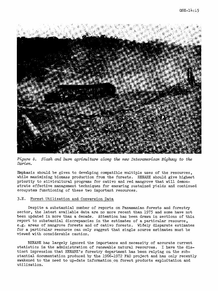
Figure 5. Slash and burn agriculture along the new Interamerican Highway to theDarien.
Emphasis should be given to devalcping compatible multiple uses of the resources,while maximizing biomass production from the forests. RENARE should give highestpriority to silvicultural programs for cativo and red mangrove that will demon-strate effective management techniques for ensuring sustained yields and continuedecosystem functioning of these two important resources.
3.E. Forest Utilization and Conversion Data
Despite a substantial number of reports on Panamanian forests and forestrysector, the latest available data are no more recent than 1975 and some have notbeen updated in more than a decade. Attention has been drawn in sections of thisreport to substantial discrepancies in the estimates of a particular resource,e.g. areas of mangrove forests and of cativo forests. Widely disparate estimatesfor a particular resource can only suggest that single source estimates must beviewed with considerable caution.
RENARE has largely ignored the importance and necessity of accurate currentstatistics in the administration of renewable natural resources. I have the dis-tinct impression that RENARE’s forestry department has been relying on the sub-stantial documentation produced by the 1966-1972 FA0 project and has only recentlyawakened to the need to up-date information on forest products exploitation andutilization.
GSH-14.: 16
Neither RENARE nor any of the collaborating international donors has plansto assess the status of forests and the rate of deforestation in Panama. RENAREacknowledges significant deforestation is occurring and joins the media and con-servationists in blaming it on uncontrolled agricultural colonization. But REN-ARE seems to prefer to be a passive bystander rather than exercise its legalresponsibilities to Panama’s natural resources.
3.F. Timber Utilization
Panama’s timber industry has been traditionally based on the utilization ofa small number of species to meet national demands for wood and wood products.If the literature is to be believed, the timber industry’s acceptance of speciesdecreased slightly in the past three decades. Due to cultural preferences, localavailability, uncontrolled exploitation, and the lack of appropriate wood tech-nology, few species are harvested from mixed tropical forests. There are numer-ous examples of a tree species having a highly preferred status in one countryand a lesser status in a neighboring country. FAO studies in Panama indicateabout 300 tree species have commercial potential.
The poor species acceptance by Panama’s timber industry is not representativeof the pattern in other Central American countries (excluding the pine-richcountries of Honduras and Guatemala), where local markets are rapidly acceptingnew timbers. The unchanging Panama situation is most likely due to the rapidopening of the Dari@n via the Interamerican Highway. Vast areas of virgin forestbecame accessible in the past decade, permitting an adequate supply of preferredlogs. Forest exploitation along the newly-opened sections of the highway arerestricted to "high-grading" of the few preferred species. Now that the highwayhas reached Yaviza and secondary road construction occurs slowly, the flow ofpremium timbers should decrease appreciably. As scarcity and inaccessibilitydrive up the prices of the preferred species, the national market should beginto accept new species.
Wood technology studies and information can play a key role in facilitatingentrance of lesser known woods into national markets. RENARE is the appropriateagency for wood technological information, but has done nothing in the areasince the FA0 project terminated in 1972. The new FAO project will include awood technologist to work on some of Panama’s potential timbers.
3.G. Rehabilitation of Degraded Soils
Deforested lands considered unsuitable for agriculture or pasture (Fig. 4)are estimated to cover between 10,000 km2 (Falla 1978a) and 18,000 km2 (MayoMendez in Anon. 1979). Mayo Mendez’ estimate is equivalent to 23% of the country.The majority of the degraded soils occur in the Pacific central region, includingmost of the Azuero Peninsula. Because of the dearth of natural vegetation inthe region, and the socio-cultural nature of the human population, it is completelyunrealistic to depend on or even consider natural .vegetation for soil rehabilita-tion. The only realistic possibility for soil rehabilitation is through reforest-ation. At least 50% of the degraded soils could be rehabilitated with commercialtree plantations. On degraded soils designated as protection areas, such aswatersheds, he natural vegetation should be allowed to recover, rather thanreforested wiith costly tree plantations that may not be as effective as naturalsecondary vegetation.
GSH-14-17
LITERATURE CITED
Anonymous. 1978. Integrated development project of the eastern region ofWashington. 308 pPanama-Darlen OAS,
Anonymous. 1979. Republica de Panama" DiagnSstico Ambiental. PNUMA, MexicoCity. Draft
Bennett, C. F. 1968. Human influences on the zoogeography of Panama. Ibero-americana 51"l-ll2.
Budowski, G. 1965. Distribution of tropical American rain forest species inthe light of successional processes. Turrialba 15(1)’40-42.
Deveaux, C. L. 1973. Patrimonio forestal delEstado. FAO/FO-SF/PAN 6, Rome,Informe tecn+/-co No. 16. 51 p.
Donaldson, P. 0. 1963. Forest resource development in Panama. Greenacres,Seattle. 81 p.
Falla, A. 1978a. Plan de desarrollo forestal. Estado actual del subsector.FA0/PCT/6/PAN/01/I, Panama, Informe t@cnico No. 1. 107 p.
Falla, A. 1978b. Plan de desarrollo forestal- Estudio de las perspectivas deldesarrollo forestal en Panama. FA0/PCT/6/PAN/01/I, Panama, Informetecnico No. 2. 95 P.
Garver, R. D. 1947. National survey of the forest resources of the Republicof Panama. State Dept., Washington. 28p.
Golley, F. B., J. T. McGinnis, R. G. Clements, G. I. Child and M. J. Duever.1975. Mineral Cycling in a Tropical Moist Forest Ecosystem. Univ. GeorgiaPress, Athens. 248 p.
Hartshorn, G. S. 1978. Tree falls and tropical forest dynamics, l__n P. B.Tomlinson and M. H. Zimmerman, eds. Tropical Trees as Living Systems.Cambridge Univ. Press, London. Pp. 617-638.
Holdridge, L. R. et al. 1958. Informe sobre un reconocimiento para establecerlas posibilidades de una industria de pulpa y papel en la provincia de Bocasdel Toro. Centro de Desarrollo Industrial del IFE, Panama.
Lamb, F. B. 1953. The forests of Darien. Carb. Forester. 14"128-135.
Rankin, J. W. 1963. Forest products potentials in Panama. Greenacres, Seattle
56 p.
Sauer, C. O. 1966. The Early Spanish Main. Univ. Calif. Press, Berkeley. 06 p.
Standley, P. C. 1928. Flora of the Panama Canal Zone. Contr. U.S. Nat. Herb.
27-1-416.
Tosi, J. A., Jr. 1971. Zonas de vida. Una base ecologica para investigacionessilvicolas e inventariacion forestal en la Republica de Panama.FAO/F0-SF/PAN 6, Rome, Informe tecnico No. 2. 123 p.
***Received in Hanover 8/3/81


![Glutathione-Dependent Formaldehyde … [7], and class III, the ancestral glu-tathione-dependent formaldehyde dehydrogenase (GSH-FDH) [8] are the most studied [9]. GSH-FDH oxidizes](https://img.pdfslide.us/doc/110x75/5b441aa77f8b9a1e778b60b8/glutathione-dependent-formaldehyde-7-and-class-iii-the-ancestral-glu-tathione-dependent.jpg)