Embed Size (px)
Citation preview

Institute for Environment and SustainabilityGlobal Vegetation Monitoring Unit
Joint Research Centre (JRC) of the EU, Italy Tel: 0039 0332 785769
E-mail: [email protected]
Kevin J. Tansey & Jean-Marie Grégoire
A global map of burnt vegetation at A global map of burnt vegetation at 1km resolution for the year 2000 1km resolution for the year 2000
derived from SPOT VGT dataderived from SPOT VGT data
WithLuigi Boschetti, Alessandro Brivio, Dmitry Ershov, Robert Fraser, Dean Graetz, Marta
Maggi, Ilaria Marengo, Pascal Peduzzi, Jose Pereira, João Silva, Adélia Sousa and Daniela Stroppiana

Institute for Environment and SustainabilityGlobal Vegetation Monitoring Unit
Burning IssuesBurning IssuesBiomass burning contributes up to 40% CO2, 16% CH4 and 45% CO of anthropogenic emissions

Institute for Environment and SustainabilityGlobal Vegetation Monitoring Unit
The GBA2000 InitiativeThe GBA2000 Initiative
The GLOBAL BURNT AREA 2000 Project
o Biomass burning and land cover change• Biodiversity, Desertification and Climate Change Conventions
o Biomass burning and atmospheric emission
• GHG and Aerosol / Climate change conventions
o In response to scientific community needs
• Climate and ecosystem modelers
• EU Development and Environment Policy
• Land use planners and decision makers
• Assistance to Kyoto Protocol validation experiments

Institute for Environment and SustainabilityGlobal Vegetation Monitoring Unit
The GBA2000 ApproachThe GBA2000 Approach
o SPOT4 VGT S1 global daily images• 4 spectral bands, 1 km resolution, surface reflectance
o 6 Dedicated regional algorithms• Performance of algorithms evaluated with TM data
• Selection of ‘best’ algorithm made outside regions
o Monthly/annual burnt area map products
o Statistics of burnt areas
o A documented and validated methodology
o Regional accuracy of the global product

Institute for Environment and SustainabilityGlobal Vegetation Monitoring Unit
Where the GBA2000 algorithms are applied

Institute for Environment and SustainabilityGlobal Vegetation Monitoring Unit
The months when the algorithms are applied

Institute for Environment and SustainabilityGlobal Vegetation Monitoring Unit
Information/Data AccessInformation/Data Access1: IMS hosted by UNEP GRID (Switzerland)• Interactive search features (region)
• Zoom in/out, pan etc.
• Select month of interest
• Change the background layer
• Overlay WCMC protected areas
• Overlay country borders
http://www.grid.unep.ch/activities/earlywarning/preview/ims/gba/
2: GBA2000 Website hosted by the JRC• Latest News
• Partner/Contact Info.
• Obtain reference/source information (also at UNEP)
• Download binary data (also at UNEP)
• View statistics (also at UNEP)
http://www.gvm.ies.jrc.it/fire/gba2000_website/index.htm

Institute for Environment and SustainabilityGlobal Vegetation Monitoring Unit
GBA2000 Statistical GBA2000 Statistical ProductsProducts
o Reporting at global scaleo Reporting at country/provincial levelo Reporting at protected area (PA) levelo Reporting at 1/2o, 1o grid & 5o strip levelso Reporting per land cover type
• University of Maryland global 1km land cover product (UMD)
• IGBP-DIS global land cover product (IGBP)
• JRC Global Land Cover 2000 (GLC2000) product
• MODIS global land cover product

Institute for Environment and SustainabilityGlobal Vegetation Monitoring Unit
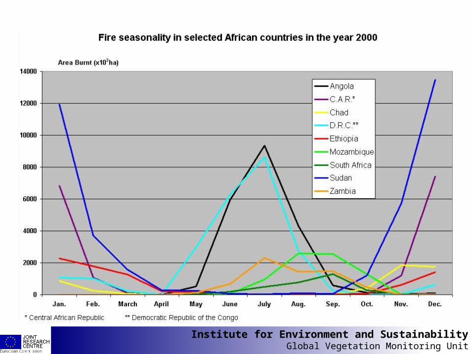
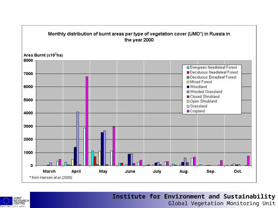
Fire SeasonalityFire SeasonalityDerived from the GBA2000 Product

Institute for Environment and SustainabilityGlobal Vegetation Monitoring Unit
Institute for Environment and SustainabilityGlobal Vegetation Monitoring Unit

Institute for Environment and SustainabilityGlobal Vegetation Monitoring Unit

Institute for Environment and SustainabilityGlobal Vegetation Monitoring Unit

Institute for Environment and SustainabilityGlobal Vegetation Monitoring Unit
Institute for Environment and SustainabilityGlobal Vegetation Monitoring Unit

Institute for Environment and SustainabilityGlobal Vegetation Monitoring Unit

Institute for Environment and SustainabilityGlobal Vegetation Monitoring Unit
1/21/2oo Grid Burned Area Grid Burned Area DensityDensity
% of the surface area of each 1/2o grid cell burnt in the year 2000
Alaska
Kazakhstan
Russia
Angola
DR Congo
Australia
USA
ArgentinaChile

Institute for Environment and SustainabilityGlobal Vegetation Monitoring Unit
55oo Land Strip Burned Area Land Strip Burned Area DensityDensity

Institute for Environment and SustainabilityGlobal Vegetation Monitoring Unit
JRC BA Analysis ModuleJRC BA Analysis Module

Institute for Environment and SustainabilityGlobal Vegetation Monitoring Unit
Algorithm PerformanceAlgorithm PerformanceSurface area accuracy of burn scars compared to TM data
Sampling grid of 15x15 km, regression line, R2, little effect due to the low resolution bias
UTL Europe R2 = 0.71UTL Africa R2 = 0.4 – 0.99 (site dependent)CNR R2 = 0.6
Per pixel confusion matrix using TM data
CNR OA = 82.3% – 87% (C. Africa)
Overall (OA), omission (OM) and commission (COM) map accuracies determined
IFI R2 = 0.89*
JRC (Stroppiana) COM = 36% (Australian tropical savannas)
* errors in burnt area mapping reported to be less than 15%
Burnt surface area statistics compared to inventories/fire surveysCCRS OM = 15.5% (2000)**
** OM in Canada in 1998 = 23%, 1999 = 11%. OM in the USA in 2000 = 6.6%
Work in progress: UOE/UTL and JRC(Boschetti)
Per pixel confusion matrix using a visual classification of 1km data

Institute for Environment and SustainabilityGlobal Vegetation Monitoring Unit
Next StepsNext Stepso Feedback on version -> end Novembero Regional assessment of the global product
• Using TM scenes not previously used for regional assessment
o Processing chain -> ESA (Globcarbon 98-03)o Use Global Fire Analysis GIS Modules (JRC)o Strengthen our collaboration with:
• Atmospheric modelers:ACE-ASIA (2001) - West Africa Monsoon (WAM) (2003)
Contribution to the EDGAR emission database
• Land cover change modelers:Land Use – Land Cover Change (LUCC) project of the
IGBP
Land resource managers

Institute for Environment and SustainabilityGlobal Vegetation Monitoring Unit
ConclusionsConclusions
o A global ‘high resolution’ map of areas burnt from a single source of information
o The methods used are fully documented which allows:
• (i) Repeatability and (ii) Evaluation from the users.
o A similar multi-annual dataset (1998-2003) will be produced:
• By ESA (with co-operation from the JRC) in the context of the GLOBCARBON initiative.